


Logistic Regression Fitting of Rainfall-Induced Landslide Occurrence Probability and Continuous Landslide Hazard Prediction Modelling
-
摘要:
提高降雨型滑坡危险性预警精度和空间辨识度具有重要意义.以江西宁都县1980—2001年156个降雨型滑坡为例,首先基于传统的EE-D(early effective rainfall-rainfall duration)阈值法计算不同降雨诱发滑坡的时间概率级别;然后以各级别临界降雨阈值曲线对应的时间概率为因变量,并以对应的前期有效降雨量(early effective rainfall,EE)和降雨历时(D)为自变量,采用逻辑回归拟合出上述因变量与自变量之间的非线性关系,得到降雨诱发滑坡的连续概率值;之后对比C5.0决策树和多层感知器的滑坡易发性预测性能;最后利用降雨诱发滑坡的连续概率值与易发性图相耦合以实现连续概率滑坡危险性预警.结果显示:(1)宁都降雨型滑坡连续概率值的逻辑回归方程为1/P=1+e4.062+0.747 4×D-0.079 44×EE,其拟合优度为0.983;(2)2002—2003年的20处用于连续概率阈值测试的降雨型滑坡大都落在连续概率值大于0.7的区域,只有4处落在小于0.7的区域;(3)C5.0决策树预测滑坡易发性的精度显著高于多层感知器;(4)近5年的4次降雨型滑坡的连续概率危险性值都在0.8以上,且高和极高预警区的面积较传统滑坡危险性分区更小.可见连续概率滑坡危险性预警法相较于传统危险性分区法具有更高的预警精度和空间辨识度,且通过叠加滑坡易发性图及其临界降雨阈值可开展实时滑坡危险性预警制图.
Abstract:It is significant to improve the warning accuracy and spatial identification of rainfall-induced landslides. This study takes 156 typical rainfall-induced landslide events from 1980 to 2001 in Ningdu County Jiangxi Province, China as a case. Firstly, the time probability levels of different rainfall-induced landslides are calculated based on traditional EE-D (early effective rainfall-rainfall duration) threshold. Then taking each time probability corresponding to each level critical rainfall threshold curve as dependent variable, and its early effective rainfall (early effective rainfall, EE) and rainfall duration (D) as independent variables, logistic regression is adopted to fitting nonlinear mapping relationship between probability of rainfall-induced landslides and EE and D to obtain continuous probability of landslides. Furthermore, prediction performance of landslide susceptibility between C5.0 decision tree and multilayer perceptron is compared. Finally, continuous probability of rainfall-induced landslides is coupled with landslide susceptibility to realize continuous landslide hazard warning. Results show follows: (1) logistic regression fitting equation of continuous probability rainfall-induced landslides is 1/P=1+e4.062+0.747 4×D-0.079 44×EE with R2 of 0.983. (2) most of 20 rainfall-induced landslides from 2002 to 2003 used for continuous probability critical rainfall threshold test fell in areas with continuous probability greater than 0.7, and only 4 of them fell in areas less than 0.7. (3) the C5.0 DT model has a better prediction performance than the multilayer perceptron. (4) the continuous probability hazard values of four rainfall-type landslides in the past five years are above 0.8, and the areas of high and very high warning zone are smaller than those of traditional landslide hazard warning. It is concluded that compared with the traditional hazard zoning method, the continuous landslide hazard warning method has higher warning accuracy and spatial identification, and the real time landslide hazard map carrying out spatial and time warning can be obtained through combination of landslide critical rainfall threshold and landslide susceptibility map.
-
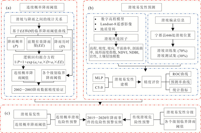
图 1 降雨型滑坡连续概率危险性预警流程图
Fig. 1. Flow chart of continuous probability hazard warning of rainfall induced landslides

图 2 滑坡发生当日降雨量与前期有效降雨量
Fig. 2. Daily rainfall and early effective rainfall of landslides
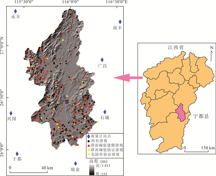
图 5 宁都地理位置、降雨站点和滑坡分布
Fig. 5. Geological locations of Ningdu County, rainfall station and landslide distribution
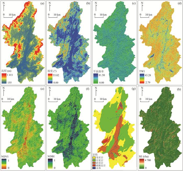
图 6 部分影响因子分布
a.高程;b.坡度;b.平面曲率;d.TWI;e.NDVI;f.NDBI;g.岩性;h.SE
Fig. 6. Distribution maps of most influencing factors
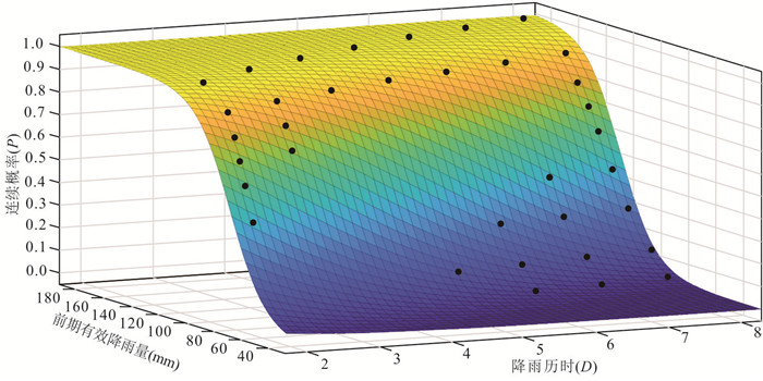
图 9 各降雨参数条件下滑坡发生的连续概率值
Fig. 9. Continuous probability of landslide occurrence under various rainfall parameters
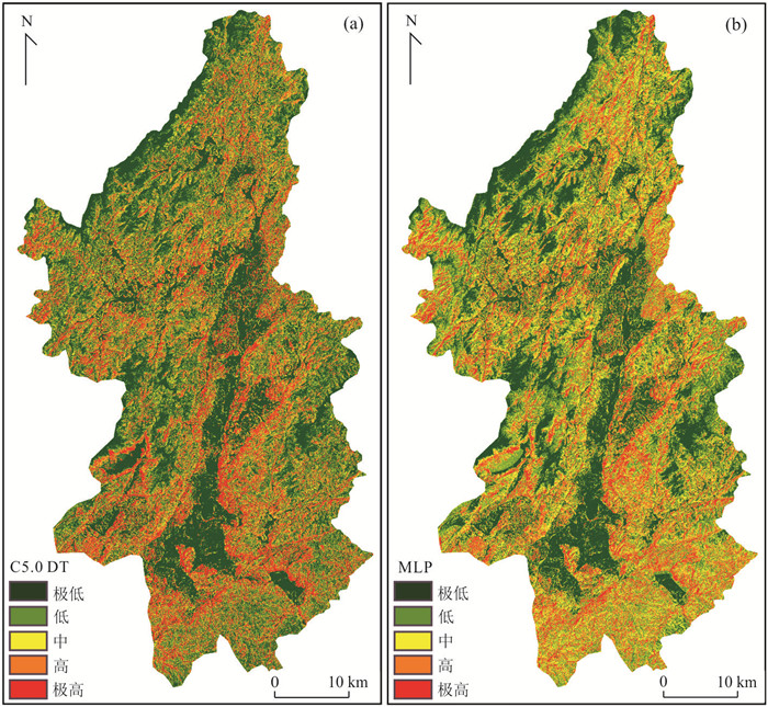
图 12 C5.0 DT易发性分级图(a)和MLP易发性分级图(b)
Fig. 12. Landslide susceptibility maps of C5.0 DT model (a) and MLP model (b)
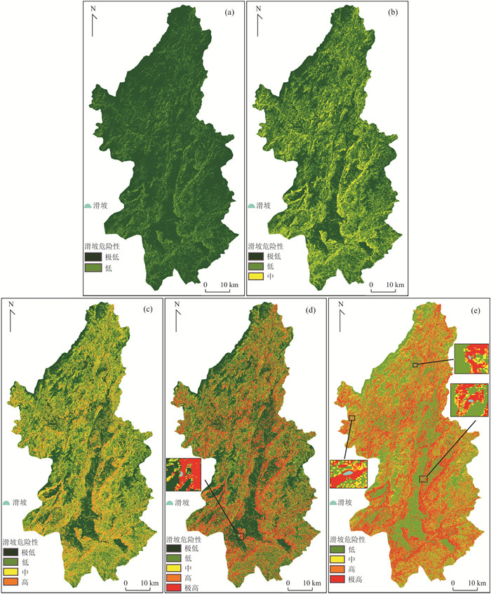
图 14 各降雨阈值级别与易发性叠加的传统危险性分级
Fig. 14. Traditional hazard maps of rainfall threshold levels superposed on susceptibility maps
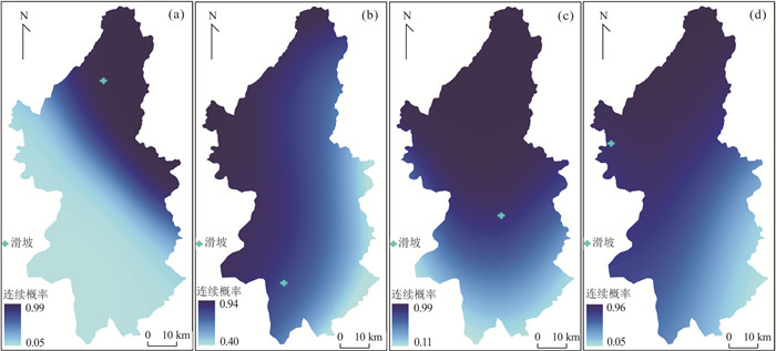
图 15 各事件当天降雨型滑坡连续概率
Fig. 15. Continuous probability maps of rainfall induced-landslide on the day of rainfall events
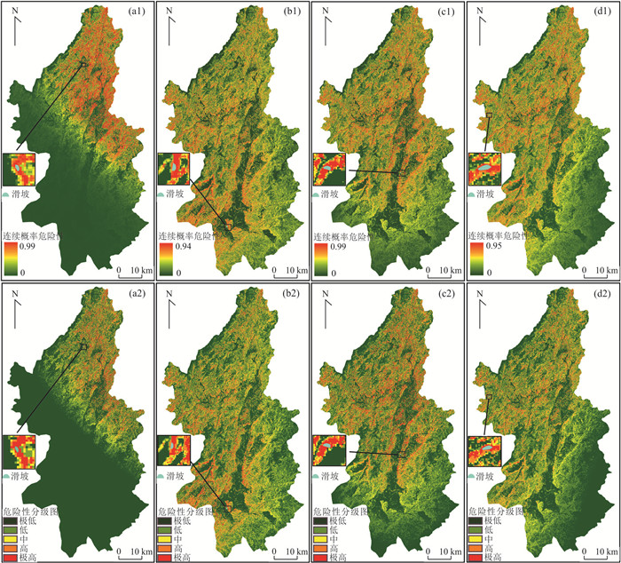
图 16 各降雨事件滑坡当天连续概率滑坡危险性
a1~d1各降雨事件下的连续概率危险性预警图,a2~d2连续概率危险性预警图对应的危险性级别划分图
Fig. 16. Continuous probability landslide hazard maps of rainfall events on the day of landslide occurrence
表 1 传统各滑坡易发性与临界降雨阈值组合下的危险性预警区域
Table 1. Traditional landslide hazard warning using landslide susceptibility and multistage critical rainfall threshold
危险性预警级别 T1(0%~15%) T2(15%~45%) T3(45%~70%) T4(70%~90%) T5(90%~100%) S1(0.0~0.2) 极低 极低 极低 极低 低 S2(0.2~0.4) 极低 极低 低 低 中 S3(0.4~0.6) 极低 低 中 中 高 S4(0.6~0.8) 极低 低 中 高 极高 S5(0.8~1.0) 低 中 高 极高 极高  下载: 导出CSV
表 2 各因子的频率比和相关描述
Table 2. Frequency ratio and related description of each influencing factor
因子 分级 频率比 因子 分级 频率比 因子 分级 频率比 高程(m) 155~243 1.144 剖面曲率 0.0~1.5 0.736 坡度(°) 0.0~3.5 0.201 243~322 1.218 1.5~3.0 1.125 3.5~7.2 1.144 322~411 1.127 3.0~4.7 1.172 7.2~11.2 1.711 411~509 0.834 4.7~6.4 1.047 11.2~15.1 1.386 509~617 0.561 6.4~8.5 1.021 15.1~19.3 0.991 617~750 0.347 8.5~11.0 1.083 19.3~24.1 0.657 750~938 0.022 11.0~14.7 0.884 24.1~30.3 0.562 938~1 411 0 14.7~32.4 0.708 30.3~53.0 0.296 TWI 3.8~6.6 1.149 坡向 -1.0~45.7 0.599 NDVI 0~0.289 0.421 6.6~8.2 1.158 45.7~91.0 0.649 0.289~0.449 1.046 8.2~10.0 0.846 91.0~133.4 1.105 0.449~0.536 1.458 10.0~12.6 0.464 133.4~177.3 1.048 0.536~0.608 1.336 12.6~16.2 0.544 177.3~224.0 1.138 0.608~0.667 1.117 16.2~26.4 0.692 224.0~270.8 1.108 0.667~0.724 0.997 26.4~39.0 0 270.8~314.6 1.223 0.724~0.782 0.914 39.0~43.3 1.149 314.6~359.9 0.965 0.782~1.000 0.596 平面曲率 0~9.9 1.359 NDBI 0~0.137 0.481
岩性碎屑岩 0.746 9.9~18.2 1.342 0.137~0.179 0.804 岩浆岩 0.832 变质岩 1.347 18.2~27.4 1.091 0.179~0.221 1.181 碳酸盐岩 1.587 27.4~37.3 0.993 0.221~0.274 1.466 土壤侵蚀(t/ha) 0~5 0.847 37.3~47.9 0.720 0.274~0.358 1.400 5~25 1.287 47.9~58.8 0.524 0.358~0.389 1.139 25~50 1.592 58.8~70.6 0.351 0.389~0.589 0.873 50~80 1.635 70.6~81.5 0.458 0.589~1.000 1.070 80~4 700 2.272
下载: 导出CSV
表 3 宁都8个站点的位置和平均年降雨量
Table 3. Location and average annual rainfall of eight stations in Ningdu County
站名 于都 南丰 兴国 永丰 宁都 广昌 石城 瑞金 站点编号 58905 58718 58804 58705 58806 58813 58814 58903 经度(°) 115.41 116.53 115.35 115.41 116.01 116.33 116.35 116.03 纬度(°) 25.96 27.21 26.35 27.33 26.48 26.85 26.35 25.86 高程(m) 132 111 147 85 209 143 229 193 平均年降雨量(mm) 1 749.45 1 651.51 1 508.27 1 775.66 1 882.37 1 790.84 1 865.94 1 784.60
下载: 导出CSV
表 4 各个级别临界降雨阈值概率及所对应的前期有效降雨量和降雨历时
Table 4. Probability of multistage critical rainfall threshold with corresponding early effective rainfall and duration
D P=0 P=0.05 P=0.15 P=0.3 P=0.45 P=0.6 P=0.7 P=0.8 P=0.9 P=1.0 2 34 44 50 60 66 72 76 80 85 102 3 41 52 60 71 79 86 90 95 101 121 4 46 59 68 81 89 97 102 108 114 137 5 50 65 74 89 98 106 112 118 125 151 6 55 70 80 96 106 115 121 128 136 163 7 58 75 86 102 113 123 130 137 145 174 8 62 79 91 108 120 130 137 145 153 184
下载: 导出CSV
表 5 2015—2020年宁都县降雨型滑坡发生的降雨数据
Table 5. Rainfall data of rainfall induced landslides from 2015 to 2020
发生时间 地点 当日
降雨量前一天
降雨量前二天
降雨量前三天
降雨量前四天
降雨量前五天
降雨量前六天降雨量 前七天
降雨量2020-06-09(a事件) 东韶乡琳池村 33.29 93.67 6.96 23.82 36.42 54.32 0 2.38 2019-07-09(b事件) 城北门刘城塘 53.21 35.46 26.60 20.51 0.23 6.86 4.29 0 2019-06-09(c事件) 黄石镇江口村 0.00 72.19 10.67 102.02 0 1.5 2.9 14.5 2015-11-18(d事件) 大沽乡阳霁村 37.54 48.85 42.70 0.76 1.32 0 6.77 22.92
下载: 导出CSV
表 6 各降雨事件下的降雨型滑坡连续概率及其危险性值
Table 6. Continuous probability and hazard of rainfall induced landslides under rainfall events
降雨事件 降雨历时 有效降雨量 降雨型滑坡连续概率 易发性 连续概率危险性 2020-06-09(a事件) 6 157.59 0.981 0.914 0.897 2019-07-09(b事件) 4 109.10 0.834 1.0 0.834 2019-06-09(c事件) 4 115.79 0.895 0.918 0.822 2015-11-18(d事件) 3 103.94 0.875 1.0 0.875
下载: 导出CSV
表 7 连续概率危险性和传统危险性预警区域高和极高面积
Table 7. High and very high area of warning area under continuous probability hazard and traditional hazard
降雨事件 连续概率危险性预警区 传统危险性预警区域 高危险区栅格数和
面积占比(%)极高危险区栅格和
面积占比(%)高危险区栅格和
面积占比(%)极高危险区栅格和
面积占比(%)2020-06-09(a事件) 201 702 4.45 105 251 2.32 610 296 13.48 1 224 585 27.04 2019-07-09(b事件) 569 620 12.58 146 677 3.24 652 072 14.40 626 714 13.84 2019-06-09(c事件) 472 215 10.43 245 958 5.43 610 296 13.48 1 224 585 27.04 2015-11-18(d事件) 424 189 9.37 90 494 1.99 610 296 13.48 1 224 585 27.04
下载: 导出CSV
-
Aditian, A., Kubota, T., Shinohara, Y., 2018. Comparison of GIS⁃Based Landslide Susceptibility Models Using Frequency Ratio, Logistic Regression, and Artificial Neural Network in a Tertiary Region of Ambon, Indonesia. Geomorphology, 318: 101-111. https://doi.org/10.1016/j.geomorph.2018.06.006 Althuwaynee, O. F., Asikoglu, O., Eris, E., 2018. Threshold Contour Production of Rainfall Intensity that Induces Landslides in Susceptible Regions of Northern Turkey. Landslides, 15(8): 1541-1560. https://doi.org/10.1007/s10346⁃018⁃0968⁃2 Arabameri, A., Pradhan, B., Lombardo, L., 2019. Comparative Assessment Using Boosted Regression Trees, Binary Logistic Regression, Frequency Ratio and Numerical Risk Factor for Gully Erosion Susceptibility Modelling. CATENA, 183: 104223. https://doi.org/10.1016/j.catena.2019.104223 Chahal, P., Rana, N., Champati, R. P. K., et al., 2017. Identification of Landslide⁃Prone Zones in the Geomorphically and Climatically Sensitive Mandakini Valley, (Central Himalaya), for Disaster Governance Using the Weights of Evidence Method. Geomorphology, 284: 41-52. https://doi.org/10.1016/j.geomorph.2016.11.008 Chen, T., Zhong, Z. Y., Niu, R. Q., et al., 2020. Mapping Landslide Susceptibility Based on Deep Belief Network. Geomatics and Information Science of Wuhan University, 45(11): 1809-1817(in Chinese with English abstract). Chen, W., Peng, J. B., Hong, H. Y., et al., 2018. Landslide Susceptibility Modelling Using GIS⁃Based Machine Learning Techniques for Chongren County, Jiangxi Province, China. Science of the Total Environment, 626: 1121-1135. https://doi.org/10.1016/j.scitotenv.2018.01.124 Finicelli, G. F., Confuorto, P., Carratù, M. T., et al., 2016. Multivariate Statistical Approach vs. Deterministic Physically Based Model for Landslide Susceptibility Assessment. Rendiconti Online Della Società Geologica Italiana, 41: 151-154. https://doi.org/10.3301/rol.2016.116 Guo, Z. Z., Yin, K. L., Liu, Q. L., et al., 2020. Rainfall Warning of Creeping Landslide in Yunyang County of Three Gorges Reservoir Region Based on Displacement Ratio Model. Earth Science, 45(2): 672-684(in Chinese with English abstract). Harilal, G. T., Madhu, D., Ramesh, M. V., et al., 2019. Towards Establishing Rainfall Thresholds for a Real⁃Time Landslide Early Warning System in Sikkim, India. Landslides, 16(12): 2395-2408. https://doi.org/10.1007/s10346⁃019⁃01244⁃1 Hong, H. Y., Liu, J. Z., Zhu, A. X., 2020. Modeling Landslide Susceptibility Using LogitBoost Alternating Decision Trees and Forest by Penalizing Attributes with the Bagging Ensemble. Science of the Total Environment, 718: 137231. https://doi.org/10.1016/j.scitotenv.2020.137231 Hong, H. Y., Pourghasemi, H. R., Pourtaghi, Z. S., 2016. Landslide Susceptibility Assessment in Lianhua County (China): A Comparison between a Random Forest Data Mining Technique and Bivariate and Multivariate Statistical Models. Geomorphology, 259: 105-118. https://doi.org/10.1016/j.geomorph.2016.02.012 Hong, M., Kim, J., Jeong, S., 2018. Rainfall Intensity⁃Duration Thresholds for Landslide Prediction in South Korea by Considering the Effects of Antecedent Rainfall. Landslides, 15(3): 523-534. https://doi.org/10.1007/s10346⁃017⁃0892⁃x Huang, F. M., Chen, J. W., Du, Z., et al., 2020a. Landslide Susceptibility Prediction Considering Regional Soil Erosion Based on Machine⁃Learning Models. ISPRS International Journal of Geo⁃Information, 9(6): 377. https://doi.org/10.3390/ijgi9060377 Huang, F. M., Zhang, J., Zhou, C. B., et al., 2020b. A Deep Learning Algorithm Using a Fully Connected Sparse Autoencoder Neural Network for Landslide Susceptibility Prediction. Landslides, 17(1): 217-229. https://doi.org/10.1007/s10346⁃019⁃01274⁃9 Huang, F. M., Ye, Z., Yao, C., et al., 2020. Uncertainties of Landslide Susceptibility Prediction: Different Attribute Interval Divisions of Environmental Factors and Different Data⁃Based Models. Earth Science, 45(12): 4535-4549(in Chinese with English abstract). Huang, F. M., Yin, K. L., Jiang, S. H., et al., 2018. Landslide Susceptibility Assessment Based on Clustering Analysis and Support Vector Machine. Chinese Journal of Rock Mechanics and Engineering, 37(1): 156-167(in Chinese with English abstract). Khosravi, K., Pham, B. T., Chapi, K., et al., 2018. A Comparative Assessment of Decision Trees Algorithms for Flash Flood Susceptibility Modeling at Haraz Watershed, Northern Iran. Science of the Total Environment, 627: 744-755. https://doi.org/10.1016/j.scitotenv.2018.01.266 Lee, S., Won, J. S., Jeon, S. W., et al., 2015. Spatial Landslide Hazard Prediction Using Rainfall Probability and a Logistic Regression Model. Mathematical Geosciences, 47(5): 565-589. https://doi.org/10.1007/s11004⁃014⁃9560⁃z Lepore, C., Arnone, E., Noto, L. V., et al., 2013. Physically Based Modeling of Rainfall⁃Triggered Landslides: A Case Study in the Luquillo Forest, Puerto Rico. Hydrology and Earth System Sciences, 17(9): 3371-3387. https://doi.org/10.5194/hess⁃17⁃3371⁃2013 Liu, J., Li, S. L., Chen, T., 2018. Landslide Susceptibility Assesment Based on Optimized Random Forest Model. Geomatics and Information Science of Wuhan University, 43(7): 1085-1091(in Chinese with English abstract). Liu, L., Yin, K. L., Wang, J. J., et al., 2016. Dynamic Evaluation of Regional Landslide Hazard Due to Rainfall: A Case Study in Wanzhou Central District, Three Gorges Reservoir. Chinese Journal of Rock Mechanics and Engineering, 35(3): 558-569(in Chinese with English abstract). Ma, T. H., Li, C. J., Lu, Z. M., et al., 2014. An Effective Antecedent Precipitation Model Derived from the Power⁃Law Relationship between Landslide Occurrence and Rainfall Level. Geomorphology, 216: 187-192. https://doi.org/10.1016/j.geomorph.2014.03.033 Mathew, J., Babu, D. G., Kundu, S., et al., 2014. Integrating Intensity–Duration⁃Based Rainfall Threshold and Antecedent Rainfall⁃Based Probability Estimate towards Generating Early Warning for Rainfall⁃Induced Landslides in Parts of the Garhwal Himalaya, India. Landslides, 11(4): 575-588. https://doi.org/10.1007/s10346⁃013⁃0408⁃2 Nsengiyumva, J. B., Luo, G. P., Amanambu, A. C., et al., 2019. Comparing Probabilistic and Statistical Methods in Landslide Susceptibility Modeling in Rwanda/Centre⁃Eastern Africa. Science of the Total Environment, 659: 1457-1472. https://doi.org/10.1016/j.scitotenv.2018.12.248 Peruccacci, S., Brunetti, M. T., Gariano, S. L., et al., 2017. Rainfall Thresholds for Possible Landslide Occurrence in Italy. Geomorphology, 290: 39-57. https://doi.org/10.1016/j.geomorph.2017.03.031 Peruccacci, S., Brunetti, M. T., Luciani, S., et al., 2012. Lithological and Seasonal Control on Rainfall Thresholds for the Possible Initiation of Landslides in Central Italy. Geomorphology, 139-140: 79-90. https://doi.org/10.1016/j.geomorph.2011.10.005 Pourghasemi, H. R., Pradhan, B., Gokceoglu, C., 2012. Application of Fuzzy Logic and Analytical Hierarchy Process (AHP) to Landslide Susceptibility Mapping at Haraz Watershed, Iran. Natural Hazards, 63(2): 965-996. https://doi.org/10.1007/s11069⁃012⁃0217⁃2 Pradhan, A. M. S., Lee, S. R., Kim, Y. T., 2019. A Shallow Slide Prediction Model Combining Rainfall Threshold Warnings and Shallow Slide Susceptibility in Busan, Korea. Landslides, 16(3): 647-659. https://doi.org/10.1007/s10346⁃018⁃1112⁃z Rosi, A., Peternel, T., Jemec⁃Auflič, M., et al., 2016. Rainfall Thresholds for Rainfall⁃Induced Landslides in Slovenia. Landslides, 13(6): 1571-1577. https://doi.org/10.1007/s10346⁃016⁃0733⁃3 Rossi, M., Luciani, S., Valigi, D., et al., 2017. Statistical Approaches for the Definition of Landslide Rainfall Thresholds and Their Uncertainty Using Rain Gauge and Satellite Data. Geomorphology, 285: 16-27. https://doi.org/10.1016/j.geomorph.2017.02.001 Salciarini, D., Fanelli, G., Tamagnini, C., 2017. A Probabilistic Model for Rainfall⁃Induced Shallow Landslide Prediction at the Regional Scale. Landslides, 14(5): 1731-1746. https://doi.org/10.1007/s10346⁃017⁃0812⁃0 Segoni, S., Lagomarsino, D., Fanti, R., et al., 2015. Integration of Rainfall Thresholds and Susceptibility Maps in the Emilia Romagna (Italy) Regional⁃Scale Landslide Warning System. Landslides, 12(4): 773-785. https://doi.org/10.1007/s10346⁃014⁃0502⁃0 Segoni, S., Piciullo, L., Gariano, S. L., 2018. A Review of the Recent Literature on Rainfall Thresholds for Landslide Occurrence. Landslides, 15(8): 1483-1501. https://doi.org/10.1007/s10346⁃018⁃0966⁃4 Sheng, Y. F., Li, Y. Y., Xu, Y., et al., 2019. Prediction of Rainfall⁃Type Landslides Based on Effective Rainfall Intensity and Logistic Regression. Hydrogeology & Engineering Geology, 46(1): 156-162, 172(in Chinese with English abstract). Wu, X. L., Yang, J. Y., Niu, R. Q., 2020. A Landslide Susceptibility Assessment Method Using SMOTE and Convolutional Neural Network. Geomatics and Information Science of Wuhan University, 45(8): 1223-1232(in Chinese with English abstract). Wu, Y. M., Lan, H. X., Gao, X., et al., 2015. A Simplified Physically Based Coupled Rainfall Threshold Model for Triggering Landslides. Engineering Geology, 195: 63-69. https://doi.org/10.1016/j.enggeo.2015.05.022 Wu, Y. P., Zhang, Q. X., Tang, H. M., et al., 2014. Landslide Hazard Warning Based on Effective Rainfall Intensity. Earth Science, 39(7): 889-895(in Chinese with English abstract). Yang, H. J., Wei, F. Q., Ma, Z. F., et al., 2020. Rainfall Threshold for Landslide Activity in Dazhou, Southwest China. Landslides, 17(1): 61-77. https://doi.org/10.1007/s10346⁃019⁃01270⁃z 陈涛, 钟子颖, 牛瑞卿, 等, 2020. 利用深度信念网络进行滑坡易发性评价. 武汉大学学报(信息科学版), 45(11): 1809-1817. https://www.cnki.com.cn/Article/CJFDTOTAL-WHCH202011018.htm 郭子正, 殷坤龙, 刘庆丽, 等, 2020. 基于位移比模型的三峡库区云阳县域内蠕变型滑坡降雨预警. 地球科学, 45(2): 672-684. doi: 10.3799/dqkx.2019.005 黄发明, 叶舟, 姚池, 等, 2020. 滑坡易发性预测不确定性: 环境因子不同属性区间划分和不同数据驱动模型的影响. 地球科学, 45(12): 4535-4549. doi: 10.3799/dqkx.2020.247 黄发明, 殷坤龙, 蒋水华, 等, 2018. 基于聚类分析和支持向量机的滑坡易发性评价. 岩石力学与工程学报, 37(1): 156-167. https://www.cnki.com.cn/Article/CJFDTOTAL-YSLX201801016.htm 刘坚, 李树林, 陈涛, 2018. 基于优化随机森林模型的滑坡易发性评价. 武汉大学学报(信息科学版), 43(7): 1085-1091. https://www.cnki.com.cn/Article/CJFDTOTAL-WHCH201807017.htm 刘磊, 殷坤龙, 王佳佳, 等, 2016. 降雨影响下的区域滑坡危险性动态评价研究: 以三峡库区万州主城区为例. 岩石力学与工程学报, 35(3): 558-569. https://www.cnki.com.cn/Article/CJFDTOTAL-YSLX201603013.htm 盛逸凡, 李远耀, 徐勇, 等, 2019. 基于有效降雨强度和逻辑回归的降雨型滑坡预测模型. 水文地质工程地质, 46 (1): 156-162, 172. https://www.cnki.com.cn/Article/CJFDTOTAL-SWDG201901021.htm 武雪玲, 杨经宇, 牛瑞卿, 2020. 一种结合SMOTE和卷积神经网络的滑坡易发性评价方法. 武汉大学学报(信息科学版), 45(8): 1223-1232. https://www.cnki.com.cn/Article/CJFDTOTAL-WHCH202008013.htm 吴益平, 张秋霞, 唐辉明, 等, 2014. 基于有效降雨强度的滑坡灾害危险性预警. 地球科学, 39(7): 889-895. https://www.cnki.com.cn/Article/CJFDTOTAL-DQKX201407011.htm -


 点击查看大图
计量
- 文章访问数: 1636
- HTML全文浏览量: 680
- PDF下载量: 131
- 被引次数: 0
