


Paleogeographic Pattern of Hankou and Hanjiang Estuary 350 Years Ago
-
摘要: 汉口是武汉三镇之一,华中地区的政治、金融、商贸、对外交往中心和重要的交通枢纽,自古被誉为“楚中第一繁盛处”,以“东方芝加哥”驰名于海内外.汉口并不是武汉的一个行政单元,大致为武汉市江岸区、江汉区、硚口区三个行政区所辖范围.汉口的崛起赖于地理环境优势已为学界所共识.汉口地处汉江河口区腹地,是长江和汉江相互作用区,地理环境多变、时空演化复杂,不同时期有不同的地理格局.本文以1669年的《汉阳府境全图》为主,结合其他文献,对繁盛一时的清代康熙年间的汉口古地理状况进行了复原.研究发现,当时的汉口地域存在着玉带河、襄河、沦河3条河流,且具“河湖一体”的特点;沿河发育有高大的天然堤,成为先民居住的主要地貌单元.汉江自蔡甸城头山东发生分流,先后以5条分支河道入江;此时的汉江河口三角洲顶分流点在城头山附近,河口分流区范围大致在以城头山‒谌家矶‒小军山为边界的区域内.汉口镇位于汉江与玉带河之间,即由汉江天然堤与袁公堤所构成的围垸内,市镇和公共文化建筑反映出当时的汉口镇已十分繁盛.汉口镇以外区域的聚落主要集中于河流天然堤上,这种人居地貌环境格局一直持续到20世纪初张公堤的修建.本研究首次揭示了清康熙时期的汉江河口区的古地理格局,对武汉市历史古地理演化与人地关系的认识有重要意义.Abstract: Hankou is one of the three towns of Wuhan. It is the center of politics, finance, commerce and trade, foreign exchanges and an important transportation hub in central China. It has been known as "the first flourishing place in Chu" since ancient times and is known both at home and abroad as "The Chicago of the East". Hankou is not an administrative unit of Wuhan, but an region roughly under the jurisdiction of three administrative areas including Jiangan District, Jianghan District and Qiaokou District. It has been widely recognized that the rise of Hankou depended on the advantages of geographical environment. Located in the hinterland of the Hanjiang River estuary area, Hankou is an interaction area between the Yangtze River and the Hanjiang River. The geographical environment is changeable, the space-time evolution is complex, and there are different geographical patterns in different periods. Based on the Whole Map of Hanyang Prefecture in 1669 and other documents, this paper restores the ancient geography of Hankou during the reign of Kangxi in the Qing Dynasty. It is found that there were three rivers in Hankou area at that time, namely, Yudai River, Xianghe River and Lunhe River, which had the characteristics of "integrating rivers and lakes". Along the river, there were tall natural levees, which became the main geomorphic unit for the ancestors to live. Hanjiang River diverts from the east of Chengtou mountain in Caidian, which has 5 branch channels. During that period, the peak of the estuary distributary area of Hanjiang River the peak of the Hanjiang River estuary delta was near Chengtou Mountain, and the range of the estuary distributary area of Hanjiang River the Hanjiang River estuary delta was roughly within the boundary area of Chengtou Mountain-Shenjiaji-Xiaojun Mountain. Hankou Town was located between the Hanjiang River and the Yudai River, that is, within the enclosure dike formed by the natural levee of the Hanjiang River and the Yuangong Dike. The town and its public cultural buildings reflect the prosperity of Hankou Town at that time. The settlements outside Hankou Town were mainly concentrated on the natural levee, which lasted until the construction of Zhanggong Dike in the early 20th century. This study reveals for the first time the pattern of Hankou paleogeography in the Kangxi period of Qing Dynasty, which is of great significance to the understanding of the historical paleogeography evolution of Wuhan and the relationship between man and land. At the same time, it has certain reference value to the study of human settlement paleogeography in inland river estuary area and the geographical background of the rise of city.
-
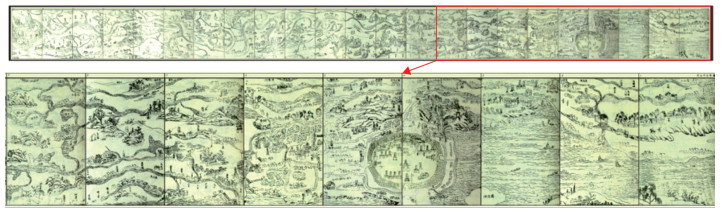
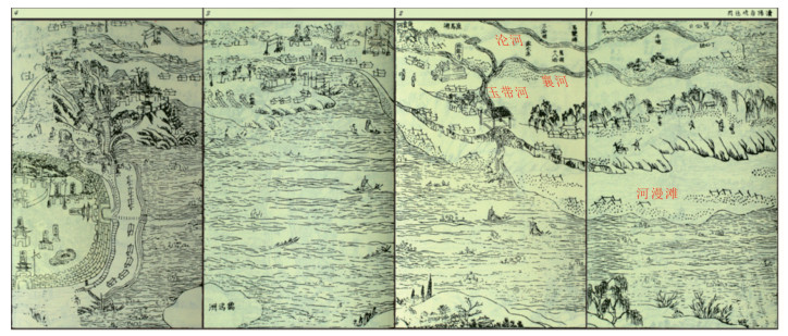
图 1 拼接后的《汉阳府境全图》(武汉市境内)
Fig. 1. Wuhan of the whole map of Hanyang prefecture after splicing
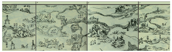
图 3 汉江分流口分布
1,2. 狗儿湾分流;3. 黄金口分流;4. 郭茨口北向分流;5. 郭茨口南向分流
Fig. 3. Distribution of diversion outlet of Han river
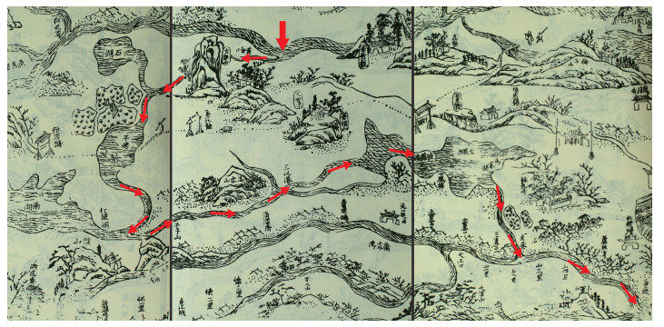
图 4 黄金口分流河道(图中箭头为推测的河流路径)
Fig. 4. HuangJinkou distributary channel (the arrows in the figure show the presumed river path)
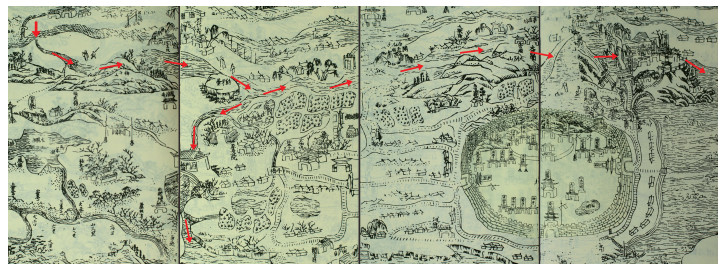
图 5 郭茨口分流河道(图中箭头为推测的河流路径)
Fig. 5. Guocikou distributary channel (the arrows in the figure show the presumed river path)
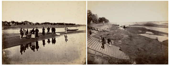
图 6 1870‒1887年间的汉口长江河漫滩(据宝记照相馆)
Fig. 6. Floodplain of Changjiang in Hankou from 1870 to 1887 (by Pow Kee photographer)
-
Cai, S. M., Guan, Z. H., 1982. The Ungrounded Hypothesis of the Presence of the Ancient Yunmeng Swamp Traversing South and North of River Changjiang on the Jianghan–Dongting Plain: Second Comments on the Ancient Yunmeng Swamp. Oceanologia et Limnologia Sinica, 13(2): 129-142 (in Chinese with English abstract). Chin, A., 2006. Urban Transformation of River Landscapes in a Global Context. Geomorphology, 79(3-4): 460-487. https://doi.org/10.1016/j.geomorph.2006.06.033 Deng, X. J., Xu, Y. P., Han, L. F., et al., 2015. Impacts of Urbanization on River Systems in the Taihu Region, China. Water, 7(12): 1340-1358. https://doi.org/10.3390/w7041340 Fan, C. D., 2002. Wu Chuan Lu (Travel Notes of Fan Chengda). Zhonghua Book Company, Beijing (in Chinese). Han, L. F., Xu, Y. P., Lei, C. G., et al., 2016. Degrading River Network Due to Urbanization in Yangtze River Delta. Journal of Geographical Sciences, 26(6): 694-706. https://doi.org/10.1007/s11442–016–1293–0 Harden, C. P., 2006. Human Impacts on Headwater Fluvial Systems in the Northern and Central Andes. Geomorphology, 79(3-4): 249-263. https://doi.org/10.1016/j.geomorph.2006.06.021 Li, C. A., Zhang, Y. F., 2021. The Formation and Development of Wuhan City and the Evolution of Man-Land Relationship. Acta Geologica Sinica, 95(3): 940-942 (in Chinese with English abstract). Li, Z. L., Liu, C. M., Hao, X. P., et al., 2021. Theoretical Basis and Priority Areas of the Interconnected River System Network Research. Acta Geographica Sinica, 76(3): 513-524 (in Chinese with English abstract). Liu, S. J., 1992. A Preliminary Study on the Historical Geography of Wuhan Municipality. Historical Geography, (10): 117-127 (in Chinese with English abstract). Local Chronicles Office of Hanyang District, Wuhan, 2013. Records of Hanyang Prefecture in Kangxi Period. Hubei People's Publishing House, Wuhan (in Chinese). Lu, J. Y., Huang, Y., Zhang, B. Y., 1996. Study on Regulation of Wuhan Reach of Yangtze River. Journal of Yangtze River Scientific Research Institute, 13(4): 15-19 (in Chinese with English abstract). Lu, J. Y., Yue, H. Y., 2008. Preliminary Study on River Regulation Schemes of Wuhan Reach. Journal of Sediment Research, (3): 33-37 (in Chinese with English abstract). doi: 10.3321/j.issn:0468-155X.2008.03.004 Lu, X. Q., 2003. An Inquiry on the Bifurcated Opening of the Lower Han River. Collections of Essays on Chinese Historical Geography, 18(4): 112-116 (in Chinese with English abstract). Lu, X. Q., Pan, S., 2001. Historical Changes of the Lower Reaches of Hanshui River. Jianghan Tribune, (3): 36-40 (in Chinese). doi: 10.3969/j.issn.1003-854X.2001.03.009 Lu, X. Q., Pan, S., 2004. River Course Changes and Dikes in the Middle and Lower Reaches of Hanshui River. Wuhan University Press, Wuhan (in Chinese). Lu, Y., 1981. Ru Shu Ji (Tour Diary of the Shu Area). Wenhai Publishing House, Taipei (in Chinese). Napieralski, J., Keeling, R., Dziekan, M., et al., 2015. Urban Stream Deserts as a Consequence of Excess Stream Burial in Urban Watersheds. Annals of the Association of American Geographers, 105(4): 649-664. https://doi.org/10.1080/00045608.2015.1050753 Ren, F., 2003. The Town's Management Mechanism in the Middle Reaches of Yangtze River in the Ming and Qing Period. Collections of Essays on Chinese Historical Geography, 18(1): 8-20 (in Chinese with English abstract). Shen, Y. C., 1956. Geomorpholog of the Hanshui Valley. Acta Geographica Sinica, 11(4): 296-323 (in Chinese with English abstract). Steele, M. K., Heffernan, J. B., 2014. Morphological Characteristics of Urban Water Bodies: Mechanisms of Change and Implications for Ecosystem Function. Ecological Applications, 24(5): 1070-1084. https://doi.org/10.1890/13-0983.1 Steele, M. K., Heffernan, J. B., Bettez, N., et al., 2014. Convergent Surface Water Distributions in U. S. Cities. Ecosystems, 17(4): 685-697. https://doi.org/10.1007/s10021–014–9751–y Tan, Q. X., 1991. Atlas of Ancient Map of China (The Warring States Period to the Yuan Dynasty) • Preface. Cultural Relics Press, Beijing (in Chinese). Wang, J. Q., Zhang, X. B., 2018. Analysis of River Channel Evolution at Wuhan Reach of Yangtze River. Yangtze River, 49(3): 9-14 (in Chinese with English abstract). Wang, S. J., 2002. Study of the Anastomosing Fluvial System on the Delta Plain of the Ganjiang River. Scientia Geographica Sinica, 22(2): 202-207 (in Chinese with English abstract). Wang, Z. L., 2013. On the Influence of River Course Changes on Wuhan's Urban Development in Ming and Qing Dynasties. Jianghan Academic, 32(1): 108-113 (in Chinese). Wang, Z. L., 2017. The Influence of the Urban Spatial Pattern of Wuhan by Channels and Shipping Changes during the Ming and Qing Dynasty. Journal of Hubei Normal University (Philosophy and Social Science), 37(3): 50-56 (in Chinese with English abstract). Wu, L., Xu, Y. P., Xu, Y., et al., 2018. Impact of Rapid Urbanization on River System in a River Network Plain. Acta Geographica Sinica, 73(1): 104-114 (in Chinese with English abstract). Wu, P. F., 2016. The Value of Ancient Maps and Their Resource Development. China Surveying and Mapping, (3): 40-45 (in Chinese). Yang, K., Yuan, W., Zhao, J., et al., 2004. Stream Structure Characteristics and Its Urbanization Responses to Tidal River System. Acta Geographica Sinica, 59(4): 557-564 (in Chinese with English abstract). Yin, G. K., 1991. Watershed Geomorphic System. Nanjing University Press, Nanjing, 89-91 (in Chinese). Yin, G. K., 1992. Form Structure and Temporal and Spatial Processes of the Hanjiang Delta System. Acta Geographica Sinica, 47(6): 516-525 (in Chinese with English abstract). Yue, H. Y., Zhu, Y. H., Lu, J. Y., et al., 2017. Discussion on Recent Riverbed Evolution Characteristics of Wuhan Reach of the Yangtze River. Express Water Resources & Hydropower Information, 38(11): 43-46 (in Chinese). Zeng, Y. H., Cai, S. M., 2002a. Influence of the Geographical Environment on Wuhan's Urban Economic Development in Mordern Time. Resources and Enuironment in the Yangtza Basin, 11(4): 358-362 (in Chinese with English abstract). Zeng, Y. H., Cai, S. M., 2002b. The Geography Factors of Hankou Economic Development in the Period of Ming and Qing Dynasty. Journal of Central China Normal University (Natural Sciences), 36(1): 125-128 (in Chinese with English abstract). Zhang, X. G., 1980. Historical Evolution of Chenglingji: Hukou Reach of the Yangtze River. Fudan Journal (Social Sciences Edition), 22(S1): 29-43 (in Chinese). Zhai, Y. P., Huang, Y., He, Z. G., et al., 2014. Influence of Yangtze River Backwater Jacking on Water and Sediment Process from Xinglong to Hanchuan in Hanjiang River. China Water Transport, (11): 62-64 (in Chinese). Zhao, Y., Du, Y., 1998. The Change of River and Transformation of Business Centre of Wuhan City. Journal of Central China Normal University (Natural Sciences), 32(2): 241-245 (in Chinese with English abstract). Zhou, F. Q., 1994. Historical Evolution of Yunmeng Marsh and Jingjiang Delta. Journal of Lake Science, 6(1): 22-32 (in Chinese with English abstract). Zhou, H. J., Shi, P. J., Wang, J. A., et al., 2008. River Network Change and Its Ecological Effects in Shenzhen Region in Recent 30 Years. Acta Geographica Sinica, 63(9): 969-980 (in Chinese with English abstract). Zhu, S. G., 2013. Preliminary Discussion on Several Important Problems in the Study of Wuhan's Urban Historical Geography. Jianghan Tribune, (1): 116-121 (in Chinese). Zuo, Q. T., Cui, G. T., 2020. Quantitative Evaluation of Human Activities Affecting an Interconnected River System Network. Acta Geographica Sinica, 75(7): 1483-1493 (in Chinese with English abstract). 蔡述明, 官子和, 1982. 跨江南北的古云梦泽说是不能成立的: 古云梦泽问题讨论之二. 海洋与湖沼, 13(2): 129-142. https://www.cnki.com.cn/Article/CJFDTOTAL-HYFZ198202003.htm 范成大, 2002. 吴船录. 北京: 中华书局. 李长安, 张玉芬, 2021. 武汉城市形成发展及人地关系演变. 地质学报, 95(3): 940-942. https://www.cnki.com.cn/Article/CJFDTOTAL-DZXE202103024.htm 李宗礼, 刘昌明, 郝秀平, 等, 2021. 河湖水系连通理论基础与优先领域. 地理学报, 76(3): 513-524. https://www.cnki.com.cn/Article/CJFDTOTAL-DLXB202103003.htm 刘盛佳, 1992. 武汉市历史地理的初步研究. 历史地理, (10): 117-127. 武汉市汉阳区地方志办公室, 2013. 康熙汉阳府志. 武汉: 湖北人民出版社. 卢金友, 黄悦, 张本义, 1996. 长江武汉河段整治研究. 长江科学院院报, 13(4): 15-19. https://www.cnki.com.cn/Article/CJFDTOTAL-CJKB604.003.htm 卢金友, 岳红艳, 2008. 长江武汉河段河道整治方案浅析. 泥沙研究, (3): 33-37. https://www.cnki.com.cn/Article/CJFDTOTAL-NSYJ200803004.htm 鲁西奇, 2003. "汉江九口"考. 中国历史地理论丛, 18(4): 112-116. https://www.cnki.com.cn/Article/CJFDTOTAL-ZGLD200304012.htm 鲁西奇, 潘晟, 2001. 汉水下游河道的历史变迁. 江汉论坛, (3): 36-40. https://www.cnki.com.cn/Article/CJFDTOTAL-JHLT200103009.htm 鲁西奇, 潘晟, 2004. 汉水中下游河道变迁与堤防. 武汉: 武汉大学出版社. 陆游, 1981. 入蜀记. 台北: 文海出版社. 任放, 2003. 明清长江中游市镇的管理机制. 中国历史地理论丛, 18(1): 8-20. https://www.cnki.com.cn/Article/CJFDTOTAL-ZGLD200301001.htm 沈玉昌, 1956. 汉水河谷的地貌及其发育史. 地理学报, 11(4): 296-323. https://www.cnki.com.cn/Article/CJFDTOTAL-DLXB195604002.htm 谭其骧, 1991. 中国古代地图集(战国一元)序. 北京: 文物出版社. 王继全, 张细兵, 2018. 长江中游武汉河段近期河道演变分析. 人民长江, 49(3): 9-14. https://www.cnki.com.cn/Article/CJFDTOTAL-RIVE201803002.htm 王随继, 2002. 赣江入湖三角洲上的网状河流体系研究. 地理科学, 22(2): 202-207. https://www.cnki.com.cn/Article/CJFDTOTAL-DLKX200202013.htm 王肇磊, 2013. 论明清时期河道变迁对武汉城市发展的影响. 江汉学术, 32(1): 108-113. https://www.cnki.com.cn/Article/CJFDTOTAL-WJXB201301022.htm 王肇磊, 2017. 论河道、航运变迁对明清时期武汉城市空间格局的影响. 湖北师范大学学报(哲学社会科学版), 37(3): 50-56. https://www.cnki.com.cn/Article/CJFDTOTAL-HBSX201703012.htm 吴雷, 许有鹏, 徐羽, 等, 2018. 平原水网地区快速城市化对河流水系的影响. 地理学报, 73(1): 104-114. https://www.cnki.com.cn/Article/CJFDTOTAL-DLXB201801010.htm 吴鹏飞, 2016. 古地图的价值及其资源开发. 中国测绘, (3): 40-45. https://www.cnki.com.cn/Article/CJFDTOTAL-ZCHZ201603010.htm 杨凯, 袁雯, 赵军, 等, 2004. 感潮河网地区水系结构特征及城市化响应. 地理学报, 59(4): 557-564. https://www.cnki.com.cn/Article/CJFDTOTAL-DLXB200404008.htm 尹国康, 1991. 流域地貌系统. 南京: 南京大学出版社, 89-91. https://www.cnki.com.cn/Article/CJFDTOTAL-JSCH202201004.htm 尹国康, 1992. 汉江三角洲结构与时空过程. 地理学报, 47(6): 516-525. https://www.cnki.com.cn/Article/CJFDTOTAL-DLXB199206004.htm 岳红艳, 朱勇辉, 卢金友, 等, 2017. 长江武汉河段近期河床演变特性探讨. 水利水电快报, 38(11): 43-46. https://www.cnki.com.cn/Article/CJFDTOTAL-SLSK201711009.htm 曾艳红, 蔡述明, 2002a. 地理环境对近代武汉城市经济发展的影响. 长江流域资源与环境, 11(4): 358-362. https://www.cnki.com.cn/Article/CJFDTOTAL-CJLY200204014.htm 曾艳红, 蔡述明, 2002b. 明清时期汉口经济发展的地理因素. 华中师范大学学报(自然科学版), 36(1): 125-128. https://www.cnki.com.cn/Article/CJFDTOTAL-HZSZ200201030.htm 张修桂, 1980. 长江城陵矶: 湖口河段历史演变. 复旦学报(社会科学版), 22(S1): 29-43. https://www.cnki.com.cn/Article/CJFDTOTAL-FDDX1980S1004.htm 瞿月平, 黄勇, 何志高, 等, 2014. 长江回水顶托对汉江兴隆至汉川水沙过程的影响. 中国水运, (11): 62-64. https://www.cnki.com.cn/Article/CJFDTOTAL-ZHOG201411028.htm 赵艳, 杜耘, 1998. 武汉市河道变迁与商业中心的转移. 华中师范大学学报(自然科学版), 32(2): 241-245. https://www.cnki.com.cn/Article/CJFDTOTAL-HZSZ802.026.htm 周凤琴, 1994. 云梦泽与荆江三角洲的历史变迁. 湖泊科学, 6(1): 22-32. https://www.cnki.com.cn/Article/CJFDTOTAL-FLKX199401003.htm 周洪建, 史培军, 王静爱, 等, 2008. 近30年来深圳河网变化及其生态效应分析. 地理学报, 63(9): 969-980. https://www.cnki.com.cn/Article/CJFDTOTAL-DLXB200809010.htm 朱士光, 2013. 关于武汉城市历史地理研究中几个重要问题的初步论述. 江汉论坛, (1): 116-121. https://www.cnki.com.cn/Article/CJFDTOTAL-JHLT201301022.htm 左其亭, 崔国韬, 2020. 人类活动对河湖水系连通的影响评估. 地理学报, 75(7): 1483-1493. https://www.cnki.com.cn/Article/CJFDTOTAL-DLXB202007012.htm -

 下载:
下载:

 点击查看大图
计量
- 文章访问数: 1224
- HTML全文浏览量: 639
- PDF下载量: 111
- 被引次数: 0
