


Paleo-Drainage Restoration and Prediction of Sedimentary Coupling Response in the Southern Bohai Sea
-
摘要: 通过Global Mapper和ArcGIS软件对内蒙古Jargalant Nuruu与Turgen-Kharkhiraa山系的现代水系及渤海湾盆地埕北低凸起与渤南低凸起的古水系进行拾取,结合边界条件、断裂样式和母岩岩性三要素进行综合分析,认为水系在三要素约束下的组合样式多样:边界条件影响水系汇聚程度,陡坡带水系汇聚程度低,缓坡带水系汇聚程度高;断裂样式影响水系走向,边界断裂与水系走向垂直相交,斜交断裂与水系同向发育;火成岩地层水系样式多样,碳酸盐岩地层水系以亚平行状为主,变质岩地层水系以树枝状为主,整体发育单支平行状水系、羽状水系、梳状水系、亚平行状水系和树枝状水系五种水系样式.结合现代源汇与渤海湾盆地古源汇系统的不同水系样式对应沉积体差异性指出,(1)缓坡/稳定斜坡‒边界断裂‒火成岩/变质岩物源体系下形成第一级次水系‒树枝状水系,沉积体以坡积扇和辫状河三角洲为主,砂体范围大,相对独立,富砂型;(2)缓坡/稳定斜坡‒平行断裂‒碳酸盐岩/火成岩物源体系下形成最次级水系‒亚平行状水系,沉积体以洪积扇和辫状河三角洲为主,扇体范围小,相对独立,富泥型.通过古今类比、校验,准确拾取源区水系分布与发育特征,可有效指导地下沉积区优质沉积体预测,对源汇系统要素耦合具重要推进作用,切实服务地下规模性储集体勘探预测工作.Abstract: The modern drainage systems of Jargalant Nuruu and Turgen-Kharkhiraa mountain systems in Inner Mongolia and the paleo-drainage systems of Chengbei low uplift and Bonan low uplift in Bohai Bay basin were picked up by Global Mapper and ArcGIS software, combining the boundary conditions, fracture style and parent lithology, it is considered that water systems are diverse under the combined styles of three elements. Boundary conditions influence the degree of convergence, with low convergence degree of water system in steep slope, and high degree of convergence in slow slope belt. The fracture pattern affects the direction of the water system, in which the boundary fracture intersects the water system vertically, and the oblique crossing fracture develops in the same direction as the water system. Igneous rock has various water system styles, whereas carbonate stratigraphic water system is mainly subparallel, and metamorphic rock formation has dendritic water system. On the whole, there are five styles of single parallel, feather, pectinate, subparallel and dendritic water systems developed. Combining modern source-to-sink system with ancient source-to-sink system of Bohai Bay basin, it shows that different drainage patterns correspond to different sedimentations, including (1) the source system of slow slope/stable slope-boundary fracture-igneous rock/metamorphic rock primary develop firstly water system-dendritic water system, that deposition comprises slope fan and braided river delta, that fan body is large and independent with sand-rich type; (2) slow slope/stable slope-parallel fracture-carbonate rock/igneous rock develop secondary water system-subparallel water system, the sediment comprises alluvial fan and fan dalta, that fan body is small and independent with mud-rich type. The ancient and modern analogy and verification effectively facilitate the prediction of high-quality sedimentary bodies in the underground sedimentary area by accurately picking up the distribution and development characteristics of the water system in the source area, which plays an important role in promoting the coupling of source-to-sink system elements and the exploration and prediction of underground large-scale reservoirs.
-

图 1 研究区一Jargalant Nuruu山系及周缘地区卫星数字高程图及岩性分布特征
1.中‒上寒武统钙碱性英云闪长岩‒斜长花岗岩组合;2.早、中寒武统橄榄岩‒辉石岩‒辉长岩侵入岩组合;3. 文德期‒下寒武统安山玄武岩;4.文德期‒下寒武统安山岩;5.早‒中侏罗统碎屑岩;6.下寒武统海相碳酸盐岩;7.断层
Fig. 1. Digital elevation map and lithologic distribution of Jargalant Nuruu mountain system and its surrounding areas in the study area

图 2 研究区一Jargalant Nuruu山系沉积体精细解剖
Fig. 2. Fine anatomy of a Jargalant Nuruu mountain system in the study area
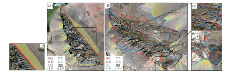
图 3 研究区一Jargalant Nuruu山系及周缘地区水系分布及沉积响应图
Fig. 3. Drainage distribution and sedimentary response of Jargalant Nuruu mountain system and its surrounding areas in the study area
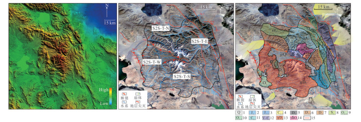
图 4 研究区二Turgen-Kharkhiraa山系及周缘地区卫星数字高程图、源区岩性、水系及其沉积响应图
1.第四纪松散堆积物,以冰碛物为主;2~3.侏罗纪陆相碎屑岩;4~10.奥陶纪‒石炭纪浅海相碎屑岩、火山岩及火山碎屑岩等;11~12.文德期‒寒武系碳酸盐岩;13.中泥盆世花岗质侵入岩;14.中奥陶世花岗闪长岩;15.断层
Fig. 4. Digital elevation map of Turgen-Kharkhiraa mountain system and its surrounding areas, lithology, drainage system and sedimentary response map of source area
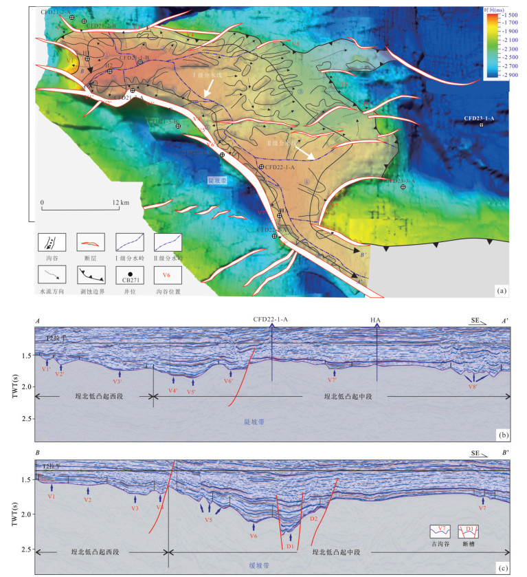
图 5 渤海湾盆地埕北低凸起古近系物源体系与搬运通道分布(据胡贺伟等,2020)
Fig. 5. Paleogene provenance system and transport channel distribution in Chengbei low uplift, Bohai Bay basin (according to Hu et al., 2020)
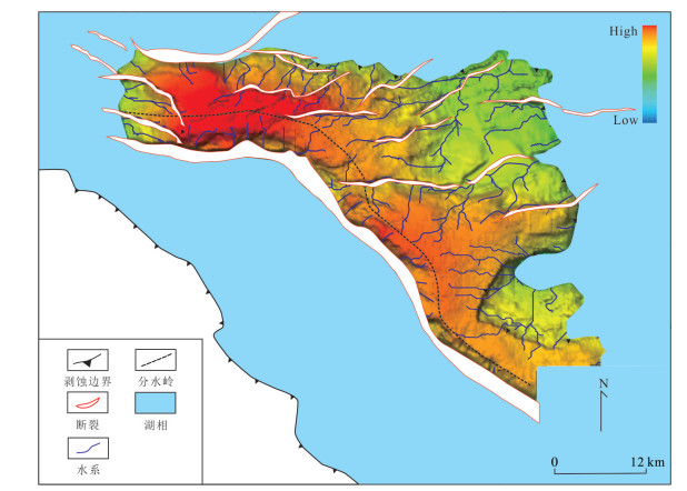
图 6 渤海湾盆地埕北低凸起沙三段水系拾取及其沉积体响应特征
Fig. 6. Drainage pickup and sedimentary response characteristics of the third member of Shahejie Formation in Chengbei low uplift, Bohai Bay basin
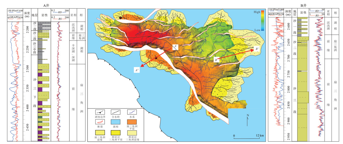
图 7 渤海湾盆地埕北低凸起沙三段水系拾取及其沉积体响应特征
Fig. 7. Drainage pickup and sedimentary response characteristics of the third member of Shahejie Formation in Chengbei low uplift, Bohai Bay basin
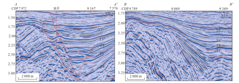
图 8 渤海湾盆地埕北低凸起沙三段沉积体地震反射特征
Fig. 8. Seismic reflection characteristics of sedimentary bodies in the third member of Shahejie Formation in Chengbei low uplift, Bohai Bay basin
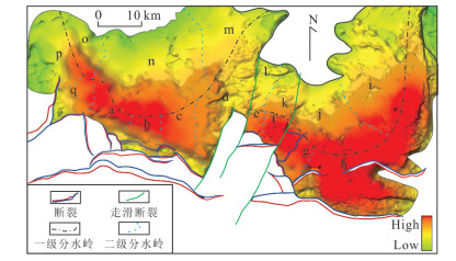
图 9 渤海湾盆地渤南低凸起孔店组古地貌恢复图
Fig. 9. Paleogeomorphology restoration of Kongdian Formation in Bonan low uplift, Bohai Bay basin

图 10 渤海湾盆地渤南低凸起孔店组岩屑分布及岩性地貌恢复图
Fig. 10. Debris distribution and lithology and geomorphology recovery of Kongdian Formation in Bonan low uplift, Bohai Bay basin
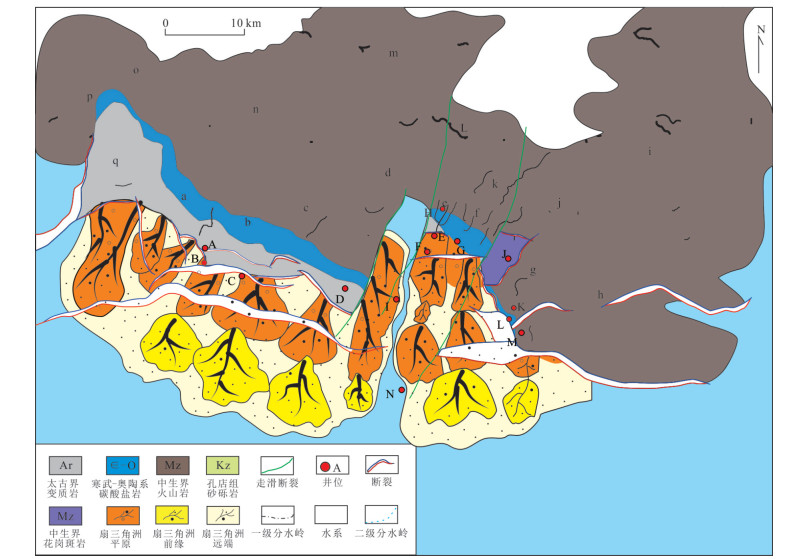
图 11 渤海湾盆地渤南低凸起孔店组古水系拾取及沉积相耦合图
Fig. 11. Paleo-drainage collection and sedimentary facies coupling of Kongdian Formation in Bonan low uplift, Bohai Bay basin
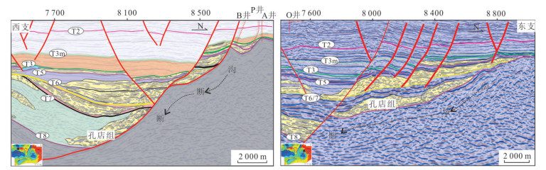
图 12 渤海湾盆地渤南低凸起孔店组地震格架沉积充填剖面
Fig. 12. Seismic lattice sedimentary filling section of Kongdian Formation in Bonan low uplift, Bohai Bay basin
表 1 蒙古西部Mt.Jargalant及Mt.Bumbat现代源汇系统参数统计表
Table 1. Statistics of modern source-sink system parameters of Mt.Jargalant and Mt.Bumbat in western Mongolia
源汇系统 子系统 源 渠 汇 整体 母岩类型 流域面积(km2) 通道编号 主水道长度(m) 出口宽度(m) 出口类型 弯曲系数 河网发育系数 坡降 沉积体面积(km2) 边界样式 S2S-J S2S-J-N 碳酸盐岩、火山岩 41.28 / / / / / / / / 191 断裂缓坡 S2S-J-W 火山岩、侵入岩 317.05 5.49 JW-1 5 461 33.76 V 1.33 0.88 8.83° 457 18.43 断裂陡坡 4.45 JW-2 2 697 54.32 V 1.11 1.46 11.63° / 9.29 JW-3 6 238 61.51 V 1.33 1.3 10.48° / 38.94 JW-4 12 580 275.67 U 1.10 2.44 7.43° 73.68 28.45 JW-5 8 154 213.6 U 1.06 2.56 10.60° 57.03 5.17 JW-6 3 777 64.14 V 1.05 0.97 12.38° / 39.68 JW-7 10 710 88.04 V 1.40 2.54 10.37° 68.23 38.29 JW-8 12 540 112.22 V 1.07 1.13 7.57° 38.83 10.29 JW-9 9 574 62.96 V 1.15 0.32 10.00° / 5.68 JW-10 4 384 63.49 U 1.14 1.26 12.94° 14.68 34.77 JW-11 9 219 137.56 U 1.08 2.21 9.36° 62.62 S2S-J-S 碎屑岩、碳酸盐岩 103.30 17.98 JS-1 9 293 35.83 V 1.08 0.37 7.61° 187 / 3.27 JS-2 5 917 37.65 V 1.06 0.23 8.69° / 稳定斜坡(陡) 9.72 JS-3 6 631 42.52 V 1.07 0.64 9.69° / 10.19 JS-4 7 922 67.55 V 1.13 1.05 9.69° / 5.93 JS-5 5 457 37.19 V 1.19 0.67 10.48° / 3.88 JS-6 4 929 52.74 V 1.38 0.50 10.19° / 7.62 JS-7 9 094 40.35 V 1.22 0.42 8.01° / 9.80 JS-8 7 946 22.69 V 1.09 0.59 6.13° 15.54 2.89 JS-9 4 360 34.18 V 1.04 / 6.92° 3.15 1.99 JS-10 2 661 45.06 V 1.10 0.19 8.98° 3.92 2.29 JS-11 2 592 46.80 V 1.04 0.23 8.18° / S2S-J-E 火山岩 140.25 0.60 JE-1 1 644 28.38 V 1.04 / 13.60° 沉积总规模:1 027 km2;近缘沉积体:306 km2;远源沉积体:721 km2 断裂陡坡 5.36 JE-2 3 031 41.13 W 1.12 1.13 13.27° 6.92 JE-3 3 572 188.43 W 1.03 1.08 12.71° 1.90 JE-4 2 277 41.28 V 1.11 / 14.17° 1.31 JE-5 1 880 32.85 V 1.04 / 14.52° 2.38 JE-6 2 292 89.71 U 1.18 / 18.19° 3.63 JE-7 3 266 71.67 U 1.19 0.92 16.61° 1.86 JE-8 2 848 65.37 U 1.19 / 19.28° 2.03 JE-9 3 693 96.36 U 1.09 / 18.32° 3.71 JE-10 3 671 78.32 U 1.18 0.29 16.68° 3.29 JE-11 3 805 57.66 U 1.13 / 19.33° 5.23 JE-12 3 796 70.24 U 1.11 / 15.14° 9.12 JE-13 3 731 44.42 V 1.09 0.80 13.42° 5.03 JE-14 3 847 87.09 W 1.09 0.60 14.45° 7.09 JE-15 4 393 243.51 U 1.05 0.26 11.37° 3.16 JE-16 3 101 116.52 W 1.08 0.57 14.80° 10.15 JE-17 4 255 251.62 U 1.06 2.70 12.64° 2.85 JE-18 2 571 68.33 V 1.04 / 14.39° 4.21 JE-19 3 658 125.31 U 1.10 0.34 13.68° 21.73 JE-20 10 220 214.35 U 1.20 1.27 7.54° 源汇系统 子系统 源 渠 汇 整体 母岩类型 流域面积(km²) 通道编号 主水道长度(m) 出口宽度(m) 弯曲系数 河网发育系数 坡降 沉积体面积(km²) 边界样式 S2S-B S2S-B-W 火山岩、侵入岩 187.93 4.64 BW-1 5 164 50.09 1.09 0.22 8.54° 395 40.65 断裂陡坡 38.04 BW-2 13 010 152.60 1.21 1.38 6.22° 1.71 BW-3 2 271 24.90 1.11 / 11.49° 9.25 BW-4 5 456 81.85 1.05 1.30 11.81° 11.16 15.57 BW-5 9 732 78.36 1.40 1.09 10.18° / 1.81 BW-6 5 676 52.02 1.13 / 8.77° / 31.35 BW-7 12 420 140.54 1.28 1.53 8.05° 27.48 7.28 BW-8 10 400 51.36 1.07 0.29 7.97° / 2.56 BW-9 9 838 34.33 1.04 / 7.75° 14.89 11.47 BW-10 8 603 57.70 1.07 1.01 10.17° / 19.45 BW-11 8 029 126.90 1.33 1.49 10.72° / 10.09 BW-12 5 842 33.72 1.10 1.61 11.02° / 13.08 BW-13 6 299 50.10 1.08 1.30 9.12° / 3.98 BW-14 4 013 44.65 1.02 0.45 12.36° / 5.28 BW-15 3 515 39.60 1.04 1.91 12.45° 54.19 3.48 BW-16 3 069 31.24 1.14 1.10 11.77° S2S-B-E 火山岩、侵入岩 435.43 8.92 BE-1 8 688 116.86 1.13 0.41 4.37° 1 396 / 断裂陡坡 5.13 BE-2 4 373 45.10 1.12 1.25 7.20° / 10.89 BE-3 7 514 53.48 1.18 1.23 5.48° / 123.37 BE-4 21 590 152.64 1.29 2.94 3.68° 297.33 31.82 BE-5 16 960 8.76 1.34 1.40 3.77° / 81.42 BE-6 18 310 91.39 1.17 1.73 4.17° 308.23 S2S-B-S 火山岩、侵入岩 29.91 BS-3 13 550 49.94 1.05 2.58 3.11° 38.14 缓坡  下载: 导出CSV
表 2 蒙古西部Mt.Turgen-Kharkhiraa现代源汇系统参数统计表
Table 2. Statistics of modern source-sink system parameters of Mt. Turgen-Kharkhiraa in western Mongolia
源汇系统 子系统 源 渠 汇 整体 母岩类型 流域面积(km²) 通道编号 主水道长度(m) 出口宽度(m) 出口类型 弯曲系数 河网发育系数 坡降 沉积体面积(km²) 边界样式 S2S-T S2S-T-N 碎屑岩 271.73 13.17 TN-1 5 851 96.33 中型沟谷 1.05 1.24 7.13° 119 10.45 稳定斜坡(陡) 33.83 TN-2 12 580 81.62 大型沟谷 1.24 1.43 5.86° 31.67 54.77 TN-3 13 910 83.23 大型沟谷 1.13 1.58 4.24° 19.91 S2S-T-W 侵入岩、碎屑岩 877.29 320.98 TW-1 32 730 189.80 大型河谷 1.09 3.11 1.97° 622 265.03 断裂缓坡 72.17 TW-2 22 270 68.50 大型沟谷 1.12 1.17 3.63° / 14.20 TW-3 13 160 64.23 大型沟谷 1.14 0.74 3.62° 12.55 20.51 TW-4 13 610 31.92 大型沟谷 1.06 1.02 4.76° 25.19 39.32 TW-5 10 060 36.54 大型沟谷 1.10 1.77 5.54° / 273.54 TW-6 29 510 116.23 大型沟谷 1.05 0.46 2.37° 5.88 S2S-T-S 侵入岩 2 177.51 685.93 TS-1 62 140 116.23 大型河谷 1.33 3.56 1.86° 314 49.62 稳定斜坡(缓) 77.10 TS-2 21 390 74.90 大型沟谷 1.16 1.31 4.47° 10.17 424.90 TS-3 41 930 490.12 大型河谷 1.09 3.13 1.93° 198.85 S2S-T-E 碎屑岩、碳酸盐岩 2 429.59 727.85 TE-1 54 380 201.82 大型河谷 1.22 2.49 2.09° 2 638 482.95 断裂陡坡 44.49 TE-2 16 980 63.24 大型沟谷 1.31 0.37 5.70° 22.13 25.23 TE-3 11 760 164.07 大型沟谷 1.04 0.36 7.50° 31.65 37.68 TE-4 9 620 97.37 大型沟谷 1.19 1.53 6.95° 41.96 657.71 TE-5 52 440 194.78 大型河谷 1.17 2.37 2.49° 918.52 41.69 TE-6 13 750 95.45 大型沟谷 1.14 0.23 3.16° 45.95 224.32 TE-7 27 300 107.04 大型沟谷 1.13 2.31 2.43° 279.76
下载: 导出CSV
-
Cai, J., 2011. Reconstruction and Evolution of Paleogene Geomorphology in the Overlap Fault Belt in the South of Nanyang Sag. Special Oil & Gas Reservoirs, 18(6): 57-60, 126 (in Chinese with English abstract). Cao, H. X., Wu, H. Y., Ren, X. M., et al., 2020. Karst Paleogeomorphology and Reservoir Distribution Pattern of Ordovician in the Southeastern Ordos Basin. China Petroleum Exploration, 25(3): 146-155 (in Chinese with English abstract). Chen, L. X., Li, H. Y., Dai, L. M., et al., 2016. Characteristics of Ancient Valleys and Ancient Slope Break in the Fenced Area of Chengbei Low Uplift and Its Control over the Depositional System. Journal of Yangtze University (Natural Science Edition), 13(5): 15-19 (in Chinese with English abstract). Cunningham, D., 2005. Active Intracontinental Transpressional Mountain Building in the Mongolian Altai: Defining a New Class of Orogen. Earth and Planetary Science Letters, 240(2): 436-444. https://doi.org/10.1016/j.epsl.2005.09.013 Cunningham, W. D., Windley, B. F., Dorjnamjaa, D., et al., 1996. A Structural Transect across the Mongolian Western Altai: Active Transpressional Mountain Building in Central Asia. Tectonics, 15(1): 142-156. https://doi.org/10.1029/95tc02354 Dai, J. Y., Mu, Z. Q., Wang, Y. L., et al., 2018. Study on Ordovician Karst Palaeogeomorphology in Shan 330 Area in Jingbian Gasfield. Petrochemical Industry Application, 37(3): 116-121 (in Chinese with English abstract). Duan, J. X., Dong, Y. P., Wu, K., et al., 2021. Characteristics of River Networks in the Central Yunnan Province and Their Responses to Tectonic Activities. Geotectonica et Metallogenia, 45(2): 296-307 (in Chinese with English abstract). Fu, X. Y., Yang, Y., Huang, Y. G., et al., 2014. Palaeomorphologic Reconstruction of Ordovician Karst in Southern Sulige Gasfield and Its Effect on Reservoir Distribution. Natural Gas Exploration and Development, 37(3): 1-4 (in Chinese with English abstract). Gong, Y. W., Gao, H. D., 2016. Study on Surface Drainage Structure Characteristics of Typical Metamorphic Rock Area in Guizhou Province. Soil and Water Conservation in China, (2): 57-61 (in Chinese with English abstract). Guo, T., Li, H. Y., Shi, W. L., et al., 2015. Tectonic-Sedimentary Characteristics and Favorable Exploration Targets in the Chengbei Low Uplift and Neighboring Regions in Bohai Sea Area. Petroleum Geology and Recovery Efficiency, 22(2): 28-32, 38 (in Chinese with English abstract). Hu, H. W., Li, H. Y., Yu, H. B., et al., 2020. Quantitative Analysis of Source-to-Sink System Controls on Sand-Body Distribution of the Paleogene in Chengbei Low Uplift and Surrounding Areas, Bohai Bay Basin. Journal of Palaeogeography, 22(2): 266-277 (in Chinese with English abstract). Jiang, G., Cao, G. C., Cao, S. K., et al., 2013. Drainage System Simulation of Qinghai Lake Basin Based on ArcGIS and DEM. Journal of Suzhou University, 28(9): 80-84 (in Chinese with English abstract). Jiang, N., 2014. A Preliminary Discussion of the Development Characteristics of the Palaeogene Gully in Huanghekou Sag, China (Dissertation). China University of Geosciences, Beijing (in Chinese with English abstract). Li, J. Q., 2008. Application of Layering Technique to Paleogeomorphology Restoration before Deposition: A Case Study of Dongying Area in Jiyang Depression. Journal of Shengli Oilfield Staff University, 22(1): 31-32, 36 (in Chinese with English abstract). Li, S., 2020. "Source-Sink-Diagenesis-Reservoir" Integrated High-Quality Mixed-Siliciclastic-Carbonate Reservoir Prediction of Paleogene Mixed Sediments in Huanghekou Sag, Bohai Bay Basin, China (Dissertation). China University of Geosciences, Wuhan (in Chinese with English abstract). Li, Z. Y., Liu, Q. H., Zhu, H. T., et al., 2021. Compositional Relationship between the Source-to-Sink Segments and Their Sedimentary Response to Diverse Geomorphology Types in the Intrabasinal Lower Uplift of Continental Basins. Marine and Petroleum Geology, 123: 104716. https://doi.org/10.1016/j.marpetgeo.2020.104716 Liu, H., Tian, L. X., Zhou, X. H., et al., 2017. Slope Break Systems of Rift Lacustrine Basin and Erosion-Depositional Response: A Case Study of the Paleogene in Huanghekou Sag, Bohai Sea. China Offshore Oil and Gas, 29(4): 28-38 (in Chinese with English abstract). Liu, Q. H., 2016. "Source-to-Sink" System Coupling Analysis of the Paleogene, Shaleitian Uplift, Bohai Bay Basin, China (Dissertation). China University of Petroleum, Beijing (in Chinese with English abstract). Liu, Y. T., Liu, C. Y., Zhou, Y. J., et al., 2019. Palaeo- Geomorphology Restoration with Double-Interface Seismic Layer Leveling: An Example of Tianhuan Depression in Ordos Basin. Oil Geophysical Prospecting, 54(3): 656-666, 489 (in Chinese with English abstract). Lu, W. Y., Zhu, H. T., Xu, C. G., et al., 2020. Methods and Applications of Level Subdivision of Source-to-Sink System. Earth Science, 45(4): 1327-1336 (in Chinese with English abstract). Nie, G. Q., Tan, Y., Xu, L., et al., 2020. Characteristics and Characterization of Karst Paleo-Geomorphology and Paleo-Water System on the Top of the Maokou Formation in the Z Area in Southern Sichuan Basin. Carsologica Sinica, 39(6): 911-917 (in Chinese with English abstract). Rudnev, S. N., Izokh, A. E., Borisenko, A. S., et al., 2016. Granitoid Magmatism and Metallogeny of the Lake Zone in Western Mongolia (by the Example of the Bumbat-Hairhan Area). Russian Geology & Geophysics, 57(2): 207-224. https://doi.org/10.1016/j.rgg.2016.02.001 Tapponnier, P., Molnar, P., 1979. Active Faulting and Cenozoic Tectonics of the Tienshan, Mongolia and Baykal Regions. Journal of Geophysical Research, 84(B7): 3425-3459. https://doi.org/10.1029/jb084ib07p03425 Walker, R. T., Bayasgalan, A., Carson, R., et al., 2003. Geomorphology and Structure of the Jid Right-Lateral Strike-Slip Fault in the Mongolian Altay Mountains. Journal of Structural Geology, 28(9): 1607-1622. https://doi.org/10.1016/j.jsg.2006.04.007 Wang, J. G., Jiang, C. J., Chang, S., et al., 2017. Structural Trend Surface Conversion Method for Micro-Amplitude Paleotopographic Restoration of Cratonic Basins. Acta Petrolei Sinica, 38(1): 77-83, 104 (in Chinese with English abstract). Yan, H. J., Peng, X., Xia, Q. Y., et al., 2020. Distribution Features of Ancient Karst Landform in the Fourth Member of the Dengying Formation in the Gaoshiti-Moxi Region and Its Guiding Significance for Gas Reservoir Development. Acta Petrolei Sinica, 41(6): 658-670, 752 (in Chinese with English abstract). Yang, C., Zhu, H. T., Niu, C. M., et al., 2021. Characteristics and Models of Shallow-Water Environmental River-Lake Interaction in Continental Basins. Earth Science, 46(5): 1771-1782 (in Chinese with English abstract). Yin, K. J., 1991. The Relations between the Stretch of River System and Fault Activity. South China Journal of Seismology, 11(1): 41-45 (in Chinese with English abstract). Zhan, X. G., Zhao, J. S., Ouyang, T. Z., et al., 2016. Paleogeomorphic Reconstruction in the Permian Maokou Age in the Puguang Area, Northeast Sichuan. Acta Geologica Sichuan, 36(2): 210-212 (in Chinese with English abstract). Zhang, J., 2015. Based on Multi-Source Data of Remote Sensing Geological Structure Interpretation (Dissertation). Chang'an University, Xi'an (in Chinese with English abstract). Zhao, Q., Zhu, H., Zhang, X., et al., 2021. Geomorphologic Reconstruction of an Uplift in a Continental Basin with a Source-to-Sink Balance: An Example from the Huizhou-Lufeng Uplift, Pearl River Mouth Basin, South China Sea. Marine and Petroleum Geology, 128: 104984. https://doi: 10.1016/j.marpetgeo.2021.104984 Zhou, G. Y., Hou, Z. H., 2014. Experimental Study on DEM Extraction in Fenhe River. Sci-Tech Innovation and Productivity, (11): 60-63 (in Chinese with English abstract). Zhou, Y. C., Yao, G. M., Wei, H. H., et al., 2020. Classification and Identification of Karst Palaeogeomorphology and Prediction of Favorable Areas in Southern Yan'an Gas Field, Ordos Basin. Special Oil & Gas Reservoirs, 27(6): 102-107 (in Chinese with English abstract). Zhu, M., Shen, A. J., Zeng, H. L., et al., 2018. The Application of Paleogeomorphy Restoration to the Study of Karst Weathering Crust Reservoir: A Case from the Fourth Member of Dengying Formation in Moxi Area, Sichuan Basin. Marine Origin Petroleum Geology, 23(4): 87-95 (in Chinese with English abstract). 蔡佳, 2011. 南阳凹陷南部断超带古近系古地貌恢复及演化. 特种油气藏, 18(6): 57-60, 126. https://www.cnki.com.cn/Article/CJFDTOTAL-TZCZ201106015.htm 曹红霞, 吴海燕, 任星民, 等, 2020. 鄂尔多斯盆地东南部奥陶系岩溶古地貌与储层分布规律. 中国石油勘探, 25(3): 146-155. https://www.cnki.com.cn/Article/CJFDTOTAL-KTSY202003013.htm 陈丽祥, 李慧勇, 代黎明, 等, 2016. 埕北低凸起围区古沟谷与古坡折带特征及其对沉积体系的控制作用. 长江大学学报(自然科学版), 13(5): 15-19. https://www.cnki.com.cn/Article/CJFDTOTAL-CJDL201605003.htm 代金友, 穆中奇, 王永林, 等, 2018. 靖边气田陕330井区奥陶纪喀斯特古地貌研究. 石油化工应用, 37(3): 116-121. https://www.cnki.com.cn/Article/CJFDTOTAL-NXSH201803034.htm 段佳鑫, 董有浦, 吴可, 等, 2021. 滇中河网特征及其对断层活动的响应. 大地构造与成矿学, 45(2): 296-307. https://www.cnki.com.cn/Article/CJFDTOTAL-DGYK202102004.htm 付晓燕, 杨勇, 黄有根, 等, 2014. 苏里格南区奥陶系岩溶古地貌恢复及对气藏分布的控制作用. 天然气勘探与开发, 37(3): 1-4. https://www.cnki.com.cn/Article/CJFDTOTAL-TRKT201403002.htm 龚羿文, 高华端, 2016. 贵州省典型变质岩地区地表水系结构特征研究. 中国水土保持, (2): 57-61. https://www.cnki.com.cn/Article/CJFDTOTAL-ZGSB201602020.htm 郭涛, 李慧勇, 石文龙, 等, 2015. 渤海海域埕北低凸起及周围地区构造沉积特征与有利勘探目标. 油气地质与采收率, 22(2): 28-32, 38. https://www.cnki.com.cn/Article/CJFDTOTAL-YQCS201502005.htm 胡贺伟, 李慧勇, 于海波, 等, 2020. 渤海湾盆地埕北低凸起及围区古近系"源‒汇" 系统控砂原理定量分析. 古地理学报, 22(2): 266-277. https://www.cnki.com.cn/Article/CJFDTOTAL-GDLX202002005.htm 蒋刚, 曹广超, 曹生奎, 等, 2013. 基于ArcGIS与DEM的青海湖流域水系模拟. 宿州学院学报, 28(9): 80-84. https://www.cnki.com.cn/Article/CJFDTOTAL-SZSY201309024.htm 姜楠, 2014. 黄河口凹陷古近系沟谷发育特征初探(硕士学位论文). 北京: 中国地质大学. 李家强, 2008. 层拉平技术在沉积前古地貌恢复中的应用: 以济阳坳陷东营地区为例. 胜利油田职工大学学报, 22(1): 31-32, 36. https://www.cnki.com.cn/Article/CJFDTOTAL-YTZD200801019.htm 李森, 2020. 渤海湾盆地黄河口凹陷古近系混积岩"源‒汇‒岩‒储"一体化优质储层预测(博士学位论文). 武汉: 中国地质大学. 刘豪, 田立新, 周心怀, 等, 2017. 断陷湖盆坡折体系与剥蚀沉积响应: 以黄河口凹陷古近系为例. 中国海上油气, 29(4): 28-38. https://www.cnki.com.cn/Article/CJFDTOTAL-ZHSD201704004.htm 刘强虎, 2016. 渤海湾盆地沙垒田凸起古近系"源‒渠‒汇"系统耦合研究(博士学位论文). 北京: 中国石油大学. 刘永涛, 刘池洋, 周义军, 等, 2019. 双界面地震层拉平的古地貌恢复技术及应用: 以鄂尔多斯盆地天环坳陷为例. 石油地球物理勘探, 54(3): 656-666, 489. https://www.cnki.com.cn/Article/CJFDTOTAL-SYDQ201903020.htm 陆威延, 朱红涛, 徐长贵, 等, 2020. 源‒汇系统级次划分方法及应用. 地球科学, 45(4): 1327-1336. doi: 10.3799/dqkx.2019.123 聂国权, 淡永, 徐亮, 等, 2020. 蜀南Z工区茅口组顶岩溶古地貌、古水系特征与刻画. 中国岩溶, 39(6): 911-917. https://www.cnki.com.cn/Article/CJFDTOTAL-ZGYR202006014.htm 王建国, 蒋传杰, 常森, 等, 2017. 克拉通盆地微古地貌恢复的构造趋势面转换法. 石油学报, 38(1): 77-83, 104. https://www.cnki.com.cn/Article/CJFDTOTAL-SYXB201701008.htm 闫海军, 彭先, 夏钦禹, 等, 2020. 高石梯‒磨溪地区灯影组四段岩溶古地貌分布特征及其对气藏开发的指导意义. 石油学报, 41(6): 658-670, 752. https://www.cnki.com.cn/Article/CJFDTOTAL-SYXB202006004.htm 杨超, 朱红涛, 牛成民, 等, 2021. 陆相盆地浅水背景河湖交互特征及其模式. 地球科学, 46(5): 1771-1782. doi: 10.3799/dqkx.2020.178 尹克坚, 1991. 水系展布方式与断裂活动程度的关系. 华南地震, 11(1): 41-45. https://www.cnki.com.cn/Article/CJFDTOTAL-HNDI199101009.htm 占小刚, 赵俊省, 欧阳甜子, 等, 2016. 川东北普光地区二叠系茅口组古地貌恢复研究. 四川地质学报, 36(2): 210-212. https://www.cnki.com.cn/Article/CJFDTOTAL-SCDB201602007.htm 张健, 2015. 基于多源数据的遥感地质构造解译(硕士学位论文). 西安: 长安大学. 周国园, 侯志华, 2014. 基于DEM的汾河流域水系提取试验研究. 科技创新与生产力, (11): 60-63. https://www.cnki.com.cn/Article/CJFDTOTAL-TAIY201411029.htm 周宇成, 姚光明, 魏荷花, 等, 2020. 鄂尔多斯盆地延安气田南部岩溶古地貌分级识别及有利区预测. 特种油气藏, 27(6): 102-107. https://www.cnki.com.cn/Article/CJFDTOTAL-TZCZ202006014.htm 朱茂, 沈安江, 曾洪流, 等, 2018. 古地貌恢复在岩溶风化壳储层研究中的应用: 以川中磨溪地区灯影组四段为例. 海相油气地质, 23(4): 87-95. https://www.cnki.com.cn/Article/CJFDTOTAL-HXYQ201804010.htm -

 点击查看大图
计量
- 文章访问数: 976
- HTML全文浏览量: 777
- PDF下载量: 90
- 被引次数: 0
