


Land Surface Soil Moisture along Sichuan-Tibet Traffic Corridor Retrieved by Spaceborne Global Navigation Satellite System Reflectometry
-
摘要: 地表土壤湿度影响着陆-气能量交换和水循环,是泥石流、冻土冻融等灾害的重要因子,获取川藏交通廊道沿线地区土壤湿度有助于研究铁路沿线气候变化和冰冻圈灾害风险.基于CYGNSS(cyclone global navigation satellite system)星载GNSS-R(global navigation satellite system reflectometry)信号,结合土地覆盖分类、归一化差分植被指数NDVI(normalized differential vegetation index)和粗糙度等地表土壤湿度影响因子,利用人工神经网络方法建立了地表土壤湿度多参数反演模型,生成了2018—2019年连续两年的川藏交通廊道沿线地区36 km空间分辨率的地表土壤湿度日产品.经土壤水分主被动探测卫星数据检验,生成的地表土壤湿度相关系数R为0.8,均方根误差RMSE(root mean square error)为0.032 cm3/cm3,偏差Bias为0.014 cm3/cm3,可为川藏交通廊道沿线气候变化和地表灾害研究提供高连续性和可靠性的数据.Abstract: Land surface soil moisture affects the land-air energy exchange and the water cycle, which is an important factor for geohazards such as debris flow and freeze-thaw of permafrost. Obtaining soil moisture along the Sichuan-Tibet traffic corridor corridor contributes to study climate change and the risk of cryospheric hazards along the railway. In this study, CYGNSS(cyclone global navigation satellite system) GNSS-R(global navigation satellite system reflectometry) signals, combined with land cover, normalized differential vegetation index (NDVI), land surface roughness, and other surface soil moisture influencing factors, are taken as input parameters to the artificial neural network method to establish a multi-parameter inversion model of surface soil moisture. Then it generates a daily product of surface soil moisture with a spatial resolution of 36 km in the area along the Sichuan-Tibet railway for two consecutive years from 2018 to 2019. With soil moisture active and passive (SMAP) soil moisture as references, the correlation coefficient R of the soil moisture is 0.8, the root mean square error (RMSE) is 0.032 cm3/cm3, and the Bias is 0.014 cm3/cm3. The soil moisture products could provide continuous and reliable data for the study of climate change and land surface hazards along the Sichuan-Tibet traffic corridor.
-
Key words:
- surface soil moisture /
- Sichuan-Tibet traffic corridor /
- CYGNSS /
- GNSS-R /
- artificial neural network /
- remote sensing
-

图 1 研究区域(a)、川藏交通廊道沿线地形剖面(b)及2018年SMAP土壤湿度分布(c)
图中黑色线条表示川藏交通廊道;a图红色三角表示Naqu观测站网;b图横轴表示到成都的距离;c图空白处表示无SMAP土壤湿度数据
Fig. 1. The study area (a) and topography along Sichuan-Tibet traffic corridor (b) and the surface soil moisture distribution derived from SMAP in 2018 (c)
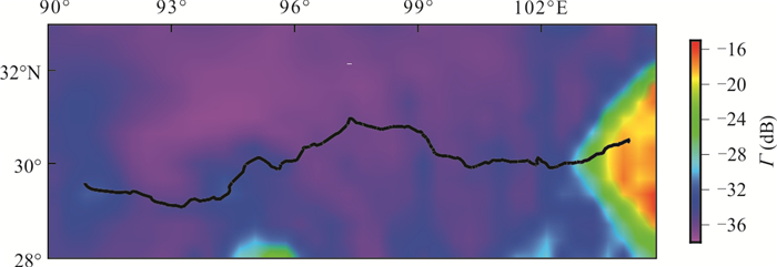
图 2 2018年川藏交通廊道沿线地区CYGNSS地表反射率
Fig. 2. CYGNSS-derived surface reflectivity along Sichuan-Tibet traffic corridor in 2018
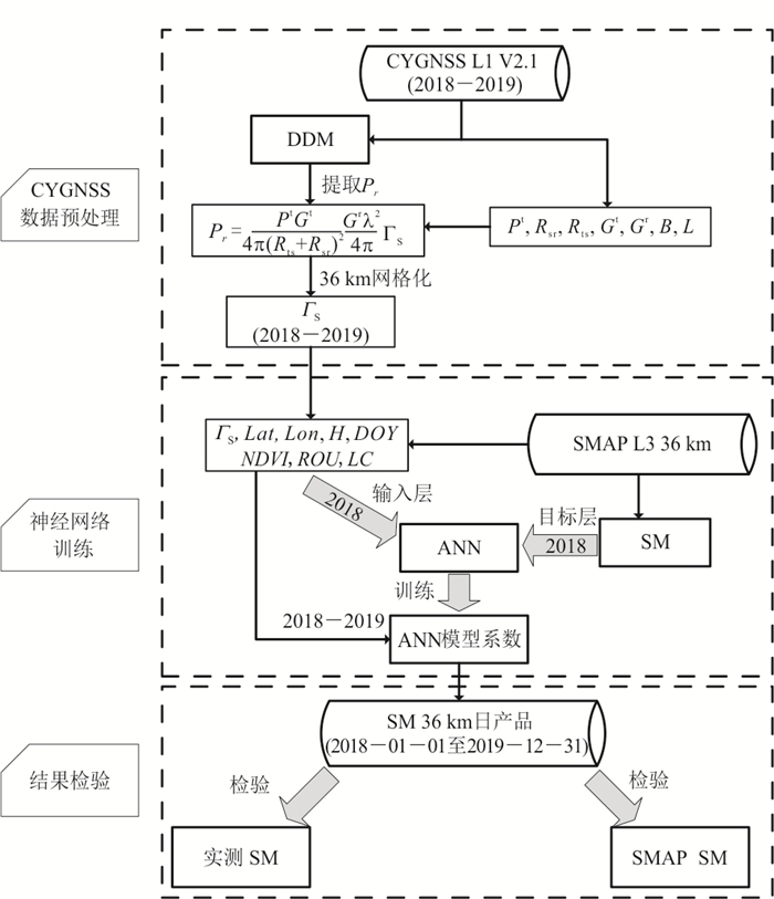
图 3 川藏交通廊道沿线地区地表土壤湿度反演流程
Fig. 3. Flow chart of the retrieval process of surface soil moisture along Sichuan-Tibet traffic corridor

图 4 2019年6月14日和6月15日川藏交通廊道沿线地区CYGNSS SM和SMAP SM分布
Fig. 4. Distributions of CYGNSS SM and SMAP SM in the area along the Sichuan-Tibet traffic corridor on 14-15 June, 2019

图 5 2018年CYGNSS SM与SMAP相比相关系数R (a)、RMSE (b)和Bias (c)分布
Fig. 5. Distributions of the correlation coefficient, RMSE, and Bias of CYGNSS SM against SMAP SM in 2018
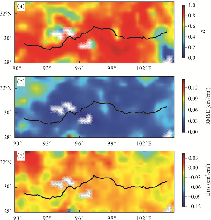
图 6 2019年CYGNSS SM与SMAP相比相关系数RMSE和Bias分布
Fig. 6. Distributions of the correlation coefficient, RMSE, and Bias of CYGNSS SM against SMAP SM in 2018
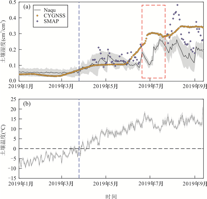
图 7 2019年3种地表土壤湿度数据的时间序列(a)及对应的地表温度(b)
灰色阴影为1倍标准差,蓝色虚线标示出冻结/融化分界(即地表温度大于0°),红色虚线矩形框表示SMAP SM数据缺失时间段(2019-06-20至2019-07-22)
Fig. 7. Time series of three kinds of surface soil moisture data (a) and corresponding surface temperatures (b) in 2019

图 8 2019年Naqu观测站网CYGNSS SM和SMAP SM散点图
黄色和蓝色虚线分别表示CYGNSS SM、SMAP SM与Naqu实测数据的线性拟合结果
Fig. 8. Scatter plots of CYGNSS SM and SMAP SM vs. Naqu in situ data in 2019
表 1 CYGNSS L1级2.1版本产品主要参量
Table 1. Key variables of CYGNSS level 1 products (version 2.1)
变量符号 变量名 单位 说明 P power_analog watt DDM功率 $ {P}^{\mathrm{t}} $ gps_tx_power_db_w dB GPS信号发射功率 $ {R}_{\mathrm{s}\mathrm{r}} $ rx_to_sp_range m CYGNSS卫星到镜面反射点距离 $ {R}_{\mathrm{t}\mathrm{s}} $ tx_to_sp_range m GPS卫星到镜面反射点距离 $ {G}^{t} $ gps_ant_gain_db_i dBi GPS信号发射天线增益 $ {\mathrm{G}}^{\mathrm{r}} $ sp_rx_gain dBi CYGNSS反射信号接收天线增益 B sp_lat 度 镜面反射点纬度 L sp_lon 度 镜面反射点经度 $ \theta $ sp_inc_angle 度 镜面反射点入射角  下载: 导出CSV
表 2 使用的Naqu观测站网信息
Table 2. Information of the Naqu observation network used in this study
站点编号 纬度(°) 经度(°) 高程(m) 测量深度(cm) NQ01 31.326 91.829 4 517.00 5.000 NQ02 31.309 91.820 4 552.00 5.000 NQ03 31.278 91.789 4 638.00 5.000 NQ04 31.257 91.804 4 632.00 5.000
下载: 导出CSV
表 3 与SMAP SM相比本文获取的CYGNSS SM精度统计
Table 3. Precision statistics of CYGNSS SM compared with SMAP SM
相关系数R RMSE(cm3/cm3) Bias(cm3/cm3) 2018年(训练期) 0.857 0.030 0.016 2019年(预测期) 0.743 0.034 0.010 2018—2019年 0.800 0.032 0.014
下载: 导出CSV
-
Al-Khaldi, M. M., Johnson, J. T., 2022. Soil Moisture Retrievals Using CYGNSS Data in a Time-Series Ratio Method: Progress Update and Error Analysis. IEEE Geoscience and Remote Sensing Letters, 19: 1-5. https://doi.org/10.1109/lgrs.2021.3086092 Camps, A., Park, H., Pablos, M., et al., 2016. Sensitivity of GNSS-R Spaceborne Observations to Soil Moisture and Vegetation. IEEE Journal of Selected Topics in Applied Earth Observations and Remote Sensing, 9(10): 4730-4742. https://doi.org/10.1109/jstars.2016.2588467 Carreno-Luengo, H., Luzi, G., Crosetto, M., 2019. Sensitivity of CyGNSS Bistatic Reflectivity and SMAP Microwave Radiometry Brightness Temperature to Geophysical Parameters over Land Surfaces. IEEE Journal of Selected Topics in Applied Earth Observations and Remote Sensing, 12(1): 107-122. https://doi.org/10.1109/jstars.2018.2856588 Chai, B., Tao, Y. Y., Du, J., et al., 2020. Hazard Assessment of Debris Flow Triggered by Outburst of Jialong Glacial Lake in Nyalam County, Tibet. Earth Science, 45(12): 4630-4639(in Chinese with English abstract). Chan, S. K., Bindlish, R., O'Neill, P. E., et al., 2016. Assessment of the SMAP Passive Soil Moisture Product. IEEE Transactions on Geoscience and Remote Sensing, 54(8): 4994-5007. https://doi.org/10.1109/TGRS.2016.2561938. Chen, H. Y., Wu, J., Li, C. B., et al., 2020. Application Evaluation of Satellite Soil Moisture Products in Qinghai-Tibet Plateau. Acta Ecologic Sinica, 40(24): 9195-9207(in Chinese with English abstract). Chen, R., Yang, X. M., Wan, G. N., et al., 2020. Soil Freezing-Thawing Processes on the Tibetan Plateau: A Review Based on Hydrothermal Dynamics. Progress in Geography, 39(11): 1944-1958(in Chinese with English abstract). doi: 10.18306/dlkxjz.2020.11.014 Chen, Y., Yang, K., Qin, J., et al., 2013. Evaluation of AMSR-E Retrievals and GLDAS Simulations against Observations of a Soil Moisture Network on the Central Tibetan Plateau. Journal of Geophysical Research: Atmospheres, 118(10): 4466-4475. https://doi.org/10.1002/jgrd.50301 Chen, Y., Yang, K., Qin, J., et al., 2017. Evaluation of SMAP, SMOS, and AMSR2 Soil Moisture Retrievals against Observations from Two Networks on the Tibetan Plateau. Journal of Geophysical Research: Atmospheres, 122: 5780-5792. doi: 10.1002/2016jd026388 Chew, C. C., Shah, R., Zuffada, C., et al., 2016. Demonstrating Soil Moisture Remote Sensing with Observations from the UK TechDemoSat-1 Satellite Mission. Geophysical Research Letters, 43(7): 3317-3324. https://doi.org/10.1002/2016gl068189 Chew, C. C., Small, E. E., 2018. Soil Moisture Sensing Using Spaceborne GNSS Reflections: Comparison of CYGNSS Reflectivity to SMAP Soil Moisture. Geophysical Research Letters, 45(9): 4049-4057. https://doi.org/10.1029/2018gl077905 Chew, C., Small, E., 2020a. Description of the UCAR/CU Soil Moisture Product. Remote Sensing, 12(10): 1558. https://doi.org/10.3390/rs12101558 Chew, C., Small, E., 2020b. Estimating Inundation Extent Using CYGNSS Data: A Conceptual Modeling Study. Remote Sensing of Environment, 246: 111869. https://doi.org/10.1016/j.rse.2020.111869 Clarizia, M. P., Pierdicca, N., Costantini, F., et al., 2019. Analysis of CYGNSS Data for Soil Moisture Retrieval. IEEE Journal of Selected Topics in Applied Earth Observations and Remote Sensing, 12(7): 2227-2235. https://doi.org/10.1109/jstars.2019.2895510. Dente, L., Su, Z. B., Wen, J., 2012. Validation of SMOS Soil Moisture Products over the Maqu and Twente Regions. Sensors (Basel, Switzerland), 12(8): 9965-9986. https://doi.org/10.3390/s120809965 Fan, K. K., Zhang, Q., Sun, P., et al., 2019. Variation, Causes and Future Estimation of Surface Soil Moisture on the Tibetan Plateau. Acta Geographica Sinica, 74(3): 520-533(in Chinese with English abstract). Foti, G., Gommenginger, C., Jales, P., et al., 2015. Spaceborne GNSS Reflectometry for Ocean Winds: First Results from the UK TechDemoSat-1 Mission. Geophysical Research Letters, 42(13): 5435-5441. https://doi.org/10.1002/2015gl064204. Jackson, T. J., Cosh, M. H., Bindlish, R., et al., 2010. Validation of Advanced Microwave Scanning Radiometer Soil Moisture Products. IEEE Transactions on Geoscience and Remote Sensing, 48(12): 4256-4272. https://doi.org/10.1109/tgrs.2010.2051035 Jing, C. L., 2020. Comparative Evaluation of SMAP & CCI & CLDAS Soil Moisture Products in Typical Region of Qinghai-Tibet Plateau. Journal of Subtropical Resources and Environment, 15(1): 85-94(in Chinese with English abstract). Kerr, Y. H., Waldteufel, P., Wigneron, J. P., et al., 2001. Soil Moisture Retrieval from Space: The Soil Moisture and Ocean Salinity (SMOS) Mission. IEEE Transactions on Geoscience and Remote Sensing, 39(8): 1729-1735. https://doi.org/10.1109/36.942551 Li, J. R., Niu, Z. G., Feng, L., et al., 2020. Simulation and Prediction of Extreme Temperature Indices in Yangtze and Yellow River Basins by CMIP5 Models. Earth Science, 45(6): 1887-1904(in Chinese with English abstract). Liu, J., Chai, L. N., Lu, Z., et al., 2019. Evaluation of SMAP, SMOS-IC, FY3B, JAXA, and LPRM Soil Moisture Products over the Qinghai-Tibet Plateau and Its Surrounding Areas. Remote Sensing, 11(7): 792. https://doi.org/10.3390/rs11070792 Liu, Q., Du, J. Y., Shi, J. C., et al., 2013. Analysis of Spatial Distribution and Multi-Year Trend of the Remotely Sensed Soil Moisture on the Tibetan Plateau. Science China: Earth Sciences, 43(10): 1677-1690(in Chinese). Mladenova, I. E., Jackson, T. J., Bindlish, R., et al., 2013. Incidence Angle Normalization of Radar Backscatter Data. IEEE Transactions on Geoscience and Remote Sensing, 51(3): 1791-1804. https://doi.org/10.1109/tgrs.2012.2205264. Peng, J. B., Cui, P., Zhuang, J. Q., 2020. Challenges to Engineering Geology of Sichuan-Tibet Railway. Chinese Journal of Rock Mechanics and Engineering, 39(12): 2377-2389(in Chinese with English abstract). Ruf, C. S., Atlas, R., Chang, P. S., et al., 2016. New Ocean Winds Satellite Mission to Probe Hurricanes and Tropical Convection. Bulletin of the American Meteorological Society, 97(3): 385-395. https://doi.org/10.1175/bams-d-14-00218.1 Su, Z., Wen, J., Dente, L., et al., 2011. The Tibetan Plateau Observatory of Plateau Scale Soil Moisture and Soil Temperature (Tibet-Obs) for Quantifying Uncertainties in Coarse Resolution Satellite and Model Products. Hydrology and Earth System Sciences, 15(7): 2303-2316. https://doi.org/10.5194/hess-15-2303-2011 Yang, C. Y., Wang, S. X., Yang, C. Y., et al., 2021. Spatial-Temporal Variation Characteristics of Vegetation Coverage along Sichuan-Tibet Railway. Journal of Arid Land Resources and Environment, 35(3): 174-182(in Chinese with English abstract). Yang, K., Qin, J., Zhao, L., et al., 2013. A Multiscale Soil Moisture and Freeze-Thaw Monitoring Network on the Third Pole. Bulletin of the American Meteorological Society, 94(12): 1907-1916. doi: 10.1175/bams-d-12-00203.1 Yao, P., Lu, H., Shi, J., et al., 2021. A Long Term Global Daily Soil Moisture Dataset Derived from AMSR-E and AMSR2 (2002—2019). Scientific Data, 8(1). https://doi.org/10.1038/s41597-021-00925-8 Zeng, J. Y., Li, Z., Chen, Q., et al., 2015. Evaluation of Remotely Sensed and Reanalysis Soil Moisture Products over the Tibetan Plateau Using In-Situ Observations. Remote Sensing of Environment, 163: 91-110. https://doi.org/10.1016/j.rse.2015.03.008. Zhang, P., Zheng, D., Wen, J., et al., 2021. A 10-Year Surface Soil Moisture Dataset Produced Based on In Situ Measurements Collected from the Tibet-Obs (2009—2019). National Tibetan Plateau Data Center, doi: 10.4121/12763700.v7 Zheng, D. H., Wang, X., van der Velde, R., et al., 2018. Impact of Surface Roughness, Vegetation Opacity and Soil Permittivity on L-Band Microwave Emission and Soil Moisture Retrieval in the Third Pole Environment. Remote Sensing of Environment, 209: 633-647. https://doi.org/10.1016/j.rse.2018.03.011. 柴波, 陶阳阳, 杜娟, 等, 2020. 西藏聂拉木县嘉龙湖冰湖溃决型泥石流危险性评价. 地球科学, 45(12): 4630-4639. doi: 10.3799/dqkx.2020.294 陈泓羽, 吴静, 李纯斌, 等, 2020. 卫星土壤水分产品在青藏高原地区的适用性评价. 生态学报, 40(24): 9195-9207. https://www.cnki.com.cn/Article/CJFDTOTAL-STXB202024033.htm 陈瑞, 杨梅学, 万国宁, 等, 2020. 基于水热变化的青藏高原土壤冻融过程研究进展. 地理科学进展, 39(11): 1944-1958. doi: 10.18306/dlkxjz.2020.11.014 范科科, 张强, 孙鹏, 等, 2019. 青藏高原地表土壤水变化、影响因子及未来预估. 地理学报, 74(3): 520-533. https://www.cnki.com.cn/Article/CJFDTOTAL-DLXB201903010.htm 荆琛琳, 2020. SMAP、CCI和CLDAS土壤湿度产品在青藏高原典型区域的比较验证. 亚热带资源与环境学报, 15(1): 85-94. doi: 10.3969/j.issn.1673-7105.2020.01.012 李佳瑞, 牛自耕, 冯岚, 等, 2020. CMIP5模式对长江和黄河流域极端气温指标的模拟与预估. 地球科学, 45(6): 1887-1904. doi: 10.3799/dqkx.2020.116 刘强, 杜今阳, 施建成, 等, 2013. 青藏高原表层土壤湿度遥感反演及其空间分布和多年变化趋势分析. 中国科学: 地球科学, 43(10): 1677-1690. https://www.cnki.com.cn/Article/CJFDTOTAL-JDXK201310012.htm 彭建兵, 崔鹏, 庄建琦, 2020. 川藏交通廊道对工程地质提出的挑战. 岩石力学与工程学报, 39(12): 2377-2389. 杨彩云, 王世曦, 杨春艳, 等, 2021. 川藏交通廊道沿线植被覆盖度时空变化特征分析. 干旱区资源与环境, 35(3): 174-182. -

 点击查看大图
计量
- 文章访问数: 1475
- HTML全文浏览量: 666
- PDF下载量: 89
- 被引次数: 0
