


Route Selection of Landslide Prone Area in Wenchuan Section of Chengdu-Wenchuan Expressway Based on SBAS-InSAR
-
摘要: 西南山区地质构造复杂导致大量的滑坡分布.为了科学有效的指导西南山区道路选线,提前规避地质灾害高风险,滑坡灾害早期识别必不可少.合成孔径雷达干涉测量(interferometric synthetic aperture radar,InSAR)技术因其全天候、多时相等特点被广泛应用于滑坡灾害的早期识别中.收集了87景Sentinel-1A降轨数据,利用差分干涉测量短基线集时序分析(small baseline subset interferometric synthetic aperture radar,SBAS-InSAR)技术对成汶高速路汶川段进行形变区的识别与分析,结果显示共识别出10处,经野外复核均为处于持续变形中的滑坡,有较好的一致性.根据早期识别结果,对3个比选方案进行综合对比分析,确定方案B为最优选择.SBAS-InSAR技术能有效识别山区公路潜在滑坡隐患区,为山区公路的准确选线提供科学依据.
-
关键词:
- 高速公路选线 /
- 滑坡隐患 /
- 差分干涉测量短基线集时序分析 /
- 时序形变分析 /
- 工程地质
Abstract: The complex geological structure in the southwest mountainous area leads to the distribution of many landslides. Early landslide identification is essential to guide road route selection scientifically and effectively and avoid the high risk of geological disaster in advance. Interferometry Synthetic Aperture Radar (InSAR) is widely used in the early identification of landslides due to its all-weather and multi-temporal characteristics. In this paper, 87 sentinel-1A orbital descent data are collected. The small baseline subset interferometric synthetic aperture radar (SBAS-InSAR) is used to identify and analyze the potential landslide hazard in the Wenchuan section of Chengwen expressway. 10 deformation areas were identified through the SBAS-InSAR, which after field validation are landslides under continuous deformation. This conclusion corresponds to the actual case. Based on early identification results, three schemes are compared and analyzed, and scheme B is optimal. SBAS-InSAR can effectively identify potential landslide hazard areas of mountain roads and provide scientific support for accurate route selection of mountain expressways. -
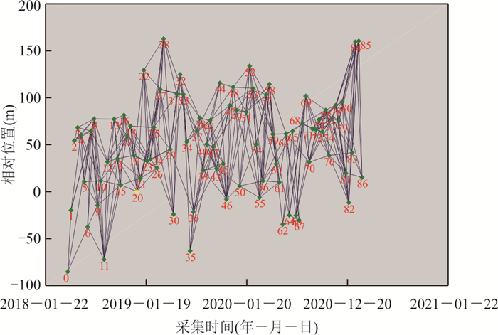
图 2 影像采集时间与空间相对位置
Fig. 2. The relative position of time and space of image acquisition

图 4 研究区时序InSAR形变分布及野外复核照片
Fig. 4. InSAR deformation distribution and field validation in the study area
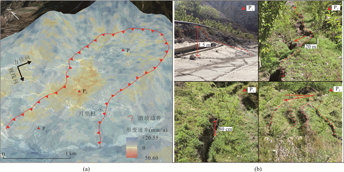
图 5 月里村滑坡年平均形变速率与野外复核照片
a.SBAS-InSAR形变测量结果;b.控制点野外复核
Fig. 5. The annual average deformation and field validation of potential landslide in the Yueli Village
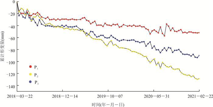
图 6 月里村滑坡视线向累计形变曲线
Fig. 6. Cumulative LOS displacements of potential landslide in the Yueli Village
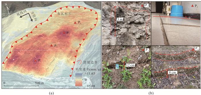
图 7 布瓦村滑坡年平均形变速率与野外复核照片
a.SBAS-InSAR形变测量结果;b.控制点野外复核
Fig. 7. The annual average deformation and field validation of potential landslide in the Buwa Village
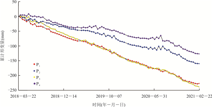
图 8 布瓦村滑坡视线向累计形变曲线
Fig. 8. Cumulative LOS displacements of potential landslide in the Buwa Village

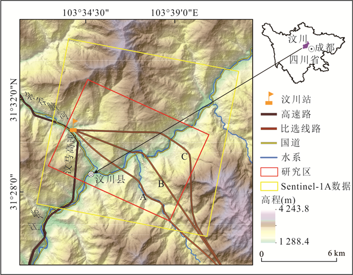
图 9 滑坡易发区选线设计方案
Fig. 9. Design scheme of route selection for high susceptibility of landslide area
表 1 研究区SAR数据参数
Table 1. SAR data parameters in the study area
轨道方向 成像模式 波段 波长(cm) 地面分
辨率(m)重访周期(d) 视角(°) 极化方式 降轨 IW C 5.6 5×20 12 39 VV  下载: 导出CSV
表 2 基于InSAR技术识别的滑坡隐患基本特征信息
Table 2. Basic characteristics of potential landslides detected by InSAR
滑坡隐患编号 滑坡名称 经度 纬度 规模类型 滑坡方量(104 m3) 最大累计形变量(mm) H1 通山村滑坡 103°38′55.69″ 31°27′18.55″ 大型土质滑坡 483.44 -125.13 H2 萝卜寨滑坡 103°40′02.64″ 31°30′16.14″ 特大型岩质滑坡 1 304.70 -98.454 H3 索桥村滑坡 103°39′06.88″ 31°29′28.41″ 特大型岩质滑坡 982.68 -115.38 H4 月里村滑坡 103°38′04.41″ 31°28′16.24″ 特大型岩质滑坡 3 641.67 -146.95 H5 月里村北侧滑坡 103°37′56.05″ 31°28′40.74″ 大型岩质滑坡 840.80 -89.64 H6 白水村滑坡 103°37′17.37″ 31°28′13.55″ 大型岩质滑坡 329.12 90.62 H7 秉里村滑坡 103°36′41.48″ 31°28′37.77″ 大型土质滑坡 613.43 -258.54 H8 磨村滑坡 103°35′46.77″ 31°31′00.05″ 特大型岩质滑坡 1 741.58 -178.52 H9 布瓦村滑坡 103°35′29.15″ 31°29′37.59″ 特大型岩质滑坡 4 412.04 -285.24 H10 小克枯滑坡 103°34′30.47″ 31°31′06.42″ 特大型岩质滑坡 1 317.93 -231.87
下载: 导出CSV
-
Berardino, P., Fornaro, G., Lanari, R., et al., 2002. A New Algorithm for Surface Deformation Monitoring Based on Small Baseline Differential SAR Interferograms. IEEE Transactions on Geoscience and Remote Sensing, 40(11): 2375-2383. https://doi.org/10.1109/tgrs.2002.803792 Bürgmann, R., Rosen, P., Fielding, E., 2000. Synthetic Aperture Radar Interferometry to Measure Earth's Surface Topography and Its Deformation. Annual Review of Earth and Planetary Sciences, 28(1): 169-209. https://doi.org/10.1146/annurev.earth.28.1.169 Chen, F. L., Lin, H., Li, Z., et al., 2012. Interaction between Permafrost and Infrastructure along the Qinghai-Tibet Railway Detected via Jointly Analysis of C- and L-Band Small Baseline SAR Interferometry. Remote Sensing of Environment, 123: 532-540. https://doi.org/10.1016/j.rse.2012.04.020 Chen, Q., Liu, G. X., Hu, Z. Q., et al., 2012. Mapping Ground 3-D Displacement with GPS and PS-InSAR Networking in the Pingtung Area, Southwestern Taiwan, China. Chinese Journal of Geophysics, 55(10): 3248-3258(in Chinese with English abstract). Cheng, S., Yi, J. Q., 2007. Geological Hazards and Their Preventions in Wenchuan County, Sichuan Province. Journal of Geological Hazards and Environment Preservation, 18(4): 1-6(in Chinese with English abstract). Dong, X. J., Wang, D., Feng, T., 2019. Research on the Application of Unmanned Aerial Vehicle Digital Photogrammetry in Landslide Disaster Investigation. Journal of Geological Hazards and Environment Preservation, 30(3): 77-84(in Chinese with English abstract). Feng, W. K., Dun, J. W., Yi, X. Y., et al., 2020. Deformation Analysis of Woda Village Old Landslide in Jinsha River Basin Using SBAS-INSAR Technology. Journal of Engineering Geology, 28(2): 384-393(in Chinese with English abstract). Ferretti, A., Prati, C., Rocca, F. L., 1999. Permanent Scatterers in SAR Interferometry. Remote Sensing. Proc SPIE 3869, SAR Image Analysis, Modeling, and Techniques II. Florence, Italy, 139-145. https://doi.org/10.1117/12.373150 Galarreta, J. F., Kerle, N., Gerke, M., 2015. UAV-Based Urban Structural Damage Assessment Using Object-Based Image Analysis and Semantic Reasoning. Natural Hazards and Earth System Sciences, 15(6): 1087-1101. https://doi.org/10.5194/nhess-15-1087-2015 Guo, J. M., Hu, J. Y., Li, B., et al., 2017. Land Subsidence in Tianjin for 2015 to 2016 Revealed by the Analysis of Sentinel-1A with SBAS-InSAR. Journal of Applied Remote Sensing, 11: 026024. https://doi.org/10.1117/1.jrs.11.026024 Huang, R. Q., 2007. Large-Scale Landslides and Their Sliding Mechanisms in China since the 20th Century. Chinese Journal of Rock Mechanics and Engineering, 26(3): 433-454(in Chinese with English abstract). Huo, D. P., Zhang, B., Peng, J. H., et al., 2015. Review and Prospective of Landslide Deformation Monitoring. Geotechnical Investigation & Surveying, 43(8): 62-67(in Chinese with English abstract). Li, D., Deng, K. Z., Gao, X. X., et al., 2018. Monitoring and Analysis of Surface Subsidence in Mining Area Based on SBAS-InSAR. Geomatics and Information Science of Wuhan University, 43(10): 1531-1537(in Chinese with English abstract). Lin, H., Ma, P. F., Wang, W. X., 2017. Urban Infrastructure Health Monitoring with Spaceborne Multi-Temporal Synthetic Aperture Radar Interferometry. Acta Geodaetica et Cartographica Sinica, 46(10): 1421-1433(in Chinese with English abstract). Liu, G. W., 2016. Application of Multi-Scale 3D Remote Sensing Technology for Geological Investigation in Railway. Journal of Railway Engineering Society, 33(8): 40-43, 99(in Chinese with English abstract). Liu, X. Y., Yang, Z. H., Guo, C. B., et al., 2017. Study of Slow-Moving Landslide Characteristics Based on the SBAS-InSAR in the Xianshuihe Fault Zone. Geoscience, 31(5): 965-977(in Chinese with English abstract). Lu, H. Y., Li, W. L., Xu, Q., et al., 2019. Early Detection of Landslides in the Upstream and Downstream Areas of the Baige Landslide, the Jinsha River Based on Optical Remote Sensing and InSAR Technologies. Geomatics and Information Science of Wuhan University, 44(9): 1342-1354(in Chinese with English abstract). Lü, X. K., Chen, J. J., 2015. Three-Dimensional Geological Environment Modeling Method for Digital Railway Alignment. Journal of the China Railway Society, 37(8): 91-97(in Chinese with English abstract). Ma, P. F., Wang, W. X., Zhang, B. W., et al., 2019. Remotely Sensing Large- and Small-Scale Ground Subsidence: A Case Study of the Guangdong-Hong Kong-Macao Greater Bay Area of China. Remote Sensing of Environment, 232: 111282. https://doi.org/10.1016/j.rse.2019.111282 Meng, H., Zhang, R. L., Shi, J. S., et al., 2021. Geological Environment Safety Evaluation. Earth Science, 46(10): 3764-3776(in Chinese with English abstract). Shi, X. G., Xu, J. H., Jiang, H. J., et al., 2019. Slope Stability State Monitoring and Updating of the Outang Landslide, Three Gorges Area with Time Series InSAR Analysis. Earth Science, 44(12): 4284-4292(in Chinese with English abstract). Shi, Y., Li, W. X., Tang, Y. M., et al., 2019. Time Series InSAR Measurement for Earth Environmental Monitoring and Resource Management: A Case Study of Jiaocheng-Qingxu Area. Geomatics and Information Science of Wuhan University, 44(11): 1613-1621(in Chinese with English abstract). Tao, Y. L., Zhang, M., 2019. Research on Mine Surface GPS Monitoring Based on Beidou System. Mineral Exploration, 10(12): 2990-2994(in Chinese with English abstract). Wang, G. J., Xie, M. W., Qiu, C., et al., 2010. Application of D-INSAR Technique to Landslide Monitoring. Rock and Soil Mechanics, 31(4): 1337-1344(in Chinese with English abstract). Wang, R. Y., 2015. Research on High Resolution Land Subsidence Monitoring Technology Based on SBAS InSAR(Dissertation). China University of Geosciences, Beijing(in Chinese with English abstract). Wang, X. M., Yin, J., Luo, M. H., et al. 2021. Active High-Locality Landslides in Mao County: Early Identification and Deformational Rules. Journal of Earth Science. https://doi.org/10.1007/s12583-021-1505-0 Xu, Q., Dong, X. J., Li, W. L., 2019. Integrated Space-Air-Ground Early Detection, Monitoring and Warning System for Potential Catastrophic Geohazards. Geomatics and Information Science of Wuhan University, 44(7): 957-966(in Chinese with English abstract). Yin, K. L., Han, Z. S., Li, Z. Z., 2000. Progress of Landslide Researches in the World. Hydrogeology and Engineering Geology, 27(5): 1-4(in Chinese with English abstract). Yin, Y. P., Pan, G. T., Liu, Y. P., 2009. Introduction to Wenchuan Earthquake Geology and Landslide Disaster. Geological Publishing House, Beijing(in Chinese). Yu, M. Y., Yu, C. Q., Qu, C., et al., 2021. Deep Structural Characteristics of Pengguan Complex in Longmenshan Fault Zone Derived from Seismic Reflective Profile. Earth Science, 46(5): 1737-1748(in Chinese with English abstract). Zhu, J. J., Li, Z. W., Hu, J., 2017. Research Progress and Methods of InSAR for Deformation Monitoring. Acta Geodaetica et Cartographica Sinica. 46(10): 1717-1733(in Chinese with English abstract). 陈强, 刘国祥, 胡植庆, 等, 2012. GPS与PS-InSAR联网监测的台湾屏东地区三维地表形变场. 地球物理学报, 55(10): 3248-3258. doi: 10.6038/j.issn.0001-5733.2012.10.007 程思, 易加强, 2007. 四川省汶川县地质灾害的成因及防治对策. 地质灾害与环境保护, 18(4): 1-6. doi: 10.3969/j.issn.1006-4362.2007.04.001 董秀军, 王栋, 冯涛, 2019. 无人机数字摄影测量技术在滑坡灾害调查中的应用研究. 地质灾害与环境保护, 30(3): 77-84. doi: 10.3969/j.issn.1006-4362.2019.03.013 冯文凯, 顿佳伟, 易小宇, 等, 2020. 基于SBAS-InSAR技术的金沙江流域沃达村巨型老滑坡形变分析. 工程地质学报, 28(2): 384-393. https://www.cnki.com.cn/Article/CJFDTOTAL-GCDZ202002019.htm 黄润秋, 2007.20世纪以来中国的大型滑坡及其发生机制. 岩石力学与工程学报, 26(3): 433-454. doi: 10.3321/j.issn:1000-6915.2007.03.001 霍东平, 张彬, 彭军还, 等, 2015. 滑坡变形监测技术研究现状与展望. 工程勘察, 43(8): 62-67. https://www.cnki.com.cn/Article/CJFDTOTAL-GCKC201508013.htm 李达, 邓喀中, 高晓雄, 等, 2018. 基于SBAS-InSAR的矿区地表沉降监测与分析. 武汉大学学报(信息科学版), 43(10): 1531-1537. https://www.cnki.com.cn/Article/CJFDTOTAL-WHCH201810014.htm 林珲, 马培峰, 王伟玺, 2017. 监测城市基础设施健康的星载MT-InSAR方法介绍. 测绘学报, 46(10): 1421-1433. doi: 10.11947/j.AGCS.2017.20170339 刘桂卫, 2016. 多尺度三维遥感技术在某铁路地质勘察中应用. 铁道工程学报, 33(8): 40-43, 99. doi: 10.3969/j.issn.1006-2106.2016.08.009 刘筱怡, 杨志华, 郭长宝, 等, 2017. 基于SBAS-InSAR的鲜水河断裂带蠕滑型滑坡特征研究. 现代地质, 31(5): 965-977. doi: 10.3969/j.issn.1000-8527.2017.05.008 陆会燕, 李为乐, 许强, 等, 2019. 光学遥感与InSAR结合的金沙江白格滑坡上下游滑坡隐患早期识别. 武汉大学学报(信息科学版), 44(9): 1342-1354. https://www.cnki.com.cn/Article/CJFDTOTAL-WHCH201909011.htm 吕希奎, 陈进杰, 2015. 铁路数字化选线三维地质环境建模方法. 铁道学报, 37(8): 91-97. doi: 10.3969/j.issn.1001-8360.2015.08.014 孟晖, 张若琳, 石菊松, 等, 2021. 地质环境安全评价. 地球科学, 46(10): 3764-3776. doi: 10.3799/dqkx.2019.031 史绪国, 徐金虎, 蒋厚军, 等, 2019. 时序InSAR技术三峡库区藕塘滑坡稳定性监测与状态更新. 地球科学, 44(12): 4284-4292. doi: 10.3799/dqkx.2019.180 师芸, 李伟轩, 唐亚明, 等, 2019. 时序InSAR技术在地球环境监测及其资源管理中的应用: 以交城-清徐地区为例. 武汉大学学报(信息科学版), 44(11): 1613-1621. https://www.cnki.com.cn/Article/CJFDTOTAL-WHCH201911005.htm 王桂杰, 谢谟文, 邱骋, 等, 2010. D-INSAR技术在大范围滑坡监测中的应用. 岩土力学, 31(4): 1337-1344. doi: 10.3969/j.issn.1000-7598.2010.04.057 王如意, 2015. 基于SBAS-InSAR的高分辨率地面沉降监测技术研究(博士学位论文). 北京: 中国地质大学. 许强, 董秀军, 李为乐. 2019. 基于天-空-地一体化的重大地质灾害隐患早期识别与监测预警. 武汉大学学报(信息科学版), 44(7): 957-966. https://www.cnki.com.cn/Article/CJFDTOTAL-WHCH201907002.htm 殷坤龙, 韩再生, 李志中, 2000. 国际滑坡研究的新进展. 水文地质工程地质, 27(5): 1-4. doi: 10.3969/j.issn.1000-3665.2000.05.001 殷跃平, 潘桂棠, 刘宇平, 2009. 汶川地震地质与滑坡灾害概论. 北京: 地质出版社. 于明羽, 于常青, 瞿辰, 等, 2021. 从反射地震剖面认识龙门山断裂带彭灌杂岩深部结构. 地球科学, 46(5): 1737-1748. doi: 10.3799/dqkx.2020.020 张明, 2019. 基于北斗系统的矿山地表GPS监测研究. 矿产勘查, 10(12): 2990-2994. doi: 10.3969/j.issn.1674-7801.2019.12.015 朱建军, 李志伟, 胡俊, 2017. InSAR变形监测方法与研究进展. 测绘学报, 46(10): 1717-1733. doi: 10.11947/j.AGCS.2017.20170350 -

 点击查看大图
计量
- 文章访问数: 1400
- HTML全文浏览量: 1024
- PDF下载量: 104
- 被引次数: 0
