


Susceptibility Assessment of Land Subsidence of Transmission Line Towers in the Salt Lake Area Based on Remote Sensing Interpretation
-
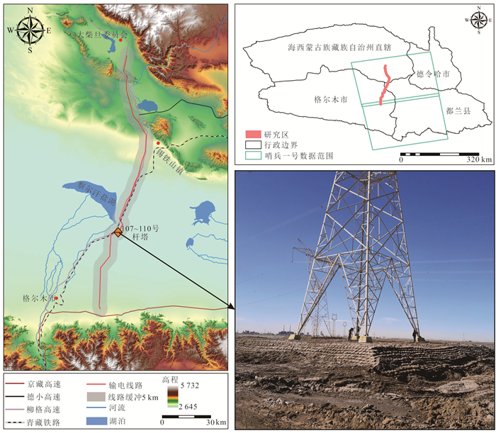
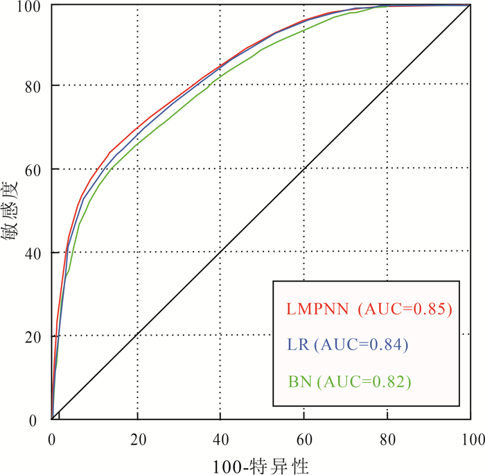
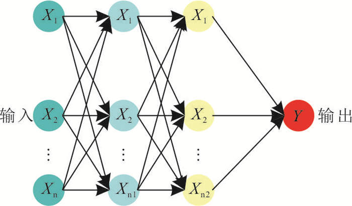
摘要: 跨越察尔汗盐湖地区的750 kV柴鱼输电线路是国家西部能源运输通道上重要的一环,受盐湖地区特殊的地质环境与人类活动影响,使得部分杆塔塔基发生不均匀沉降,严重威胁到输电线路的安全运行. 针对盐湖地区目前存在的杆塔地基变形破坏问题,利用小基线集合成孔径雷达干涉测量(SBAS-InSAR)技术对杆塔基础变形失稳前2018年的Sentinel-1A数据开展遥感解译,获取了盐湖地区地面沉降分布情况. 基于频率比法,筛选出与地面沉降相关性较强的8种评价因子构建盐湖地区地面沉降易发性评价指标体系,采用多层感知器神经网络(MLPNN)、逻辑回归(LR)、贝叶斯网络(BN),对比分析了盐湖地区地面沉降的易发性评价效果和精度. 评价结果表明,MLPNN、LR、BN的评价精度均较高,分别为0.85、0.84、0.82. 这表明,通过遥感解译获得地面沉降样本数据与机器学习相结合的方法是盐湖地区输电线路杆塔地面沉降易发性评价的有效手段;同时,评价结果可为输电线路杆塔监测、运行管理及新塔选址提供参考.Abstract: The 750 kV Chaiyu transmission line across the Qarhan Salt Lake area is an important part of the energy transportation channel in the western part of the country. Affected by the special geological environment and human activities in the salt lake area, some tower foundations have uneven settlement, which seriously threatens the safe operation of the transmission line. Aiming at the problem of deformation and failure of tower foundation in salt lake area, small baseline integrated aperture radar interferometry (SBAS-InSAR) technology was used to carry out remote sensing interpretation of Sentinel 1A data in 2018 before the deformation and instability of tower foundation, and the distribution of ground subsidence in salt lake area was obtained. Based on the frequency ratio method, eight evaluation factors with strong correlation with land subsidence were selected to construct the evaluation index system of land subsidence susceptibility in the salt lake region. The multi-layer perceptron neural network(MLPNN), logical regression(LR) and Bayesian network(BN) were used to compare and analyze the evaluation effect and accuracy of land subsidence susceptibility in the salt lake region. The evaluation results show that the evaluation accuracy of MLPNN, LR and BN is high, which are 0.85, 0.84 and 0.82, respectively. This shows that the method of combining the sample data of land subsidence obtained by remote sensing interpretation with machine learning is an effective means for evaluating the susceptibility of ground subsidence of transmission line towers in the salt lake region. At the same time, the evaluation results can provide reference for transmission line tower monitoring, operation management and new tower location.
-

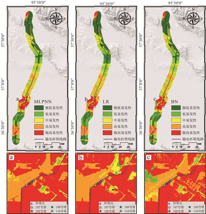
图 4 输电线路沿线地面变形遥感解译图
Fig. 4. Remote sensing interpretation map of ground deformation along transmission lines
表 1 地面沉降易发性评价指标体系及说明
Table 1. Land subsidence susceptibility evaluation index system and description
一级评价因子 二级评价因子 指标说明 地形地貌 坡度 随着坡度的增加,地下水补给和排泄、物质搬运与堆积、堆积体的厚度和松散度等都会发生改变. 平面曲率 平面曲率描述的是地形在水平方向的特征,在数值上等于某栅格处坡向在坡度上的变化. 剖面曲率 剖面曲率可以描述地形的复杂度,它是坡度的坡度. 基础地质 地层岩性 地层岩性是各类地质灾害发育的物质基础,对地面沉降发育具有基础性的控制作用. 水文环境 距河流距离 河流对地面具有冲刷侵蚀作用,会进一步改变地表形态. 地形湿度指数 地形湿度可用来定量模拟流域内地形和土壤水分的干湿状况 人类工程活动 距道路距离 车辆动荷载作用会影响地表的应力分布稳定性会发生较大改变. 土地利用类型 人类对于土地的破坏程度和干扰程度的差异可以通过土地利用类型来体现,在不同的土地利用类型区域内,地面沉降发生的概率和发育的密度都有所差异.  下载: 导出CSV
表 2 研究区地面沉降易发性评价因子分级
Table 2. Classification of land subsidence susceptibility evaluation factors in study area
评价因子 分类 类型 全区栅格数 栅格占比 地面沉降栅格数 地面沉降栅格占比 FR 坡度(°) 0~5 连续型 797 379 0.777 132 214 0.854 1.098 5~20 202 985 0.198 21 633 0.140 0.706 > 20 25 371 0.025 1 035 0.007 0.270 剖面曲率 -0.2 连续型 78 901 0.077 11 063 0.071 0.929 -0.2~0 513 544 0.501 81 362 0.525 1.049 0~0.2 355 055 0.346 52 793 0.341 0.985 > 0.2 78 235 0.076 9 664 0.062 0.818 平面曲率 < -1 连续型 91 196 0.089 9 984 0.064 0.725 -1~01 579 113 0.565 92 804 0.599 1.061 0.01~0.02 302 010 0.294 43 169 0.279 0.947 > 0.02 73 416 0.072 8 925 0.058 0.805 地层岩性 化学沉积物 离散型 250 609 0.244 65 979 0.426 1.744 沼泽沉积物 88 626 0.086 10 387 0.067 0.776 湖积物 34 406 0.034 17 748 0.115 3.416 洪积物 229 941 0.224 31 112 0.201 0.896 冲积物 125 001 0.122 552 0.004 0.029 风积物 48 116 0.047 7 964 0.051 1.096 较坚硬岩 197 692 0.193 21 122 0.136 0.708 坚硬岩 51 344 0.050 18 0 0.002 距河流的距离(m) 0~300 离散型 44 133 0.043 14 596 0.094 2.190 300~600 41 710 0.041 11 136 0.072 1.768 600~900 72 020 0.070 15 885 0.103 1.461 > 900 867 872 0.846 113 265 0.731 0.864 地形湿度指数 < 6 连续型 173 047 0.169 16 292 0.105 0.624 6~13 443 366 0.432 64 892 0.419 0.969 13~25 139 927 0.136 21 697 0.140 1.027 > 25 269 395 0.263 52 001 0.336 1.278 距道路的距离(m) 0~400 离散型 158 670 0.155 25 895 0.167 1.081 400~800 132 811 0.129 19 808 0.128 0.988 800~1 200 118 658 0.116 17 106 0.110 0.955 > 1 200 615 596 0.600 92 073 0.594 0.991 土地利用类型 建设用地 离散型 29 530 0.029 2 667 0.017 0.598 草地 114 370 0.112 32 656 0.211 1.891 水体 4 997 0.005 79 0.001 0.105 裸地 795 944 0.776 66 495 0.429 0.553 盐池 80 894 0.079 52 985 0.342 4.338
下载: 导出CSV
表 3 评价因子多重共线性诊断
Table 3. Multicollinearity diagnosis of evaluation factors
评价因子 TOL VIF 坡度 0.833 1.201 剖面曲率 0.808 1.049 平面曲率 0.787 1.108 地层岩性 0.873 1.145 距河流的距离 0.947 1.056 地形湿度指数 0.863 1.159 距道路的距离 0.992 1.008 土地利用类型 0.964 1.038
下载: 导出CSV
表 4 研究区地面沉降易发性评价频率比
Table 4. Frequency ratio of land subsidence susceptibility evaluation in study area
评价模型 易发性等级 分级栅格数 分级比例(%) 地面沉降栅格数 地面沉降比例(%) FR MLPNN 极低 307 720 0.300 3 218 0.021 0.099 低 205 147 0.200 14 312 0.092 0.722 中 205 147 0.200 24 241 0.157 1.455 高 205 147 0.200 45 493 0.294 2.699 极高 102 574 0.100 67 618 0.437 4.467 LR 极低 307 720 0.300 8 044 0.052 0.219 低 205 147 0.200 16 196 0.105 0.824 中 205 147 0.200 24 120 0.156 1.777 高 205 147 0.200 42 708 0.276 2.833 极高 102 574 0.100 63 814 0.412 4.285 BN 极低 307 720 0.300 3 324 0.021 0.122 低 205 147 0.200 14 563 0.094 0.747 中 205 147 0.200 27 349 0.177 1.338 高 205 147 0.200 42 673 0.276 2.728 极高 102 574 0.100 66 973 0.432 4.438
下载: 导出CSV
-
Atkinson, P. M., Massari, R., 2011. Autologistic Modelling of Susceptibility to Landsliding in the Central Apennines, Italy. Geomorphology, 130(1/2): 55-64. https://doi.org/10.1016/j.geomorph.2011.02.001 Bianchini, Solari, Soldato, et al., 2019. Ground Subsidence Susceptibility (GSS) Mapping in Grosseto Plain (Tuscany, Italy) Based on Satellite InSAR Data Using Frequency Ratio and Fuzzy Logic. Remote Sensing, 11(17): 2015. https://doi.org/10.3390/rs11172015 Buscema, M., 2002. A Brief Overview and Introduction to Artificial Neural Networks. Substance Use & Misuse, 37(8/9/10): 1093-1148. https://doi.org/10.1081/ja-120004171 Chen, G., Zhang, Y., Zeng, R. Q., et al., 2018. Detection of Land Subsidence Associated with Land Creation and Rapid Urbanization in the Chinese Loess Plateau Using Time Series InSAR: A Case Study of Lanzhou New District. Remote Sensing, 10(2): 270. https://doi.org/10.3390/rs10020270 Du, Q., Li, G., Zhou, Y., et al., 2021. Deformation Monitoring in an Alpine Mining Area in the Tianshan Mountains Based on SBAS-InSAR Technology. Advances in Materials Science and Engineering, 2021(12): 1-15. https://doi.org/10.1155/2021/9988017 Fadhillah, M. F., Achmad, A. R., Lee, C. W., 2020. Integration of InSAR Time-Series Data and GIS to Assess Land Subsidence along Subway Lines in the Seoul Metropolitan Area, South Korea. Remote Sensing, 12(21): 3505. https://doi.org/10.3390/rs12213505 Fergason, K. C., Rucker, M. L., Panda, B. B., 2015. Methods for Monitoring Land Subsidence and Earth Fissures in the Western USA. Proceedings of the International Association of Hydrological Sciences, 372: 361-366. https://doi.org/10.5194/piahs-372-361-2015 Gao, X. X., Li, S. M., Chen, P. D., et al., 2022. Research on Instability Mechanism of Transmission Tower under Time-Series In SAR Slope Slip Monitoring. Journal of Guizhou University(Natural Sciences), 39(1): 43-50 (in Chinese with English abstract). Guo, Z. Z., Yin, K. L., Fu, S., et al., 2019. Evaluation of Landslide Susceptibility Based on GIS and WOE-BP Model. Earth Science, 44(12): 4299-4312 (in Chinese with English abstract). Hakim, W., Achmad, A., Lee, C. W., 2020. Land Subsidence Susceptibility Mapping in Jakarta Using Functional and Meta-Ensemble Machine Learning Algorithm Based on Time-Series InSAR Data. Remote Sensing, 12(21): 3627. https://doi.org/10.3390/rs12213627 Han, L. N., Zhang, J. Q., Zhang, Y. C., et al., 2019. Applying a Series and Parallel Model and a Bayesian Networks Model to Produce Disaster Chain Susceptibility Maps in the Changbai Mountain Area, China. Water, 11(10): 2144. https://doi.org/10.3390/w11102144 He, S. W., Pan, P., Dai, L., et al., 2012. Application of Kernel-Based Fisher Discriminant Analysis to Map Landslide Susceptibility in the Qinggan River Delta, Three Gorges, China. Geomorphology, 171-172(6): 30-41. https://doi.org/10.1016/j.geomorph.2012.04.024 Holzer, T. L., Galloway, D. L., 2005. Impacts of Land Subsidence Caused by Withdrawal of Underground Fluids in the United States. Humans as Geologic Agents, 4016(8). https://doi.org/10.1130/2005.4016(8) Huang, F. M., Ye, Z., Yao, C., et al., 2020. Uncertainties of Landslide Susceptibility Prediction: Different AttributeInterval Divisions of Environmental Factors and Different Data-Based Models. Earth Science, 46(10): 3777-3795 (in Chinese with English abstract). Ilia, I., Tsangaratos, P., 2016. Applying Weight of Evidence Method and Sensitivity Analysis to Produce a Landslide Susceptibility Map. Landslides, 13(2): 379-397. https://doi.org/10.1007/s10346-015-0576-3 Li, W. B., Fan, X. M., Huang, F. M., et al., 2021. Uncertainties of Landslide Susceptibility Modeling under DifferentEnvironmental Factor Connections and Prediction Models. Earth Science, 46(10): 3777-3795 (in Chinese with English abstract). Luo, Y. D., 2010. Distribution Law of Saline Soil and Its Salt Expansion and Subsidence Mechanism in Qinghai. Hydrogeological Engineering Geology, 37 (4): 116-120 (in Chinese). Mohammady, M., Pourghasemi, H. R., Amiri, M., 2019. Land Subsidence Susceptibility Assessment Using Random Forest Machine Learning Algorithm. Environmental Earth Sciences, 78(16): https://doi.org/10.1007/s12665-019-8518-3 Moreira, A., Prats-Iraola, P., Younis, M., et al., 2013. A Tutorial on Synthetic Aperture Radar. IEEE Geoscience and Remote Sensing Magazine, 1(1): 6-43. https://doi.org/10.1109/mgrs.2013.2248301 Ning, Z. W., 2014. Study on the Highway Foundation Settlement Regularity of Soft Soil Salinization in Yanhu Area (Dissertation). Chang' an University, Xi'an, 19-35 (in Chinese with English abstract). Qi, Z. X., Wang, X. J., Liu, C. Q., et al., 2021. Analysis on Collapsible Deformation and Prevention Measures of Transmission Line Tower Ground in Qarhan Salt Lake Area. Electric Power Survey and Design, (5): 72-76 (in Chinese with English abstract). Shi, M., Gong, H. L., Gao, M. L., et al., 2020. Recent Ground Subsidence in the North China Plain, China, Revealed by Sentinel-1A Datasets. Remote Sensing, 12(21): 3579. https://doi.org/10.3390/rs12213579 Wang, Z, J., 1986. Engineering Geological Study of Ground Subsidence. Earth Science, (2): 199-206 (in Chinese). Wei, Z. Y., 2007. Harm of Qinghai Saline Soil to Power Transformation Engineering and Treatment Measure. Qinghai Electric Power, (S1): 40-44 (in Chinese with English abstract). Xiang, W., Zhang, R., Liu, G. X., et al., 2022. Extraction and Analysis of Saline Soil Deformation in the Qarhan Salt Lake Region (in Qinghai, China) by the Sentinel SBAS-InSAR Technique. Geodesy and Geodynamics, 13(2): 127-137. https://doi.org/10.1016/j.geog.2020.11.003 Xu, Q., Pu, C. H., Zhao, K. Y., et al., 2021. Time Series InSAR Monitoring and Analysis of Spatiotemporal Evolution Characteristics of Land Subsidence in Yan'an New District. Geomatics and Information Science of Wuhan University, 46(7): 957-969 (in Chinese with English abstract) Yan, T, Z., 1989. New Model for Predicting Land Subsidence. Earth Science, (2): 181-188 (in Chinese). Zhang, Z. J., Wang, C., Wang, M. M., et al., 2018. Surface Deformation Monitoring in Zhengzhou City from 2014 to 2016 Using Time-Series InSAR. Remote Sensing, 10(11): 1731. https://doi.org/10.3390/rs10111731 Zhang, Z. Y., Deng, M. G., Xu, S. G., 2022. Comparison of Landslide Susceptibility Assessment Models in Zhenkang County, Yunnan Province, China. Chinese Journal of Rock Mechanics and Engineering, 41(1): 157-171 (in Chinese with English abstract). Zhou, C., Yin, K. L., Cao, Y., et al., 2020. Landslide Susceptibility Assessment by Applying the Coupling Method of Radial Basis Neural Network and Adaboost: A Case Study from the Three Gorges Reservoir Area. Earth Science, 45(6): 1865-1876 (in Chinese with English abstract). Zhu, X, G., Ming, S., 2021. Application of Time Series In SAR Technology in Prevention and Control of Surface Deformation Disaster of High-Voltage Transmission line. Bulletin of Surveying and Mapping, (7): 92-97 (in Chinese with English abstract). 高霞霞, 李素敏, 陈朋弟, 等, 2021. 时序InSAR边坡滑移监测下输电杆塔失稳机理研究. 贵州大学学报(自然科学版), 39(1): 43-50. https://www.cnki.com.cn/Article/CJFDTOTAL-GZDI202201006.htm 郭子正, 殷坤龙, 付圣, 等, 2019. 基于GIS与WOE-BP模型的滑坡易发性评价. 地球科学, 44(12): 4299-4312. doi: 10.3799/dqkx.2018.555 黄发明, 舟叶, 池姚, 等, 2020. 滑坡易发性预测不确定性: 环境因子不同属性区间划分和不同数据驱动模型的影响. 地球科学, 12(45): 4535-4549. doi: 10.3799/dqkx.2020.247 李文彬, 范宣梅, 黄发明, 等, 2021. 不同环境因子联接和预测模型的滑坡易发性建模不确定性. 地球科学, 46(10): 3777-3795. doi: 10.3799/dqkx.2021.042 罗友弟, 2010. 青海地区盐渍土分布规律及其盐胀溶陷机制探讨. 水文地质工程地质, 37(4): 116-120. https://www.cnki.com.cn/Article/CJFDTOTAL-SWDG201004027.htm 宁展望, 2014. 盐湖区高速公路盐渍化软土地基沉降规律研究(硕士学位论文). 西安: 长安大学. 祁兆鑫, 王新军, 刘常青, 等, 2021. 察尔汗盐湖区输电线路杆塔地基溶陷变形分析及防治措施. 电力勘测设计, (5): 72-76 https://www.cnki.com.cn/Article/CJFDTOTAL-DLKC202105017.htm 王智济, 1986. 地面沉降的工程地质研究. 地球科学, (2): 199-206. https://www.cnki.com.cn/Article/CJFDTOTAL-DQKX198602013.htm 魏占元, 2007. 青海盐渍土对变电工程的危害与治理措施. 青海电力, (S1): 40-44. https://www.cnki.com.cn/Article/CJFDTOTAL-QHDL2007S1015.htm 许强, 蒲川豪, 赵宽耀, 等, 2021. 延安新区地面沉降时空演化特征时序InSAR监测与分析. 武汉大学学报(信息科学版), 46(7): 957-969. https://www.cnki.com.cn/Article/CJFDTOTAL-WHCH202107001.htm 晏同珍, 1989. 地面沉降规律预测新模式. 地球科学, (2): 181-188. https://www.cnki.com.cn/Article/CJFDTOTAL-DQKX198902009.htm 张钟远, 邓明国, 徐世光, 等, 2022. 镇康县滑坡易发性评价模型对比研究. 岩石力学与工程学报, 41(1): 157-171. https://www.cnki.com.cn/Article/CJFDTOTAL-YSLX202201013.htm 周超, 殷坤龙, 曹颖, 等, 2020. 基于集成学习与径向基神经网络耦合模型的三峡库区滑坡易发性评价. 地球科学, 45(6): 1865-1876. doi: 10.3799/dqkx.2020.071 祝昕刚, 明生, 2021. 时序InSAR技术应用于高压输电线路附近的地表形变灾害防控. 测绘通报, (7): 92-97. https://www.cnki.com.cn/Article/CJFDTOTAL-CHTB202107018.htm -


 点击查看大图
计量
- 文章访问数: 718
- HTML全文浏览量: 577
- PDF下载量: 69
- 被引次数: 0
