


Deformation Characteristics of Jiaju Ancient Landslide Based on InSAR Monitoring Method, Sichuan, China
-
摘要:
位于四川省丹巴县聂呷乡甲居村的甲居古滑坡主要由甲居滑坡(H01)、聂呷坪滑坡(H02)、小巴旺村滑坡(H03)、聂拉村滑坡(H04)和山顶滑坡(H05)等5个次级滑体组成.受区域构造、强降雨、河流侵蚀、地层岩性等因素影响,甲居古滑坡次级滑体持续发生蠕滑变形,对位于滑体上的村庄、道路和前缘大金河等具有较大危害,2020年遭受50年一遇的强降雨后,古滑坡变形速率有进一步增大的趋势.采用SBAS-InSAR技术,结合遥感解译和现场调查,获取了甲居古滑坡2018年6月至2021年8月的地表变形特征,通过二维形变速率转换获取了甲居古滑坡沿斜坡向(slope)和垂直向(vertical)的形变速率.研究认为,甲居古滑坡沿雷达视线方向(VLOS)形变速率最大达-179 mm/a,沿斜坡方向的形变速率(Vs)最大为-211 mm/a,沿垂直方向的变形速率(Vv)最大为-67 mm/a.甲居滑坡的北侧区域、聂拉村滑坡的南侧区域和山顶滑坡后缘变形较大,总体上位于强变形-极强变形区.甲居古滑坡的变形机制具有一定差异,其中甲居滑坡以牵引式变形为主,聂拉村滑坡以推挤式变形为主.由于古滑坡地质构造复杂、新构造活动强烈,在强降雨和河流侵蚀作用下极易导致滑坡蠕滑速率加快并进一步失稳,形成堵江溃坝等灾害.建议加强次级滑体的地表变形监测,为流域性地质安全风险防灾减灾提供技术支撑和科学依据.
Abstract:The Jiaju ancient landslide,located in Jiaju Village,Niexia Township,Danba County,Sichuan Province,is mainly composed of 5 secondary sliding bodies,such as Jiaju landslide (H01),Niexiaping landslide (H02),Xiaobawang Village landslide (H03),Niela Village landslide (H04),and the mountain top landslide (H05). Affected by factors such as regional structure,heavy rainfall,river erosion,stratigraphic lithology,etc.,the secondary sliding bodies of Jiaju ancient landslide continue to undergo creep deformation,which will cause certain harm to villages,roads and the front edge of Dajin River. The deformation rate tends to increase further after the occurrence of heavy rainfall that occurs once every 50 years in 2020. In this paper it uses SBAS-InSAR technology,combined with remote sensing interpretation and field investigation,obtained the surface deformation characteristics of the Jiaju ancient landslide from June 2018 to August 2021, and obtained the edge of the Jiaju ancient landslide through two-dimensional deformation rate conversion,the slope and vertical deformation rates. The research shows that the maximum deformation rate of the Jiaju ancient landslide along the radar line of sight (VLOS) is -179 mm/a,the maximum deformation rate along the slope direction (Vs) is -211 mm/a,and the maximum deformation rate along the vertical direction (Vv) is -67 mm/a. The northern area of the Jiaju landslide,the southern area of the Niela Village landslide,and the trailing edge of the mountain top landslide are largely deformed,and are generally located in the strong deformation-extremely strong deformation area. The deformation mechanisms of the Jiaju ancient landslide are different to some extent. The Jiaju landslide is dominated by traction deformation,while the Niela Village landslide is dominated by push deformation. Due to the complex geological structure of the ancient landslide and the strong neotectonic activity,under the action of heavy rainfall,it is easy to cause the landslide creep rate to accelerate and further destabilize,resulting in dammed lake and dam broken hazards. It is suggested to strengthen the surface deformation monitoring of secondary sliding bodies to provide technical support and scientific basis for geohazard prevention and mitigation of watershed geological safety risks.
-
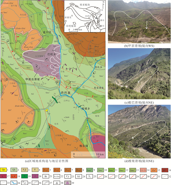
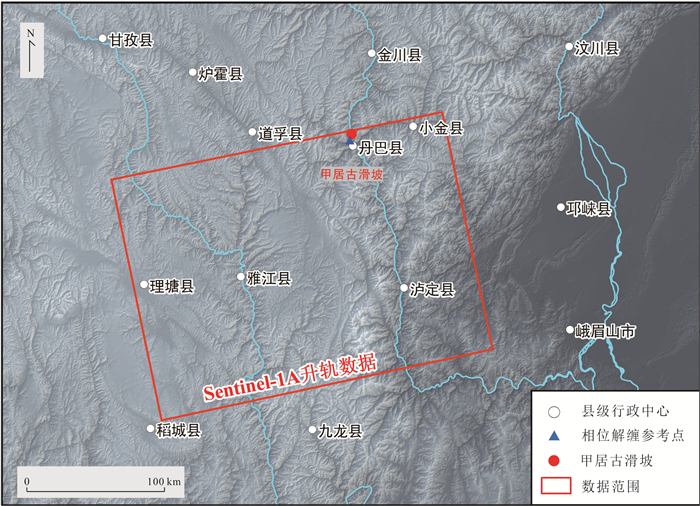
图 1 四川丹巴县甲居古滑坡区域构造位置图
1.更新统砂砾粘土;2.全新统砂砾粘土;3.二叠系上统玄武岩夹黑色板岩及灰岩;4.二叠系下统含砾砂岩、板岩、大理岩;5.泥盆系危关群第四岩组石英岩、(碳质)片岩、大理岩;6.泥盆系危关群第三岩组变砾岩、片岩、大理岩;7.泥盆系危关群第二岩组片岩、大理岩;8.泥盆系危关群第一岩组石英岩;9.志留系茂县群第五岩组石英岩、片岩;10.志留系茂县群第四岩组片岩夹条带状大理岩;11.志留系茂县群第三岩组石英岩夹片岩;12.志留系茂县群第二岩组片岩夹大理岩;13.志留系茂县群第一岩组片岩;14.震旦系上统灯影组陡山沱组白云质大理岩、片岩;15.震旦系下统变粒岩、含砾片岩、混合岩;16.燕山期早期辉石正长岩;17.燕山期早期石英二长岩;18.燕山期早期似斑状石英二长岩;19.海西期未分基性侵入岩;20.伟晶岩脉;21.黑云母带;22.十字石.铁铝榴石带;23.兰晶石带;24.矽线石带;25.未分超基性岩;26.实测断层;27.推测性质不明断层;28.实测正断层;29.推测正断层;30.实测逆断层;31.推测逆断层;32.实测地质界线;33.推测地质界限;34.水系;35.地层倾向及倾角、倒转底层产状;36.混杂岩界线;37.实测地质界限;38.高程点;39.甲居古滑坡范围
Fig. 1. The regional tectonic location map of Jiaju ancient landslide in Danba County, Sichuan Province
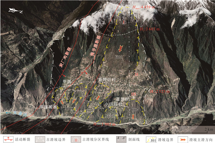
图 2 甲居古滑坡遥感解译图
Fig. 2. The remote sensing interpretation map of Jiaju ancient landslide

图 3 甲居古滑坡A-A′工程地质剖面图
1.二云英片岩夹大理岩;2.石英岩夹二云英片岩;3.二云英片岩夹变粒岩;4.云英质大理岩、片岩;5.浅粒岩夹片岩;6.断裂带;7.滑带;AA′见图 2
Fig. 3. The A-A′ engineering geological section profile of Jiaju ancient landslide
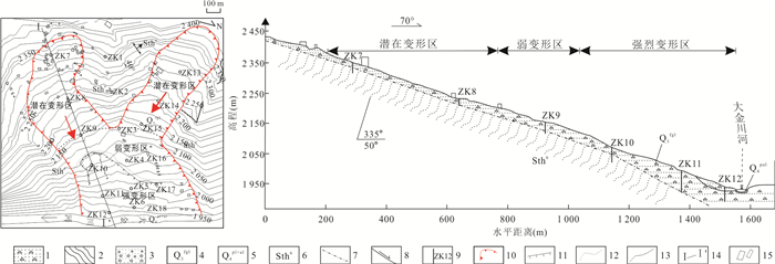
图 4 甲居滑坡工程地质剖面图(据李明辉等,2008)
图据李明辉等(2008);1.碎块石土;2.二云英片岩;3.砂、卵石;4.第四系上更新统冰水堆积层;5.第四系冲洪积物;6.志留系通化岩组第六段;7.推测地层界线;8.推测滑面;9.钻孔;10.滑坡边界;11.变形陡坎;12.变形区界线;13.地层界线;14.剖面线;15.建筑物
Fig. 4. The engineering geological section of Jiaju landslide (after Li et al., 2008)

图 8 雷达视线方向和坡度方向几何示意图(Cascini et al., 2010)
Fig. 8. Geometric sketch of radar line-of-sight direction and slope direction(Cascini et al., 2010)

图 9 基于SBAS-InSAR技术的甲居古滑坡形变速率分布图(LOS)
Fig. 9. Deformation rate distribution map of Jiaju ancient landslide based on SBAS-InSAR technology (LOS)
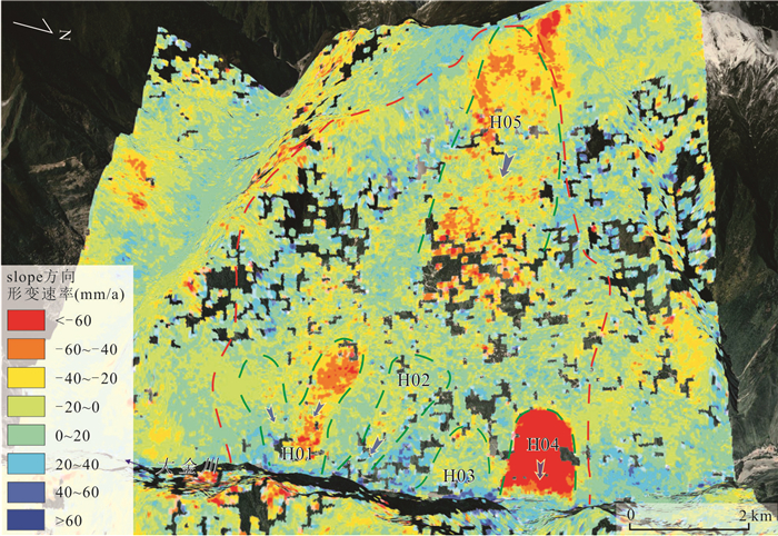
图 10 基于SBAS-InSAR技术的甲居古滑坡形变速率分布图(slope)
Fig. 10. Deformation rate distribution map of Jiaju ancient landslide based on SBAS-InSAR technology (slope)
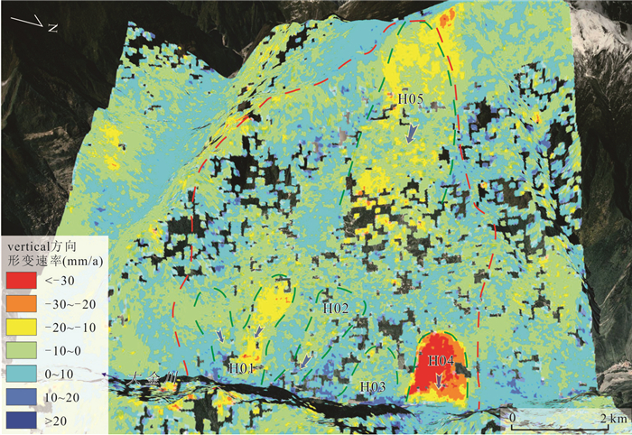
图 11 基于SBAS-InSAR技术的甲居古滑坡形变速率分布图(vertical)
Fig. 11. Deformation rate distribution map of Jiaju ancient landslide based on SBAS-InSAR technology (vertical)
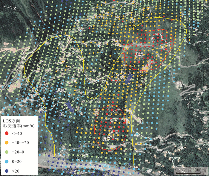
图 12 甲居滑坡遥感影像及InSAR形变图
Fig. 12. The remote sensing image and InSAR deformation map of Jiaju landslide
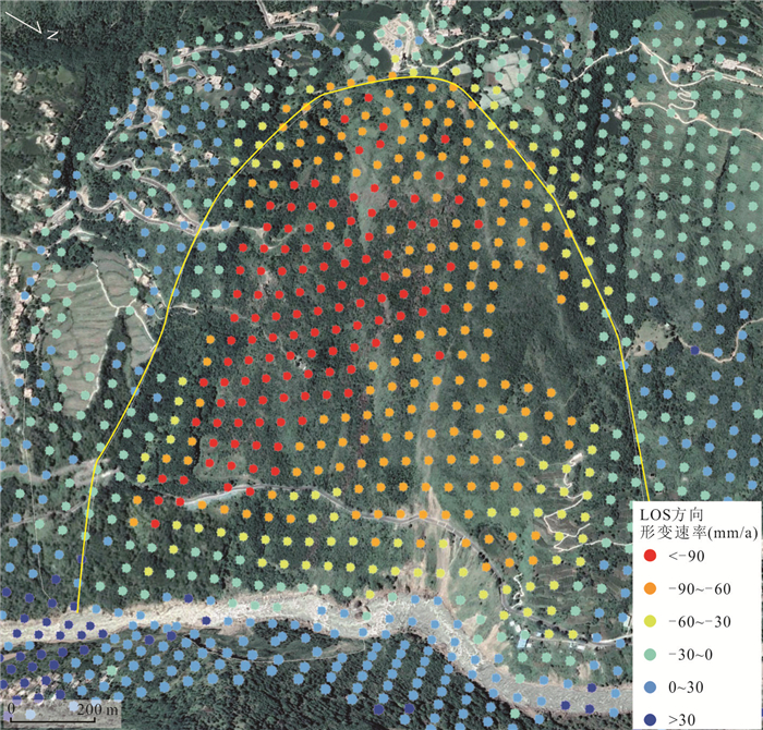
图 13 聂拉村滑坡遥感影像及InSAR形变图
Fig. 13. The remote sensing image and InSAR deformation map of Niela Village landslide
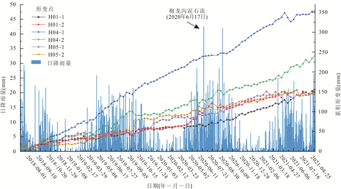
图 14 甲居古滑坡日降雨量与滑坡累计形变量之间的关系曲线
Fig. 14. The relationship between daily rainfall and cumulative deformation of the Jiaju ancient landslide
表 1 SAR影像数据基本参数
Table 1. The basic parameters of SAR image data
主要参数 参数值 轨道方向 升轨 轨道号Path 26 幅号Frame 93 所处波段 C 雷达波长(cm) 5.6 入射角(°) 43.90 影像间隔时间(d) 12 影像获取时间段 2018年6月24日至2021年8月31日 影像数量 96  下载: 导出CSV
表 2 时序InSAR分析滑坡探测识别结果
Table 2. Time series InSAR analysis of landslide detection and recognition results
滑坡名称 坡向(°) 坡度(°) 面积(km2) 最大LOS
形变速率
(mm·a-1)slope方向
形变速率
(mm·a-1)vertical方向
形变速率
(mm·a-1)甲居滑坡(H01-N) 112 20~35 0.6 -92 -108 -35 甲居滑坡(H01-S) 67 20~35 0.8 -42 -50 -16 聂呷坪滑坡(H02) 120 20~35 2.1 -44 -52 -17 小巴旺村滑坡(H03) 103 15~25 1.1 -32 -66 -22 聂拉村滑坡(H04) 87 15~30 1.3 -170 -211 -180 山顶滑坡(H05) 98 20~40 6.3 -87 -103 -33
下载: 导出CSV
-
Bai, Y. J., 2020. Research on Mesostructure and Evolution of Rock-Soil Aggregate Landslides in Deeply Incised Valleys: A Case Study of Rock-Soil Aggregate Landslides in the Danba Reach of the Dadu River (Dissertation). Chengdu University of Technology, Chengdu(in Chinese with English abstract). Bai, Y. J., Zheng, W. M., Deng, G. S., et al., 2011. Three-Dimensional System Monitoring and Numerical Simulation on the Dynamic Deformation Process of Jiaju Landslide in Danba, Sichuan. Chinese Journal of Rock Mechanics and Engineering, 30(5): 974-981(in Chinese with English abstract). Berardino, P., Fornaro, G., Lanari, R., et al., 2002. A New Algorithm for Surface Deformation Monitoring Based on Small Baseline Differential SAR Interferograms. IEEE Transactions on Geoscience and Remote Sensing, 40(11): 2375-2383. https://doi.org/10.1109/tgrs.2002.803792 Cascini, L., Fornaro, G., Peduto, D., 2010. Advanced Low-and Full-Resolution D-InSAR Map Generation for Slow-Moving Landslide Analysis at Different Scales. Engineering Geology, 112(1): 29-42. Chen, F., Deng, J. H., Gao, M. Z., et al., 2012. Geological Cause and Stability Evaluation of Moluocun Landslide, Danba County. Rock and Soil Mechanics, 33(6): 1781-1786(in Chinese with English abstract). doi: 10.3969/j.issn.1000-7598.2012.06.028 Colesanti, C., Wasowski, J., 2006. Investigating Landslides with Space-Borne Synthetic Aperture Radar (SAR) Interferometry. Engineering Geology, 88(3): 173-199. Dai, K. R., Zhuo, G. C., Xu, Q., et al., 2019. Tracing the Pre-Failure Two-Dimensional Surface Displacements of Nanyu Landslide, Gansu Province with Radar Interferometry. Geomatics and Information Science of Wuhan University, 44(12): 1778-1786, 1796(in Chinese with English abstract). Dong, J. F., Liao M., Xu, Q., et al., 2018. Detection and Displacement Characterization of Landslides Using Multi-Temporal Satellite SAR Interferometry: A Case Study of Danba County in the Dadu River Basin. Engineering Geology, 240(5): 95-109. https://doi.org/10.1016/j.enggeo.2018.04.015 Feng, W. K., Dun, J. W., Yi, X. Y., et al., 2020. Deformation Analysis of Woda Village Old Landslide in Jinsha River Basin Using SBAS-InSAR Technology. Journal of Engineering Geology, 28(2): 384-393(in Chinese with English abstract). Ferretti, A., Prati, C., Rocca, F., 2000. Nonlinear Subsidence Rate Estimation Using Permanent Scatterers in Differential SAR Interferometry. IEEE Transactions on Geoscience and Remote Sensing, 38(5): 2202-2212. https://doi.org/10.1109/36.868878 Fruneau, B., Achache, J., Delacourt, C., 1996. Observation and Modelling of the Saint-Étienne-de-Tinée Landslide Using SAR Interferometry. Tectonophysics, 265(3-4): 181-190. https://doi.org/10.1016/s0040-1951(96)00047-9 Guo, C. B., Montgomery, D. R., Zhang, Y. S., et al., 2020. Evidence for Repeated Failure of the Giant Yigong Landslide on the Edge of the Tibetan Plateau. Scientific Reports, 10: 14371. https://doi.org/10.1038/s41598-020-71335-w Guo, C. B., Zhang, Y. S., Jiang, L. W., et al., 2017. Discussion on the Environmental and Engineering Geological Problems along the Sichuan-Tibet Railway and Its Adjacent Area. Geoscience, 31(5): 877-889(in Chinese with English abstract). doi: 10.3969/j.issn.1000-8527.2017.05.001 Guo, C. B., Zhang, Y. S., Li, X., et al., 2019. Reactivation of Giant Jiangdingya Ancient Landslide in Zhouqu County, Gansu Province, China. Landslides, 17(1): 179-190. https://doi.org/10.1007/s10346-019-01266-9 Han, C. Y., 2016. Study on the Deformation Failure Model and Stability of the Abutment of Danba Hydroelectric Station in Dadu River (Dissertation). Chengdu University of Technology, Chengdu(in Chinese with English abstract). Hu, K. H., Zhang, X. P., Luo, H., et al., 2020. Investigation of the "6•17" Debris Flow Chain at the Meilong Catchment of Danba County, China. Mountain Research, 38(6): 945-951(in Chinese with English abstract). Lanari, R., Mora, O., Manunta, M., et al., 2004. A Small-Baseline Approach for Investigating Deformations on Full-Resolution Differential SAR Interferograms. IEEE Transactions on Geoscience and Remote Sensing, 42(7): 1377-1386. https://doi.org/10.1109/tgrs.2004.828196 Li, M. H., Zheng, W. M., Shi, S. W., et al., 2008. The Revival Mechanism and Stability Analysis to Jiaju Landslide of Danba County in Sichuan Province. Journal of Mountain Science, 26(5): 577-582(in Chinese with English abstract). doi: 10.3969/j.issn.1008-2786.2008.05.011 Liu, P., 2006. Research on the Stablilty and Controlling Engineering Effect of the Danba Landslide (Dissertation). Chengdu University of Technology, Chengdu(in Chinese with English abstract). Lu, Z. E., Tian, Y. G., Liu, Q. W., et al., 2021. Topographical Linear Feature Extraction Method Based on Sentinel-1 and DEM in Areas with High Vegetation Coverage of Nanling. Earth Science, 46(4): 1349-1358(in Chinese with English abstract). Shi, S. W., Xie, Z. S., Wang, J. C., et al., 2008. Origin Mechanism Analysis and the Control Countermeasure of the Landslide in Jiaju of Danba County. Exploration Engineering (Rock & Soil Drilling and Tunneling), 35(9): 59-62(in Chinese with English abstract). doi: 10.3969/j.issn.1672-7428.2008.09.017 Song, Y. B., Hu, G. S., He, N., et al., 2021. Preliminary Analysis on the Characteristics and Causes of Landslide in "6·17" Aniangzhai Village in Danba County. Science Technology and Engineering, 21(22): 9243-9249(in Chinese with English abstract). doi: 10.3969/j.issn.1671-1815.2021.22.009 Wang, L. C., Wen, M. S., Feng, Z., et al., 2019. Researches on the Baige Landslide at Jinshajiang River, Tibet, China. The Chinese Journal of Geological Hazard and Control, 30(1): 1-9(in Chinese with English abstract). Wang, S. J., 2002. Coupling of Earth's Endogenic and Exogenic Geological Processes and Origins on Serious Geological Disasters. Journal of Engineering Geology, 10(2): 115-117 (in Chinese with English abstract). doi: 10.3969/j.issn.1004-9665.2002.02.001 Wasowski, J., Bovenga, F., 2014. Investigating Landslides and Unstable Slopes with Satellite Multi Temporal Interferometry: Current Issues and Future Perspectives. Engineering Geology, 174(1): 103-138. https://doi.org/10.1016/j.enggeo.2014.03.003 Xu, Q., 2020. Understanding and Consideration of Related Issues in Early Identification of Potential Geohazards. Geomatics and Information Science of Wuhan University, 45(11): 1651-1659(in Chinese with English abstract). Xu, Q., Zheng, G., Li, W. L., et al., 2018. Study on Successive Landslide Damming Events of Jinsha River in Baige Village on Octorber 11 and November 3, 2018. Journal of Engineering Geology, 26(6): 1534-1551(in Chinese with English abstract). Yan, X. H., Guo, C. B., Liu, Z. B., et al., 2022. Physical Simulation Experiment of Granite Rockburst in a Deep-Buried Tunnel in Kangding County, Sichuan Province, China. Earth Science, 47(6): 2081-2093(in Chinese with English abstract). Yan, Y. Q., Guo, C. B., Zhang, Y. S., et al., 2021. Study of the Deformation Characteristics of the Xiongba Ancient Landslide Based on SBAS-InSAR Method, Tibet, China. Acta Geologica Sinica, 95(11): 3556-3570(in Chinese with English abstract). doi: 10.3969/j.issn.0001-5717.2021.11.027 Yang, H. L., Peng, J. H., Zhang, D. X., et al., 2012. Influence of Orbital Errors on InSAR Data Processing. Journal of Geomatics Science and Technology, 29(2): 118-121, 126(in Chinese with English abstract). doi: 10.3969/j.issn.1673-6338.2012.02.010 Yin, Y. P., 2000. Rapid Huge Landslide and Hazard Reduction of Yigong River in the Bomi, Tibet. Hydrogeology and Engineering Geology, 27(4): 8-11(in Chinese with English abstract). doi: 10.3969/j.issn.1000-3665.2000.04.003 Yin, Y. P., Zheng, W. M., Liu, Y. P., et al., 2010. Integration of GPS with InSAR to Monitoring of the Jiaju Landslide in Sichuan, China. Landslides, 7(3): 359-365. https://doi.org/10.1007/s10346-010-0225-9 Zeng, L., Tie, Y. B., Guan, W., et al., 2021. Detection of Creep Deformation of the Jiaju Landslide by Radar Remote Sensing and Potential Instability Factors. Acta Geologica Sichuan, 41(1): 140-145 (in Chinese with English abstract). doi: 10.3969/j.issn.1006-0995.2021.01.027 Zeng, Q., Chu, R. S., Sheng, M. H., et al., 2021. Preliminary Study on Microseismic Signals of Danba Suopo Landslide in Sichuan Province. Earthquake Research in China, 37(2): 300-308 (in Chinese with English abstract). doi: 10.3969/j.issn.1001-4683.2021.02.005 Zhang, H. Q., He, W. X., Zhao, B., et al., 2021. Analysis of Field Investigation and Monitoring of "6•17" Meilong Valley Debris Flow-Aniangzhai Landslide Disaster Chain in Danba County, Sichuan Province. Science Technology and Engineering, 21(29): 12481-12489 (in Chinese with English abstract). doi: 10.3969/j.issn.1671-1815.2021.29.017 Zhang, J. L., Vernon, H., Li, X. C., et al., 2010. Application of Differential Interferometric SAR to the Jiaju Landslide in Sichuan, China. Journal of Chengdu University of Technology (Science & Technology Edition), 37(5): 554-557 (in Chinese with English abstract). doi: 10.3969/j.issn.1671-9727.2010.05.013 Zhang, L., Liao, M. S., Dong, J., et al., 2018. Early Detection of Landslide Hazards in Mountainous Areas of West China Using Time Series SAR Interferometry—A Case Study of Danba, Sichuan. Geomatics and Information Science of Wuhan University, 43(12): 2039-2049 (in Chinese with English abstract). Zhang, M., Hu, R. L., Tan, R. J., et al., 2009. State-of-the-Art Study on Landslides Due to Rainfall and the Prospect. Geotechnical Investigation & Surveying, 37(3): 11-17 (in Chinese with English abstract). doi: 10.3969/j.issn.1672-8262.2009.03.003 Zhang, Y. S., Liu, X. Y., Wu, R. A., et al., 2021. Cognization, Characteristics, Age and Evolution of the Ancient Landslides along the Deep-Cut Valleys on the Eastern Tibetan Plateau, China. Earth Science Frontiers, 28(2): 94-105 (in Chinese with English abstract). Zhang, Y. S., Wu, R. A., Guo, C. B., et al., 2018. Research Progress and Prospect on Reactivation of Ancient Landslides. Advances in Earth Science, 33(7): 728-740 (in Chinese with English abstract). Zheng, W. M., Deng, G. S., Liu, Y. P., et al., 2008. GPS Monitoring on the Representative Landslides in Danba, Sichuan. Sedimentary Geology and Tethyan Geology, 28(3): 30-34 (in Chinese with English abstract). doi: 10.3969/j.issn.1009-3850.2008.03.006 Zhuo, G. C., Dai, K. R., Zhou, F. J., et al., 2022. Monitoring Typical Construction Sites of Sichuan-Tibet Railway by InSAR and Intensive Distortion Analysis. Earth Science, 47(6): 2031-2047 (in Chinese with English abstract). 白永健, 2020. 深切河谷土石混合体滑坡细观结构及灾变过程研究——以丹巴河段土石混合体滑坡为例(博士学位论文). 成都: 成都理工大学. 白永健, 郑万模, 邓国仕, 等, 2011. 四川丹巴甲居滑坡动态变形过程三维系统监测及数值模拟分析. 岩石力学与工程学报, 30(5): 974-981. https://www.cnki.com.cn/Article/CJFDTOTAL-YSLX201105015.htm 陈菲, 邓建辉, 高明忠, 等, 2012. 丹巴县莫洛村滑坡的地质成因与稳定评价. 岩土力学, 33(6): 1781-1786. doi: 10.3969/j.issn.1000-7598.2012.06.028 戴可人, 卓冠晨, 许强, 等, 2019. 雷达干涉测量对甘肃南峪乡滑坡灾前二维形变追溯. 武汉大学学报(信息科学版), 44(12): 1778-1786, 1796. 冯文凯, 顿佳伟, 易小宇, 等, 2020. 基于SBAS-InSAR技术的金沙江流域沃达村巨型老滑坡形变分析. 工程地质学报, 28(2): 384-393. https://www.cnki.com.cn/Article/CJFDTOTAL-GCDZ202002019.htm 郭长宝, 张永双, 蒋良文, 等, 2017. 川藏铁路沿线及邻区环境工程地质问题概论. 现代地质, 31(5): 877-889. doi: 10.3969/j.issn.1000-8527.2017.05.001 韩朝阳, 2016. 大渡河丹巴水电站坝肩边坡变形破坏模式及稳定性研究(硕士学位论文). 成都: 成都理工大学. 胡凯衡, 张晓鹏, 罗鸿, 等, 2020. 丹巴县梅龙沟"6·17"泥石流灾害链调查. 山地学报, 38(6): 945-951. https://www.cnki.com.cn/Article/CJFDTOTAL-SDYA202006015.htm 李明辉, 郑万模, 石胜伟, 等, 2008. 丹巴县甲居滑坡复活机制及其稳定性分析. 山地学报, 26(5): 577-582. https://www.cnki.com.cn/Article/CJFDTOTAL-SDYA200805013.htm 刘鹏, 2006. 四川省丹巴县建设街后山滑坡稳定性评价与防治工程作用效果分析(硕士学位论文). 成都: 成都理工大学. 鲁泽恩, 田玉刚, 柳庆威, 等, 2021. 基于Sentinel-1和DEM数据的南岭高植被覆盖区地形线性特征提取方法. 地球科学, 46(4): 1349-1358. doi: 10.3799/dqkx.2020.351 石胜伟, 谢忠胜, 王军朝, 等, 2008. 丹巴甲居滑坡成因机制分析及防治对策建议. 探矿工程(岩土钻掘工程), 35(9): 59-62. https://www.cnki.com.cn/Article/CJFDTOTAL-TKGC200809018.htm 宋亚兵, 胡桂胜, 贺拿, 等, 2021. 丹巴县"6·17"阿娘寨村滑坡体特征及成因初步分析. 科学技术与工程, 21(22): 9243-9249. https://www.cnki.com.cn/Article/CJFDTOTAL-KXJS202122009.htm 王立朝, 温铭生, 冯振, 等, 2019. 中国西藏金沙江白格滑坡灾害研究. 中国地质灾害与防治学报, 30(1): 1-9. https://www.cnki.com.cn/Article/CJFDTOTAL-ZGDH201901001.htm 王思敬, 2002. 地球内外动力耦合作用与重大地质灾害的成因初探. 工程地质学报, 10(2): 115-117. https://www.cnki.com.cn/Article/CJFDTOTAL-GCDZ200202000.htm 许强, 2020. 对地质灾害隐患早期识别相关问题的认识与思考. 武汉大学学报(信息科学版), 45(11): 1651-1659. https://www.cnki.com.cn/Article/CJFDTOTAL-WHCH202011001.htm 许强, 郑光, 李为乐, 等, 2018.2018年10月和11月金沙江白格两次滑坡-堰塞堵江事件分析研究. 工程地质学报, 26(6): 1534-1551. https://www.cnki.com.cn/Article/CJFDTOTAL-GCDZ201806016.htm 严孝海, 郭长宝, 刘造保, 等, 2022. 四川康定某深埋隧道花岗岩岩爆物理模拟实验研究. 地球科学, 47(6): 2081-2093. doi: 10.3799/dqkx.2021.153 闫怡秋, 郭长宝, 张永双, 等, 2021. 基于SBAS-InSAR技术的西藏雄巴古滑坡变形特征. 地质学报, 95(11): 3556-3570. https://www.cnki.com.cn/Article/CJFDTOTAL-DZXE202111027.htm 杨红磊, 彭军还, 张丁轩, 等, 2012. 轨道误差对InSAR数据处理的影响. 测绘科学技术学报, 29(2): 118-121, 126. https://www.cnki.com.cn/Article/CJFDTOTAL-JFJC201202009.htm 殷跃平, 2000. 西藏波密易贡高速巨型滑坡特征及减灾研究. 水文地质工程地质, 27(4): 8-11. https://www.cnki.com.cn/Article/CJFDTOTAL-SWDG200004002.htm 曾琳, 铁永波, 管威, 等, 2021. 雷达遥感探测甲居滑坡蠕滑变形与潜在失稳因素分析. 四川地质学报, 41(1): 140-145. https://www.cnki.com.cn/Article/CJFDTOTAL-SCDB202101027.htm 曾求, 储日升, 盛敏汉, 等, 2021. 四川丹巴梭坡滑坡微震信号初探. 中国地震, 37(2): 300-308. https://www.cnki.com.cn/Article/CJFDTOTAL-ZGZD202102005.htm 张海泉, 何文秀, 赵波, 等, 2021. 四川丹巴县"6·17"梅龙沟泥石流-阿娘寨滑坡灾害链现场调查与监测分析. 科学技术与工程, 21(29): 12481-12489. https://www.cnki.com.cn/Article/CJFDTOTAL-KXJS202129017.htm 张建龙, Vernon, H., 李晓春, 等, 2010. 差分干涉测量技术在四川甲居滑坡监测中应用研究. 成都理工大学学报(自然科学版), 37(5): 554-557. https://www.cnki.com.cn/Article/CJFDTOTAL-CDLG201005015.htm 张路, 廖明生, 董杰, 等, 2018. 基于时间序列InSAR分析的西部山区滑坡灾害隐患早期识别——以四川丹巴为例. 武汉大学学报(信息科学版), 43(12): 2039-2049. https://www.cnki.com.cn/Article/CJFDTOTAL-WHCH201812031.htm 张明, 胡瑞林, 谭儒蛟, 等, 2009. 降雨型滑坡研究的发展现状与展望. 工程勘察, 37(3): 11-17. https://www.cnki.com.cn/Article/CJFDTOTAL-GCKC200903004.htm 张永双, 刘筱怡, 吴瑞安, 等, 2021. 青藏高原东缘深切河谷区古滑坡: 判识、特征、时代与演化. 地学前缘, 28(2): 94-105. https://www.cnki.com.cn/Article/CJFDTOTAL-DXQY202102009.htm 张永双, 吴瑞安, 郭长宝, 等, 2018. 古滑坡复活问题研究进展与展望. 地球科学进展, 33(7): 728-740. https://www.cnki.com.cn/Article/CJFDTOTAL-DXJZ201807006.htm 郑万模, 邓国仕, 刘宇平, 等, 2008. 四川丹巴县典型滑坡GPS监测效果研究. 沉积与特提斯地质, 28(3): 30-34. https://www.cnki.com.cn/Article/CJFDTOTAL-TTSD200803006.htm 卓冠晨, 戴可人, 周福军, 等, 2022. 川藏铁路典型工点InSAR监测及几何畸变精细判识. 地球科学, 47(6): 2031-2047. doi: 10.3799/dqkx.2021.226 -


 点击查看大图
计量
- 文章访问数: 1812
- HTML全文浏览量: 1271
- PDF下载量: 144
- 被引次数: 0
