


A Technical Framework of Landslide Prevention Based on Multi-Source Remote Sensing and Its Engineering Application
-
摘要: 我国是世界上受滑坡影响最大的国家之一,也投入了大量的人力物力开展区域性滑坡隐患探测工作.近年的政府工作表明,80%的滑坡发生在已圈定的隐患点范围外,80%的滑坡发生在防灾减灾工作条件相对薄弱的边远农村地区.为了解决这个困境,亟需:(1)厘清不同类型滑坡宜选用的广域探测技术,解决滑坡隐患广域探测的漏检问题;(2)突破社区协同滑坡防灾的难题,助力滑坡隐患探测和风险评估.本文将滑坡隐患分为4类:斜坡变形区、复活历史变形破坏区、稳定历史变形破坏区和潜在斜坡变形区,以便充分发挥多源遥感数据和技术的优势;进而提出一种“滑坡隐患广域探测-单体滑坡隐患风险评估-社区协同防灾”的多源遥感滑坡防灾技术框架.以青藏高原交通工程关键区段约10 000 km²区域作为研究区,协同社区(如设计和建设单位)共识别出滑坡隐患263处,其中斜坡变形区249处,复活历史变形破坏区5处,稳定历史变形破坏区9处,并针对3个典型滑坡隐患进行风险定量评估和社区协同防灾.该多源遥感技术框架将有助于提高社区滑坡防灾的能力,也将直接服务于青藏高原交通工程的建设与运维.Abstract: China is one of the countries worst affected by landslides in the world, and great efforts have been made to detect potential landslides over wide regions. However, a recent government work report shows that 80% of the newly formed landslides occurred outside the areas labelled as potential landslides, and 80% of them occurred in remote rural areas with limited capability of disaster prevention and mitigation. To address this dilemma, there are urgent needs to (1) identify feasible detection techniques for each landslide type so as to minimize (if not avoid) the missing detection problem, and (2) engage local communities for landslide prevention to help landslide detection and risk assessment. To take full advantage of multi-source remote sensing data and technology, the potential landslides are divided into four types in this paper: actively deforming slopes, reactivated historically deformed slopes, stabilized historically deformed slopes, and undeformed but potentially unstable slopes. Furthermore, a multi-source remote sensing integrated technical framework is presented for landslide prevention, namely "wide-area potential landslide detection-risk assessment for individual potential landslides-community-based disaster prevention". In this study, a key section of the Qinghai-Tibet Plateau Transportation Project (QTPTP) with an area of about 10 000 km² was taken as the research area; collaborating with the local communities including some design and construction units of the QTPTP, it successfully identified 263 potential landslides, among which 249 were actively deforming slopes, 5 reactivated historically deformed slopes and 9 stabilized historically deformed slope. In addition, quantitative risk assessment and community-based disaster prevention were carried out for three typical potential landslides. It is believed that the multi-source remote sensing technical framework will not only help local communities improve their capability in landslide prevention, but also directly benefit to the construction and operation of the QTPTP.
-
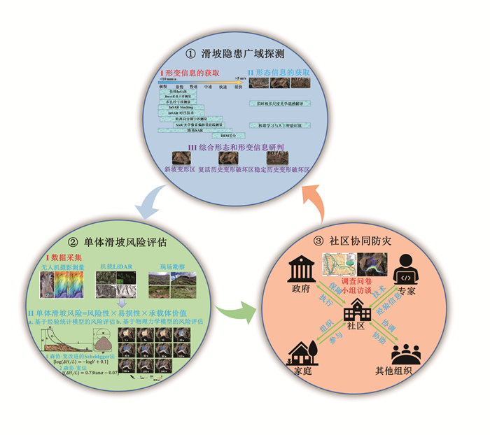
图 1 多源遥感的滑坡防灾技术框架
Fig. 1. The multi⁃source remote sensing technical framework for landslide prevention
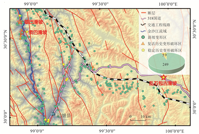
图 2 青藏高原交通工程关键区段滑坡隐患的分布
Fig. 2. Distribution of potential landslides in the key section of the Qinghai⁃Tibet Plateau Transportation Project (QTPTP)
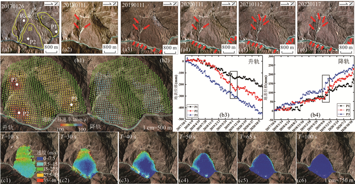
图 3 贡巴滑坡的形态(a)和形变(b)信息,以及基于物理力学模型的滑坡失稳模拟(c)
Fig. 3. The geomorphological (a) and deformation (b) information of the Gongba landslide, and landslide failure simulation based on a physical and mechanical model (c)
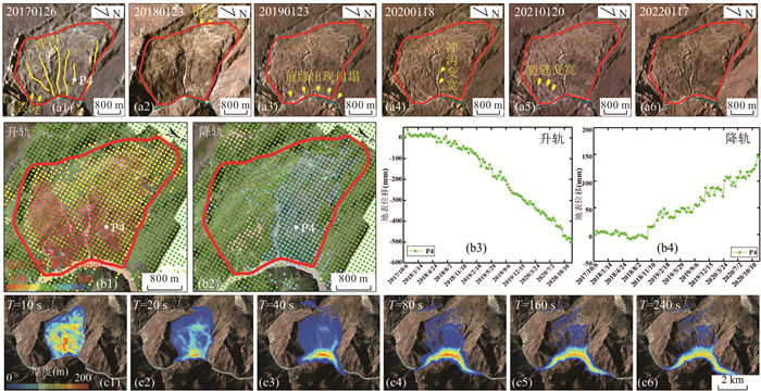
图 4 雄巴滑坡的地貌形态(a)和地表形变(b)信息,以及基于物理力学模型的滑坡失稳模拟(c)
滑坡失稳模拟改编自Yao et al.(2022)
Fig. 4. The geomorphological (a) and surface displacement (b) information of the Xiongba landslide, and landslide failure simulation based on a physical and mechanical model (c)
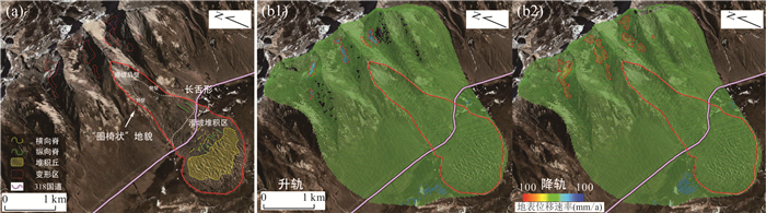
图 5 乱石包滑坡的地貌形态和地表形变信息
Fig. 5. The geomorphological and surface displacement information of the Luanshibao landslide
表 1 滑坡隐患分类及识别方法
Table 1. Potential landslide types and their corresponding identification methods
滑坡隐患类型 斜坡变形区 复活历史变形破坏区 稳定历史变形破坏区 潜在斜坡变形区 示意图 


识别指标 可能存在裂缝、前缘小规模崩塌等形态信息,有形变信息 呈现圈椅状、存在滑坡后壁、滑坡侧壁、多级台坎,有形变信息 呈现圈椅状、存在滑坡后壁、滑坡侧壁、多级台坎,无形变信息 无形态或形变信息 识别方法 光学卫星影像解译、InSAR技术、POT技术 光学卫星影像解译、InSAR技术、POT技术 光学卫星影像解译 航空物探、钻探  下载: 导出CSV
-
Amatya, P., Kirschbaum, D., Stanley, T., et al., 2021. Landslide Mapping Using Object-Based Image Analysis and Open Source Tools. Engineering Geology, 282: 106000. https://doi.org/10.1016/j.enggeo.2021.106000 Bechor, N. B. D., Zebker, H. A., 2006. Measuring Two-Dimensional Movements Using a Single InSAR Pair. Geophysical Research Letters, 33(16): L16311. https://doi.org/10.1029/2006gl026883 Behling, R., Roessner, S., Golovko, D., et al., 2016. Derivation of Long-Term Spatiotemporal Landslide Activity—A Multi-Sensor Time Series Approach. Remote Sensing of Environment, 186: 88-104. https://doi.org/10.1016/j.rse.2016.07.017 Berardino, P., Fornaro, G., Lanari, R., et al., 2002. A New Algorithm for Surface Deformation Monitoring Based on Small Baseline Differential SAR Interferograms. IEEE Transactions on Geoscience and Remote Sensing, 40(11): 2375-2383. https://doi.org/10.1109/tgrs.2002.803792 Casu, F., Manconi, A., Pepe, A., et al., 2011. Deformation Time-Series Generation in Areas Characterized by Large Displacement Dynamics: The SAR Amplitude Pixel-Offset SBAS Technique. IEEE Transactions on Geoscience and Remote Sensing, 49(7): 2752-2763. https://doi.org/10.1109/tgrs.2010.2104325 Chen, W. T., Li, X. J., Wang, Y. X., et al., 2014. Forested Landslide Detection Using LiDAR Data and the Random Forest Algorithm: A Case Study of the Three Gorges, China. Remote Sensing of Environment, 152: 291-301. https://doi.org/10.1016/j.rse.2014.07.004 Chowdhury, R., Flentje, P., 2003. Role of Slope Reliability Analysis in Landslide Risk Management. Bulletin of Engineering Geology and the Environment, 62(1): 41-46. https://doi.org/10.1007/s10064-002-0166-1 Comert, R., Avdan, U., Gorum, T., et al., 2019. Mapping of Shallow Landslides with Object-Based Image Analysis from Unmanned Aerial Vehicle Data. Engineering Geology, 260: 105264. https://doi.org/10.1016/j.enggeo.2019.105264 Cruden, D. M., Varnes, D. J., 1996. Landslide Types and Processes. Landslides: Investigation and Mitigation, 247: 36-75 Dai, K. R., Li, Z. H., Xu, Q., et al., 2020. Entering the Era of Earth Observation-Based Landslide Warning Systems: A Novel and Exciting Framework. IEEE Geoscience and Remote Sensing Magazine, 8(1): 136-153. https://doi.org/10.1109/mgrs.2019.2954395 Danneels, G., Pirard, E., Havenith, H. B., 2007. Automatic Landslide Detection from Remote Sensing Images Using Supervised Classification Methods. 2007 IEEE International Geoscience and Remote Sensing Symposium, Barcelona, Spain, 3014-3017. https://doi.org/10.1109/igarss.2007.4423479 Evans, S. G., 2006. The Formation and Failure of Landslide Dams: An Approach to Risk Assessment. Italian Journal of Engineering Geology and Environment, 1: 15-20 Ferretti, A., Prati, C., Rocca, F. L., 1999. Permanent Scatterers in SAR Interferometry. Remote Sensing. Proceedings Volume 3869, SAR Image Analysis, Modeling, and Techniques Ⅱ, Florence, Italy, 139-145. https://doi.org/10.1117/12.373150 Ferretti, A., Prati, C., Rocca, F., 2000. Nonlinear Subsidence Rate Estimation Using Permanent Scatterers in Differential SAR Interferometry. IEEE Transactions on Geoscience and Remote Sensing, 38(5): 2202-2212. https://doi.org/10.1109/36.868878 Ferretti, A., Prati, C., Rocca, F., 2001. Permanent Scatterers in SAR Interferometry. IEEE Transactions on Geoscience and Remote Sensing. 39(1): 8-20. https://doi.org/10.1109/36.898661 Ge, D. Q., Dai, K. R., Guo, Z. C., et al., 2019. Early Identification of Serious Geological Hazards with Integrated Remote Sensing Technologies: Thoughts and Recommendations. Geomatics and Information Science of Wuhan University, 44(7): 949-956(in Chinese with English abstract) Ghorbanzadeh, O., Blaschke, T., Gholamnia, K., et al., 2019. Evaluation of Different Machine Learning Methods and Deep-Learning Convolutional Neural Networks for Landslide Detection. Remote Sensing, 11(2): 196. https://doi.org/10.3390/rs11020196 Gorsevski, P. V., Brown, M. K., Panter, K., et al., 2016. Landslide Detection and Susceptibility Mapping Using LiDAR and an Artificial Neural Network Approach: A Case Study in the Cuyahoga Valley National Park, Ohio. Landslides, 13(3): 467-484. https://doi.org/10.1007/s10346-015-0587-0 Grandin, R., Klein, E., Métois, M., et al., 2016. Three-Dimensional Displacement Field of the 2015 Mw8.3 Illapel Earthquake (Chile) from across- and along-Track Sentinel-1 TOPS Interferometry. Geophysical Research Letters, 43(6): 2552-2561. https://doi.org/10.1002/2016gl067954 Guo, C. B., Zhang, Y. S., Montgomery, D. R., et al., 2016. How Unusual is the Long-Runout of the Earthquake-Triggered Giant Luanshibao Landslide, Tibetan Plateau, China? Geomorphology, 259: 145-154. https://doi.org/10.1016/j.geomorph.2016.02.013 Hungr, O., 1995. A Model for the Runout Analysis of Rapid Flow Slides, Debris Flows, and Avalanches. Canadian Geotechnical Journal, 32(4): 610-623. https://doi.org/10.1139/t95-063 Hungr, O., Corominas, J., Eberhardt, E., 2005. Estimating Landslide Motion Mechanisms, Travel Distance and Velocity. Landslide Risk Management, London, 1: 109-138. Hungr, O., Leroueil, S., Picarelli, L., 2014. The Varnes Classification of Landslide Types, an Update. Landslides, 11(2): 167-194. https://doi.org/10.1007/s10346-013-0436-y Ji, S. P., Yu, D. W., Shen, C. Y., et al., 2020. Landslide Detection from an Open Satellite Imagery and Digital Elevation Model Dataset Using Attention Boosted Convolutional Neural Networks. Landslides, 17(6): 1337-1352. https://doi.org/10.1007/s10346-020-01353-2 Ju, Y. Z., Xu, Q., Jin, S. C., et al., 2022. Loess Landslide Detection Using Object Detection Algorithms in Northwest China. Remote Sensing, 14(5): 1182. https://doi.org/10.3390/rs14051182 Keyport, R. N., Oommen, T., Martha, T. R., et al., 2018. A Comparative Analysis of Pixel- and Object-Based Detection of Landslides from Very High-Resolution Images. International Journal of Applied Earth Observation and Geoinformation, 64: 1-11. https://doi.org/10.1016/j.jag.2017.08.015 Langhammer, L., Rabenstein, L., Schmid, L., et al., 2019. Glacier Bed Surveying with Helicopter-Borne Dual-Polarization Ground-Penetrating Radar. Journal of Glaciology, 65(249): 123-135. https://doi.org/10.1017/jog.2018.99 Lee, E. M., 2009. Landslide Risk Assessment: The Challenge of Estimating the Probability of Landsliding. Quarterly Journal of Engineering Geology and Hydrogeology, 42(4): 445-458. https://doi.org/10.1144/1470-9236/08-007 Leprince, S., Ayoub, F., Klinger, Y., et al., 2007. Co-Registration of Optically Sensed Images and Correlation (COSI-Corr): An Operational Methodology for Ground Deformation Measurements. 2007 IEEE International Geoscience and Remote Sensing Symposium. Barcelona, Spain, 1943-1946. https://doi.org/10.1109/igarss.2007.4423207 Li, S. H., Liu, T. P., Liu, X. Y., 2009. Analysis Method for Landslide Stability. Chinese Journal of Rock Mechanics and Engineering, 28(Suppl. 2): 3309-3324(in Chinese with English abstract) Li, W. L., Xu, Q., Lu, H. Y., et al., 2019. Tracking the Deformation History of Large-Scale Rocky Landslides and Its Enlightenment. Geomatics and Information Science of Wuhan University, 44(7): 1043-1053(in Chinese with English abstract). Li, Z. B., Shi, W. Z., Myint, S. W., et al., 2016. Semi-Automated Landslide Inventory Mapping from Bitemporal Aerial Photographs Using Change Detection and Level Set Method. Remote Sensing of Environment, 175: 215-230. https://doi.org/10.1016/j.rse.2016.01.003 Li, Z. H., 2005. Correction of Atmospheric Water Vapour Effects on Repeat-Pass SAR Interferometry Using GPS, MODIS and MERIS Data (Dissertation). University of London, London. Li, Z. H., Fielding, E. J., Cross, P., 2009. Integration of InSAR Time-Series Analysis and Water-Vapor Correction for Mapping Postseismic Motion after the 2003 Bam (Iran) Earthquake. IEEE Transactions on Geoscience and Remote Sensing, 47(9): 3220-3230. https://doi.org/10.1109/tgrs.2009.2019125 Li, Z. H., Li, P., Ding, D., et al., 2018. Research Progress of Global High Resolution Digital Elevation Models. Geomatics and Information Science of Wuhan University, 43(12): 1927-1942(in Chinese with English abstract). Li, Z. H., Song, C., Yu, C., et al., 2019. Application of Satellite Radar Remote Sensing to Landslide Detection and Monitoring: Challenges and Solutions. Geomatics and Information Science of Wuhan University, 44(7): 967-979(in Chinese with English abstract). Lu, P., Qin, Y. Y., Li, Z. B., et al., 2019. Landslide Mapping from Multi-Sensor Data through Improved Change Detection-Based Markov Random Field. Remote Sensing of Environment, 231: 111235. https://doi.org/10.1016/j.rse.2019.111235 Lü, Z. Y., Shi, W. Z., Zhang, X. K., et al., 2018. Landslide Inventory Mapping from Bitemporal High-Resolution Remote Sensing Images Using Change Detection and Multiscale Segmentation. IEEE Journal of Selected Topics in Applied Earth Observations and Remote Sensing, 11(5): 1520-1532. https://doi.org/10.1109/jstars.2018.2803784 Luo, H. B., Li, Z. H., Chen, J. J., et al., 2019. Integration of Range Split Spectrum Interferometry and Conventional InSAR to Monitor Large Gradient Surface Displacements. International Journal of Applied Earth Observation and Geoinformation, 74: 130-137. https://doi.org/10.1016/j.jag.2018.09.004 Martha, T. R., Kerle, N., van Westen, C. J., et al., 2011. Segment Optimization and Data-Driven Thresholding for Knowledge-Based Landslide Detection by Object-Based Image Analysis. IEEE Transactions on Geoscience and Remote Sensing, 49(12): 4928-4943. https://doi.org/10.1109/tgrs.2011.2151866 Massonnet, D., Feigl, K. L., 1998. Radar Interferometry and Its Application to Changes in the Earth's Surface. Reviews of Geophysics, 36(4): 441-500. https://doi.org/10.1029/97rg03139 Moon, K., Blackman, D., 2014. A Guide to Understanding Social Science Research for Natural Scientists. Conservation Biology, 28(5): 1167-1177. https://doi.org/10.1111/cobi.12326 Morishita, Y., Lazecky, M., Wright, T., et al., 2020. LiCSBAS: An Open-Source InSAR Time Series Analysis Package Integrated with the LiCSAR Automated Sentinel-1 InSAR Processor. Remote Sensing, 12(3): 424. https://doi.org/10.3390/rs12030424 Othman, A., Gloaguen, R., 2013. Automatic Extraction and Size Distribution of Landslides in Kurdistan Region, NE Iraq. Remote Sensing, 5(5): 2389-2410. https://doi.org/10.3390/rs5052389 Oyasu, K., 2019. Community Based Learning for Sustainable Development. Kult-Ur Revista Interdisciplinària Sobre La Cultura De La Ciutat, 6(11): 39-62. https://doi.org/10.6035/kult-ur.2019.6.11.2 Rosen, P. A., Hensley, S., Joughin, I. R., et al., 2000. Synthetic Aperture Radar Interferometry. Proceedings of the IEEE, 88(3): 333-382. https://doi.org/10.1109/5.838084 Shi, W. Z., Zhang, M., Ke, H. F., et al., 2021. Landslide Recognition by Deep Convolutional Neural Network and Change Detection. IEEE Transactions on Geoscience and Remote Sensing, 59(6): 4654-4672. https://doi.org/10.1109/tgrs.2020.3015826 Shi, X. G., Zhang, L., Balz, T., et al., 2015. Landslide Deformation Monitoring Using Point-Like Target Offset Tracking with Multi-Mode High-Resolution TerraSAR-X Data. ISPRS Journal of Photogrammetry and Remote Sensing, 105: 128-140. https://doi.org/10.1016/j.isprsjprs.2015.03.017 Sim, T., Dominelli, L., Lau, J., 2017. A Pathway to Initiate Bottom-up Community-Based Disaster Risk Reduction within a Top-down System: The Case of China. International Journal of Safety and Security Engineering, 7(3): 283-293. https://doi.org/10.2495/safe-v7-n3-283-293 Singleton, A., Li, Z., Hoey, T., et al., 2014. Evaluating Sub-Pixel Offset Techniques as an Alternative to D-InSAR for Monitoring Episodic Landslide Movements in Vegetated Terrain. Remote Sensing of Environment, 147: 133-144. https://doi.org/10.1016/j.rse.2014.03.003 van den Eeckhaut, M., Kerle, N., Poesen, J., et al., 2012. Object-Oriented Identification of Forested Landslides with Derivatives of Single Pulse LiDAR Data. Geomorphology, 173-174: 30-42. https://doi.org/10.1016/j.geomorph.2012.05.024 Varnes, D. J., 1984. Landslide Hazard Zonation: A Review of Principles and Practice. UNESCO, Paris, 3. Wang, N. Q., Zhang, Z. Y., Wang, J. D., 2003. A Forecasting Method of Sliding Distance on Typical Loess Landslides. Journal of Northwest University (Natural Science Edition), 33(1): 111-114(in Chinese with English abstract). Wang, Z., Li, Z., Liu, Y., et al., 2019. A New Processing Chain for Real-Time Ground-Based SAR (RT-GBSAR) Deformation Monitoring. Remote Sensing, 11(20): 2437. Wu, S. R., Shi, J. S., Zhang, C. S., et al., 2009. Preliminary Discussion on Technical Guideline for Geohazard Risk Assessment. Geological Bulletin of China, 28(8): 995-1005(in Chinese with English abstract). Wu, Y., Liu, D. S., Lu, X., et al., 2011. Vulnerability Assessment Model for Hazard Bearing Body and Landslide Risk Index. Rock and Soil Mechanics, 32(8): 2487-2492, 2499(in Chinese with English abstract) Wu, Z. F., 2009. The Study of Interpretation of Large-Scale Landslides and Hazard Assessment in Wulong County Based on RS and GIS (Dissertation). Southwest University, Chongqing(in Chinese with English abstract). Xiao, R. Y., Yu, C., Li, Z. H., et al., 2020. General Survey of Large-Scale Land Subsidence by GACOS-Corrected InSAR Stacking: Case Study in North China Plain. Proceedings of the International Association of Hydrological Sciences, 382: 213-218. https://doi.org/10.5194/piahs-382-213-2020 Xiong, S. Q., 2009. The Strategic Consideration of the Development of China's Airborne Geophysical Technology. Geology in China, 36(6): 1366-1374(in Chinese with English abstract). Xu, Q., Dong, X. J., Li, W. L., 2019. Integrated Space-Air-Ground Early Detection, Monitoring and Warning System for Potential Catastrophic Geohazards. Geomatics and Information Science of Wuhan University, 44(7): 957-966(in Chinese with English abstract). Xu, W. Y., Zhang, Z. T., 1995. Study on Landslide Failure Probability and Reliability. Journal of Catastrophology, 10(4): 33-37(in Chinese with English abstract). Yao, J. M., Lan, H. X., Li, L. P., et al., 2022. Characteristics of a Rapid Landsliding Area along Jinsha River Revealed by Multi-Temporal Remote Sensing and Its Risks to Sichuan-Tibet Traffic Corridor. Landslides, 19(3): 703-718. https://doi.org/10.1007/s10346-021-01790-7 Yu, C., Li, Z. H., Penna, N. T., 2018a. Interferometric Synthetic Aperture Radar Atmospheric Correction Using a GPS-Based Iterative Tropospheric Decomposition Model. Remote Sensing of Environment, 204: 109-121. https://doi.org/10.1016/j.rse.2017.10.038 Yu, C., Li, Z. H., Penna, N. T., et al., 2018b. Generic Atmospheric Correction Model for Interferometric Synthetic Aperture Radar Observations. Journal of Geophysical Research: Solid Earth, 123(10): 9202-9222. https://doi.org/10.1029/2017jb015305 Yu, C., Li, Z. H., Penna, N. T., 2020. Triggered Afterslip on the Southern Hikurangi Subduction Interface Following the 2016 Kaikōura Earthquake from InSAR Time Series with Atmospheric Corrections. Remote Sensing of Environment, 251: 112097. https://doi.org/10.1016/j.rse.2020.112097 Yu, C., Penna, N. T., Li, Z. H., 2017. Generation of Real-Time Mode High-Resolution Water Vapor Fields from GPS Observations. Journal of Geophysical Research: Atmospheres, 122(3): 2008-2025. https://doi.org/10.1002/2016jd025753 Zhong, C., Liu, Y., Gao, P., et al., 2020. Landslide Mapping with Remote Sensing: Challenges and Opportunities. International Journal of Remote Sensing, 41(4): 1555-1581. https://doi.org/10.1016/j.rse.2020.112097 Zhuang, J. Q., Peng, J. B., Wang, G. H., et al., 2018. Distribution and Characteristics of Landslide in Loess Plateau: A Case Study in Shaanxi Province. Engineering Geology, 236: 89-96. https://doi.org/10.1016/j.enggeo.2017.03.001 葛大庆, 戴可人, 郭兆成, 等, 2019. 重大地质灾害隐患早期识别中综合遥感应用的思考与建议. 武汉大学学报(信息科学版), 44(7): 949-956. 李世海, 刘天苹, 刘晓宇, 2009. 论滑坡稳定性分析方法. 岩石力学与工程学报, 28(增刊2): 3309-3324. 李为乐, 许强, 陆会燕, 等, 2019. 大型岩质滑坡形变历史回溯及其启示. 武汉大学学报(信息科学版), 44(7): 1043-1053. 李振洪, 李鹏, 丁咚, 等, 2018. 全球高分辨率数字高程模型研究进展与展望, 武汉大学学报(信息科学版), 43(12): 1927-1942. 李振洪, 宋闯, 余琛, 等, 2019. 卫星雷达遥感在滑坡灾害探测和监测中的应用: 挑战与对策. 武汉大学学报(信息科学版), 44(7): 967-979. 王念秦, 张倬元, 王家鼎, 2003. 一种典型黄土滑坡的滑距预测方法. 西北大学学报(自然科学版), 33(1): 111-114. 吴树仁, 石菊松, 张春山, 等, 2009. 地质灾害风险评估技术指南初论. 地质通报, 28(8): 995-1005. 吴越, 刘东升, 陆新, 等, 2011. 承灾体易损性评估模型与滑坡灾害风险度指标. 岩土力学, 32(8): 2487-2492, 2499. 吴忠芳, 2009. RS和GIS技术支持下的武隆县大型滑坡遥感解译及其危险性评价(硕士学位论文). 重庆: 西南大学. 熊盛青, 2009. 发展中国航空物探技术有关问题的思考. 中国地质, 36(6): 1366-1374. 许强, 2018. 构建新"三查"体系, 创新地灾防治新机制. http://www.zgkyb.com/yw/20180312_48669.htm 许强, 2020. 对地质灾害隐患早期识别相关问题的认识与思考. 武汉大学学报(信息科学版), 45(11): 1651-1659 许强, 董秀军, 李为乐, 2019. 基于天-空-地一体化的重大地质灾害隐患早期识别与监测预警. 武汉大学学报(信息科学版), 44(7): 957-966. 许强, 陆会燕, 李为乐, 等, 2022. 滑坡隐患类型与对应识别方法. 武汉大学学报(信息科学版), 47(3): 377-387. 徐卫亚, 张志腾, 1995. 滑坡失稳破坏概率及可靠度研究. 灾害学, (4): 33-37. 殷坤龙, 张宇, 汪洋, 2022. 水库滑坡涌浪风险研究现状和灾害链风险管控实践. 地质科技通报, 41(2): 1-12. 殷跃平, 2018. 全面提升地质灾害防灾减灾科技水平. 中国地质灾害与防治学报, 29(5): 3 张成龙, 李振洪, 余琛, 等, 2021. 利用GACOS辅助下InSAR Stacking对金沙江流域进行滑坡监测. 武汉大学学报(信息科学版), 46(11): 1649-1657. 张东明, 李剑锋, 田贵维, 等, 2011. 基于GIS和RS的重庆市滑坡遥感解译. 自然灾害学报, 20(2): 56-61. -

 点击查看大图
计量
- 文章访问数: 6382
- HTML全文浏览量: 2912
- PDF下载量: 388
- 被引次数: 0
