


Modeling of Debris Flow Susceptibility Assessment in Tianshan Based on Watershed Unit and Stacking Ensemble Algorithm
-
摘要: 天山地区未来将成为国家重要战略交通、油气资源管道、城镇居民点建设的部署区域,对该区域泥石流灾害易发性评估使重大潜在泥石流灾害点的监测点布置以及防治更具针对性.集成学习算法可避免灾害易发性评估中算法选择困难的问题且可显著提高建模精度,但其在泥石流易发性评估中的应用仍然缺乏,可靠性有待检验.本研究基于流域单元采用堆叠集成算法评估天山地区的泥石流灾害易发性,选择干旱度、陡度指数等14个特征变量进行天山地区的泥石流易发性评估建模,比较了堆叠集成算法与独立异质算法建模的预测性能,最后探讨了天山地区泥石流灾害的控制因素.结果表明:(1)天山地区泥石流灾害高、极高易发性区域占比分别为17.06%和19.75%,集中分布在北天山北坡和南天山南坡.(2)堆叠集成算法预测率曲线AUC值为0.87,显著高于独立机器学习算法(0.79~0.81),比独立机器学习算法有更好的预测性能.(3)除去常规地形和降雨对天山地区泥石流的发育有显著控制作用外,干旱和隆升也对天山地区泥石流的发育有重要影响.结果不仅有助于天山地区泥石流灾害风险管理,还对各类机器学习模型评估干旱山区泥石流易发性的建模特征有启示意义.Abstract: The Tianshan Mountain and its surrounding areas will become the deployment areas of national important strategic transportation, oil and gas resources pipelines, and urban settlement construction in the future. The risk prediction and assessment of debris flow disasters in the region will make the monitoring layout and prevention of major potential debris flow disaster points more targeted. The ensemble learning algorithm can avoid the difficulty of algorithm selection in disaster susceptibility assessment and significantly improve the modeling accuracy. However, its application in debris flow susceptibility assessment is still limited and its reliability needs to be tested. In this paper, the stacking ensemble algorithm was used to evaluate and predict the susceptibility of debris flow disasters in the Tianshan Mountain. Considering 14 characteristic variables such as drought degree and steepness index, the prediction performance of the stacking ensemble algorithm and the independent heterogeneous algorithm was compared. Finally, the control factors of debris flow disasters in the Tianshan area are discussed. The results show follows: (1) The areas with high debris flow disaster and extremely high susceptibility to debris flow in the Tianshan area account for 17.06% and 19.75%, respectively, and are concentrated on the northern slope of the North Tianshan and the southern slope of the South Tianshan. (2) The AUC value of the prediction rate curve of the stacked ensemble algorithm is 0.87, which is significantly higher than that of the independent machine learning algorithm (0.79-0.81) and has better prediction performance than the independent machine learning algorithm. (3) In addition to conventional topography and rainfall, which have significant control on the formation of debris flows in the Tianshan area, drought and uplift have important effects on the formation of debris flow in the Tianshan area. The results of this paper not only contribute to the risk management of debris flow disasters in the Tianshan area but also have implications for the assessment of debris flow susceptibility in arid mountainous areas.
-
Key words:
- Tianshan /
- debris flow /
- machine learning /
- susceptibility /
- drought /
- uplift /
- hazard geology
-

图 1 研究区域的地理位置、高程和主要断层线
Fig. 1. Geographical location, elevation, and major fault lines of the study area
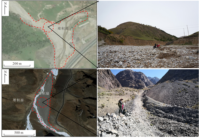
图 3 遥感影像和野外调查泥石流灾害的对比
Fig. 3. Comparison between remote sensing image and field investigation of the debris flow disaster
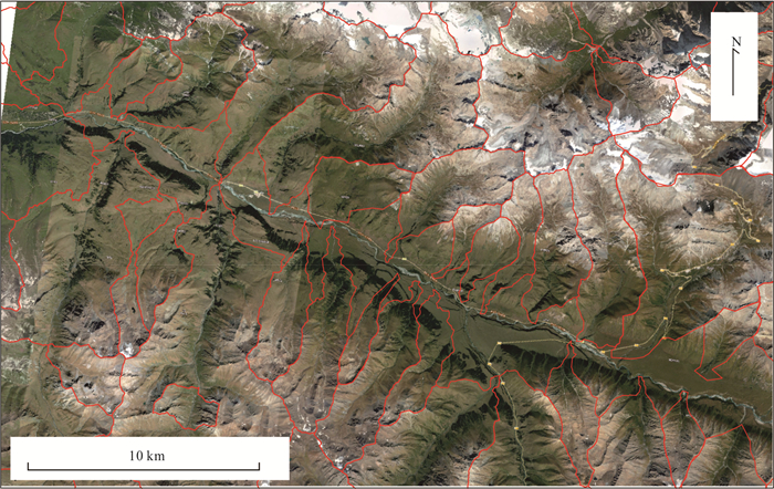
图 4 GIS提取的流域面积大于1 km2的流域单元
Fig. 4. Watershed units with an area larger than 1 km2 extracted on GIS platform
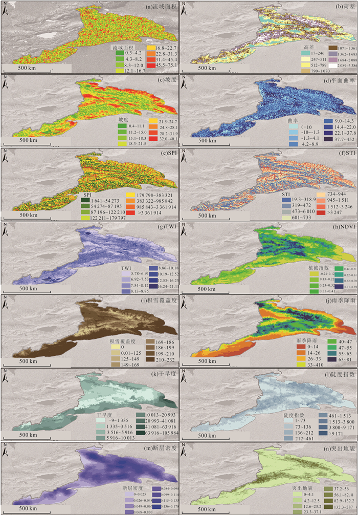
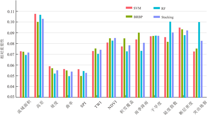
图 5 研究中与泥石流相关的14个特征变量
a到n依次表示流域面积、高差、坡度、曲率、径流强度指数(SPI)、输沙指数(STI)、土壤湿度指数(TWI)、归一化植被指数(NDVI)、积雪覆盖度、雨季降雨量、干旱度、陡度指数、断层密度、突出地貌
Fig. 5. The 14 characteristic variables related to debris flow used in the study
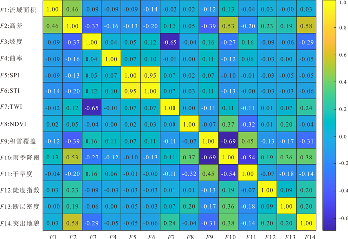
图 7 特征变量之间的泊松相关系数
Fig. 7. Poisson correlation coefficient between characteristic variables
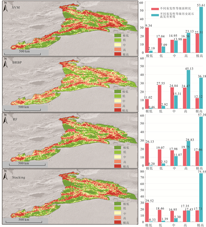
图 8 基于四种机器学习算法的泥石流灾害易发性
Fig. 8. Susceptibility of debris flow disasters based on four machine learning algorithms
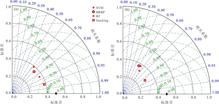
图 9 不同算法在训练集(a)和测试集(b)预测结果与实际观测结果的关联性
Fig. 9. Correlation between predicted and observed results of different algorithms in training dataset (a) and testing dataset (b)

图 10 四种算法的在训练集(a)和测试集中(b)的ROC曲线
Fig. 10. ROC curves of four algorithms in training data set (a) and testing data set (b)
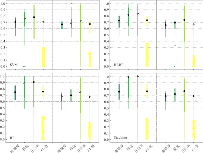
图 11 四种算法预测泥石流易发性的性能参数
a~d. 准确度、精度、召回率、F1-score
Fig. 11. The performance parameters of the four algorithms in predicting debris flow susceptibility
表 1 本研究选取的特征变量
Table 1. The characteristic variables selected in this study
因素 影响因素与泥石流风险相关性及释义 备注 SPI 径流强度指数(SPI)可以衡量水流侵蚀的能力,其计算公式为:SPI=α×tanβ,式中:$ \partial $为某点汇流面积(m2);β为坡度(°). 基础数据为SRTM-30 m DEM,在GIS平台计算、分析、提取获得. STI 输沙指数(STI)是指河流和地下水等运送沙土颗粒等的能力,输沙指数高的时候,水土流失较为严重.其计算公式为$ \mathrm{S}\mathrm{T}\mathrm{I}={\left(\frac{\alpha }{22.13}\right)}^{0.6}\times \mathrm{s}\mathrm{i}\mathrm{n}{\left(\frac{\beta }{0.089\mathrm{ }6}\right)}^{1.3} $,式中:$ \partial $为某点汇流面积(m2);β为坡度(°). TWI 地形湿度指数可以表征流域内土壤水分的干湿状况, 其计算公式为:$ \mathrm{T}\mathrm{W}\mathrm{I}=\mathrm{l}\mathrm{n}\left(\alpha /\beta \right) $,式中:$ \partial $为某点汇流面积(m2);β为坡度(°). NDVI 归一化植指数(NDVI)反映植被覆盖程度.其计算公式为:$ \mathrm{N}\mathrm{D}\mathrm{V}\mathrm{I}=(\mathrm{N}\mathrm{I}\mathrm{R}-R)/(\mathrm{N}\mathrm{I}\mathrm{R}+R) $,式中,NIR为近红外波段的反射值,R为红光波段的反射值. 时间跨度为1990‒2020年,分辨率为500 m,来源于MODIAS( https://modis.gsfc.nasa.gov/data/dataprod/mod13.php ).积雪覆盖度 积雪覆盖程度指的是单位面积内积雪面积,对泥石流的形成有重要作用,尤其是冰雪融水型泥石流. 时间跨度为1970‒2010年,分辨率为500 m,来源于国家冰川冻土沙漠科学数据中心( http://www.ncdc.ac.cn/portal/ ).雨季降雨 雨季降雨指的是每年5‒9月份的总降雨量,是泥石流灾害形成的激发因素. 时间跨度为1970‒2020年,分辨率为500 m, 来源于青藏高原科学数据中( https://data.tpdc.ac.cn/zh-hans/ ).干燥指数 干燥指数是用来衡量气候干燥程度的指标,用地面失水(如蒸发、径流)与供水的比值表示.干旱会造成表面土体开裂,促进降雨渗入坡面,利于泥石流的形成. 分辨率为500 m,来源于中国科学院资源环境科学与数据中心( https://www.resdc.cn/Default.aspx ).陡度 河流陡度指数(ksn),反映河道纵剖面的整体陡峭程度,高陡度指数代表高的隆升速率.其计算公式为:$ {k}_{\mathrm{s}\mathrm{n}}={\left(\frac{S}{A}\right)}^{\theta } $,式中,S为河段坡度,A为汇流面积,θ是凹度指数,通常取值为0.45. 基础数据为SRTM-30 m DEM,在GIS平台计算、分析、提取获得. 断层密度 断层影响基岩的破碎程度,针对线性特征变量,断层线密度反映单位面积内的断层线长度(Huang et al., 2022). 由国家1:100万地质图数字化获得. 突出地貌 地貌突出高度ZE是用来计算地形表面z和理想地形z'之间的岩石高度.ZE越大,表示发生滑坡的概率越大,潜在物源越多(Blöthe et al., 2015).其计算公式为$ {Z}_{E}=z-\mathrm{m}\mathrm{i}{\mathrm{n}}_{(s, t)\in (-\mathrm{\infty }, \mathrm{\infty })}\left\{z(x+s, y+t)+{s}_{t}\sqrt{{s}^{2}+{t}^{2}}\right\} $,式中,s和t指的是到窗口中心的基数距离,st是阈值坡度角,本研究中取值为30°. 基础数据为SRTM-30 m DEM,在GIS平台计算、分析、提取获得.  下载: 导出CSV
表 2 特征变量的膨胀系数和公差
Table 2. Variance inflation factor and tolerance of the characteristic variables
特征变量 VIF TOL VIF(去除STI后) TOL(去除STI后) 流域面积 1.46 0.69 1.45 0.69 高差 2.89 0.35 2.86 0.35 坡度 2.25 0.44 2.14 0.47 曲率 1.05 0.96 1.04 0.96 SPI 12.45 0.08 1.05 0.96 STI 13.01 0.08 \ \ TWI 1.96 0.51 1.92 0.52 植被指数 1.37 0.73 1.37 0.73 积雪覆盖 2.18 0.46 2.17 0.46 雨季降雨 3.47 0.29 3.47 0.29 干旱度 1.53 0.65 1.52 0.66 陡度指数 1.08 0.93 1.08 0.93 断层密度 1.20 0.83 1.19 0.84 突出地貌 1.83 0.55 1.82 0.55
下载: 导出CSV
-
Altmann, A., Tolo, L. I., 2010. Permutation Importance. Bioinformatics, 26(10): 1340-1347. doi: 10.1093/bioinformatics/btq134 Band, S. S., Janizadeh, S., Pal, S. C., et al., 2020. Flash Flood Susceptibility Modeling Using New Approaches of Hybrid and Ensemble Tree-Based Machine Learning Algorithms. Remote Sensing, 12(3568): 3568. http://www.sciencedirect.com/science/article/pii/S0022169420304674 Blais-Stevens, A., Behnia, P., Kremer, M., et al., 2012. Landslide Susceptibility Mapping of the Sea to Sky Transportation Corridor, British Columbia, Canada: Comparison of Two Methods. Bulletin of Engineering Geology and the Environment, 71(3): 447-466. doi: 10.1007/s10064-012-0421-z Blöthe, J. H., Korup, O., Schwanghart, W., 2015. Large Landslides Lie Low: Excess Topography in the Himalaya-Karakoram Ranges. Geology, 43(6): 523-526. doi: 10.1130/G36527.1 Carrara, A., Crosta, G., Frattini, P., 2008. Comparing Models of Debris-Flow Susceptibility in the Alpine Environment. Geomorphology, 94(3/4): 353-378. http://www.onacademic.com/detail/journal_1000035389459010_7c7a.html Chen, N. S., Tian, S. F., Zhang, Y., et al., 2021. Soil Mass Domination in Debris-Flow Disasters and Strategy for Hazard Mitigation. Earth Science Frontiers, 28(4): 337-348 (in Chinese with English abstract). Chen, N. S., Zhang, Y., Tian, S. F., et al., 2020a. Effectiveness Analysis of the Prediction of Regional Debris Flow Susceptibility in Post-Earthquake and Drought Site. Journal of Mountain Science, 17(2): 329-339. doi: 10.1007/s11629-019-5684-4 Chen, Y., Qin, S., Qiao, S., et al., 2020b. Spatial Predictions of Debris Flow Susceptibility Mapping Using Convolutional Neural Networks in Jilin Province, China. Water, 12(8): 2079. doi: 10.3390/w12082079 Chen, X., Chen, H., You, Y., et al., 2015. Susceptibility Assessment of Debris Flows Using the Analytic Hierarchy Process Method—A Case Study in Subao River Valley, China. Journal of Rock Mechanics and Geotechnical Engineering, 7(4): 404-410. doi: 10.1016/j.jrmge.2015.04.003 Chowdhuri, I., Pal, S. C., Chakrabortty, R., 2020. Flood Susceptibility Mapping by Ensemble Evidential Belief Function and Binomial Logistic Regression Model on River Basin of Eastern India. Advances in Space Research (the Official Journal of the Committee on Space Research (COSPAR)), 65(5): 1466-1489. doi: 10.1016/j.asr.2019.12.003 Dash, R. K., Falae, P. O., Kanungo, D. P., 2022. Debris Flow Susceptibility Zonation Using Statistical Models in Parts of Northwest Indian Himalayas—Implementation, Validation, and Comparative Evaluation. Natural Hazards, 111(2): 2011-2058. doi: 10.1007/s11069-021-05128-3 Dou, J., Yunus, A. P., Bui, D. T., et al., 2020. Improved Landslide Assessment Using Support Vector Machine with Bagging, Boosting, and Stacking Ensemble Machine Learning Framework in a Mountainous Watershed, Japan. Landslides, 17(3): 641-658. doi: 10.1007/s10346-019-01286-5 Handwerger, A. L., Huang, M. H., Fielding, E. J., et al., 2019. A Shift from Drought to Extreme Rainfall Drives a Stable Landslide to Catastrophic Failure. Scientific Reports, 9(1): 1569. doi: 10.1038/s41598-018-38300-0 He, Q., Wang, M., Liu, K., 2021. Rapidly Assessing Earthquake-Induced Landslide Susceptibility on a Global Scale Using Random Forest. Geomorphology, 391: 107889. doi: 10.1016/j.geomorph.2021.107889 Healey, S. P., Cohen, W. B., Yang, Z., et al., 2017. Mapping Forest Change Using Stacked Generalization: An Ensemble Approach. Remote Sensing of Environment, 204: 717-728. http://www.fs.usda.gov/treesearch/pubs/download/56397.pdf Hu, G. S., Shang, Y. J., Zeng, Q. L., et al., 2017. The Emergency Scientific Investigation of Catastrophic Debris Flow in Yecheng County of Xinjiang on July 6th, 2016. Mountain Research, 35(1): 112-116 (in Chinese with English abstract). Hu, R. J., Ma, H., Wu, R. S., et al., 1991. An Outline of Debris Flow in Xinjiang. Arid Land Geography, 14(2): 32-40 (in Chinese with English abstract). Huang, F. M., Cao, Y., Fan, X. M., et al., 2021a. Effects of Different Landslide Boundaries and Their Spatial Shapes on the Uncertainty of Landslide Susceptibility Prediction. Chinese Journal of Rock Mechanics and Engineering, 40(S02): 3227-3240 (in Chinese with English abstract). Huang, F. M., Chen, J. W., Tang, Z. P., et al., 2021b. Uncertainties of Landslide Susceptibility Prediction Due to Different Spatial Resolutions and Different Proportions of Training and Testing Datasets. Chinese Journal of Rock Mechanics and Engineering, 40(6): 1155-1169 (in Chinese with English abstract). Huang, F. M., Pan, L. H., Yao, C., et al., 2021c. Landslide Susceptibility Prediction Modelling Based on Semi- Supervised Machine Learning. Journal of Zhejiang University (Engineering Science), 55(9): 1705-1713 (in Chinese with English abstract). Huang, F. M., Pan, L., Fan, X., et al., 2022. The Uncertainty of Landslide Susceptibility Prediction Modeling: Suitability of Linear Conditioning Factors. Bulletin of Engineering Geology and the Environment, 81(5): 182. doi: 10.1007/s10064-022-02672-5 Huang, F. M., Wang, Y., Dong, Z. L., et al., 2019. Regional Landslide Susceptibility Mapping Based on Grey Relational Degree Model. Earth Science, 44(2): 664-676 (in Chinese with English abstract). http://en.cnki.com.cn/Article_en/CJFDTotal-DQKX201902027.htm Huang, F. M., Ye, Z., Yao, C., et al., 2020. Uncertainties of Landslide Susceptibility Prediction: Different Attribute Interval Divisions of Environmental Factors and Different Data-Based Models. Earth Science, 45(12): 4535-4549 (in Chinese with English abstract). Huang, F. M., Yin, K. L., Jiang, S. H., et al., 2018. Landslide Susceptibility Assessment Based on Clustering Analysis and Support Vector Machine. Chinese Journal of Rock Mechanics and Engineering, 37(1): 156-167 (in Chinese with English abstract). http://search.cnki.net/down/default.aspx?filename=YSLX201801016&dbcode=CJFD&year=2018&dflag=pdfdown Ilia, I., Tsangaratos, P., 2016. Applying Weight of Evidence Method and Sensitivity Analysis to Produce a Landslide Susceptibility Map. Landslides, 13(2): 379-397. doi: 10.1007/s10346-015-0576-3 Larsen, I. J., Montgomery, D. R., 2012. Landslide Erosion Coupled to Tectonics and River Incision. Nature Geoscience, 5(7): 468-473. doi: 10.1038/ngeo1479 Li, W. B., Fan, X. M., Huang, F. M., et al., 2021. Uncertainties of Landslide Susceptibility Modeling under Different Environmental Factor Connections and Prediction Models. Earth Science, 46(10): 3777-3795 (in Chinese with English abstract). http://www.sciencedirect.com/science/article/pii/S0341816221001090 Li, Y., Zhou, R. J., Zhao, G. H., et al., 2015. Uplift and Erosion Driven by Wenchuan Earthquake and Their Effects on Geomorphic Growth of Longmen Mountains: A Case Study of Hongchun Gully in Yingxiu, China. Journal of Chengdu University of Technology (Science & Technology Edition), 42(1): 5-17 (in Chinese with English abstract). doi: 10.3969/j.issn.1671-9727.2015.01.02 Nahayo, L., Kalisa, E., Maniragaba, A., et al., 2019. Comparison of Analytical Hierarchy Process and Certain Factor Models in Landslide Susceptibility Mapping in Rwanda. Modeling Earth Systems and Environment, 5(3): 885-895. doi: 10.1007/s40808-019-00575-1 Ouyang, C. J., Wang, Z. W., An, H. C., et al., 2019. An Example of a Hazard and Risk Assessment for Debris Flows—A Case Study of Niwan Gully, Wudu, China. Engineering Geology, 263(20): 105351. http://d.wanfangdata.com.cn/periodical/31d890cab0227589e60d623a783ed8d0 Rahman, M., Chen, N. S., Mahmud, G. I., et al., 2021. Flooding and Its Relationship with Land Cover Change, Population Growth, and Road Density. Geoscience Frontiers, 12(6): 16-35. http://www.sciencedirect.com/science/article/pii/S1674987121000888?utm_source=TrendMD&utm_medium=cpc Schrefler, B., Delage, P., 2013. Snow Avalanches. Environmental Geomechanics. Wiley, New York. Taylor, K. E., 2001. Summarizing Multiple Aspects of Model Performance in a Single Diagram. Journal of Geophysical Research Atmospheres, 106(D7): 7183-7192. doi: 10.1029/2000JD900719 Welsh, A., Davies, T., 2011. Identification of Alluvial Fans Susceptible to Debris-Flow Hazards. Landslides, 8(2): 183-194. doi: 10.1007/s10346-010-0238-4 Wolpert, D. H., 1992. Stacked Generalization. Neural Networks, 5(2): 241-259. doi: 10.1016/S0893-6080(05)80023-1 Xu, W., Yu, W., Jing, S., et al., 2013. Debris Flow Susceptibility Assessment by GIS and Information Value Model in a Large-Scale Region, Sichuan Province (China). Natural Hazards, 65(3): 1379-1392. doi: 10.1007/s11069-012-0414-z Zhang, S. H., Wu, G., 2019. Debris Flow Susceptibility and Its Reliability Based on Random Forest and GIS. Earth Science, 44(9): 3115-3134 (in Chinese with English abstract). http://en.cnki.com.cn/Article_en/CJFDTotal-DQKX201909025.htm 陈宁生, 田树峰, 张勇, 等, 2021. 泥石流灾害的物源控制与高性能减灾. 地学前缘, 28(4): 337-348. https://www.cnki.com.cn/Article/CJFDTOTAL-DXQY202104038.htm 胡桂胜, 尚彦军, 曾庆利, 等, 2017. 新疆叶城"7.6"特大灾害性泥石流应急科学调查. 山地学报, 35(1): 112-116. https://www.cnki.com.cn/Article/CJFDTOTAL-SDYA201701014.htm 胡汝骥, 马虹, 吴荣生, 等, 1991. 新疆境内的泥石流. 干旱区地理, 14(2): 32-40. https://www.cnki.com.cn/Article/CJFDTOTAL-GHDL199102005.htm 黄发明, 曹昱, 范宣梅, 等, 2021a. 不同滑坡边界及其空间形状对滑坡易发性预测不确定性的影响规律. 岩石力学与工程学报, 40(S02): 3227-3240. https://www.cnki.com.cn/Article/CJFDTOTAL-YSLX2021S2023.htm 黄发明, 陈佳武, 唐志鹏, 等, 2021b. 不同空间分辨率和训练测试集比例下的滑坡易发性预测不确定性. 岩石力学与工程学报, 40(6): 1155-1169. https://www.cnki.com.cn/Article/CJFDTOTAL-YSLX202106008.htm 黄发明, 潘李含, 姚池, 等, 2021c. 基于半监督机器学习的滑坡易发性预测建模. 浙江大学学报(工学版), 55(9): 1705-1713. https://www.cnki.com.cn/Article/CJFDTOTAL-ZDZC202109012.htm 黄发明, 汪洋, 董志良, 等, 2019. 基于灰色关联度模型的区域滑坡敏感性评价. 地球科学, 44(2): 664-676. doi: 10.3799/dqkx.2018.175 黄发明, 叶舟, 姚池, 等, 2020. 滑坡易发性预测不确定性: 环境因子不同属性区间划分和不同数据驱动模型的影响. 地球科学, 45(12): 4535-4549. doi: 10.3799/dqkx.2020.247 黄发明, 殷坤龙, 蒋水华, 等, 2018. 基于聚类分析和支持向量机的滑坡易发性评价. 岩石力学与工程学报, 37(1): 156-167. https://www.cnki.com.cn/Article/CJFDTOTAL-YSLX201801016.htm 李文彬, 范宣梅, 黄发明, 等, 2021. 不同环境因子联接和预测模型的滑坡易发性建模不确定性. 地球科学, 46(10): 3777-3795. doi: 10.3799/dqkx.2021.042 李勇, 周荣军, 赵国华, 等, 2015. 汶川地震驱动的隆升、剥蚀作用与龙门山地貌生长: 以映秀红椿沟为例. 成都理工大学学报(自然科学版), 42(1): 5-17. https://www.cnki.com.cn/Article/CJFDTOTAL-CDLG201501002.htm 张书豪, 吴光, 2019. 随机森林与GIS的泥石流易发性及可靠性. 地球科学, 44(9): 3115-3134. doi: 10.3799/dqkx.2019.081 -


 点击查看大图
计量
- 文章访问数: 1549
- HTML全文浏览量: 1002
- PDF下载量: 104
- 被引次数: 0
