


Machine Learning Solution for Landslide Susceptibility Based on Hydrographic Division: Case Study of Fengjie County in Chongqing
-
摘要: 三峡库区是地质灾害管理的重点地区,鉴于长江对其沿岸边坡的水力作用不容忽视,因此需进一步研究水系因素对滑坡易发性的影响.以重庆市奉节县为例,考虑区域内水系影响显著,沿水域两岸300 m区域内划分为分区Ⅰ,其余区域为分区Ⅱ.其次,全域、分区Ⅰ、分区Ⅱ以提取的16个影响因子建立易发性评价指标分析模型,基于随机森林模型计算区域滑坡发生概率,并将全域和分区的滑坡易发性评价结果对比分析.结果表明:奉节县高和极高易发区主要分布在水域两岸及耕地范围内,这是由于库水位升降减少了防滑截面的有效应力,由于原有山体平衡在垦荒过程中被破坏,耕地对斜坡的防护作用微弱;基于水系分区后模型的训练精度优于全域模型的训练精度,准确率和F1分数的最大提升幅度分别可达5.1%、5.2%.基于水系分区的方法有利于提高滑坡易发性评价精度,该方法实用性强,可靠性高.Abstract: The Three Gorges Reservoir Area is the key area for geological disaster management, and the hydraulic effect of the Yangtze River on the slopes along its banks cannot be ignored. Therefore, it is necessary to study the influence of drainage factors on landslide susceptibility. The historical landslides points in Fengjie County and their corresponding features are taken as analysis data. Due to the significant influence of regional water system, the research area is divided into two sub-zones according to hydrographic conditions. Area of 300 meters along the two sides of the rivers is regarded as Sub-Zone Ⅰ, and the remaining area is defined as Sub-Zone Ⅱ. Then, a total 16 influencing factors are selected to establish landslide susceptibility evaluating models, and the landslide susceptibility evaluation results of the whole region and sub-zones were compared and analyzed. The following results of landslide susceptibility analysis based on machine learningalgorithm can be obtained. Because the fluctuation of reservoir water level reduces the effective stress of anti-slip section and the cultivated land has weak conservation effect on slope mass owing to the destruction of the original mountain balance in the process of reclamation, the areas with high and extremely high probability of landslide occurrences in Fengjie County mainly lie on the bank of rivers and in the area of cultivated land. The accuracy of susceptibility assessment of the hydrographic-divided model is better than the whole-range model. Specifically, the accuracy and F-score are improved by 5.1% and 5.2%, which indicates the practicability and validity of conducting zone-dividing susceptibility analysis.
-
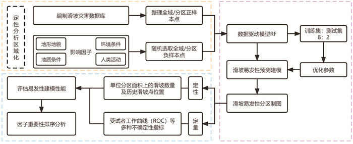
图 3 基于水系分区的滑坡易发性评价流程
Fig. 3. Flowchart of the landslide susceptibility based on hydrographic division
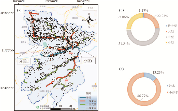
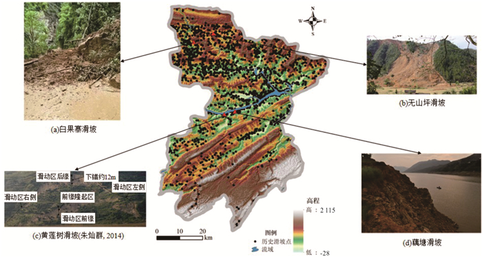
图 4 奉节县分区示意及历史滑坡分类
a.分区示意图;1.长江;2.草堂河;3.梅溪河;4.朱衣河;5.安坪河;6.大溪河;7.崔家河;8.花园河;9.石马河;10.车家坝河;11.甲高河;12.石荀河;13.新民河;14.大洞河;15.羊圈河;16.撒谷溪;17.高治河;18.竹坪溪;19.杨坪沟;20.双岔河;21.清泉河;b.滑坡规模分类;c. 滑坡类型分类
Fig. 4. Zonation map of Fengjie County and classification of historical landslides
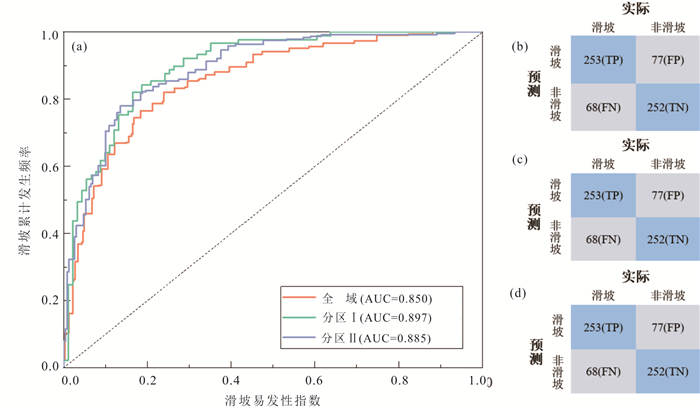
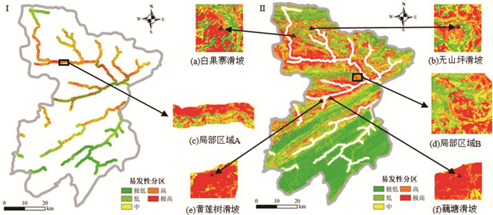
图 8 模型成功率曲线及混淆矩阵
a.ROC曲线;b.全域;c.分区Ⅰ;d.分区Ⅱ
Fig. 8. Validation AUC values and confusion matrixes of different models
表 1 数据来源
Table 1. Data and data sources
数据名称 来源 类型 精度 历史滑坡 重庆市地质环境监测站 数据表 高程 地理空间数据云 栅格 30 m 岩性 全国地质资料馆 矢量 1∶20万 卫星图像 MODIS中国合成产品 栅格 30 m 土地利用类型 GlobeLand30 栅格 30 m 水系 水利局 矢量 1∶10万 道路 交通委 矢量 1∶10万 POI python爬虫 数据表 年平均降雨量 中国气象网 数据表  下载: 导出CSV
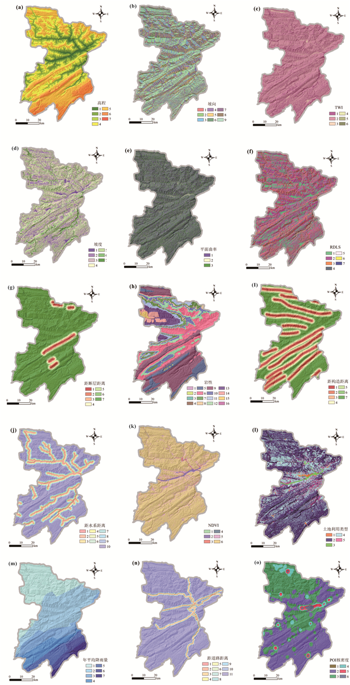
表 2 影响因子重分类标准
Table 2. Reclassification criteria of factors affecting landslides
因子 分级 因子 分级 因子 分级 高程(m) 1. < 250 坡向 1. 平面 8. 西 TWI 1. < 5 2. 250~500 2. 北 9. 西北 2. 5~10 3. 500~750 3. 东北 3. 10~15 4. 750~1 000 4. 东 4. 15~20 5. 1 000~1 500 5. 东南 5. ≥20 6. 1 500~2 000 6. 南 7. ≥2 000 7. 西南 坡度(°) 1. < 6 平面曲率 1. < -0.01 RDLS 1. 0~20 2. 6~12 2. -0.01~0.01 2. 20~40 3. 12~18 3. ≥0.01 3. 40~60 4. 18~24 剖面曲率 1. < -0.01 4. 60~80 5. 24~34 2. -0.01~0.01 5. 80~100 6. 34~44 3. ≥0.01 6. 100~120 7. ≥44 7. ≥120 距断层距离(m) 1. < 500 岩性 1. S1-2 9. T1j 距构造距离(m) 1. < 500 2. 500~1 000 2. P2 10. J1z 2. 500~1 000 3. 1 000~1 500 3. T1-2j 11. J2xs 3. 1 000~1 500 4. 1 500~2 000 4. P1 12. T3xj 4. 1 500~2 000 5. 2 000~2 500 5. T1d 13. J2s 5. 2 000~2 500 6. 2 500~3 000 6. T2b 14. J3s 6. 2 500~3 000 7. ≥3 000 7. J2x 15. J3p 7. ≥3 000 8. J1-2z 16.不明 距水系距离(m) 1. < 200 NDVI 1. < -0.25 年平均降雨量(mm) 2. 200~400 2. ≥-0.25~0 1. < 1 190 3. 400~600 3. ≥0~0.25 2. 1 190~1 235 4. 600~800 4. ≥0.25~0.5 3. 1 235~1 280 5. 800~1 000 5. ≥0.5~0.75 4. 1 280~1 325 6. 1 000~1 200 6. ≥0.75~1.00 5. 1 325~1 370 7. 1 200~1 400 土地利用类型 1. 人造地表 6. 1 370~1 415 8. 1 400~1 600 2. 林地 5. 草地 7. 1 415~1 450 9. 1 600~1 800 3. 水体 10. ≥1 800 4. 耕地 距道路距离(m) 1. < 100 7. 600~700 POI核密度 1. < 2 000 2. 100~200 8. 700~800 2. 2 000~20 000 3. 200~300 9. 800~900 3. 20 000~50 000 4. 300~400 10. 900~1 000 4. 50 000~100 000 5. 400~500 11. ≥1 000 5. 100 000~200 000 6. 500~600 6. ≥200 000
下载: 导出CSV
表 3 易发性分区中滑坡频率信息统计
Table 3. Statistic results of landslide susceptibility in different levels of different models
模型 滑坡易发性分区 滑坡敏感性阈值 滑坡比率(%) 面积比率(%) 频率比(%) 全域 极低易发区 0~0.145 0.56 32.29 0.017 低易发区 0.145~0.345 1.18 25.44 0.047 中易发区 0.345~0.557 4.17 17.97 0.232 高易发区 0.557~0.769 16.82 14.34 1.173 极高易发区 0.769~1.000 77.26 9.96 7.758 分区Ⅰ 极低易发区 0~0.161 0.00 25.26 0.000 低易发区 0.161~0.333 1.52 22. 76 0.067 中易发区 0.333~0.510 2.03 21.37 0.095 高易发区 0.510~0.706 8.88 19.05 0.466 极高易发区 0.706~1.000 87.56 11.56 7.576 分区Ⅱ 极低易发区 0~0.149 0.82 29.99 0.027 低易发区 0.149~0.337 2.39 25.79 0.093 中易发区 0.337~0.545 4.12 19.49 0.212 高易发区 0.545~0.757 14.92 14.21 1.050 极高易发区 0.757~1.000 77.74 10.51 7.394
下载: 导出CSV
表 4 三种模型的表现结果
Table 4. The performance results of the three models
模型 评价指标 AUC 准确率 精确率 召回率 F1分数 全域 0.777 0.767 0.788 0.777 0.850 分区Ⅰ 0.817 0.822 0.813 0.818 0.897 分区Ⅱ 0.813 0.811 0.803 0.807 0.885
下载: 导出CSV
-
Ali, S. K. A., Parvin, F., Pham, Q. B., et al., 2022. An Ensemble Random Forest Tree with SVM, ANN, NBT, and LMT for Landslide Susceptibility Mapping in the Rangit River Watershed, India. Natural Hazards, 113(3): 1601-1633. https://doi.org/10.1007/s11069-022-05360-5 Amiri, M., Pourghasemi, H. R., Ghanbarian, G. A., et al., 2019. Assessment of the Importance of Gully Erosion Effective Factors Using Boruta Algorithm and Its Spatial Modeling and Mapping Using Three Machine Learning Algorithms. Geoderma, 340: 55-69. https://doi. org/10.1016/j. geoderma. 2018.12. 042. doi: 10.1016/j.geoderma.2018.12.042 Bai, S. B., Wang, J., Lu, G. N., et al., 2010. GIS-Based Logistic Regression for Landslide Susceptibility Mapping of the Zhongxian Segment in the Three Gorges Area, China. Geomorphology, 115(1-2): 23-31. https://doi.org/10.1016/j.geomorph.2009.09.025 Basu, T., Pal, S., 2018. Identification of Landslide Susceptibility Zones in Gish River Basin, West Bengal, India. Georisk: Assessment and Management of Risk for Engineered Systems and Geohazards, 12(1): 14-28. https://doi.org/10.1080/17499518.2017.1343482 Breiman, L., 2001. Random Forests. Machine Learning, 45(1): 5-32. https://doi.org/10.1023/a:1010933404324 Chen, T., Zhu, L., Niu, R. Q., et al., 2020. Mapping Landslide Susceptibility at the Three Gorges Reservoir, China, Using Gradient Boosting Decision Tree, Random Forest and Information Value Models. Journal of Mountain Science, 17(3): 670-685. https://doi.org/10.1007/s11629-019-5839-3 Das, A. M., Kumar, N. S., Kanti, M. S., 2011. Landslide Hazard and Risk Analysis in India at a Regional Scale. Disaster Advances, 4(2): 26-39. http://www.researchgate.net/publication/287631967_Landslide_Hazard_and_Risk_Analysis_in_India_at_a_Regional_Scale Guo, Z. Z., Yin, K. L., Huang, F. M., et al., 2019. Evaluation of Landslide Susceptibility Based on Landslide Classification and Weighted Frequency Ratio Model. Chinese Journal of Rock Mechanics and Engineering, 38(2): 287-300 (in Chinese with English abstract). http://en.cnki.com.cn/Article_en/CJFDTotal-YSLX201902007.htm Havenith, H. B., Torgoev, A., Schlogel, R., et al., 2015. Tien Shan Geohazards Database: Landslide Susceptibility Analysis. Geomorphology, 249: 32-43. https://doi.org/10.1016/j.geomorph.2015.03.019 Huang, F. M., Cao, Y., Fan, X. M., et al., 2021. Effects of Different Landslide Boundaries and Their Spatial Shapes on the Uncertainty of Landslide Susceptibility Prediction. Chinese Journal of Rock Mechanics and Engineering, 40(S2): 3227-3240 (in Chinese with English abstract). Huang, F. M., Chen, J. W., Fan, X. M., et al., 2022. Logistic Regression Fitting of Rainfall-Induced Landslide Occurrence Probability and Continuous Landslide Hazard Prediction Modelling. Earth Science, 47(12): 4609-4628 (in Chinese with English abstract). http://www.sciencedirect.com/science/article/pii/S0169555X22001295 Huang, F. M., Wang, Y., Dong, Z. l., et al., 2019. Regional Landslide Susceptibility Mapping Based on Grey Relational Degree Model. Earth Science, 44(2): 664-676 (in Chinese with English abstract). http://en.cnki.com.cn/Article_en/CJFDTotal-DQKX201902027.htm Khamkar, D. J., Mhaske, S. Y., 2019. Identification of Landslide Susceptible Settlements Using Geographical Information System of Yelwandi River Basin, Maharashtra (India). Natural Hazards, 96(3): 1263-1287. https://doi.org/10.1007/s11069-019-03609-0 Li, S. L., Xu, Q., Tang, M. G., et al., 2019. Characterizing the Spatial Distribution and Fundamental Controls of Landslides in the Three Gorges Reservoir Area, China. Bulletin of Engineering Geology and the Environment, 78(6): 4275-4290. https://doi.org/10.1007/s10064-018-1404-5 Li, W. B., Fan, X. M., Huang, F. M., et al., 2021. Uncertainties of Landslide Susceptibility Modeling under Different Environmental Factor Connections and Prediction Models. Earth Science, 46(10): 3777-3795 (in Chinese with English abstract). http://www.sciencedirect.com/science/article/pii/S0341816221001090 Li, Y. W., Wang, X. M., Mao, H., 2020. Influence of Human Activity on Landslide Susceptibility Development in the Three Gorges Area. Natural Hazards, 104(3): 2115-2151. https://doi.org/10.1007/s11069-020-04264-6 Long, J. J., Liu, Y., Li, C. D., et al., 2021. A Novel Model for Regional Susceptibility Mapping of Rainfall Reservoir Induced Landslides in Jurassic Slide-Prone Strata of Western Hubei Province, Three Gorges Reservoir Area. Stochastic Environmental Research and Risk Assessment, 35(7): 1403-1426. https://doi.org/10.1007/s00477-020-01892-z Sajadi, P., Sang, Y. F., Gholamnia, M., et al., 2022. Evaluation of the Landslide Susceptibility and Its Spatial Difference in the Whole Qinghai-Tibetan Plateau Region by Five Learning Algorithms. Geoscience Letters, 9(1): 9. https://doi.org/10.1186/s40562-022-00218-x Shou, K. J., Chen, J. R., 2021. On the Rainfall Induced Deep-Seated and Shallow Landslide Hazard in Taiwan. Engineering Geology, 288. https://doi.org/10.1016/j.enggeo.2021.106156 Sun, D. L., Gu, Q. Y., Wen, H. J., et al., 2022. A Hybrid Landslide Warning Model Coupling Susceptibility Zoning and Precipitation. Forests, 13: 827. https://doi.org/10.3390/f13060827 Sun, D. L., Xu, J. H., Wen, H. J., et al., 2021. Assessment of Landslide Susceptibility Mapping Based on Bayesian Hyperparameter Optimization: A Comparison between Logistic Regression and Random Forest. Engineering Geology, 281. https://doi.org/10.1016/j.enggeo.2020.105972 Van Den Eeckhaut, M., Marre, A., Poesen, J., 2010. Comparison of Two Landslide Susceptibility Assessments in the Champagne-Ardenne Region (France). Geomorphology, 115(1-2): 141-55. https://doi.org/10.1016/j.geomorph.2009.09.042 Wang, J. G., Schweizer, D., Liu, Q. B., et al., 2021a. Three-Dimensional Landslide Evolution Model at the Yangtze River. Engineering Geology, 292. https://doi.org/10.1016/j.enggeo.2021.106275 Wang, L. Q., Zhang, Z. H., Huang, B. L., et al., 2021b. Triggering Mechanism and Possible Evolution Process of the Ancient Qingshi Landslide in the Three Gorges Reservoir. Geomatics, Natural Hazards and Risk, 12(1): 3160-3174. https://doi.org/10.1080/19475705.2021.1998230 Wang, M., Qiao, J. P., 2013. Reservoir-Landslide Hazard Assessment Based on Gis: A Case Study in Wanzhou Section of the Three Gorges Reservoir. Journal of Mountain Science, 10(6): 1085-1096. https://doi.org/10.1007/s11629-013-2498-7 Weidner, L., DePrekel, K., Oommen, T., et al., 2019. Investigating Large Landslides along a River Valley Using Combined Physical, Statistical, and Hydrologic Modeling. Engineering Geology, 259. https://doi.org/10.1016/j.enggeo.2019.105169 Wu, R. Z., Hu, X. D., Mei, H. B., et al., 2021. Spatial Susceptibility Assessment of Landslides Based on Random Forest: A Case Study from Hubei Section in the Three Gorges Reservoir Area. Earth Science, 46(1): 321-330 (in Chinese with English abstract). Xiao, T., 2020. Landslide Risk Assessment in Wanzhou District and a Key Section, Three Gorges Reservoir (Dissertation). China University of Geosciences, Wuhan (in Chinese with English abstract). Xu, X. J., Yang, Q., 2014. Study of Reservoir-Accumulative Landslide's Stability Evolution Trend in the Three Gorges Reservoir. Paper Presented at the 5th International Conference on Intelligent Systems Design and Engineering Applications (ISDEA), Zhangjiajie. Yang, B. B., Yin, K. L., Lacasse, S., et al., 2019. Time Series Analysis and Long Short-Term Memory Neural Network to Predict Landslide Displacement. Landslides, 16(4): 677-694. https://doi.org/10.1007/s10346-018-01127-x Ye, R. Q., Li, S. Y., Guo, F., et al., 2021. RS and GIS Analysis on Relationship between Landslide Susceptibility and Land Use Change in Three Gorges Reservoir Area. Journal of Engineering Geology, 29(3): 724-733 (in Chinese with English abstract). Yin, Y. P., Wang, L. Q., Zhao, P., et al., 2022. Crashed Failure Mechanism & Prevention of Fractured High-Steep Slope in the Three Gorges Reservoir, China. Journal of Hydraulic Engineering, 53(4): 379-391 (in Chinese with English abstract). Yu, X. Y., Wang, Y., Niu, R. Q., et al., 2016. A Combination of Geographically Weighted Regression, Particle Swarm Optimization and Support Vector Machine for Landslide Susceptibility Mapping: A Case Study at Wanzhou in the Three Gorges Area, China. International Journal of Environmental Research and Public Health, 13(5): 487. https://doi.org/10.3390/ijerph13050487 Zhang, H. J., Song, Y. X., Xu, S. L., et al., 2022. Combining a Class-Weighted Algorithm and Machine Learning Models in Landslide Susceptibility Mapping: A Case Study of Wanzhou Section of the Three Gorges Reservoir, China. Computers & Geosciences, 158. https://doi.org/10.1016/j.cageo.2021.104966. Zhang, K. Q., Wang, L. Q., Zhang, W. G., et al., 2021. Formation and Failure Mechanism of the Xinfangzi Landslide in Chongqing City (China). Applied Sciences- Basel, 11(19). https://doi.org/10.3390/app11198963 Zhou, C., Yin, K. L., Cao, Y., et al., 2018. Landslide Susceptibility Modeling Applying Machine Learning Methods: A Case Study from Longju in the Three Gorges Reservoir Area, China. Computers & Geosciences, 112: 23-37. https://doi.org/10.1016/j.cageo.2017.11.019 Zhou, X. T., Huang, F. M., Wu, W. C., et al., 2022. Regional Landslide Susceptibility Prediction Based on Negative Sample Selected by Coupling Information Value Method. Advanced Engineering Sciences, 54(3): 25-35 (in Chinese with English abstract). Zhou, X. Z., Wen, H. J., Li, Z. W., et al., 2022. An Interpretable Model for the Susceptibility of Rainfall-Induced Shallow Landslides Based on SHAP and XGBoost. Geocarto International, 37(26): 13419-13450. https://doi.org/10.1080/10106049.2022.2076928 Zhu, C. Q., 2014. Landslide Stability and Contol Analysis of Huanglianshu in Fengjie County (Dissertation). Chongqing University, Chongqing (in Chinese with English abstract). 郭子正, 殷坤龙, 黄发明, 等, 2019. 基于滑坡分类和加权频率比模型的滑坡易发性评价. 岩石力学与工程学报, 38(2): 287-300. https://www.cnki.com.cn/Article/CJFDTOTAL-YSLX201902007.htm 黄发明, 曹昱, 范宣梅, 等, 2021. 不同滑坡边界及其空间形状对滑坡易发性预测不确定性的影响规律. 岩石力学与工程学报, 40(S2): 3227-3240. https://www.cnki.com.cn/Article/CJFDTOTAL-YSLX2021S2023.htm 黄发明, 陈佳武, 范宣梅, 等, 2022. 降雨型滑坡时间概率的逻辑回归拟合及连续概率滑坡危险性建模. 地球科学, 47(12): 4609-4628. doi: 10.3799/dqkx.2021.164 黄发明, 汪洋, 董志良, 等, 2019. 基于灰色关联度模型的区域滑坡敏感性评价. 地球科学, 44(2): 664-676. doi: 10.3799/dqkx.2018.175 李文彬, 范宣梅, 黄发明, 等, 2021. 不同环境因子联接和预测模型的滑坡易发性建模不确定性. 地球科学, 46(10): 3777-3795. doi: 10.3799/dqkx.2021.042 吴润泽, 胡旭东, 梅红波, 等, 2021. 基于随机森林的滑坡空间易发性评价: 以三峡库区湖北段为例. 地球科学, 46(1): 321-330. doi: 10.3799/dqkx.2020.032 肖婷, 2020. 三峡库区万州区及重点库岸段滑坡灾害风险评价(博士学位论文). 武汉: 中国地质大学. 叶润青, 李士垚, 郭飞, 等, 2021. 基于RS和GIS的三峡库区滑坡易发程度与土地利用变化的关系研究. 工程地质学报, 29(3): 724-733. https://www.cnki.com.cn/Article/CJFDTOTAL-GCDZ202103015.htm 殷跃平, 王鲁琦, 赵鹏, 等, 2022. 三峡库区高陡岸坡溃屈失稳机理及防治研究. 水利学报, 53(4): 379-391. https://www.cnki.com.cn/Article/CJFDTOTAL-SLXB202204001.htm 周晓亭, 黄发明, 吴伟成, 等, 2022. 基于耦合信息量法选择负样本的区域滑坡易发性预测. 工程科学与技术, 54(3): 25-35. https://www.cnki.com.cn/Article/CJFDTOTAL-SCLH202203003.htm 朱灿群, 2014. 奉节县黄莲树滑坡稳定性及治理分析(硕士学位论文). 重庆: 重庆大学. -


 点击查看大图
计量
- 文章访问数: 1335
- HTML全文浏览量: 629
- PDF下载量: 106
- 被引次数: 0
