


Landslide Hazard Assessment in Northeast Afghanistan Plateau Based on Optimized Neural Network
-
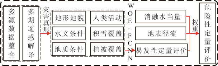
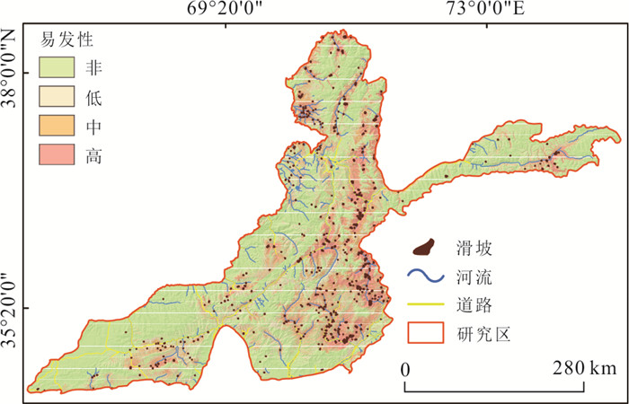
摘要: 阿富汗东北部是典型的高原寒旱地区,滑坡灾害发育,除受地形地貌、地质构造、人类活动等因素影响外,还由积雪覆盖、冰雪消融等方面控制;为研究高原寒旱地区滑坡危险性,在遥感解译基础数据上,考虑高原寒旱地区积雪覆盖和冰川活动对滑坡发育的影响,引入积雪覆盖度和消融水当量两个评价指标,基于证据权‒全连接神经网络模型建立滑坡易发性评价模型,以度日模型、SCS-CN模型建立滑坡危险性评价体系,并根据混淆矩阵对评价模型进行检验;危险性评价结果表明极高危险性区域占全区10.46%,分布灾害面积占比82.71%,主要分布在努尔斯坦省东部库纳尔‒奇特拉尔河段、巴达赫尚省除瓦罕走廊段的中东部高山区和帕尔万省赫尔曼德河段;高危险性区域占全区14.83%,分布灾害面积占比12.11%,主要分布在巴达赫尚省东部区域、努尔斯坦省和帕尔万省西部.检验结果及统计结果均表明结合证据权法取负样本对神经网络精度提升显著;研究成果为阿富汗滑坡灾害早期预警与工程防治提供科学依据.Abstract: The northeastern part of Afghanistan is a typical cold and arid region where landslide geological hazards are developed. The landslide development is not only affected by topography, geological structure, human activities, and other factors, but also is controlled by snow cover, snow, and ice melt. In this paper, based on the primary data of remote sensing interpretation, considering the influence of snow cover and glacier activity on landslide development, two evaluation indexes of snow cover and ablation water equivalent were introduced to study the landslide risk in the cold and dry areas of the plateau. The landslide susceptibility evaluation system was established based on the weight of evidence and a fully connected neural network model. Degree-day model and SCS-CN model established the landslide risk evaluation system, and the evaluation model was tested according to the confusion matrix. The hazard assessment results show that the extremely high-risk area accounts for 10.46% of the total area, and the disaster area accounts for 82.71%, mainly distributed in the Kunar-Chitral reach in the east of Nuristan Province, the middle and eastern high mountains of Badakhshan Province except for Wakhan corridor section, and the Helmand Reach in Parwan Province. The high-risk area accounts for 14.83% of the total area, and the disaster area accounts for 12.11%, mainly distributed in the eastern region of Badakhshan Province, the western region of Nuristan Province, and Parwan Province. The test results and statistical results all show that the accuracy of the neural network is significantly improved by taking negative samples with a weight of evidence method. The research results can provide the scientific basis for Afghanistan's early warning and prevention of landslide geological disasters.
-
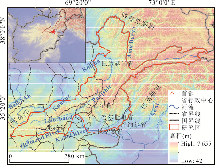
图 1 阿富汗东北部高原区地理位置
Fig. 1. Geographical location of the plateau region in northeast Afghanistan
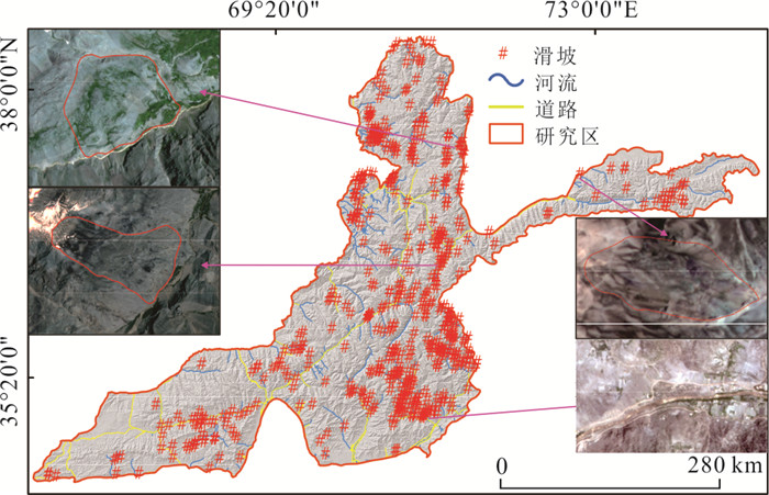
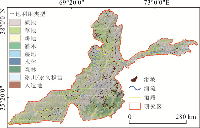
图 2 研究区滑坡及道路河流遥感解译图
Fig. 2. Remote sensing interpretation map of landslide, road and river
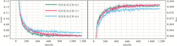
图 6 不同比例训练集、验证集数据成果
Fig. 6. Data results of training set and validation set in different proportions
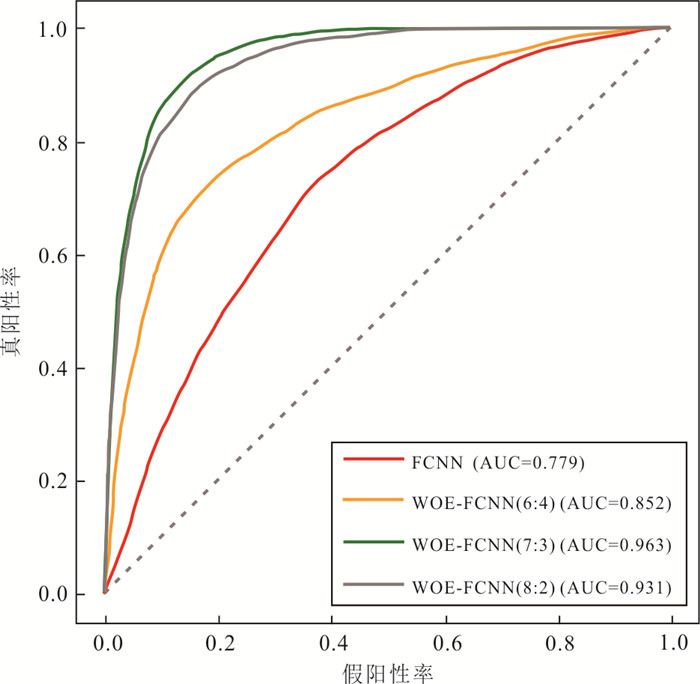
图 7 不同比例训练集验证集评价结果
Fig. 7. Different proportions of training sets verify the evaluation results of training sets
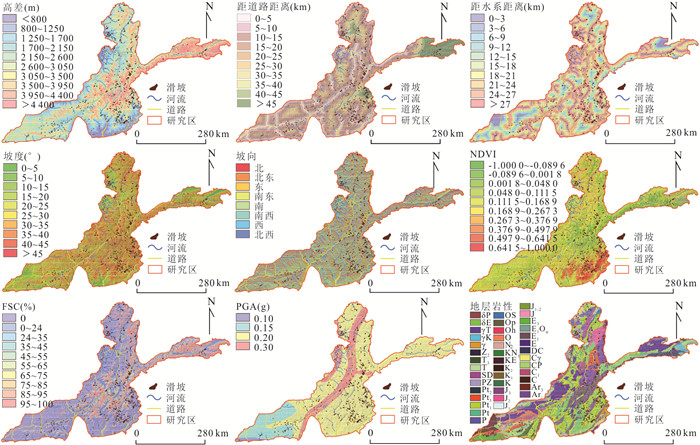
表 1 研究区基础数据来源
Table 1. Basic data sources
分类 数据源 分辨率(m) 底图 Google Earth Engine / DEM ASTER GDEM V3 30 遥感影像 Planet 3 水系 道路 地质构造 文献资料 / 地震 地层岩性 1:500万亚洲构造图 / 降雨 美国国家航空航天局 600 温度 积雪覆盖度 Science Data Bank 600 植被覆盖度(NDVI) Landsat8 30  下载: 导出CSV
表 2 不同土地利用下的CN值
Table 2. CN values under different land uses
土壤湿度 干燥 适中 湿润 裸地 69 70 84 灌木 72 81 86 草地 51 63 70 森林 60 73 79 冰川 80 88 95 耕地 71 78 81 人造地表 74 82 86 湿地 40 60 78 水体 100 100 100
下载: 导出CSV
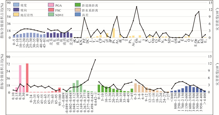
表 3 研究区滑坡易发性评价指标相关性系数
Table 3. Correlation coefficients of landslide susceptibility evaluation index
因子 X1 X2 X3 X4 X5 X6 X7 X8 X9 X10 X11 X12 X13 X14 X1 1 X2 0.112 1 X3 0.148 0.038 1 X4 0.014 ‒0.08 ‒0.38 1 X5 ‒0.66 ‒0.25 ‒0.34 ‒0.03 1 X6 ‒0.34 ‒0.33 0.104 0.256 ‒0.52 1 X7 ‒0.17 ‒0.21 0.276 0.625 ‒0.06 0.323 1 X8 0.124 0.107 0.128 0.031 0.013 ‒0.01 ‒0.12 1 X9 ‒0.12 0.05 ‒0.29 ‒0.08 ‒0.04 ‒0.1 0.076 ‒0.15 1 X10 0.213 0.193 0.346 ‒0.01 0.41 ‒0.01 0.036 0.021 0.009 1 X11 0.186 0.139 0.141 ‒0.22 ‒0.03 ‒0.05 ‒0.05 ‒0.15 ‒0.08 0.236 1 X12 ‒0.21 ‒0.25 ‒0.02 ‒0.11 0.049 ‒0.33 ‒0.03 0.024 ‒0.01 ‒0.26 0.084 1 X13 ‒0.15 0.019 ‒0.01 ‒0.01 ‒0.09 0.07 0.306 0.021 ‒0.03 ‒0.13 ‒0.02 0.219 1 X14 ‒0.02 0.001 0.001 ‒0.14 0.001 0.002 0.541 0.005 0.001 0.003 0.008 ‒0.01 0.002 1
下载: 导出CSV
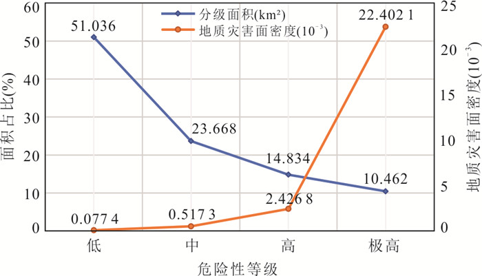
表 4 研究区滑坡易发性评价统计
Table 4. Susceptibility statistics of landslide
分级 分级面积(km²) 分级占比(%) 灾害面积(km²) 灾害占比(%) 灾害密度 非 52 439 54.46 1.41 0.49 0.027×10‒3 低 19 744 20.51 8.58 2.97 0.434×10‒3 中 13 252 13.76 30.74 10.63 2.319×10‒3 高 10 846 11.27 248.2 85.91 22.89×10‒3
下载: 导出CSV
表 5 研究区危险性权重判别矩阵
Table 5. Discriminant matrix of hazard weight
因子名称 易发性 消融水当量 地表径流 权重 易发性 1 4 5 0.665 消融水当量 1/4 1 4 0.245 地表径流 1/5 1/4 1 0.090
下载: 导出CSV
-
Caniani, D., Pascale, S., Sdao, F., et al., 2008. Neural Networks and Landslide Susceptibility: A Case Study of the Urban Area of Potenza. Natural Hazards, 45(1): 55-72. https://doi.org/10.1007/s11069⁃007⁃9169⁃3 Chang, M., Cui, P., Dou, X. Y., et al., 2021. Quantitative Risk Assessment of Landslides over the China⁃Pakistan Economic Corridor. International Journal of Disaster Risk Reduction, 63: 102441. https://doi.org/10.1016/j.ijdrr.2021.102441 Fu, S. H., Wang, X. L., Wang, H. Y., et al., 2012. Meathod of Determining CN Value in the SCS⁃CN Method. Arid Land Geography, 35(3): 415-421 (in Chinese with English abstract). http://en.cnki.com.cn/Article_en/CJFDTOTAL-GHDL201203013.htm Gent, C. R., Sheppard, C. P., 1992. Special Feature. Predicting Time Series by a Fully Connected Neural Network Trained by Back Propagation. Control & Automation, 3(3): 109-112. Guo, Z. Z., Yin, K. L., Fu, S., et al., 2019. Evaluation of Landslide Susceptibility Based on GIS and WOE⁃BP Model. Earth Science, 44(12): 4299-4312 (in Chinese with English abstract). http://www.researchgate.net/publication/324390254_Evaluation_of_Landslide_Susceptibility_Based_on_GIS_and_WOE-BP_Model Huang, R. Q., Xiang, X. Q., Ju, N. P., 2004. Assessment of China's Regional Geohazards: Present Situation and Problems. Geological Bulletin of China, 23(11): 1078-1082 (in Chinese with English abstract). doi: 10.3969/j.issn.1671-2552.2004.11.005 Huang, W. B., Ding, M. T., Wang, D., et al., 2022. Evaluation of Landslide Susceptibility Based on Layer Adaptive Weighted Convolutional Neural Network Model along Sichuan⁃Tibet Traffic Corridor. Earth Science, 47(6): 2015-2030 (in Chinese with English abstract). Huang, Y. D., Xu, C., Zhang, X. L., et al., 2021. An Updated Database and Spatial Distribution of Landslides Triggered by the Milin, Tibet Mw6.4 Earthquake of 18 November 2017. Journal of Earth Science, 32(5): 1069-1078. https://doi.org/10.1007/s12583⁃021⁃1433⁃z Le, J., Qu, C. H., Li, H. S., 2019. Status Quo of Agricultural Development in Afghanistan and China⁃Afghanistan Agricultural Cooperation Strategy. Agricultural Outlook, 15(5): 113-117 (in Chinese with English abstract). doi: 10.3969/j.issn.1673-3908.2019.05.023 Li, B. Y., Pan, B. T., 2002. Progress in Paleogeographic Study of the Tibetan Plateau. Geographical Research, 21(1): 61-70 (in Chinese with English abstract). doi: 10.3321/j.issn:1000-0585.2002.01.008 Liu, J., Wu, Z., 2020. Landslide Risk Assessment of the Zhouqu⁃Wudu Section of Bailong River Basin Based on Geographic Information System. China Earthquake Engineering Journal, 42(6): 1723-1734 (in Chinese with English abstract). Liu, J. P., Zhang, W. C., 2018. Spatial Variability in Degree⁃Day Factors in Yarlung Zangbo River Basin in China. Journal of University of Chinese Academy of Sciences, 35(5): 704-711 (in Chinese with English abstract). http://www.researchgate.net/publication/337338025_Spatial_variability_in_degree-day_factors_in_Yarlung_Zangbo_River_Basin_in_China/download Liu, W. C., Zhang, Y., Liang, Y. W., et al., 2022. Landslide Risk Assessment Using a Combined Approach Based on InSAR and Random Forest. Remote Sensing, 14(9): 2131. https://doi.org/10.3390/rs14092131 Liu, Y., Tang, C., Feng, Y., 2013. Geological Disaster Risk Assessment Based on AHP Information Method. Earth and Environment, 41(2): 173-179 (in Chinese with English abstract). http://en.cnki.com.cn/Article_en/CJFDTOTAL-DZDQ201302014.htm Maher, I. S., Biswajeet, P., Saro, L., 2020. Application of Convolutional Neural Networks Featuring Bayesian Optimization for Landslide Susceptibility Assessment. Catena, 186(C): 104249. https://doi.org/10.1016/j.catena.2019.104249 Nandi, A., Shakoor, A., 2008. Application of Logistic Regression Model for Slope Instability Prediction in Cuyahoga River Watershed, Ohio, USA. Georisk: Assessment and Management of Risk for Engineered Systems and Geohazards, 2(1): 16-27. https://doi.org/10.1080/17499510701842221 Pellicani, R., Argentiero, I., Spilotro, G., 2017. GIS⁃Based Predictive Models for Regional⁃Scale Landslide Susceptibility Assessment and Risk Mapping along Road Corridors. Geomatics, Natural Hazards and Risk, 8(2): 1012-1033. https://doi.org/10.1080/19475705.2017.1292411 Pellicciotti, F., Brock, B., Strasser, U., et al., 2005. An Enhanced Temperature⁃Index Glacier Melt Model Including the Shortwave Radiation Balance: Development and Testing for Haut Glacier d'Arolla, Switzerland. Journal of Glaciology, 51(175): 573-587. https://doi.org/10.3189/172756505781829124 Petpongpan, C. C., Ekkawatpanit, C., Kositgittiwong, D., 2021. Landslide Risk Assessment Using Hydrological Model in the Upper Yom River Basin, Thailand. Catena, 204: 105402. https://doi.org/10.1016/j.catena.2021.105402 Psomiadis, E., Soulis, K. X., Efthimiou, N., 2020. Using SCS⁃CN and Earth Observation for the Comparative Assessment of the Hydrological Effect of Gradual and Abrupt Spatiotemporal Land Cover Changes. Water, 12(5): 1386. https://doi.org/10.3390/w12051386 Regine, H., 2005. Glacier Melt: A Review of Processes and Their Modelling. Progress in Physical Geography, 29(3): 362-391. https://doi.org/10.1191/0309133305pp453ra Tang, C., Qi, X., Ding, J., et al., 2010. Dynamic Analysis on Rainfall⁃Induced Landslide Activity in High Seismic Intensity Areas of the Wenchuan Earthquake Using Remote Sensing Image. Earth Science, 35(2): 317-323 (in Chinese with English abstract). Tang, C., Zhu, J., Zhang, X. R., 2001. GIS Based Earthquake Triggered Landslide Hazard Prediction. Journal of Seismoloical Research, 24(1): 73-81(in Chinese with English abstract). http://en.cnki.com.cn/Article_en/CJFDTOTAL-DZYJ200101011.htm Wang, D., Hao, M. M., Chen, S., et al., 2021. Assessment of Landslide Susceptibility and Risk Factors in China. Natural Hazards, 108(3): 3045-3059. https://doi.org/10.1007/s11069⁃021⁃04812⁃8 Wang, Y. Y., 2015. Recent Disasters around the World. Overview of Disaster Prevention, (2): 90-95 (in Chinese). Wu, L. S., 2016. Geological Structure and Mineral Resources in Afghanistan (1). Mineral Deposits, 35(1): 203-208 (in Chinese). Wu, R. Z., Hu, X. D., Mei, H. B., et al., 2021. Spatial Susceptibility Assessment of Landslides Based on Random Forest: A Case Study from Hubei Section in the Three Gorges Reservoir Area. Earth Science, 46(1): 321-330 (in Chinese with English abstract). Xiang, X. Q., Huang, R. Q., 2000. Application of GIS⁃Based Artificial Neural Networks on Assessment of Geohazards Risk. The Chinese Journal of Geological Hazard and Control, 11(3): 23-27 (in Chinese with English abstract). http://search.cnki.net/down/default.aspx?filename=ZGDH200003005&dbcode=CJFD&year=2000&dflag=pdfdown Xu, Q., Huang, R. Q., Xiang, X. Q., 2000. Time and Spacial Predicting of Geological Hazards Occurrence. Journal of Mountain Science, 18(S1): 112-117 (in Chinese with English abstract). http://en.cnki.com.cn/Article_en/CJFDTOTAL-SDYA2000S1024.htm Yu, H., Lu, Z., 2018. Review on Landslide Susceptibility Mapping Using Support Vector Machines. Catena, 165: 520-529. https://doi.org/10.1016/j.catena.2018.03.003 Zhang, J., Yin, K. L., Wang, J. J., et al., 2016. Evaluation of Landslide Susceptibility for Wanzhou District of Three Gorges Reservoir. Chinese Journal of Rock Mechanics and Engineering, 35(2): 284-296 (in Chinese with English abstract). http://en.cnki.com.cn/Article_en/CJFDTOTAL-YSLX201602010.htm Zhou, C., Chang, M., Xu, L., et al., 2020. Risk Assessment of Typical Urban Mine Geological Disasters in Guizhou Province. Geomatics and Information Science of Wuhan University, 45(11): 1782-1791 (in Chinese with English abstract). 符素华, 王向亮, 王红叶, 等, 2012. SCS⁃CN径流模型中CN值确定方法研究. 干旱区地理, 35(3): 415-421. https://www.cnki.com.cn/Article/CJFDTOTAL-GHDL201203013.htm 郭子正, 殷坤龙, 付圣, 等, 2019. 基于GIS与WOE⁃BP模型的滑坡易发性评价. 地球科学, 44(12): 4299-4312. doi: 10.3799/dqkx.2018.555 黄润秋, 向喜琼, 巨能攀, 2004. 我国区域地质灾害评价的现状及问题. 地质通报, 23(11): 1078-1082. https://www.cnki.com.cn/Article/CJFDTOTAL-ZQYD200411004.htm 黄武彪, 丁明涛, 王栋, 等, 2022. 基于层数自适应加权卷积神经网络的川藏交通廊道沿线滑坡易发性评价. 地球科学, 47(6): 2015-2030. doi: 10.3799/dqkx.2021.243 乐姣, 曲春红, 李辉尚, 2019. 阿富汗农业发展现状及中阿农业合作策略. 农业展望, 15(5): 113-117. https://www.cnki.com.cn/Article/CJFDTOTAL-NYZW201905024.htm 李炳元, 潘保田, 2002. 青藏高原古地理环境研究. 地理研究, 21(1): 61-70. https://www.cnki.com.cn/Article/CJFDTOTAL-DLYJ200201007.htm 刘杰, 武震, 2020. 基于GIS的白龙江流域舟曲‒武都段的滑坡危险性评价. 地震工程学报, 42(6): 1723-1734. https://www.cnki.com.cn/Article/CJFDTOTAL-ZBDZ202006049.htm 刘金平, 张万昌, 2018. 雅鲁藏布江流域度日因子空间变化(英文). 中国科学院大学学报, 35(5): 704-711. https://www.cnki.com.cn/Article/CJFDTOTAL-ZKYB201805018.htm 刘洋, 唐川, 冯毅, 2013. 基于AHP⁃信息量法的地质灾害危险性评价. 地球与环境, 41(2): 173-179. https://www.cnki.com.cn/Article/CJFDTOTAL-DZDQ201302014.htm 唐川, 齐信, 丁军, 等, 2010. 汶川地震高烈度区暴雨滑坡活动的遥感动态分析. 地球科学, 35(2): 317-323. doi: 10.3799/dqkx.2010.033 唐川, 朱静, 张翔瑞, 2001. GIS支持下的地震诱发滑坡危险区预测研究. 地震研究, 24(1): 73-81. https://www.cnki.com.cn/Article/CJFDTOTAL-DZYJ200101011.htm 王一媛, 2015. 全球近期灾害录. 防灾博览, (2): 90-95. https://www.cnki.com.cn/Article/CJFDTOTAL-FZBL202106015.htm 吴良士, 2016. 阿富汗地质构造及其矿产资源(一). 矿床地质, 35(1): 203-208. https://www.cnki.com.cn/Article/CJFDTOTAL-KCDZ201604016.htm 吴润泽, 胡旭东, 梅红波, 等, 2021. 基于随机森林的滑坡空间易发性评价: 以三峡库区湖北段为例. 地球科学, 46(1): 321-330. doi: 10.3799/dqkx.2020.032 向喜琼, 黄润秋, 2000. 基于GIS的人工神经网络模型在地质灾害危险性区划中的应用. 中国地质灾害与防治学报, 11(3): 23-27. https://www.cnki.com.cn/Article/CJFDTOTAL-ZGDH200003005.htm 许强, 黄润秋, 向喜琼, 2000. 地质灾害发生时间和空间的预测预报. 山地学报, 18(S1): 112-117. https://www.cnki.com.cn/Article/CJFDTOTAL-SDYA2000S1024.htm 张俊, 殷坤龙, 王佳佳, 等, 2016. 三峡库区万州区滑坡灾害易发性评价研究. 岩石力学与工程学报, 35(2): 284-296. https://www.cnki.com.cn/Article/CJFDTOTAL-YSLX201602010.htm 周超, 常鸣, 徐璐, 等, 2020. 贵州省典型城镇矿山地质灾害风险评价. 武汉大学学报(信息科学版), 45(11): 1782-1791. https://www.cnki.com.cn/Article/CJFDTOTAL-WHCH202011015.htm -


 点击查看大图
计量
- 文章访问数: 789
- HTML全文浏览量: 745
- PDF下载量: 60
- 被引次数: 0
