


Channel Morphological Evolution in Confluence Area of Hotan River in Tarim Basin
-
摘要: 河流汇流区因展宽深切作用,沉积的砂体规模较大,具有良好的油气储层潜力.我国中新生代的含油气盆地以内陆湖盆为主,其河流体系为主要储层类型.旱区面积占全球陆地面积的41%,河流体系广泛发育,蕴含丰富的资源.然而,当前河流汇流的研究主要集中在潮湿区,旱区河流汇流的平面形态演变及主控因素的研究鲜有报道.选取塔里木盆地和田河汇流区为研究对象,首先利用数字高程数据和高分辨率Google Earth影像来识别满岸河道边界;结合水文资料和时间序列遥感影像,分析了汇流区的河流平面形态演变.结果表明,和田河汇流属于固定型且近“Y”型汇流,支流呈现不同的河型,喀拉喀什河为曲流河,玉龙喀什河为曲流化辫状河,支流均存在着截弯取直现象;汇流后河流类型转化为辫状河,且满岸河道扩宽了505 m,扩宽幅度高达57.8%.在此基础上,选取全球10个典型的半干旱‒干旱区域以及13个潮湿区域的河流汇流实例,对比分析旱区与潮湿区的河流汇流上游支流和汇流河道满岸河宽变化差异.研究表明,少(或无)植被的旱区汇流后的汇流河道扩宽增幅均大于50%,远超过植被发育的潮湿区的汇流河道扩宽增幅(17%).此外,河道坡降显示上述旱区河道(缺少河岸植被)的坡降(2‰)比潮湿区的坡降(0.6‰)大一个数量级.因此,缺少沿河岸植被和地形坡降大是旱区河流汇流展宽幅度较大的主要原因.本研究不仅丰富了现有的河流汇流演变模式,而且为深入开展旱区河流汇流的沉积过程和构建精确的沉积模型提供了参考.Abstract: River confluence has a great potential of hydrocarbon reservoirs owing to wide and thick channel-fill deposits by widening and deepening effects. The Mesozoic and Cenozoic hydrocarbon-bearing basins in China are internally drainage basins dominated and fluvial deposits are widely regarded as important hydrocarbon. The (semi-) arid regions cover 41% of the global continental areas, and river systems are widely distributed with substantial ecological resources. However, current research on river confluence is mainly focused on humid regions, and research on the channel morphology of river confluence in drylands and their controls has been rarely reported. In this study, we select the confluence (Kalakashen River and Yulongkashen River) of the Hotan River in Tarim Basin as study area. Firstly, the combination of Digital Elevation Model (DEM) and high-resolution Google Earth images were used to identify the bankfull boundaries of all river channels. Subsequently the evolution of river planform in the confluence area was analyzed using hydrological data and time-series remote sensing images. Results show that the confluence of Hotan River is a fixed and "Y" type confluence, and their junctions have different river types: Kalakashen River is meandering while Yulongkashen River is meandering-braided transitional. Cutoffs occurred along these junctions. The confluence is transformed into braided river, and its bankfull width increases by 58% (505 m wider) compared with that of junctions. Furthermore, we select 23 river confluences in typical semi-arid-arid regions (n= 10) and humid regions (n=13) around the world to investigate the changes in bankfull width from junctions to confluences. Results reveal that the increase (> 50%) in bankfull widths of river confluence in drylands with (non-) sparse vegetation greatly exceeded that (17%) of river confluence in humid areas with riparian vegetation. Slopes (2‰) of these selected dryland rivers (lack of riparian vegetation) are on average one category higher than those (0.6‰) in humid regions. Therefore, lack of riparian vegetation and high slope of river profiles are the main controls for significant widening in river confluences of dryland regions. Our results not only complement the models of river confluence, but also provide a basis for the further research of sedimentary processes and their sedimentary model in dryland river confluence.
-
Key words:
- Hotan River /
- channel confluence /
- river type evolution /
- bankfull width /
- sedimentology
-
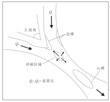
图 1 汇流形态特征示意(据Dixon et al., 2018改)
Fig. 1. Schematic diagram of river confluence (modified from Dixon et al.2018)

图 2 和田河流域及研究区位置示意图(据余其鹰等, 2021)
Fig. 2. Location of Hotan River in Tarim basin and study area (modified from Yu et al., 2021)
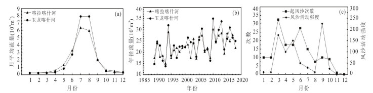
图 3 和田河流域的水文特征
据李志忠等(2004)修改. a.年内月平均径流量变化趋势;b.年径流量变化趋势;c.年内风沙活动变化规律
Fig. 3. Hydrological characteristics of the catchment area of Hotan River
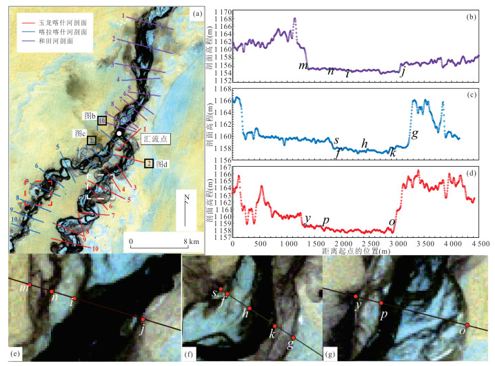

图 5 高分辨率Google Earth卫星图像(a)和星载DEMs数据(b~e)的地形特征对比
图a中箭头方向为水流方向;图b~e中颜色深指示低洼区域
Fig. 5. Comparison of geomorphic features using high-resolution Google Earth imagery (a) and spaceborne DEMs (b‒e)
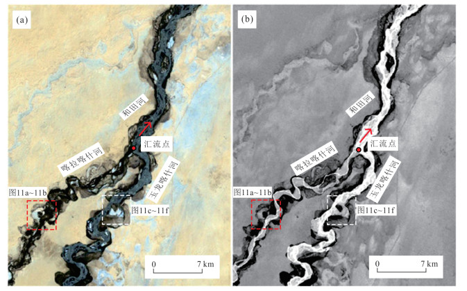
图 7 和田河汇流区水体提取前后对比
a.水体提取前;b.水体提取后.影像来自Landsat 7 ETM+,2011年8月4日;红色箭头为水流方向
Fig. 7. Comparison of water bodies along Hotan River before and after extraction

图 8 研究区满岸河宽、河流曲率及汊道数指数的示意图
a.满岸河宽;b.弯道曲率;c.河流汊道数指数(据李志威等,2018)
Fig. 8. Schematic diagram of river bankfull width and sinuosity and the index of branch number in the study area
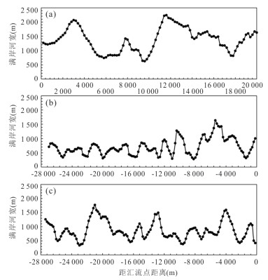
图 9 汇流区的河道满岸河宽沿程变化趋势
横坐标起始点(0)位置为汇流点(见图 7),负值为距汇流点向上游的距离,正值为距汇流点向下游的距离.a.和田河;b.喀拉喀什河;c.玉龙喀什河
Fig. 9. Variations of river width along three rivers in the confluence area
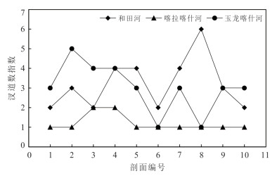
图 10 和田河及其源流的汊道数指数变化趋势
Fig. 10. Variation trend of the index of branch number along Hotan River and its junctions

图 11 喀拉喀什河与玉龙喀什河段内的截弯取直现象
a~b.喀拉喀什河段的截弯取直;c~f.玉龙喀什河段的截弯取直;位置见图 11
Fig. 11. Cutoffs along the Kalakashen and Yulongkashen River
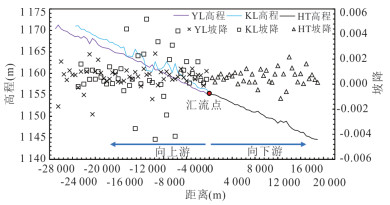
图 12 和田河汇流区的高程变化趋势
YL.玉龙喀什河;KL.喀拉喀什河;HT.和田河;横坐标0点位置为汇流点(见图 7)
Fig. 12. The along-river elevation changes and their slopes in the confluence area of the Hotan River
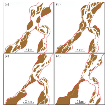
图 13 汇流区中不同年份的河流简化图
a. 1994年8月13日;b. 1997年8月5日;c. 2008年8月5日;d. 2016年7月24日. 红线指河岸线;棕色区域为沙洲
Fig. 13. Simplified maps of rivers in the confluence area for different years
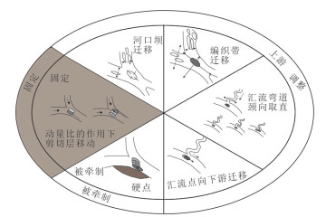
图 14 基于时间尺度的汇流类型分类(据Dixon et al., 2018)
Fig. 14. Types of river confluence based on time scale (modified from Dixon et al., 2018)

图 15 1990‒2020年期间和田河汇流区形态变化
a为1990年8月2日,b为1995年11月4日,均为Landsat 5假彩色影像;c为2000年8月5日,d为2010年10月4日,均为Landsat 7假彩色影像;e为2015年8月23日,f为2020年9月21日,均为Landsat 8假彩色影像
Fig. 15. Morphological changes in the confluence area of the Hotan River during 1990‒2020
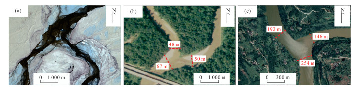
图 16 旱区与潮湿区的河流汇流满岸河宽变化对比
a.和田河汇流,处于旱区;b.美国的Amite-Comite河汇流,c.通江汇流,b和c均处于潮湿区.水流方向:a为由南向北,b和c为由北向南
Fig. 16. Comparison of variations in river width near the river confluence in arid and humid regions
表 1 和田河流域第四纪沉积物的粒度特征
Table 1. Particle-size characteristics of Quaternary sediments in the Hotan River catchment
样品 粒径(mm) 上游河床 中游河床 丘间地 流沙 亚沙土 中游河床 阶地粉沙 下游河床 风成细沙 极粗沙 2~1 2.63 - - - - - - - - 粗沙 1~0.5 8.90 - 0.33 0.83 - 0.23 - - - 中沙 0.5~0.25 33.90 2.17 25.04 7.26 - 27.67 - 0.43 0.23 细沙 0.25~0.125 27.03 54.73 54.73 14.36 0.16 57.77 - 13.63 20.63 极细沙 0.125~0.063 18.47 38.57 18.03 62.36 34.17 13.63 4.70 57.77 69.97 粉沙 0.063~0.002 9.07 4.33 1.87 15.17 65.67 0.70 95.75 28.16 9.17 粘土 < 0.002 - - - - - - 0.05 - - 均值 Mz/Φ 2.33 3.00 2.56 3.50 4.20 2.45 5.72 3.71 3.45 注:据靳鹤龄和董光荣(2001).  下载: 导出CSV
表 2 本研究使用的星载DEM数据集
Table 2. The spaceborne DEM datasets in the study
类型 数据编号 空间分辨率(m) 数据采
集时间垂直误差 SRTM N37_38E080_dem ~30 2000年 16 m(任务要求; Rodríguez et al., 2006); < 10 m(Farr et al., 2008); 3.6 m(Berry et al., 2007) GDEM v3 ASTGTM_N37_38E080_dem ~30 2000年 全球平均垂直RMSE和SD < 12 m(Tachikawa et al., 2011) MERIT N37_38E080_dem ~30 2000年 来自航天飞机雷达地形任务(SRTM)的原始遥测数据
58% < 2 m(Yamazaki et al., 2017)TDX-12m TDM1_DEM_04_N37_38E80 ~12 2011-02-17 < 2 m(缓坡 < 20%)
4 m(陡坡 > 20%陡坡 > 20%; Rizzoli et al., 2017)
下载: 导出CSV
表 3 本研究使用的高、中等分辨率卫星图像数据
Table 3. High⁃ and medium⁃resolution satellite imagery in the study
类型 数据采集时间 空间分辨率
(m)Google Earth 2011/04/22 0.6 Landsat 5 1990/08/02, 1994/08/13, 2011/04/22 30 Landsat 7 1999/07/18, 2000/08/05, 2005/07/18, 2006/07/21, 2007/10/28, 2011/08/04 30 Landsat 8 2014/08/20, 2015/08/23, 2016/07/24, 2017/08/28, 2018/07/14, 2019/07/17 30
下载: 导出CSV
表 4 和田河汇流区的河宽统计参数
Table 4. Statistics of channel width in the Hotian River confluence area
河名 平均值
(m)最小值(m) 最大值
(m)平均偏差值 和田河 1 378.58 625.98 2 243.36 347.96 喀拉喀什河 708.59 283.11 1 641.09 226.88 玉龙喀什河 873.87 338.84 1 776.02 257.17
下载: 导出CSV
表 5 和田河汇流区的弯道曲率统计
Table 5. Statistics of bend curvature near the Hotan River confluence area
河名 弯道号 L(m) D(m) S 平均值 L总占比 位置 和田河 - 20 000 17 806 1.123 - - - 喀拉喀什河 - 27 000 20 955 1.288 - - - B1 3 019 1 609 1.876 1.518 51.4% KR剖面5 B2 2 395 1 239 1.933 KR剖面5与6之间 B3 3 613 2 285 1.581 KR剖面6 B4 2 517 1 815 1.387 KR剖面7 B5 1 817 1 526 1.191 KR剖面10 B6 2 680 2 353 1.139 KR剖面10之后 玉龙喀什河 - 27 400 16 893 1.622 - - - B1 5 169 3 097 1.669 1.825 67.4% YR剖面6 B2 3 815 2 014 1.894 YR剖面7 B3 5 162 2 581 2.000 YR剖面9 B4 4 333 2 493 1.738 YR剖面10
下载: 导出CSV
表 6 和田河汇流区的河流形态参数
Table 6. River morphology parameters in the confluence area of the Hotan River
河名 曲率 汊道数指数 和田河 1.120 3.2 喀拉喀什河 1.518 1.2 玉龙喀什河 1.825 3.0
下载: 导出CSV
表 7 旱区与潮湿区的汇流满岸河道宽度变化
Table 7. Variations of river bank width of river confluence in arid and humid regions
区域类型 河名 植被发育程度 支流1 支流2 汇流后河道 扩宽量(%) 位置 坡降(‰) 河宽(m) 坡降(‰) 河宽(m) 坡降(‰) 河宽(m) 国家 纬度(°) 经度(°) 旱区 和田河汇流 不发育,灰杨和胡杨 0.54 873.87 0.77 708.59 0.53 1 378.58 57.76 中国 38.081 80.558 Dijia-Little Zab 不发育,柽柳和牧豆树 0.60 214.00 1.59 125.00 1.00 335.00 56.54 伊拉克 35.240 43.426 AI Qasim汇流 无植被 1.20 1 374.00 1.20 1 313.00 1.60 2 099.00 52.77 沙特阿拉伯 25.639 42.509 Jalauddin-Ghoryan 无植被 4.40 344.00 3.80 261.00 4.00 575.00 67.15 阿富汗 31.974 64.605 Oued El Kebir汇流 无植被 9.40 99.60 4.80 73.30 5.60 154.00 54.62 阿尔利比亚 34.739 8.287 Misurata汇流 无植被 2.40 276.00 3.00 138.00 3.00 440.00 59.42 利比亚 31.020 14.785 Port Sudan汇流 无植被 1.40 660.00 1.40 315.00 1.40 1 022.00 54.85 苏丹 20.298 33.719 Niger汇流 不发育,莎叶草 0.00 347.00 0.20 231.00 0.00 525.00 51.30 马里 16.523 -3.126 White Nile-Blue Nile 不发育 0.00 388.00 0.20 224.00 0.20 596.00 53.61 苏丹 15.641 32.505 Okavango汇流 不发育,纸莎草和芦苇丛 3.20 117.00 1.40 97.80 1.60 181.00 54.70 纳米比亚 -18.028 20.792 潮湿区 Amite-Comite 发育 0.20 50.00 0.20 48.00 0.20 67.00 34.00 美国 30.465 -90.989 通江汇流 发育 3.60 192.00 3.60 146.00 3.60 254.00 32.29 中国 31.675 107.248 Orinoco-Meta 发育,地毯草 0.20 1 801.00 1.00 774.00 0.20 2 034.00 12.94 哥伦比亚 6.193 -67.456 Lena-Aldan 发育,泰加林 0.20 6 649.00 0.50 4 136.00 0.30 9 440.00 41.98 俄罗斯 63.443 129.484 Jamuna-Ganges 发育 0.80 4 335.00 0.80 3 228.00 0.00 4 136.00 -4.59 孟加拉国 23.790 89.784 Paraguay-Bermejo 发育,巴西木 0.00 839.00 2.20 120.00 0.00 933.00 11.20 阿根廷 -26.868 -58.376 Mississippi-Arkansas 发育,棉木树 1.00 1 031.00 3.20 624.00 0.60 1 206.00 16.97 美国 33.770 -91.109 Sardar-Ganghara 发育 2.00 238.00 1.00 226.00 0.60 253.00 6.30 印度 27.657 81.289 Meghna-Padma 发育 0.20 3 377.00 0.00 2 872.00 0.00 2 330.00 -31.00 孟加拉国 23.231 90.631 长江-洞庭湖 发育 0.20 1 204.00 0.20 890.00 0.00 1 413.00 17.36 中国 29.449 113.136 Solimões-Negro 发育 0.00 2 357.00 0.00 1 897.00 1.00 2 600.00 10.31 巴西 -3.128 -59.899 Congo-Kasai 发育,乔木 0.30 1 859.00 0.20 705.00 0.00 2 531.00 36.15 刚果 -3.186 16.188 Murray-Darling 发育 1.00 208.00 1.00 82.90 1.00 289.00 38.94 澳大利亚 -34.112 141.909
下载: 导出CSV
-
Alam, S., Matin, M. A., 2013. Application of 2D Morphological Model to Assess the Response of Karnafuli River Due to Capital Dredging. Journal of Water Resources and Ocean Science, 2(3): 40-48. https://doi.org/10.11648/j.wros.20130203.13 Berry, P. A. M., Garlick, J. D., Smith, R. G., 2007. Near⁃Global Validation of the SRTM DEM Using Satellite Radar Altimetry. Remote Sensing of Environment, 106(1): 17-27. https://doi.org/10.1016/j.rse.2006.07.011 Best, J. L., 1986. The Morphology of River Channel Confluences. Progress in Physical Geography: Earth and Environment, 10: 157-174. https://doi.org/10.1177/030913338601000201 Best, J. L., 1987. Flow Dynamics at River Channel Confluences: Implications for Sediment Transport and Bed Morphology. Special Publications, 39: 27-35. https://doi.org/10.2110/pec.87.39.0027 Best, J. L., 1988. Sediment Transport and Bed Morphology at River Channel Confluences. Sedimentology, 35: 481-498. https://doi.org/10.1111/j.1365⁃3091.1988.tb00999.x Best, J. L., Reid, I., 1984. Separation Zone at Open⁃ Channel Junctions. Journal of Hydraulic Engineering, 110(11): 1588-1594. doi: 10.1061/(ASCE)0733-9429(1984)110:11(1588) Blum, M. D., Roberts, H. H., 2009. Drowning of the Mississippi Delta Due to Insufficient Sediment Supply and Global Sea⁃Level Rise. Nature Geoscience, 2(7): 488-491. https://doi.org/10.1038/ngeo553 Deng, K. Y., Ren, C., 2021. Water Extraction Model of Multispectral Optical Remote Sensing Image. Acta Geodaetica et Cartographica Sinica, 50(10): 1370-1379 (in Chinese with English abstract). doi: 10.11947/j.AGCS.2021.20200482 Dixon, S. J., Sambrook, S. G. H., Best, J. L., et al., 2018. The Planform Mobility of River Channel Confluences: Insights from Analysis of Remotely Sensed Imagery. Earth⁃Science Reviews, 176: 1-18. https://doi.org/10.1016/j.earscirev.2017.09.009 Dong, D. W., Abdirahman, H., Wang, D. W., et al., 2018. Characteristics of Runoff and Response to Climate Change in the Hotan River Source Area in Recent Six Decades. Journal of China Institute of Water Resources and Hydropower Research, 16(6): 536-543 (in Chinese with English abstract). Farr, T. G., Rosen, P. A., Caro, E., et al., 2008. The Shuttle Radar Topography Mission: Mission to Map the World. Reviews of Geophysics, 45(2): 1-33. https://doi.org/10.1029/2005RG000183 Hackney, C. R., Darby, S. E., Parsons, D. R., et al., 2018. The Influence of Flow Discharge Variations on the Morphodynamics of a Diffluence⁃Confluence Unit on a Large River. Earth Surface Processes and Landforms, 43(2): 349-362. https://doi.org/10.1002/esp.4204 Hawker, L., Neal, J., Bates, P., 2019. Accuracy Assessment of the TanDEM⁃X 90 Digital Elevation Model for Selected Floodplain Sites. Remote Sensing of Environment, 232: 111319. https://doi.org/10.1016/j.rse.2019.111319 Hu, B., Yang, Z., Wang, H., et al., 2009. Sedimentation in the Three Gorges Dam and the Future Trend of Changjiang (Yangtze River) Sediment Flux to the Sea. Hydrology and Earth System Sciences, 13(11): 2253-2264. doi: 10.5194/hess-13-2253-2009 Huang, T., Pang, Z., 2010. Changes in Groundwater Induced by Water Diversion in the Lower Tarim River, Xinjiang Uygur, NW China: Evidence from Environmental Isotopes and Water Chemistry. Journal of Hydrology, 387(3-4): 188-201. https://doi.org/10.1016/j.jhydrol.2010.04.007 Jia, Y. R., Liu, Q. H., Zhu, H. T., et al., 2022. Quantitative Pickup of High Frequency Sequence⁃Time Units under Restriction of Milankovitch Sedimentary Rate in Continental Shallow Lake Basin: A Case Study of Huagang Formation in Huangyan Area, Xihu Sag. Earth Science, 47(11): 4020-4032 (in Chinese with English abstract). Jin, H. L., Dong, G. R., 2001. Preliminary Study on the Role of River Wriggling in the Evolution of Aeolian Landforms in Arid Region─Taking Hotan River as an Example. Journal of Desert Research, (4): 367-373 (in Chinese with English abstract). doi: 10.3321/j.issn:1000-694X.2001.04.009 Jin, J. L., Huang, Q. Z., Zhao, G. L., et al., 2018. Evolution of Fluvial Pattern and Analysis of Dominated Factors in the Paleogene Yabus Formation of Palogue Oilfield in Melut Basin, South Sudan. Journal of Palaeogeography, 20(6): 951-962 (in Chinese with English abstract). Lan, B., 1998. The Comprehensive Analysis of the Special Property at the Tributary Junction of Mountain River. Journal of Chongqing Jiaotong Institute, 17(4): 91-96 (in Chinese with English abstract). Leopold, L. B., Wolman, M. G., 1970. River Channel Patterns. In: Dury, G. H., Leopold, L. B., Wolman, M. G., eds., Rivers and River Terraces. Palgrave Macmillan, London, 197-237. Li, J. G., 2018. Sedimentary Model of Fine⁃Grained Dryland Meandering River Terminus Systems in a Semi⁃Arid or Arid Endorheic Basin. Earth Science, 43(S1): 264-276 (in Chinese with English abstract). Li, J. G., Zhao, Y., Bates, P., et al., 2020. Digital Elevation Models for Topographic Characterisation and Flood Flow Modelling along Low⁃Gradient, Terminal Dryland Rivers: A Comparison of Spaceborne Datasets for the Río Colorado, Bolivia. Journal of Hydrology, 591: 125617. https://doi.org/10.1016/j.jhydrol.2020.125617 Li, S. L., Ma, S. P., Zhou, L. W., et al., 2022. Main Influencing Factors of Braided⁃Meander Transition and Coexistence Characteristics and Implications of Ancient Fluvial Sedimentary Environment Reconstruction. Earth Science, 1-25 (in Chinese with English abstract). https://doi.org/10.3799/dqkx.2022.013 Li, S. L., Yu, X. H., Jiang, T., et al., 2017. Meander⁃ Braided Transition Features and Abandoned Channel Patterns in Fluvial Environment. Acta Sedimentologica Sinica, 35(1): 1-9 (in Chinese with English abstract). Li, W., Yue, D. L., Li, J., et al., 2022. Variable Architecture Models of Fluvial Reservoir Controlled by Base-Level Cycle: A Case Study of Jurassic Outcrop in Datong Basin. Earth Science, 47(11): 3977-3988 (in Chinese with English abstract). Li, Y., Wu, F., Lu, J. Y., et al., 2018. Experiments on Flow Structure in Symmetrical Y Confluence Area. Yangtze River, 47(24): 98-100, 105 (in Chinese with English abstract). Li, Z. W., Wu, Y. Z., Hu, X. Y., et al., 2018. Morphological Features and Spatial⁃Temporal Change of Braided Reach of Tongtian River in the Yangtze River Source Region. Journal of Yangtze River Scientific Research Institute, 35(9): 6-11 (in Chinese with English abstract). Li, Z. Z., Liu, Z. Q., Gao, S. F., 2004. A Preliminary Study on Sandstorm Hazards and Comprehensive Prevention and Control of Hotan⁃Alar Highway in Xinjiang. Geomorphology Environment Development—Proceedings of the Danxia Mountain Conference in 2004. Geomorphology and Quaternary Committee of the Chinese Geographical Society, Shaoguan (in Chinese). Liu, J. X., Cheng, C. H., 1996. Study on the Convergence Characteristics in Mountain Stream. Journal of Chongqing Jiaotong Institute, (4): 90-94 (in Chinese with English abstract). Mao, Z. Y., Zhao, S. W., Luo, S., et al., 2005. Study on the Separation Zone in Open⁃Channel Junction. Advances in Water Science, 16(1): 7-12 (in Chinese with English abstract). doi: 10.3321/j.issn:1001-6791.2005.01.002 Martel, N. T., Buffin⁃Belanger, B. P., 2015. Flow Structure at an Ice⁃Covered River Confluence. E3S Web Conf. , 40: 05037. Meade, R. H., Moody, J. A., 2009. Causes for the Decline of Suspended⁃Sediment Discharge in the Mississippi River System, 1940-2007. Hydrological Processes, 24(1): 35-49. https://doi.org/10.1002/hyp.7477 Miall, A. D., 1977. A Review of the Braided⁃River Depositional Environment. Earth⁃Science Reviews, 13(1): 1-62. https://doi.org/10.1016/0012⁃8252(77)90055⁃1 Morais, E. S. de., Santos, M. L. dos., Cremon, É. H., et al., 2016. Floodplain Evolution in a Confluence Zone: Paraná and Ivaí Rivers, Brazil. Geomorphology, 257: 1-9. https://doi.org/10.1016/j.geomorph.2015.12.017 Mosley, M. P., 1976. An Experimental Study of Channel Confluences. The Journal of Geology, 84(5): 535-562. https://doi.org/10.1086/628230 Mulvaney, T. J., 1851. On the Use of Self⁃Registering Rain and Flood Gauges in Making Observations of the Relations of Rainfall and Flood Discharges in a Given Catchment. Proceedings of the Institution of Civil Engineers of Ireland, 4: 19-31. Richards, K. S., 1980. A Note on Changes in Channel Geometry at Tributary Junctions. Water Resources Research, 16(1): 241-244. https://doi.org/10.1029/WR016i001p00241 Rizzoli, P., Martone, M., Gonzalez, C., et al., 2017. Generation and Performance Assessment of the Global TanDEM⁃X Digital Elevation Model. ISPRS Journal of Photogrammetry and Remote Sensing, 132: 119-139. https://doi.org/10.1016/j.isprsjprs.2017.08.008 Rodríguez, E., Morris, C. S., Belz, J. E., 2006. A Global Assessment of the SRTM Performance. Photogrammetric Engineering & Remote Sensing, 72(3): 249-260. https://doi.org/10.14358/PERS.72.3.249 Rust, B. R., 1978. A Classification of Alluvial Channel Systems. In: Miall, A. D., ed., Fluvial Sedimentology. Canada Society of Petroleum Geologists Memoir, 5: 187-198. Savenije, H. H. G., 2003. The Width of a Bankfull Channel: Lacey's Formula Explained. Journal of Hydrology, 276(1-4): 176-183. https://doi.org/10.1016/S0022⁃1694(03)00069⁃6 Tachikawa, T., Hato, M., Kaku, M., et al., 2011. Characteristics of ASTER GDEM Version 2. In: 2011 IEEE International Geoscience and Remote Sensing Symposium. IEEE, Vancouver, 3657-3660. https://doi.org/10.1109/IGARSS.2011.6050017 Tang, W., Wang, Y. M., Zhao, Z. G., et al., 2016. A Review of Fluvial Pattern Transformation. Geological Review, 62(1): 138-152 (in Chinese with English abstract). Wang, H. Z., Wang, B. J., Liu, X. N., et al., 2015. Experimental Study on Water⁃Level Fluctuation Characteristics at Open Channel Confluence Zone. Advanced Engineering Sciences, 47(S1): 13-17 (in Chinese with English abstract). Wang, X. G., 2007. Summary of Study on Hydraulic Characteristics of Channel Confluences. China Rural Water and Hydropower, (10): 82-86 (in Chinese with English abstract). doi: 10.3969/j.issn.1007-2284.2007.10.024 Wessel, B., Huber, M., Wohlfart, C., et al., 2018. Accuracy Assessment of the Global TanDEM⁃X Digital Elevation Model with GPS Data. ISPRS Journal of Photogrammetry and Remote Sensing, 139: 171-182. https://doi.org/10.1016/j.isprsjprs.2018.02.017 Yamazaki, D., Ikeshima, D., Tawatari, R., et al., 2017. A High⁃Accuracy Map of Global Terrain Elevations. Geophysical Research Letters, 44(11): 5844-5853. https://doi.org/10.1002/2017GL072874 Yang, H. Y., Li, Z. W., Yu, G. A., 2018. Necessary Conditions of Stable Meander Channel in the Tarim River. Journal of Sediment Research, 43(2): 47-54 (in Chinese with English abstract). Yang, Z., Wang, H., Saito, Y., et al., 2006. Dam Impacts on the Changjiang (Yangtze) River Sediment Discharge to the Sea: The Past 55 Years and after the Three Gorges Dam. Water Resources Research, 42(4): 1-10. https://doi.org/10.1029/2005WR003970 Yu, G. A., Li, Z. W., Yang, H. Y., et al., 2020. Effects of Riparian Plant Roots on the Unconsolidated Bank Stability of Meandering Channels in the Tarim River, China. Geomorphology, 351: 106958. https://doi.org/10.1016/j.geomorph.2019.106958 Yu, Q. Y., Zhang, J. H., Bai, Y. G., et al., 2021. Evolution Characteristics of the Headstream of the Hotan River Headstream from 1957 to 2018. Arid Zone Research, 38(2): 494-503 (in Chinese with English abstract). Yue, D. L., Li, W., Du, Y. S., et al., 2022. Review on Optimization and Fusion of Seismic Attributes for Fluvial Reservoir Characterization. Earth Science, 47(11): 3929-3943 (in Chinese with English abstract). Zhai, C., Xiao, Y., Wang, X., 2019. Current Situation and Measures of Flood Control Engineering in Hetian River Basin. Jilin Water Resources, (4): 59-62 (in Chinese with English abstract). Zhou, C. Y., Deng, J. Y., 2012. Study on the Characteristics of Flow and Sediment at the Confluence of Open Channels. Water Conservancy Science and Technology and Economy, 18(8): 42-45(in Chinese with English abstract). Zink, M., Bachmann, M., Brautigam, B., et al., 2014. TanDEM⁃X: The New Global DEM Takes Shape. IEEE Geoscience and Remote Sensing Magazine, 2(2): 8-23. https://doi.org/10.1109/MGRS.2014.2318895 邓开元, 任超, 2021. 多光谱光学遥感影像水体提取模型. 测绘学报, 50(10): 1370-1379. doi: 10.11947/j.AGCS.2021.20200482 董弟文, 阿布都热合曼·哈力克, 王大伟, 等, 2018. 近60年和田河源流区径流特征及对气候变化的响应. 中国水利水电科学研究院学报, 16(6): 536-543. https://www.cnki.com.cn/Article/CJFDTOTAL-ZGSX201806003.htm 靳鹤龄, 董光荣, 2001. 试论干旱区河流在沙漠地貌发育中的作用: 以塔克拉玛干沙漠和田河流域为例. 中国沙漠, (4): 367-373. doi: 10.3321/j.issn:1000-694X.2001.04.009 晋剑利, 黄奇志, 赵国良, 等, 2018. 南苏丹Melut盆地Palogue油田古近系Yabus组河型演化规律及主控因素分析. 古地理学报, 20(6): 951-962. https://www.cnki.com.cn/Article/CJFDTOTAL-GDLX201806004.htm 贾悦锐, 刘强虎, 朱红涛, 等, 2022. 陆相浅水湖盆米氏沉积速率制约下的高频层序‒时间单元定量拾取: 以西湖凹陷黄岩区花港组为例. 地球科学, 47(11): 4020-4032. https://www.cnki.com.cn/Article/CJFDTOTAL-DQKX202211007.htm 兰波, 1998. 山区河流交汇河口的综合特性分析. 重庆交通学院学报, 17(4): 91-96. https://www.cnki.com.cn/Article/CJFDTOTAL-CQJT804.018.htm 李嘉光, 2018. 干旱湖盆曲流河末端细粒沉积体系及沉积模式. 地球科学, 43(S1): 264-276. doi: 10.3799/dqkx.2018.525 李胜利, 马水平, 周练武, 等, 2022. 辫曲转换与共存的主要影响因素及对古代河流沉积环境恢复的启示. 地球科学, 1-25. https://doi.org/10.3799/dqkx.2022.013 李胜利, 于兴河, 姜涛, 等, 2017. 河流辫‒曲转换特点与废弃河道模式. 沉积学报, 35(1): 1-9. https://www.cnki.com.cn/Article/CJFDTOTAL-CJXB201701001.htm 李伟, 岳大力, 李健, 等, 2022. 基准面旋回控制的河流相储层差异构型模式: 以山西大同侏罗系露头为例. 地球科学, 47(11): 3977-3988. https://www.cnki.com.cn/Article/CJFDTOTAL-DQKX202211004.htm 李元, 吴方, 卢金友, 等, 2016. "Y"型汇流区水流结构试验研究. 人民长江, 47(24): 98-100, 105. https://www.cnki.com.cn/Article/CJFDTOTAL-RIVE201624022.htm 李志威, 吴叶舟, 胡旭跃, 等, 2018. 长江源通天河段辫状河道形态特征与变化规律. 长江科学院院报, 35(9): 6-11. https://www.cnki.com.cn/Article/CJFDTOTAL-CJKB201809003.htm 李志忠, 刘自强, 高素芳, 2004. 新疆和田‒阿拉尔公路风沙危害及综合防治的初步研究. 地貌·环境·发展——2004丹霞山会议文集. 韶关: 中国地理学会地貌学与第四纪委员会. 刘建新, 程昌华, 1996. 山区河流干支流汇流特性研究. 重庆交通学院学报, (4): 90-94. https://www.cnki.com.cn/Article/CJFDTOTAL-CQJT604.014.htm 茅泽育, 赵升伟, 罗昇, 等, 2005. 明渠交汇口水流分离区研究. 水科学进展, 16(1): 7-12. https://www.cnki.com.cn/Article/CJFDTOTAL-SKXJ200501002.htm 唐武, 王英民, 赵志刚, 等, 2016. 河型转化研究进展综述. 地质论评, 62(1): 138-152. https://www.cnki.com.cn/Article/CJFDTOTAL-DZLP201601019.htm 王海周, 王冰洁, 刘兴年, 等, 2015. 明渠交汇区水位变化特性试验研究. 工程科学与技术, 47(S1): 13-17. https://www.cnki.com.cn/Article/CJFDTOTAL-SCLH2015S1003.htm 王晓刚, 2007. 汇流口水流水力特性研究综述. 中国农村水利水电, (10): 82-86. https://www.cnki.com.cn/Article/CJFDTOTAL-ZNSD200710025.htm 杨涵苑, 李志威, 余国安, 2018. 塔里木河干流弯曲河段维持蜿蜒的必要条件. 泥沙研究, 43(2): 47-54. https://www.cnki.com.cn/Article/CJFDTOTAL-NSYJ201802008.htm 余其鹰, 张江辉, 白云岗, 等, 2021.1957-2018年和田河源流径流演变特征. 干旱区研究, 38(2): 494-503. https://www.cnki.com.cn/Article/CJFDTOTAL-GHQJ202102021.htm 岳大力, 李伟, 杜玉山, 等, 2022. 河流相储层地震属性优选与融合方法综述. 地球科学, 47(11): 3929-3943. https://www.cnki.com.cn/Article/CJFDTOTAL-DQKX202211001.htm 翟超, 肖杨, 王新, 2019. 和田河流域防洪工程现状及措施探讨. 吉林水利, (4): 59-62. https://www.cnki.com.cn/Article/CJFDTOTAL-JLSL201904018.htm 周翠英, 邓金运, 2012. 干支流交汇河段水流泥沙特性研究综述. 水利科技与经济, 18(8): 42-45. https://www.cnki.com.cn/Article/CJFDTOTAL-SLKY201208021.htm -

 点击查看大图
计量
- 文章访问数: 1179
- HTML全文浏览量: 986
- PDF下载量: 92
- 被引次数: 0
