2000 Vol. 25, No. 1
Display Method:
2000, 25(1): 1-10.
 PDF 757KB
Abstract:
Evolutionary sequence systematics, an academic discipline in paleontology and biology, is oriented toward the research into the systematic growth association between species or taxa, including the relative relations between species or taxa, and also toward the determination of sequence of their formation. The systematics is based on the phenetic-cladistic systematics. Many important theoretical concepts in the cladistics include the time concept in this systematics. For example, the time-span between two closest sister species can not exceed the life span of their mother species. The analysis of sister-group and character mosaic distribution may serve as a major method for the research into the evolutionary sequence. However, the understanding of the character mosaic distribution is the key to this research. These analyses can be executed with the computer programs. The Permian Waagenophylloid coral fauna is taken as an example to illustrate the analysis of evolutionary sequence. These coral fossils are widespread in the Tethyan region. Seventeen characters and several changing states for each character were determined through the analysis of character features of Waagenophylloid corals. The plesiomorph character states for each character were identified in line with the principles of the widest distribution of character states, fossil records and ontogenesis. In addition, these characters are classified as 4 ranks on the basis of their important places in phylogeny. Then the relationship between sister groups and evolutionary sequence between species were determined following the theory and methodology of the evolutionary sequence systematics. In the mutual proof-tests between the sister groups and evolutionary sequence, some important palaeontological phenomena were discovered such as character degeneration, parallel evolution, and poly-directional clades. At the same time, a number of abnormal orders were identified. From the first events that occurred in the biostratigraphical test, possible stratigraphic horizons of some fossils can be deduced.
Evolutionary sequence systematics, an academic discipline in paleontology and biology, is oriented toward the research into the systematic growth association between species or taxa, including the relative relations between species or taxa, and also toward the determination of sequence of their formation. The systematics is based on the phenetic-cladistic systematics. Many important theoretical concepts in the cladistics include the time concept in this systematics. For example, the time-span between two closest sister species can not exceed the life span of their mother species. The analysis of sister-group and character mosaic distribution may serve as a major method for the research into the evolutionary sequence. However, the understanding of the character mosaic distribution is the key to this research. These analyses can be executed with the computer programs. The Permian Waagenophylloid coral fauna is taken as an example to illustrate the analysis of evolutionary sequence. These coral fossils are widespread in the Tethyan region. Seventeen characters and several changing states for each character were determined through the analysis of character features of Waagenophylloid corals. The plesiomorph character states for each character were identified in line with the principles of the widest distribution of character states, fossil records and ontogenesis. In addition, these characters are classified as 4 ranks on the basis of their important places in phylogeny. Then the relationship between sister groups and evolutionary sequence between species were determined following the theory and methodology of the evolutionary sequence systematics. In the mutual proof-tests between the sister groups and evolutionary sequence, some important palaeontological phenomena were discovered such as character degeneration, parallel evolution, and poly-directional clades. At the same time, a number of abnormal orders were identified. From the first events that occurred in the biostratigraphical test, possible stratigraphic horizons of some fossils can be deduced.


2000, 25(1): 11-14.
Abstract:
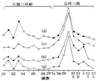
The source of the organic matter in the metallic deposit is one of the important and difficult issues for the research into the biological mineralization. Relatively great differences, especially in terms of organic group constituents, w(C23)/w(C21) ratios of tricyclicterpanes, w(Ts)/w(Tm) ratios of triterpene, w(γ-cerotene)/w(C31αβS-hopane) ratios, and steranes series, are present between the organic matter in the metallogenic fluid in the Qixiashan polymetallic deposit, Nanjing occurring in the Carboniferous dolomites, and that, present as marine petroleum, adsorbed in the Upper and Lower Paleozoic hydrocarbon source rocks in the lower Yangtze region. However, the organic matter in the fluid is similar in several aspects to the enclosed organic matter in the Cambrian carbonate rocks (i.e., one of the mineral source strata), since the two kinds of organic matters are related to each other in their origin.
The source of the organic matter in the metallic deposit is one of the important and difficult issues for the research into the biological mineralization. Relatively great differences, especially in terms of organic group constituents, w(C23)/w(C21) ratios of tricyclicterpanes, w(Ts)/w(Tm) ratios of triterpene, w(γ-cerotene)/w(C31αβS-hopane) ratios, and steranes series, are present between the organic matter in the metallogenic fluid in the Qixiashan polymetallic deposit, Nanjing occurring in the Carboniferous dolomites, and that, present as marine petroleum, adsorbed in the Upper and Lower Paleozoic hydrocarbon source rocks in the lower Yangtze region. However, the organic matter in the fluid is similar in several aspects to the enclosed organic matter in the Cambrian carbonate rocks (i.e., one of the mineral source strata), since the two kinds of organic matters are related to each other in their origin.

2000, 25(1): 15-20.
Abstract:
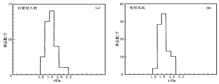
The Lüliang orogeny (1.9-1.7 Ga) has long been thought to have been responsible for the cratonization of the North China craton (NCC). In fact, the NCC was dominated in the late Palaeoproterozoic by an extensional-tectonic regime, associated with the development of an aulacogen system, anorogenic magmatism (rapakivi granites, anorthosites, gabbros, granites and pegmatites), with the emplacement of large-scale mafic dyke swarms and with the uplift of the early metamorphic basement or the tectonothermal events of the retrogressive metamorphism. The statistical analysis of the known isotopic age data of the late Palaeoproterozoic to early Mesoproterozoic rocks suggests that several age peaks are revealed by the chronological distributions of the magmatic emplacement and basement tectonothermal events and that the uplift and retrogressive metamorphic events of the craton basement lagged behind the magmatic emplacement, distinctively different from the structural deformation-metamorphism-magmatic emplacement sequences characteristic of orogenic belts. The re-understanding of the late Palaeoproterozoic extensional tectonic framework clarifies the most basic restricting condition for the reconstruction of North China craton within Rodinia in the Mesoproterozoic.
The Lüliang orogeny (1.9-1.7 Ga) has long been thought to have been responsible for the cratonization of the North China craton (NCC). In fact, the NCC was dominated in the late Palaeoproterozoic by an extensional-tectonic regime, associated with the development of an aulacogen system, anorogenic magmatism (rapakivi granites, anorthosites, gabbros, granites and pegmatites), with the emplacement of large-scale mafic dyke swarms and with the uplift of the early metamorphic basement or the tectonothermal events of the retrogressive metamorphism. The statistical analysis of the known isotopic age data of the late Palaeoproterozoic to early Mesoproterozoic rocks suggests that several age peaks are revealed by the chronological distributions of the magmatic emplacement and basement tectonothermal events and that the uplift and retrogressive metamorphic events of the craton basement lagged behind the magmatic emplacement, distinctively different from the structural deformation-metamorphism-magmatic emplacement sequences characteristic of orogenic belts. The re-understanding of the late Palaeoproterozoic extensional tectonic framework clarifies the most basic restricting condition for the reconstruction of North China craton within Rodinia in the Mesoproterozoic.


2000, 25(1): 21-27.
Abstract:
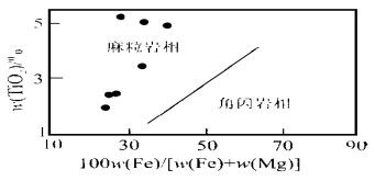
The mafic granulite xenolith was first reported to have occurred in Early Mesozoic diorite in Harkin region, Eastern Inner Mongolia Autonomous Region, China. The preliminary research indicates that the basic granulite xenoliths are different from the Precambrian granulite exposed on the earth surface of the North China craton. The electron microprobe analysis was performed of the four main rock-forming minerals: orthopyroxene, clinopyroxene, biotite and plagioclase, in comparison with those of Precambrian granulite terrain. The major focus is on the research into the chemical composition of various major rock-forming minerals. In addition, the metamorphic p-t conditions for the granulite xenoliths are discussed. The research results show that the metamorphism of the xenoliths had reached the granulite facies at the metamorphic temperatures ranging from 850 ℃ to 900 ℃ and at the metamorphic pressures ranging from 0.6 GPa to 1.0 GPa. These mafic granulite xenoliths reflect the component features of the Early Mesozoic continental lower crust of the research region, providing some evidence for the reconstruction of the Early Mesozoic deep crustal structure.
The mafic granulite xenolith was first reported to have occurred in Early Mesozoic diorite in Harkin region, Eastern Inner Mongolia Autonomous Region, China. The preliminary research indicates that the basic granulite xenoliths are different from the Precambrian granulite exposed on the earth surface of the North China craton. The electron microprobe analysis was performed of the four main rock-forming minerals: orthopyroxene, clinopyroxene, biotite and plagioclase, in comparison with those of Precambrian granulite terrain. The major focus is on the research into the chemical composition of various major rock-forming minerals. In addition, the metamorphic p-t conditions for the granulite xenoliths are discussed. The research results show that the metamorphism of the xenoliths had reached the granulite facies at the metamorphic temperatures ranging from 850 ℃ to 900 ℃ and at the metamorphic pressures ranging from 0.6 GPa to 1.0 GPa. These mafic granulite xenoliths reflect the component features of the Early Mesozoic continental lower crust of the research region, providing some evidence for the reconstruction of the Early Mesozoic deep crustal structure.


2000, 25(1): 28-32.
Abstract:
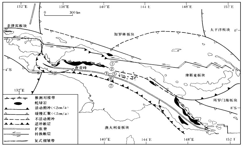
The Peak Jaya and its neighboring areas within the New Guinea island in Oceania are located at the junction of several lithospheric plates: Pacific plate, Australian plate and Southeast Asian plate. In the Peak Jaya are present a concentration of tectonic stress, an intensification of tectonic disturbance and a complicate tectonic evolution history. The mountain building of Peak Jaya is a product of subduction of north Australian passive continental margin into the area below the Melanesian island arc since the Miocene. Since 2.8 Ma, the rock uplift amplitude of the Peak Jaya has reached about 7 000 m with the uplift rate 2.5 mm/a and the exhumation rate 0.7 mm/a.Based on the dating of the Carboniferous-Permian obtained in the southern slope of Peak Jaya, the rock uplift amplitude has reached, since 2.3 Ma, 6 500 m with the uplift rate 2.8 mm/a and exhumation rate 1.7 mm/a. Further to the south, there exists a greenschist domain of probably Precambrian. The exhumation rate there has reached a faster rate, since the exhumed depth has already reached 9 km, the deepest part of the whole island. It is this violent down-cutting and exhumation that has made Peak Jaya the highest peak in Oceania by means of equilibrium elevation.
The Peak Jaya and its neighboring areas within the New Guinea island in Oceania are located at the junction of several lithospheric plates: Pacific plate, Australian plate and Southeast Asian plate. In the Peak Jaya are present a concentration of tectonic stress, an intensification of tectonic disturbance and a complicate tectonic evolution history. The mountain building of Peak Jaya is a product of subduction of north Australian passive continental margin into the area below the Melanesian island arc since the Miocene. Since 2.8 Ma, the rock uplift amplitude of the Peak Jaya has reached about 7 000 m with the uplift rate 2.5 mm/a and the exhumation rate 0.7 mm/a.Based on the dating of the Carboniferous-Permian obtained in the southern slope of Peak Jaya, the rock uplift amplitude has reached, since 2.3 Ma, 6 500 m with the uplift rate 2.8 mm/a and exhumation rate 1.7 mm/a. Further to the south, there exists a greenschist domain of probably Precambrian. The exhumation rate there has reached a faster rate, since the exhumed depth has already reached 9 km, the deepest part of the whole island. It is this violent down-cutting and exhumation that has made Peak Jaya the highest peak in Oceania by means of equilibrium elevation.


2000, 25(1): 33-38.
Abstract:
Fanshaped sedimentary bodies are important oil-gas accumulation bodies for the Mesozoic and Cenozoic oil- and gas-bearing basins in the inland and offshore of China. The quantified characterization of the spatial distribution pattern of the sedimentary bodies and that of the spatial variation principle of the inner structure parameters, are of important significance to the oil and gas exploration. The growth process of a fan-shaped sedimentary body is a complex nonlinear dynamic process. The analysis of the sedimentary dynamic, chaotic dynamic and fractal dynamic mechanisms of the growth process concludes that the growth process of the fan-shaped sedimentary bodies has fractal features. The crevasse process is an important cause for the complex and changing surface shapes of the sedimentary bodies. The fractal geometry theory will be relatively well applied to the quantitative modeling and simulation of the sedimentary bodies. The combination of fractal with geostatistics is applied to simulation the surface shapes and internal structures of the fan-shaped sedimentary bodies. In addition, a discussion of the simulation results is presented.
Fanshaped sedimentary bodies are important oil-gas accumulation bodies for the Mesozoic and Cenozoic oil- and gas-bearing basins in the inland and offshore of China. The quantified characterization of the spatial distribution pattern of the sedimentary bodies and that of the spatial variation principle of the inner structure parameters, are of important significance to the oil and gas exploration. The growth process of a fan-shaped sedimentary body is a complex nonlinear dynamic process. The analysis of the sedimentary dynamic, chaotic dynamic and fractal dynamic mechanisms of the growth process concludes that the growth process of the fan-shaped sedimentary bodies has fractal features. The crevasse process is an important cause for the complex and changing surface shapes of the sedimentary bodies. The fractal geometry theory will be relatively well applied to the quantitative modeling and simulation of the sedimentary bodies. The combination of fractal with geostatistics is applied to simulation the surface shapes and internal structures of the fan-shaped sedimentary bodies. In addition, a discussion of the simulation results is presented.


2000, 25(1): 39-43.
Abstract:
This paper is focused on the provenance evolution and migration of Triassic and Jurassic Awat-Manjia'er depression of the Tarim basin. The compositional analysis of sandstone and conglomerate suggests that the adjacent orogenic zone including the Shaya forebulge was gradually uplifted with the exhumation of the Paleozoic. The analysis based on lithofacies distribution suggests that the surrounding provenances including the Shaya forebulge rotated anti-clockwise contemporaneously with the subsidence center. This rotation may be caused by the clockwise rotation of the Tarim basin.
This paper is focused on the provenance evolution and migration of Triassic and Jurassic Awat-Manjia'er depression of the Tarim basin. The compositional analysis of sandstone and conglomerate suggests that the adjacent orogenic zone including the Shaya forebulge was gradually uplifted with the exhumation of the Paleozoic. The analysis based on lithofacies distribution suggests that the surrounding provenances including the Shaya forebulge rotated anti-clockwise contemporaneously with the subsidence center. This rotation may be caused by the clockwise rotation of the Tarim basin.


2000, 25(1): 44-50.
Abstract:
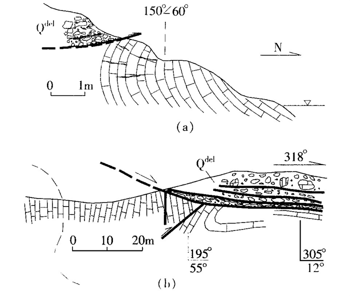
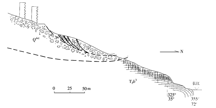
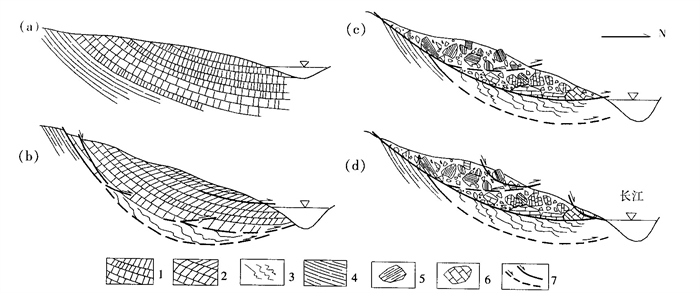
In 1995 two landslidesin the Huangtupo slope in the Three Gorges Reservoir region turned into a hot issue among the engineering geologists and the Chinese government.Although many researches have been made into the slope, there are still many controversiesover the characteristicsof the Huangtupo slope. Is the Huangtupo slope in the new county of Badong, Three Gorges Reservoir region an ancient landslide? If so, what was the scale of this ancient landslide? What is the relationship between the new landslides and the old landslides? The present paper proposes, on the basis of a great number of field observation references, the slope evolutionary pattern of deformation and instability in the multi_stages of down_slope overlapping, lands-liding, and modification. Before the landslide, the Huangtupo slope experienced the long_term down_slope overlapping classified as included toppling and deep_seated creeping, two basic slope deformation forms. The Huangtupo landslide, derived from the preceding down_slope overlapping, brought about the step_like land-form. The significant evidences for the landslide are the varied attitudesof structural surfaces and linesof out-crops in the slope and the presence of the sliding breccia zones.Since then, the Huangtupo landslide hasexpe-rienced small_scale overlapping modifications of landslides. The two landslides that occurred in 1995 were the result of the further modification. It is concluded that the rock slope deformation process of down_slope over-lapping_landsliding_modification is an organic one. This conclusion presents us with relatively precise under-standing of some important issues about the Huangtupo landslide and also with a typical example of the appli-cation of the tectonics to the research into slopes.
In 1995 two landslidesin the Huangtupo slope in the Three Gorges Reservoir region turned into a hot issue among the engineering geologists and the Chinese government.Although many researches have been made into the slope, there are still many controversiesover the characteristicsof the Huangtupo slope. Is the Huangtupo slope in the new county of Badong, Three Gorges Reservoir region an ancient landslide? If so, what was the scale of this ancient landslide? What is the relationship between the new landslides and the old landslides? The present paper proposes, on the basis of a great number of field observation references, the slope evolutionary pattern of deformation and instability in the multi_stages of down_slope overlapping, lands-liding, and modification. Before the landslide, the Huangtupo slope experienced the long_term down_slope overlapping classified as included toppling and deep_seated creeping, two basic slope deformation forms. The Huangtupo landslide, derived from the preceding down_slope overlapping, brought about the step_like land-form. The significant evidences for the landslide are the varied attitudesof structural surfaces and linesof out-crops in the slope and the presence of the sliding breccia zones.Since then, the Huangtupo landslide hasexpe-rienced small_scale overlapping modifications of landslides. The two landslides that occurred in 1995 were the result of the further modification. It is concluded that the rock slope deformation process of down_slope over-lapping_landsliding_modification is an organic one. This conclusion presents us with relatively precise under-standing of some important issues about the Huangtupo landslide and also with a typical example of the appli-cation of the tectonics to the research into slopes.

2000, 25(1): 51-56.
Abstract:
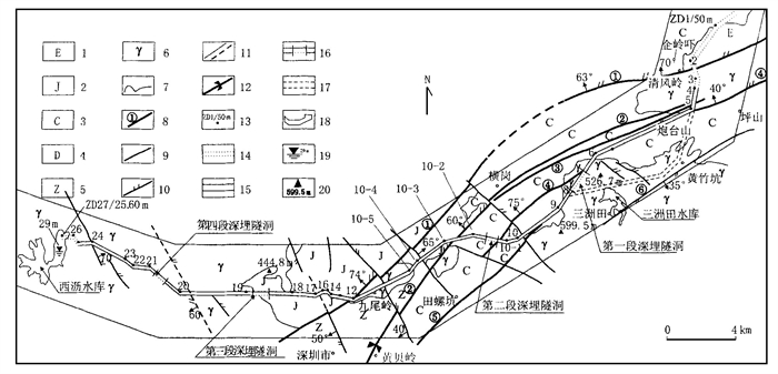
This paper presents the analysis of the present-day structural activity of the Shenzhen fracture zone in terms of the micro-seismicity, fault displacement monitoring and present-day crustal stress measurements. A numerical simulation of the present-day three-dimensional tectonic stress field was then used to make a quantitative calculation of the present-day activity magnitude range at the intersection between the Shenzhen fault zone and the water diversion tunnel, and the included angle between the axial orientations in different parts of the water diversion tunnel and the maximum horizontal principal compressive stress, and to infer the present-day structural stress state of the deeply-buried sectors of the water diversion tunnel. The research results both in seismic activities and risks and in rock and soil stability can be used by means of fuzzy mathematics to assess the crustal stability of the water diversion tunnel project, providing a basis for the engineering designing and construction.
This paper presents the analysis of the present-day structural activity of the Shenzhen fracture zone in terms of the micro-seismicity, fault displacement monitoring and present-day crustal stress measurements. A numerical simulation of the present-day three-dimensional tectonic stress field was then used to make a quantitative calculation of the present-day activity magnitude range at the intersection between the Shenzhen fault zone and the water diversion tunnel, and the included angle between the axial orientations in different parts of the water diversion tunnel and the maximum horizontal principal compressive stress, and to infer the present-day structural stress state of the deeply-buried sectors of the water diversion tunnel. The research results both in seismic activities and risks and in rock and soil stability can be used by means of fuzzy mathematics to assess the crustal stability of the water diversion tunnel project, providing a basis for the engineering designing and construction.


2000, 25(1): 57-60.
Abstract:
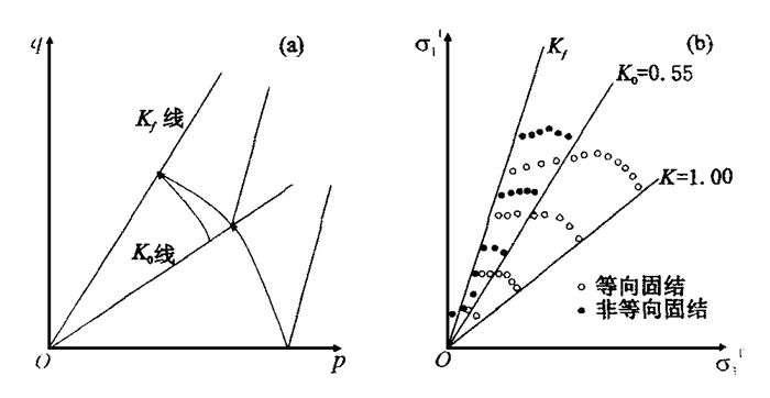
Following a new pore-water pressure equation and two different assumptions, two different relationships between A f and C u with K 0 are established and compared with each other. In addition, the undrained shear strength feature obtained in line with the corresponding assumption is presented.
Following a new pore-water pressure equation and two different assumptions, two different relationships between A f and C u with K 0 are established and compared with each other. In addition, the undrained shear strength feature obtained in line with the corresponding assumption is presented.

2000, 25(1): 61-65.
Abstract:
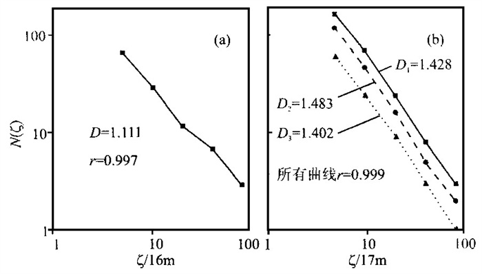
In order to discover a new approach to the quantitative analysis of the evolution and stability of the complex landslide trace pattern, the fractal theory is employed to analyze the geometrical fractal pattern of the self-similar boundary trace between the Huanglashi landslide and the Huangtupo landslide in the fore-reservoir region of the Three Gorges, Changjiang River. In addition, the box dimension method is employed to obtain the characteristic slope curves and fractal values for the corresponding fractal patterns of the active landslide cluster in the west of the Huanglashi landslide, the small landslide cluster in the east of the Huanglashi landslide, the whole landslide system of the Huanglashi landslide, and the Huangtupo landslide respectively. The computation results show that the trace pattern of each landslide cluster is characterized by its characteristic fractal value. The more complex the trace pattern, the clearer the structure layers, and the higher the fractal value. In particular, the highest fractal value is D =1.483 located in the active landslide cluster in the west of the Huanglashi landslide, and the lowest fractal value D =1.111 located in the Huangtupo landslide. The fractal analysis of the Huangtupo landslide and the Huanglashi landslide provides us with the following major conclusions: (1) The statistical self-similarity and the fractal structure are both present in the boundary trace between the landslides. (2) The macro-extension deformation process of the landslide trace pattern is characterized by the increase in the dimension instead of the decrease in the dimension. (3) The more complex the landslide trace pattern, the better the sequential order, the higher the fractal value, and the poorer the stability of the corresponding landslide. Therefore, the fractal dimension may serve as a statistical assessment criterion for the analysis of the complexity and stability of the landslide trace pattern.
In order to discover a new approach to the quantitative analysis of the evolution and stability of the complex landslide trace pattern, the fractal theory is employed to analyze the geometrical fractal pattern of the self-similar boundary trace between the Huanglashi landslide and the Huangtupo landslide in the fore-reservoir region of the Three Gorges, Changjiang River. In addition, the box dimension method is employed to obtain the characteristic slope curves and fractal values for the corresponding fractal patterns of the active landslide cluster in the west of the Huanglashi landslide, the small landslide cluster in the east of the Huanglashi landslide, the whole landslide system of the Huanglashi landslide, and the Huangtupo landslide respectively. The computation results show that the trace pattern of each landslide cluster is characterized by its characteristic fractal value. The more complex the trace pattern, the clearer the structure layers, and the higher the fractal value. In particular, the highest fractal value is D =1.483 located in the active landslide cluster in the west of the Huanglashi landslide, and the lowest fractal value D =1.111 located in the Huangtupo landslide. The fractal analysis of the Huangtupo landslide and the Huanglashi landslide provides us with the following major conclusions: (1) The statistical self-similarity and the fractal structure are both present in the boundary trace between the landslides. (2) The macro-extension deformation process of the landslide trace pattern is characterized by the increase in the dimension instead of the decrease in the dimension. (3) The more complex the landslide trace pattern, the better the sequential order, the higher the fractal value, and the poorer the stability of the corresponding landslide. Therefore, the fractal dimension may serve as a statistical assessment criterion for the analysis of the complexity and stability of the landslide trace pattern.


2000, 25(1): 66-70.
Abstract:
The typical oil pollution in the saturated-unsaturated multi-layer media water-bearing system characteristic of Tiebutie Pool in Daqing City is chosen as the object of the present investigation. On the base of the analysis of the hydrogeological data, the permeability law of the aquitard linking the upper and lower water-bearing beds in the water-bearing system has been achieved by an experimental research. Then the numerical simulation model of the oil pollutant migration in this kind of water-bearing system is constructed by means of the numerical simulation technology. The numerical model thus established can be used to forecast the pollution trend of the pollutants and to propose the corresponding measures to control the pollution. In summary, this research result is of wide application in China where the sustainable development strategy is strongly upheld.
The typical oil pollution in the saturated-unsaturated multi-layer media water-bearing system characteristic of Tiebutie Pool in Daqing City is chosen as the object of the present investigation. On the base of the analysis of the hydrogeological data, the permeability law of the aquitard linking the upper and lower water-bearing beds in the water-bearing system has been achieved by an experimental research. Then the numerical simulation model of the oil pollutant migration in this kind of water-bearing system is constructed by means of the numerical simulation technology. The numerical model thus established can be used to forecast the pollution trend of the pollutants and to propose the corresponding measures to control the pollution. In summary, this research result is of wide application in China where the sustainable development strategy is strongly upheld.


2000, 25(1): 71-78.
Abstract:
This paper presents the advances and trends of the research into tectonics-fluids-mineralization system and dynamics. On this basis, this paper tentatively proposes the theoretical framework and methodological system of the tectonics-fluids-mineralization system and dynamics. The tectonics-fluids-mineralization system is defined as an entity comprising of all geological factors and processes controlling and transforming the formation and preservation of ore deposits and their products. With tectonics-fluids playing a leading role, this system is also defined as a complex dynamic system occurring in a certain spatial-temporal zone and consisting of the coupling and telescoping of components and processes. The corresponding dynamics is defined here as the dynamic system/mechanism of mineralization system settings, mineralization system itself and ore-forming materials. This system includes the kinetic and geometric features of ore-forming structures, fluids and materials, and the differences between ore-forming process, potential to accumulate ore-forming materials and ore-forming products. This system highlights the importance of tectonics and fluids in the ore-forming process and stresses the entity and comprehensive effects initiated by the coupling and telescoping of components and processes. In this sense, this paper points out that the tectonics-fluids-mineralization system is characterized by gradation-entity, complexity, self-organizing criticality, network, orientation and optimum structure with the gradation-entity the most important feature. Guided by the theory about this system, the authors of the present paper propose that the tectonics-fluids-mineralization system and its dynamics should be viewed as a whole body and the formation process and dynamic feature of the tectonics -fluids-mineralization system should be under investigation in terms of the interaction between fluids and petrology-tectonic environment and also of the evolution of the tectonics-fluids. Following the principle of practice-recognition-re-practice-re-recognition and guided by the macroscopic theory of entity based on the multi-discipline researches, this paper presents the deep analysis of the principle of the spatial-temporal trace of a typical mineralization system that was viewed between the microscopic and macroscopic extremes. The principle thus concluded can be used to guide the research into the microscopic mineralization process and mechanism, to actualize the system, entity, and quantification of the present research, and to understand within a wider range and a deeper layer the spatial-temporal structure and nature of the tectonics-fluids-mineralization system.
This paper presents the advances and trends of the research into tectonics-fluids-mineralization system and dynamics. On this basis, this paper tentatively proposes the theoretical framework and methodological system of the tectonics-fluids-mineralization system and dynamics. The tectonics-fluids-mineralization system is defined as an entity comprising of all geological factors and processes controlling and transforming the formation and preservation of ore deposits and their products. With tectonics-fluids playing a leading role, this system is also defined as a complex dynamic system occurring in a certain spatial-temporal zone and consisting of the coupling and telescoping of components and processes. The corresponding dynamics is defined here as the dynamic system/mechanism of mineralization system settings, mineralization system itself and ore-forming materials. This system includes the kinetic and geometric features of ore-forming structures, fluids and materials, and the differences between ore-forming process, potential to accumulate ore-forming materials and ore-forming products. This system highlights the importance of tectonics and fluids in the ore-forming process and stresses the entity and comprehensive effects initiated by the coupling and telescoping of components and processes. In this sense, this paper points out that the tectonics-fluids-mineralization system is characterized by gradation-entity, complexity, self-organizing criticality, network, orientation and optimum structure with the gradation-entity the most important feature. Guided by the theory about this system, the authors of the present paper propose that the tectonics-fluids-mineralization system and its dynamics should be viewed as a whole body and the formation process and dynamic feature of the tectonics -fluids-mineralization system should be under investigation in terms of the interaction between fluids and petrology-tectonic environment and also of the evolution of the tectonics-fluids. Following the principle of practice-recognition-re-practice-re-recognition and guided by the macroscopic theory of entity based on the multi-discipline researches, this paper presents the deep analysis of the principle of the spatial-temporal trace of a typical mineralization system that was viewed between the microscopic and macroscopic extremes. The principle thus concluded can be used to guide the research into the microscopic mineralization process and mechanism, to actualize the system, entity, and quantification of the present research, and to understand within a wider range and a deeper layer the spatial-temporal structure and nature of the tectonics-fluids-mineralization system.


2000, 25(1): 79-82.
Abstract:
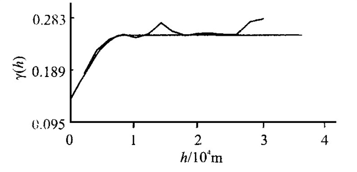
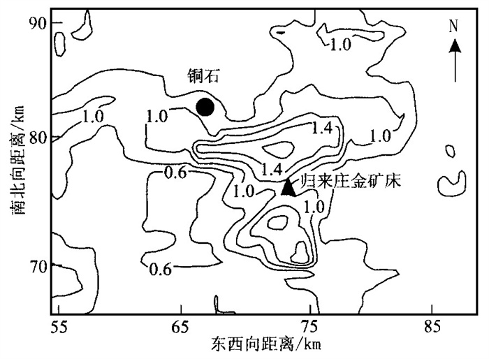
The w (Au) / w (Ag) ratio, an important indicator for the evaluation of gold deposits, may provide us with some important information on the origin of the gold deposits. This paper presents the geostatistical research into w (Au) / w (Ag) anomaly in the Guilaizhuang gold deposit. The indicator Kriging method is applied to the research into the distribution pattern of w (Au) / w (Ag) ratio and to the location of Au occurrence positions. Finally this paper presents some suggestions for the future research in this gold deposit.
The w (Au) / w (Ag) ratio, an important indicator for the evaluation of gold deposits, may provide us with some important information on the origin of the gold deposits. This paper presents the geostatistical research into w (Au) / w (Ag) anomaly in the Guilaizhuang gold deposit. The indicator Kriging method is applied to the research into the distribution pattern of w (Au) / w (Ag) ratio and to the location of Au occurrence positions. Finally this paper presents some suggestions for the future research in this gold deposit.


2000, 25(1): 83-87.
Abstract:
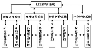
The REES structural model is a theoretical model for the resources-environment-economy-society evaluation system. The nontraditional mining evaluation system is the application of the nontraditional mineral resources theory to the mining evaluation. The REES structural model-based nontraditional mining evaluation can be defined as the integrated evaluation in terms of the sustainable development on the basis of the REES structural model.
The REES structural model is a theoretical model for the resources-environment-economy-society evaluation system. The nontraditional mining evaluation system is the application of the nontraditional mineral resources theory to the mining evaluation. The REES structural model-based nontraditional mining evaluation can be defined as the integrated evaluation in terms of the sustainable development on the basis of the REES structural model.


2000, 25(1): 88-92.
Abstract:
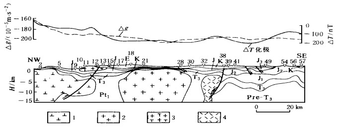
The comprehensive geological and geophysical interpretation of one measuring line in Basin C is applied to the determination of the distribution pattern of the Tertiary, the Cretaceous, the Jurassic and the Upper Triassic, a target stratum, and to the identification of several masses of igneous rocks, and several local structures. This section is classified as southern and northern parts along a reverse fault. A great difference arises between the southern and the northern parts of the section. The Upper Triassic in the northern part is thinner in thickness, shallower in burial depth, and weaker in deformation than that in the southern part. In conclusion, the deeper understanding of the comprehensive geological and geophysical interpretation may help us to obtain a better geological result.
The comprehensive geological and geophysical interpretation of one measuring line in Basin C is applied to the determination of the distribution pattern of the Tertiary, the Cretaceous, the Jurassic and the Upper Triassic, a target stratum, and to the identification of several masses of igneous rocks, and several local structures. This section is classified as southern and northern parts along a reverse fault. A great difference arises between the southern and the northern parts of the section. The Upper Triassic in the northern part is thinner in thickness, shallower in burial depth, and weaker in deformation than that in the southern part. In conclusion, the deeper understanding of the comprehensive geological and geophysical interpretation may help us to obtain a better geological result.


2000, 25(1): 93-97.
Abstract:
The expression of the time-interval curve of the reflective waves is derived on the condition of the horizontal layered strata, indicating that the time-interval curve of the reflective waves is a time-shifted hyperbola in the layered strata. The processing of theoretical model and real data shows that the time-shifted normal moveout and stacking may produce a high-fidelity, high-resolution and accurate stacking image effect. At the same time, the interval velocity derived from the time-shift-corrected spectrum τ0 is more accurate than that derived from the traditional Dix-equation-calculated stacking. This method is not only used for the stacking image of the seismic data in complex area, but also for the flow chart of the high-resolution processing.
The expression of the time-interval curve of the reflective waves is derived on the condition of the horizontal layered strata, indicating that the time-interval curve of the reflective waves is a time-shifted hyperbola in the layered strata. The processing of theoretical model and real data shows that the time-shifted normal moveout and stacking may produce a high-fidelity, high-resolution and accurate stacking image effect. At the same time, the interval velocity derived from the time-shift-corrected spectrum τ0 is more accurate than that derived from the traditional Dix-equation-calculated stacking. This method is not only used for the stacking image of the seismic data in complex area, but also for the flow chart of the high-resolution processing.


2000, 25(1): 98-102.
Abstract:
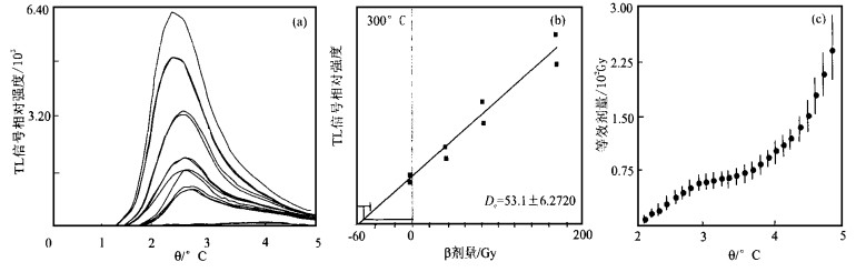
Seven samples of loess and paleosol collected from the major stratigraphic boundaries of the Weinan section, Shaanxi Province, have been dated using the fine-grain TL technique. Based on the TL results and previously ages-published from this section, the polynomial regression methods are applied to developing the high resolution timescale for the Weinan loess section in the Late Quaternary. According to this timescale, the ages of S0/L1-1, L1-1/L1-2, L1-4/L1-5, L1-5/S1 and S1/L2 stratigraphic boundary of Weinan section are 1.1, 2.5, 5.1, 7.6 and 12.8 ka. With exception of the maximum difference between the ages of L1-4/ L1-5 and the ages of 3/4 stage boundary of the deep-sea oxygen isotopes, they are generally consistentwith the ages of 1/2, 2/3, 4/5 and 5/6 stage boundary of the deep-sea oxygen isotopes in the SPECMAP curve.
Seven samples of loess and paleosol collected from the major stratigraphic boundaries of the Weinan section, Shaanxi Province, have been dated using the fine-grain TL technique. Based on the TL results and previously ages-published from this section, the polynomial regression methods are applied to developing the high resolution timescale for the Weinan loess section in the Late Quaternary. According to this timescale, the ages of S0/L1-1, L1-1/L1-2, L1-4/L1-5, L1-5/S1 and S1/L2 stratigraphic boundary of Weinan section are 1.1, 2.5, 5.1, 7.6 and 12.8 ka. With exception of the maximum difference between the ages of L1-4/ L1-5 and the ages of 3/4 stage boundary of the deep-sea oxygen isotopes, they are generally consistentwith the ages of 1/2, 2/3, 4/5 and 5/6 stage boundary of the deep-sea oxygen isotopes in the SPECMAP curve.


2000, 25(1): 103-106.
Abstract:
Geogas prospecting is an effective method for the location of the concealed gold deposit. In order to popularize this method, many experiments have been made in the known gas fields. The geogas prospecting has thus revealed the ring fracture structure 4 000 m deep and the location of the geogas anomaly above the ring fracture structure perpendicular to each other. In addition, two groupsof trace element anomalies in the soil, indirectly indicate the gas_bearing range. Finally, several kinds of high_resolution scanning-probe microscopes have been employed to observe the geogas anomaly. The results show that the substance deposited on the collectors occurs in the forms of nano-scale particles and their aggregate, providing us with the evidence for the research into the mechanism of the geogas anomaly.
Geogas prospecting is an effective method for the location of the concealed gold deposit. In order to popularize this method, many experiments have been made in the known gas fields. The geogas prospecting has thus revealed the ring fracture structure 4 000 m deep and the location of the geogas anomaly above the ring fracture structure perpendicular to each other. In addition, two groupsof trace element anomalies in the soil, indirectly indicate the gas_bearing range. Finally, several kinds of high_resolution scanning-probe microscopes have been employed to observe the geogas anomaly. The results show that the substance deposited on the collectors occurs in the forms of nano-scale particles and their aggregate, providing us with the evidence for the research into the mechanism of the geogas anomaly.


2000, 25(1): 107-110.
Abstract:
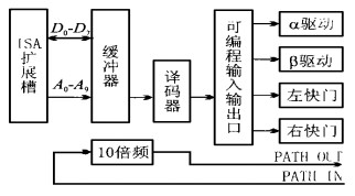
On the basis of the structural analysis of the pole figure attachment in X-ray diffractometer, this paper presents the method for upgrading this pole figure attachment, including the designing of computer interface and the application of the software program compatible to the WINDOWS95 operating system. In addition, this upgrading method also includes the system safety and the operational convenience.
On the basis of the structural analysis of the pole figure attachment in X-ray diffractometer, this paper presents the method for upgrading this pole figure attachment, including the designing of computer interface and the application of the software program compatible to the WINDOWS95 operating system. In addition, this upgrading method also includes the system safety and the operational convenience.