2000 Vol. 25, No. 2
Display Method:
2000, 25(2): 111-116.
 PDF 579KB
Abstract:
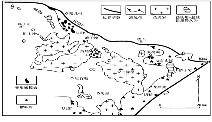
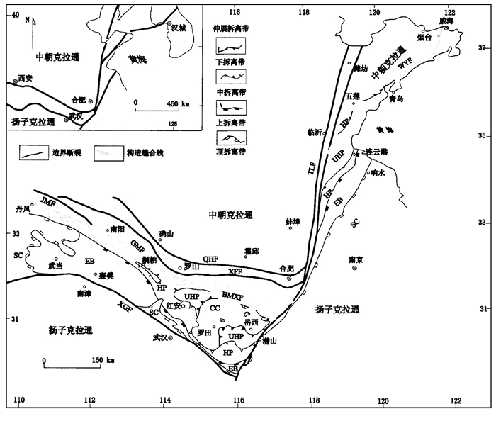
The distribution of ultrahigh pressure metamorphic (U HPM) and high pressure metamorphic (HPM) rocks and the geometrical relationship between various petrotectonic units in the Dabie-Sulu tectonic zone both indicate that the suture line that occurred when the Sino-Korean and Yangtze cratons collided and when the ultrahigh pressure and high pressure metamorphic rocks were generated, are situated at the northern margin of the Dabie massif.This suture line is distributed along the Balifan-Mozitan-Xiaotian fault, and possibly linked to the Wulian-Yantai fault, the position of the suture line violently modified in the Sulu region.The large-scale distribution of the U HP and HP metamorphic rocks near the boundary between Huoshan County and Yuexi County and in the adjacent area of Shucheng, Tongcheng and Qianshan counties in the north of Dabie Mountains, indicates that the Shuihou-Wuhe fault is not the northern limit of the U HP and HP eclogitic-facies rock.Therefore, this Shuihou-Wuhe fault does not represent the position of the suture line.In addition, the geological implication of the classification of the terrane as "Southern Dabie" and "Northern Dabie" is not accurate.At the same time, The mafic and ultramafic rock mass groups include the deformed harzburgite, pure peridotite assemblage and undeformed pyroxenite, bojite and gabbro assemblage. The first type of mafic-ultramafic rock bodies contain the same deformed and metamorphic and geometrical features as the eclogitic facies rocks.The second type of mafic-ultramafic rocks are intrusive bodies in the Yanshanian period (123-130Ma).Therefore, the mafic-ultramafic rocks are not defined as the "metamorphic ophiolitic mélange", or interpreted as the suture line in the T riassic continent-continent collision period.It is emphasized that the accurate identification of the position of the T riassic collision suture line is the key to the correct understanding of the formation and reciprocal dynamic process of the U HP and HP rocks.
The distribution of ultrahigh pressure metamorphic (U HPM) and high pressure metamorphic (HPM) rocks and the geometrical relationship between various petrotectonic units in the Dabie-Sulu tectonic zone both indicate that the suture line that occurred when the Sino-Korean and Yangtze cratons collided and when the ultrahigh pressure and high pressure metamorphic rocks were generated, are situated at the northern margin of the Dabie massif.This suture line is distributed along the Balifan-Mozitan-Xiaotian fault, and possibly linked to the Wulian-Yantai fault, the position of the suture line violently modified in the Sulu region.The large-scale distribution of the U HP and HP metamorphic rocks near the boundary between Huoshan County and Yuexi County and in the adjacent area of Shucheng, Tongcheng and Qianshan counties in the north of Dabie Mountains, indicates that the Shuihou-Wuhe fault is not the northern limit of the U HP and HP eclogitic-facies rock.Therefore, this Shuihou-Wuhe fault does not represent the position of the suture line.In addition, the geological implication of the classification of the terrane as "Southern Dabie" and "Northern Dabie" is not accurate.At the same time, The mafic and ultramafic rock mass groups include the deformed harzburgite, pure peridotite assemblage and undeformed pyroxenite, bojite and gabbro assemblage. The first type of mafic-ultramafic rock bodies contain the same deformed and metamorphic and geometrical features as the eclogitic facies rocks.The second type of mafic-ultramafic rocks are intrusive bodies in the Yanshanian period (123-130Ma).Therefore, the mafic-ultramafic rocks are not defined as the "metamorphic ophiolitic mélange", or interpreted as the suture line in the T riassic continent-continent collision period.It is emphasized that the accurate identification of the position of the T riassic collision suture line is the key to the correct understanding of the formation and reciprocal dynamic process of the U HP and HP rocks.
2000, 25(2): 117-121.
Abstract:
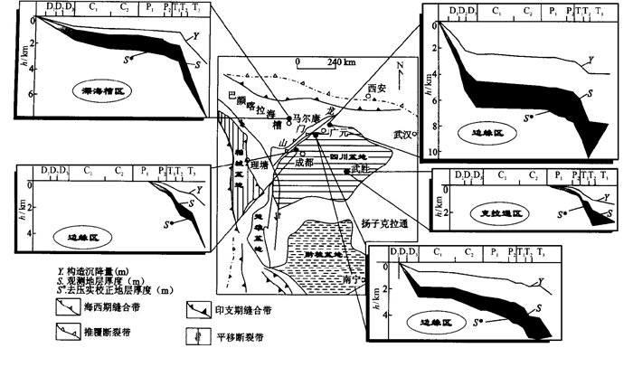
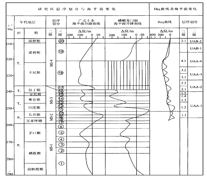
The stratigraphical sequences are considered as a medium to record sea-level changes. The effective accommodation space (C(t)), an accumulation strata for stratigraphic sequences, is a function of sea-level changes (L(t)), tectonic subsidence (Y(t)) and geological time (t). The research into the Permian-Triassic sequence stratigraphy in the western margin of the Upper Yangtze block, and the summary of previous research methods for the sea-level change curves both have been employed to establish the mathematical model of sea-level change curves, including mathematical geological model and mathematical function model. Firstly, the mathematical geological model of sea-level change curves: C(t)=L(t)+Y(t) is established, then the mathematical function model is proposed. The mathematical model has been used to compile quantitatively the Permian-Triassic seal-level change curves on the western margin of the Upper Yangtze block.
The stratigraphical sequences are considered as a medium to record sea-level changes. The effective accommodation space (C(t)), an accumulation strata for stratigraphic sequences, is a function of sea-level changes (L(t)), tectonic subsidence (Y(t)) and geological time (t). The research into the Permian-Triassic sequence stratigraphy in the western margin of the Upper Yangtze block, and the summary of previous research methods for the sea-level change curves both have been employed to establish the mathematical model of sea-level change curves, including mathematical geological model and mathematical function model. Firstly, the mathematical geological model of sea-level change curves: C(t)=L(t)+Y(t) is established, then the mathematical function model is proposed. The mathematical model has been used to compile quantitatively the Permian-Triassic seal-level change curves on the western margin of the Upper Yangtze block.

2000, 25(2): 122-126.
Abstract:
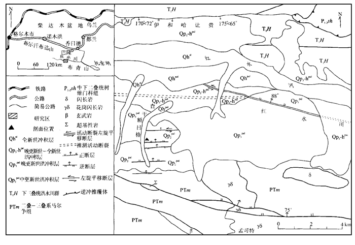
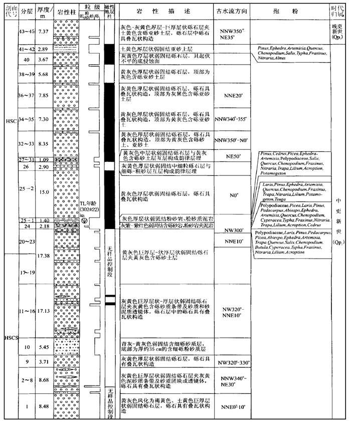
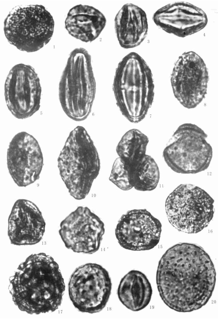
Buqingshan Mountains have already begun to rise abruptly on a large scale in the late Middle Pleistocene. The Quaternary deposit is more than 100 m thick in Chaganerige, northern slope of the Buqingshan Mountains, Kunlun Mountain Ranges. This deposit layer is defined as the multivariant complex formation of pluvial-alluvial fans, in the relatively fine sedimentary layers of which occur abundant sporomorphs. The analysis of plant sporopollen assemblage in the alluvial and pluvial formations is used to determine that the Quaternary pluvial-alluvial deposit occurred in the Middle Pleistocene. In addition, the plant type at that time reflected by the sporopollen assemblage is determined to be a mixedforestdesert steppe. The thermoluminescent dating of the pluvial-alluvial deposit is (302±22)?ka. The paleomagnetic measurement is used to identify two subtimes: Biwa reverse polarization No.1 and Biwa reverse polarization No.2, and also to identify the late Middle Pleistocene.
Buqingshan Mountains have already begun to rise abruptly on a large scale in the late Middle Pleistocene. The Quaternary deposit is more than 100 m thick in Chaganerige, northern slope of the Buqingshan Mountains, Kunlun Mountain Ranges. This deposit layer is defined as the multivariant complex formation of pluvial-alluvial fans, in the relatively fine sedimentary layers of which occur abundant sporomorphs. The analysis of plant sporopollen assemblage in the alluvial and pluvial formations is used to determine that the Quaternary pluvial-alluvial deposit occurred in the Middle Pleistocene. In addition, the plant type at that time reflected by the sporopollen assemblage is determined to be a mixedforestdesert steppe. The thermoluminescent dating of the pluvial-alluvial deposit is (302±22)?ka. The paleomagnetic measurement is used to identify two subtimes: Biwa reverse polarization No.1 and Biwa reverse polarization No.2, and also to identify the late Middle Pleistocene.

2000, 25(2): 127-131.
Abstract:
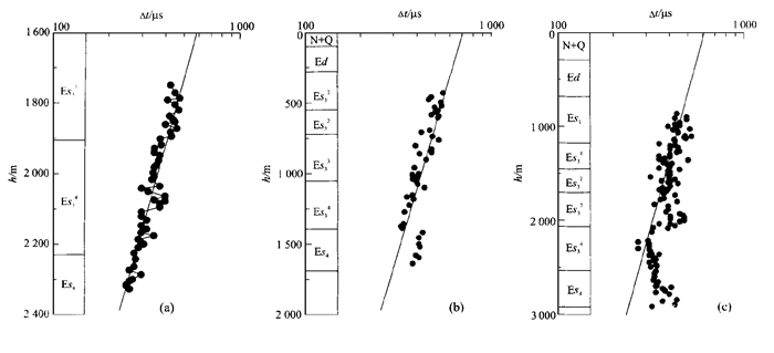
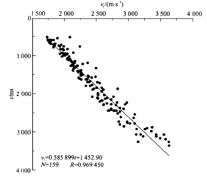
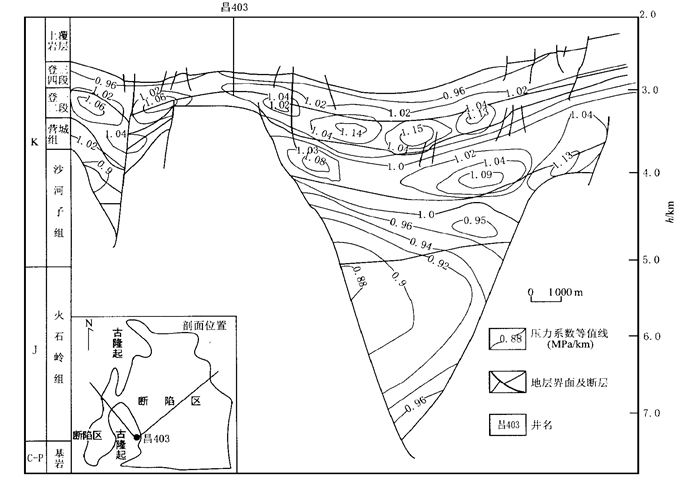
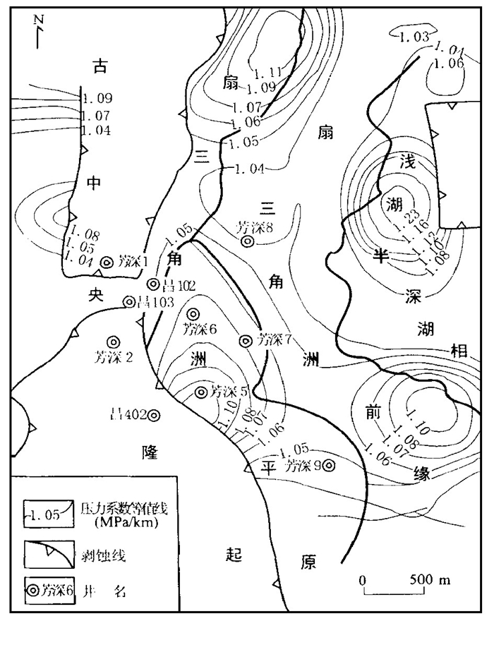
The mudstone sonic log interval, measured stratigraphic pressure and seismic data are integrated to analyze the underground fluid pressure fields in Damintun depression, Liaohe basin. The research results show the following six points: (1) The mudstone compaction in this region is classified as the following three types: normal compaction-normal pressure, under-compaction and low overpressure in one single interval, and under-compaction and high overpressure in double intervals. (2) The pressure gradient of the oil layers is approximate to 1, so it is often within the normal pressure system. (3) The characteristics of planes and profile pressure fields obtained through the seismic data are of a higher feasibility and reliability. (4) The current profile pressure system consists of normal pressure, low overpressure, and high overpressure from surface to the deep layers. The fault systems, unconformity surfaces, interconnecting pore systems and diapir structures constitute the complex network system of vertical and horizontal transportation within the depression. (5) A distinctive difference exists between the surplus pressures and pressure coefficients on both sides of the relatively large-scale faults controlling greatly the formation, evolution and distribution of the pressures. (6) The under-compaction and hydrocarbon generation are the leading mechanisms for the formation of the overpressure in this region.
The mudstone sonic log interval, measured stratigraphic pressure and seismic data are integrated to analyze the underground fluid pressure fields in Damintun depression, Liaohe basin. The research results show the following six points: (1) The mudstone compaction in this region is classified as the following three types: normal compaction-normal pressure, under-compaction and low overpressure in one single interval, and under-compaction and high overpressure in double intervals. (2) The pressure gradient of the oil layers is approximate to 1, so it is often within the normal pressure system. (3) The characteristics of planes and profile pressure fields obtained through the seismic data are of a higher feasibility and reliability. (4) The current profile pressure system consists of normal pressure, low overpressure, and high overpressure from surface to the deep layers. The fault systems, unconformity surfaces, interconnecting pore systems and diapir structures constitute the complex network system of vertical and horizontal transportation within the depression. (5) A distinctive difference exists between the surplus pressures and pressure coefficients on both sides of the relatively large-scale faults controlling greatly the formation, evolution and distribution of the pressures. (6) The under-compaction and hydrocarbon generation are the leading mechanisms for the formation of the overpressure in this region.

2000, 25(2): 133-136.
Abstract:
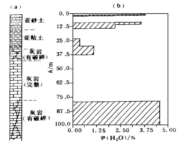
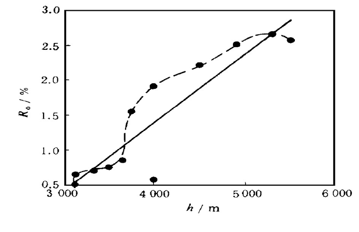
A large number of thermal fluid activities that occurred in Dongying sag can be proved in terms of gas geochemistry, organic matter thermal metamorphism, homogeneous temperature in fluid inclusions, palaeotemperature gradient, diagenetic mineral, heavy metal element and magmatic activity. The thermal fluids migrate along the deep and large faults whose activities are relatively strong to the shallow parts, and at the same time the corresponding migration pattern centers on the lateral forced convection. In addition, the thermal fluids in the Dongying sag are characterized by the multi-phase activities. The changes in temperature field and geothermal gradient and the mixture of some inorganic matters into the thermal fluids both result in the differences in water-rock interaction intensities and types.
A large number of thermal fluid activities that occurred in Dongying sag can be proved in terms of gas geochemistry, organic matter thermal metamorphism, homogeneous temperature in fluid inclusions, palaeotemperature gradient, diagenetic mineral, heavy metal element and magmatic activity. The thermal fluids migrate along the deep and large faults whose activities are relatively strong to the shallow parts, and at the same time the corresponding migration pattern centers on the lateral forced convection. In addition, the thermal fluids in the Dongying sag are characterized by the multi-phase activities. The changes in temperature field and geothermal gradient and the mixture of some inorganic matters into the thermal fluids both result in the differences in water-rock interaction intensities and types.

2000, 25(2): 137-142.
Abstract:
Pore-fluid pressure, a fluid state parameter, is one of important factors for the analysis of basin dynamics?, hydrocarbon reservoir and the prediction of oil and gas. The forecasting model of pore-fluid pressure should include various geological effects. At the same time, the relationship between numerous real stratigraphic testing parameters and various geophysical parameters is employed to choose an appropriate mathematical model. The present paper is focused on the prediction of oil and gas by means of neural network computing technique, and on the analysis of possible origins of pore-fluid pressure.
Pore-fluid pressure, a fluid state parameter, is one of important factors for the analysis of basin dynamics?, hydrocarbon reservoir and the prediction of oil and gas. The forecasting model of pore-fluid pressure should include various geological effects. At the same time, the relationship between numerous real stratigraphic testing parameters and various geophysical parameters is employed to choose an appropriate mathematical model. The present paper is focused on the prediction of oil and gas by means of neural network computing technique, and on the analysis of possible origins of pore-fluid pressure.
2000, 25(2): 143-146.
Abstract:
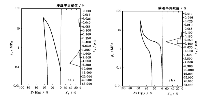
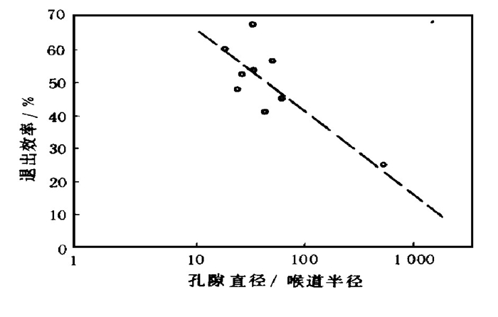
The testing methods, such as the volcanic rock thin section, the casting thin section, the scanning electron microscope and the porosity, permeability and mercury injection, are used in this paper to make researches into the reservoir properties of the Mesozoic volcanic rocks in the Rongxingtun region, Liaohe basin. The research results are used to draw the following six conclusions: (1) The reservoir space of the volcanic rocks is mainly composed of secondary pores, while the primary pores are often filled. (2) The pore throats are narrow, with the mean radium of an open pore ranging between 0.100-0.500?μm. The pore throats are distributed in the following two patterns: mono-peak and flat peak. (3) The major three pore assembly types are shown below: microfissure, microfissure-pore and pore, and are dominated by the first two types. (4) The porosity varies between 1.0%-16.3%, and the permeability between 0.012×10⁻³ -12×10-3 μm2. In this case, this reservoir is featured by the low porosity and the super-low permeability. (5) The reservoir is characterized by strong heterogeneity, low permeability gradation: 1?000, abrupt injection coefficient: 12.41 and variation coefficient: 2.3. The features mentioned above have been used to make a plan to classify the volcanic rock reservoirs. (6) Because of the relatively low ratio between pore and throat, the seceding efficiency of the volcanic rock reservoirs is relatively high, whose average value reaches 47.9%, showing the potential of a high oil and gas productivity.
The testing methods, such as the volcanic rock thin section, the casting thin section, the scanning electron microscope and the porosity, permeability and mercury injection, are used in this paper to make researches into the reservoir properties of the Mesozoic volcanic rocks in the Rongxingtun region, Liaohe basin. The research results are used to draw the following six conclusions: (1) The reservoir space of the volcanic rocks is mainly composed of secondary pores, while the primary pores are often filled. (2) The pore throats are narrow, with the mean radium of an open pore ranging between 0.100-0.500?μm. The pore throats are distributed in the following two patterns: mono-peak and flat peak. (3) The major three pore assembly types are shown below: microfissure, microfissure-pore and pore, and are dominated by the first two types. (4) The porosity varies between 1.0%-16.3%, and the permeability between 0.012×10⁻³ -12×10-3 μm2. In this case, this reservoir is featured by the low porosity and the super-low permeability. (5) The reservoir is characterized by strong heterogeneity, low permeability gradation: 1?000, abrupt injection coefficient: 12.41 and variation coefficient: 2.3. The features mentioned above have been used to make a plan to classify the volcanic rock reservoirs. (6) Because of the relatively low ratio between pore and throat, the seceding efficiency of the volcanic rock reservoirs is relatively high, whose average value reaches 47.9%, showing the potential of a high oil and gas productivity.
2000, 25(2): 147-151.
Abstract:
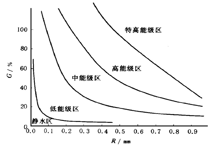
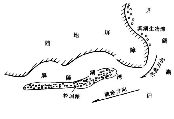
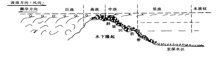
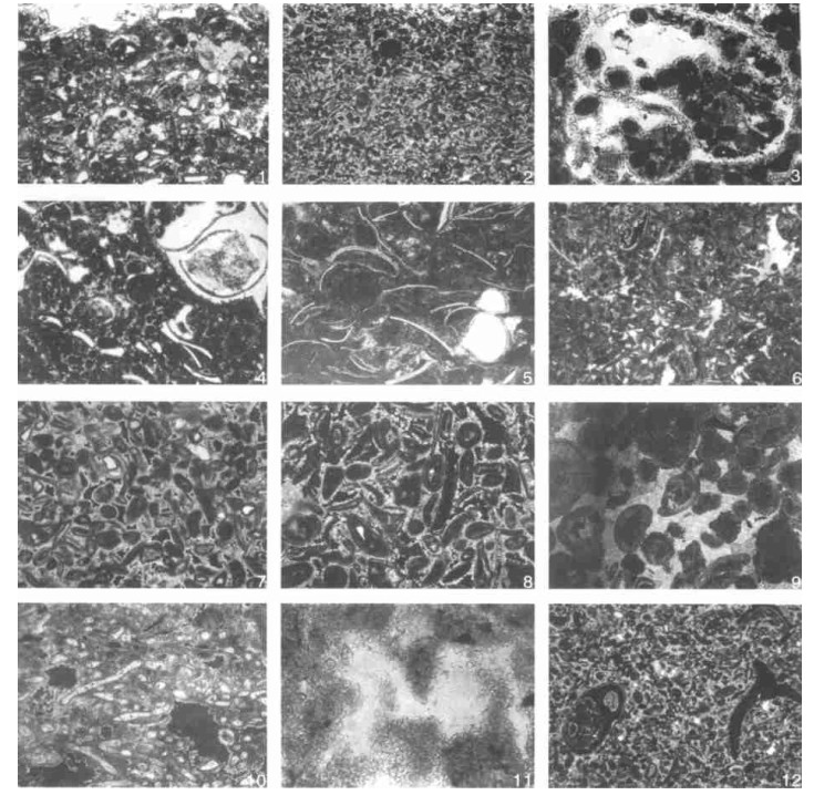
In this paper, the Paleogene grained carbonate rocks in the Shengli oilfield, east of China are divided into six types: oolitic dolomite, sand-clastic dolomite, gastrapod-clastic limestone or dolomite, ostracod-clastic dolomite, multigrain-filled matrix dolomite and calcareous sparry grain-clastic dolomite. The sedimentary mechanism of grain-clastic carbonate rocks is described herein based on the analysis of the disturbance and transportation process of grained clasts along the coast and around the platform, and on the determination of two types of energy-reducing topography caused by the subaqueous topographic rise in the barrier bay and the off-shore area. An empirical formula: W=RG, where R represents the average diameter of the grained clasts and G represents the percentage content of the grained clasts in the rocks, has been used to determine the W, a water-body energy index. This formula can also be used to identify five facies zones in this region: the super-high energy grade (W > 50), high energy grade (W : 25~50), medium energy grade (W : 10~25), low energy grade (W : 1~10) and static water grade (W < 1). The comparison coefficient (the sorted coefficient) can be used as an index to identify the wave energy and the water -body energy in a sedimentary zone. The carbonate reservoir can be divided into four types of permeability layers: primary superhigh, secondary high, secondary medium-low and primary low permeability layers, in line with the physical properties caused by the deposition and post-depositional reconstruction of the grain-clastic carbonate rocks.
In this paper, the Paleogene grained carbonate rocks in the Shengli oilfield, east of China are divided into six types: oolitic dolomite, sand-clastic dolomite, gastrapod-clastic limestone or dolomite, ostracod-clastic dolomite, multigrain-filled matrix dolomite and calcareous sparry grain-clastic dolomite. The sedimentary mechanism of grain-clastic carbonate rocks is described herein based on the analysis of the disturbance and transportation process of grained clasts along the coast and around the platform, and on the determination of two types of energy-reducing topography caused by the subaqueous topographic rise in the barrier bay and the off-shore area. An empirical formula: W=RG, where R represents the average diameter of the grained clasts and G represents the percentage content of the grained clasts in the rocks, has been used to determine the W, a water-body energy index. This formula can also be used to identify five facies zones in this region: the super-high energy grade (W > 50), high energy grade (W : 25~50), medium energy grade (W : 10~25), low energy grade (W : 1~10) and static water grade (W < 1). The comparison coefficient (the sorted coefficient) can be used as an index to identify the wave energy and the water -body energy in a sedimentary zone. The carbonate reservoir can be divided into four types of permeability layers: primary superhigh, secondary high, secondary medium-low and primary low permeability layers, in line with the physical properties caused by the deposition and post-depositional reconstruction of the grain-clastic carbonate rocks.
2000, 25(2): 152-158.
Abstract:
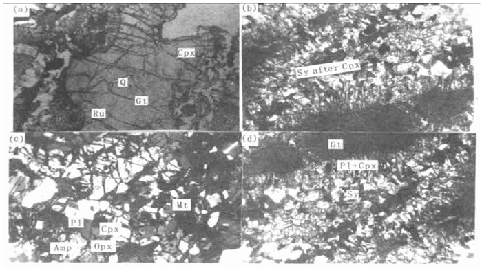
The lithofacies research, the calculation of the mineral and geological temperature and pressure, and the thermodynamic calculation are all used in this paper to obtain the mineral association assemblies?, the temperature and pressure conditions and the corresponding water activity conditions that occurred in the four major metamorphic evolutionary stages of the pyrigarnite in the Dabie Mountains: (1) The ecologite facies stage (M1) is characterized by the residual minerals represented by Cpx (jadeitebearing)+Q+Ru+Gt that occur as inclusions in the garnets at t =612-750 ℃. (2) The granulite facies stage (M2) is featured by the mineral assembly consisting of Opx+Cpx+Amp+Gt+Q+Ti+Mt at t =837-887 ℃, p =1.03-1.25?GPa. The water activity in this stage ranges between 0.718-0.799. (3) The amphibolite facies (M3) is characterized by the mineral assembly consisting of Cpx+Gt+Amp+ Pl+Mt at t =530-660 ℃ and p =0.89-0.95?GPa. The water activity in this stage was reduced to 0.23-0.24. (4) The low amphibolite facies (M4) occurred at t =495 ℃ and p =0.56-0.70?GPa. The water activity in this stage was 0.11-0.13. In conclusion, the metamorphic reaction, the metamorphic structure, the mineral assembly and evolution of the pyrigarnite are not only controlled by the temperature and pressure conditions, but also closely related in cause and effect to the evolution of water activity during its formation system. The evolutionary feature of the water activity shows that the metamorphic fluids may have played a buffering role in the metamorphic reaction temperature during the metamorphic stages.
The lithofacies research, the calculation of the mineral and geological temperature and pressure, and the thermodynamic calculation are all used in this paper to obtain the mineral association assemblies?, the temperature and pressure conditions and the corresponding water activity conditions that occurred in the four major metamorphic evolutionary stages of the pyrigarnite in the Dabie Mountains: (1) The ecologite facies stage (M1) is characterized by the residual minerals represented by Cpx (jadeitebearing)+Q+Ru+Gt that occur as inclusions in the garnets at t =612-750 ℃. (2) The granulite facies stage (M2) is featured by the mineral assembly consisting of Opx+Cpx+Amp+Gt+Q+Ti+Mt at t =837-887 ℃, p =1.03-1.25?GPa. The water activity in this stage ranges between 0.718-0.799. (3) The amphibolite facies (M3) is characterized by the mineral assembly consisting of Cpx+Gt+Amp+ Pl+Mt at t =530-660 ℃ and p =0.89-0.95?GPa. The water activity in this stage was reduced to 0.23-0.24. (4) The low amphibolite facies (M4) occurred at t =495 ℃ and p =0.56-0.70?GPa. The water activity in this stage was 0.11-0.13. In conclusion, the metamorphic reaction, the metamorphic structure, the mineral assembly and evolution of the pyrigarnite are not only controlled by the temperature and pressure conditions, but also closely related in cause and effect to the evolution of water activity during its formation system. The evolutionary feature of the water activity shows that the metamorphic fluids may have played a buffering role in the metamorphic reaction temperature during the metamorphic stages.
2000, 25(2): 159-162.
Abstract:
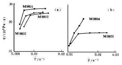
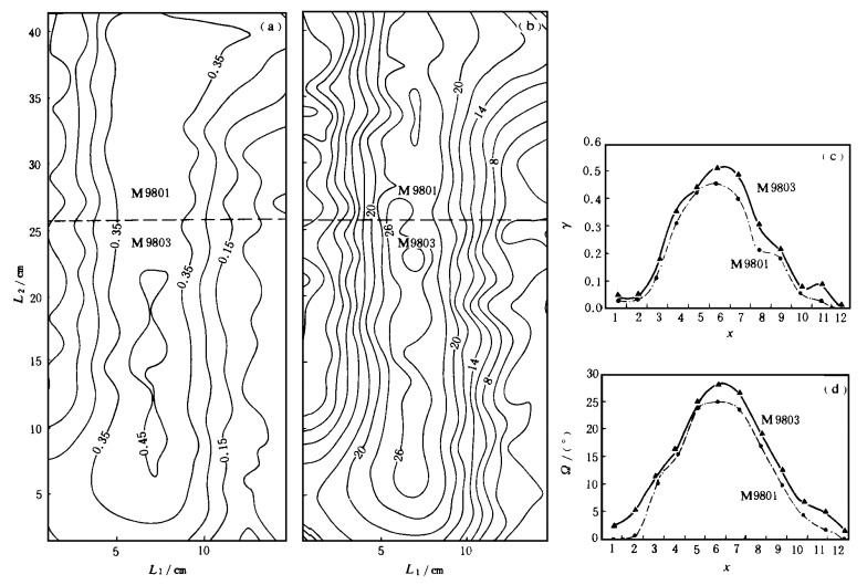
The tectonic simulation research indicates: (1) The grain size is one of important factors controlling the rheological behaviors of a rock. The coarser the grain of minerals in a rock, the higher the viscosity of the rock. (2) The lower the ratio of the granular mineral content to the matrix, the smaller the effect of the grain size to the rheological behaviors of the rock, and vice versa. (3) The difference between grain sizes of a rock affects greatly the development of a ductile shear zone. The finer the grain size, the greater the finite strain in the ductile shear zone. These conclusions are perfectly consistent with the geological phenomena observed in the field and the actual measurement of finite strain of rocks in the ductile shear zone.
The tectonic simulation research indicates: (1) The grain size is one of important factors controlling the rheological behaviors of a rock. The coarser the grain of minerals in a rock, the higher the viscosity of the rock. (2) The lower the ratio of the granular mineral content to the matrix, the smaller the effect of the grain size to the rheological behaviors of the rock, and vice versa. (3) The difference between grain sizes of a rock affects greatly the development of a ductile shear zone. The finer the grain size, the greater the finite strain in the ductile shear zone. These conclusions are perfectly consistent with the geological phenomena observed in the field and the actual measurement of finite strain of rocks in the ductile shear zone.
2000, 25(2): 163-171.
Abstract:
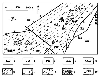
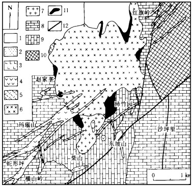
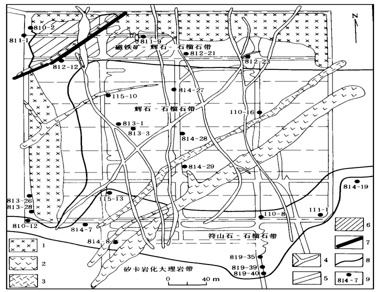
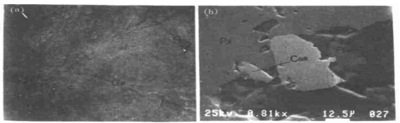
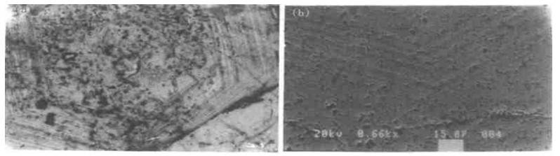
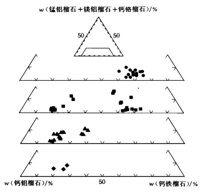
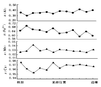
In the Shizhuyuan polymetallic skarn deposit in Hunan Province, China, the research for garnet is made by means of the field survey, the microscopic observation and EPMA. This skarn is classified into four zonal distributions in terms of the occurrence of the garnet and the mineral assemblages: magnetite-yroxene-arnet zone, pyroxene-arnet zone, vesuvianite-arnet zone and skarnized marble zone. The features of the garnet in various skarnized zones are discussed with changes of chemical composition and mode of occurrence. The garnet is divided into two stages: early and late stages. During the early stage, the color of the garnet is dark brown, and shows a distinctive zonal pattern with various chemical compositions. In addition, the magnetite-yroxene-arnet zone to skarnized marble zone has transformed from andradite to grossular as the content of Fe2O3 decreases and that of Al2O3 increases. The garnet crystal is characterized by the pattern of compositional changes from core to rim. During the early stage, the garnet occurred in the relatively oxidizing environment at the temperature ranging between 520 and 620 ℃ and at the pressure of 1 000×105 Pa. In addition, this garnet resulted from the metasomatic reaction between the thermal liquids of Si, Al, Fe, Cl, F components and the Devonian limestone of the Shetianqiao Formation. When the temperature falls to 450-540 ℃ and the pH and Eh values decrease in the late stage, the garnet occured with sheelite. The color of the garnet crystal in the late stage is red, and is lighter than that of the early stage. Furthermore, the crystal grain size is larger, and the zonal structure can be universally observed in the late stage.
In the Shizhuyuan polymetallic skarn deposit in Hunan Province, China, the research for garnet is made by means of the field survey, the microscopic observation and EPMA. This skarn is classified into four zonal distributions in terms of the occurrence of the garnet and the mineral assemblages: magnetite-yroxene-arnet zone, pyroxene-arnet zone, vesuvianite-arnet zone and skarnized marble zone. The features of the garnet in various skarnized zones are discussed with changes of chemical composition and mode of occurrence. The garnet is divided into two stages: early and late stages. During the early stage, the color of the garnet is dark brown, and shows a distinctive zonal pattern with various chemical compositions. In addition, the magnetite-yroxene-arnet zone to skarnized marble zone has transformed from andradite to grossular as the content of Fe2O3 decreases and that of Al2O3 increases. The garnet crystal is characterized by the pattern of compositional changes from core to rim. During the early stage, the garnet occurred in the relatively oxidizing environment at the temperature ranging between 520 and 620 ℃ and at the pressure of 1 000×105 Pa. In addition, this garnet resulted from the metasomatic reaction between the thermal liquids of Si, Al, Fe, Cl, F components and the Devonian limestone of the Shetianqiao Formation. When the temperature falls to 450-540 ℃ and the pH and Eh values decrease in the late stage, the garnet occured with sheelite. The color of the garnet crystal in the late stage is red, and is lighter than that of the early stage. Furthermore, the crystal grain size is larger, and the zonal structure can be universally observed in the late stage.
2000, 25(2): 172-178.
Abstract:
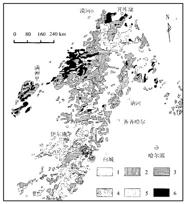
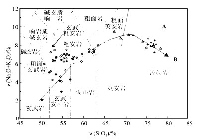
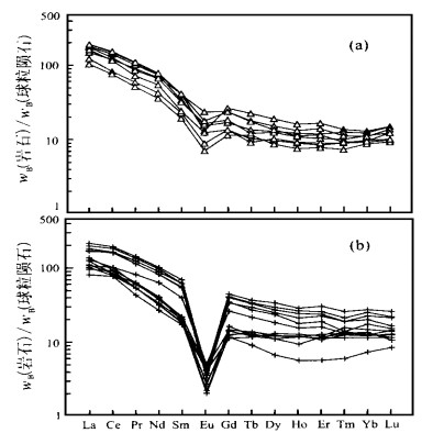
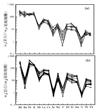
Widely exposed in Daxing'anling region are Late Jurassic and Early Cretaceous rhyolites that are classified as two major types in terms of petrology and trace-element geochemistry: Type-I rhyolite and Type-II rhyolite. The following conclusions can be drawn from the results in rare earth and trace elements:(1)Type-I rhyolite is characterized by the right-sloped REE distribution pattern. The incompatible elements in this type are featured by both the strong enrichment of Rb, Ba, Th, and K and the depletion of Sr, Ti, P, Nb. These features are related to the crystal differentiation of the calc-alkaline basaltic magma.(2)Type-II rhyolite is characterized by the REE and incompatible-element distribution pattern. The strong depletion of Ba and Sr in this type, a distinctive feature from Type-I rhyolite, established a bimodal volcanic association with alkaline basalts, whose origins are associated with the non-ideal melting of crustal rock. In addition, the formation of these two typesof rhyolitesis related to the extension of overlying lithosphere resulting from the upwelling of mantle-plume.
Widely exposed in Daxing'anling region are Late Jurassic and Early Cretaceous rhyolites that are classified as two major types in terms of petrology and trace-element geochemistry: Type-I rhyolite and Type-II rhyolite. The following conclusions can be drawn from the results in rare earth and trace elements:(1)Type-I rhyolite is characterized by the right-sloped REE distribution pattern. The incompatible elements in this type are featured by both the strong enrichment of Rb, Ba, Th, and K and the depletion of Sr, Ti, P, Nb. These features are related to the crystal differentiation of the calc-alkaline basaltic magma.(2)Type-II rhyolite is characterized by the REE and incompatible-element distribution pattern. The strong depletion of Ba and Sr in this type, a distinctive feature from Type-I rhyolite, established a bimodal volcanic association with alkaline basalts, whose origins are associated with the non-ideal melting of crustal rock. In addition, the formation of these two typesof rhyolitesis related to the extension of overlying lithosphere resulting from the upwelling of mantle-plume.
2000, 25(2): 179-185.
Abstract:
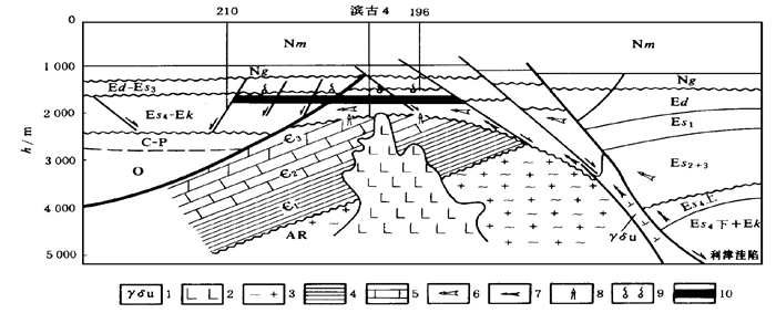
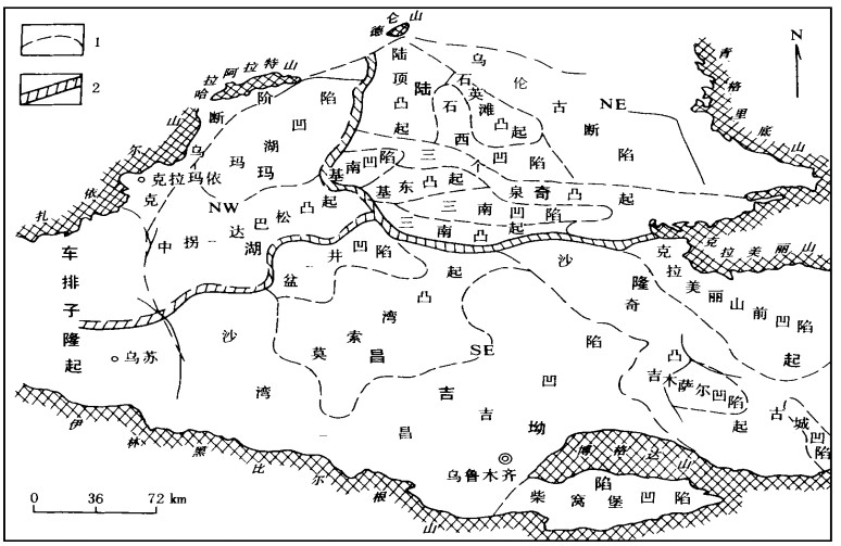
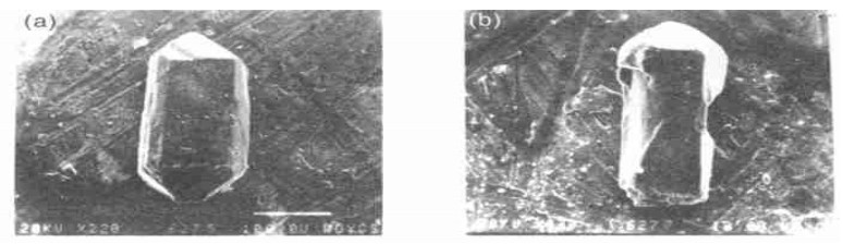
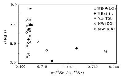
The basement of Junggar basin in the shape of triangle, interspersed in the Tarim plate, Siberia plate and Kazakhstan plate, is the key to initiating the dispute on the Xinjiang geological evolution. The igneous rocks of basement act as the role of "igneous probe". On the basis of the research into the detailed lithofacies, major elements and trace elements, the age dating research results of Sr-d isotope and zircon grain of the igneous rocks in different regions, together with the comprehensive results in Palaeozoic tectonic history, palaeontology, sedimentary formation, igneous rocks, intrusive rocks in the orogenic zone around the basin, indicate that the Junggar basement may have been a product of the soft collision and matching in tectonics between island arc systems located in the periphery of rigid bodies of the Kazakhstan plate, Tarim plates (?) and Siberia plate that occurred in different stages of the Paleozoic and subsequently experienced Mesozoic modification by tectonic-agmatic thermal events (such as the basic magmatic basal erosion).
The basement of Junggar basin in the shape of triangle, interspersed in the Tarim plate, Siberia plate and Kazakhstan plate, is the key to initiating the dispute on the Xinjiang geological evolution. The igneous rocks of basement act as the role of "igneous probe". On the basis of the research into the detailed lithofacies, major elements and trace elements, the age dating research results of Sr-d isotope and zircon grain of the igneous rocks in different regions, together with the comprehensive results in Palaeozoic tectonic history, palaeontology, sedimentary formation, igneous rocks, intrusive rocks in the orogenic zone around the basin, indicate that the Junggar basement may have been a product of the soft collision and matching in tectonics between island arc systems located in the periphery of rigid bodies of the Kazakhstan plate, Tarim plates (?) and Siberia plate that occurred in different stages of the Paleozoic and subsequently experienced Mesozoic modification by tectonic-agmatic thermal events (such as the basic magmatic basal erosion).
2000, 25(2): 186-190.
Abstract:
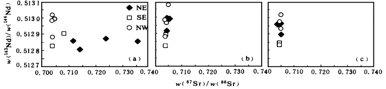
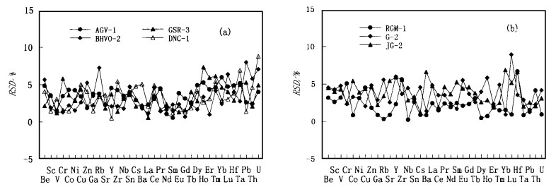
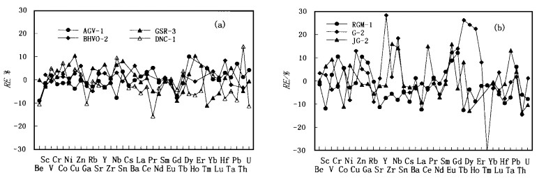
The analytical method of major, trace and ultra-trace elements is applied to geological samples using ICP-MS. In order to minimize matrix effects of inter-elements, the matrix-matched calibration solutions were prepared, simulating the composition of natural rocksobtained from statistically-calculated average values of 20 geological samples. The resulting values are then normalized. Two separate internal standards of 115 In-103Rh are selected to compensate the drift of analytical signals. Polyatomic ion interference is calibrated by measuring the oxides(MO+)and hydroxides(MOH+)with individual element solution for the ratio of MO+/M+ and MOH+/M+ and the concentrations are then equivalently calculated. The proposed method is applied to the analysis of seven standard reference materials. For the most trace elements, the relative errors between this work and the recommend values are greater than 10% and the relative standard deviations are greater than 5%.
The analytical method of major, trace and ultra-trace elements is applied to geological samples using ICP-MS. In order to minimize matrix effects of inter-elements, the matrix-matched calibration solutions were prepared, simulating the composition of natural rocksobtained from statistically-calculated average values of 20 geological samples. The resulting values are then normalized. Two separate internal standards of 115 In-103Rh are selected to compensate the drift of analytical signals. Polyatomic ion interference is calibrated by measuring the oxides(MO+)and hydroxides(MOH+)with individual element solution for the ratio of MO+/M+ and MOH+/M+ and the concentrations are then equivalently calculated. The proposed method is applied to the analysis of seven standard reference materials. For the most trace elements, the relative errors between this work and the recommend values are greater than 10% and the relative standard deviations are greater than 5%.
2000, 25(2): 191-194.
Abstract:
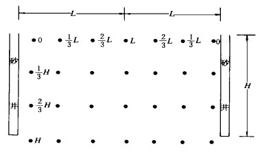
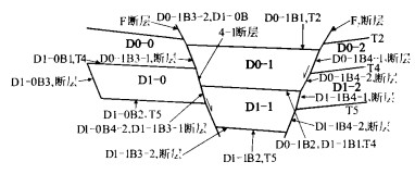
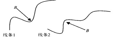
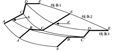
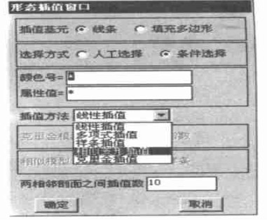
Establishing 3-D tectonic-stratigraphic basin framework is one of the key techniques in the 3-D basin modeling. Effective interpolation and extrapolation methods must be chosen to convert a series of 2-D seismic interpretation profiles into 3-D tectonic-stratigraphic basin framework. However, the selection of interpolation method and realization of spatial analyses depend on the spatial topological structure. In line with the B-Rep model-based 3-D spatial topological basin structure and the corresponding coding graphical principle, several kinds of morphological interpolation methods are introduced in this paper for the reconstruction of 3-D tectonic-stratigraphic basin framework: linear interpolation, polynomial interpolation, Kriging interpolation and spline interpolation. At the same time, the similarity deformation interpolation method is also proposed. All these methods, once successfully applied to the simulation of the 3-D tectonic-stratigraphic basin framework in Zhusan basin, may well support various spatial analyses such as vector shear analysis.
Establishing 3-D tectonic-stratigraphic basin framework is one of the key techniques in the 3-D basin modeling. Effective interpolation and extrapolation methods must be chosen to convert a series of 2-D seismic interpretation profiles into 3-D tectonic-stratigraphic basin framework. However, the selection of interpolation method and realization of spatial analyses depend on the spatial topological structure. In line with the B-Rep model-based 3-D spatial topological basin structure and the corresponding coding graphical principle, several kinds of morphological interpolation methods are introduced in this paper for the reconstruction of 3-D tectonic-stratigraphic basin framework: linear interpolation, polynomial interpolation, Kriging interpolation and spline interpolation. At the same time, the similarity deformation interpolation method is also proposed. All these methods, once successfully applied to the simulation of the 3-D tectonic-stratigraphic basin framework in Zhusan basin, may well support various spatial analyses such as vector shear analysis.
2000, 25(2): 195-200.
Abstract:
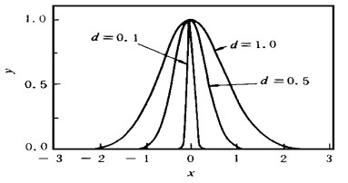
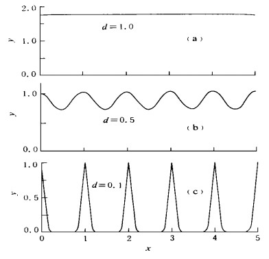
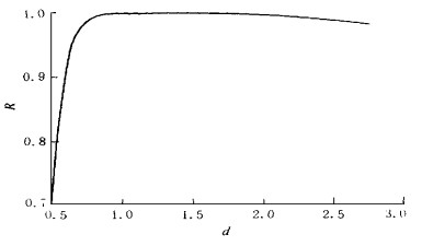
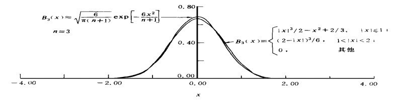
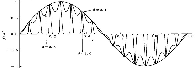
The analytical interpretation to Kriging estimation and the algebraic determination of a covariance function's parameter are presented. This paper first introduces the concept of function approximation using a rotating surface as a basic function. Then it is demonstrated that the universal Kriging may be expressed as the traditional weighted least square fitting and as the function approximation with a rotating surface as a basic function. It is also demonstrated that the parameter of a covariance function (i.e. a rotating surface) can be determined by the mathematical analysis on a certain condition (i.e. a highly continuous lump goldree effect in a random field). Finally, this paper presents two principles for the determination of a covariance function's parameter with the Gaussian function as an example: one is formulated through analysis of the linear combinations of the shifted Gaussian functions, and the other is derived from the equivalence between Bplines and Gaussian functions.
The analytical interpretation to Kriging estimation and the algebraic determination of a covariance function's parameter are presented. This paper first introduces the concept of function approximation using a rotating surface as a basic function. Then it is demonstrated that the universal Kriging may be expressed as the traditional weighted least square fitting and as the function approximation with a rotating surface as a basic function. It is also demonstrated that the parameter of a covariance function (i.e. a rotating surface) can be determined by the mathematical analysis on a certain condition (i.e. a highly continuous lump goldree effect in a random field). Finally, this paper presents two principles for the determination of a covariance function's parameter with the Gaussian function as an example: one is formulated through analysis of the linear combinations of the shifted Gaussian functions, and the other is derived from the equivalence between Bplines and Gaussian functions.
2000, 25(2): 201-204.
Abstract:
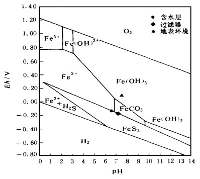
The groundwater quality parameters determined both at the well head and in the laboratory of Qijia water supply base, Daqing city, differ from what happens in the real situation. Hydrogeochemical method is used to simulate the changes of pH and Eh values due to the inevitable degassing of CO2 and H2S resulting from the pressure drop in the course of the groundwater pumping from the water-earing bed to the earth surface. The trends in the groundwater sampling are proposed in the final part of the paper.
The groundwater quality parameters determined both at the well head and in the laboratory of Qijia water supply base, Daqing city, differ from what happens in the real situation. Hydrogeochemical method is used to simulate the changes of pH and Eh values due to the inevitable degassing of CO2 and H2S resulting from the pressure drop in the course of the groundwater pumping from the water-earing bed to the earth surface. The trends in the groundwater sampling are proposed in the final part of the paper.
2000, 25(2): 205-208.
Abstract:
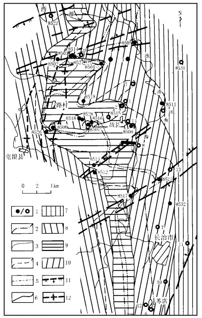
In an integrated hydrogeological unit, the mineral dissoution and precipitation occur usually in the following order: calcite, dolomite, gypsum from the recharge region to the outflow zone. Thus, the calcite saturation index in the water should often be greater than that of dolomite. However, the opposite case is present in 8508-8516 bore belt of the Lu'an mine, Xin'an springs where the saturation index of dolomite is distinctively greater than that of calcite. To explain this phenomenon, a set of hydrochemical reaction models are established in this paper and the corresponding existence conditions of these models are expounded. Furthermore, the model thus established is further tested with such theories as redox and ion alternation. Consequently, this model proves effective in the field work. Finally, this model may also prove effective in other similar hydrogeological units. Therefore, this model is universal to some extent.
In an integrated hydrogeological unit, the mineral dissoution and precipitation occur usually in the following order: calcite, dolomite, gypsum from the recharge region to the outflow zone. Thus, the calcite saturation index in the water should often be greater than that of dolomite. However, the opposite case is present in 8508-8516 bore belt of the Lu'an mine, Xin'an springs where the saturation index of dolomite is distinctively greater than that of calcite. To explain this phenomenon, a set of hydrochemical reaction models are established in this paper and the corresponding existence conditions of these models are expounded. Furthermore, the model thus established is further tested with such theories as redox and ion alternation. Consequently, this model proves effective in the field work. Finally, this model may also prove effective in other similar hydrogeological units. Therefore, this model is universal to some extent.

2000, 25(2): 209-214.
Abstract:
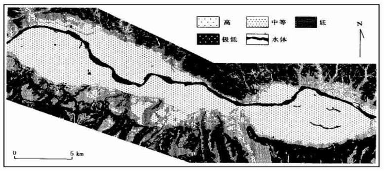
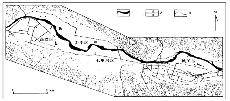
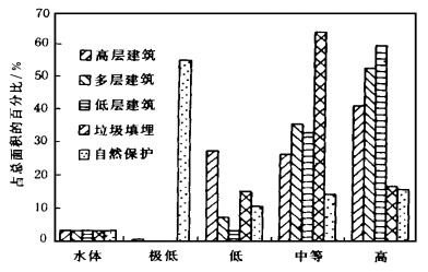
The urban geo-environmental assessment is a basic prerequisite for the urban planning and site selection. In this paper, the urban geo-environmental basic database including topography, surface and bedrock geology, depth to groundwater table and corrosion potential, lithology of bearing layer, and historic geo-hazards is established, with the Lanzhou city in northwestern China as an example, on the GIS-based ARC/ INFO development platform. The urban land use is categorized as high-rise building, multi-story building, low-rise building, solid waste disposal, and natural conservation. The index system is systematically analyzed for the assessment of the coordination between various land uses and geo-environmental potential. Then the analytic hierarchy process method isemployed to establish the evaluation model for different land uses, and geo-environment potential foreach urban land use category isevaluated. The analytical resultsindicate that the combination of the GIS technology with the quantitative evaluation model can be applied to the fast and accurate assessment of the coordination between land uses for urban construction and geo-environment potential.
The urban geo-environmental assessment is a basic prerequisite for the urban planning and site selection. In this paper, the urban geo-environmental basic database including topography, surface and bedrock geology, depth to groundwater table and corrosion potential, lithology of bearing layer, and historic geo-hazards is established, with the Lanzhou city in northwestern China as an example, on the GIS-based ARC/ INFO development platform. The urban land use is categorized as high-rise building, multi-story building, low-rise building, solid waste disposal, and natural conservation. The index system is systematically analyzed for the assessment of the coordination between various land uses and geo-environmental potential. Then the analytic hierarchy process method isemployed to establish the evaluation model for different land uses, and geo-environment potential foreach urban land use category isevaluated. The analytical resultsindicate that the combination of the GIS technology with the quantitative evaluation model can be applied to the fast and accurate assessment of the coordination between land uses for urban construction and geo-environment potential.
2000, 25(2): 215-220.
Abstract:
The research into soil microstructure is one of the frontal topics in the soil mass research. Such complex features as discontinuity, heterogeneity, anisotropy and uncertainty characteristics of the engineering soil mass on a macroscopic scale depend greatly on the discontinuity and uncertainty of the soil mass microstructure. In another word, the soil mass complexity is the direct actualization of the non-inearity of the soil mass microstructure and components. Therefore, the research into the soil mass microstructure and model has turned into one of the key issues. In this sense, the scientific establishment of the structural control model of the soil mass evolution, that of the soil-ass microstructural evolutionary mechanism-ased soil mechanic model and the constitutive relationship are new trends of the soil mechanic theoretical development. In this paper, the progresses in the soil microstructure are first presented. The characteristics are then discussed of the soil mass microstructural evolutionary mechanism and microstructural model. Finally, a new approach is proposed to the soil mechanic theoretical modeling.
The research into soil microstructure is one of the frontal topics in the soil mass research. Such complex features as discontinuity, heterogeneity, anisotropy and uncertainty characteristics of the engineering soil mass on a macroscopic scale depend greatly on the discontinuity and uncertainty of the soil mass microstructure. In another word, the soil mass complexity is the direct actualization of the non-inearity of the soil mass microstructure and components. Therefore, the research into the soil mass microstructure and model has turned into one of the key issues. In this sense, the scientific establishment of the structural control model of the soil mass evolution, that of the soil-ass microstructural evolutionary mechanism-ased soil mechanic model and the constitutive relationship are new trends of the soil mechanic theoretical development. In this paper, the progresses in the soil microstructure are first presented. The characteristics are then discussed of the soil mass microstructural evolutionary mechanism and microstructural model. Finally, a new approach is proposed to the soil mechanic theoretical modeling.