2001 Vol. 26, No. 1
Display Method:
2001, 26(1): 1-6.
 PDF 966KB
Abstract:
The Hoh Xil basin, the largest Tertiary sedimentary basin in the hinterland of the Qingzang plateau between the Kunlun Mountain and the Tanggula Mountain, may be significant for the research into the early uplift and the crustal shortening of the plateau. The 5 452.8 m-thick Eocene-Early Oligocene Fenghuoshan and Yaxicuo groups preserved in the basin consist mainly of clastic rocks and mudstone. The analysis of the clastic-rock provenance shows that the Fenghuoshan Group originated mainly from the Permian-Triassic strata in the Tanggula orogenic zone in the south, and that the Yaxicuo Group originated mainly from the Carboniferous-Permian strata in the Tanggula, Bairizhajia, and Heishishan-Gaoshan orogenic zones in the south. These sedimentary evolutionary process results from the persistent strengthening of the Paleogene tectonic uplift of the orogenic zone in the southern Hoh Xil basin, indicating that the north of the Qingzang plateau had already been uplifted to a certain height in the sedimentary period of the Yaxicuo Group.
The Hoh Xil basin, the largest Tertiary sedimentary basin in the hinterland of the Qingzang plateau between the Kunlun Mountain and the Tanggula Mountain, may be significant for the research into the early uplift and the crustal shortening of the plateau. The 5 452.8 m-thick Eocene-Early Oligocene Fenghuoshan and Yaxicuo groups preserved in the basin consist mainly of clastic rocks and mudstone. The analysis of the clastic-rock provenance shows that the Fenghuoshan Group originated mainly from the Permian-Triassic strata in the Tanggula orogenic zone in the south, and that the Yaxicuo Group originated mainly from the Carboniferous-Permian strata in the Tanggula, Bairizhajia, and Heishishan-Gaoshan orogenic zones in the south. These sedimentary evolutionary process results from the persistent strengthening of the Paleogene tectonic uplift of the orogenic zone in the southern Hoh Xil basin, indicating that the north of the Qingzang plateau had already been uplifted to a certain height in the sedimentary period of the Yaxicuo Group.


2001, 26(1): 7-12.
Abstract:
The equilibrium temperature of the mantle-derived spinel lherzolite xenolith in the basalt in Pingnan County, Guangxi lies between 930 and 980 ℃, and its corresponding equilibrium depth between 59 and 74 km. The kink-band sliding system of the olivine in the mantle-derived xenolith is often (010) [100], but sometimes (001) [100]. However, the kink-band sliding system of orthopyroxene is (100) [001]. All these sliding systems occurred both at the high temperature and at the low strain rate, indicating that the upper mantle of the region experienced the plastic deformation both at the high temperature and at the low strain rate. Varieties of dislocations are present in the olivine, such as free dislocation, dislocation wall, dislocation bow, tangle, and (110) sliding system, indicating the plastic deformation features of the upper mantle. The size of the dislocation is used to estimate the following features of the upper mantle: the differential flow stress 24.5-42.1 MPa, the flow rate 2.93×10⁻¹⁷ -8.36×10⁻¹⁶s-1, the effective viscosity η 1.72×10²³-2.80×1024 Pa·s. All these upper-mantle features are in agreement with those in the Cenozoic eastern China, showing that they both occurred in the same tensile environment.
The equilibrium temperature of the mantle-derived spinel lherzolite xenolith in the basalt in Pingnan County, Guangxi lies between 930 and 980 ℃, and its corresponding equilibrium depth between 59 and 74 km. The kink-band sliding system of the olivine in the mantle-derived xenolith is often (010) [100], but sometimes (001) [100]. However, the kink-band sliding system of orthopyroxene is (100) [001]. All these sliding systems occurred both at the high temperature and at the low strain rate, indicating that the upper mantle of the region experienced the plastic deformation both at the high temperature and at the low strain rate. Varieties of dislocations are present in the olivine, such as free dislocation, dislocation wall, dislocation bow, tangle, and (110) sliding system, indicating the plastic deformation features of the upper mantle. The size of the dislocation is used to estimate the following features of the upper mantle: the differential flow stress 24.5-42.1 MPa, the flow rate 2.93×10⁻¹⁷ -8.36×10⁻¹⁶s-1, the effective viscosity η 1.72×10²³-2.80×1024 Pa·s. All these upper-mantle features are in agreement with those in the Cenozoic eastern China, showing that they both occurred in the same tensile environment.


2001, 26(1): 13-17.
Abstract:
The calculation in the hydrostatic pressure gradient shows that the eclogites were formed in the depth of at least 70 km, and the coesite-bearing eclogites in the depth of at least 120 km. In addition, the eclogites containing both the diamond and coesite in the depth of at least 145 km. It is unimaginable that the ultrahigh-pressure metamorphic rocks are uplifted to the earth surface from such depths. Many references show that the water is indispensable to the ultrahigh-pressure metamorphism. Based on the studies of the mineral dehydration, the geothermal curves and the phase change diagram of water, this paper indicates that such supercharges as the phase transformation booster in water greatly increase the lithostatic gradient in the process of the ultrahigh-pressure metamorphism. The depth for the formation of the ultrahigh-pressure metamorphic rocks calculated with hydrostatic pressure is only the greatest depth. However, the actual depth for the formation of the ultrahigh-pressure metamorphic rocks was much smaller than the theoretical depth as calculated with hydrostatic pressure.
The calculation in the hydrostatic pressure gradient shows that the eclogites were formed in the depth of at least 70 km, and the coesite-bearing eclogites in the depth of at least 120 km. In addition, the eclogites containing both the diamond and coesite in the depth of at least 145 km. It is unimaginable that the ultrahigh-pressure metamorphic rocks are uplifted to the earth surface from such depths. Many references show that the water is indispensable to the ultrahigh-pressure metamorphism. Based on the studies of the mineral dehydration, the geothermal curves and the phase change diagram of water, this paper indicates that such supercharges as the phase transformation booster in water greatly increase the lithostatic gradient in the process of the ultrahigh-pressure metamorphism. The depth for the formation of the ultrahigh-pressure metamorphic rocks calculated with hydrostatic pressure is only the greatest depth. However, the actual depth for the formation of the ultrahigh-pressure metamorphic rocks was much smaller than the theoretical depth as calculated with hydrostatic pressure.

2001, 26(1): 18-24.
Abstract:
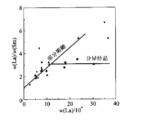
Major and trace element compositions and isotopic compositions for Taoyuan intrusion and Huanggang intrusive complex are presented in this paper. The geochemical research into the Taoyuan intrusion and Huanggang intrusive complex in the Caledonian stage, north of Tongbai shows that the Taoyuan granitic magma derived from the depleted mantle are similar to the Erlangping basic volcanic magma. The Taoyuan granites that occurred in the back-arc basin related to the subdcution of the ocean plate originated from the same magma as those of Erlangping basic volcanic rocks. The Huanggang intrusive complex, closely related to the northward subduction of the Erlangping back-arc basin, was formed in the island-arc tectonic environment. The magmas of Huanggang are mixed with a certain percentage of continental crustal substances, products of the partial melting of the mantle wedge enhanced by the fluid extracted from the subducted slab and the overlying crustal substance in the subduction process.
Major and trace element compositions and isotopic compositions for Taoyuan intrusion and Huanggang intrusive complex are presented in this paper. The geochemical research into the Taoyuan intrusion and Huanggang intrusive complex in the Caledonian stage, north of Tongbai shows that the Taoyuan granitic magma derived from the depleted mantle are similar to the Erlangping basic volcanic magma. The Taoyuan granites that occurred in the back-arc basin related to the subdcution of the ocean plate originated from the same magma as those of Erlangping basic volcanic rocks. The Huanggang intrusive complex, closely related to the northward subduction of the Erlangping back-arc basin, was formed in the island-arc tectonic environment. The magmas of Huanggang are mixed with a certain percentage of continental crustal substances, products of the partial melting of the mantle wedge enhanced by the fluid extracted from the subducted slab and the overlying crustal substance in the subduction process.


2001, 26(1): 25-32.
Abstract:
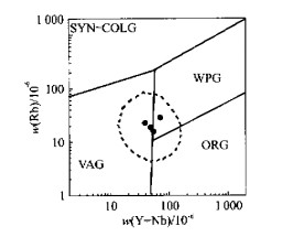
When using major and trace elements as a tool to trace tectonic settings, origins and magma sources of volcanic rocks, we must firstly reconstruct the elements on the bases of macro-regional geology and geochemical investigations, and of various kinds of rock-type assemblages in different geological bodies that occurred at that time. This reconstruction serves as the basis for the identification of the macro-tectonic settings. Secondly, we should adopt the research method characterized by the combination of the multiple geochemical information tracing with the temporal-spatial matching of various kinds of rock types, due to the temporal-spatial complexity of the tectonic settings. Thirdly, we should fully understand the application premises, ranges and conditions, so as to identify correctly the corresponding illustrations. On the basis of the three points mentioned above, this paper focuses on the multiple geochemical tracing of the two types of intermediate-basic volcanic rocks in Xiaruo-Tuoding areas in the Jinsha River combination zone, Northwest of Yunnan Province, China. This research has already brought us the following three relatively excellent effects: (1) The basic volcanic rocks located on the eastern side of the Jingsha River ophiolitic mélange zone occurred in the continental-rift setting. However, the intermediate-basic volcanic rocks are characterized by the island-arc volcanic rocks on the western side of Jingsha River ophiolitic mélange zone. (2) The volcanic lava of the two types of volcanic rocks both originated from the lava-enriched earth mantle. Specifically, the volcanic rock on the eastern side originated from the homogeneous lava-enriched earth mantle, while those on the eastern side originated from the heterogeneous lava-enriched earth mantle. (3) Finally, the structural evolutionary characteristics of these volcanic rocks are discussed.
When using major and trace elements as a tool to trace tectonic settings, origins and magma sources of volcanic rocks, we must firstly reconstruct the elements on the bases of macro-regional geology and geochemical investigations, and of various kinds of rock-type assemblages in different geological bodies that occurred at that time. This reconstruction serves as the basis for the identification of the macro-tectonic settings. Secondly, we should adopt the research method characterized by the combination of the multiple geochemical information tracing with the temporal-spatial matching of various kinds of rock types, due to the temporal-spatial complexity of the tectonic settings. Thirdly, we should fully understand the application premises, ranges and conditions, so as to identify correctly the corresponding illustrations. On the basis of the three points mentioned above, this paper focuses on the multiple geochemical tracing of the two types of intermediate-basic volcanic rocks in Xiaruo-Tuoding areas in the Jinsha River combination zone, Northwest of Yunnan Province, China. This research has already brought us the following three relatively excellent effects: (1) The basic volcanic rocks located on the eastern side of the Jingsha River ophiolitic mélange zone occurred in the continental-rift setting. However, the intermediate-basic volcanic rocks are characterized by the island-arc volcanic rocks on the western side of Jingsha River ophiolitic mélange zone. (2) The volcanic lava of the two types of volcanic rocks both originated from the lava-enriched earth mantle. Specifically, the volcanic rock on the eastern side originated from the homogeneous lava-enriched earth mantle, while those on the eastern side originated from the heterogeneous lava-enriched earth mantle. (3) Finally, the structural evolutionary characteristics of these volcanic rocks are discussed.


2001, 26(1): 33-39.
Abstract:
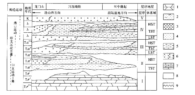
This paper analyses the foreland basin-mountain coupling from the stratigraphy in the foreland basin. The research areas include the Sichuan Mesozoic foreland basin and Erdos Mesozoic foreland basin in the central part of China. The research shows that the foreland basin is relatively well coupled with the orogenic belt. The filling sediment features of the foreland basin mirror the formation and evolution of the orogenic belts and the subsidence of the foreland basin. The migration of the upward-coarsening sedimentary succession and the stratigraphic unconformity toward the direction of the foreland basin reflects the evolutionary process of the consecutive uplift of the orogenic belt toward the foreland. The lithological feature of the sediments in the foreland basin reflects the double-source supply and the orogenic-belt erosion. The structure of the system tracts in the sequence stratigraphy and the stratigraphic accumulation pattern are mainly controlled by the change in the subsidence rate of the foreland basin.
This paper analyses the foreland basin-mountain coupling from the stratigraphy in the foreland basin. The research areas include the Sichuan Mesozoic foreland basin and Erdos Mesozoic foreland basin in the central part of China. The research shows that the foreland basin is relatively well coupled with the orogenic belt. The filling sediment features of the foreland basin mirror the formation and evolution of the orogenic belts and the subsidence of the foreland basin. The migration of the upward-coarsening sedimentary succession and the stratigraphic unconformity toward the direction of the foreland basin reflects the evolutionary process of the consecutive uplift of the orogenic belt toward the foreland. The lithological feature of the sediments in the foreland basin reflects the double-source supply and the orogenic-belt erosion. The structure of the system tracts in the sequence stratigraphy and the stratigraphic accumulation pattern are mainly controlled by the change in the subsidence rate of the foreland basin.


2001, 26(1): 41-48.
Abstract:
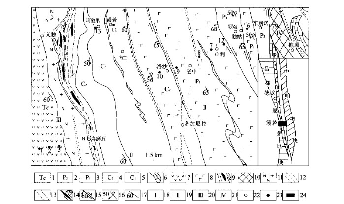
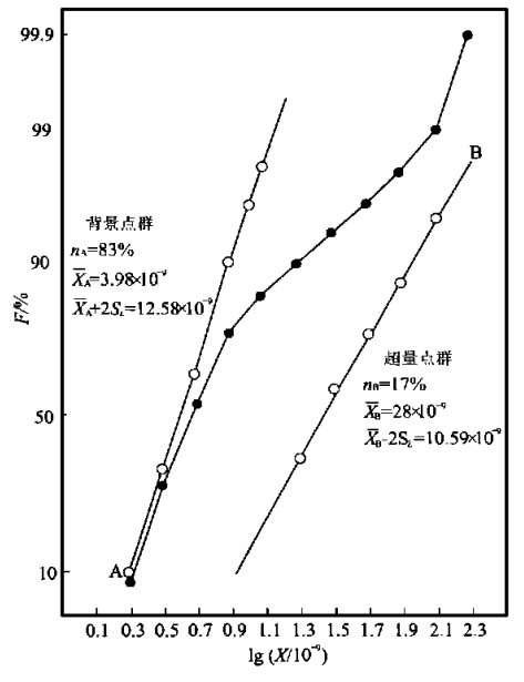
This paper addresses the possible source, evolution and accumulation patterns of the ore-forming compositions, on the basis of the geological research, the statistical analysis, and the research into the Archean strata, the Mesozoic intrusive complexes and the chemical composition of gold deposits in different ages in the western Shandong uplift terrain. Then this paper suggests the concept of and the quantitative calculation method for the ore-forming activity of the elements in the mineralized source beds (rocks). The research shows the following three points: (1) In the western Shandong uplift terrain, the initial source of the gold is the Archean greenstone belts characterized by the bimodal gold distribution. (2) A conspicuous inheritance can be observed on the ore-bearing formation in terms of the mineralized compositions of different kinds of gold deposits despite of the different ages and different mineralizations from the Archean to the Mesozoic. (3) The characteristics of epigenetic hydrothermal deposits are determined to a great extent by the ratio between the excessive population of mineralized elements and its corresponding background population in the ore-bearing formation, and also by the average content of mineralized elements in the excessive population.
This paper addresses the possible source, evolution and accumulation patterns of the ore-forming compositions, on the basis of the geological research, the statistical analysis, and the research into the Archean strata, the Mesozoic intrusive complexes and the chemical composition of gold deposits in different ages in the western Shandong uplift terrain. Then this paper suggests the concept of and the quantitative calculation method for the ore-forming activity of the elements in the mineralized source beds (rocks). The research shows the following three points: (1) In the western Shandong uplift terrain, the initial source of the gold is the Archean greenstone belts characterized by the bimodal gold distribution. (2) A conspicuous inheritance can be observed on the ore-bearing formation in terms of the mineralized compositions of different kinds of gold deposits despite of the different ages and different mineralizations from the Archean to the Mesozoic. (3) The characteristics of epigenetic hydrothermal deposits are determined to a great extent by the ratio between the excessive population of mineralized elements and its corresponding background population in the ore-bearing formation, and also by the average content of mineralized elements in the excessive population.


2001, 26(1): 49-53.
Abstract:
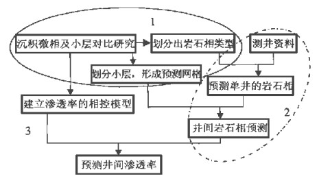
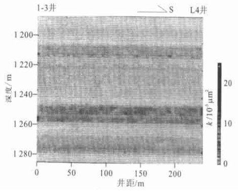
The spatial distribution of the physical parameters in the reservoir has for a long time been a difficulty in the research into the reservoir heterogeneity. Both the fractal and Monto Carlo methods and the correlation between the fine sedimentary micro-facies and the sublayers are used to forecast the lithofacies distribution between wells. In addition, the core data are employed to establish the lithofacies-controlled models on the permeabilities for various kinds of lithofacies. Therefore, the permeabilities between wells can be forecasted. This method established on the geological features, combines the geological data with the mathematical methods, so as to fully reflect the continuity of the permeabilities between wells and the very violent changes in the permeabilities. In this sense, this method may serve as a new perspective for the spatial forecast of the physical parameters between wells.
The spatial distribution of the physical parameters in the reservoir has for a long time been a difficulty in the research into the reservoir heterogeneity. Both the fractal and Monto Carlo methods and the correlation between the fine sedimentary micro-facies and the sublayers are used to forecast the lithofacies distribution between wells. In addition, the core data are employed to establish the lithofacies-controlled models on the permeabilities for various kinds of lithofacies. Therefore, the permeabilities between wells can be forecasted. This method established on the geological features, combines the geological data with the mathematical methods, so as to fully reflect the continuity of the permeabilities between wells and the very violent changes in the permeabilities. In this sense, this method may serve as a new perspective for the spatial forecast of the physical parameters between wells.


2001, 26(1): 54-58.
Abstract:
Three kinds of structural patterns present on the northern margin of the Qaidam basin in the Mesozoic and Cenozoic are shown in this paper as follows: the extensional structure, the torsional structure, and the thrust-fold structure. The structural pattern of the normal fault assemblage that occurred in the Early and Middle Jurassic may have initiated some small-scale petroleum and gas pools. The compressive torsional structure that occurred in the Early Tertiary may have controlled the accumulation of petroleum and gas. However, the petroleum and gas-bearing properties vary greatly in the thrust-fold structure that occurred in the Late Tertiary-Quaternary. The thrust-fold structure that have developed from the early fault is favorable for the distribution of petroleum and gas. On the other side, the newly-formed thrust-fold structure is usually not favorable for the accumulation of petroleum and gas. The structural stress has an important effect on the migration and accumulation of petroleum and gas. The stress caused by the change in the structural stress rate is the main driving force for the vertical migration of the petroleum and gas along the fault. Near the fault, the stress value is moderately medium, the lithological dilation is relatively great, and the micro-cracks develop well. Such a region is favorable for the accumulation of petroleum and gas.
Three kinds of structural patterns present on the northern margin of the Qaidam basin in the Mesozoic and Cenozoic are shown in this paper as follows: the extensional structure, the torsional structure, and the thrust-fold structure. The structural pattern of the normal fault assemblage that occurred in the Early and Middle Jurassic may have initiated some small-scale petroleum and gas pools. The compressive torsional structure that occurred in the Early Tertiary may have controlled the accumulation of petroleum and gas. However, the petroleum and gas-bearing properties vary greatly in the thrust-fold structure that occurred in the Late Tertiary-Quaternary. The thrust-fold structure that have developed from the early fault is favorable for the distribution of petroleum and gas. On the other side, the newly-formed thrust-fold structure is usually not favorable for the accumulation of petroleum and gas. The structural stress has an important effect on the migration and accumulation of petroleum and gas. The stress caused by the change in the structural stress rate is the main driving force for the vertical migration of the petroleum and gas along the fault. Near the fault, the stress value is moderately medium, the lithological dilation is relatively great, and the micro-cracks develop well. Such a region is favorable for the accumulation of petroleum and gas.


2001, 26(1): 59-66.
Abstract:
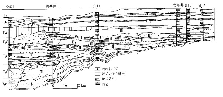
The principle of and method for the contemporary sequence stratigraphy are both employed to analyze comprehensively the references on seismology, logging, and cores. This comprehensive analysis shows that the Qiongdongnan basin may have experienced two major growth stages: the early rift stage and the late depression stage, corresponding to the two supersequence sets: Tejas A and Tejas B. In addition, five supersequences were formed that corresponded to the five evolutionary stages in the basin: nonmarine facies, marine transitional facies, growth fault, ramp, and passive continental setting. The unconformity and its counterpart, the conformity, both serving as the third-order sequence boundaries are employed to identify 19 sequences containing 57 systems tracts, over 54 parasequence sets and over 196 parasequences. The major differences between different evolutionary stages and between different sedimentary sequences in the basin are both attributed to the different sedimentary system contained in the lowstand systems tract. On the basis of the reconstruction of the paleo-environment settings, have been established the models of depositional sequences. The accomodation analysis is applied to the compilation of the sea-level change curve of the Qiongdongnan basin, resulting in the discovery of the perfect matching between the three major marine floods that occurred in the middle Lingshui, early Meishan and early Yinggehai stages, and the corresponding globe changes. The best potential hydrocarbon resources are located vertically in the section between the marine transgressive systems tract and the condensed section, but laterally between the outer-shelf to the continental slope. The next best potential hydrocarbon resources are located in the littoral-aquamarsh deposits or in the marine-continental transitional facies. This paper suggests that the lowstand wedge and the slope fan near the continental-shelf slope break should serve as the petroleum exploration target of the hidden traps worthy of attention.
The principle of and method for the contemporary sequence stratigraphy are both employed to analyze comprehensively the references on seismology, logging, and cores. This comprehensive analysis shows that the Qiongdongnan basin may have experienced two major growth stages: the early rift stage and the late depression stage, corresponding to the two supersequence sets: Tejas A and Tejas B. In addition, five supersequences were formed that corresponded to the five evolutionary stages in the basin: nonmarine facies, marine transitional facies, growth fault, ramp, and passive continental setting. The unconformity and its counterpart, the conformity, both serving as the third-order sequence boundaries are employed to identify 19 sequences containing 57 systems tracts, over 54 parasequence sets and over 196 parasequences. The major differences between different evolutionary stages and between different sedimentary sequences in the basin are both attributed to the different sedimentary system contained in the lowstand systems tract. On the basis of the reconstruction of the paleo-environment settings, have been established the models of depositional sequences. The accomodation analysis is applied to the compilation of the sea-level change curve of the Qiongdongnan basin, resulting in the discovery of the perfect matching between the three major marine floods that occurred in the middle Lingshui, early Meishan and early Yinggehai stages, and the corresponding globe changes. The best potential hydrocarbon resources are located vertically in the section between the marine transgressive systems tract and the condensed section, but laterally between the outer-shelf to the continental slope. The next best potential hydrocarbon resources are located in the littoral-aquamarsh deposits or in the marine-continental transitional facies. This paper suggests that the lowstand wedge and the slope fan near the continental-shelf slope break should serve as the petroleum exploration target of the hidden traps worthy of attention.


2001, 26(1): 67-72.
Abstract:
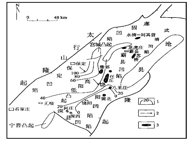
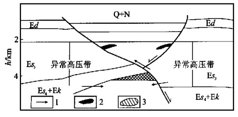
The comprehensive analysis of fluid pressure field, fluid chemical field and fluid-migrating conduits of buried hills in Jizhong depression, Bohai Bay basin classifies the buried hills as the following three major dynamic categories of petroleum migration and accumulation: (1) unconformity-connected-open buried hills (Type Ⅰ), (2) fault conduit-semi-open/semi-closed buried hills (Type Ⅱ), and (3) closed buried hills (Type Ⅲ). Type I buried hills are connected with the regional underground hydrodynamic system located in the middle part of the Jizhong depression where is present a sufficient supply of the petroleum and gas that may result in the formation of large-scale hydrocarbon pools in the buried hills. Type Ⅱ buried hills occur in the slopes close to the hydrocarbon-generated sags, with the seismic pumping conduits in the buried hill-associated faults serving as the acting force on the petroleum and gas migration and accumulation, exhibiting an excellent condition for the petroleum pools. Type Ⅲ buried hills scattered within the depression zone with a relatively great degree of subsidization occur separately and are overlapped by the Tertiary abnormally high pressure zone, restraining the acting force of the fluid conduits associated with the buried hills. In this case, the buried hills in the closed system with the relatively poor condition of petroleum and gas migration and accumulation may accommodate small-sized petroleum and gas pools of the buried hills with great exploration risks.
The comprehensive analysis of fluid pressure field, fluid chemical field and fluid-migrating conduits of buried hills in Jizhong depression, Bohai Bay basin classifies the buried hills as the following three major dynamic categories of petroleum migration and accumulation: (1) unconformity-connected-open buried hills (Type Ⅰ), (2) fault conduit-semi-open/semi-closed buried hills (Type Ⅱ), and (3) closed buried hills (Type Ⅲ). Type I buried hills are connected with the regional underground hydrodynamic system located in the middle part of the Jizhong depression where is present a sufficient supply of the petroleum and gas that may result in the formation of large-scale hydrocarbon pools in the buried hills. Type Ⅱ buried hills occur in the slopes close to the hydrocarbon-generated sags, with the seismic pumping conduits in the buried hill-associated faults serving as the acting force on the petroleum and gas migration and accumulation, exhibiting an excellent condition for the petroleum pools. Type Ⅲ buried hills scattered within the depression zone with a relatively great degree of subsidization occur separately and are overlapped by the Tertiary abnormally high pressure zone, restraining the acting force of the fluid conduits associated with the buried hills. In this case, the buried hills in the closed system with the relatively poor condition of petroleum and gas migration and accumulation may accommodate small-sized petroleum and gas pools of the buried hills with great exploration risks.


2001, 26(1): 73-77.
Abstract:
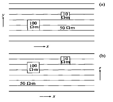
The finite element method is used for the numerical modeling of the resistivity sounding in a 3-D point-source electric field whose conductivities are homogeneous for each block. In this paper, the 3-D boundary value and variational equation concerning the point-source electrical field in the 3-D structure are both presented. Then the finite element method is used to solve the variational equation. The entire region is divided into many hexahedral units in each of which a trilinear function is interpolated. The variational equation is converted into a linear equation system. Finally the equation system is solved to obtain the potential value on each of the nodes, resulting in the calculation of the apparent resistivity on the ground surface. The test of several relatively typical geoelectric models shows that this finite element method is effective.
The finite element method is used for the numerical modeling of the resistivity sounding in a 3-D point-source electric field whose conductivities are homogeneous for each block. In this paper, the 3-D boundary value and variational equation concerning the point-source electrical field in the 3-D structure are both presented. Then the finite element method is used to solve the variational equation. The entire region is divided into many hexahedral units in each of which a trilinear function is interpolated. The variational equation is converted into a linear equation system. Finally the equation system is solved to obtain the potential value on each of the nodes, resulting in the calculation of the apparent resistivity on the ground surface. The test of several relatively typical geoelectric models shows that this finite element method is effective.


2001, 26(1): 78-82.
Abstract:
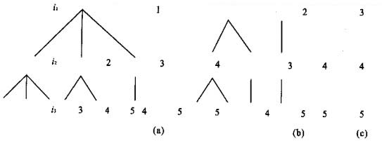
This paper presents the method, appropriate for the non-linear inversion, for the construction of the controlling chaos inversion system and the corresponding algorithm logical design of matrix-element-controlled calculation. In this method, a coupling relationship is established between the iterative inversion-controlled parameters and iterative inversion outputs. In this relationship, the controlled parameters should be updated to ensure that the iterative stability is converged to the desired solution. During the solution process, the data structure method is applied to the analysis of the data structure of the computer-controlling matrix for the controlling chaos theory. The tree structure is presented in this paper to express the subscripted sampling logic used in the calculation of the controlling matrix. Each tree is traveled through the symmetric traversal to locate the combinatorial sequence of each element. The numerical algorithm examples listed in this paper illustrate the effectiveness of controlling chaos inversion method and algorithm.
This paper presents the method, appropriate for the non-linear inversion, for the construction of the controlling chaos inversion system and the corresponding algorithm logical design of matrix-element-controlled calculation. In this method, a coupling relationship is established between the iterative inversion-controlled parameters and iterative inversion outputs. In this relationship, the controlled parameters should be updated to ensure that the iterative stability is converged to the desired solution. During the solution process, the data structure method is applied to the analysis of the data structure of the computer-controlling matrix for the controlling chaos theory. The tree structure is presented in this paper to express the subscripted sampling logic used in the calculation of the controlling matrix. Each tree is traveled through the symmetric traversal to locate the combinatorial sequence of each element. The numerical algorithm examples listed in this paper illustrate the effectiveness of controlling chaos inversion method and algorithm.


2001, 26(1): 83-87.
Abstract:
The PAHs, widely distributed in our environment, and harmful to our health, is a kind of organic compounds. The analysis of the natural geography in the Dinghushan natural protection zone and that of the benzopyrene in aerosols conclude that the content of PAHs in aerosols in the spring samples comes mainly from the emission from the plants. However that in the summer samples comes mainly from the discharge of the fossil burning in the Pearl River Delta Economic Zone.
The PAHs, widely distributed in our environment, and harmful to our health, is a kind of organic compounds. The analysis of the natural geography in the Dinghushan natural protection zone and that of the benzopyrene in aerosols conclude that the content of PAHs in aerosols in the spring samples comes mainly from the emission from the plants. However that in the summer samples comes mainly from the discharge of the fossil burning in the Pearl River Delta Economic Zone.


2001, 26(1): 88-92.
Abstract:
Luhun Reservoir lies in the middle reaches of Yi River, Songxian County, Luoyang City, Henan Province, China. The authors have analyzed the water-level observation references for the past over 30 years, and determined the qualitative analysis of the hydrogeological models. On this basis, this paper presents, in line with the principle of modern mathematical statistics, a successful solution to the seepage in the dam foundation that has prevented the normal operation of the reservoir. This solution deepens our understanding of the seepage stability and its changing pattern for the dam foundation, in order to secure the normal operation of the dam when the reservoir reaches its normal high water levels (319.5 m, 327.5 m, 331.8 m).The research results show that the present operation of the dam is normal, that the weak parts of the cut-off trench can be consolidated during the slow storage of water in the reservoir, and that the seepage resistance rate at the interface between the soil fill and the rocks in the cut-off trench may reach over 45. The seepage-proof system consisting of the blanket in the upper reaches and the cut-off trench combined with the drainage in the lower reaches has effectively controlled the seepage in the dam foundation. At the same time, the seepage in the dam foundation when the water level is high is forecasted to be stable, so that the reservoir can be put to operation when the water level in the reservoir is high, providing an example of the proof of a defective and dangerous reservoir.
Luhun Reservoir lies in the middle reaches of Yi River, Songxian County, Luoyang City, Henan Province, China. The authors have analyzed the water-level observation references for the past over 30 years, and determined the qualitative analysis of the hydrogeological models. On this basis, this paper presents, in line with the principle of modern mathematical statistics, a successful solution to the seepage in the dam foundation that has prevented the normal operation of the reservoir. This solution deepens our understanding of the seepage stability and its changing pattern for the dam foundation, in order to secure the normal operation of the dam when the reservoir reaches its normal high water levels (319.5 m, 327.5 m, 331.8 m).The research results show that the present operation of the dam is normal, that the weak parts of the cut-off trench can be consolidated during the slow storage of water in the reservoir, and that the seepage resistance rate at the interface between the soil fill and the rocks in the cut-off trench may reach over 45. The seepage-proof system consisting of the blanket in the upper reaches and the cut-off trench combined with the drainage in the lower reaches has effectively controlled the seepage in the dam foundation. At the same time, the seepage in the dam foundation when the water level is high is forecasted to be stable, so that the reservoir can be put to operation when the water level in the reservoir is high, providing an example of the proof of a defective and dangerous reservoir.


2001, 26(1): 93-98.
Abstract:
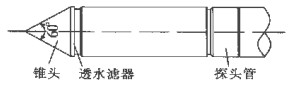
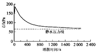
The dissipation tests of excessive pore water pressure have been conducted in the soft soil region of the Zhujiang delta in order to discuss the feasibility and principle of determining the consolidation coefficient of the soft soil by means of the piezo-cone penetration test (CPTU). In this paper, the testing sites, equipment and methods are briefly described, with an emphasis on analysis of the testing mechanism and results. Moreover, the comparison is completed of the estimation of the consolidation coefficient by means of the pore pressure dissipation test with the trial values obtained from the indoor consolidation experiment and the inverse value of the in-situ subsidence records. As a result, a very good pattern is located among these three. In addition, the consolidation coefficient determined by CPTU is more approximate to the real coefficient.
The dissipation tests of excessive pore water pressure have been conducted in the soft soil region of the Zhujiang delta in order to discuss the feasibility and principle of determining the consolidation coefficient of the soft soil by means of the piezo-cone penetration test (CPTU). In this paper, the testing sites, equipment and methods are briefly described, with an emphasis on analysis of the testing mechanism and results. Moreover, the comparison is completed of the estimation of the consolidation coefficient by means of the pore pressure dissipation test with the trial values obtained from the indoor consolidation experiment and the inverse value of the in-situ subsidence records. As a result, a very good pattern is located among these three. In addition, the consolidation coefficient determined by CPTU is more approximate to the real coefficient.


2001, 26(1): 99-104.
Abstract:
Until now there has been no perfect method for the determination of three-dimensional paleotectonic stress field. In this paper, a new method for this determination is shown in the following steps: Firstly, rock specimens are drilled in six or more different directions out of the large rock cores or fresh rock blocks in the testing site. For each direction, ten or more specimens should be obtained. Secondly, the maximum principal stresses of the main tectonic movements experienced by the rock specimens to be measured are determined by means of the "Acoustic Emission Incomplete Erase Phenomenon in the General Sense". Thirdly, the maximum principal stress value (σmt) of the highest paleotectonic stress state left in the rock specimens is obtained via statistical analysis. It has been found that the rock specimens still contain the normal stresses (σmn) induced by the highest paleotectonic stress state in different sampling directions. However, these normal stresses are hidden between the maximum main stress values induced by the relatively low paleotectonic stress states in different phases, so that they are not easy to differentiate from each other. In this paper, these hidden normal stresses σmn can be located by means of the "AE inversion searching method" with σmt as a target. Therefore, the highest paleotectonic stress state experienced by the rock specimens can be calculated. The feasibility of this new method has been confirmed by a simulation experiment in the pseudo-plane stress state.
Until now there has been no perfect method for the determination of three-dimensional paleotectonic stress field. In this paper, a new method for this determination is shown in the following steps: Firstly, rock specimens are drilled in six or more different directions out of the large rock cores or fresh rock blocks in the testing site. For each direction, ten or more specimens should be obtained. Secondly, the maximum principal stresses of the main tectonic movements experienced by the rock specimens to be measured are determined by means of the "Acoustic Emission Incomplete Erase Phenomenon in the General Sense". Thirdly, the maximum principal stress value (σmt) of the highest paleotectonic stress state left in the rock specimens is obtained via statistical analysis. It has been found that the rock specimens still contain the normal stresses (σmn) induced by the highest paleotectonic stress state in different sampling directions. However, these normal stresses are hidden between the maximum main stress values induced by the relatively low paleotectonic stress states in different phases, so that they are not easy to differentiate from each other. In this paper, these hidden normal stresses σmn can be located by means of the "AE inversion searching method" with σmt as a target. Therefore, the highest paleotectonic stress state experienced by the rock specimens can be calculated. The feasibility of this new method has been confirmed by a simulation experiment in the pseudo-plane stress state.


2001, 26(1): 105-109.
Abstract:
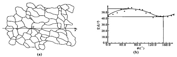
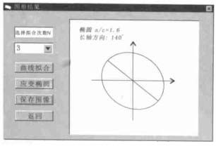
Computer simulation of finite-strain determination with the inverse SURFOR wheel may improve the preciseness and efficiency of the strain determination. The CSD softwre, programmed in Visual Basic 5.0 and very simple for its friendly interface, can be used to measure the size of the finite strain and the direction of the long axis of the finite strain ellipse in deformed rocks by means of section images or mineral grain sketches. At the same time, this software can also be used to measure the preferred orientation of the mineral grain distribution. Firstly, the CSD software collects boundaries of mineral grains in the image at all directions from 0°-180°. Secondly, the boundary data dots are distributed in the orientation-boundary coordinate system, and the polynomial curve fitting is made by means of the least-squares. Lastly, the extreme point coordinate of the fitted curve is obtained, and the corresponding strain ellipse is drawn up in line with the coordinate. During the operation of the CSD software, all the collected data of mineral grain boundaries and the resulting fitted curve, and the strain ellipse images can be both visible and saved in the corresponding files.
Computer simulation of finite-strain determination with the inverse SURFOR wheel may improve the preciseness and efficiency of the strain determination. The CSD softwre, programmed in Visual Basic 5.0 and very simple for its friendly interface, can be used to measure the size of the finite strain and the direction of the long axis of the finite strain ellipse in deformed rocks by means of section images or mineral grain sketches. At the same time, this software can also be used to measure the preferred orientation of the mineral grain distribution. Firstly, the CSD software collects boundaries of mineral grains in the image at all directions from 0°-180°. Secondly, the boundary data dots are distributed in the orientation-boundary coordinate system, and the polynomial curve fitting is made by means of the least-squares. Lastly, the extreme point coordinate of the fitted curve is obtained, and the corresponding strain ellipse is drawn up in line with the coordinate. During the operation of the CSD software, all the collected data of mineral grain boundaries and the resulting fitted curve, and the strain ellipse images can be both visible and saved in the corresponding files.