2001 Vol. 26, No. 2
Display Method:
2001, 26(2): 111-117.
 PDF 281KB
Abstract:
Diversity of mineralization is an essential phenomenon in ore-forming process. It is represented not only in genesis, morphology, attitude, dimensions, ore types, ore combination, useful and damaging elements within one deposit, but also in ore deposits, ore fields, ore belts, ore provinces, mineralized district and metallogenic epoch. It is subject to geo-anomalies of ore source in the origin of ore materials, to geo-anomalies of ore fluid in the carrier of ore medium, to geo-anomalies of ore transformation in energy, to geo-anomalies of reservoir environment in ore accumulation, and to geo-anomalies of preservation or destruction in post-metallogenic diversification. Therefore, the characteristics and attribution of diversity of mineralization may be determined by the geo-anomaly background. The spectrum of ore deposits is related genetically with the diversity of mineralization, which may play an important role in appraising and forecasting new types of mineral deposits. So the research of diversity of mineralization and its spectrum of ore deposits is of great significance in discovering regional rules of mineralization as well as research of supper-large ore deposits, ore fluid and regional mineralization on a large scale.
Diversity of mineralization is an essential phenomenon in ore-forming process. It is represented not only in genesis, morphology, attitude, dimensions, ore types, ore combination, useful and damaging elements within one deposit, but also in ore deposits, ore fields, ore belts, ore provinces, mineralized district and metallogenic epoch. It is subject to geo-anomalies of ore source in the origin of ore materials, to geo-anomalies of ore fluid in the carrier of ore medium, to geo-anomalies of ore transformation in energy, to geo-anomalies of reservoir environment in ore accumulation, and to geo-anomalies of preservation or destruction in post-metallogenic diversification. Therefore, the characteristics and attribution of diversity of mineralization may be determined by the geo-anomaly background. The spectrum of ore deposits is related genetically with the diversity of mineralization, which may play an important role in appraising and forecasting new types of mineral deposits. So the research of diversity of mineralization and its spectrum of ore deposits is of great significance in discovering regional rules of mineralization as well as research of supper-large ore deposits, ore fluid and regional mineralization on a large scale.


2001, 26(2): 118-122.
Abstract:
The north-western Sichuan Province, one of the main micro-grain disseminated gold metallogenic zone in China, possesses about twenty important gold deposits (or occurrences) such as Ma'naoke etc. Studies show that several kinds of quartz veins are often developed in the mining districts in this region, among which pyrite-arsenopyrite-quartz, quartz-stibnite as well as quartz-realgar (orpiment) veins are intimately related with gold mineralization and their spatial distribution is mainly constrained in the gold mineralization belts. While the development degree of these three kinds of quartz veins can indicate gold mineralization intensity to some extent, so they are important macroscopic marks for exploration and evaluation of this type of gold deposits in the region. Studies on fluid inclusions show that these kinds of quartz veins formed in a hydrothermal condition with temperature range from 170 ℃ to 210 ℃ and salinity of fluids range from 4% to 11%, the w(CO2) / w (H2O) value of the gaseous compositions of fluid inclusions is between 0.240 and 0.491 in general, and the relatively light density values of quartz are usually lower than 8.0. All these are obviously different from other kinds of quartz veins, so these parameters of quartz form the important microscopic marks for exploration and evaluation of gold deposits in the region.
The north-western Sichuan Province, one of the main micro-grain disseminated gold metallogenic zone in China, possesses about twenty important gold deposits (or occurrences) such as Ma'naoke etc. Studies show that several kinds of quartz veins are often developed in the mining districts in this region, among which pyrite-arsenopyrite-quartz, quartz-stibnite as well as quartz-realgar (orpiment) veins are intimately related with gold mineralization and their spatial distribution is mainly constrained in the gold mineralization belts. While the development degree of these three kinds of quartz veins can indicate gold mineralization intensity to some extent, so they are important macroscopic marks for exploration and evaluation of this type of gold deposits in the region. Studies on fluid inclusions show that these kinds of quartz veins formed in a hydrothermal condition with temperature range from 170 ℃ to 210 ℃ and salinity of fluids range from 4% to 11%, the w(CO2) / w (H2O) value of the gaseous compositions of fluid inclusions is between 0.240 and 0.491 in general, and the relatively light density values of quartz are usually lower than 8.0. All these are obviously different from other kinds of quartz veins, so these parameters of quartz form the important microscopic marks for exploration and evaluation of gold deposits in the region.


2001, 26(2): 123-128.
Abstract:
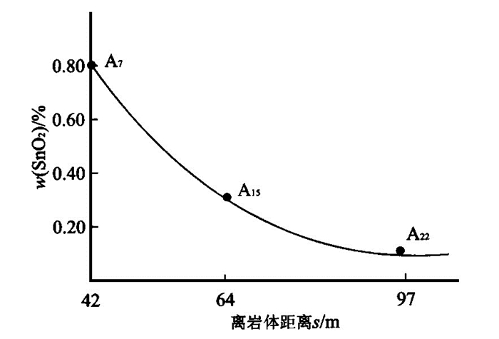
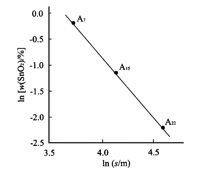
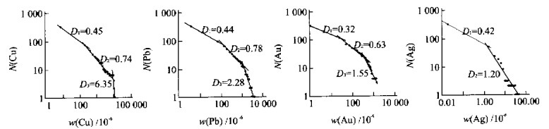
The W, Sn, Mo, Bi multi-metallic deposit in Shizhuyuan, Hunan is a very large deposit. Its mineralized system is very complex, containing multilayers and many subsystems. By micro-area chemical analysis, the distribution of Sn, W, Bi in the garnet of massive skarn is studied. It is confirmed that the contents of Sn and other elements possess the characteristics of power-rate in macro-scale and micro-scale, i.e. fraction-dimensional time-spatial structure. The fraction-dimension of Sn is 1.7 in garnet, 1.8 in vesuvianite, and 1.9 in anaphase epidote. From the micro-distribution characteristics of mineralized elements in mineral crystals, mineralized large-system was always critical, when it was disturbed, it would return to critical state by discontinuously reacting-equilibrating, this type of self building-up critical state is the fundamental dynamic characteristics of the deposit.
The W, Sn, Mo, Bi multi-metallic deposit in Shizhuyuan, Hunan is a very large deposit. Its mineralized system is very complex, containing multilayers and many subsystems. By micro-area chemical analysis, the distribution of Sn, W, Bi in the garnet of massive skarn is studied. It is confirmed that the contents of Sn and other elements possess the characteristics of power-rate in macro-scale and micro-scale, i.e. fraction-dimensional time-spatial structure. The fraction-dimension of Sn is 1.7 in garnet, 1.8 in vesuvianite, and 1.9 in anaphase epidote. From the micro-distribution characteristics of mineralized elements in mineral crystals, mineralized large-system was always critical, when it was disturbed, it would return to critical state by discontinuously reacting-equilibrating, this type of self building-up critical state is the fundamental dynamic characteristics of the deposit.


2001, 26(2): 129-134.
Abstract:
Digital pattern for mineral exploration is a powerful tool for digital mineral exploration projects. Preliminarily this paper expounds (a) the fundamental theory of the digital pattern for mineral exploration; (b) the features of geological geochemical geophysical and remote sensing information and their functions for mineral exploration; (c) the procedure for extraction connection transformation and integration of ore-finding information and (d) the methods of establishment of digital pattern for mineral exploration based on geoanomaly. In fact the process of extraction and synthesis of ore-finding information is also a process of establishing a digital pattern for mineral exploration.
Digital pattern for mineral exploration is a powerful tool for digital mineral exploration projects. Preliminarily this paper expounds (a) the fundamental theory of the digital pattern for mineral exploration; (b) the features of geological geochemical geophysical and remote sensing information and their functions for mineral exploration; (c) the procedure for extraction connection transformation and integration of ore-finding information and (d) the methods of establishment of digital pattern for mineral exploration based on geoanomaly. In fact the process of extraction and synthesis of ore-finding information is also a process of establishing a digital pattern for mineral exploration.
2001, 26(2): 135-138.
Abstract:
Hydraulic fracturing is one of the most significant deformation form within the crust. Many hydrothermal veins and ore deposits are formed through hydraulic fracturing. As a case study, this contribution integrates available geological data in an attempt to document the geometric pattern, recognizing features as well as origin of the breccia-vein system from the Jinyinzhai uranium deposit, South China. Current study demonstrates that hydraulic fracturing has exerted critical effects on hydrothemal mineralization, and that the associated breccia is a significant ore-finding indicator.
Hydraulic fracturing is one of the most significant deformation form within the crust. Many hydrothermal veins and ore deposits are formed through hydraulic fracturing. As a case study, this contribution integrates available geological data in an attempt to document the geometric pattern, recognizing features as well as origin of the breccia-vein system from the Jinyinzhai uranium deposit, South China. Current study demonstrates that hydraulic fracturing has exerted critical effects on hydrothemal mineralization, and that the associated breccia is a significant ore-finding indicator.


2001, 26(2): 139-141.
Abstract:
Based on the systematic observation of samples and the electron probing analysis, the authors have studied the existence state, crystal morphology, grain size, chemical composition and fineness of gold minerals and their change regularities and further discussed their application to ore genesis and ore formation prospect evaluation.
Based on the systematic observation of samples and the electron probing analysis, the authors have studied the existence state, crystal morphology, grain size, chemical composition and fineness of gold minerals and their change regularities and further discussed their application to ore genesis and ore formation prospect evaluation.
2001, 26(2): 142-151.
Abstract:
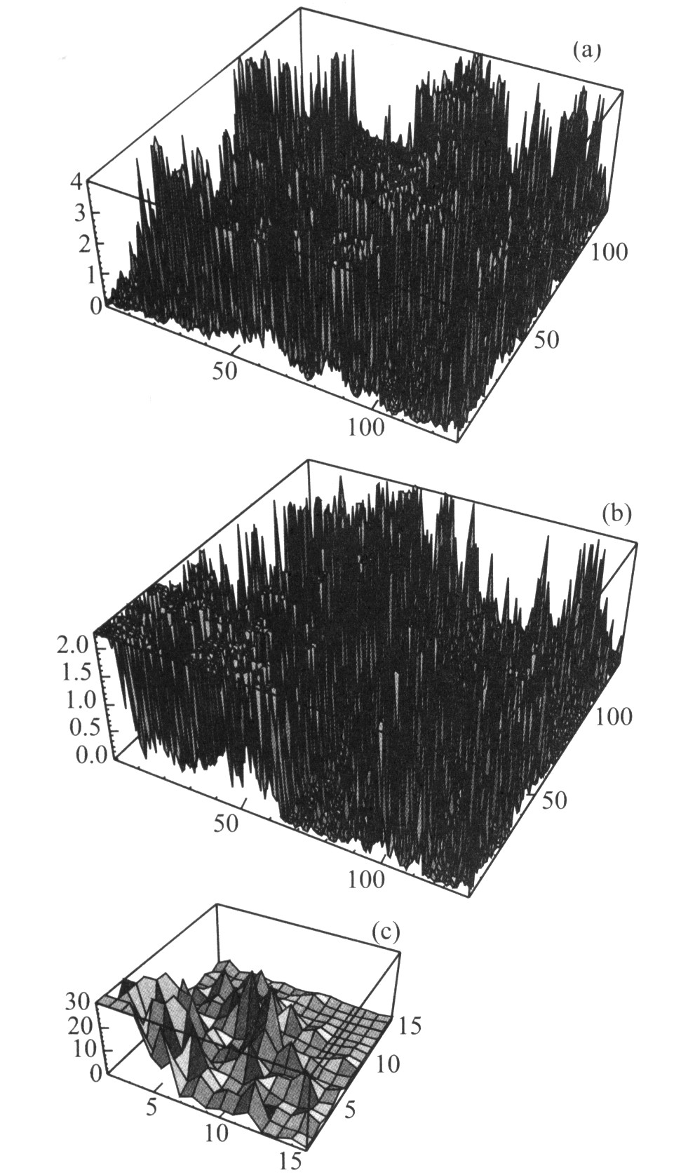
Using a simple multifractal model based on the model De Wijs, various geochemical map patterns for element concentration values are being simulated. Each pattern is self-similar on the average in that a similar pattern can be derived by application of the multiplicative cascade model used to any small subarea on the pattern. In other experiments, the original, self-similar pattern is distorted by superimposing a 2-dimensional trend pattern and by mixing it with a constant concentration value model. It is investigated how such distortions change the multifractal spectrum estimated by means of the 3-step method of moments. Discrete and continuous frequency distribution models are derived for patterns that satisfy the model of De Wijs. These simulated patterns satisfy a discrete frequency distribution model that as upper bound has a continuous frequency distribution to which it approaches in form when the subdivisions of the multiplicative cascade model are repeated indefinitely. This limiting distribution is lognormal in the center and has Pareto tails. Potentially, this approach has important implications in mineral and oil resource evaluation.
Using a simple multifractal model based on the model De Wijs, various geochemical map patterns for element concentration values are being simulated. Each pattern is self-similar on the average in that a similar pattern can be derived by application of the multiplicative cascade model used to any small subarea on the pattern. In other experiments, the original, self-similar pattern is distorted by superimposing a 2-dimensional trend pattern and by mixing it with a constant concentration value model. It is investigated how such distortions change the multifractal spectrum estimated by means of the 3-step method of moments. Discrete and continuous frequency distribution models are derived for patterns that satisfy the model of De Wijs. These simulated patterns satisfy a discrete frequency distribution model that as upper bound has a continuous frequency distribution to which it approaches in form when the subdivisions of the multiplicative cascade model are repeated indefinitely. This limiting distribution is lognormal in the center and has Pareto tails. Potentially, this approach has important implications in mineral and oil resource evaluation.


2001, 26(2): 152-156.
Abstract:
Future quantitative assessments will be expected to estimate quantities, values, and locations of undiscovered mineral resources in a form that conveys both economic viability and uncertainty associated with the resources. Historically, declining metal prices point to the need for larger deposits over time. Sensitivity analysis demonstrates that the greatest opportunity for reducing uncertainty in assessments lies in lowering uncertainty associated with tonnage estimates. Of all errors possible in assessments, those affecting tonnage estimates are by far the most important. Selecting the correct deposit model is the most important way of controlling errors because the dominance of tonnage-deposit models are the best known predictor of tonnage. Much of the surface is covered with apparently barren rocks and sediments in many large regions. Because many exposed mineral deposits are believed to have been found, a prime concern is the presence of possible mineralized rock under cover. Assessments of areas with resources under cover must rely on extrapolation from surrounding areas, new geologic maps of rocks under cover, or analogy with other well-explored areas that can be considered training tracts. Cover has a profound effect on uncertainty and on methods and procedures of assessments because geology is seldom known and geophysical methods typically have attenuated responses. Many earlier assessment methods were based on relationships of geochemical and geophysical variables to deposits learned from deposits exposed on the surface-these will need to be relearned based on covered deposits. Mineral-deposit models are important in quantitative resource assessments for two reasons: (1) grades and tonnages of most deposit types are significantly different, and (2) deposit types are present in different geologic settings that can be identified from geologic maps. Mineral-deposit models are the keystone in combining the diverse geoscience information on geology, mineral occurrences, geophysics, and geochemistry used in resource assessments and mineral exploration. Grade and tonnage models and development of quantitative descriptive, economic, and deposit density models will help reduce the uncertainty of these new assessments.
Future quantitative assessments will be expected to estimate quantities, values, and locations of undiscovered mineral resources in a form that conveys both economic viability and uncertainty associated with the resources. Historically, declining metal prices point to the need for larger deposits over time. Sensitivity analysis demonstrates that the greatest opportunity for reducing uncertainty in assessments lies in lowering uncertainty associated with tonnage estimates. Of all errors possible in assessments, those affecting tonnage estimates are by far the most important. Selecting the correct deposit model is the most important way of controlling errors because the dominance of tonnage-deposit models are the best known predictor of tonnage. Much of the surface is covered with apparently barren rocks and sediments in many large regions. Because many exposed mineral deposits are believed to have been found, a prime concern is the presence of possible mineralized rock under cover. Assessments of areas with resources under cover must rely on extrapolation from surrounding areas, new geologic maps of rocks under cover, or analogy with other well-explored areas that can be considered training tracts. Cover has a profound effect on uncertainty and on methods and procedures of assessments because geology is seldom known and geophysical methods typically have attenuated responses. Many earlier assessment methods were based on relationships of geochemical and geophysical variables to deposits learned from deposits exposed on the surface-these will need to be relearned based on covered deposits. Mineral-deposit models are important in quantitative resource assessments for two reasons: (1) grades and tonnages of most deposit types are significantly different, and (2) deposit types are present in different geologic settings that can be identified from geologic maps. Mineral-deposit models are the keystone in combining the diverse geoscience information on geology, mineral occurrences, geophysics, and geochemistry used in resource assessments and mineral exploration. Grade and tonnage models and development of quantitative descriptive, economic, and deposit density models will help reduce the uncertainty of these new assessments.

2001, 26(2): 157-160.
Abstract:
In this paper, the basic concepts and the system frame of the Digital Earth are introduced. The basic concepts of the digital mineral project on the basis of the technology system of the Digital Earth are generalized. Also discussed is the necessity to establish a basic database of mineral resources in the whole world, with an account of the major content of the database. At the same time the basic method for statistical prognosis of giant deposits based on the technology system of the Digital Earth is studied.
In this paper, the basic concepts and the system frame of the Digital Earth are introduced. The basic concepts of the digital mineral project on the basis of the technology system of the Digital Earth are generalized. Also discussed is the necessity to establish a basic database of mineral resources in the whole world, with an account of the major content of the database. At the same time the basic method for statistical prognosis of giant deposits based on the technology system of the Digital Earth is studied.

2001, 26(2): 161-166.
Abstract:
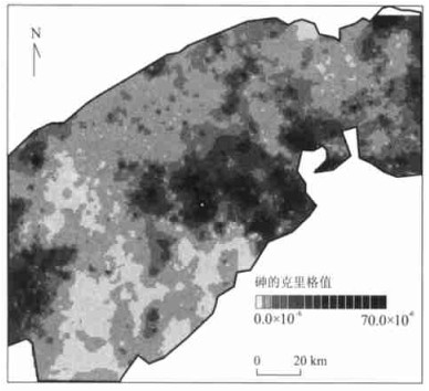
Spatial textural analysis of exploration geochemical and geophysical data includes spatial association and singularity. Spatial variability and association can be measured using variogram, which has been commonly used in geostatistics. The singularity can be analyzed in multifractal modeling. Singularity in the application to geochemical data can reflect the regularity of enrichment and dispersion of elements due to mineralization. The method introduced in the paper can take into account both spatial variability and singularity in data estimation and data interpolation. It can be used to conduct data interpolation as well as retain local texture information, which is essential for analyzing and interpreting geochemical data for mineral exploration. The case study of identification of Au and Sn-W-U mineralization-related alterations from lake sediment geochemical data in the southwestern Nova Scotia, Canada, has demonstrated that the singularity exponent involved in the multifractal interpolation method may characterize the alteration or other local areas favourable for mineralization.
Spatial textural analysis of exploration geochemical and geophysical data includes spatial association and singularity. Spatial variability and association can be measured using variogram, which has been commonly used in geostatistics. The singularity can be analyzed in multifractal modeling. Singularity in the application to geochemical data can reflect the regularity of enrichment and dispersion of elements due to mineralization. The method introduced in the paper can take into account both spatial variability and singularity in data estimation and data interpolation. It can be used to conduct data interpolation as well as retain local texture information, which is essential for analyzing and interpreting geochemical data for mineral exploration. The case study of identification of Au and Sn-W-U mineralization-related alterations from lake sediment geochemical data in the southwestern Nova Scotia, Canada, has demonstrated that the singularity exponent involved in the multifractal interpolation method may characterize the alteration or other local areas favourable for mineralization.


2001, 26(2): 167-171.
Abstract:
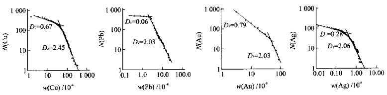
Element geochemical distribution pattern from regional to local which resulted from Zhuji area, Zhejiang Province has been studied. It is shown that element distributions obey mutifractal distribution which can be used to interpret relation between geochemical background and anomaly. There is a hierarchy of geochemical patterns above known deposits. Finally, since geochemical laws can apply to various scales, and are scale-invariant, they should be treated with the modern concept of scale-invariance.
Element geochemical distribution pattern from regional to local which resulted from Zhuji area, Zhejiang Province has been studied. It is shown that element distributions obey mutifractal distribution which can be used to interpret relation between geochemical background and anomaly. There is a hierarchy of geochemical patterns above known deposits. Finally, since geochemical laws can apply to various scales, and are scale-invariant, they should be treated with the modern concept of scale-invariance.

2001, 26(2): 172-175.
Abstract:
The concept of stratigraphic pile-up sequences and decomposition model of overlapping process of Logistic chaotic series are applied to extract the weak signal for the sequence of lithologic ratio parameters, which has established the basis for dynamic modeling of three dimensions in the paleogeographic environment of hydrothermal sedimentary basin.
The concept of stratigraphic pile-up sequences and decomposition model of overlapping process of Logistic chaotic series are applied to extract the weak signal for the sequence of lithologic ratio parameters, which has established the basis for dynamic modeling of three dimensions in the paleogeographic environment of hydrothermal sedimentary basin.

2001, 26(2): 176-179.
Abstract:
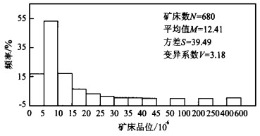
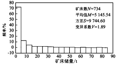
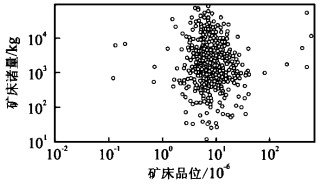
The grade-tonnage model of deposits belongs to the pre-area of the subject, the important part of the system exploration theory. The article establishes a geological model, a grade model, tonnage model and a joint model of grade-tonnage for 680 original gold deposits in China and a tonnage sequence model of quartz-vein gold deposits of the whole country, according to "The Mineral Resources Data Base of the Whole Country in 1997". The model types include frequency histogram, cumulative frequency distributing graph and theoretical model with double logarithmic coordinates. The paper sums up separately the typical mathematical geological characteristics of grade-tonnage distribution of original gold deposits in China and discusses significance and function of the tonnage sequence model in the field of mineral resources evaluation.
The grade-tonnage model of deposits belongs to the pre-area of the subject, the important part of the system exploration theory. The article establishes a geological model, a grade model, tonnage model and a joint model of grade-tonnage for 680 original gold deposits in China and a tonnage sequence model of quartz-vein gold deposits of the whole country, according to "The Mineral Resources Data Base of the Whole Country in 1997". The model types include frequency histogram, cumulative frequency distributing graph and theoretical model with double logarithmic coordinates. The paper sums up separately the typical mathematical geological characteristics of grade-tonnage distribution of original gold deposits in China and discusses significance and function of the tonnage sequence model in the field of mineral resources evaluation.


2001, 26(2): 180-184.
Abstract:
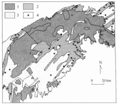
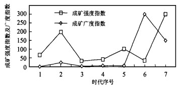
The time spectrum of mineral deposits shows the diversity of mineralization. Former researchers have studied it by way of ore deposit, geochemistry and statistics on a scale of globe, region and mineral deposits. By studying this spectrum of multiple ore kinds in Lancangjiang River region, Yunnan Province, this paper discusses the methods to establish the time spectrum of mineral deposits of multiple ore kinds and single ore kind — lead-zinc deposits using geographic information system (GIS). The ore-forming scope index and the ore-forming intensity index are the main parameters with the GIS analysis as the tool. While the division of this kind of spectrum is based on the curves of the ore-forming scope and the ore-forming intensity. The authors emphasize the necessity to combine qualitative ore-forming analysis with quantitative GIS methods, and point out the inherent relation between the time spectrum and the spatial spectrum of mineral deposits.
The time spectrum of mineral deposits shows the diversity of mineralization. Former researchers have studied it by way of ore deposit, geochemistry and statistics on a scale of globe, region and mineral deposits. By studying this spectrum of multiple ore kinds in Lancangjiang River region, Yunnan Province, this paper discusses the methods to establish the time spectrum of mineral deposits of multiple ore kinds and single ore kind — lead-zinc deposits using geographic information system (GIS). The ore-forming scope index and the ore-forming intensity index are the main parameters with the GIS analysis as the tool. While the division of this kind of spectrum is based on the curves of the ore-forming scope and the ore-forming intensity. The authors emphasize the necessity to combine qualitative ore-forming analysis with quantitative GIS methods, and point out the inherent relation between the time spectrum and the spatial spectrum of mineral deposits.


2001, 26(2): 185-188.
Abstract:
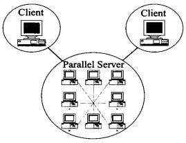
Multi-stage and plural process of mineralization, multivariable metallogenetic factors, multidimensional and multiresolution of ore-forming space, bring about the complexity in simulating ore-forming process, and difficulty to simulate it in real-time by one computer. Under the Ethernet with PC cluster, it is practicable to simulate the mineralization of 3D by means of memory sharing and task distribution of parallel computing. The prototype system, based on Client-Server, plug-in and algorithmization, is effective in image processing and with linear speed-ups, tested by 8 PCs.
Multi-stage and plural process of mineralization, multivariable metallogenetic factors, multidimensional and multiresolution of ore-forming space, bring about the complexity in simulating ore-forming process, and difficulty to simulate it in real-time by one computer. Under the Ethernet with PC cluster, it is practicable to simulate the mineralization of 3D by means of memory sharing and task distribution of parallel computing. The prototype system, based on Client-Server, plug-in and algorithmization, is effective in image processing and with linear speed-ups, tested by 8 PCs.


2001, 26(2): 189-191.
Abstract:
GIS is an advanced technology and is widely applied in the exploration and assessment of mineral resources. With MapInfo platform and MapBasic program, Mineral Resources Assessment System has been developed by using multiparameter geological information, in which MapInfo functions are expanded and spatial analysis and metallogenic prognosis methods are added. With this method aero geophysical database in the eastern Tianshan region of Xinjiang is established and the alteration gold deposits in this area are assessed comprehensively. Study results show that it is the effective way for metallogenic prognosis that traditional explanation method is combined with mathematical statistics and GIS.
GIS is an advanced technology and is widely applied in the exploration and assessment of mineral resources. With MapInfo platform and MapBasic program, Mineral Resources Assessment System has been developed by using multiparameter geological information, in which MapInfo functions are expanded and spatial analysis and metallogenic prognosis methods are added. With this method aero geophysical database in the eastern Tianshan region of Xinjiang is established and the alteration gold deposits in this area are assessed comprehensively. Study results show that it is the effective way for metallogenic prognosis that traditional explanation method is combined with mathematical statistics and GIS.


2001, 26(2): 192-196.
Abstract:
In order to carry out field geological mapping and data acquiring with computer assisted technology, the focus should be put on the acquiring of field geological spatial entity data, so as to develop geological mapping field data acquiring system. With the help of software engineering and system engineering, the combination of object-oriented software developing technology with practical field mapping is applied in every stage of the system development.Methodsfor the analysis of the field mapping spatial entity and the analysis models for its data object are studied. In this paper, the building of E-C-R model of field geological spatial entity, class hierarchy and information structure model are discussed. These models have been the base of this system development and satisfactory effect has been achieved.
In order to carry out field geological mapping and data acquiring with computer assisted technology, the focus should be put on the acquiring of field geological spatial entity data, so as to develop geological mapping field data acquiring system. With the help of software engineering and system engineering, the combination of object-oriented software developing technology with practical field mapping is applied in every stage of the system development.Methodsfor the analysis of the field mapping spatial entity and the analysis models for its data object are studied. In this paper, the building of E-C-R model of field geological spatial entity, class hierarchy and information structure model are discussed. These models have been the base of this system development and satisfactory effect has been achieved.


2001, 26(2): 197-200.
Abstract:
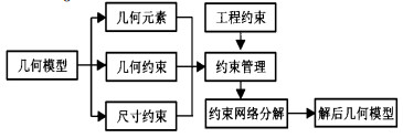
Because of some disadvantages of current CAD technology, the design efficiency and application of computer-aided resources map generation system in different departments and users were limited. In this paper a new parametric graph design method is presented to solve this problem. Based on the analysis of map generation system features and parametric design theory, difficulties and means of the application approaches of the system to parametric design method and actual parametric design system are put forward, such as map model design and reuses, adaptability of map model itself and establishment of parametric graph library. The realization and application of parametric design method may improve prominently the functional agility and flexibility of map generation system.
Because of some disadvantages of current CAD technology, the design efficiency and application of computer-aided resources map generation system in different departments and users were limited. In this paper a new parametric graph design method is presented to solve this problem. Based on the analysis of map generation system features and parametric design theory, difficulties and means of the application approaches of the system to parametric design method and actual parametric design system are put forward, such as map model design and reuses, adaptability of map model itself and establishment of parametric graph library. The realization and application of parametric design method may improve prominently the functional agility and flexibility of map generation system.


2001, 26(2): 201-204.
Abstract:
When we construct a database to store the complicated geological attribute data, we need many interfaces to input the data if we use the routine database data model. So it will be very difficult to input the data into right places and learn to use this kind of system. In addition, it is impossible to do some necessary change and expansion to the data structure and interface as soon as the system development is completed and the data model and the system interface are fixed. These problems can be solved by using the dynamic data model, which is established based on the data dictionary technique and data converse standardization technique, data digging technique and by separating the inputting data model and data storage model. As a result, the database built by using the dynamic data model can be more practicable, adjustable and vital to the system.
When we construct a database to store the complicated geological attribute data, we need many interfaces to input the data if we use the routine database data model. So it will be very difficult to input the data into right places and learn to use this kind of system. In addition, it is impossible to do some necessary change and expansion to the data structure and interface as soon as the system development is completed and the data model and the system interface are fixed. These problems can be solved by using the dynamic data model, which is established based on the data dictionary technique and data converse standardization technique, data digging technique and by separating the inputting data model and data storage model. As a result, the database built by using the dynamic data model can be more practicable, adjustable and vital to the system.


2001, 26(2): 205-209.
Abstract:
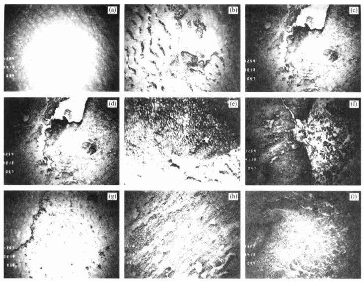
The mineralizing characters relating to type, shape, composition structure and distribution of cobalt-rich ferromanganese nodule and crust in Pacific ocean seamount have been discussed by investigating information of two surveyings and using the other data. The results indicate that the cobalt-rich development in central Pacific oceanic seamount area, and the mineralizing characters are controlled by the environmental factors, such as landform, water depth and rock types.
The mineralizing characters relating to type, shape, composition structure and distribution of cobalt-rich ferromanganese nodule and crust in Pacific ocean seamount have been discussed by investigating information of two surveyings and using the other data. The results indicate that the cobalt-rich development in central Pacific oceanic seamount area, and the mineralizing characters are controlled by the environmental factors, such as landform, water depth and rock types.
2001, 26(2): 210-212.
Abstract:
This paper discusses the conception of Mineral Resources Competitive Power (MRCP) and analyses the factors that affect the MRCP, according to the characteristics of mineral resources exploitation. The index system for assessing the MRCP is established and the fuzzy comprehensive assessment model is built based on the principles of fuzzy comprehensive assessment. The compared assessment of competitive power is made of Lanping, Changba and Fankou lead-zinc deposits.
This paper discusses the conception of Mineral Resources Competitive Power (MRCP) and analyses the factors that affect the MRCP, according to the characteristics of mineral resources exploitation. The index system for assessing the MRCP is established and the fuzzy comprehensive assessment model is built based on the principles of fuzzy comprehensive assessment. The compared assessment of competitive power is made of Lanping, Changba and Fankou lead-zinc deposits.
2001, 26(2): 213-216.
Abstract:
Focus issue method is a new indicator system of sustainable development of mineral resources. Its evaluation criteria are: the sustainable utility of mineral resources; the impact of the development of mineral resources on environments; the sustainable development of the mining industry. Moreover, several dynamic indicators of mineral resources are introduced: competitiveness, consumption level, consumption structure, carrying capacity, destruction power, environmental protection and development capacity. Therefore, dynamical evaluation can be made possible of the sustainable development of mineral resources.
Focus issue method is a new indicator system of sustainable development of mineral resources. Its evaluation criteria are: the sustainable utility of mineral resources; the impact of the development of mineral resources on environments; the sustainable development of the mining industry. Moreover, several dynamic indicators of mineral resources are introduced: competitiveness, consumption level, consumption structure, carrying capacity, destruction power, environmental protection and development capacity. Therefore, dynamical evaluation can be made possible of the sustainable development of mineral resources.

2001, 26(2): 217-220.
Abstract:
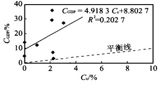
By using seven parameters such as the growth rates of urbanization, per capita GDP, yield per mou of grain crops, consumption of pesticides and chemical fertilizers and decreasing rate of cultivated land and per capita cultivated land, the authors proposed four indicators: the land utilization intensification coefficient, the land consumption redound coefficient, the land production coefficient and the land contamination coefficient. According to the indicators, a new model—trendline-equality line (TLEL model) is established to evaluate the quality and sustainable utilization of land resources in different areas in each development period, such as in Meizhou, Guangdong Province during the 1990s. The result indicates that the indicators and the TLEL model are appropriate for macroscopical assessment of the actuality and trend forecasting of the land resources utilization.
By using seven parameters such as the growth rates of urbanization, per capita GDP, yield per mou of grain crops, consumption of pesticides and chemical fertilizers and decreasing rate of cultivated land and per capita cultivated land, the authors proposed four indicators: the land utilization intensification coefficient, the land consumption redound coefficient, the land production coefficient and the land contamination coefficient. According to the indicators, a new model—trendline-equality line (TLEL model) is established to evaluate the quality and sustainable utilization of land resources in different areas in each development period, such as in Meizhou, Guangdong Province during the 1990s. The result indicates that the indicators and the TLEL model are appropriate for macroscopical assessment of the actuality and trend forecasting of the land resources utilization.