


2001 Vol. 26, No. 3
Display Method:
2001, 26(3): 221-228+331-332.
 PDF 632KB
Abstract:
The present paper deals with the composition, features and ages of the flora in the Zhenzhuchong Formation, north borderof Sichuan basin. The plant fossilsobtained are identified to belong to 95 species of 47 genera. This flora should be classified as Ptilophyllum-Coniopteris assemblage in the upper part of the Dictyophyllum-Clathropteris series in age equivalent to the Pliensbachian-Aalenian stage. In this sense, it can be closely associated with the Thaumatopteris zones in Greenland and Sweden. This paper also discusses the Jurassic paleoclimate in the Sichuan basin with the emphasison the relationship between the Early Jurassic sedimentary environment and the coal-forming. It concludes that the increase of the humidity and the decrease of the temperature may have favored the formation of the coal.
The present paper deals with the composition, features and ages of the flora in the Zhenzhuchong Formation, north borderof Sichuan basin. The plant fossilsobtained are identified to belong to 95 species of 47 genera. This flora should be classified as Ptilophyllum-Coniopteris assemblage in the upper part of the Dictyophyllum-Clathropteris series in age equivalent to the Pliensbachian-Aalenian stage. In this sense, it can be closely associated with the Thaumatopteris zones in Greenland and Sweden. This paper also discusses the Jurassic paleoclimate in the Sichuan basin with the emphasison the relationship between the Early Jurassic sedimentary environment and the coal-forming. It concludes that the increase of the humidity and the decrease of the temperature may have favored the formation of the coal.


2001, 26(3): 229-234.
Abstract:
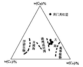
Series of molecular fossils, including n-alkanes, extended tricyclic terpanes, hopanes and regular steranes, have been detected from the red clastic strata of Middle Jurassic-Early Cretaceous in Jianmenguan profile, Sichuan basin in China. These molecular fossils are supposed to be derived from higher plants and aquatic organisms. Their parameters such as low gammaceran abundance, relative higher w (Pr) / w (Ph) and the dominance of C27-ethylcholestane suggest the occurrence of a limnetic, non reductive continental environment in the study area during Middle Jurassic and Early Cretaceous. C27 and C29 n-alkanes, believed to be related to woody plants, constitute the main high carbon number n-alkanes in the studied samples, while C31 n-alkane, supposed to be the main n-alkane in herbal plants, does not prevail over C27 and/or C29 n-alkanes in the samples. This suggests the flourishing of woody plants other than grassy plants at that geological time. This kind of vegetation further indicates the existence of a warm and humid climate from Middle Jurassic-Early Cretaceous, a kind of climate favorable for the development of the red basin. This investigation of the red sedimentary rocks shows that the molecular fossils have a high potential in recovering the paleoenvironment, paleo-vegetation and palaeo climate.
Series of molecular fossils, including n-alkanes, extended tricyclic terpanes, hopanes and regular steranes, have been detected from the red clastic strata of Middle Jurassic-Early Cretaceous in Jianmenguan profile, Sichuan basin in China. These molecular fossils are supposed to be derived from higher plants and aquatic organisms. Their parameters such as low gammaceran abundance, relative higher w (Pr) / w (Ph) and the dominance of C27-ethylcholestane suggest the occurrence of a limnetic, non reductive continental environment in the study area during Middle Jurassic and Early Cretaceous. C27 and C29 n-alkanes, believed to be related to woody plants, constitute the main high carbon number n-alkanes in the studied samples, while C31 n-alkane, supposed to be the main n-alkane in herbal plants, does not prevail over C27 and/or C29 n-alkanes in the samples. This suggests the flourishing of woody plants other than grassy plants at that geological time. This kind of vegetation further indicates the existence of a warm and humid climate from Middle Jurassic-Early Cretaceous, a kind of climate favorable for the development of the red basin. This investigation of the red sedimentary rocks shows that the molecular fossils have a high potential in recovering the paleoenvironment, paleo-vegetation and palaeo climate.

2001, 26(3): 235-240.
Abstract:
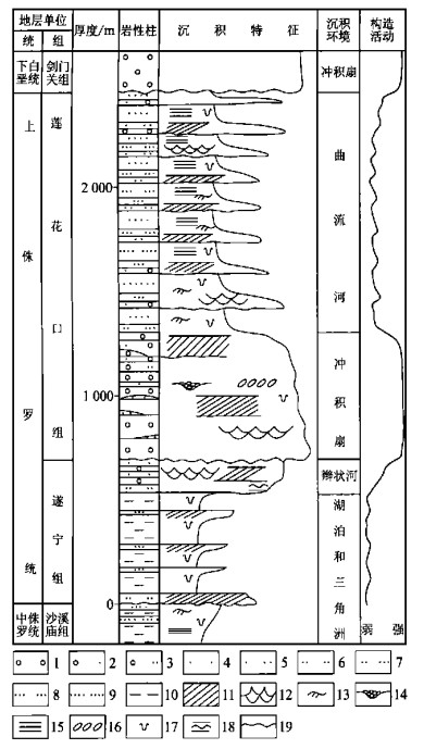
Late Jurassic is an important period of Longmenshan foreland basin development. It is of great significance to study its depositional system and paleoenvironmental evolution. According to comparative sedimentology and the study of sedimentary sequences and cycles, Upper Jurassic in the study area can be divided into lake, delta, alluvial fan and fluvial depositional systems. The depositional setting and evolution analyses reveal that Longmenshan nappe structure belt should be responsible for the paleoenvironmental evolution and depositional system disposition of the study area in Late Jurassic. The research results show that the main provinces come from Longmengshan mountain in the northwestern part of the study area.
Late Jurassic is an important period of Longmenshan foreland basin development. It is of great significance to study its depositional system and paleoenvironmental evolution. According to comparative sedimentology and the study of sedimentary sequences and cycles, Upper Jurassic in the study area can be divided into lake, delta, alluvial fan and fluvial depositional systems. The depositional setting and evolution analyses reveal that Longmenshan nappe structure belt should be responsible for the paleoenvironmental evolution and depositional system disposition of the study area in Late Jurassic. The research results show that the main provinces come from Longmengshan mountain in the northwestern part of the study area.


2001, 26(3): 241-246.
Abstract:
Sedimentary facies and paleontology are synthetically analyzed in order to clarify the evolution and paleo climate of Shichuan basin during Jurassic and Cretaceous. The study shows that the tectogenesis around the basin can be divided into two cycles during Jurassic and Cretaceous. One began from Early Jurassic and ended in Middle Jurassic and the other one from Late Jurassic to Early Cretaceous. The basin was widely covered by mudstone, sandstone and shell limestone of lake facies in the early stage of the above two cycles. The thickness is relatively small and the sedimentary particles are much more fine grained both in the early stage of the two cycles, showing that the tectogenesis is relatively stable. However, in the late stage the basin is characterized by widely spread varicolored thick sandstone, mudstone and conglomerate of river or alluvial fan facies. Even more, there are usually sediments and coarse sedimentary particles of large thickness in the late stages, reflecting rapid uplift of the mountains around the basin. According to the study of sedimentation and fossils, Sichuan basin should have a warm climate during the first cycle and hot climate from the beginning of the second cycle.
Sedimentary facies and paleontology are synthetically analyzed in order to clarify the evolution and paleo climate of Shichuan basin during Jurassic and Cretaceous. The study shows that the tectogenesis around the basin can be divided into two cycles during Jurassic and Cretaceous. One began from Early Jurassic and ended in Middle Jurassic and the other one from Late Jurassic to Early Cretaceous. The basin was widely covered by mudstone, sandstone and shell limestone of lake facies in the early stage of the above two cycles. The thickness is relatively small and the sedimentary particles are much more fine grained both in the early stage of the two cycles, showing that the tectogenesis is relatively stable. However, in the late stage the basin is characterized by widely spread varicolored thick sandstone, mudstone and conglomerate of river or alluvial fan facies. Even more, there are usually sediments and coarse sedimentary particles of large thickness in the late stages, reflecting rapid uplift of the mountains around the basin. According to the study of sedimentation and fossils, Sichuan basin should have a warm climate during the first cycle and hot climate from the beginning of the second cycle.

2001, 26(3): 247-250+257.
Abstract:
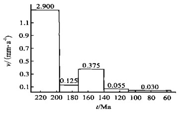
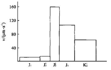
It is found that the values of magnetic susceptibility have apparent relations with the size of sedimentary particles based on the study of magnetic susceptibility of Upper Jurassic and Lower Cretaceous in Jianmenguan, Sichuan Province. Sediments with medium or coarse grained particles usually have low values of magnetic susceptibility, while the fine grained sandstone, silt and mudstone often appear to have much higher values. As sedimentary rate has something to do with the size of sedimentary particles, this susceptibility can be used as a quantitative indicator for the variation of sedimentary rate. What's more, the sedimentary rate usually varies in different environments, so the magnetic susceptibility can also be used as reference of sedimentary facies. The study of magnetic susceptibility anisotropy in Jurassic and Cretaceous shows that there exit two maximal axis directions of magnetic susceptibility in the study area of Jianmenguan. The southeastward maximal axis direction corresponds to the direction of paleocurrent in the area. However, the southwestward maximal axis direction is probably caused by tectonism.
It is found that the values of magnetic susceptibility have apparent relations with the size of sedimentary particles based on the study of magnetic susceptibility of Upper Jurassic and Lower Cretaceous in Jianmenguan, Sichuan Province. Sediments with medium or coarse grained particles usually have low values of magnetic susceptibility, while the fine grained sandstone, silt and mudstone often appear to have much higher values. As sedimentary rate has something to do with the size of sedimentary particles, this susceptibility can be used as a quantitative indicator for the variation of sedimentary rate. What's more, the sedimentary rate usually varies in different environments, so the magnetic susceptibility can also be used as reference of sedimentary facies. The study of magnetic susceptibility anisotropy in Jurassic and Cretaceous shows that there exit two maximal axis directions of magnetic susceptibility in the study area of Jianmenguan. The southeastward maximal axis direction corresponds to the direction of paleocurrent in the area. However, the southwestward maximal axis direction is probably caused by tectonism.

2001, 26(3): 251-257.
Abstract:
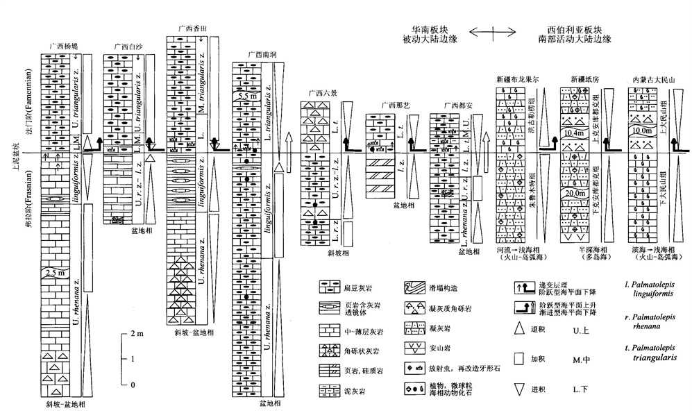
Seven kinds of physical event deposits have been recognized in the Frasnian/Famennian transition of both the passive continental margin of the South China plate and southern active continental margin of the Siberian plate. They are fine calcareous turbidite facies, calcareous breccia facies, limestone facies with soft-sediment deformation, wackestone facies with microspherules, tuffaceous breccia facies, black shale facies and volcanic explosive and effusive facies and they are widely distributed in the bottom of the Lower Palmatolepis triangularis zone of the Famennian and/or in the bottom of the Upper Palmatolepis rhenana zone of the Frasnian. These event deposits must have been induced by two-time asteroid impact events and should be good indicators of high resolution chronostratigraphic correlation. Data indicated that the sea-level changes were not synchronal and that there existed two types of saltatory and gradual sea level changes, and five kinds of different characteristics in sea-level changes from the latest Frasnian to the earliest Famennian in China and other regions of the world. They were the latest Frasnian sea-level falling → the earliest Famennian sea-level rising, the latest Frasnian sea-level rising → the earliest Famennian sea-level falling, the latest Frasnian sea-level rising → the earliest Famennian sea level rising, the latest Frasnian sea-level falling → the earliest Famennian sea-level falling, the Frasnian/Famennian transitional sea-level still. The stepped mass extinction of the Frasnian/Famennian transition may be closely related to six-time asteroid impact events from the bottom of the Upper Palmatolepis rhenana zone to the Palmatolepis crepida zone.
Seven kinds of physical event deposits have been recognized in the Frasnian/Famennian transition of both the passive continental margin of the South China plate and southern active continental margin of the Siberian plate. They are fine calcareous turbidite facies, calcareous breccia facies, limestone facies with soft-sediment deformation, wackestone facies with microspherules, tuffaceous breccia facies, black shale facies and volcanic explosive and effusive facies and they are widely distributed in the bottom of the Lower Palmatolepis triangularis zone of the Famennian and/or in the bottom of the Upper Palmatolepis rhenana zone of the Frasnian. These event deposits must have been induced by two-time asteroid impact events and should be good indicators of high resolution chronostratigraphic correlation. Data indicated that the sea-level changes were not synchronal and that there existed two types of saltatory and gradual sea level changes, and five kinds of different characteristics in sea-level changes from the latest Frasnian to the earliest Famennian in China and other regions of the world. They were the latest Frasnian sea-level falling → the earliest Famennian sea-level rising, the latest Frasnian sea-level rising → the earliest Famennian sea-level falling, the latest Frasnian sea-level rising → the earliest Famennian sea level rising, the latest Frasnian sea-level falling → the earliest Famennian sea-level falling, the Frasnian/Famennian transitional sea-level still. The stepped mass extinction of the Frasnian/Famennian transition may be closely related to six-time asteroid impact events from the bottom of the Upper Palmatolepis rhenana zone to the Palmatolepis crepida zone.
2001, 26(3): 258-260.
Abstract:
The effect of immersion and digestion of gallium in bauxite by HCl is studied in this paper with the results of a series of conditional experiments. The results show that under the condition of 500 ℃, samples of bauxite are calcined for three hours, then immersed in HCl solution when concentration is 6 mol/L, and digested for twelve hours, with its ratio of solid to liquid being 1∶2.5. In this way, the ratio of digestion to total gallium in bauxite is beyond 94%.
The effect of immersion and digestion of gallium in bauxite by HCl is studied in this paper with the results of a series of conditional experiments. The results show that under the condition of 500 ℃, samples of bauxite are calcined for three hours, then immersed in HCl solution when concentration is 6 mol/L, and digested for twelve hours, with its ratio of solid to liquid being 1∶2.5. In this way, the ratio of digestion to total gallium in bauxite is beyond 94%.


2001, 26(3): 261-268.
Abstract:
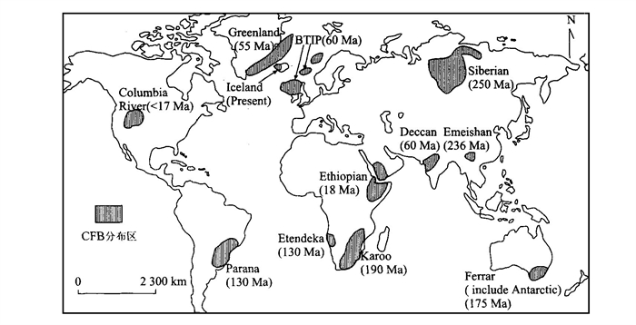
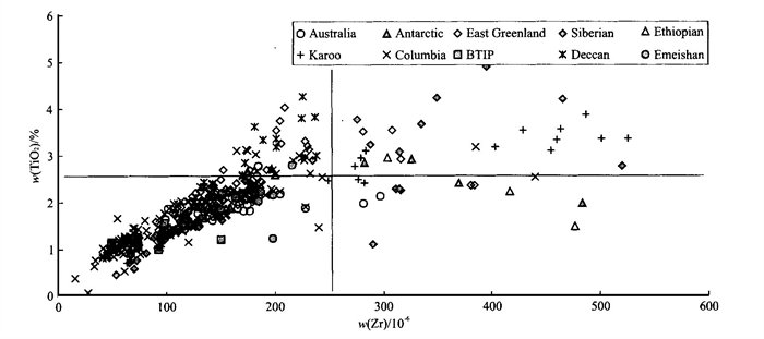
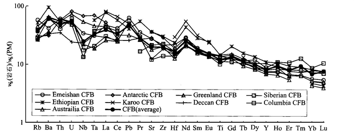
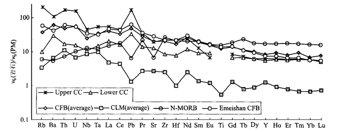
A close genetic relationship is present between the rapidly upwelling continental flood basalts(CFB)and the continent rift. On the whole, the petrologic and geochemical compositions are homogeneous and enriched with isotopes and incompatible trace elements. However, some samples contain conspicuous depleted compositions, reflecting a general mantle heterogeneity. The mantle plume originating from upper/lower mantle boundary or asthenosphere might have served as the major materials and energies required for CFB that has not been fully assimilated by the crust. The metasomatism between the dehydrated fluid in the subduction zone or the thermal mantle plume itself and its wall rocks determines that the metasomatic lithosphere mantle with a great effect on the formation of CFB, is a major cause of the trace elements and isotope characteristics of CFB.
A close genetic relationship is present between the rapidly upwelling continental flood basalts(CFB)and the continent rift. On the whole, the petrologic and geochemical compositions are homogeneous and enriched with isotopes and incompatible trace elements. However, some samples contain conspicuous depleted compositions, reflecting a general mantle heterogeneity. The mantle plume originating from upper/lower mantle boundary or asthenosphere might have served as the major materials and energies required for CFB that has not been fully assimilated by the crust. The metasomatism between the dehydrated fluid in the subduction zone or the thermal mantle plume itself and its wall rocks determines that the metasomatic lithosphere mantle with a great effect on the formation of CFB, is a major cause of the trace elements and isotope characteristics of CFB.


2001, 26(3): 269-278.
Abstract:
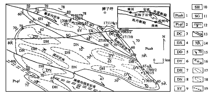
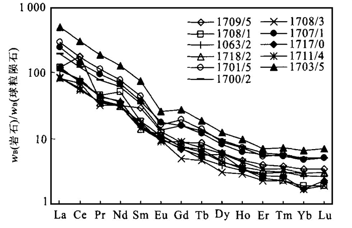
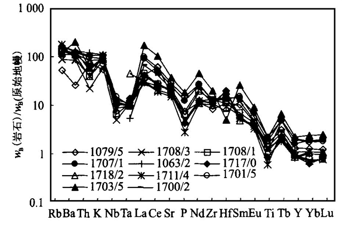
Huichizi complex pluton, the largest granitoid pluton in the core of northern Qinling orogenic belt, is composed of three sequences. These granitoid rocks have higher SiO2 (66.86%-73.48%), Al2O3 (14.44%-16.32%), abundant Na2O (4.17%-4.78%), and lower TiO2 (< 0.74%), MgO (< 1.18%) and K2O (< 3.33%) mass fraction, and more enriched in LREE (27.45 < w (La)N/ w (Yb)N < 72.99), and distinct negative and weak positive Eu anomaly. In these granitoid rocks, Y, Yb, Sr mass fractions and w (Sr) / w (Y) ratio of trace elements vary respectively from 3.70×10⁻⁶ to 9.77×10⁻⁶ (< 18×10-6), 0.30×10⁻⁶ to 1.14×10⁻⁶ (< 1.90×10⁻⁶), 310×10-6 to 775×10-6 and 47.87 to 114.36. While those of Huichizi complex display multi element patterns with large positive ion lithophile elements (Rb, Ba, Th and Sr) anomalies and high negative field strong elements (Nb, Ta, Ti and Zr) anomalies and indicate the geochemical characteristics of calc alkalic granites and volcanic arc granites. All the granitoid rocks exhibit a similar range of Nd and Sr isotopic ratios: 0.512 31 < w (143Nd) / w (144Nd) < 0.512 38), 0.707 83 < w (87Sr) / w (86Sr) < 0.708 80, 0.95 Ga < tDM (depleted mantle model age) < 1.09 Ga, -0.81 < ε (Nd, 437 Ma) < 0.93 and 18 < ε (Sr, 437 Ma) < 32, and show the source of Huichizi complex from basic rocks. These characteristics are similar to those of the Adakitic rocks. The authors think that the granitoid rocks of Huichizi complex may have been the result of the subduction of the southern intracontinent rift along the Danfeng Shangnan fault by a north dipping of the northern intracontinent rift (Erlangping rift) and that along the Zhuyangguan Xiaguanying fault by a south dipping under the Northern Qinling block during late Caledonian-early Hercynian period. This subduction of the intracontinent rifts leads to the partial melting of Late Proterozoic underplating basic rocks of lower crust and the formation of the granitoid rocks of Huichizi complex.
Huichizi complex pluton, the largest granitoid pluton in the core of northern Qinling orogenic belt, is composed of three sequences. These granitoid rocks have higher SiO2 (66.86%-73.48%), Al2O3 (14.44%-16.32%), abundant Na2O (4.17%-4.78%), and lower TiO2 (< 0.74%), MgO (< 1.18%) and K2O (< 3.33%) mass fraction, and more enriched in LREE (27.45 < w (La)N/ w (Yb)N < 72.99), and distinct negative and weak positive Eu anomaly. In these granitoid rocks, Y, Yb, Sr mass fractions and w (Sr) / w (Y) ratio of trace elements vary respectively from 3.70×10⁻⁶ to 9.77×10⁻⁶ (< 18×10-6), 0.30×10⁻⁶ to 1.14×10⁻⁶ (< 1.90×10⁻⁶), 310×10-6 to 775×10-6 and 47.87 to 114.36. While those of Huichizi complex display multi element patterns with large positive ion lithophile elements (Rb, Ba, Th and Sr) anomalies and high negative field strong elements (Nb, Ta, Ti and Zr) anomalies and indicate the geochemical characteristics of calc alkalic granites and volcanic arc granites. All the granitoid rocks exhibit a similar range of Nd and Sr isotopic ratios: 0.512 31 < w (143Nd) / w (144Nd) < 0.512 38), 0.707 83 < w (87Sr) / w (86Sr) < 0.708 80, 0.95 Ga < tDM (depleted mantle model age) < 1.09 Ga, -0.81 < ε (Nd, 437 Ma) < 0.93 and 18 < ε (Sr, 437 Ma) < 32, and show the source of Huichizi complex from basic rocks. These characteristics are similar to those of the Adakitic rocks. The authors think that the granitoid rocks of Huichizi complex may have been the result of the subduction of the southern intracontinent rift along the Danfeng Shangnan fault by a north dipping of the northern intracontinent rift (Erlangping rift) and that along the Zhuyangguan Xiaguanying fault by a south dipping under the Northern Qinling block during late Caledonian-early Hercynian period. This subduction of the intracontinent rifts leads to the partial melting of Late Proterozoic underplating basic rocks of lower crust and the formation of the granitoid rocks of Huichizi complex.

2001, 26(3): 279-285.
Abstract:
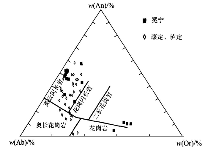
The Kangding Group, outcropping around the northern segment of the western Yangtze craton, has been regarded as a typical Archean high-grade terrain for a long time. The Kangding-Luding and Mianning complexes are representatives of the group. An Sm-Nd isochron of 706 Ma was first obtained through the systematic determination of Sm Nd isotopic composition in the amphibolites-TTG gneisses from the Shaba, Mianning county, Sichuan Province. The isochron and Nd depleted mantle model ages of other samples show that the complexes were metamorphic and anatectic products of Neoproterozoic-mafic-ultra-mafic rocks after breakup of Rodinia by a mantle plume. All these evidences suggest that the present outcropping basements of the Yangtze craton are free of a united evolutionary history. Therefore, further study should be made of the basements of the Yangtze craton.
The Kangding Group, outcropping around the northern segment of the western Yangtze craton, has been regarded as a typical Archean high-grade terrain for a long time. The Kangding-Luding and Mianning complexes are representatives of the group. An Sm-Nd isochron of 706 Ma was first obtained through the systematic determination of Sm Nd isotopic composition in the amphibolites-TTG gneisses from the Shaba, Mianning county, Sichuan Province. The isochron and Nd depleted mantle model ages of other samples show that the complexes were metamorphic and anatectic products of Neoproterozoic-mafic-ultra-mafic rocks after breakup of Rodinia by a mantle plume. All these evidences suggest that the present outcropping basements of the Yangtze craton are free of a united evolutionary history. Therefore, further study should be made of the basements of the Yangtze craton.


2001, 26(3): 286-290.
Abstract:
The Yinggehai and Qiongdongnan basins, often called Ying-Qiong basin, are quite different in their petroleum accumulations. The Tertiary and Quaternary sediments in the Yinggehai basin is up to 17 km thick, with the Oligocene Yacheng and Lingshui formations over-mature. Therefore, the effective source rocks are the Sanya and Meishan formations. The main source rocks in the Qiongdongnan basin are the Yacheng and Lingshui formations. Although both basins are overpressured, their fluid flows are greatly different. The combination of strong overpressure and tensile stress field caused by the right-lateral slipping movement has led both to the fractures in the top layers of the over-pressure systems and to the occurrences of diapirs, an expulsion pathway for the overpressured fluids including natural gases. The fluid flow in the Qiongdongnan basin, however, is compaction driven, and laterally dispersed from the deep depression towards its surrounding areas with a relatively low fluid potential. Traps associated with diapirs are regarded as important exploration targets in the Yinggehai basin, whereas the Neogene lithological-structural complex traps with the excellent pathways to the Oligocene source rocks or the Oligocene structural traps should be considered as the main exploration targets in the Qiongdongnan basin.
The Yinggehai and Qiongdongnan basins, often called Ying-Qiong basin, are quite different in their petroleum accumulations. The Tertiary and Quaternary sediments in the Yinggehai basin is up to 17 km thick, with the Oligocene Yacheng and Lingshui formations over-mature. Therefore, the effective source rocks are the Sanya and Meishan formations. The main source rocks in the Qiongdongnan basin are the Yacheng and Lingshui formations. Although both basins are overpressured, their fluid flows are greatly different. The combination of strong overpressure and tensile stress field caused by the right-lateral slipping movement has led both to the fractures in the top layers of the over-pressure systems and to the occurrences of diapirs, an expulsion pathway for the overpressured fluids including natural gases. The fluid flow in the Qiongdongnan basin, however, is compaction driven, and laterally dispersed from the deep depression towards its surrounding areas with a relatively low fluid potential. Traps associated with diapirs are regarded as important exploration targets in the Yinggehai basin, whereas the Neogene lithological-structural complex traps with the excellent pathways to the Oligocene source rocks or the Oligocene structural traps should be considered as the main exploration targets in the Qiongdongnan basin.


2001, 26(3): 291-296.
Abstract:
The present water-resources assessment for northwestern China is based on such hydrogeological concept model: (1) A barrier resisting water exists between mountains as a main source of runoff and basin; (2) Almost all groundwaters generated in mountain area are converged into the river outflowing from the mountain to the oasis of the basin. The data of groundwater chemistry and isotope and geologic survey show that this model does not conform with the actual hydrogeologic situation. Based on the result of numerical simulation for generating runoff in high mountain area obtained in foreign countries, an analogue method is suggested to estimate roughly the quantity recharged laterally from mountain to oasis of basin through the basement. The construction of this new concept model may reveal the fact that a considerable quantity of water resources are buried in shallow basement rocks in the oasis of mountain-basin systems in northwestern China, which have never been counted in the reserves before.
The present water-resources assessment for northwestern China is based on such hydrogeological concept model: (1) A barrier resisting water exists between mountains as a main source of runoff and basin; (2) Almost all groundwaters generated in mountain area are converged into the river outflowing from the mountain to the oasis of the basin. The data of groundwater chemistry and isotope and geologic survey show that this model does not conform with the actual hydrogeologic situation. Based on the result of numerical simulation for generating runoff in high mountain area obtained in foreign countries, an analogue method is suggested to estimate roughly the quantity recharged laterally from mountain to oasis of basin through the basement. The construction of this new concept model may reveal the fact that a considerable quantity of water resources are buried in shallow basement rocks in the oasis of mountain-basin systems in northwestern China, which have never been counted in the reserves before.


2001, 26(3): 297-303.
Abstract:
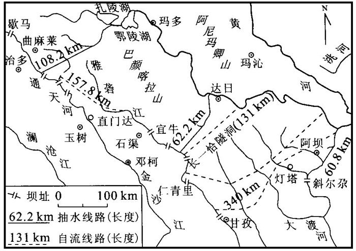
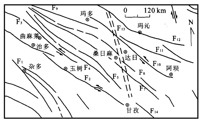
Situated in the north-east of the Tibet plateau where neo-tectonic activity is violent, the west-line project of water diversion from the upper Yangtze River into the upper Yellow River is to divert water by means of long deep-lying tunnels cut across the Bayanhar mountain. The main geological hazards in the project region include the damages from active faults and earthquakes, destructiveness of frozen ground, high ground stress and rock blasting, geo-temperature anomaly, and bank deformation in the reservoir. The most serious geological hazards are the fault activities and earthquakes. This paper discusses the major features and destructive forms caused by the hazards, and presents some measures to deal with these geological hazards.
Situated in the north-east of the Tibet plateau where neo-tectonic activity is violent, the west-line project of water diversion from the upper Yangtze River into the upper Yellow River is to divert water by means of long deep-lying tunnels cut across the Bayanhar mountain. The main geological hazards in the project region include the damages from active faults and earthquakes, destructiveness of frozen ground, high ground stress and rock blasting, geo-temperature anomaly, and bank deformation in the reservoir. The most serious geological hazards are the fault activities and earthquakes. This paper discusses the major features and destructive forms caused by the hazards, and presents some measures to deal with these geological hazards.

2001, 26(3): 304-308.
Abstract:
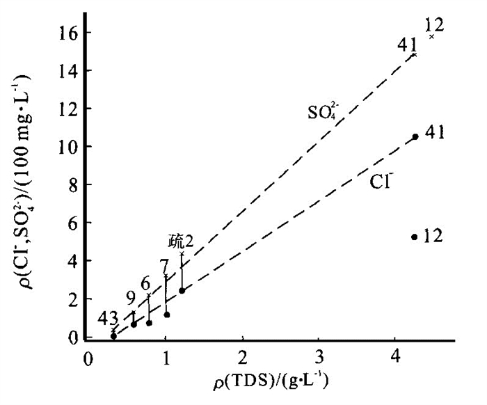
Field and laboratory investigations indicate that organic contaminants have polluted the groundwater and the contaminated area is extending further to the southern part of the Henan Oilfield. Based on the relationship among total oil, inorganic components (such as sulphate, dissolved iron and manganese), and chemical composition of aquifer matrix along the groundwater flow path, sulphate, dissolved iron and manganese are inferred as geochemical indicators of organic contamination of groundwater. The organic contaminants are degraded rapidly in the aquifer where the content of iron and manganese of aquifer matrix is high. The reduction of ferric and manganese oxyhydroxides has resulted in the lack of the iron and manganese in the aquifer and the accumulation of dissolved iron and manganese in the groundwater. In contrast, the organic pollutants are degraded slowly where the content of ferric and manganese oxyhydroxides of aquifer matrix is low, and so are the concentrations of dissolved iron and manganese of groundwater. Besides, the reduction of sulfate has led to the decrease in the sulfate concentration of groundwater and dissolved iron is more sensitive to the organic contaminants than manganese.
Field and laboratory investigations indicate that organic contaminants have polluted the groundwater and the contaminated area is extending further to the southern part of the Henan Oilfield. Based on the relationship among total oil, inorganic components (such as sulphate, dissolved iron and manganese), and chemical composition of aquifer matrix along the groundwater flow path, sulphate, dissolved iron and manganese are inferred as geochemical indicators of organic contamination of groundwater. The organic contaminants are degraded rapidly in the aquifer where the content of iron and manganese of aquifer matrix is high. The reduction of ferric and manganese oxyhydroxides has resulted in the lack of the iron and manganese in the aquifer and the accumulation of dissolved iron and manganese in the groundwater. In contrast, the organic pollutants are degraded slowly where the content of ferric and manganese oxyhydroxides of aquifer matrix is low, and so are the concentrations of dissolved iron and manganese of groundwater. Besides, the reduction of sulfate has led to the decrease in the sulfate concentration of groundwater and dissolved iron is more sensitive to the organic contaminants than manganese.


2001, 26(3): 309-313.
Abstract:
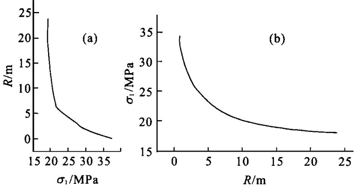
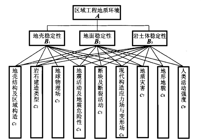
The intersection between Sichuan and Yunnan Provinces through which flows the Jinshajiang River, is a typical active tectonic zone in southwestern China. In this intersection zone, occur strong neotectonic activities accompanied by various endogenic and ectodynamic geological hazards. In this case, the engineering geological environmental system in this region should be evaluated in the planning of the Jinshajiang hydroelectrical gradient project. In this paper, nine factors closely related to the engineering geological environment are chosen to establish a hierarchical analysis model in terms of crust stability, ground stability, and rock and soil mass stability. The factor weighing values obtained from the hierarchical analysis are used to make a comprehensive assessment and zoning of the engineering geological environment quality in the following five categories: poor, relatively poor, normal, relatively good, and good. The zoning of the engineering geological environment indicates that some important engineering geological problems are present in the site selection regions for different gradient engineering projects.
The intersection between Sichuan and Yunnan Provinces through which flows the Jinshajiang River, is a typical active tectonic zone in southwestern China. In this intersection zone, occur strong neotectonic activities accompanied by various endogenic and ectodynamic geological hazards. In this case, the engineering geological environmental system in this region should be evaluated in the planning of the Jinshajiang hydroelectrical gradient project. In this paper, nine factors closely related to the engineering geological environment are chosen to establish a hierarchical analysis model in terms of crust stability, ground stability, and rock and soil mass stability. The factor weighing values obtained from the hierarchical analysis are used to make a comprehensive assessment and zoning of the engineering geological environment quality in the following five categories: poor, relatively poor, normal, relatively good, and good. The zoning of the engineering geological environment indicates that some important engineering geological problems are present in the site selection regions for different gradient engineering projects.


2001, 26(3): 315-321.
Abstract:
Based on the study of a chronosequence of soils, developed from basalts erupted in different geological times, in the northern Hainan island, the variation of soil properties with soil age increasing in its development has been discussed quantitatively. The results show that such soil properties as solum and B horizon thickness, redness rating (RR), w(REE), w(Ba)/w(Nb), w(Fed)/w(Fet), w(Fed), w(Feo)/w(Fed), silica alumina molecular ratio and silica sesquioxide ratio of soils, frequency dependent susceptibility, etc. are definitely correlative to the soil ages. The statistical equations between soil properties and ages have been determined according to pedological principles. When found in the same or similar soil forming environment and regions, relative soil age and soil development degree could be inferred by soil properties which could also be evaluated by soil ages to research rate of soil formation depending on those equations.
Based on the study of a chronosequence of soils, developed from basalts erupted in different geological times, in the northern Hainan island, the variation of soil properties with soil age increasing in its development has been discussed quantitatively. The results show that such soil properties as solum and B horizon thickness, redness rating (RR), w(REE), w(Ba)/w(Nb), w(Fed)/w(Fet), w(Fed), w(Feo)/w(Fed), silica alumina molecular ratio and silica sesquioxide ratio of soils, frequency dependent susceptibility, etc. are definitely correlative to the soil ages. The statistical equations between soil properties and ages have been determined according to pedological principles. When found in the same or similar soil forming environment and regions, relative soil age and soil development degree could be inferred by soil properties which could also be evaluated by soil ages to research rate of soil formation depending on those equations.


2001, 26(3): 323-327.
Abstract:
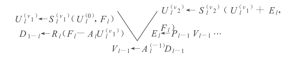
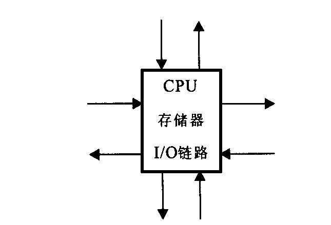
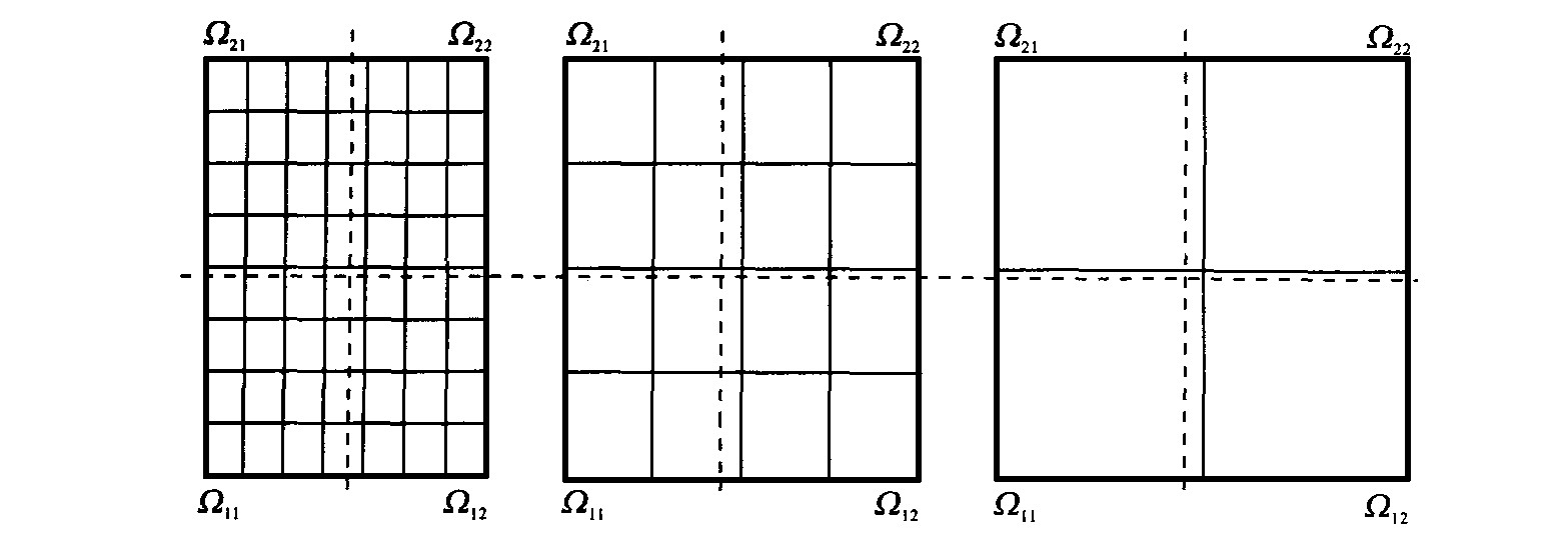
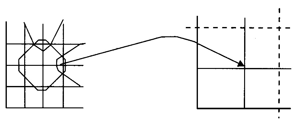
This paper presents the distributed multigrid computation. The sequential algorithm is expressed in a non recursive form. The parallel algorithm is achieved based on domain decomposition. Mesh topology architectures are organized with multiple transputers. Parallel algorithms are mapped onto processes, increasing markedly, to some extent, the speed and efficiency of parallelization.
This paper presents the distributed multigrid computation. The sequential algorithm is expressed in a non recursive form. The parallel algorithm is achieved based on domain decomposition. Mesh topology architectures are organized with multiple transputers. Parallel algorithms are mapped onto processes, increasing markedly, to some extent, the speed and efficiency of parallelization.


2001, 26(3): 328-330.
Abstract:
The atomic and molecular structure parameters Pi and P are defined as: Pi=
The atomic and molecular structure parameters Pi and P are defined as: Pi=
