


2001 Vol. 26, No. 4
Display Method:
2001, 26(4): 331-335.
 PDF 237KB
Abstract:
Information design in engineering geology (IDEG) is a new extension of engineering geology and is of very great significance for optimum design of rock and soil engineering. According to theoretical research and engineering practice, we put forward some theories of IDEG in this paper. The principles and methods of IDEG are introduced and the working steps of information design are deduced. The techniques used in information design, i. e., the network simulation of fractures in rock mass, numerical simulation and geophysical information system (GIS) and key technique are discussed systematically. Finally, taking Dawu slope engineering of Jingzhu highway as an example, we have introduced the process and the steps of IDEG in detail, which shows that IDEG has many advantages in engineering operation.
Information design in engineering geology (IDEG) is a new extension of engineering geology and is of very great significance for optimum design of rock and soil engineering. According to theoretical research and engineering practice, we put forward some theories of IDEG in this paper. The principles and methods of IDEG are introduced and the working steps of information design are deduced. The techniques used in information design, i. e., the network simulation of fractures in rock mass, numerical simulation and geophysical information system (GIS) and key technique are discussed systematically. Finally, taking Dawu slope engineering of Jingzhu highway as an example, we have introduced the process and the steps of IDEG in detail, which shows that IDEG has many advantages in engineering operation.


2001, 26(4): 336-339.
Abstract:
A single prospecting method cannot satisfy the requirement of high level, high quality and high efficiency in a survey. While the application of the comprehensive geological methods: drilling, seismic, gravity and magnetic explorations, TV logging and sound logging, in Junshan Yangtze bridge, Wuhan not only resulted in an accurate prospecting of the weathering of the rocks, the positions of the fissures, their occurrences and scale, etc, which provided the mechanical parameters of the rocks, but also shorted the period of the exploration and thus reduced the cost of the project.
A single prospecting method cannot satisfy the requirement of high level, high quality and high efficiency in a survey. While the application of the comprehensive geological methods: drilling, seismic, gravity and magnetic explorations, TV logging and sound logging, in Junshan Yangtze bridge, Wuhan not only resulted in an accurate prospecting of the weathering of the rocks, the positions of the fissures, their occurrences and scale, etc, which provided the mechanical parameters of the rocks, but also shorted the period of the exploration and thus reduced the cost of the project.


2001, 26(4): 340-342.
Abstract:
Three Gorges Reservoir Area belongs to middle and low-relief terrain, where gulch cutting is deep and dense. The road and railway construction will create large amount of excavation slope and tunnel piercing, which will introduce several environment geology problems, including the slope failure, tunnel collapse and groundwater drainage. With the reservoir development, not only does the inundated road need repair, but also the construction of a new road. So, preventing the geological hazard is of great significance for the protection in the reservoir area. Based on the analysis of the various examples of geological environment problems, the environment geology prediction and prevention techniques were advanced, which provided valuable geological data for the sustainable development in the Three Gorges Reservoir Area.
Three Gorges Reservoir Area belongs to middle and low-relief terrain, where gulch cutting is deep and dense. The road and railway construction will create large amount of excavation slope and tunnel piercing, which will introduce several environment geology problems, including the slope failure, tunnel collapse and groundwater drainage. With the reservoir development, not only does the inundated road need repair, but also the construction of a new road. So, preventing the geological hazard is of great significance for the protection in the reservoir area. Based on the analysis of the various examples of geological environment problems, the environment geology prediction and prevention techniques were advanced, which provided valuable geological data for the sustainable development in the Three Gorges Reservoir Area.
2001, 26(4): 343-346.
Abstract:
By ways of 3S (GPS, GIS, RS), geodesy, geophysics exploration and field testing, main geological problems, such as soft base, concealed fault and area stability, are solved effectively. It has proved that the comprehensive exploration model is better than traditional prospecting, and that it will propell the exploration into standardization, digitization and automation. Moreover, the investment and return period could be reduced to a great extent.
By ways of 3S (GPS, GIS, RS), geodesy, geophysics exploration and field testing, main geological problems, such as soft base, concealed fault and area stability, are solved effectively. It has proved that the comprehensive exploration model is better than traditional prospecting, and that it will propell the exploration into standardization, digitization and automation. Moreover, the investment and return period could be reduced to a great extent.
2001, 26(4): 347-351.
Abstract:
With the development of the highway in mountainous areas, the problem of slope engineering rock mass is increasingly manifold in many different ways. For the sake of recognizing the characters of excavation engineering rock mass in nature, the authors, who, based on the unloading rock mass mechanics, discuss the deformation and destruction characters, the methods of stability analysis and the design theories of the slope engineering rock mass. The research results indicate that the characters of deformation and destruction of the slope are not the same as those of the regular loading rock activities, but conforms with those of unloading rock mass mechanical activities. While the stability analysis of slope rock mass emphasizes hydraulics and unloading effect, and some essential expressions are obtained. It is assumed that the excavation design of the slope engineering rock mass will acquire cost efficiency and optimization only if it is worked out based on sufficient recognition of the engineering mechanics with the consideration of the geological characters and all kinds of data available for the stable slopes.
With the development of the highway in mountainous areas, the problem of slope engineering rock mass is increasingly manifold in many different ways. For the sake of recognizing the characters of excavation engineering rock mass in nature, the authors, who, based on the unloading rock mass mechanics, discuss the deformation and destruction characters, the methods of stability analysis and the design theories of the slope engineering rock mass. The research results indicate that the characters of deformation and destruction of the slope are not the same as those of the regular loading rock activities, but conforms with those of unloading rock mass mechanical activities. While the stability analysis of slope rock mass emphasizes hydraulics and unloading effect, and some essential expressions are obtained. It is assumed that the excavation design of the slope engineering rock mass will acquire cost efficiency and optimization only if it is worked out based on sufficient recognition of the engineering mechanics with the consideration of the geological characters and all kinds of data available for the stable slopes.


2001, 26(4): 352-356.
Abstract:
In order to improve the theory of design and calculation about prestressed anchor cable-pile, save the cost of the project and determine the prestressed anchor cable-pile, according to the theorie of flexural strain on cantilever beam and beam on elastic foundation, the dividing-segment method and the method of subgrade reaction coefficient are used to calculate the strain and internal force of a pile when the deformation between the prestressed anchor and the pile reaches concordance. The deformation of the anchor cable pile is controlled and the internal force distribution along the pile is improved, so as to determine the anchor cable-pile radius, the prestressed value and anchor length. According to the variation of the pile's internal force, the methods of limiting state is used to make bilateral reinforcement through bending moment. Several successful cases show that the above approach is valid for practical use.
In order to improve the theory of design and calculation about prestressed anchor cable-pile, save the cost of the project and determine the prestressed anchor cable-pile, according to the theorie of flexural strain on cantilever beam and beam on elastic foundation, the dividing-segment method and the method of subgrade reaction coefficient are used to calculate the strain and internal force of a pile when the deformation between the prestressed anchor and the pile reaches concordance. The deformation of the anchor cable pile is controlled and the internal force distribution along the pile is improved, so as to determine the anchor cable-pile radius, the prestressed value and anchor length. According to the variation of the pile's internal force, the methods of limiting state is used to make bilateral reinforcement through bending moment. Several successful cases show that the above approach is valid for practical use.

2001, 26(4): 357-360.
Abstract:
The anchor-shotcrete reinforcement has been more and more applied in rockslopes. However, there are some problems in the application, because of the lack of rules about designs and constructions of this type of reinforcement. The paper analyzes some breaking features in rockslopes and anchor-shotcrete reinforcement mechanism together with some problems in the design.
The anchor-shotcrete reinforcement has been more and more applied in rockslopes. However, there are some problems in the application, because of the lack of rules about designs and constructions of this type of reinforcement. The paper analyzes some breaking features in rockslopes and anchor-shotcrete reinforcement mechanism together with some problems in the design.


2001, 26(4): 361-364.
Abstract:
Karst is the main geological problem in southern Hubei section of Beijing-Zhuhai Speedway. This paper has put forward a comprehensive geological method of engineering mapping, engineering geophysics and drilling based on the analysis and the study of the geological background, development factors and degrees. With this method, the spatial distribution characteristics of the karst, and its development regularity and relations to the formation of caves have been so clearly explored that this has provided correct and precise parameters for the design.
Karst is the main geological problem in southern Hubei section of Beijing-Zhuhai Speedway. This paper has put forward a comprehensive geological method of engineering mapping, engineering geophysics and drilling based on the analysis and the study of the geological background, development factors and degrees. With this method, the spatial distribution characteristics of the karst, and its development regularity and relations to the formation of caves have been so clearly explored that this has provided correct and precise parameters for the design.
2001, 26(4): 365-367.
Abstract:
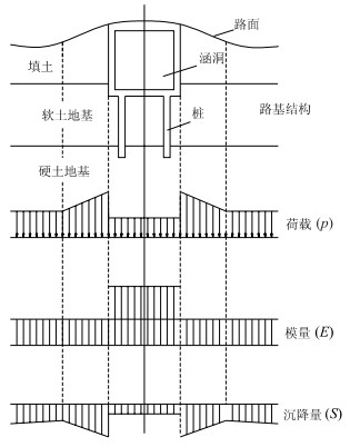
Based on the designing principle of settlement deformation control, settlement fitting has been adopted to resolve the differential settlements between small bridge abutment and bridge culvert in softsoil areas.
Based on the designing principle of settlement deformation control, settlement fitting has been adopted to resolve the differential settlements between small bridge abutment and bridge culvert in softsoil areas.


2001, 26(4): 368-372.
Abstract:
To provide scientific data for the design and construction, this paper evaluates in detail the existing or potential geologic hazards in the soft soil, swelling soil, liquefaction of sand, karst, deep cut, tall subgrade, and road building materials within the northeast area of the highway round Wuhan city. Various investigations and testing means (such as engineering geologic survey, drilling, penetration tests, geophysical exploration, testing and analysis) are used to compute and analyze all the engineering geologic problems and their harm on the highway, to forecast potential geotechnical problems during constructing and after completion, and to offer preventive measures and reasonable construction method.
To provide scientific data for the design and construction, this paper evaluates in detail the existing or potential geologic hazards in the soft soil, swelling soil, liquefaction of sand, karst, deep cut, tall subgrade, and road building materials within the northeast area of the highway round Wuhan city. Various investigations and testing means (such as engineering geologic survey, drilling, penetration tests, geophysical exploration, testing and analysis) are used to compute and analyze all the engineering geologic problems and their harm on the highway, to forecast potential geotechnical problems during constructing and after completion, and to offer preventive measures and reasonable construction method.

2001, 26(4): 373-376.
Abstract:
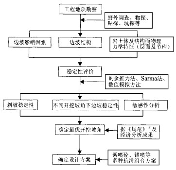
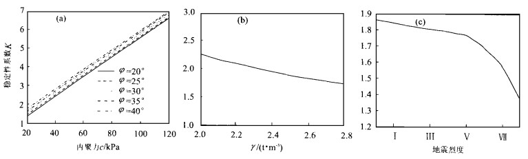
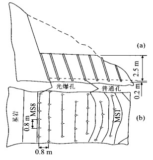
It is known that the stability of the bedding slope of expressways directly affects the running safety of road, so it is important to summarize its characteristics and determine its study methods. Thus this paper presents a summary of its characteristics and an optimum design method and clue for field investigation, stability evaluation, determination of the optimum excavation slope angle and slope improving design. Then, taking the southern part of Dawu Section of Jingzhu (Beijing-Zhuhai) expressway as an example, we discuss the application of this optimum design method. Namely, the slope stability is evaluated with the method of residual pushing force and the Sarma method based on the analysis of the engineering geology conditions. After that, the sensitivity analysis for the slope stability is done using the residual pushing force method. On the precondition of ensuring the whole stability of slope and the economic reasonability, the paper also advances the optimum angle of design, the slope excavation scheme and the anchor and spray concrete scheme of the slope improvement design. The example shows that this optimum design method and clue are systematic and practicable for the construction.
It is known that the stability of the bedding slope of expressways directly affects the running safety of road, so it is important to summarize its characteristics and determine its study methods. Thus this paper presents a summary of its characteristics and an optimum design method and clue for field investigation, stability evaluation, determination of the optimum excavation slope angle and slope improving design. Then, taking the southern part of Dawu Section of Jingzhu (Beijing-Zhuhai) expressway as an example, we discuss the application of this optimum design method. Namely, the slope stability is evaluated with the method of residual pushing force and the Sarma method based on the analysis of the engineering geology conditions. After that, the sensitivity analysis for the slope stability is done using the residual pushing force method. On the precondition of ensuring the whole stability of slope and the economic reasonability, the paper also advances the optimum angle of design, the slope excavation scheme and the anchor and spray concrete scheme of the slope improvement design. The example shows that this optimum design method and clue are systematic and practicable for the construction.


2001, 26(4): 377-380.
Abstract:
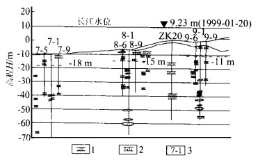
Since the 90s, 20th century, the construction of big traffic bridges across middle-lower reaches of the Changjiang River has stepped into fast development. So far, bridges in Huangshi, Tongling, Jiangyin, Wuhan, and Nanjing have been in transport service. Still, some bridges are under construction and design. Various engineering geological problems have occurred, such as fault, soft interlayers, extreme softrocks, karst caves, and so on. In addition to common methods of investigation and mechanical test, the rheology test of softrocks, color video recordings, the field bearing test, and the pier analogue simulating have been taken to deal with the problems. The practice has provided dependable data for bridge design, which has been proved successful in the construction of bridges, and will be of treasury experience for the future bridge construction in middle-lower reaches of the Changjiang River.
Since the 90s, 20th century, the construction of big traffic bridges across middle-lower reaches of the Changjiang River has stepped into fast development. So far, bridges in Huangshi, Tongling, Jiangyin, Wuhan, and Nanjing have been in transport service. Still, some bridges are under construction and design. Various engineering geological problems have occurred, such as fault, soft interlayers, extreme softrocks, karst caves, and so on. In addition to common methods of investigation and mechanical test, the rheology test of softrocks, color video recordings, the field bearing test, and the pier analogue simulating have been taken to deal with the problems. The practice has provided dependable data for bridge design, which has been proved successful in the construction of bridges, and will be of treasury experience for the future bridge construction in middle-lower reaches of the Changjiang River.


2001, 26(4): 381-384.
Abstract:
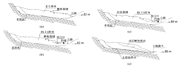
The paper systematically studies different effects of the former and later treatments of Shichengping landslide, which is the largest scale landslide along the first expressway in Guangxi, and its intention is to find out the causes leading to the failure of the former treatment and to form successful experience from the later treatment, making it a reference to other similar projects. It discusses the fundamental features of the landslide in geological, morphological, deformational and structural aspects, and analyzes and compares the former and later treatment designs. The result shows that Shichengping landslide is composed of an ancient and newly formed landslides, the formation of the new one caused by the ancient, and that the failure of the original treatment was due to the improper design because of the unawareness of the ancient landslide, more exactly speaking, mainly because of insufficient length of the anti-slide piles and the improper slope cutting. By making full use of the original anti-slide piles, comprehensive measures of slope cutting, water draining, piles stabilizing the later treatment connects the new piles and the new and old piles with horizontal reinforced concrete beams, which enhances the general stability of the slope and reduces the treatment cost by more than two-million yuan, and the result is satisfactory after four years of testing.
The paper systematically studies different effects of the former and later treatments of Shichengping landslide, which is the largest scale landslide along the first expressway in Guangxi, and its intention is to find out the causes leading to the failure of the former treatment and to form successful experience from the later treatment, making it a reference to other similar projects. It discusses the fundamental features of the landslide in geological, morphological, deformational and structural aspects, and analyzes and compares the former and later treatment designs. The result shows that Shichengping landslide is composed of an ancient and newly formed landslides, the formation of the new one caused by the ancient, and that the failure of the original treatment was due to the improper design because of the unawareness of the ancient landslide, more exactly speaking, mainly because of insufficient length of the anti-slide piles and the improper slope cutting. By making full use of the original anti-slide piles, comprehensive measures of slope cutting, water draining, piles stabilizing the later treatment connects the new piles and the new and old piles with horizontal reinforced concrete beams, which enhances the general stability of the slope and reduces the treatment cost by more than two-million yuan, and the result is satisfactory after four years of testing.


2001, 26(4): 385-387.
Abstract:
The main engineering problems were represented in the paper: developing faults, fold strata and unclear belt of Xiangfan-Guangji fracture. In elementary period, comprehensive geological methods were applied in the exploration of the bridge site at the same depth for different samples. As a result, no belt of Xiangfan-Guangji fracture was prospected, and only two faults were found at K80+530 m and K81+860 m. The F1 fault of them had a great influence on the three-tower rope scheme, while the F2 fault in the south bridge approach had little. So, the scheme of rope bridge was better if only geological conditions were considered. If the sample of stiff bridge was selected, the middle tower must be moved to the south.
The main engineering problems were represented in the paper: developing faults, fold strata and unclear belt of Xiangfan-Guangji fracture. In elementary period, comprehensive geological methods were applied in the exploration of the bridge site at the same depth for different samples. As a result, no belt of Xiangfan-Guangji fracture was prospected, and only two faults were found at K80+530 m and K81+860 m. The F1 fault of them had a great influence on the three-tower rope scheme, while the F2 fault in the south bridge approach had little. So, the scheme of rope bridge was better if only geological conditions were considered. If the sample of stiff bridge was selected, the middle tower must be moved to the south.
2001, 26(4): 388-390.
Abstract:
The engineering problems were very complex at the site of Yangluo bridge: developing faults, fold strata and the unclear belt of Xiangfan-Guangji fracture. With the methods of reflection-seismic exploration and mapping-seismic exploration, the geological conditions and the strata lithology are prospected clearly. At the same time the evaluation is made of its engineering geological conditions for selecting bridge scheme.
The engineering problems were very complex at the site of Yangluo bridge: developing faults, fold strata and the unclear belt of Xiangfan-Guangji fracture. With the methods of reflection-seismic exploration and mapping-seismic exploration, the geological conditions and the strata lithology are prospected clearly. At the same time the evaluation is made of its engineering geological conditions for selecting bridge scheme.


2001, 26(4): 391-394.
Abstract:
In this paper the geomechanical model test is used to analyze the foundation stability and failure mechanism of the south pier of Jiangyin Yangtze bridge. The test results indicate that its settlement remains a main problem since there is no opening boundary. Overloaded 2.2 times more than the design and the slope angle increased 5.3 degree, failure did not occur, which ensures the stability of the pier foundation.
In this paper the geomechanical model test is used to analyze the foundation stability and failure mechanism of the south pier of Jiangyin Yangtze bridge. The test results indicate that its settlement remains a main problem since there is no opening boundary. Overloaded 2.2 times more than the design and the slope angle increased 5.3 degree, failure did not occur, which ensures the stability of the pier foundation.


2001, 26(4): 395-397.
Abstract:
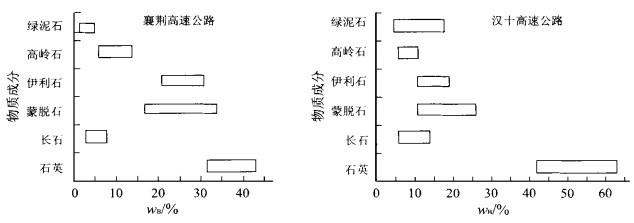
Swell dilatability is the main geological problem in Xiangjing and Hanshi highway project. By X-ray diffraction and grain analyses, higher contents of ascanite and illite were found in the former highway, but the content of quartz, feldspar and chlorite are found low. The swell dilatability in the two highway sites were the same, low or middle level, but the difference in the content of clay minerals resulted in the higher swell dilatability in Xiangjing highway site. Moreover, the sedimentation quantity in 50 kPa was larger than its dilatability.
Swell dilatability is the main geological problem in Xiangjing and Hanshi highway project. By X-ray diffraction and grain analyses, higher contents of ascanite and illite were found in the former highway, but the content of quartz, feldspar and chlorite are found low. The swell dilatability in the two highway sites were the same, low or middle level, but the difference in the content of clay minerals resulted in the higher swell dilatability in Xiangjing highway site. Moreover, the sedimentation quantity in 50 kPa was larger than its dilatability.

2001, 26(4): 398-401.
Abstract:
Based on the exploration data of engineering geology, and by means of geological method and the analysis of mathematical statistics of test parameters, polus morphism project figures as well as the analysis of a typical engineering case, the main characteristics of the rock types and the factors affecting the stability of the tunnel wall rocks are studied, which makes a conclusion that the collapse is the major engineering geology problem in the tunnel engineering and that the development of the schistosity in the vein body fringe and cracks and precipitation significantly affect the stability of tunnel wall rocks.
Based on the exploration data of engineering geology, and by means of geological method and the analysis of mathematical statistics of test parameters, polus morphism project figures as well as the analysis of a typical engineering case, the main characteristics of the rock types and the factors affecting the stability of the tunnel wall rocks are studied, which makes a conclusion that the collapse is the major engineering geology problem in the tunnel engineering and that the development of the schistosity in the vein body fringe and cracks and precipitation significantly affect the stability of tunnel wall rocks.
2001, 26(4): 402-405.
Abstract:
When the Three Gorges Engineering has been finished, the road along both banks in the reservoir area of the Changjiang River flooded by reservoir water is about 1 000 kilometers long, which requires the rebuilding of the flooded roads and also the construction of many new roads. This paper discusses the major geological hazards of the rebuilding engineering in the Three Gorges Engineering reservoir area with an example. It points out that the hazards mainly take place in such places as slopes, collapse, and debris flows, as often as those in the mountain area. While the latent geological disasters are the disadvantageous effect on the road engineering due to the reservoir bank rebuilding. At the same time the paper also analyzes the reasons for the disasters and presents some countermeasures. The idea presented in the paper is available for reference in the road construction in the Three Gorges Engineering reservoir area and other areas with similar geological conditions.
When the Three Gorges Engineering has been finished, the road along both banks in the reservoir area of the Changjiang River flooded by reservoir water is about 1 000 kilometers long, which requires the rebuilding of the flooded roads and also the construction of many new roads. This paper discusses the major geological hazards of the rebuilding engineering in the Three Gorges Engineering reservoir area with an example. It points out that the hazards mainly take place in such places as slopes, collapse, and debris flows, as often as those in the mountain area. While the latent geological disasters are the disadvantageous effect on the road engineering due to the reservoir bank rebuilding. At the same time the paper also analyzes the reasons for the disasters and presents some countermeasures. The idea presented in the paper is available for reference in the road construction in the Three Gorges Engineering reservoir area and other areas with similar geological conditions.


2001, 26(4): 406-409.
Abstract:
The rock strength is one of the main problems related to the pier foundation of the second Nanjing bridge across the Changjiang River. Poor cementation of conglomerate with sandy conglomerate and wide range of gravel diameters make it difficult to sample and to test by the conventional methods. A thorough geological investigation having been carried out and field tests conducted some mechanical parameters are suggested in this paper. Our work has provided a dependable basis for optimization design of the bridge piers.
The rock strength is one of the main problems related to the pier foundation of the second Nanjing bridge across the Changjiang River. Poor cementation of conglomerate with sandy conglomerate and wide range of gravel diameters make it difficult to sample and to test by the conventional methods. A thorough geological investigation having been carried out and field tests conducted some mechanical parameters are suggested in this paper. Our work has provided a dependable basis for optimization design of the bridge piers.

2001, 26(4): 410-414.
Abstract:
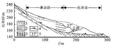
The Badong Yangtze Bridge is a large-sized road bridge across the Yangtze River, linking the No.209 national highway. It lies in middle part of the Three Gorges where geotechnical condition is the most complex. In the bridge area, the landform is cliffy; the valley incised sharply; and the geo-structure is complicated with the rock mass heavily cracked. While landslides and debris-flows are particularly common. By rock structure simulation, the rock discontinuity net and the RQD distributing figure were obtained. Moreover, the slope and groundsill stability about the bridge were analyzed systemically by the elastic-plastic finite element method and plot utmost balance way. At the same time, the influences of the aired and the fractured rockmass on the bridge were discussed. Based on the above, proposals have been made about the pier foundation style, the picket ground's depth and carrying strength. At last, more suggestions for the slope remedy have been put forward.
The Badong Yangtze Bridge is a large-sized road bridge across the Yangtze River, linking the No.209 national highway. It lies in middle part of the Three Gorges where geotechnical condition is the most complex. In the bridge area, the landform is cliffy; the valley incised sharply; and the geo-structure is complicated with the rock mass heavily cracked. While landslides and debris-flows are particularly common. By rock structure simulation, the rock discontinuity net and the RQD distributing figure were obtained. Moreover, the slope and groundsill stability about the bridge were analyzed systemically by the elastic-plastic finite element method and plot utmost balance way. At the same time, the influences of the aired and the fractured rockmass on the bridge were discussed. Based on the above, proposals have been made about the pier foundation style, the picket ground's depth and carrying strength. At last, more suggestions for the slope remedy have been put forward.


2001, 26(4): 415-418.
Abstract:
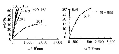
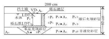
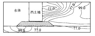
The field investigation found that seismic damage to gravity-type quay walls during Kobe earthquake consisted of tremendous lateral displacement of retaining walls. It is very important to clarify the mechanism of the wall displacement in order to improve the aseismatic design. For this purpose, a model of gravity-type quay wall ground based on the principle of similitude was designed and a series of shaking table tests are carried out in present study. The test results indicate that the strength decrease and local liquefaction of subsoil are the leading factors in the deformation and failure of retaining walls. The increase of dynamic earth pressure in the back of structure provides the movement condition for the structure. While the movement of the ground mainly manifest as the lateral displacement under liquefaction and the gravity is the leading factor in the lateral movement. It is very significant that the dynamic earth pressure is decreased and the foundation sand is fully compacted to increase the stability of gravity quay walls during future earthquakes.
The field investigation found that seismic damage to gravity-type quay walls during Kobe earthquake consisted of tremendous lateral displacement of retaining walls. It is very important to clarify the mechanism of the wall displacement in order to improve the aseismatic design. For this purpose, a model of gravity-type quay wall ground based on the principle of similitude was designed and a series of shaking table tests are carried out in present study. The test results indicate that the strength decrease and local liquefaction of subsoil are the leading factors in the deformation and failure of retaining walls. The increase of dynamic earth pressure in the back of structure provides the movement condition for the structure. While the movement of the ground mainly manifest as the lateral displacement under liquefaction and the gravity is the leading factor in the lateral movement. It is very significant that the dynamic earth pressure is decreased and the foundation sand is fully compacted to increase the stability of gravity quay walls during future earthquakes.


2001, 26(4): 419-423.
Abstract:
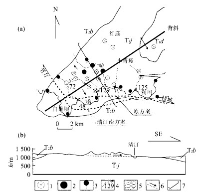
It is very important to choose the right controlling line scheme as the engineering geological conditions are very complicated in Zhicheng-Wanxian railway. The paper analyzes the geological background in the area and summarizes its characteristics and laws of engineering geology and hydrogeology and finally figures out the key geological problems of controlling line scheme in order to determine the principles of the engineering geological locations and the direction of alternative scheme.
It is very important to choose the right controlling line scheme as the engineering geological conditions are very complicated in Zhicheng-Wanxian railway. The paper analyzes the geological background in the area and summarizes its characteristics and laws of engineering geology and hydrogeology and finally figures out the key geological problems of controlling line scheme in order to determine the principles of the engineering geological locations and the direction of alternative scheme.


2001, 26(4): 424-428.
Abstract:
Based on the situation of large-scale distribution of swell soil along Dangyang-Yichang speedway, the paper presents the studies on the swelling soil test and stability analysis. In order to optimize the reinforcement measures, to avoid slope movement, rock-fall as well, it further discusses the properties of swell soil and the stability of foundation so as to find the remedial measures.
Based on the situation of large-scale distribution of swell soil along Dangyang-Yichang speedway, the paper presents the studies on the swelling soil test and stability analysis. In order to optimize the reinforcement measures, to avoid slope movement, rock-fall as well, it further discusses the properties of swell soil and the stability of foundation so as to find the remedial measures.
2001, 26(4): 429-432.
Abstract:
The swell soil landslide in Xianshanya area, Xiangfan, Hubei Province, is disastrous on the traffic. Plenty of funds have been invested to solve the problem but have not produced any good result. This is perhaps mainly due to the lack of understanding of the swell soil. Based on some characters of the landslide, the X-ray diffraction (XRD) and X-ray fluorescent (XRF) spectrum and scan electron microscope (SEM) are used to study the physical properties and the microstructure of the swell soil of landslide. Then, the effect of some characters in the formation and evolvement of the swell soil landslide is discussed with more illustration of the landslide formation mechanism. Meanwhile, some important rules of the swell soil of landslide are summed up combined with this area's geological conditions. This may serve as some references for the prevention in the swell soil area.
The swell soil landslide in Xianshanya area, Xiangfan, Hubei Province, is disastrous on the traffic. Plenty of funds have been invested to solve the problem but have not produced any good result. This is perhaps mainly due to the lack of understanding of the swell soil. Based on some characters of the landslide, the X-ray diffraction (XRD) and X-ray fluorescent (XRF) spectrum and scan electron microscope (SEM) are used to study the physical properties and the microstructure of the swell soil of landslide. Then, the effect of some characters in the formation and evolvement of the swell soil landslide is discussed with more illustration of the landslide formation mechanism. Meanwhile, some important rules of the swell soil of landslide are summed up combined with this area's geological conditions. This may serve as some references for the prevention in the swell soil area.
2001, 26(4): 433-436.
Abstract:
The major trunk of the Shanghai-Chengdu National highway from Wushan to Wanzhou segment is located in Sichuan Province paralleling to the northern bank of the Yangtze River. Great topographic reliefs, poor geology and special geology phenomena are seen to exist in the area. In order to ascertain scope of poor geology in the areas and offer basic geologic data, remote sensing technique in the feasible research of the area is used, which has yielded good results.
The major trunk of the Shanghai-Chengdu National highway from Wushan to Wanzhou segment is located in Sichuan Province paralleling to the northern bank of the Yangtze River. Great topographic reliefs, poor geology and special geology phenomena are seen to exist in the area. In order to ascertain scope of poor geology in the areas and offer basic geologic data, remote sensing technique in the feasible research of the area is used, which has yielded good results.

2001, 26(4): 437-440.
Abstract:
The distribution feature of the flood land along the river, its landform and structure, basal structures and hydrologic conditions are analyzed based on the data collected systematically. At the same time, the physical-mechanical properties, including the typical and non-typical flood land soil, are compared according to the difference of the outcrops. The environment engineering geology condition, from the landform feature, stratum structure to unfavorable geology condition, of the harbor construction along the middle and lower reaches of the Yangtze River were evaluated synthetically. On the basis of the study and analysis, the methods of utilizing the good environment condition to keep away from and prevent the unfavorable environment geology condition were advanced, which is valuable for the harbor construction along the middle and lower reaches of the Yangtze River.
The distribution feature of the flood land along the river, its landform and structure, basal structures and hydrologic conditions are analyzed based on the data collected systematically. At the same time, the physical-mechanical properties, including the typical and non-typical flood land soil, are compared according to the difference of the outcrops. The environment engineering geology condition, from the landform feature, stratum structure to unfavorable geology condition, of the harbor construction along the middle and lower reaches of the Yangtze River were evaluated synthetically. On the basis of the study and analysis, the methods of utilizing the good environment condition to keep away from and prevent the unfavorable environment geology condition were advanced, which is valuable for the harbor construction along the middle and lower reaches of the Yangtze River.
