


2001 Vol. 26, No. 5
Display Method:
2001, 26(5): 441-445.
 PDF 552KB
Abstract:
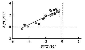
Stable-isotopic analyses of 27 ostracoda samples from oil source rocks in Dongying depression (Bohai Gulf basin, East China) have been carried out. The results show that the δ(18O) of the ostracoda is negative and the δ(13C) is positive except one sample (δ(18O) : -4.853×10⁻³ to -0.341×10⁻³; δ(13C) : -0.360×10⁻³ to 2.961×10⁻³), which displays the characteristics, highly correlated in covariance between oxygen and carbon isotopic variations (r=0.92). This characteristics is similar to the stable oxygen and carbon isotopic compositions of primary carbonates from modern hydrologically closed lakes. Therefore, we concluded that the paleolake during the oil source rocks deposition in Dongying depression is a closed saline or brackish lake. Based on the vertical variation of δ(18O) and δ(13C), the changes of the paleoclimate, paleolake level and paleoproductivity have been discussed. In the early stage of oil source rocks deposition, the climate was dry, the lake level, lower and the productivity, high, but it became wet, and the high water level and lower productivity occurred in the late depositional period.
Stable-isotopic analyses of 27 ostracoda samples from oil source rocks in Dongying depression (Bohai Gulf basin, East China) have been carried out. The results show that the δ(18O) of the ostracoda is negative and the δ(13C) is positive except one sample (δ(18O) : -4.853×10⁻³ to -0.341×10⁻³; δ(13C) : -0.360×10⁻³ to 2.961×10⁻³), which displays the characteristics, highly correlated in covariance between oxygen and carbon isotopic variations (r=0.92). This characteristics is similar to the stable oxygen and carbon isotopic compositions of primary carbonates from modern hydrologically closed lakes. Therefore, we concluded that the paleolake during the oil source rocks deposition in Dongying depression is a closed saline or brackish lake. Based on the vertical variation of δ(18O) and δ(13C), the changes of the paleoclimate, paleolake level and paleoproductivity have been discussed. In the early stage of oil source rocks deposition, the climate was dry, the lake level, lower and the productivity, high, but it became wet, and the high water level and lower productivity occurred in the late depositional period.


2001, 26(5): 449-455.
Abstract:
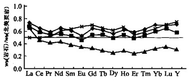
Detailed studies of biostratigraphy and sedimentology of the siliceous rocks from the Muyinhe Formation in the Changning-Menglian belt, Southwest Yunnan indicate that the deposition occurred in a deep-water basin in Middle Triassic. However, its depositional tectonic setting is little understood. The main purpose of this article is to analyze its provenance and depositional tectonic background by using molecular organic geochemistry and inorganic geochemistry. The carbon number distribution of the normal paraffin in the siliceous rock is relatively wide, C14-C36, with two peaks, which implies that this organic matter is derived from both higher terrigenous plants and marine autochthonous organisms. The features of the steroid and terpenoid hydrocarbons suggest that the organic is mainly originated from marine sources mixed with terrigenous sources. The REE characteristics of the siliceous rock are as followed: total w (REE) ranges from 83.56 × 10⁻⁶ to 124.1 × 10⁻⁶, w (Ce)/w (Ce*) between 0.76 and 0.99, w (La)n/w (Yb)n from 0.77 to 1.98. These characteristics show that the basin was apparently influenced by terrigenous sources. In addition, w (MnO)/w (TiO2) ratio and w (La)n/w (Ce)n vs. w (Al2O3)/w (Al2O3+Fe2O3) plot consistently show that the chert was influenced by land sources during its depositional process. While the incorporating characteristics of the organic and inorganic in the siliceous rocks suggest that the studied area was a limited deep-water basin and was strongly influenced by terrigenous matter and that molecular organic geochemistry can provide more information about the provenance and sedimentary environment of siliceous rocks.
Detailed studies of biostratigraphy and sedimentology of the siliceous rocks from the Muyinhe Formation in the Changning-Menglian belt, Southwest Yunnan indicate that the deposition occurred in a deep-water basin in Middle Triassic. However, its depositional tectonic setting is little understood. The main purpose of this article is to analyze its provenance and depositional tectonic background by using molecular organic geochemistry and inorganic geochemistry. The carbon number distribution of the normal paraffin in the siliceous rock is relatively wide, C14-C36, with two peaks, which implies that this organic matter is derived from both higher terrigenous plants and marine autochthonous organisms. The features of the steroid and terpenoid hydrocarbons suggest that the organic is mainly originated from marine sources mixed with terrigenous sources. The REE characteristics of the siliceous rock are as followed: total w (REE) ranges from 83.56 × 10⁻⁶ to 124.1 × 10⁻⁶, w (Ce)/w (Ce*) between 0.76 and 0.99, w (La)n/w (Yb)n from 0.77 to 1.98. These characteristics show that the basin was apparently influenced by terrigenous sources. In addition, w (MnO)/w (TiO2) ratio and w (La)n/w (Ce)n vs. w (Al2O3)/w (Al2O3+Fe2O3) plot consistently show that the chert was influenced by land sources during its depositional process. While the incorporating characteristics of the organic and inorganic in the siliceous rocks suggest that the studied area was a limited deep-water basin and was strongly influenced by terrigenous matter and that molecular organic geochemistry can provide more information about the provenance and sedimentary environment of siliceous rocks.


2001, 26(5): 457-463.
Abstract:
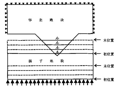
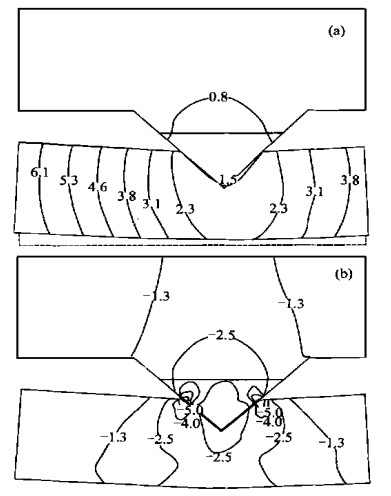
Based on the geological feature and the paleomagnetic evidence of the collision of the North and South China Blocks, a point-collision model for the collision of A-A type is given to study phenomenon of stress concentration in Dabie orogenic belt. By using finite element method, we discuss the effect of tectonic pressure on forming UHP metamorphic rocks and its possible forming depth. The results show that: On the condition of this paper, (1) The initial collision between two continents would cause the tectonic average stress near the collisional point to increase by 5-9 times as compared with regional stress field. Under the 100 MPa boundary force, the proportion of tectonic pressure in UHP is about 20%-35%. (2) For the reason of having action of tectonic pressure, UHP rocks likely form in the depth of 65-80 km. (3) If we solely consider the collision way but not the differences of rock mechanical property and other factors, the influence of tectonic stress is limited and lithostatic pressure will still play a main role in forming UHP metamorphic rocks.
Based on the geological feature and the paleomagnetic evidence of the collision of the North and South China Blocks, a point-collision model for the collision of A-A type is given to study phenomenon of stress concentration in Dabie orogenic belt. By using finite element method, we discuss the effect of tectonic pressure on forming UHP metamorphic rocks and its possible forming depth. The results show that: On the condition of this paper, (1) The initial collision between two continents would cause the tectonic average stress near the collisional point to increase by 5-9 times as compared with regional stress field. Under the 100 MPa boundary force, the proportion of tectonic pressure in UHP is about 20%-35%. (2) For the reason of having action of tectonic pressure, UHP rocks likely form in the depth of 65-80 km. (3) If we solely consider the collision way but not the differences of rock mechanical property and other factors, the influence of tectonic stress is limited and lithostatic pressure will still play a main role in forming UHP metamorphic rocks.


2001, 26(5): 464-472.
Abstract:
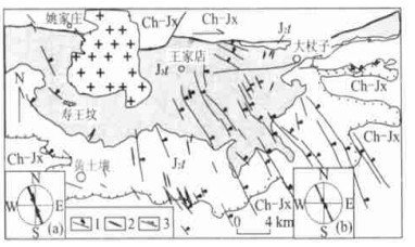
The geometry and inner structures as well as the kinematics of the east-west dextral strike-slip fault system in the middle segment of the intraplate Yanshan orogenic belt are described. The dextral strike-slip fault system is composed of east-west oriented master faults - Gubeikou-Pingquan fault zone and Miyun-Xifengkou fault zone, with the structures between them such as the northeast strike contractional faults and associate folds, northwest oriented extensional faults and dykes as well. The master east-west faults are characterized by subordinate right lateral overstep en echlon faults. While the northwest striking extensional faults and dykes are comparable to "T fractures" expected by Riedel model. The northeast oriented contractional faults and related folds, meanwhile, are the counterparts of compressive structures in Riedel model. The combination of the master faults with the associate northeast fault and folds makes a strike-slip duplex structure. The strike-slip faults formed between later Jurassic and Early Cretaceous. Giving the temporal and spatial relationship among the east-west trending dextral strike-slip fault system and the southeast-ward thrust faulting in the eastern part and the northwestward thrust fault system in the western segment of the Yanshan belt, a unified tectonic model - dextral slip system has been established. This model leads to a renewed interpretation of the tectonic framework and evolution of the Mesozoic-Cenozoic intraplate Yanshan orogenic belt. In this model, the two thrust systems with opposite movement directions in western Liaoning and northwestern Hebei provinces are considered as the result of the compressions in the front of dextral strike-slip plates northeast and southwest of the master fault, respectively. It is reasonable to infer that the tectonic framework of the late Mesozoic intraplate Yanshan orogen is dominated by east-west dextral strike-slip faulting and related deformation. Furthermore, the intraplate Yanshan orogenic belt might be another "extrusion tectonic belt" or "escape tectonics" during the Jura-Cretaceous time in the frame of northeastern Asia. However, a synchronous sinistral strike-slip fault zone north to this belt is needed to prove this interpretation.
The geometry and inner structures as well as the kinematics of the east-west dextral strike-slip fault system in the middle segment of the intraplate Yanshan orogenic belt are described. The dextral strike-slip fault system is composed of east-west oriented master faults - Gubeikou-Pingquan fault zone and Miyun-Xifengkou fault zone, with the structures between them such as the northeast strike contractional faults and associate folds, northwest oriented extensional faults and dykes as well. The master east-west faults are characterized by subordinate right lateral overstep en echlon faults. While the northwest striking extensional faults and dykes are comparable to "T fractures" expected by Riedel model. The northeast oriented contractional faults and related folds, meanwhile, are the counterparts of compressive structures in Riedel model. The combination of the master faults with the associate northeast fault and folds makes a strike-slip duplex structure. The strike-slip faults formed between later Jurassic and Early Cretaceous. Giving the temporal and spatial relationship among the east-west trending dextral strike-slip fault system and the southeast-ward thrust faulting in the eastern part and the northwestward thrust fault system in the western segment of the Yanshan belt, a unified tectonic model - dextral slip system has been established. This model leads to a renewed interpretation of the tectonic framework and evolution of the Mesozoic-Cenozoic intraplate Yanshan orogenic belt. In this model, the two thrust systems with opposite movement directions in western Liaoning and northwestern Hebei provinces are considered as the result of the compressions in the front of dextral strike-slip plates northeast and southwest of the master fault, respectively. It is reasonable to infer that the tectonic framework of the late Mesozoic intraplate Yanshan orogen is dominated by east-west dextral strike-slip faulting and related deformation. Furthermore, the intraplate Yanshan orogenic belt might be another "extrusion tectonic belt" or "escape tectonics" during the Jura-Cretaceous time in the frame of northeastern Asia. However, a synchronous sinistral strike-slip fault zone north to this belt is needed to prove this interpretation.


2001, 26(5): 473-480.
Abstract:
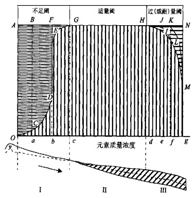
Detailed studies have been conducted of the trace elements in ores, wallrocks of intrusion and orebodies in the Yinshan deposit. It is shown that∑ REE increased in all samples but those close to the intrusion and orebodies decreased.Altered wallrocks are characterized by lower w(LREE)/w(HREE)ratios and depleted in Eu compared with their fresh counterpart. It is suggested by calculation that less much. While E.D.Weinberg expanded the G.Bertrand law and further revealed that certain quantity of manganese may allow some bacteria to grow well but may not be suitable for them to produce bacteriophage. Biologic vital double threshold element content and its physiological effect can be expanded to different hydrogeochemistry zones in hydrogeologic unit. In elements lioxiviated(leached), transferred strongly hydrogeo-chemistry zone, biologic physiological effect and element content show negative correlativity. In elements enrichment, lioxiviated, concentration by evaporation hydrogeochemistry zone and environment polluted by some elements superfluous, biologic physiological negative effect and element content show positive correlativity, between them which above is the element content fitting zone. Take the Lishi-Liulin hydrogeologic unitof Shanxi Province as an instance: The lack of selenium, iodine and fluorine in the hydrochemistry zone with element leaching and loss causes KBD, IDD, and tooth decay, which is in a negative correlativity with element content, respectively. While in the element lioxiviation and enrichment zone, fluorine is superfluous.As a result, endemic fluorosis occurs and its sick rate shows positive correlativity with content.
Detailed studies have been conducted of the trace elements in ores, wallrocks of intrusion and orebodies in the Yinshan deposit. It is shown that∑ REE increased in all samples but those close to the intrusion and orebodies decreased.Altered wallrocks are characterized by lower w(LREE)/w(HREE)ratios and depleted in Eu compared with their fresh counterpart. It is suggested by calculation that less much. While E.D.Weinberg expanded the G.Bertrand law and further revealed that certain quantity of manganese may allow some bacteria to grow well but may not be suitable for them to produce bacteriophage. Biologic vital double threshold element content and its physiological effect can be expanded to different hydrogeochemistry zones in hydrogeologic unit. In elements lioxiviated(leached), transferred strongly hydrogeo-chemistry zone, biologic physiological effect and element content show negative correlativity. In elements enrichment, lioxiviated, concentration by evaporation hydrogeochemistry zone and environment polluted by some elements superfluous, biologic physiological negative effect and element content show positive correlativity, between them which above is the element content fitting zone. Take the Lishi-Liulin hydrogeologic unitof Shanxi Province as an instance: The lack of selenium, iodine and fluorine in the hydrochemistry zone with element leaching and loss causes KBD, IDD, and tooth decay, which is in a negative correlativity with element content, respectively. While in the element lioxiviation and enrichment zone, fluorine is superfluous.As a result, endemic fluorosis occurs and its sick rate shows positive correlativity with content.


2001, 26(5): 481-485.
Abstract:
When studying the biologic adaptability by using biologic vital element-manganese in the laboratory, G.Bertrand found that plant can't live if there is the lack of a certain vital element and that if the element is sufficient enough, the plant may live very well, but it may be poisoned or even die if the element is so much. While E.D.Weinberg expanded the G.Bertrand law and further revealed that certain quantity of manganese may allow some bacteria to grow well but may not be suitable for them to produce bacteriophage. Biologic vital double threshold element content and its physiological effect can be expanded to different hydrogeochemistry zones in hydrogeologic unit. In elements lioxiviated (leached), transferred strongly hydrogeochemistry zone, biologic physiological effect and element content show negative correlativity. In elements enrichment, lioxiviated, concentration by evaporation hydrogeochemistry zone and environment polluted by some elements superfluous, biologic physiological negative effect and element content show positive correlativity, between them which above is the element content fitting zone. Take the Lishi-Liulin hydrogeologic unit of Shanxi Province as an instance: The lack of selenium, iodine and fluorine in the hydrochemistry zone with element leaching and loss causes KBD, IDD, and tooth decay, which is in a negative correlativity with element content, respectively. While in the element lioxiviation and enrichment zone, fluorine is superfluous. As a result, endemic fluorosis occurs and its sick rate shows positive correlativity with content.
When studying the biologic adaptability by using biologic vital element-manganese in the laboratory, G.Bertrand found that plant can't live if there is the lack of a certain vital element and that if the element is sufficient enough, the plant may live very well, but it may be poisoned or even die if the element is so much. While E.D.Weinberg expanded the G.Bertrand law and further revealed that certain quantity of manganese may allow some bacteria to grow well but may not be suitable for them to produce bacteriophage. Biologic vital double threshold element content and its physiological effect can be expanded to different hydrogeochemistry zones in hydrogeologic unit. In elements lioxiviated (leached), transferred strongly hydrogeochemistry zone, biologic physiological effect and element content show negative correlativity. In elements enrichment, lioxiviated, concentration by evaporation hydrogeochemistry zone and environment polluted by some elements superfluous, biologic physiological negative effect and element content show positive correlativity, between them which above is the element content fitting zone. Take the Lishi-Liulin hydrogeologic unit of Shanxi Province as an instance: The lack of selenium, iodine and fluorine in the hydrochemistry zone with element leaching and loss causes KBD, IDD, and tooth decay, which is in a negative correlativity with element content, respectively. While in the element lioxiviation and enrichment zone, fluorine is superfluous. As a result, endemic fluorosis occurs and its sick rate shows positive correlativity with content.


2001, 26(5): 486-490.
Abstract:
This paper illustrats the theory foundation, research steps and method of processing asymmetric analysis on geochemical spatial field with the structure analysis theory as a tool. Taking a part of North Tarim basin as a testing area, the research laid emphasis upon the continuity, anisotropy and regional asymmetry of the geoscientific field. Combined with the geological background and distribution of indices concentration contour, systemic analysis is performed.
This paper illustrats the theory foundation, research steps and method of processing asymmetric analysis on geochemical spatial field with the structure analysis theory as a tool. Taking a part of North Tarim basin as a testing area, the research laid emphasis upon the continuity, anisotropy and regional asymmetry of the geoscientific field. Combined with the geological background and distribution of indices concentration contour, systemic analysis is performed.


2001, 26(5): 491-495.
Abstract:
Xingzi metamorphic core complex" exposed in the Lushan mountain of northern Jiangxi Province is a typical Cordilleran-type metamorphic core complex so far discovered in southeastern China. Numerous pegmatites intruded in the structural weak zone were present in the core of "Xingzi metamorphic core complex", which is contemporaneous with the detachment fault. Zircon U-Pb dating age of the pegmatite is 130 Ma, representing the uplift age of the complex, which is supported by other geological evidences. The possible spatial and temporal links, furthermore, between the complex formation and contemporary extensive Late Mesozoic magmatism in southeastern China are discussed in this paper.
Xingzi metamorphic core complex" exposed in the Lushan mountain of northern Jiangxi Province is a typical Cordilleran-type metamorphic core complex so far discovered in southeastern China. Numerous pegmatites intruded in the structural weak zone were present in the core of "Xingzi metamorphic core complex", which is contemporaneous with the detachment fault. Zircon U-Pb dating age of the pegmatite is 130 Ma, representing the uplift age of the complex, which is supported by other geological evidences. The possible spatial and temporal links, furthermore, between the complex formation and contemporary extensive Late Mesozoic magmatism in southeastern China are discussed in this paper.


2001, 26(5): 496-500.
Abstract:
The rare-earth minerals within aegirine alkali granite from Mianning, Sichuan Province are mainly the calcium-rare-earth fluorocarbonate series. In this paper, the complicated, various geological abnormality is discovered by means of the selected area electron diffraction (SAED) and high resolution transmission electron microscopy (HRTEM) : (1) the regular mixed-layer structure BmSn formed by the ordered stacking of the unit layers in bastnaesite (B) and synchysite (S) of this series in different scales along c direction; (2) the ordered-disordered domain structures formed by the disordered stacking; (3) the disordered mixed-layer structure formed by the stacking faults, the syntactic intergrowth and phase transition among different polytypes in parisite; (4) the translation domains parallel to the direction in bastnaesite and the one-dimensional immensurate modulated structures which are probably disordered structures formed by the change of the ordered degree of atom occupations.
The rare-earth minerals within aegirine alkali granite from Mianning, Sichuan Province are mainly the calcium-rare-earth fluorocarbonate series. In this paper, the complicated, various geological abnormality is discovered by means of the selected area electron diffraction (SAED) and high resolution transmission electron microscopy (HRTEM) : (1) the regular mixed-layer structure BmSn formed by the ordered stacking of the unit layers in bastnaesite (B) and synchysite (S) of this series in different scales along c direction; (2) the ordered-disordered domain structures formed by the disordered stacking; (3) the disordered mixed-layer structure formed by the stacking faults, the syntactic intergrowth and phase transition among different polytypes in parisite; (4) the translation domains parallel to the direction in bastnaesite and the one-dimensional immensurate modulated structures which are probably disordered structures formed by the change of the ordered degree of atom occupations.


2001, 26(5): 501-507.
Abstract:
An INAA (instrumental neutron activation analysis) technique was applied to determine the abundance of rare-earth elements in 11 Permian coals from Huainan coalfield. The geochemistry of the combustion residues is analyzed by XRFS (X-ray fluorescence spectrometry), and the chemical compositions of some fly and bottom ashes are studied with the help of electronic probe. Compared with the coal in the world, most of the trace elements in Huainan coal are normally concentrated. Like the other coal in the world, the elements Se, S, As, Sb, Br, U and Cl are enriched in coal compared with Clark's value, while the other elements tend to be scattered in coal but fluctuate greatly and demonstrate great difference in different coal beds. On the other hand, the elements have a very similar abundant level in different bottom and fly ash samples. It is found that the elements with low organic affinity tend to concentrate in fly and bottom ash, and in particular, the elements with similar character of iron have 2 to 10 times concentration than in coal, meanwhile, the elements with strong organic affinity tend to dispose into the air. Moreover, the abundance of element in ash changes with different density and different density leads to different particle sizes. The bottom and fly ash consist of glass, lime, mullite, coal residues and ferrite minerals. Some carbon residues with sieve structure contain more elements of S, P, Cl and As, which indicates that the ash containing more carbon residues has a strong adsorptive power for some hazard elements in water. Hence, the study of the ash composition will make it possible to use ash by water cleaning and thus help the environment protection.
An INAA (instrumental neutron activation analysis) technique was applied to determine the abundance of rare-earth elements in 11 Permian coals from Huainan coalfield. The geochemistry of the combustion residues is analyzed by XRFS (X-ray fluorescence spectrometry), and the chemical compositions of some fly and bottom ashes are studied with the help of electronic probe. Compared with the coal in the world, most of the trace elements in Huainan coal are normally concentrated. Like the other coal in the world, the elements Se, S, As, Sb, Br, U and Cl are enriched in coal compared with Clark's value, while the other elements tend to be scattered in coal but fluctuate greatly and demonstrate great difference in different coal beds. On the other hand, the elements have a very similar abundant level in different bottom and fly ash samples. It is found that the elements with low organic affinity tend to concentrate in fly and bottom ash, and in particular, the elements with similar character of iron have 2 to 10 times concentration than in coal, meanwhile, the elements with strong organic affinity tend to dispose into the air. Moreover, the abundance of element in ash changes with different density and different density leads to different particle sizes. The bottom and fly ash consist of glass, lime, mullite, coal residues and ferrite minerals. Some carbon residues with sieve structure contain more elements of S, P, Cl and As, which indicates that the ash containing more carbon residues has a strong adsorptive power for some hazard elements in water. Hence, the study of the ash composition will make it possible to use ash by water cleaning and thus help the environment protection.

2001, 26(5): 508-512.
Abstract:
This paper describes recent work in applying a laser ablation system (LSX-200) hyphenated with POEMSIII inductively coupled plasma mass spectrometry (LA-ICP-MS) for the in situ analysis of solid geological materials. It demonstrates the potential of LA-ICP-MS for the determination of geochemically important trace and ulra-trace elements (REE for instance) following XRF routine sample preparation. NIST SRM 612 was employed as external calibration standard and Ca as internal standard to correct for signal drift, difference in transport efficiency and sampling yield.Resultsagree well with the certified value with accuracy better than 15%, RSD less than 15% for most determined rare earth elements. LOD from 21.4×10⁻⁹ to 231.6×10⁻⁹ and less than 100×10-9 for majority trace elements determined. In addition, Home-made macro function by VBA language under Excel software greatly enhanced off-line data reduction efficiency.
This paper describes recent work in applying a laser ablation system (LSX-200) hyphenated with POEMSIII inductively coupled plasma mass spectrometry (LA-ICP-MS) for the in situ analysis of solid geological materials. It demonstrates the potential of LA-ICP-MS for the determination of geochemically important trace and ulra-trace elements (REE for instance) following XRF routine sample preparation. NIST SRM 612 was employed as external calibration standard and Ca as internal standard to correct for signal drift, difference in transport efficiency and sampling yield.Resultsagree well with the certified value with accuracy better than 15%, RSD less than 15% for most determined rare earth elements. LOD from 21.4×10⁻⁹ to 231.6×10⁻⁹ and less than 100×10-9 for majority trace elements determined. In addition, Home-made macro function by VBA language under Excel software greatly enhanced off-line data reduction efficiency.


2001, 26(5): 513-516.
Abstract:
The simulation of the geothermal field of overpressure stratum in a basin is a key to the research into the overpressure genesis and its effect on oil and gas generation and expulsion. However, the numerical solution to the thermal conduction equation of the overpressure stratum has not been proved very effectively. The key to this problem is determination of the speed field of the overpressure fluid. The expulsion speed of the overpressure fluid is extremely low before the episode-like expulsion of the overpressure fluid. In addition, the corresponding speed field: v =vx i +vz k satisfies the condition ∂vx/∂x+∂vz/∂z=0. In this sense, this speed field can be approximately regarded as stable incompressible source-free fluid. This condition and the corresponding boundary pressure condition are both employed to simplify the whole calculation process. Therefore, the finite element numerical solution of the geothermal field and the corresponding simulation software thus designed can be used to simulate dynamically the geothermal field of the overpressure stratum before the episode-like expulsion in the petroleum and gas basin.
The simulation of the geothermal field of overpressure stratum in a basin is a key to the research into the overpressure genesis and its effect on oil and gas generation and expulsion. However, the numerical solution to the thermal conduction equation of the overpressure stratum has not been proved very effectively. The key to this problem is determination of the speed field of the overpressure fluid. The expulsion speed of the overpressure fluid is extremely low before the episode-like expulsion of the overpressure fluid. In addition, the corresponding speed field: v =vx i +vz k satisfies the condition ∂vx/∂x+∂vz/∂z=0. In this sense, this speed field can be approximately regarded as stable incompressible source-free fluid. This condition and the corresponding boundary pressure condition are both employed to simplify the whole calculation process. Therefore, the finite element numerical solution of the geothermal field and the corresponding simulation software thus designed can be used to simulate dynamically the geothermal field of the overpressure stratum before the episode-like expulsion in the petroleum and gas basin.
2001, 26(5): 517-523.
Abstract:
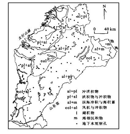
Removing the redundancy is one of the purposes of optimizing monitoring network, for redundant data made the data-noises and increased the operation cost. The main solution to remove redundancy is reduction of the number of monitoring wells under the precondition: there is no or few effect on the ability of information collected by network. A new approach based entropy for optimization was presented in this paper. This procedure is a three-phase method, in which the entropy was employed to measure the ability of individual station and the information transfer coefficient between well pairs was considered as a measurement of information relationships. The different statistical relationships were found between the information transfer coefficients and the distances among wells located at different geological deposits, which is the base to determine the redundant wells. This approach was demonstrated using the data from the regional-scale groundwater flow system in Hebei plain, China, 36 wells in 140 wells distributed whole area were identified as the redundant wells. And the abilities of information collected were almost the same as that before even though the 36 wells were removed.
Removing the redundancy is one of the purposes of optimizing monitoring network, for redundant data made the data-noises and increased the operation cost. The main solution to remove redundancy is reduction of the number of monitoring wells under the precondition: there is no or few effect on the ability of information collected by network. A new approach based entropy for optimization was presented in this paper. This procedure is a three-phase method, in which the entropy was employed to measure the ability of individual station and the information transfer coefficient between well pairs was considered as a measurement of information relationships. The different statistical relationships were found between the information transfer coefficients and the distances among wells located at different geological deposits, which is the base to determine the redundant wells. This approach was demonstrated using the data from the regional-scale groundwater flow system in Hebei plain, China, 36 wells in 140 wells distributed whole area were identified as the redundant wells. And the abilities of information collected were almost the same as that before even though the 36 wells were removed.

2001, 26(5): 524-528.
Abstract:
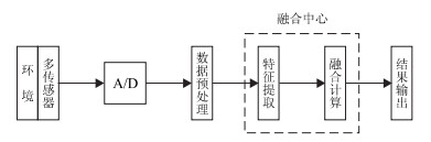
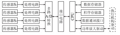
Multi-sensor data fusion is a new technique developed in recent years, which is now widely applied to military and civilian areas. This paper discusses basic principles and processes of multi-sensor fusion and puts forward a detecting scheme of dip and azimuth angle of a drilling hole according to the characteristics and demand of the automatic vertical drilling detecting system. Meanwhile, it presents two data fusion methods: one being based on the arithmetic average and expandable estimate for the vertical drilling system and the other, based on the arithmetic average and estimate in batch for the vertical drilling system. These methods can improve the anti-jamming ability of automatic vertical drilling detecting system in order to assure the parameter reliability and veracity of collecting datum.
Multi-sensor data fusion is a new technique developed in recent years, which is now widely applied to military and civilian areas. This paper discusses basic principles and processes of multi-sensor fusion and puts forward a detecting scheme of dip and azimuth angle of a drilling hole according to the characteristics and demand of the automatic vertical drilling detecting system. Meanwhile, it presents two data fusion methods: one being based on the arithmetic average and expandable estimate for the vertical drilling system and the other, based on the arithmetic average and estimate in batch for the vertical drilling system. These methods can improve the anti-jamming ability of automatic vertical drilling detecting system in order to assure the parameter reliability and veracity of collecting datum.

2001, 26(5): 529-532.
Abstract:
Convection-dispersion equation describing convection-dominated solute transport in unsaturated soil may be divided into two parts: convection and dispersion. They are resolved by the FCT (flux-corrected transport) algorithm and conventional alternate direction implicit finite difference method, respectively. The FCT algorithm includes two phases: one is low-order transport, in which excessive numerical diffusion may be introduced; the other is high-order flux-corrected, in which numerical dispersion and oscillation can be effectively eliminated through correcting (limiting) antidiffusion flux. Moreover, the moisture content is obtained by FUCG algorithm, which is able to conserve the mass balance. At last, the effectiveness of FCT algorithm is verified by the numerical examples.
Convection-dispersion equation describing convection-dominated solute transport in unsaturated soil may be divided into two parts: convection and dispersion. They are resolved by the FCT (flux-corrected transport) algorithm and conventional alternate direction implicit finite difference method, respectively. The FCT algorithm includes two phases: one is low-order transport, in which excessive numerical diffusion may be introduced; the other is high-order flux-corrected, in which numerical dispersion and oscillation can be effectively eliminated through correcting (limiting) antidiffusion flux. Moreover, the moisture content is obtained by FUCG algorithm, which is able to conserve the mass balance. At last, the effectiveness of FCT algorithm is verified by the numerical examples.

2001, 26(5): 533-537.
Abstract:
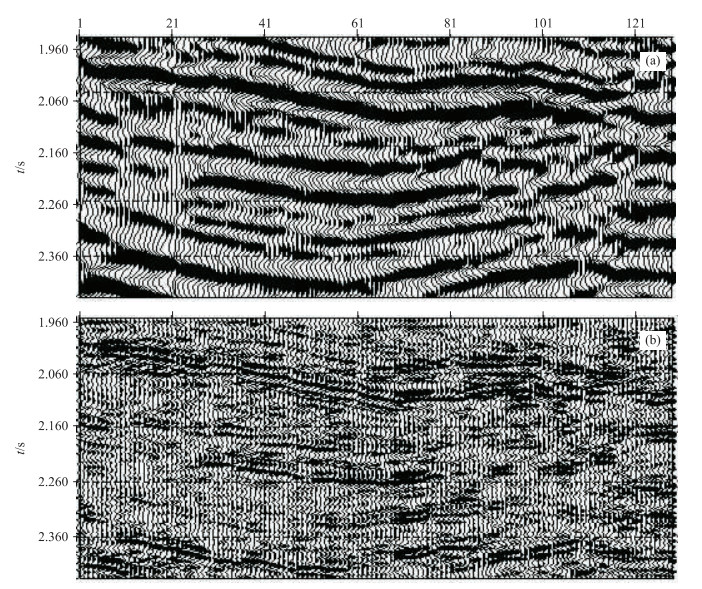
Multi-scale (multi-resolution) inversion is an inversion tactics that has been put forward in recent years. Its purpose is to increase inversion convergence rate and decrease the local minimum effect so as to search for the global minimum. In the light of geological theory, high vertical resolution logging data and good transverse continuity seismic data are used to make seismic trace inversion. At the same time, the idea of wavelet transform multi-scale analysis is applied in the inversion, which has achieved seismic trace multi-scale (multi-resolution) inversion. The procession of theoretical and practical data state that this kind of inversion method has the features of quick convergence rate, high inversion precision and strong ability of accommodation.
Multi-scale (multi-resolution) inversion is an inversion tactics that has been put forward in recent years. Its purpose is to increase inversion convergence rate and decrease the local minimum effect so as to search for the global minimum. In the light of geological theory, high vertical resolution logging data and good transverse continuity seismic data are used to make seismic trace inversion. At the same time, the idea of wavelet transform multi-scale analysis is applied in the inversion, which has achieved seismic trace multi-scale (multi-resolution) inversion. The procession of theoretical and practical data state that this kind of inversion method has the features of quick convergence rate, high inversion precision and strong ability of accommodation.
2001, 26(5): 538-540.
Abstract:
An approach to solving global optimization and inversion problems is developed. It builds 2-order trend surface analysis of abandoned search information in heuristic nonlinear inversion - simulated annealing. The fundamental of this approach is that SA changes process of random search according to prediction of trend surface analysis with some solutions of search in model space so that it ensures inversion to converge to the global optimum fast and exactly. The numerical test of a typical economics inversion problem has proved that this approach can improve the efficiency of simulated annealing remarkably.
An approach to solving global optimization and inversion problems is developed. It builds 2-order trend surface analysis of abandoned search information in heuristic nonlinear inversion - simulated annealing. The fundamental of this approach is that SA changes process of random search according to prediction of trend surface analysis with some solutions of search in model space so that it ensures inversion to converge to the global optimum fast and exactly. The numerical test of a typical economics inversion problem has proved that this approach can improve the efficiency of simulated annealing remarkably.
2001, 26(5): 541-544.
Abstract:
The research of multiple suppression and analysis of influence of multiple amplitude upon primary amplitude-via-offset (AVO) need an effective multiple-modeling method. Thus, a new method has been developed that can automatically calculate multiple ray codes in any complex stratified media, making multiple ray trace fast. Meanwhile, an approach to the computation of multiple amplitude by methods of seeking table and interpolation are discussed. The modeling result shows that the method is of high precision and fast-speed in multiple amplitude calculation. The maximum relative error of amplitude is 1.8% and the spent time by using the method has decreased by 0.4 times one by using accurate ray tracing in the designed model.
The research of multiple suppression and analysis of influence of multiple amplitude upon primary amplitude-via-offset (AVO) need an effective multiple-modeling method. Thus, a new method has been developed that can automatically calculate multiple ray codes in any complex stratified media, making multiple ray trace fast. Meanwhile, an approach to the computation of multiple amplitude by methods of seeking table and interpolation are discussed. The modeling result shows that the method is of high precision and fast-speed in multiple amplitude calculation. The maximum relative error of amplitude is 1.8% and the spent time by using the method has decreased by 0.4 times one by using accurate ray tracing in the designed model.


2001, 26(5): 545-550.
Abstract:
The separate and static management status of geology information hasn't been able to meet the market economy's development and variety, scientificity and imminence of widely social demands, also extremely restrict the total exertion of social economy benefits of geology information. According to the achieved results of regional multi-source geology spatial information integration projects, based on GIS theory and technique and the characteristics of multi-source geological information spatial data application, the discussion of technical methods about regional multi-source geology spatial information integration is given, and also narrates in details the programming and design of multi-source geological geographical information system, the capturing techniques of data, metadata, the projection, reference frame, the physical design and stipulation as well as the features of the quality of integration data.
The separate and static management status of geology information hasn't been able to meet the market economy's development and variety, scientificity and imminence of widely social demands, also extremely restrict the total exertion of social economy benefits of geology information. According to the achieved results of regional multi-source geology spatial information integration projects, based on GIS theory and technique and the characteristics of multi-source geological information spatial data application, the discussion of technical methods about regional multi-source geology spatial information integration is given, and also narrates in details the programming and design of multi-source geological geographical information system, the capturing techniques of data, metadata, the projection, reference frame, the physical design and stipulation as well as the features of the quality of integration data.
