


2001 Vol. 26, No. 6
Display Method:
2001, 26(6): 551-559.
 PDF 1048KB
Abstract:
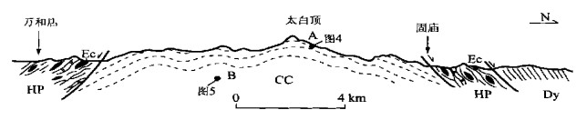
The Tongbai Mountains is an important component part of the Qinling-Dabieshan orogenic belt. The recent detailed researches in tectonics and petrology show that a great amount of eclogites or retrograded eclogites in different sizes, widely distributed in the Tongbai mountains, constitutes a high-pressure metamorphic belt, around 200 km long and 40 km wide. The high-pressure metamorphic unit is generally composed of the following four different major lithologies: (1) eclogites and retrograded eclogites; (2) HP-metamorphosed sedimentation and volcanic rocks; (3) gneissic or schistose rocks resulting from retrogressive HP eclogites; and (4) foliated garnet-bearing granites or garnet-free granites. The rock assemblages and metamorphic evolution of this high-pressure unit are similar to those in the Dabie-Sulu ultrahigh pressure (UHP) and high-pressure metamorphic belts. The regional structural pattern of the HP metamorphic belt in the Tongbai Mountains corresponds perfectly to a Cordilleran-type metamorphic core complex where three crustal-scale, gently-dipping, normal-sense detachment zones were developed. The composite detachment zone resulted possibly from both the lower detachment zone and the middle detachment zone is presently sandwiched between the core complex unit (CC) below, and the high-pressure metamorphic unit (HP) above. The structures controlling the present spatial distribution of HP metamorphic rocks were dominantly products of an extensional process following the Triassic HP metamorphism. Both structural considerations and concordant field relations suggest that the Tongbai HP metamorphic unit is an important part of the Dabie-Sulu UHP and HP metamorphic belts. Its western extension overlain by the Mesozoic to Cenozoic sedimentary rocks may have crossed the Nanxiang basin to the Eastern Qinling. The new findings and ideas should be employed for the reconstruction of the evolution of the whole Qinling-Dabie orogenic belt. The Tongbai high-pressure metamorphic belt serves as a structure linking the Eastern Qinling orogen with the Dabie-Sulu UHP and HP metamorphic belts.
The Tongbai Mountains is an important component part of the Qinling-Dabieshan orogenic belt. The recent detailed researches in tectonics and petrology show that a great amount of eclogites or retrograded eclogites in different sizes, widely distributed in the Tongbai mountains, constitutes a high-pressure metamorphic belt, around 200 km long and 40 km wide. The high-pressure metamorphic unit is generally composed of the following four different major lithologies: (1) eclogites and retrograded eclogites; (2) HP-metamorphosed sedimentation and volcanic rocks; (3) gneissic or schistose rocks resulting from retrogressive HP eclogites; and (4) foliated garnet-bearing granites or garnet-free granites. The rock assemblages and metamorphic evolution of this high-pressure unit are similar to those in the Dabie-Sulu ultrahigh pressure (UHP) and high-pressure metamorphic belts. The regional structural pattern of the HP metamorphic belt in the Tongbai Mountains corresponds perfectly to a Cordilleran-type metamorphic core complex where three crustal-scale, gently-dipping, normal-sense detachment zones were developed. The composite detachment zone resulted possibly from both the lower detachment zone and the middle detachment zone is presently sandwiched between the core complex unit (CC) below, and the high-pressure metamorphic unit (HP) above. The structures controlling the present spatial distribution of HP metamorphic rocks were dominantly products of an extensional process following the Triassic HP metamorphism. Both structural considerations and concordant field relations suggest that the Tongbai HP metamorphic unit is an important part of the Dabie-Sulu UHP and HP metamorphic belts. Its western extension overlain by the Mesozoic to Cenozoic sedimentary rocks may have crossed the Nanxiang basin to the Eastern Qinling. The new findings and ideas should be employed for the reconstruction of the evolution of the whole Qinling-Dabie orogenic belt. The Tongbai high-pressure metamorphic belt serves as a structure linking the Eastern Qinling orogen with the Dabie-Sulu UHP and HP metamorphic belts.


2001, 26(6): 560-567.
Abstract:
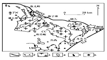
The present constitution and architecture of the Tongbai-Dabie orogenic belt is the combined result of the Triassic subduction collision, the extension tectonics postdating the HP-and UHP metamorphism, and thermo-tectonic evolutions in the Mesozoic-Cenozoic time. In addition to Yanshanian and post-Yanshanian magmatic intrusions, volcanics, and basin deposits, the lithotectonic constituents of the Dabie orogenic belt mainly consist of a core complex (CC) unit, a UHP unit, a HP unit, an epidote blueschist (EBS) unit and a sedimentary cover (SC) unit. Minor mafic-ultramafic plutons or massifs were intruded into or preserved within them. The rock slices of UHP, HP, and EBS units are progressively sandwiched between the underlying core complex and the overlying sedimentary cover. The distribution of lithotectonic units is controlled by an extensional tectonic framework postdated the collisional event. The tectonic pattern of the Tongbai-Dabie orogenic belt as a whole is similar to that of the metamorphic core complex described from the western North America, which is characterized by a general doming morphology with the development of multi-layered detachment zones.
The present constitution and architecture of the Tongbai-Dabie orogenic belt is the combined result of the Triassic subduction collision, the extension tectonics postdating the HP-and UHP metamorphism, and thermo-tectonic evolutions in the Mesozoic-Cenozoic time. In addition to Yanshanian and post-Yanshanian magmatic intrusions, volcanics, and basin deposits, the lithotectonic constituents of the Dabie orogenic belt mainly consist of a core complex (CC) unit, a UHP unit, a HP unit, an epidote blueschist (EBS) unit and a sedimentary cover (SC) unit. Minor mafic-ultramafic plutons or massifs were intruded into or preserved within them. The rock slices of UHP, HP, and EBS units are progressively sandwiched between the underlying core complex and the overlying sedimentary cover. The distribution of lithotectonic units is controlled by an extensional tectonic framework postdated the collisional event. The tectonic pattern of the Tongbai-Dabie orogenic belt as a whole is similar to that of the metamorphic core complex described from the western North America, which is characterized by a general doming morphology with the development of multi-layered detachment zones.


2001, 26(6): 568-573.
Abstract:
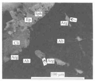
The aragonite, an index mineral of glaucophane schist facies, has not been confirmed in the Dabie Mountains high-pressure and ultrahigh-pressure metamorphic belts. The Mulanshan glaucophane schist in Huangpi County, Hubei Province, is located in the southwestern Dabie mountains, central China. The micro-sized inter-granular aragonite is confirmed with optical microscope (OM) and electron probe microanalysis (EPMA) in the glaucophane schist. The submicrometer-sized ellipse aragonite inclusion is observed by using bright-field image (BFI), X-ray energy-damage spectrograph (EDS), and selected area electron diffraction (SAED) with transmission electron microscope in the quartz lens of glaucophane-albite-epidote-chlorite schist from the Mulanshan. The presence of aragonite indicates not only the average geothermal gradient of the Mulanshan glaucophane schist less than 10 ℃/km, which is very close to that of eclogite in the Dabie Mountain metamorphic belts, but also the relatively higher concentration of CO2 during the metamorphic process. In addition, the glaucophane schist free of such index minerals as lawsonite, prehnite, and pumpellyite, has been attributed to the effect of CO2 on the stability of calcium aluminum silicate minerals during the low-grade metamorphism. EDS and SAED analysis results show that the host of aragonite inclusion is amorphous SiO 2. The occurrence of amorphous SiO 2 indicates a quick cooling process during the exhumation of the Mulanshan glaucophane schist. These results suggest that the rapid exhumation mechanism of the glaucophane schist, the same as that of eclogite in the Dabie Mountain metamorphic belts, occurred in the geodynamic context of subduction-obduction.
The aragonite, an index mineral of glaucophane schist facies, has not been confirmed in the Dabie Mountains high-pressure and ultrahigh-pressure metamorphic belts. The Mulanshan glaucophane schist in Huangpi County, Hubei Province, is located in the southwestern Dabie mountains, central China. The micro-sized inter-granular aragonite is confirmed with optical microscope (OM) and electron probe microanalysis (EPMA) in the glaucophane schist. The submicrometer-sized ellipse aragonite inclusion is observed by using bright-field image (BFI), X-ray energy-damage spectrograph (EDS), and selected area electron diffraction (SAED) with transmission electron microscope in the quartz lens of glaucophane-albite-epidote-chlorite schist from the Mulanshan. The presence of aragonite indicates not only the average geothermal gradient of the Mulanshan glaucophane schist less than 10 ℃/km, which is very close to that of eclogite in the Dabie Mountain metamorphic belts, but also the relatively higher concentration of CO2 during the metamorphic process. In addition, the glaucophane schist free of such index minerals as lawsonite, prehnite, and pumpellyite, has been attributed to the effect of CO2 on the stability of calcium aluminum silicate minerals during the low-grade metamorphism. EDS and SAED analysis results show that the host of aragonite inclusion is amorphous SiO 2. The occurrence of amorphous SiO 2 indicates a quick cooling process during the exhumation of the Mulanshan glaucophane schist. These results suggest that the rapid exhumation mechanism of the glaucophane schist, the same as that of eclogite in the Dabie Mountain metamorphic belts, occurred in the geodynamic context of subduction-obduction.


2001, 26(6): 574-580.
Abstract:
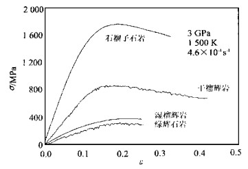
The authors present here experimental study of the rheological properties of UHP eclogite from Dabie at a pressure of 3 GPa by utilizing the 5 GPa Griggs-type piston cylinder apparatus. The rheological constitutive equation of eclogite is determined with a stress exponent of 3.4, an activation energy of 480 kJ/mol and a pre-exponential factor of 103.3. The study shows that: (1) As a typical two-phase rock, the flow strength of eclogite depends on the proportions between the strong phase (garnet) and the weak phase (omphacite); (2) The plastic deformation of eclogite is dominated by dislocation creep; (3) The research result that eclogite has the same strength as does the upper mantle harzburgite suggests that the delamination of the subducting crust component from the underlying upper mantle is unlikely. Therefore, the stretching after the collision orogeny coupled with the upwelling of the upper mantle might play a more important role in the exhumation of UHP rocks.
The authors present here experimental study of the rheological properties of UHP eclogite from Dabie at a pressure of 3 GPa by utilizing the 5 GPa Griggs-type piston cylinder apparatus. The rheological constitutive equation of eclogite is determined with a stress exponent of 3.4, an activation energy of 480 kJ/mol and a pre-exponential factor of 103.3. The study shows that: (1) As a typical two-phase rock, the flow strength of eclogite depends on the proportions between the strong phase (garnet) and the weak phase (omphacite); (2) The plastic deformation of eclogite is dominated by dislocation creep; (3) The research result that eclogite has the same strength as does the upper mantle harzburgite suggests that the delamination of the subducting crust component from the underlying upper mantle is unlikely. Therefore, the stretching after the collision orogeny coupled with the upwelling of the upper mantle might play a more important role in the exhumation of UHP rocks.


2001, 26(6): 581-596.
Abstract:
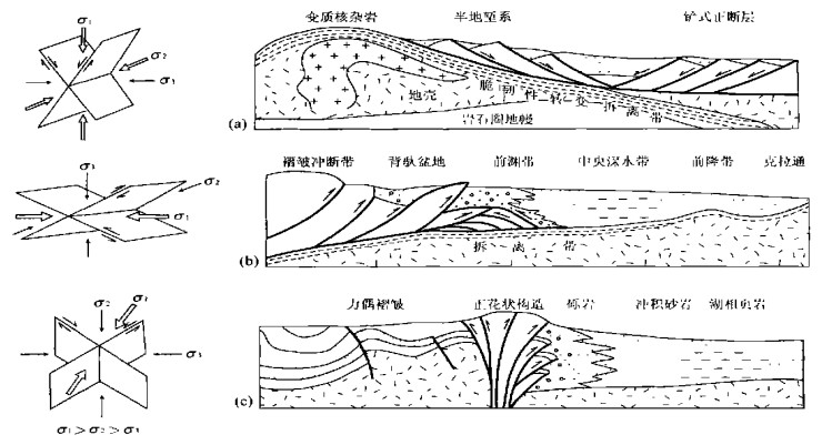
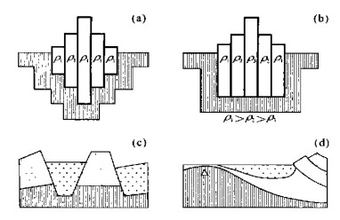
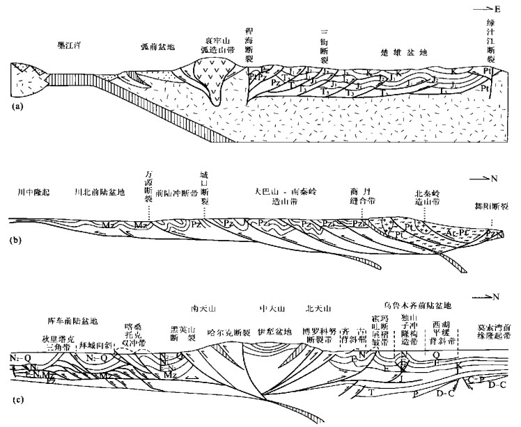
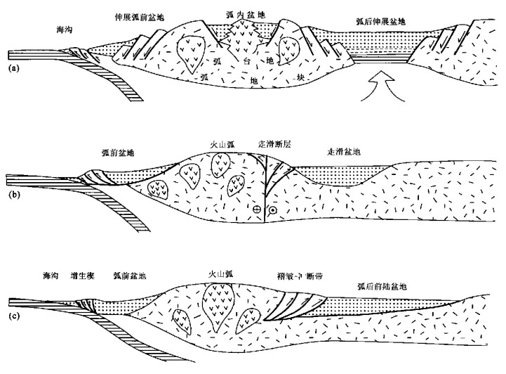
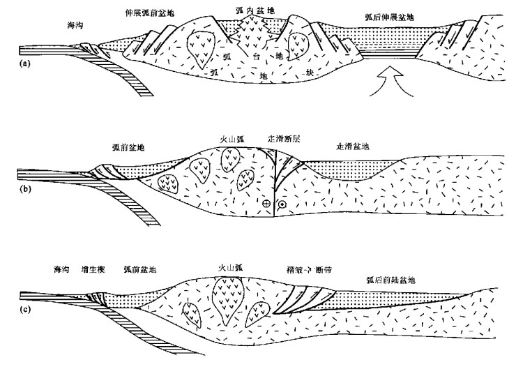
The concept of the coupling of basin and mountain system is to well organize and combine the former isolated basin analysis and mountain research together through the geodynamic scenario and the plate tectonic setting analysis. Geodynamic scenario, including extensional tectonic system, contractional tectonic system, transcurrent tectonic system, and cratonic system, can lead geologists to get the right ideas of qualitative and quantitative analysis in their research. At the same time, plate tectonic setting, including rifting stage, subduction stages, collision stage, and post-orogenic stage, can provide them with the knowledge of the geological events in space and time. According to the extensional regime, there are continental rift basins and extending orogen in divergent stage, back-arc basins and magmatic orogen in converging stage, and successor rift basins and late-extensional orogen in post-orogenic stage. While in the contractional regime, there are retro-arc foreland basins and subduction orogenic belts in subduction stage, peripheral foreland basins and collisional orogenic belts in collision stage, and reactivated foreland basins and recycling orogenic belt in reactivated stage. In transcurrent regime, there are transtensional basins and range in transtensional stage, and transpressional basin and mountain zones in transpressional stage. In cratonic regime, there are intracratonic basins in divergent stage, and craton-margin basins in converging stage.
The concept of the coupling of basin and mountain system is to well organize and combine the former isolated basin analysis and mountain research together through the geodynamic scenario and the plate tectonic setting analysis. Geodynamic scenario, including extensional tectonic system, contractional tectonic system, transcurrent tectonic system, and cratonic system, can lead geologists to get the right ideas of qualitative and quantitative analysis in their research. At the same time, plate tectonic setting, including rifting stage, subduction stages, collision stage, and post-orogenic stage, can provide them with the knowledge of the geological events in space and time. According to the extensional regime, there are continental rift basins and extending orogen in divergent stage, back-arc basins and magmatic orogen in converging stage, and successor rift basins and late-extensional orogen in post-orogenic stage. While in the contractional regime, there are retro-arc foreland basins and subduction orogenic belts in subduction stage, peripheral foreland basins and collisional orogenic belts in collision stage, and reactivated foreland basins and recycling orogenic belt in reactivated stage. In transcurrent regime, there are transtensional basins and range in transtensional stage, and transpressional basin and mountain zones in transpressional stage. In cratonic regime, there are intracratonic basins in divergent stage, and craton-margin basins in converging stage.


2001, 26(6): 597-602.
Abstract:
The crustal heat generation rate of major tectonic units in China are calculated on the basis of heat flow, crustal thickness as well as the inverse relation between the heat flow ratio of continental crust/mantle and the helium isotopic composition of underground fluid. Meanwhile, the linear relation between heat generation (A) and SiO2 content (w(SiO2)) of the bulk crust is obtained from the data of Rudnick and Fountain (1995). Then, the w(SiO2) of China's crust are derived from the w(SiO2) -A relation. The derived w(SiO2) and A are in agreement with the values obtained from the seismic velocity-based composition models. There exhibits an obvious lateral variation of heat production and w(SiO2) in China's crust. The eastern China crustal composition, intermediate, contains relatively concentrated strong incompatible elements, but the crustal composition of the northwestern China basins is prone to be intermediate to mafic. The crustal compositions in North China, Yangtze craton and Tarim platform are different from each other to a relatively great extent. Obvious lateral variation of composition is also present within cratons. The orogenic crust often contains slightly more felsic components than does craton.
The crustal heat generation rate of major tectonic units in China are calculated on the basis of heat flow, crustal thickness as well as the inverse relation between the heat flow ratio of continental crust/mantle and the helium isotopic composition of underground fluid. Meanwhile, the linear relation between heat generation (A) and SiO2 content (w(SiO2)) of the bulk crust is obtained from the data of Rudnick and Fountain (1995). Then, the w(SiO2) of China's crust are derived from the w(SiO2) -A relation. The derived w(SiO2) and A are in agreement with the values obtained from the seismic velocity-based composition models. There exhibits an obvious lateral variation of heat production and w(SiO2) in China's crust. The eastern China crustal composition, intermediate, contains relatively concentrated strong incompatible elements, but the crustal composition of the northwestern China basins is prone to be intermediate to mafic. The crustal compositions in North China, Yangtze craton and Tarim platform are different from each other to a relatively great extent. Obvious lateral variation of composition is also present within cratons. The orogenic crust often contains slightly more felsic components than does craton.

2001, 26(6): 603-608.
Abstract:
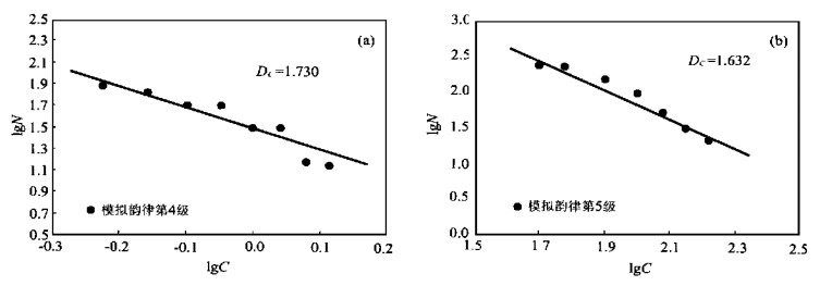
In this paper, the fractal theory is applied to the fractal calculation of thickness of rhythmic layers in Panzhihua layered intrusion in Sichuan Province, China. In addition, this paper discusses the origin of the rhythmic stratification by means of computer simulation. The fractal research on the thickness of Panzhihua layered intrusion shows an excellent fractal structure with its dimension ranging between 1.4 and 1.8. The fractal dimension of thickness varies with different grades of rhythmic layers. The higher the grade of the rhythmic evolution is, the greater the fractal dimension of thickness is. The fractal dimension of rhythmic color thus simulated is close to that of the thickness of the measured rhythmic layer in addition to similar changing patterns, which indicate that a certain internal association is present between the thickness and the chrominance of the rhythm in the process of the magma evolvement, and that the gravity is an important factor of the formation mechanism of the rhythm. The coupling in space and time between earth gravity and other earth physical and chemical effects results in this kind of rhythmic pattern with spatio-temporal fractal structure.
In this paper, the fractal theory is applied to the fractal calculation of thickness of rhythmic layers in Panzhihua layered intrusion in Sichuan Province, China. In addition, this paper discusses the origin of the rhythmic stratification by means of computer simulation. The fractal research on the thickness of Panzhihua layered intrusion shows an excellent fractal structure with its dimension ranging between 1.4 and 1.8. The fractal dimension of thickness varies with different grades of rhythmic layers. The higher the grade of the rhythmic evolution is, the greater the fractal dimension of thickness is. The fractal dimension of rhythmic color thus simulated is close to that of the thickness of the measured rhythmic layer in addition to similar changing patterns, which indicate that a certain internal association is present between the thickness and the chrominance of the rhythm in the process of the magma evolvement, and that the gravity is an important factor of the formation mechanism of the rhythm. The coupling in space and time between earth gravity and other earth physical and chemical effects results in this kind of rhythmic pattern with spatio-temporal fractal structure.


2001, 26(6): 609-614.
Abstract:
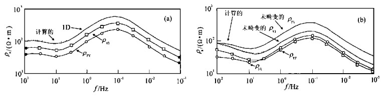
The inversion for TEMdata using the observed magnetic fields instead of using the apparent resistivities avoids the errors caused by the definition of the TEMapparent resistivity. In addition, the inversed results by fitting the magnetic fields of the transmitter source's image to those of the observed magnetic fields are relatively less affected by the conductivity inhomogeneity. The MTapparent curves calculated from the geo-electric model constructed with the TEMinversion results, serve as reference curves for the more reliable correction of MTstatic shift, and also actualize the transformation from time domain to frequency domain between these two kinds of electromagnetic data. Therefore, TEMinversion can be applied to the correction of the MT static shift. Many field studies show that this method is very effective for the judgment and correction of the MTstatic shift.
The inversion for TEMdata using the observed magnetic fields instead of using the apparent resistivities avoids the errors caused by the definition of the TEMapparent resistivity. In addition, the inversed results by fitting the magnetic fields of the transmitter source's image to those of the observed magnetic fields are relatively less affected by the conductivity inhomogeneity. The MTapparent curves calculated from the geo-electric model constructed with the TEMinversion results, serve as reference curves for the more reliable correction of MTstatic shift, and also actualize the transformation from time domain to frequency domain between these two kinds of electromagnetic data. Therefore, TEMinversion can be applied to the correction of the MT static shift. Many field studies show that this method is very effective for the judgment and correction of the MTstatic shift.


2001, 26(6): 615-620.
Abstract:
The principle and method for sequence stratigraphy are applied to the establishment of the framework of Mesozoic sequence stratigraphy in Yanqi basin. This framework, classifying the Mesozoic sequence stratigraphy into four sequences, is used to analyze the stratigraphic features of different sequences, sequence evolution, and spreading of the sedimentary systems in different systems tracts. The research shows that two sedimentary source systems, southern and northern ones, are present in Yanqi Mesozoic basin. This basin is dominated by the fluvial and limnetic shallow water deposition. The lacustrine water body is shallow and its distribution is limited. The progressive systems tract in Sequence Ⅲ is marked by the peak lacustrine growth period. This paper also discusses the potential horizons and zones favorable for the growth of subtle traps.
The principle and method for sequence stratigraphy are applied to the establishment of the framework of Mesozoic sequence stratigraphy in Yanqi basin. This framework, classifying the Mesozoic sequence stratigraphy into four sequences, is used to analyze the stratigraphic features of different sequences, sequence evolution, and spreading of the sedimentary systems in different systems tracts. The research shows that two sedimentary source systems, southern and northern ones, are present in Yanqi Mesozoic basin. This basin is dominated by the fluvial and limnetic shallow water deposition. The lacustrine water body is shallow and its distribution is limited. The progressive systems tract in Sequence Ⅲ is marked by the peak lacustrine growth period. This paper also discusses the potential horizons and zones favorable for the growth of subtle traps.


2001, 26(6): 621-626.
Abstract:
The detection of pyrrolic nitrogen compounds in oils of Gasikule oilfield, Qaidam basin, western China reveals apparent migration effects of pyrrolic nitrogen compounds in the oils, indicating that the main charging points of Gasikule oilfield of lower anticline pool (E31) are on the two sides of the anticline along the direction of the short axis, especially along the right side of the anticline. The main migration directions of oil redistribution range from the middle of the anticline to the two sides of the long axis. Most oils are supposed to come from Manya sag in the northeast of the pool, and only minority of oils, accumulated in the southwest of the anticlinal pool, are supposed to come from Gasi sag itself. The geological background of this area determines the oil migration and accumulation patterns, further indicating that disconformity and fracture are the two major paths for the oil migration.
The detection of pyrrolic nitrogen compounds in oils of Gasikule oilfield, Qaidam basin, western China reveals apparent migration effects of pyrrolic nitrogen compounds in the oils, indicating that the main charging points of Gasikule oilfield of lower anticline pool (E31) are on the two sides of the anticline along the direction of the short axis, especially along the right side of the anticline. The main migration directions of oil redistribution range from the middle of the anticline to the two sides of the long axis. Most oils are supposed to come from Manya sag in the northeast of the pool, and only minority of oils, accumulated in the southwest of the anticlinal pool, are supposed to come from Gasi sag itself. The geological background of this area determines the oil migration and accumulation patterns, further indicating that disconformity and fracture are the two major paths for the oil migration.


2001, 26(6): 627-630.
Abstract:
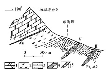
Tectonics is not only the main channel of ore-forming fluid transferring, but also the place where mineralizing elements are precipitated. Therefore, the searching for the structure belt is very important for mineral exploration. But not all structures contain minerals, so it is necessary to identify whether the structure contains mineral or not, especially those structures with no mineralization marker and with blinding mineralization. To attain the above goal, we have made some related identification research with XRF, geogas prospecting, and Radon detection methods. The test on Axi gold deposit and Tianwan gold deposit in Sichuan Province shows the validity of above method in distinguishing whether the structure contains minerals or not.
Tectonics is not only the main channel of ore-forming fluid transferring, but also the place where mineralizing elements are precipitated. Therefore, the searching for the structure belt is very important for mineral exploration. But not all structures contain minerals, so it is necessary to identify whether the structure contains mineral or not, especially those structures with no mineralization marker and with blinding mineralization. To attain the above goal, we have made some related identification research with XRF, geogas prospecting, and Radon detection methods. The test on Axi gold deposit and Tianwan gold deposit in Sichuan Province shows the validity of above method in distinguishing whether the structure contains minerals or not.


2001, 26(6): 631-637.
Abstract:
The authors analyzed the space and time relationship between the décollement-extrusion tectonics and the gold mineralization in the adjoining area of Sichuan, Gansu and Shaanxi provinces and its effect on the activity and migration of geochemical elements in the décollement shear zone. The large and super-large gold deposits are all controlled mainly by the secondary- and primary-order décollement zones in the area. This reseach result provides us with the structural basis for the forecasting of gold-mine prospective location in this area.
The authors analyzed the space and time relationship between the décollement-extrusion tectonics and the gold mineralization in the adjoining area of Sichuan, Gansu and Shaanxi provinces and its effect on the activity and migration of geochemical elements in the décollement shear zone. The large and super-large gold deposits are all controlled mainly by the secondary- and primary-order décollement zones in the area. This reseach result provides us with the structural basis for the forecasting of gold-mine prospective location in this area.


2001, 26(6): 638-642.
Abstract:
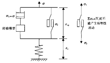
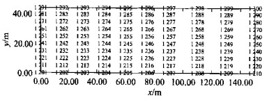
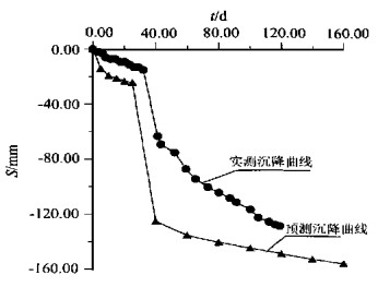
The elastic-visco-plastic constitution has been employed for the programming of 3D-FEM for the soft saturated clay in Shanghai. The program has also been applied to the prediction of the post-construction subsidence of fill bridge-slope on the soft clay basement. The comparison between the predicted value and measured value proved that the creep effect is a dominant factor for the production of post-construction subsidence of the fill bridge-slope.
The elastic-visco-plastic constitution has been employed for the programming of 3D-FEM for the soft saturated clay in Shanghai. The program has also been applied to the prediction of the post-construction subsidence of fill bridge-slope on the soft clay basement. The comparison between the predicted value and measured value proved that the creep effect is a dominant factor for the production of post-construction subsidence of the fill bridge-slope.


2001, 26(6): 643-647.
Abstract:
Flooding control is an urgent problem in the middle reaches of the Yangtze River. In this paper, the authors present deep-layer causes of the flooding and water logging in the middle reaches of Yangtze River and some possibilities of application of "3S" technology to the construction of decision-making support system for the monitoring and evaluation of these flooding and water logging hazards. The authors then present the basic framework of system design and the structural flow chart of the test area construction. Therefore, the construction of this system and the application of high and new technology can both be employed to provide scientific decision-making support for the prevention of the flooding and water logging in the middle reaches of the Yangtze River.
Flooding control is an urgent problem in the middle reaches of the Yangtze River. In this paper, the authors present deep-layer causes of the flooding and water logging in the middle reaches of Yangtze River and some possibilities of application of "3S" technology to the construction of decision-making support system for the monitoring and evaluation of these flooding and water logging hazards. The authors then present the basic framework of system design and the structural flow chart of the test area construction. Therefore, the construction of this system and the application of high and new technology can both be employed to provide scientific decision-making support for the prevention of the flooding and water logging in the middle reaches of the Yangtze River.

2001, 26(6): 648-652.
Abstract:
The experimental research into the application of GIS satellite positioning technique to the monitoring of technology to the monitoring of landslides in Three Gorges dam, is an important project financed by the Ministry of Land and Resources to modernize the geological hazard monitoring, forecasting and prevention. This experimental research is to analyze, study and prove the feasibility of the application of GPS satellite positioning technique to the monitoring of landslides, to formulate technical regulations, and to build a demonstration region of the application of GPS to the monitoring of geological hazards in the section from Lianziya to Badong. The experimental research into the GPS-based monitoring of the landslides in Three Gorges dam deals with the selections of the optimum GPS monitoring hour, the optimum GPS monitoring duration, the optimum cutoff elevation angle for the GPS monitoring, and with the adoption of appropriate software and ephemeris. The research results show that GPS satellite positioning technique which can satisfy the precision required for the monitoring of the landslides is feasible.
The experimental research into the application of GIS satellite positioning technique to the monitoring of technology to the monitoring of landslides in Three Gorges dam, is an important project financed by the Ministry of Land and Resources to modernize the geological hazard monitoring, forecasting and prevention. This experimental research is to analyze, study and prove the feasibility of the application of GPS satellite positioning technique to the monitoring of landslides, to formulate technical regulations, and to build a demonstration region of the application of GPS to the monitoring of geological hazards in the section from Lianziya to Badong. The experimental research into the GPS-based monitoring of the landslides in Three Gorges dam deals with the selections of the optimum GPS monitoring hour, the optimum GPS monitoring duration, the optimum cutoff elevation angle for the GPS monitoring, and with the adoption of appropriate software and ephemeris. The research results show that GPS satellite positioning technique which can satisfy the precision required for the monitoring of the landslides is feasible.
2001, 26(6): 653-656.
Abstract:
This paper deals with highway routing decision-making on the basis of the Geographic Information System (GIS) and the Spatial Decision-making Supporting System (SDSS), with CITYSTAR, a tool of geographic information system, as a platform, and VB as a developing tool. Following the principle of highway routing, the authors discuss the application of GIS and SDSS to the highway routing. Finally, the authors present their preliminary design of the highway routing decision-making supporting system, with such Circum-Jiaozhou Bay regions as Qingdao, Huangdao, Linshanwei, and Nanling as the research targets.
This paper deals with highway routing decision-making on the basis of the Geographic Information System (GIS) and the Spatial Decision-making Supporting System (SDSS), with CITYSTAR, a tool of geographic information system, as a platform, and VB as a developing tool. Following the principle of highway routing, the authors discuss the application of GIS and SDSS to the highway routing. Finally, the authors present their preliminary design of the highway routing decision-making supporting system, with such Circum-Jiaozhou Bay regions as Qingdao, Huangdao, Linshanwei, and Nanling as the research targets.


2001, 26(6): 657-660.
Abstract:
When the K-feldspar containing ferric and ferrous impurity is used to synthesize zeolite molecular sieves and to extract potassium carbonate, the ferric and ferrous impurity may decrease the whiteness of zeolite. Iron removal experiments by leaching with sulfuric acids were performed for three K-feldspar powder samples, selected from Pinggu of Beijing, Jixian of Tianjin, and Baiyun Ebo district of Inner Mongolia, respectively. For the K-feldspar powder materials from Pinggu, Jixian, and Baiyun Ebo, the most leaching proportions of iron was 88.6%, 93.2%, and 64.6%, respectively. For the former two K-feldspar powders, iron leaching was performed in a similar way, resulting in a higher efficiency of their iron removals than that for Baiyun Ebo K-feldspar powder. The influential factors for iron removal efficiency, such as sulfuric acid concentration, temperature, and reaction time, were studied with orthogonal experimental method. These factors worked distinctly for K-feldspar powders from different areas. The experimental results also shows that the iron dissolved fast at the beginning of the leaching reaction, and then the corresponding reaction rate slowed down. For these two reaction periods, the reaction rates were mainly governed firstly by chemical reaction, and then by diffusion.
When the K-feldspar containing ferric and ferrous impurity is used to synthesize zeolite molecular sieves and to extract potassium carbonate, the ferric and ferrous impurity may decrease the whiteness of zeolite. Iron removal experiments by leaching with sulfuric acids were performed for three K-feldspar powder samples, selected from Pinggu of Beijing, Jixian of Tianjin, and Baiyun Ebo district of Inner Mongolia, respectively. For the K-feldspar powder materials from Pinggu, Jixian, and Baiyun Ebo, the most leaching proportions of iron was 88.6%, 93.2%, and 64.6%, respectively. For the former two K-feldspar powders, iron leaching was performed in a similar way, resulting in a higher efficiency of their iron removals than that for Baiyun Ebo K-feldspar powder. The influential factors for iron removal efficiency, such as sulfuric acid concentration, temperature, and reaction time, were studied with orthogonal experimental method. These factors worked distinctly for K-feldspar powders from different areas. The experimental results also shows that the iron dissolved fast at the beginning of the leaching reaction, and then the corresponding reaction rate slowed down. For these two reaction periods, the reaction rates were mainly governed firstly by chemical reaction, and then by diffusion.

2001, 26(6): 661-664.
Abstract:
The effects of exploitation activities of mineral resources are mainly industrial contribution, market contribution, city contribution and communication contribution. The exploitation activities are an important engine for the rapid regional economic progress. In general, the resource advantage in western areas is mineral resources but agriculture resources. Because of the historical problem, intelligence supporting system and the level of science and technology are still very low there, and also a market development is needed in the exploitation of tourism resources. At the same time, industrialization is a necessary phase in realizing western economic development. The important components of western development strategy are the mining industry, which is regarded as the leading industry, the exploitation of mining resources on a large scale, and recognition of the after-mining industry.
The effects of exploitation activities of mineral resources are mainly industrial contribution, market contribution, city contribution and communication contribution. The exploitation activities are an important engine for the rapid regional economic progress. In general, the resource advantage in western areas is mineral resources but agriculture resources. Because of the historical problem, intelligence supporting system and the level of science and technology are still very low there, and also a market development is needed in the exploitation of tourism resources. At the same time, industrialization is a necessary phase in realizing western economic development. The important components of western development strategy are the mining industry, which is regarded as the leading industry, the exploitation of mining resources on a large scale, and recognition of the after-mining industry.
