2002 Vol. 27, No. 4
Display Method:
2002, 27(4): 357-365.
 PDF 337KB
Abstract:
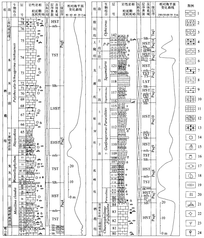
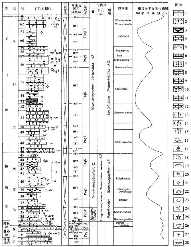
According to the latest International Chronostratigraphic Scheme (ICS, 2000), the Permian in the middle-lower Yangtze region of South China traditionally can be divided into three series and nine stages or relevant to six stages. From Assellian to Changxingian of Permian, 44 Ma in age range, the strata are composed of 14 third-order sequences, 3.14 Ma in average age range of each third-sequence. There is one third-order sequence in Zisongian, equivalent to middle and upper Chuanshan Formation or equal to Assellian and two thirds of Sakmarian. There are two third-order sequences, corresponding to Liangshan Formation or Zhenjiang Formation. And upper Chuanshan Formation, which are assigned to Longlingian, coinciding with Artinskian and one third of Sakmarian. In addition, three of them, equal to Qixia Formation, are attributed to Qixian, corresponding to Kubergandian and one third of Roadian. Five of them, comprising Kuhfeng Formation, Maokou Formation, Yanqiao Formation, Yinping Formation and Wuxue Formation, are assigned to Maokouan, equivalent to two thirds of Roadian, Wordian and Capitanian. Two of them, equal to Lungtan Formation or Wujiaping Formation, are included in Wujiapingian. Other two of them, corresponding to Changxing Formation or Talung Formation, are assigned to Changxingian. In brief, these above third-order sequences can be incorporated into 4 sequence sets.
According to the latest International Chronostratigraphic Scheme (ICS, 2000), the Permian in the middle-lower Yangtze region of South China traditionally can be divided into three series and nine stages or relevant to six stages. From Assellian to Changxingian of Permian, 44 Ma in age range, the strata are composed of 14 third-order sequences, 3.14 Ma in average age range of each third-sequence. There is one third-order sequence in Zisongian, equivalent to middle and upper Chuanshan Formation or equal to Assellian and two thirds of Sakmarian. There are two third-order sequences, corresponding to Liangshan Formation or Zhenjiang Formation. And upper Chuanshan Formation, which are assigned to Longlingian, coinciding with Artinskian and one third of Sakmarian. In addition, three of them, equal to Qixia Formation, are attributed to Qixian, corresponding to Kubergandian and one third of Roadian. Five of them, comprising Kuhfeng Formation, Maokou Formation, Yanqiao Formation, Yinping Formation and Wuxue Formation, are assigned to Maokouan, equivalent to two thirds of Roadian, Wordian and Capitanian. Two of them, equal to Lungtan Formation or Wujiaping Formation, are included in Wujiapingian. Other two of them, corresponding to Changxing Formation or Talung Formation, are assigned to Changxingian. In brief, these above third-order sequences can be incorporated into 4 sequence sets.


2002, 27(4): 367-372.
Abstract:
There are a lot of dinosaur footprints in the Early Cretaceous from Yanguoxia, Yongjing County, Gansu Province. Ten track sites about 293 footprints within 2 km2 area in Yanguoxia are discovered at present, three of which are being unearthed. Among all the sites, the footprints in site 1 are best preserved, where 212 footprints are found and arranged in 18 trackways or footprint groups within about 600 m2, consisting of 138 sauropod footprints, forming 4 well-preserved trackways and 3 footprint groups, 60 theropod footprints from 9 trackways, 3 ornithopod footprints from 1 trackways and 8 pterosaur footprints from 1 trackways. The largest sauropod footprint is 69 cm×112 cm in manus and 150 cm×142 cm in pes. It is suggested that it is one of the largest sauropod footprints in scale in the world. In view of their morphology, they can be divided into three types. The first is crescentic outline of manus and elliptical outline of pes, in which the footprints in manus and in pes are not coincident and rotate outward. The second is semicircular outline of manus and elliptical outline of pes, in which the footprints in manus and in pes are partly coincident and rotate outward. The third is semicircular outline of manus and broadly U-shaped outline of pes, in which the footprints in manus and in pes separate obviously and rotate outward. A sauropod footprint with a positive rotation is related to huge weight of the sauropod dinosaur. On the basis of calculation, the hip height of dinosaur is from 3.04 m to 5.3 m, and speed is about 2.3-3.4 km/h. Analysis of Cretaceous environment and paleogeography indicates that Gansu Lanzhou-Qinghai Minghe would be a freshwater lake basin of midland. The footprints of Yanguoxia were found on the western bank of the "Wusushan isolated paleo-island" nearest of the center of the lake. It was not humid in Cretaceous, but near the bank there was abundant grass and water, which could have been a paradise for dinosaur and the other terrigenous animals.
There are a lot of dinosaur footprints in the Early Cretaceous from Yanguoxia, Yongjing County, Gansu Province. Ten track sites about 293 footprints within 2 km2 area in Yanguoxia are discovered at present, three of which are being unearthed. Among all the sites, the footprints in site 1 are best preserved, where 212 footprints are found and arranged in 18 trackways or footprint groups within about 600 m2, consisting of 138 sauropod footprints, forming 4 well-preserved trackways and 3 footprint groups, 60 theropod footprints from 9 trackways, 3 ornithopod footprints from 1 trackways and 8 pterosaur footprints from 1 trackways. The largest sauropod footprint is 69 cm×112 cm in manus and 150 cm×142 cm in pes. It is suggested that it is one of the largest sauropod footprints in scale in the world. In view of their morphology, they can be divided into three types. The first is crescentic outline of manus and elliptical outline of pes, in which the footprints in manus and in pes are not coincident and rotate outward. The second is semicircular outline of manus and elliptical outline of pes, in which the footprints in manus and in pes are partly coincident and rotate outward. The third is semicircular outline of manus and broadly U-shaped outline of pes, in which the footprints in manus and in pes separate obviously and rotate outward. A sauropod footprint with a positive rotation is related to huge weight of the sauropod dinosaur. On the basis of calculation, the hip height of dinosaur is from 3.04 m to 5.3 m, and speed is about 2.3-3.4 km/h. Analysis of Cretaceous environment and paleogeography indicates that Gansu Lanzhou-Qinghai Minghe would be a freshwater lake basin of midland. The footprints of Yanguoxia were found on the western bank of the "Wusushan isolated paleo-island" nearest of the center of the lake. It was not humid in Cretaceous, but near the bank there was abundant grass and water, which could have been a paradise for dinosaur and the other terrigenous animals.

2002, 27(4): 373-376+468.
Abstract:
The Tertiary Guide Group largely bassets in the north of the source of the Yellow River. The paper describes the spores and pollen grains collected from the Guide Group section in Halashan, Zhalinghu, Maduo County, Qinghai Province. The spore-pollen assemblage is Ephedripites-Nitrarldites-Chenopodipollis. The discussion of the spore-pollen assemblage characters and the correlation with other related assemblages of China show that this assemblage may be of middle to later Oligocene age, when the Eastern Kunlun area could be very dry and torrid, and could have been covered with grassland compounded with jungle.
The Tertiary Guide Group largely bassets in the north of the source of the Yellow River. The paper describes the spores and pollen grains collected from the Guide Group section in Halashan, Zhalinghu, Maduo County, Qinghai Province. The spore-pollen assemblage is Ephedripites-Nitrarldites-Chenopodipollis. The discussion of the spore-pollen assemblage characters and the correlation with other related assemblages of China show that this assemblage may be of middle to later Oligocene age, when the Eastern Kunlun area could be very dry and torrid, and could have been covered with grassland compounded with jungle.


2002, 27(4): 377-385.
Abstract:
The paper suggests that the geological mapping of 1∶250 000 in orogenic area should take the energical theory and continental dynamics as its academic guide idea and the tectonic as the main line with the geological mapping method which combines multi-subjects. It concludes the rock construction and sequence (sedimentary rock province, magmatic rock province, metamorphic rock province, malange province) in the main tectonic units among different tectonic evolution stages in orogenic belts, paying attention to the structure, formation, evolution and basic tectonic characteristics of orogenic belts, especially to the three-dimensional structure in orogenic process and orogenic belts nowadays. From the practice and method studies of geological mapping in seven mapping areas of orogenic belts in west China arranged by Geological Survey Bureau of China during "Ninth-Five-Year plan", we suggest that we should use different geological methods in different rock provinces and summarize some theories and methods about typical rock provinces and textural geological mapping in orogenic belts respectively, such as non-Smith stratigraphy, depositional basins, intrusive igneous rocks, metamorphic rocks, three-dimensional structure and tectonic evolutional model of orogenic belts. The main aim of this paper is to provide some new systematic theories and methods about 1∶250 000 regional geological mapping in blank region of Qinghai-Tibet plateau among "new cycle general survey of land and resources" developed on large scale in China and improve the study of basic geological survey in new cycle general survey of land and resources.
The paper suggests that the geological mapping of 1∶250 000 in orogenic area should take the energical theory and continental dynamics as its academic guide idea and the tectonic as the main line with the geological mapping method which combines multi-subjects. It concludes the rock construction and sequence (sedimentary rock province, magmatic rock province, metamorphic rock province, malange province) in the main tectonic units among different tectonic evolution stages in orogenic belts, paying attention to the structure, formation, evolution and basic tectonic characteristics of orogenic belts, especially to the three-dimensional structure in orogenic process and orogenic belts nowadays. From the practice and method studies of geological mapping in seven mapping areas of orogenic belts in west China arranged by Geological Survey Bureau of China during "Ninth-Five-Year plan", we suggest that we should use different geological methods in different rock provinces and summarize some theories and methods about typical rock provinces and textural geological mapping in orogenic belts respectively, such as non-Smith stratigraphy, depositional basins, intrusive igneous rocks, metamorphic rocks, three-dimensional structure and tectonic evolutional model of orogenic belts. The main aim of this paper is to provide some new systematic theories and methods about 1∶250 000 regional geological mapping in blank region of Qinghai-Tibet plateau among "new cycle general survey of land and resources" developed on large scale in China and improve the study of basic geological survey in new cycle general survey of land and resources.

2002, 27(4): 386-390.
Abstract:
In this paper, we report the occurrence and mineral components of the enclaves, firstly discovered in the Cenozoic Pulu volcanic rocks in West Kunlun Mountains, and propose that the enclaves are accumulated by fractional crystallization within high level magma chamber. In addition, we have calculated the compositions of its primary magma. The calculated compositions are similar to those of the Kangxiwa volcanic rocks that belong to a same volcanic belt with the Pulu volcanic region, suggesting that they could have originated from the same source region. However, the temperatures and oxygen fugacity of magmas at high level magma chamber decreased along with fractional crystallization.
In this paper, we report the occurrence and mineral components of the enclaves, firstly discovered in the Cenozoic Pulu volcanic rocks in West Kunlun Mountains, and propose that the enclaves are accumulated by fractional crystallization within high level magma chamber. In addition, we have calculated the compositions of its primary magma. The calculated compositions are similar to those of the Kangxiwa volcanic rocks that belong to a same volcanic belt with the Pulu volcanic region, suggesting that they could have originated from the same source region. However, the temperatures and oxygen fugacity of magmas at high level magma chamber decreased along with fractional crystallization.

2002, 27(4): 391-396.
Abstract:
Yinggehai basin has peculiar sedimentary, tectonic and evolution model and is abundant in hydrocarbon resources. As the main and typical structure in diapir area, DF1-1 diapir develops a lot of faults and cracks, virtually related with gas accumulation. The process of formation, opening and closing of the faults in the top of the diapirs basically display the progression of the fluid/gas migration. When overpressure reached such a critical value with oil/gas accumulating and pressure increasing, faults open as the pathway of oil/gas migration. It will be more favorable if the fault cut the sandstone bodies or fractures in the overpressure area, which might result in oil/gas accumulating into these sandstone bodies (reservoirs). Therefore, faults are the fluid released pathway and sandstone bodies and fractures as reservoirs of oil/gas in DF1-1 diapir. The spatio temporal match of vertical source rocks, reservoir and seals, combined with fault system provided by diapirism, result in the formation of large DF1-1 gas field. The models about fault system and gas accumulation have also been presented and discussed.
Yinggehai basin has peculiar sedimentary, tectonic and evolution model and is abundant in hydrocarbon resources. As the main and typical structure in diapir area, DF1-1 diapir develops a lot of faults and cracks, virtually related with gas accumulation. The process of formation, opening and closing of the faults in the top of the diapirs basically display the progression of the fluid/gas migration. When overpressure reached such a critical value with oil/gas accumulating and pressure increasing, faults open as the pathway of oil/gas migration. It will be more favorable if the fault cut the sandstone bodies or fractures in the overpressure area, which might result in oil/gas accumulating into these sandstone bodies (reservoirs). Therefore, faults are the fluid released pathway and sandstone bodies and fractures as reservoirs of oil/gas in DF1-1 diapir. The spatio temporal match of vertical source rocks, reservoir and seals, combined with fault system provided by diapirism, result in the formation of large DF1-1 gas field. The models about fault system and gas accumulation have also been presented and discussed.


2002, 27(4): 397-402.
Abstract:
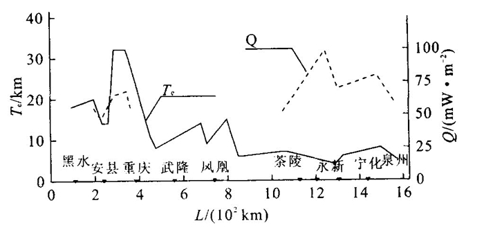
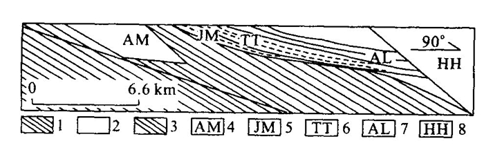
The effective lithospheric elastic thickness of the continent is an important parameter to examine the large scale structure and analyze the mechanism of isostatic compensation within the plate, and is a parameter standing for the strength of the lithosphere. The Te values along Quanzhou Heishui, the southeast section of the Arctic Ocean Eurasian continent Pacific Ocean geoscience transect, are estimated by using the coherence technique developed by Forsthy. Studies of the feature of the coherence between gravity and topography suggest that at short wavelengths (6.6-100 km) for each data box that is used to estimate Te, the plate is strong enough to support topographic loads and gravity and topography are uncorrelated; at long wavelengths where the plate is deflected by surface and subsurface loads which are compensated by the flexure model. The high Te values of Sichuan land stone with low heat flow values and the low Te values in Ninghua, Datian with high heat flow values reflect a correlation, with low heat flow values corresponding to high Te values and with high heat flow values corresponding to low Te values. Te values can be divided into two sections: northwest high section and southeast low section. There is roughly a positive correlation between crustal thickness and effective elastic thickness of the lithosphere.
The effective lithospheric elastic thickness of the continent is an important parameter to examine the large scale structure and analyze the mechanism of isostatic compensation within the plate, and is a parameter standing for the strength of the lithosphere. The Te values along Quanzhou Heishui, the southeast section of the Arctic Ocean Eurasian continent Pacific Ocean geoscience transect, are estimated by using the coherence technique developed by Forsthy. Studies of the feature of the coherence between gravity and topography suggest that at short wavelengths (6.6-100 km) for each data box that is used to estimate Te, the plate is strong enough to support topographic loads and gravity and topography are uncorrelated; at long wavelengths where the plate is deflected by surface and subsurface loads which are compensated by the flexure model. The high Te values of Sichuan land stone with low heat flow values and the low Te values in Ninghua, Datian with high heat flow values reflect a correlation, with low heat flow values corresponding to high Te values and with high heat flow values corresponding to low Te values. Te values can be divided into two sections: northwest high section and southeast low section. There is roughly a positive correlation between crustal thickness and effective elastic thickness of the lithosphere.


2002, 27(4): 403-407.
Abstract:
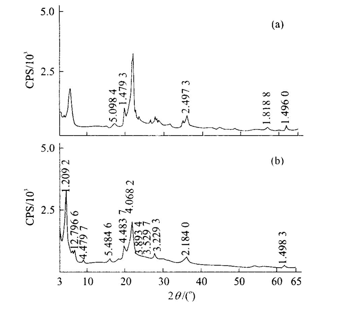
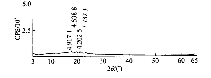
This paper proposes a new method to synthesize the epoxy resin/zeolite nanocomposite. In this method, zeolite was previously treated with sodium nitrate, and organized with ceyltrimethyl ammonium bromide. Epoxy resin was interposed in the cavity of zeolite and polymerized in situ. Then, the polymer mixtures were solidified by pp' diaphenyl methane to prepare for nanocomposite. The synthesis condition such as mixing temperature, mixing time and concentrations are discussed extensively, and the epoxy resin/zeolite nanocomposite was characterized by XRD and TEM. This composite is found to be formed by the nanometer aggregated particles, ranging from 50 to 60 nm in diameter based on the analysis of the TEM image. The epoxy resin/zeolite nanocomposite exhibits dramatic increases in their mechanical properties, which can be used in engineering plastic and high quality adhesive.
This paper proposes a new method to synthesize the epoxy resin/zeolite nanocomposite. In this method, zeolite was previously treated with sodium nitrate, and organized with ceyltrimethyl ammonium bromide. Epoxy resin was interposed in the cavity of zeolite and polymerized in situ. Then, the polymer mixtures were solidified by pp' diaphenyl methane to prepare for nanocomposite. The synthesis condition such as mixing temperature, mixing time and concentrations are discussed extensively, and the epoxy resin/zeolite nanocomposite was characterized by XRD and TEM. This composite is found to be formed by the nanometer aggregated particles, ranging from 50 to 60 nm in diameter based on the analysis of the TEM image. The epoxy resin/zeolite nanocomposite exhibits dramatic increases in their mechanical properties, which can be used in engineering plastic and high quality adhesive.


2002, 27(4): 409-412.
Abstract:
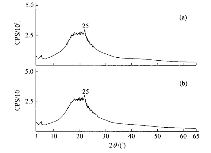
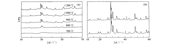
Nano fluorescent powder of Y4Al2 O9: Eu3+ is synthesized by sol gel method. The XRD shows that the production prepared at 900 ℃ is pure phase Y4Al2 O9: Eu3+. Y4Al2 O9 powder is a nano crystal testified by BF and ED analyses of TEM. The grain diameter of Y4Al2 O9 ranges from 20 to 50 nm, averaged at 30 nm. The luminescent spectra show that Eu3+ ions occupy two kinds of sites in Y4Al2 O9 crystal lattice, one in the strict inversion center, and the other in off lying inversion center. When excited with UV light (λ =254 nm), Y4Al2 O9: Eu3+ exhibits the orange emission band at λ =590 nm due to the 5D0→ 7F1 transition and the red emission band at λ =610 nm due to the 5D0→ 7F2 transition.
Nano fluorescent powder of Y4Al2 O9: Eu3+ is synthesized by sol gel method. The XRD shows that the production prepared at 900 ℃ is pure phase Y4Al2 O9: Eu3+. Y4Al2 O9 powder is a nano crystal testified by BF and ED analyses of TEM. The grain diameter of Y4Al2 O9 ranges from 20 to 50 nm, averaged at 30 nm. The luminescent spectra show that Eu3+ ions occupy two kinds of sites in Y4Al2 O9 crystal lattice, one in the strict inversion center, and the other in off lying inversion center. When excited with UV light (λ =254 nm), Y4Al2 O9: Eu3+ exhibits the orange emission band at λ =590 nm due to the 5D0→ 7F1 transition and the red emission band at λ =610 nm due to the 5D0→ 7F2 transition.


2002, 27(4): 413-424.
Abstract:
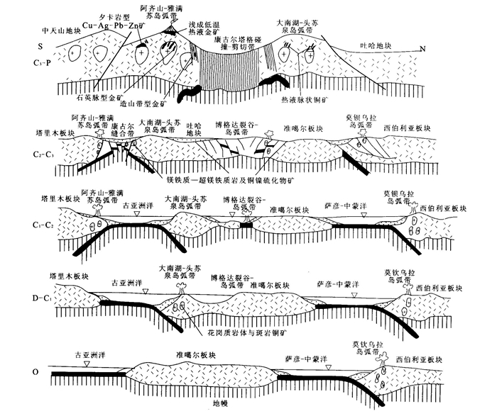
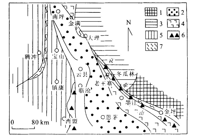
In the past several years, a number of copper, gold and Cu Ag Pb Zn deposits have been discovered and explored in the eastern Tianshan area, Xinjiang. All of the metallic deposits are spatially and densely distributed within the Devonian Late Carboniferous island arc in the north and Carboniferous island arc in the south along the Kangguer Huangshan Carboniferous Permian suture large scale shear zone. These deposits, formed temporally in Carboniferous Permian, can be grouped into gold deposit system comprising epithermal, orogenic and quartz vein types, copper deposit system, porphyry, skarn and hydrothermal vein types, and Cu Ni sulfide system. The three metallogenic systems are genetically associated with the emplacements and eruptions of mafic ultramafic or intermediate felsic magmas during the subduction and extension of post collision of the plates.
In the past several years, a number of copper, gold and Cu Ag Pb Zn deposits have been discovered and explored in the eastern Tianshan area, Xinjiang. All of the metallic deposits are spatially and densely distributed within the Devonian Late Carboniferous island arc in the north and Carboniferous island arc in the south along the Kangguer Huangshan Carboniferous Permian suture large scale shear zone. These deposits, formed temporally in Carboniferous Permian, can be grouped into gold deposit system comprising epithermal, orogenic and quartz vein types, copper deposit system, porphyry, skarn and hydrothermal vein types, and Cu Ni sulfide system. The three metallogenic systems are genetically associated with the emplacements and eruptions of mafic ultramafic or intermediate felsic magmas during the subduction and extension of post collision of the plates.


2002, 27(4): 425-434.
Abstract:
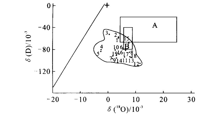
We studied geologic and geochemical characteristics and physical chemical condition of the Au (Cu) ore fluid, bordering the orogenic belt of the Simao Nanping basin. The studies of isotopic tracing on H-O, C-O, He-Ar, T and p, composition in the mineral inclusions testing and their physical chemical parameter calculation in the fluid inclusion indicate that ore forming fluid is derived from meteoric water and that the ore forming materials may be from crustal source and other origin fluid joined. The fluid presents some characteristics such as epithermal, high salinity, alkalescency and deoxidizescency, Na+ > K+ and Ca2++Mg2+, Cl- > F- in the compositions. In the fluid, S2- is dominated and plays a key role in transference and precipitation of Au. The hydrodynamic field and discharge conditions are simulated by paleo hydrogeologic method with a stress on the control of migration and distribution pattern of paleo hydrodynamics field over the multi genetic ore fluid. The ore fluid of high energy and high degree of mineralization is discharged in the low hydrodynamics pressure area and precipitated to form the ore after a long time of repeated leaching and permeation, driven by magmatic dynamics and tectonics.
We studied geologic and geochemical characteristics and physical chemical condition of the Au (Cu) ore fluid, bordering the orogenic belt of the Simao Nanping basin. The studies of isotopic tracing on H-O, C-O, He-Ar, T and p, composition in the mineral inclusions testing and their physical chemical parameter calculation in the fluid inclusion indicate that ore forming fluid is derived from meteoric water and that the ore forming materials may be from crustal source and other origin fluid joined. The fluid presents some characteristics such as epithermal, high salinity, alkalescency and deoxidizescency, Na+ > K+ and Ca2++Mg2+, Cl- > F- in the compositions. In the fluid, S2- is dominated and plays a key role in transference and precipitation of Au. The hydrodynamic field and discharge conditions are simulated by paleo hydrogeologic method with a stress on the control of migration and distribution pattern of paleo hydrodynamics field over the multi genetic ore fluid. The ore fluid of high energy and high degree of mineralization is discharged in the low hydrodynamics pressure area and precipitated to form the ore after a long time of repeated leaching and permeation, driven by magmatic dynamics and tectonics.


2002, 27(4): 435-440.
Abstract:
There is rich resources of low mature oil in Gunan sag, Jiyang depression. The low mature oil is characterized by high content of gammacerane, predominance of phytane and low maturity. The oil shale and oil mudstone with abundant algal matter in the first member of Shahejie Formation of Lower Tertiary is considered as the source rock of the low mature oil. The oil is distributed around the source area and concentrated in the first and second members of Shahejie Formation. The fault controls the migration distance and reservoir beds. There are three reservoir models: self sourced and lateral migration, self sourced and vertical migration through fault, as well as hybrid migration. The lateral migration and charge into lithologic faulted block trap led to the single sourced accumulation inside Gunan basin, while vertical migration and charge into faulted trap caused hybrid sourced accumulation in the marginal faulted zone of the basin.
There is rich resources of low mature oil in Gunan sag, Jiyang depression. The low mature oil is characterized by high content of gammacerane, predominance of phytane and low maturity. The oil shale and oil mudstone with abundant algal matter in the first member of Shahejie Formation of Lower Tertiary is considered as the source rock of the low mature oil. The oil is distributed around the source area and concentrated in the first and second members of Shahejie Formation. The fault controls the migration distance and reservoir beds. There are three reservoir models: self sourced and lateral migration, self sourced and vertical migration through fault, as well as hybrid migration. The lateral migration and charge into lithologic faulted block trap led to the single sourced accumulation inside Gunan basin, while vertical migration and charge into faulted trap caused hybrid sourced accumulation in the marginal faulted zone of the basin.


2002, 27(4): 441-445.
Abstract:
Gas hydrates are quasi stable and sensitive for the changes of pt conditions under various geological processes. Deposition or erosion, sea level fluctuation and the exchange of glacier interglacier alter the pt conditions on sea floor, so that affect the formation or dissociation of gas hydrates. Sudden depositing (especially accumulating by submarine sliding and mud volcano erupting), sea level rising and glacier occuring in high latitude usually make the pressure higher and the temperature lower. These are propitious for the formation and existence of gas hydrate; on the contrary, quickly eroding, sea level dropping and removing of ice cover usually cause the dissociation of gas hydrates. The dissociation can take place gradually or explosively, depending on how fast the pressure drops or the temperature increases. The "explosive dissociation" brings a lots of "pockmmarks" on the sea floor. A consequence of frequently varying pt conditions in an area enriches ethane in gas hydrates.
Gas hydrates are quasi stable and sensitive for the changes of pt conditions under various geological processes. Deposition or erosion, sea level fluctuation and the exchange of glacier interglacier alter the pt conditions on sea floor, so that affect the formation or dissociation of gas hydrates. Sudden depositing (especially accumulating by submarine sliding and mud volcano erupting), sea level rising and glacier occuring in high latitude usually make the pressure higher and the temperature lower. These are propitious for the formation and existence of gas hydrate; on the contrary, quickly eroding, sea level dropping and removing of ice cover usually cause the dissociation of gas hydrates. The dissociation can take place gradually or explosively, depending on how fast the pressure drops or the temperature increases. The "explosive dissociation" brings a lots of "pockmmarks" on the sea floor. A consequence of frequently varying pt conditions in an area enriches ethane in gas hydrates.


2002, 27(4): 446-452.
Abstract:
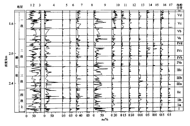
This paper reports our primary effort in quantitatively reconstructing paleoclimate based on the niche of the affinity parent plants in the stratigraphic pollen record. Eocene pollen data come from our former study on the core Mingjia 1 in the Jianghan basin. The changing trend in the parameter curve of climate shows that the middle Eocene climate in the Jianghan basin is more or less comparable with that of the present 22°-26°N, reflecting a humid, semi humid central southern subtropical climate. The annual temperature then declined 1-4 ℃ lower at the late Eocene, approximately equal to the present 23°-28°N of northern central subtropical climate. However, the climate composite at that time was different from the present one, and was characterized by higher temperature, small annual range, and big fluctuation in precipitation. The January average temperature in the middle Eocene was 5-9 ℃ higher than that of today, indicating that there was no winter monsoon influence in the middle Eocene, though it may have partly happened in late Eocene. Major temperature decline is recognized at depth 2 100 m of the core, as was indicated by the decline in January average temperature and an increase in annual range. It is also indicated by the increase of the deciduous broad leaved types in the pollen assemblage. The sharp fluctuation in the annual precipitation, raging from 300 to 1 700 mm, was favorable for the migration and accumulation of salty deposits. When the precipitation was lower than 1 000 mm, ephedra shrub increased, which happened in the same depth with the salty deposit. It is deduced that the dry and hot environment in the high mountain and deep basin could have been the main reason for the formation of the salty deposit in the core. The annual precipitation was not very lower at that time, and this is different from the present salty deposit in Northwest China.
This paper reports our primary effort in quantitatively reconstructing paleoclimate based on the niche of the affinity parent plants in the stratigraphic pollen record. Eocene pollen data come from our former study on the core Mingjia 1 in the Jianghan basin. The changing trend in the parameter curve of climate shows that the middle Eocene climate in the Jianghan basin is more or less comparable with that of the present 22°-26°N, reflecting a humid, semi humid central southern subtropical climate. The annual temperature then declined 1-4 ℃ lower at the late Eocene, approximately equal to the present 23°-28°N of northern central subtropical climate. However, the climate composite at that time was different from the present one, and was characterized by higher temperature, small annual range, and big fluctuation in precipitation. The January average temperature in the middle Eocene was 5-9 ℃ higher than that of today, indicating that there was no winter monsoon influence in the middle Eocene, though it may have partly happened in late Eocene. Major temperature decline is recognized at depth 2 100 m of the core, as was indicated by the decline in January average temperature and an increase in annual range. It is also indicated by the increase of the deciduous broad leaved types in the pollen assemblage. The sharp fluctuation in the annual precipitation, raging from 300 to 1 700 mm, was favorable for the migration and accumulation of salty deposits. When the precipitation was lower than 1 000 mm, ephedra shrub increased, which happened in the same depth with the salty deposit. It is deduced that the dry and hot environment in the high mountain and deep basin could have been the main reason for the formation of the salty deposit in the core. The annual precipitation was not very lower at that time, and this is different from the present salty deposit in Northwest China.

2002, 27(4): 453-455.
Abstract:
Speleothems contains abundant paleoclimatic information and the correct interpretation depends on the development of various paleoclimatic proxies. In this paper, an improved reduced molybdosilicic acid spectrophotometry is used to measure trace dissolved silicon in a stalagmite from Zha cave, Qingjiang, Hubei Province and reveals its indication of the paleoclimate. It is discovered that a 9 000 a dissolved silicon may have recorded the variability of local groundwater chemistry composition. Under the chemical weathering process, the dissolved silicon originated from the silicate in soil is found to be controlled by the weather condition. Therefore, the dissolved silicon may be a potential proxy for paleoclimate, especially for ancient moisture.
Speleothems contains abundant paleoclimatic information and the correct interpretation depends on the development of various paleoclimatic proxies. In this paper, an improved reduced molybdosilicic acid spectrophotometry is used to measure trace dissolved silicon in a stalagmite from Zha cave, Qingjiang, Hubei Province and reveals its indication of the paleoclimate. It is discovered that a 9 000 a dissolved silicon may have recorded the variability of local groundwater chemistry composition. Under the chemical weathering process, the dissolved silicon originated from the silicate in soil is found to be controlled by the weather condition. Therefore, the dissolved silicon may be a potential proxy for paleoclimate, especially for ancient moisture.

2002, 27(4): 456-458.
Abstract:
It is well known that paleoflood predictions must base on its occurrence. But our available records do not provide long enough temporal scale for identification and grasp the emergence law of flood events. So it is very important and necessary to discuss the characters of floods during the characteristic climatic period using geological records. The flood record of Lanzhou Yinchuan reach in upper Yellow River reveals 106 flood events, with a frequency of 53 per ka, during 20 to 18 ka including 18 complex floods superposed by multiple flood peaks. These paleoflood probably belonging to ice slush floods are associated with abrupt and extreme climatic oscillation and instability of this stage. The high frequency of these paleoflood is consistent with high lake surface of western China in course of last glacial maximum. It is neither in accordance with the monsoon theory nor different from the climatic feature of eastern areas typical of cold and dry climate. This indicates the climate complexity and particularity of western China.
It is well known that paleoflood predictions must base on its occurrence. But our available records do not provide long enough temporal scale for identification and grasp the emergence law of flood events. So it is very important and necessary to discuss the characters of floods during the characteristic climatic period using geological records. The flood record of Lanzhou Yinchuan reach in upper Yellow River reveals 106 flood events, with a frequency of 53 per ka, during 20 to 18 ka including 18 complex floods superposed by multiple flood peaks. These paleoflood probably belonging to ice slush floods are associated with abrupt and extreme climatic oscillation and instability of this stage. The high frequency of these paleoflood is consistent with high lake surface of western China in course of last glacial maximum. It is neither in accordance with the monsoon theory nor different from the climatic feature of eastern areas typical of cold and dry climate. This indicates the climate complexity and particularity of western China.

2002, 27(4): 459-463.
Abstract:
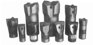
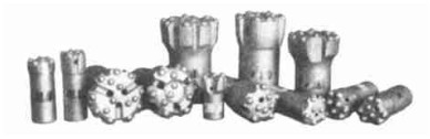
Flying dragon" ϕ40 and ϕ42-4P1C insert and button complex type bits have developed the strong points and avoided the weak points of traditional ones bits. When they are used with new G308, YJ2.1R cemented carbide for rock drilling tools with extreme toughness, their service life is three times as much as that of the chisel bits set YG11C insert now used widely in China. At the same time, they maintain remarkable characteristics of high drilling speed and low consumption and will be likely to replace other bits.
Flying dragon" ϕ40 and ϕ42-4P1C insert and button complex type bits have developed the strong points and avoided the weak points of traditional ones bits. When they are used with new G308, YJ2.1R cemented carbide for rock drilling tools with extreme toughness, their service life is three times as much as that of the chisel bits set YG11C insert now used widely in China. At the same time, they maintain remarkable characteristics of high drilling speed and low consumption and will be likely to replace other bits.


2002, 27(4): 464-466.
Abstract:
Based on the deep geology and the geological structure characteristics of the ancient landslide body, a geo environmental model of Huangtupo landslide in the reservoir of Three Gorges is established to quantitatively analyze the mechanism of the sliding in terms of discrete element method. It is concluded that inter bedding structure of soft and hard formation consists of the main geological background, which induced the arching of the formation under gravity. Stability analysis by considering different loadings shows that ground building load in the middle can restrain the development of shear sliding zone in the middle, but may extend the shear sliding zone at the foot area which will reduce the safety of the front.
Based on the deep geology and the geological structure characteristics of the ancient landslide body, a geo environmental model of Huangtupo landslide in the reservoir of Three Gorges is established to quantitatively analyze the mechanism of the sliding in terms of discrete element method. It is concluded that inter bedding structure of soft and hard formation consists of the main geological background, which induced the arching of the formation under gravity. Stability analysis by considering different loadings shows that ground building load in the middle can restrain the development of shear sliding zone in the middle, but may extend the shear sliding zone at the foot area which will reduce the safety of the front.