2002 Vol. 27, No. 5
Display Method:
2002, 27(5): 467-481.
 PDF 419KB
Abstract:
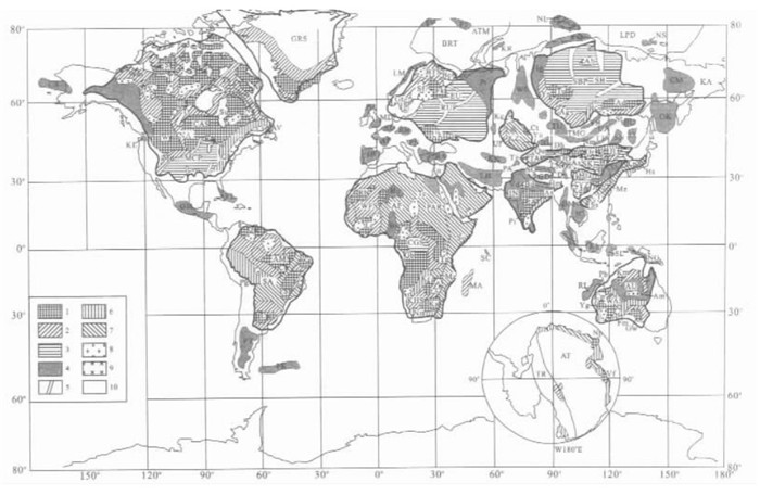
The tectonic frame and subdivision of tectonic units of the world Precambrian basement are essential for paleocontinent reconstruction. In this paper, a three rank system of tectonic units, the first rank tectonic domain, the second rank craton (continental platform) or 'Region', and the third rank continental nucleus, massif and belt, is proposed, based mainly on situations in Neoproterozoic Jinning and the Early Mesozoic Indosinian epochs. Altogether 5 domains, 14 cratons or regions, and a number of nuclei, massifs and belts within and outside of the cratons that are related to or derived from the cratons, are distinguished and catalogued for further reference and improvement (Fig. 1 , Table 1 ). We deem that a supercontinent is a constituent part of its contemporary pangea, and the present research of supercontinent Rodinia has entered into the study of its contemporary pangea, the Pangea-850 in our former use. In the early Neoproterozoic, the three Chinese cratons, Sino-Korean, Yangtzean, Tarimian and the Cathaysian Region, were probably partly collided with each other through the Jinningian orogeny, and were not very far from each other. We have called the combined entirety, including the Central Asian Karakum Massif, the Axial Asian or Cathaysianan Do-main. The current models for Rodinia, especially the SWEAT connection, are discussed. As the characteristic Neo-proterozoic (900-850 Ma) Qingbaikouan mega algae Chuaria-Tawuia assemblage were amply found both in Sino-Korea and Cathaysian in eastern Asia and in the Little Dal Group in western North America, we suggest the Axial Asian or Cathaysianan Domain may have been placed near the western margin of Laurentia, and the East Gondwanan cratons may on that account be shifted southwards (on map). Other problems including the orientation of the Siberian Craton and the Pan-African belts in the West Gondwanan Domain are also briefly noted. A refined reconstruction of the Middle Permian Epoch (280-257 Ma) for Pangea-250, the only recognized Pangea up to now, is presented, in which three marine biogeographical realms and constituent provinces based mainly on corals and brachiopods are subdi-vided. The signals for the four well known paleophytic realms, Angaran, Cathaysian, Euramerican and Gondwanan, and of some representative assemblages of the marine provinces are shown on Fig. 3 , and their significance in paleo-continent reconstruction are briefly discussed.
The tectonic frame and subdivision of tectonic units of the world Precambrian basement are essential for paleocontinent reconstruction. In this paper, a three rank system of tectonic units, the first rank tectonic domain, the second rank craton (continental platform) or 'Region', and the third rank continental nucleus, massif and belt, is proposed, based mainly on situations in Neoproterozoic Jinning and the Early Mesozoic Indosinian epochs. Altogether 5 domains, 14 cratons or regions, and a number of nuclei, massifs and belts within and outside of the cratons that are related to or derived from the cratons, are distinguished and catalogued for further reference and improvement (


2002, 27(5): 482-489.
Abstract:
With the rapid progress of IT, the mineral exploration has already entered into a new period of digiti-zation and quantification. The "three-component" mineral prediction and resource assessments are suggested as a new approach to the "digital mineral prospecting". The "three component" mineral prediction, based on geo-anomaly anal-ysis, is guided by the research into both the diversity of mineralization and the spectrum of mineral deposits. Close combination of these three aspects of quantitative study serves both as a new starting point for digital prospecting and as a foundation and prerequisite for IT application in this field.
With the rapid progress of IT, the mineral exploration has already entered into a new period of digiti-zation and quantification. The "three-component" mineral prediction and resource assessments are suggested as a new approach to the "digital mineral prospecting". The "three component" mineral prediction, based on geo-anomaly anal-ysis, is guided by the research into both the diversity of mineralization and the spectrum of mineral deposits. Close combination of these three aspects of quantitative study serves both as a new starting point for digital prospecting and as a foundation and prerequisite for IT application in this field.


2002, 27(5): 490-497.
Abstract:
The International Commission on Stratigraphy proposed that all stratotypes between the chronostratigraphic stages should be selected in the coming years. The China National Commission on Stratigraphy suggested a scheme of the Chinese chronostratigraphic stages of all the systems at the third National Stratigraphic Conference in 2000. Therefore, the stage-based stratigraphic study is the focus of the current stratigraphic studies. This paper introduces both the scheme of the international Triassic chronostratigraphic division and the history of the scheme selection. The outline of the Chinese marine Triassic stages is stated as well in this paper, with an emphasis on the definition and recognizable markers of the top and basal boundaries of the Lower Triassic stages. The current key aspects in the study of the Chinese Lower Triassic stages are also suggested in this paper.
The International Commission on Stratigraphy proposed that all stratotypes between the chronostratigraphic stages should be selected in the coming years. The China National Commission on Stratigraphy suggested a scheme of the Chinese chronostratigraphic stages of all the systems at the third National Stratigraphic Conference in 2000. Therefore, the stage-based stratigraphic study is the focus of the current stratigraphic studies. This paper introduces both the scheme of the international Triassic chronostratigraphic division and the history of the scheme selection. The outline of the Chinese marine Triassic stages is stated as well in this paper, with an emphasis on the definition and recognizable markers of the top and basal boundaries of the Lower Triassic stages. The current key aspects in the study of the Chinese Lower Triassic stages are also suggested in this paper.
2002, 27(5): 498-503.
Abstract:
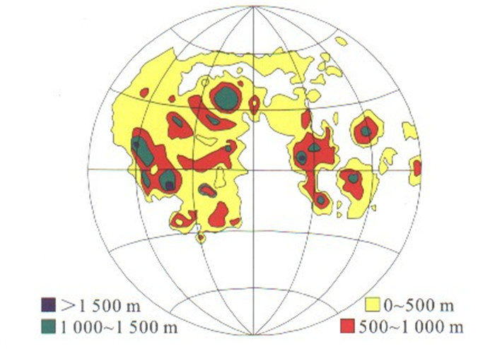
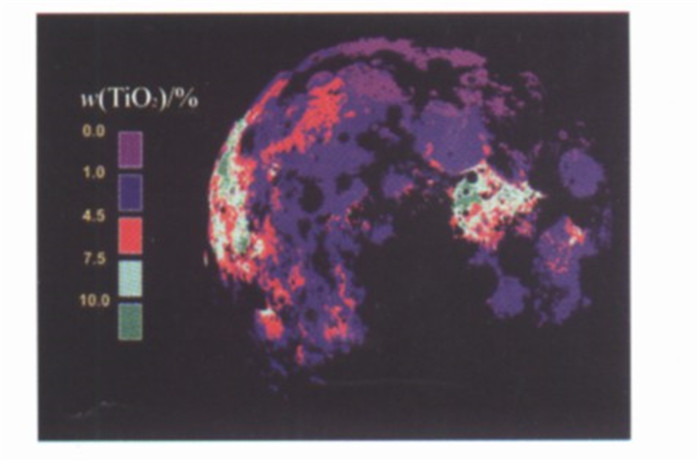
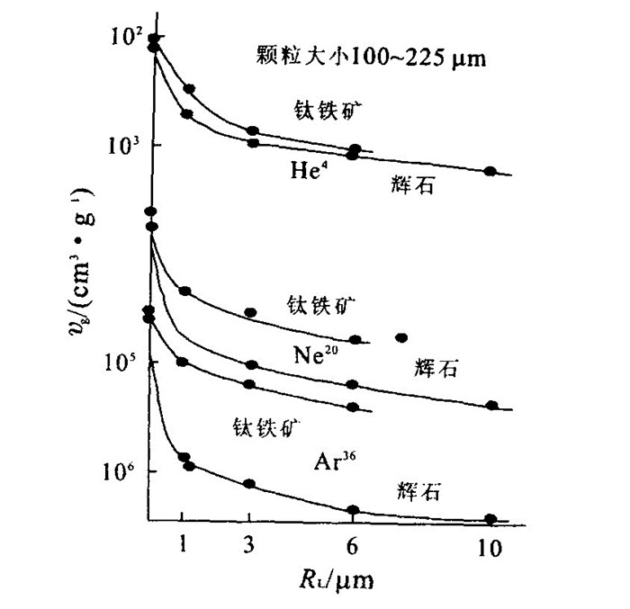
The establishment of the lunar base is the main trend of the lunar exploration and detection in the 21st century, because the exploration and utilization of the lunar mineral resources, energy and specific environment will effectively support the sustainable development of human society. The authors make a systematic study of the distributions and contents of ilmenitite in lunar basalts, those of U, Th, REE in KREEP rocks and those of He 3 in the lunar regolith. Then the authors show two points: (1) More than 70 000 billion tons of titanium dioxide occur in lunar basalts. The ilmenitite is the major raw material for the production of water and missile fuel in the lunar base. (2) KREEP rocks, one of the hot issues for the detection of and research into the lunar planet, contain a gigantic mount of uranium, thorium, calcium, phosphorus and rare earth elements. The lunar regolith has been affected by the solar wind for a long time, so that it contains such abundant gas resources as hydrogen, helium, oxygen and nitrogen. In particular, the He 3, amounting to over 1 million tons, is a kind of nuclear fusion fuel for the production of electrical power. This kind of fuel, safe, clean, highly efficient and cheap, can be applied to the human society for a long time. The content of helium is closely associated with the chemical composition, mineral assemblage and grain size of the lunar regolith.
The establishment of the lunar base is the main trend of the lunar exploration and detection in the 21st century, because the exploration and utilization of the lunar mineral resources, energy and specific environment will effectively support the sustainable development of human society. The authors make a systematic study of the distributions and contents of ilmenitite in lunar basalts, those of U, Th, REE in KREEP rocks and those of He 3 in the lunar regolith. Then the authors show two points: (1) More than 70 000 billion tons of titanium dioxide occur in lunar basalts. The ilmenitite is the major raw material for the production of water and missile fuel in the lunar base. (2) KREEP rocks, one of the hot issues for the detection of and research into the lunar planet, contain a gigantic mount of uranium, thorium, calcium, phosphorus and rare earth elements. The lunar regolith has been affected by the solar wind for a long time, so that it contains such abundant gas resources as hydrogen, helium, oxygen and nitrogen. In particular, the He 3, amounting to over 1 million tons, is a kind of nuclear fusion fuel for the production of electrical power. This kind of fuel, safe, clean, highly efficient and cheap, can be applied to the human society for a long time. The content of helium is closely associated with the chemical composition, mineral assemblage and grain size of the lunar regolith.


2002, 27(5): 504-508.
Abstract:
In Taibei depression, the diagenetic evolution of the clay minerals indicates that the smectite in smectite/illite mixed layer is associated with the basic normal genetic variation with depth. However, the other clay minerals are associated with various anomalous phenomena at different diagenetic stages. The detailed investigation of diagenesis in Shanshan structure indicates that several factors, such as sedimentary provenance, aqueous medium, acidic fluid generated by diagenesis of coal measure strata, organic acid generated in the course of thermal evolution and organic acid existing in oil layer, are responsible for the anomalous variation of the clay minerals at different diagenetic stages. These factors have resulted, to different extents, in anomalous development of the clay minerals at different diagenetic stages in this region.
In Taibei depression, the diagenetic evolution of the clay minerals indicates that the smectite in smectite/illite mixed layer is associated with the basic normal genetic variation with depth. However, the other clay minerals are associated with various anomalous phenomena at different diagenetic stages. The detailed investigation of diagenesis in Shanshan structure indicates that several factors, such as sedimentary provenance, aqueous medium, acidic fluid generated by diagenesis of coal measure strata, organic acid generated in the course of thermal evolution and organic acid existing in oil layer, are responsible for the anomalous variation of the clay minerals at different diagenetic stages. These factors have resulted, to different extents, in anomalous development of the clay minerals at different diagenetic stages in this region.


2002, 27(5): 509-519.
Abstract:
The natural philosophical conception that "the geological process and spatio temporal structure are the essence and crux of geological phenomena" proposed by the author can be used to classify the geological science as four major academic disciplines: the composition and structure of the earth materials, the geological process, the geological field and the evolution of the geosystem. These four major academic disciplines correspond to the nine important basic geological issues and associated complex theoretical problems (Table 2). The author applies the complex theory of geological science "the dynamics of the self organized critical process of geological process - the fractal growth of geosystems at the edge of chaos" proposed by the author himself to the research into the nine important basic geological issues, with an emphasis on the relatively deep and brief analysis of the nature, theory and research method of the major basic theoretical problems. The purpose of the paper is to understand the geological sciences, old and renewed frequently, from the new point of view of the complexity of geosystem considered as the basic problem of geological sciences, to raise the study of basic geological problems to the level of the nonlinear science and the theory of complexity, and to complete the transformation of the geological science into a precise science, with an expectation to make a breakthrough in geological process.
The natural philosophical conception that "the geological process and spatio temporal structure are the essence and crux of geological phenomena" proposed by the author can be used to classify the geological science as four major academic disciplines: the composition and structure of the earth materials, the geological process, the geological field and the evolution of the geosystem. These four major academic disciplines correspond to the nine important basic geological issues and associated complex theoretical problems (Table 2). The author applies the complex theory of geological science "the dynamics of the self organized critical process of geological process - the fractal growth of geosystems at the edge of chaos" proposed by the author himself to the research into the nine important basic geological issues, with an emphasis on the relatively deep and brief analysis of the nature, theory and research method of the major basic theoretical problems. The purpose of the paper is to understand the geological sciences, old and renewed frequently, from the new point of view of the complexity of geosystem considered as the basic problem of geological sciences, to raise the study of basic geological problems to the level of the nonlinear science and the theory of complexity, and to complete the transformation of the geological science into a precise science, with an expectation to make a breakthrough in geological process.


2002, 27(5): 522-531.
Abstract:
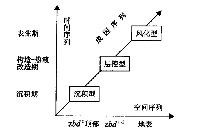
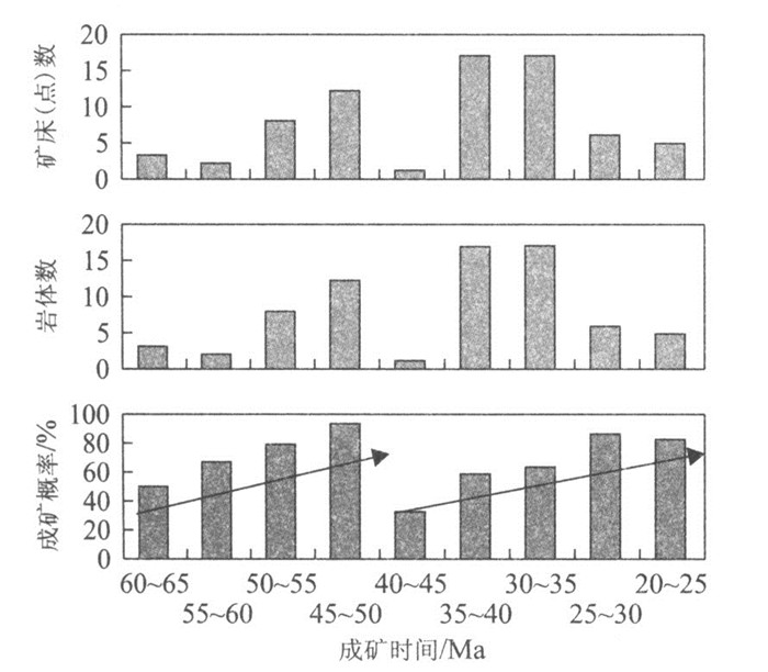
The greenstone belt type gold deposit in the North China craton (NCC), one of the most important deposit types in China, is the major source of gold productions and reserves. In terms of geodynamics, the NCC has experienced several tectonic stages ranging from the Middle and Upper Proterozoic divergent epicontinents, the Lower to Upper Paleozoic convergent epicontinents, to the Phanerozoic Mesozoic craton activation. This type of gold deposit, formed mainly in the craton activation stage, occurred in the transitional period from a compressive regime of late or post collision to an extension one. Gold mineralization occurred in a favorable regional geochemical setting (fairly high abundance of gold). Although these deposits were formed in different Phanerozoic periods, with the majority of these deposits in the Late Yanshanian, they share similar geological and geochemical features, and are spatially, temporally and genetically related to Phanerozoic granitic intrusions. Geochronological data suggest that gold mineralization is coeval with, or slightly postdates, the emplacement of the associated granites, probably indicating that gold mineralization is likely a product of the late stage of tectono magmatism. Therefore, the major gold deposits in the NCC can be considered as a single metallogenic system, i.e., hydrothermal metallogenic system related to granitic magmatism in greenstone belts.
The greenstone belt type gold deposit in the North China craton (NCC), one of the most important deposit types in China, is the major source of gold productions and reserves. In terms of geodynamics, the NCC has experienced several tectonic stages ranging from the Middle and Upper Proterozoic divergent epicontinents, the Lower to Upper Paleozoic convergent epicontinents, to the Phanerozoic Mesozoic craton activation. This type of gold deposit, formed mainly in the craton activation stage, occurred in the transitional period from a compressive regime of late or post collision to an extension one. Gold mineralization occurred in a favorable regional geochemical setting (fairly high abundance of gold). Although these deposits were formed in different Phanerozoic periods, with the majority of these deposits in the Late Yanshanian, they share similar geological and geochemical features, and are spatially, temporally and genetically related to Phanerozoic granitic intrusions. Geochronological data suggest that gold mineralization is coeval with, or slightly postdates, the emplacement of the associated granites, probably indicating that gold mineralization is likely a product of the late stage of tectono magmatism. Therefore, the major gold deposits in the NCC can be considered as a single metallogenic system, i.e., hydrothermal metallogenic system related to granitic magmatism in greenstone belts.


2002, 27(5): 532-533.
Abstract:
Isotope hydrology is a new discipline in earth sciences developed since 1950s. Its main target is to use isotope technique to solve various problems in hydrology. It is well known that isotope refers to those atoms whose numbers of proton are the same but whose numbers of neutron are different. Isotopes can be divided into two types: stable and radioactive. For stable isotopes, no radioactive decay has been found so far. But for radioactive isotope, there exists radioactive decay. Usually, the term "natural" and/or "environmental" isotopes were used for the two types of isotope mentioned above. The environmental isotopes commonly used in hydrology are: 2H, 3H, 3He, 4He, 13C, 14C, 18O, 34S, 36Cl, etc. It must be noted that for different types of water, such as sea water, lake water, river water and ground water, the isotope composition seems to be quite different but relatively stable, although the water chemistry varies greatly. Therefore, the isotope composition can be, to certain degree, regarded as the "finger print" and/or "DNA" of the water. Also for this reason, the isotope composition in the water and the isotope hydrology technique are widely used to solve various problems in water resources assessment and hydro environment evaluations such as the origin of water, the interaction of surface and groundwater, the rain off water, the degree of openness of a groundwater system, the intensity of water cycling, the pollution degree and the pollution source of a water body. In recognition of the importance of isotope hydrology, an isotope hydrology section has been established in the International Atomic Energy Agency (IAEA) and an isotope hydrology laboratory is set up simultaneously with advanced technique and equipment. Since late 1950s, a Global Network for Isotopes in Precipitation (GNIP) has been initiated jointly by IAEA and WMO (World Meteorological Organization) and all the data have been published since 1961. Recently, sponsored by IAEA/UNESCO, a similar global network for isotopes in the large rivers in the world is under the way to set up. It is of significant importance in promoting isotope hydrology development worldwide. In China, isotope hydrology studies can be traced back to the late 1960s. In the scientific investigation of water resources in Jolmo Lungma region, 2H and 18O were determined in snow and ice samples. Since then, 2H and 18O have been analyzed for precipitations in Beijing, Shanghai and East China by different researchers with great achievement. In 1988, Supported by the Ministry of Water Resources, the first 10 stations, for monitoring the isotopes in precipitation in China were established and now they have been included in the IAEA/WMO GNIP. At present, the total number of stations has increased to 30.Nowadays, water resources shortage and hydro environments degradation become more and more serious worldwide. According to the prediction by the World Bank, 2/3 world population will live in a serious water shortage environment if we follow the present water consuming model. At present, 70-80 billions of US dollars has been offered to the developing countries to alleviate the annual water resources shortage. The global demand for water resources will be doubled in the coming 15 years. For this reason, altogether 24 international organizations including IAEA are working on a World Project for Water Resources Assessment to reduce the global water shortage. "flood", "water shortage" and "water pollution" have become three main problems in China nowadays. Both the water shortages in the Heihe river region and the degradation of hydro environment in Taihu lake area have attracted great attention from the State Council. The isotope hydrology technique may play a particular role in solving these problems. All in all, opportunities and challenges co exist and it is a right time to expedite the development of isotope hydrology in China.
Isotope hydrology is a new discipline in earth sciences developed since 1950s. Its main target is to use isotope technique to solve various problems in hydrology. It is well known that isotope refers to those atoms whose numbers of proton are the same but whose numbers of neutron are different. Isotopes can be divided into two types: stable and radioactive. For stable isotopes, no radioactive decay has been found so far. But for radioactive isotope, there exists radioactive decay. Usually, the term "natural" and/or "environmental" isotopes were used for the two types of isotope mentioned above. The environmental isotopes commonly used in hydrology are: 2H, 3H, 3He, 4He, 13C, 14C, 18O, 34S, 36Cl, etc. It must be noted that for different types of water, such as sea water, lake water, river water and ground water, the isotope composition seems to be quite different but relatively stable, although the water chemistry varies greatly. Therefore, the isotope composition can be, to certain degree, regarded as the "finger print" and/or "DNA" of the water. Also for this reason, the isotope composition in the water and the isotope hydrology technique are widely used to solve various problems in water resources assessment and hydro environment evaluations such as the origin of water, the interaction of surface and groundwater, the rain off water, the degree of openness of a groundwater system, the intensity of water cycling, the pollution degree and the pollution source of a water body. In recognition of the importance of isotope hydrology, an isotope hydrology section has been established in the International Atomic Energy Agency (IAEA) and an isotope hydrology laboratory is set up simultaneously with advanced technique and equipment. Since late 1950s, a Global Network for Isotopes in Precipitation (GNIP) has been initiated jointly by IAEA and WMO (World Meteorological Organization) and all the data have been published since 1961. Recently, sponsored by IAEA/UNESCO, a similar global network for isotopes in the large rivers in the world is under the way to set up. It is of significant importance in promoting isotope hydrology development worldwide. In China, isotope hydrology studies can be traced back to the late 1960s. In the scientific investigation of water resources in Jolmo Lungma region, 2H and 18O were determined in snow and ice samples. Since then, 2H and 18O have been analyzed for precipitations in Beijing, Shanghai and East China by different researchers with great achievement. In 1988, Supported by the Ministry of Water Resources, the first 10 stations, for monitoring the isotopes in precipitation in China were established and now they have been included in the IAEA/WMO GNIP. At present, the total number of stations has increased to 30.Nowadays, water resources shortage and hydro environments degradation become more and more serious worldwide. According to the prediction by the World Bank, 2/3 world population will live in a serious water shortage environment if we follow the present water consuming model. At present, 70-80 billions of US dollars has been offered to the developing countries to alleviate the annual water resources shortage. The global demand for water resources will be doubled in the coming 15 years. For this reason, altogether 24 international organizations including IAEA are working on a World Project for Water Resources Assessment to reduce the global water shortage. "flood", "water shortage" and "water pollution" have become three main problems in China nowadays. Both the water shortages in the Heihe river region and the degradation of hydro environment in Taihu lake area have attracted great attention from the State Council. The isotope hydrology technique may play a particular role in solving these problems. All in all, opportunities and challenges co exist and it is a right time to expedite the development of isotope hydrology in China.
2002, 27(5): 534-538.
Abstract:
This paper mainly introduces the best advanced technology and application of controlled directional drilling technology, tunneling engineering and trenchless engineering, and demonstrates that the drilling and tunneling engineering technology is more advanced and scientific due to the developments of the exploration engineering, resulting in the rapid increase in the high tech association. In this sense, the drilling and tunneling engineering technology is not only considered as an engineering technology, but also more as an engineering science.
This paper mainly introduces the best advanced technology and application of controlled directional drilling technology, tunneling engineering and trenchless engineering, and demonstrates that the drilling and tunneling engineering technology is more advanced and scientific due to the developments of the exploration engineering, resulting in the rapid increase in the high tech association. In this sense, the drilling and tunneling engineering technology is not only considered as an engineering technology, but also more as an engineering science.


2002, 27(5): 539-543.
Abstract:
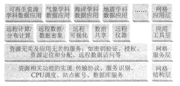
The conception of grid started in 1960's. Due to the rapid development of computer technology-based academic disciplines for the past ten years, the research into the grid technology has entered into an excessively fast-speed period. In addition, the global information science has already experienced many revolutionary changes with the advancement of the computer and remote-sensing technology. Today, the insufficient use of the thousands of Tb or Pb geo-data acquired daily has troubled many earth scientists. However, this trouble can be easily shot by the introduction of grid technology to the geo-data storing and sharing system.
The conception of grid started in 1960's. Due to the rapid development of computer technology-based academic disciplines for the past ten years, the research into the grid technology has entered into an excessively fast-speed period. In addition, the global information science has already experienced many revolutionary changes with the advancement of the computer and remote-sensing technology. Today, the insufficient use of the thousands of Tb or Pb geo-data acquired daily has troubled many earth scientists. However, this trouble can be easily shot by the introduction of grid technology to the geo-data storing and sharing system.
2002, 27(5): 544-548.
Abstract:
In this paper, the diamond metallization and the adding of rare earth elements to the matrix materials are two major methods for the increase in diamond drilling effectiveness, as suggested in authors'experimental research. This increase can be achieved by the application of the drilling at a constant penetration rate based on the footing per cycle. The foam may serve as the flushing medium of the drilling technique.
In this paper, the diamond metallization and the adding of rare earth elements to the matrix materials are two major methods for the increase in diamond drilling effectiveness, as suggested in authors'experimental research. This increase can be achieved by the application of the drilling at a constant penetration rate based on the footing per cycle. The foam may serve as the flushing medium of the drilling technique.


2002, 27(5): 549-557.
Abstract:
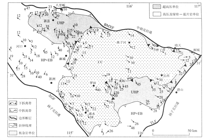
The basic principles of lithospheric rheology and the modern analytical tectonics are used to examine deformational features of the rocks and the processes responsible for their formation and exhumation in the UHP and HP metamorphic belts within the Tongbai-Dabie-Sulu region, China. The discussion is concentrated on high-angle, anastomosing shear zone arrays which were formed under UHP eclogite facies conditions, and related to the Triassic (250-220 Ma) collision between the Sino-Korean and Yangtze cratons, and shear zone assemblages accompanied, following the collision, by decompressional partial melting, formed by a compressional regime on upper amphibolite facies conditions, as well as deformation pictures formed by ductile extension flow and thinning on amphibolite facies conditions, mostly between 200 Ma and 170 Ma. It is suggested that the deformation partitioning plays an important role in the deformational processes for the rocks within the UHP and HP belts, at different crustal levels and on different physical conditions. The efficient strain regime in the UHP and HP metamorphic belts is shear, which is generally localized in networks of ductile shear zones on all scales. On the basis of structural records mainly and combined with the previous data on petrography, pT paths of UHP metamorphic rocks and geochronology, a speculative rheological evolution model for the UHP and HP metamorphic belts is proposed. In this model, 250 to 220 Ma is considered as the most reliable estimated age for the occurrences of both the UHP and HP metamorphism and the continental collision between the Sino-Korean and Yangtze cratons. The major consequence of this collision was the development of a crustal-stacking wedge. The UHP and HP metamorphic rocks were exhumed from the mantle depth to the surface during a multistage history, including wedge intrusion (220-200 Ma), crustal ductile thinning and extension flow (200-170 Ma) and late orogenic collapse and unroofing.
The basic principles of lithospheric rheology and the modern analytical tectonics are used to examine deformational features of the rocks and the processes responsible for their formation and exhumation in the UHP and HP metamorphic belts within the Tongbai-Dabie-Sulu region, China. The discussion is concentrated on high-angle, anastomosing shear zone arrays which were formed under UHP eclogite facies conditions, and related to the Triassic (250-220 Ma) collision between the Sino-Korean and Yangtze cratons, and shear zone assemblages accompanied, following the collision, by decompressional partial melting, formed by a compressional regime on upper amphibolite facies conditions, as well as deformation pictures formed by ductile extension flow and thinning on amphibolite facies conditions, mostly between 200 Ma and 170 Ma. It is suggested that the deformation partitioning plays an important role in the deformational processes for the rocks within the UHP and HP belts, at different crustal levels and on different physical conditions. The efficient strain regime in the UHP and HP metamorphic belts is shear, which is generally localized in networks of ductile shear zones on all scales. On the basis of structural records mainly and combined with the previous data on petrography, pT paths of UHP metamorphic rocks and geochronology, a speculative rheological evolution model for the UHP and HP metamorphic belts is proposed. In this model, 250 to 220 Ma is considered as the most reliable estimated age for the occurrences of both the UHP and HP metamorphism and the continental collision between the Sino-Korean and Yangtze cratons. The major consequence of this collision was the development of a crustal-stacking wedge. The UHP and HP metamorphic rocks were exhumed from the mantle depth to the surface during a multistage history, including wedge intrusion (220-200 Ma), crustal ductile thinning and extension flow (200-170 Ma) and late orogenic collapse and unroofing.


2002, 27(5): 558-564.
Abstract:
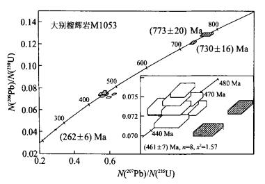
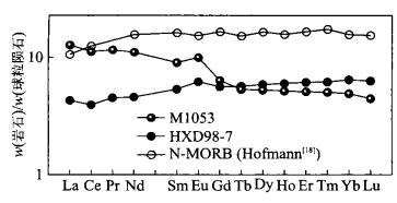
Zircons of eclogites from Xiongdian (Luoshan, Henan) and Mifengjian (Yingshan, Hubei) are dated by the SHRIMP U-Pb method. The Yingshan coesite-bearing ultrahigh-pressure eclogite shows four age groups: (773±20) Ma, (730±16) Ma, (461±7) Ma and (262±6) Ma, with the dominance of the (461±7) Ma group. The Xiongdian high-pressure eclogite shows three age groups of (449±14) Ma, (307±14) Ma and (216±4) Ma. The ca. 450 Ma age is present in eclogites from both localities. They have extremely low Zr (9×10⁻⁶-19×10-6). Together with the MORB-like trace element characteristics and εNd (+6.56 at 450 Ma), the age suggests an early Paleozoic high-and ultrahigh-pressure metamorphic event probably related to the subduction of oceanic crust and associated arc materials. The coexisting Ordovician and Triassic ages in the Xiongdian eclogite also suggest that the northern boundary of the Dabie high and ultrahigh-pressure metamorphic belt, regardless of time, is to the north of Xiongdian.
Zircons of eclogites from Xiongdian (Luoshan, Henan) and Mifengjian (Yingshan, Hubei) are dated by the SHRIMP U-Pb method. The Yingshan coesite-bearing ultrahigh-pressure eclogite shows four age groups: (773±20) Ma, (730±16) Ma, (461±7) Ma and (262±6) Ma, with the dominance of the (461±7) Ma group. The Xiongdian high-pressure eclogite shows three age groups of (449±14) Ma, (307±14) Ma and (216±4) Ma. The ca. 450 Ma age is present in eclogites from both localities. They have extremely low Zr (9×10⁻⁶-19×10-6). Together with the MORB-like trace element characteristics and εNd (+6.56 at 450 Ma), the age suggests an early Paleozoic high-and ultrahigh-pressure metamorphic event probably related to the subduction of oceanic crust and associated arc materials. The coexisting Ordovician and Triassic ages in the Xiongdian eclogite also suggest that the northern boundary of the Dabie high and ultrahigh-pressure metamorphic belt, regardless of time, is to the north of Xiongdian.


2002, 27(5): 565-569.
Abstract:
The carbonate ramp, characterized by the wide sedimentary facies, is short of visual physical markers of the sequence surface. But the multi-scale lithological cycles caused by the fluctuation of regional climate-sea level are well developed, which are strong in regional correlation and abundant in fossils. Therefore, the regional outcrop sequence stratigraphy can be well studied in the light of the application of cyclostratigraphy and ecostratigraphy. The stacking patterns of the lithological cycles, i.e. parasequences, and the migration of the habitat types show that the Lower Triassic sequences are properly identified, on the outcrops in the Lower Yangtze region, for the establishment of the sequence stratigraphic framework. In addition, the transgressive surface can be used to define the third-order sequences in the outcrop sequence stratigraphy on carbonate ramp, which are more understandable and practical.
The carbonate ramp, characterized by the wide sedimentary facies, is short of visual physical markers of the sequence surface. But the multi-scale lithological cycles caused by the fluctuation of regional climate-sea level are well developed, which are strong in regional correlation and abundant in fossils. Therefore, the regional outcrop sequence stratigraphy can be well studied in the light of the application of cyclostratigraphy and ecostratigraphy. The stacking patterns of the lithological cycles, i.e. parasequences, and the migration of the habitat types show that the Lower Triassic sequences are properly identified, on the outcrops in the Lower Yangtze region, for the establishment of the sequence stratigraphic framework. In addition, the transgressive surface can be used to define the third-order sequences in the outcrop sequence stratigraphy on carbonate ramp, which are more understandable and practical.

2002, 27(5): 570-575.
Abstract:
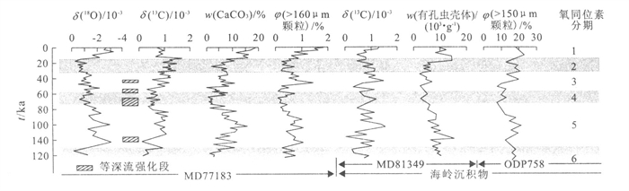
The analysis of measured data and sedimentary records shows that strong contour currents-occur in the Bay of Bengal. The sedimentary research into 3 piston cores from the middle and eastern Bengal deep-water fan indicates those thin-bedded muddy silts, with heavy oxidation colors and a few calcareous gravely-corroded shells but free of any graded bedding, are products of deposition of reworked materials by geostrophic bottom currents. The contour currents derived from the Arctic and Antarctic, essential constituents of the global thermohaline circulation, were repeatedly enhanced in the past 150 ka. This intensification of the currents, presenting a great impact on the environment changes in the province under study, may serve as a link to make a climatic enhancement of the tele-connection between the low-latitude and the pole regions. It is very unlikely that there is a close relation between the intensifications of the contour currents and the glacial cycles. The records of intensified contour currents can be observed in oxygen isotope stages 3, 4 and 5. The enhanced controlling mechanism remains to be further investigated.
The analysis of measured data and sedimentary records shows that strong contour currents-occur in the Bay of Bengal. The sedimentary research into 3 piston cores from the middle and eastern Bengal deep-water fan indicates those thin-bedded muddy silts, with heavy oxidation colors and a few calcareous gravely-corroded shells but free of any graded bedding, are products of deposition of reworked materials by geostrophic bottom currents. The contour currents derived from the Arctic and Antarctic, essential constituents of the global thermohaline circulation, were repeatedly enhanced in the past 150 ka. This intensification of the currents, presenting a great impact on the environment changes in the province under study, may serve as a link to make a climatic enhancement of the tele-connection between the low-latitude and the pole regions. It is very unlikely that there is a close relation between the intensifications of the contour currents and the glacial cycles. The records of intensified contour currents can be observed in oxygen isotope stages 3, 4 and 5. The enhanced controlling mechanism remains to be further investigated.


2002, 27(5): 576-583.
Abstract:
Potassium feldspar wastes from Shaxian County, Fujian Province were used as raw materials to prepare mineral polymer in this study. The waste particles ranging from 0.4 to 1 000 μm in size, averaging to 45 μm, were mixed with calcined kaolin. With liquid sodium silicate as structural template, and sodium hydroxide solution as activator, the mineral polymers were prepared. The optimal technical parameters were determined by the orthogonal experiments, as shown below (by weight) : the proportion of kaolin in the solid materials was 1/4, the ratio of NaOH solution (10 mol/L) to sodium silicate (m =3.3) in the liquid was 3/7, the ratio of the solid to liquid was 4, at 60 ℃ and for 72 h. Compressive strengths of the mineral polymer samples were tested up to 19.4-24.9 MPa after 7-28 d's solidification, the acid and alkaline resistances well satisfied the China National Specifications for analogues of structural construction materials. As shown in the experiments, the kaolin proportion in the solid materials was kept around 20%, but the compressive strengths of the mineral polymers were enhanced with increasing both the proportion of sodium silicate in the liquid and the ratio of solid to liquid, resulting in the paradoxical change of the compressive strengths with the prolonging of the solidifying time. The formation process of mineral polymers can be divided into four stages, i.e., dissolution of aluminium and silicon from particles of kaolin and the waste solid materials and its complex in the liquid, diffusion from the particle surface into interstitial space, concentrating and polymerization of the components by geochemical reactions to form interstitial aluminosilicate gel, and dehydration of extra water and solidification of the gel phase. The matrix phase so formed in mineral polymer, similar to zeolite in chemical composition, is possibly an analogue of opal in microtexture, and shows a three dimension network in physical framework acting as a structural foundation of the mineral polymers with excellent mechanical properties.
Potassium feldspar wastes from Shaxian County, Fujian Province were used as raw materials to prepare mineral polymer in this study. The waste particles ranging from 0.4 to 1 000 μm in size, averaging to 45 μm, were mixed with calcined kaolin. With liquid sodium silicate as structural template, and sodium hydroxide solution as activator, the mineral polymers were prepared. The optimal technical parameters were determined by the orthogonal experiments, as shown below (by weight) : the proportion of kaolin in the solid materials was 1/4, the ratio of NaOH solution (10 mol/L) to sodium silicate (m =3.3) in the liquid was 3/7, the ratio of the solid to liquid was 4, at 60 ℃ and for 72 h. Compressive strengths of the mineral polymer samples were tested up to 19.4-24.9 MPa after 7-28 d's solidification, the acid and alkaline resistances well satisfied the China National Specifications for analogues of structural construction materials. As shown in the experiments, the kaolin proportion in the solid materials was kept around 20%, but the compressive strengths of the mineral polymers were enhanced with increasing both the proportion of sodium silicate in the liquid and the ratio of solid to liquid, resulting in the paradoxical change of the compressive strengths with the prolonging of the solidifying time. The formation process of mineral polymers can be divided into four stages, i.e., dissolution of aluminium and silicon from particles of kaolin and the waste solid materials and its complex in the liquid, diffusion from the particle surface into interstitial space, concentrating and polymerization of the components by geochemical reactions to form interstitial aluminosilicate gel, and dehydration of extra water and solidification of the gel phase. The matrix phase so formed in mineral polymer, similar to zeolite in chemical composition, is possibly an analogue of opal in microtexture, and shows a three dimension network in physical framework acting as a structural foundation of the mineral polymers with excellent mechanical properties.


2002, 27(5): 584-591.
Abstract:
Chromate ions have high affinity for soluble hydroxy-Fe species and for Fe-oxyhydroxide precipitates. The hydrolysis of Fe (Ⅲ) and the growth of initially precipitated Fe (Ⅲ) phases is, in turn, strongly affected by montmorillonite. In this paper, the adsorption of Cr (Ⅵ) in the system hydroxy-Fe-montmorillonite was studied. Four series of batch experiments were conducted by mixing montmorillonite, hydroxy-Fe and chromate in the following order: (1) Montmorillonite+hydroxy-Fe before addition of chromate; (2) Hydroxy Fe+chromate before addition of montmorillonite; (3) Montmorillonite+chromate before addition of hydroxy-Fe; (4) Hydroxy-Fe+chromate. For each series, the effects of pH, ionic strength, temperature, initial Cr concentration and adsorption duration on the overall uptake of Cr in the system hydroxy-Fe-montmorillonite were studied.Resultsshow that the uptake of Cr increases with the increase in ionic strength and decreases with the increases in temperature, initial Cr concentration and adsorption duration. Optimum pH values exist for Series 2, 3 and 4, but not for Series 1. These effects occur, to different extents, in the four series. On all experimental conditions, the hydroxy-Fe-montmorillonite system displayed very strong affinity for Cr with Series 3 containing the highest Cr adsorption capacity and Series 1 the lowest. The authors attribute this to the difference in mixing order adopted, resulting in more hydroxy-Fe (the main adsorbent for Cr) being adsorbed onto montmorillonite for Series 1 before the hydroxy-Fe is able to adsorb Cr, that is the case for Series 2 and 3. Discussions and explanations have been given to these experimental phenomena.
Chromate ions have high affinity for soluble hydroxy-Fe species and for Fe-oxyhydroxide precipitates. The hydrolysis of Fe (Ⅲ) and the growth of initially precipitated Fe (Ⅲ) phases is, in turn, strongly affected by montmorillonite. In this paper, the adsorption of Cr (Ⅵ) in the system hydroxy-Fe-montmorillonite was studied. Four series of batch experiments were conducted by mixing montmorillonite, hydroxy-Fe and chromate in the following order: (1) Montmorillonite+hydroxy-Fe before addition of chromate; (2) Hydroxy Fe+chromate before addition of montmorillonite; (3) Montmorillonite+chromate before addition of hydroxy-Fe; (4) Hydroxy-Fe+chromate. For each series, the effects of pH, ionic strength, temperature, initial Cr concentration and adsorption duration on the overall uptake of Cr in the system hydroxy-Fe-montmorillonite were studied.Resultsshow that the uptake of Cr increases with the increase in ionic strength and decreases with the increases in temperature, initial Cr concentration and adsorption duration. Optimum pH values exist for Series 2, 3 and 4, but not for Series 1. These effects occur, to different extents, in the four series. On all experimental conditions, the hydroxy-Fe-montmorillonite system displayed very strong affinity for Cr with Series 3 containing the highest Cr adsorption capacity and Series 1 the lowest. The authors attribute this to the difference in mixing order adopted, resulting in more hydroxy-Fe (the main adsorbent for Cr) being adsorbed onto montmorillonite for Series 1 before the hydroxy-Fe is able to adsorb Cr, that is the case for Series 2 and 3. Discussions and explanations have been given to these experimental phenomena.


2002, 27(5): 592-598.
Abstract:
Over the past ten years, great progress has been made in the exploration of subtle traps both inside and outside China, whose key technology is the high-resolution 3D seismic detection and the high-resolution 3D seismic detection-based sequence stratigraphic research. The combination of the two technologies has been termed by the petroleum and gas industry as the "authoritative technology". The lacustrine fault basin is the most important for the generation of oil and gas in the east of China. In particular, the structure, paleoclimate and the paleogeographical setting play a dominant role in lacustrine basin types and evolution. In addition, the sequence architectural model established to forecast the oil and gas resources should reflect the sedimentary structural evolution features of the lacustrine fault basin. In the mature exploration areas, more important discoveries in the subtle traps may be made in such aspects as the re-establishment of the isochronous sequence statigraphic framework, the compilation of the systems tract exploration map, the clarification of the distribution pattern of the sedimentary system, the emphasis on the fault controlled slope break and low stand systems tract fans, and the location of the subtle traps with high resolution geophysical technology.
Over the past ten years, great progress has been made in the exploration of subtle traps both inside and outside China, whose key technology is the high-resolution 3D seismic detection and the high-resolution 3D seismic detection-based sequence stratigraphic research. The combination of the two technologies has been termed by the petroleum and gas industry as the "authoritative technology". The lacustrine fault basin is the most important for the generation of oil and gas in the east of China. In particular, the structure, paleoclimate and the paleogeographical setting play a dominant role in lacustrine basin types and evolution. In addition, the sequence architectural model established to forecast the oil and gas resources should reflect the sedimentary structural evolution features of the lacustrine fault basin. In the mature exploration areas, more important discoveries in the subtle traps may be made in such aspects as the re-establishment of the isochronous sequence statigraphic framework, the compilation of the systems tract exploration map, the clarification of the distribution pattern of the sedimentary system, the emphasis on the fault controlled slope break and low stand systems tract fans, and the location of the subtle traps with high resolution geophysical technology.


2002, 27(5): 599-604.
Abstract:
Qinling is an intracontinental polycyclic complex collision orogen, and also is one of the most important polymetallic ore-forming belts. Qinling had undergone four tectonic stages and many times tectonic system changes and resulted in the multi-period structure-thermal events and ore-forming processes since Archeozoic, the ore-forming course underwent multicyclic tectonometallogenic evolution also. These created the conditions of the metal elements enrichment and to ore content in large scale. The six regional metallogenic systems have been recognized from early to late in Qinling orogen, in which the Meso-Late Proterozoic metallogenic system related to seafloor volcanic and island arc magmatic activity, Early Paleozoic metallogenic system related to seafloor volcanic hydrothermal fluid, the Hercynian period metallogenic system related to hydrothermal fluid and magmatic processes and Mesozoic metallogenic system related to tectonic-magma activity in intracontinental orogenic system, etc, have more contribution. The superposition of different metallogenic systems is the precondition to most large and super-large type deposits.
Qinling is an intracontinental polycyclic complex collision orogen, and also is one of the most important polymetallic ore-forming belts. Qinling had undergone four tectonic stages and many times tectonic system changes and resulted in the multi-period structure-thermal events and ore-forming processes since Archeozoic, the ore-forming course underwent multicyclic tectonometallogenic evolution also. These created the conditions of the metal elements enrichment and to ore content in large scale. The six regional metallogenic systems have been recognized from early to late in Qinling orogen, in which the Meso-Late Proterozoic metallogenic system related to seafloor volcanic and island arc magmatic activity, Early Paleozoic metallogenic system related to seafloor volcanic hydrothermal fluid, the Hercynian period metallogenic system related to hydrothermal fluid and magmatic processes and Mesozoic metallogenic system related to tectonic-magma activity in intracontinental orogenic system, etc, have more contribution. The superposition of different metallogenic systems is the precondition to most large and super-large type deposits.
2002, 27(5): 605-609.
Abstract:
Digital State Land and Resources", a grand project in the 21st century, is a response to the state strategic plans called "Digital Earth" and "Digital China", respectively. Its core is the construction of distributed point source spatial database and attribute database. The important problems of technology are the modeling of the subject database, the "multi S" integration, the three level network structure, the computer aided design of geological maps, the information standardization system, the entry of numerous data to the database and the information security. This grand project needs a set of logical and perfect solutions. Problem shooting countermeasures and procedures are suggested that have incorporated latest achievements in the construction of land and resources information system in the world and those in the development of geoinformatics, and followed the overall system analysis and system design in line with the special pattern of the Chinese land and resources exploration and management.
Digital State Land and Resources", a grand project in the 21st century, is a response to the state strategic plans called "Digital Earth" and "Digital China", respectively. Its core is the construction of distributed point source spatial database and attribute database. The important problems of technology are the modeling of the subject database, the "multi S" integration, the three level network structure, the computer aided design of geological maps, the information standardization system, the entry of numerous data to the database and the information security. This grand project needs a set of logical and perfect solutions. Problem shooting countermeasures and procedures are suggested that have incorporated latest achievements in the construction of land and resources information system in the world and those in the development of geoinformatics, and followed the overall system analysis and system design in line with the special pattern of the Chinese land and resources exploration and management.
2002, 27(5): 610-615.
Abstract:
Accumulation at late stages has been confirmed to be an important characteristics of most large and medium sized oil/gas reservoirs in China. From the viewpoint of late accumulation, the existence of active source rocks and reservoir rocks with relatively high porosity and permeability in the deep part of the basin, and favorite pressure distribution between reservoir rocks and seals were required for the accumulation of deep oil/gas reservoirs. In overpressured basins, source rocks that would have reached the metagenetic stage without retardation in normally pressured basins have been kept within the zones favorable for hydrocarbon generation and expulsion due to overpressure retardation, which provides good hydrocarbon sources for oil/gas accumulations in the deep intervals. The weak mechanical compaction due to low effective stress, and weak chemical diagenesis due to closed or semi closed fluid systems in overpressured conditions lead to the preservation of relatively high porosities and permeabilities for the deeply buried sandstones. However, because of the natural hydraulic fracturing of strata and cross formation migration of fluids including oil and gas, effective energy distribution between reservoir rocks and seals are required for the accumulation and preservation of deep oil and gas accumulation in overpressured conditions.
Accumulation at late stages has been confirmed to be an important characteristics of most large and medium sized oil/gas reservoirs in China. From the viewpoint of late accumulation, the existence of active source rocks and reservoir rocks with relatively high porosity and permeability in the deep part of the basin, and favorite pressure distribution between reservoir rocks and seals were required for the accumulation of deep oil/gas reservoirs. In overpressured basins, source rocks that would have reached the metagenetic stage without retardation in normally pressured basins have been kept within the zones favorable for hydrocarbon generation and expulsion due to overpressure retardation, which provides good hydrocarbon sources for oil/gas accumulations in the deep intervals. The weak mechanical compaction due to low effective stress, and weak chemical diagenesis due to closed or semi closed fluid systems in overpressured conditions lead to the preservation of relatively high porosities and permeabilities for the deeply buried sandstones. However, because of the natural hydraulic fracturing of strata and cross formation migration of fluids including oil and gas, effective energy distribution between reservoir rocks and seals are required for the accumulation and preservation of deep oil and gas accumulation in overpressured conditions.


2002, 27(5): 616-620.
Abstract:
High resolution data about trace organic contaminant concentrations in aquatic environment of Wuhan were obtained in this study, on the basis of detailed hydrogeological and groundwater contamination investigations. More than 30 organic contaminants have been detected, in which benzene hydrocarbons are the most widespread. The seriously contaminated groundwater comes from densely populated, industrial and commercial areas. Applying the DRA MIC model proposed by the authors as an improved version of the widely used DRA STIC model to the assessment of the vulnerability of groundwater to contamination in urban areas, the authors draw a GIS based vulnerability map of Wuhan city. Finally, the authors propose some suggestions about environmental protection and risk management for highly vulnerable regions in line with the assessment results thus made in this paper.
High resolution data about trace organic contaminant concentrations in aquatic environment of Wuhan were obtained in this study, on the basis of detailed hydrogeological and groundwater contamination investigations. More than 30 organic contaminants have been detected, in which benzene hydrocarbons are the most widespread. The seriously contaminated groundwater comes from densely populated, industrial and commercial areas. Applying the DRA MIC model proposed by the authors as an improved version of the widely used DRA STIC model to the assessment of the vulnerability of groundwater to contamination in urban areas, the authors draw a GIS based vulnerability map of Wuhan city. Finally, the authors propose some suggestions about environmental protection and risk management for highly vulnerable regions in line with the assessment results thus made in this paper.

2002, 27(5): 621-625.
Abstract:
The safety of the Zhaoshuling landslide, one of the most important landslides in the Three Gorges Reservoir, is directly related to that of Yanjiang Road which is located along the Changjiang River, and is also important to the land use of the Badong County, a new established county. This paper first describes the essential features of the Zhaoshuling landslide, and then presents the simulation of landslide stability using 3D finite element method for water stress coupling, and the forecasting of the landslide stability trend and permeability features after the Three Gorges Reservoir is in operation. The research shows that the change in the reservoir water is the major factor to affect the stability of the landslide. After the Three Gorges Reservoir is in operation, some parts of the landslide will turn instable. In this sense, this paper offers some principles and counter measures to prevent and treat the landslide.
The safety of the Zhaoshuling landslide, one of the most important landslides in the Three Gorges Reservoir, is directly related to that of Yanjiang Road which is located along the Changjiang River, and is also important to the land use of the Badong County, a new established county. This paper first describes the essential features of the Zhaoshuling landslide, and then presents the simulation of landslide stability using 3D finite element method for water stress coupling, and the forecasting of the landslide stability trend and permeability features after the Three Gorges Reservoir is in operation. The research shows that the change in the reservoir water is the major factor to affect the stability of the landslide. After the Three Gorges Reservoir is in operation, some parts of the landslide will turn instable. In this sense, this paper offers some principles and counter measures to prevent and treat the landslide.


2002, 27(5): 626-631.
Abstract:
The nitroglycerine dynamite for road building and mining invented 150 years ago by Nobel, a Sweden, after the invention of Chinese explosives, initiated the industrial revolution in its true sense that brought about high speed growth of social wealth. In 1923, a German invented WC Co cemented carbide, resulting in two major industries of hard alloy cutting tools and hard alloy rock drilling bits. As a consequence, the machine and excavating and mining industries grow rapidly. The cemented carbide is thus termed as the "industrial teeth". In particular, up to now, the modern rock drilling blasting technology has turned into a major means for the human being to obtain resources from the lithosphere and to expand the survival and development space to the underground. In particular, the rock drilling rods are the consumption tools with the smallest range of pressure conditions and the shortest service life in all the machine tools. This kind of rods, indispensable to the basic industry, is of high technology. The manufacture of long service life percussive rock drilling rods has already turned into an important engineering technology puzzle in the 21st century for the global excavation industry that requires highly efficient and low consumption drilling rods. The realization of this target needs the long term cooperation from many experts in rock drilling, blasting, rock fracturing, mining, materials, metallurgy, iron and steel, machine, physics, chemical industry, electronics, mathematics, mechanics and biology (bionics). The establishment of the Chinese modern rock drilling tools industry marked by new types of "cemented carbide drilling tools" and "long service life percussive rock drilling rods" is a new development point strategic to the new generation of "resources high tech export oriented" Chinese national industry.
The nitroglycerine dynamite for road building and mining invented 150 years ago by Nobel, a Sweden, after the invention of Chinese explosives, initiated the industrial revolution in its true sense that brought about high speed growth of social wealth. In 1923, a German invented WC Co cemented carbide, resulting in two major industries of hard alloy cutting tools and hard alloy rock drilling bits. As a consequence, the machine and excavating and mining industries grow rapidly. The cemented carbide is thus termed as the "industrial teeth". In particular, up to now, the modern rock drilling blasting technology has turned into a major means for the human being to obtain resources from the lithosphere and to expand the survival and development space to the underground. In particular, the rock drilling rods are the consumption tools with the smallest range of pressure conditions and the shortest service life in all the machine tools. This kind of rods, indispensable to the basic industry, is of high technology. The manufacture of long service life percussive rock drilling rods has already turned into an important engineering technology puzzle in the 21st century for the global excavation industry that requires highly efficient and low consumption drilling rods. The realization of this target needs the long term cooperation from many experts in rock drilling, blasting, rock fracturing, mining, materials, metallurgy, iron and steel, machine, physics, chemical industry, electronics, mathematics, mechanics and biology (bionics). The establishment of the Chinese modern rock drilling tools industry marked by new types of "cemented carbide drilling tools" and "long service life percussive rock drilling rods" is a new development point strategic to the new generation of "resources high tech export oriented" Chinese national industry.
2002, 27(5): 632-636.
Abstract:
Landslide is a dynamic process. The movement of landslide body is a complex dynamic process composed of sliding, rotational, and tensile movements. Either the traditional limit equilibrium calculation or finite element analysis cannot be used to describe the characteristics and process of landslide movements. The discontinuous deformation analysis (DDA), a new discrete numerical simulation method, incorporates both the massive dynamic theory and the numerical analysis, so as to make a static and dynamic calculation of the massive body. In this paper, the discontinuous deformation analysis is applied to the numerical simulation of the dynamic movement process of Xintan landslide in the Three Gorges reservoir. This simulation classifies the landslide profile as 504 units in terms of geology, topography, soil and rock body types and geological structural surface types. The simulation results show that the Xintan landslide started with the partial failure of the Jiangjiapo belt in the middle of the landslide, and then the upper part of the landslide was further trailed upward and the lower part of the landslide was further pushed downward. Both the displacement variation curves and the sliding speed variation curves of the representative massive units show that the deformation of the massive body system of the sliding slope is discontinuous in the sliding process, and that the movements of different masses are quite different in shape, reflecting well the whole dynamic process of the landslide and revealing the dynamic mechanism of the landslide.
Landslide is a dynamic process. The movement of landslide body is a complex dynamic process composed of sliding, rotational, and tensile movements. Either the traditional limit equilibrium calculation or finite element analysis cannot be used to describe the characteristics and process of landslide movements. The discontinuous deformation analysis (DDA), a new discrete numerical simulation method, incorporates both the massive dynamic theory and the numerical analysis, so as to make a static and dynamic calculation of the massive body. In this paper, the discontinuous deformation analysis is applied to the numerical simulation of the dynamic movement process of Xintan landslide in the Three Gorges reservoir. This simulation classifies the landslide profile as 504 units in terms of geology, topography, soil and rock body types and geological structural surface types. The simulation results show that the Xintan landslide started with the partial failure of the Jiangjiapo belt in the middle of the landslide, and then the upper part of the landslide was further trailed upward and the lower part of the landslide was further pushed downward. Both the displacement variation curves and the sliding speed variation curves of the representative massive units show that the deformation of the massive body system of the sliding slope is discontinuous in the sliding process, and that the movements of different masses are quite different in shape, reflecting well the whole dynamic process of the landslide and revealing the dynamic mechanism of the landslide.


2002, 27(5): 637-644.
Abstract:
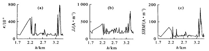
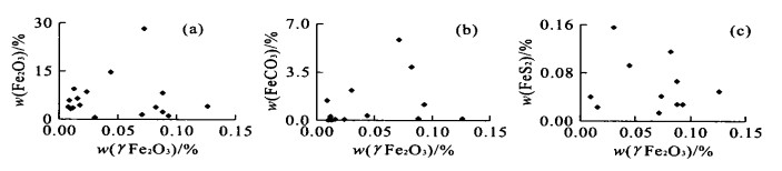
Magnetic measurements of rocks in an oil and gas bearing well located on the margin of an oil and gas field, southern Songliao basin, show that the rocks there are characterized by the conspicuous magnetic anomalous structure. The magnetic susceptibility anomalies (κ), for example, are classified as two categories: the high intensity (κ > 400×10-5) and the moderate intensity (κ : 100×10-5 - 150×10-5) on the low background magnetism. As shown in the interpretation of the logging references and the geochemical analysis, the strong magnetic anomaly is located mainly in the dry layer at the bottom of the sampling interstitial positions. Few samples are located in the oil and gas display layer in the shallow part of the field. The intermediate magnetic anomaly is located in the oil and gas display layer at the depth around 2 700 meters. The correlation between the magnetism and geochemical compositions shows a positive correlation between geochemical compositions C1, C2 and magnetic intensities parameters (i.e. susceptibility κ, saturation magnetization Js and saturation isothermal remnant magnetization SIRM), but a negative correlation between geochemical compositions C1, C2 and intrinsic coercivity in the rocks of the oil and gas bearing layers. However, these correlations are not found in dry layers. The analysis of the iron bearing mineral compositions indicates that the major iron bearing minerals in the rocks are magnetite, maghemite, hematite, pyrite and siderite. In particular, the maghemite distributes mainly in the oil and gas bearing layer with the intermediate magnetic intensity. But the magnetite with the iron contents of 12.5% distributes mainly in the dry layer at the bottom. The correlations in contents between maghemite and hematite and between pyrite and siderite indicate that the authigenous maghemite may have originated largely from the autochthonous hematite and pyrite. It can be inferred that the maghemite, whose magnetic intensity is weak inclined in the rocks of the oil and gas bearing layer, is a product of the hydrocarbon alteration, providing us with some new evidence for the complete space formation mechanism of the hydrocarbon micro percolation effect (or chimney effect).
Magnetic measurements of rocks in an oil and gas bearing well located on the margin of an oil and gas field, southern Songliao basin, show that the rocks there are characterized by the conspicuous magnetic anomalous structure. The magnetic susceptibility anomalies (κ), for example, are classified as two categories: the high intensity (κ > 400×10-5) and the moderate intensity (κ : 100×10-5 - 150×10-5) on the low background magnetism. As shown in the interpretation of the logging references and the geochemical analysis, the strong magnetic anomaly is located mainly in the dry layer at the bottom of the sampling interstitial positions. Few samples are located in the oil and gas display layer in the shallow part of the field. The intermediate magnetic anomaly is located in the oil and gas display layer at the depth around 2 700 meters. The correlation between the magnetism and geochemical compositions shows a positive correlation between geochemical compositions C1, C2 and magnetic intensities parameters (i.e. susceptibility κ, saturation magnetization Js and saturation isothermal remnant magnetization SIRM), but a negative correlation between geochemical compositions C1, C2 and intrinsic coercivity in the rocks of the oil and gas bearing layers. However, these correlations are not found in dry layers. The analysis of the iron bearing mineral compositions indicates that the major iron bearing minerals in the rocks are magnetite, maghemite, hematite, pyrite and siderite. In particular, the maghemite distributes mainly in the oil and gas bearing layer with the intermediate magnetic intensity. But the magnetite with the iron contents of 12.5% distributes mainly in the dry layer at the bottom. The correlations in contents between maghemite and hematite and between pyrite and siderite indicate that the authigenous maghemite may have originated largely from the autochthonous hematite and pyrite. It can be inferred that the maghemite, whose magnetic intensity is weak inclined in the rocks of the oil and gas bearing layer, is a product of the hydrocarbon alteration, providing us with some new evidence for the complete space formation mechanism of the hydrocarbon micro percolation effect (or chimney effect).


2002, 27(5): 645-650.
Abstract:
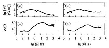
In 2001, an MT sounding profile was relocated from Yingxian, Shanxi Province to Shanghe, Shandong Province. The advanced MT data processing method and rapid release inversion (RRI) were employed to establish a 2D model of conductivity structure showing fully the features of conductivity structure of the lithosphere in North China. In terms of conductivity, the North China lithosphere is classified as eastern and western parts with the frontal fault in the Taihang mountain as the corresponding boundary line. The eastern part is characterized by the low resistance conductivity, and the western part is characterized by the high resistance conductivity. In the eastern part, the conductivity structure in the upper crust corresponds roughly to the uplift and depression tectonic structure of the North China rift system, with the maximum conductivity of the lithosphere reaching 3×10⁴ S, far greater than that of magma arc area in Andes and the lithosphere of the Tibet plateau where the volcanic activities are violent. Here, discontinuous highly conductive bodies, whose conductivity is about 0.1-0.8 S/m, are present in the crust of the contact zone. In the western part, the lithosphere of the Taihang and Hengshan mountains, composed of high resistance conductivity bodies, is characterized by the conductivity structure of a stable continental lithosphere. However, a group of westward inclined highly conductive layers, whose conductivity is 0.04-0.25 S/m, whose top layer is located at the depth of 20 km and whose bottom layer is located at the depth of around 40 km, were discovered under the Hengshan high resistance conductivity body
In 2001, an MT sounding profile was relocated from Yingxian, Shanxi Province to Shanghe, Shandong Province. The advanced MT data processing method and rapid release inversion (RRI) were employed to establish a 2D model of conductivity structure showing fully the features of conductivity structure of the lithosphere in North China. In terms of conductivity, the North China lithosphere is classified as eastern and western parts with the frontal fault in the Taihang mountain as the corresponding boundary line. The eastern part is characterized by the low resistance conductivity, and the western part is characterized by the high resistance conductivity. In the eastern part, the conductivity structure in the upper crust corresponds roughly to the uplift and depression tectonic structure of the North China rift system, with the maximum conductivity of the lithosphere reaching 3×10⁴ S, far greater than that of magma arc area in Andes and the lithosphere of the Tibet plateau where the volcanic activities are violent. Here, discontinuous highly conductive bodies, whose conductivity is about 0.1-0.8 S/m, are present in the crust of the contact zone. In the western part, the lithosphere of the Taihang and Hengshan mountains, composed of high resistance conductivity bodies, is characterized by the conductivity structure of a stable continental lithosphere. However, a group of westward inclined highly conductive layers, whose conductivity is 0.04-0.25 S/m, whose top layer is located at the depth of 20 km and whose bottom layer is located at the depth of around 40 km, were discovered under the Hengshan high resistance conductivity body


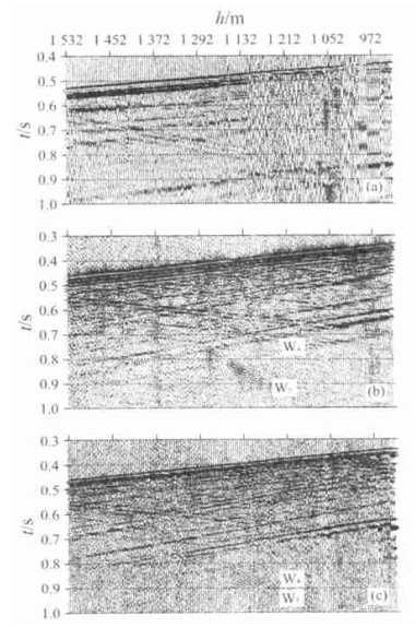
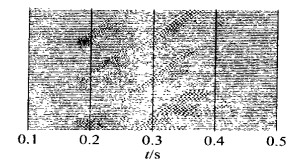
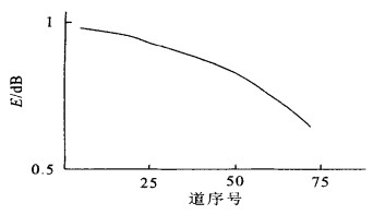
2002, 27(5): 651-658.
Abstract:
The authors worked in 1997 on the high resolution VSP in the hydraulic fractured sandstone oil well. The authors observed not only the normal compressional waves and converted waves, but also several strange slow speed waves from the oil producing layer. Since the nature of this slow speed wave arrival was not distinct, these slow speed waves were named as W1, W2 and W3 respectively (where W stands for wave), according to their apparent velocities ranging form high to low. Five reflected waves which are reflected compressional wave, reflected converted wave, W1, W2 and W3 were observed at the depth of 1 210 m in the fracture dominating direction in Shun 5 Well. W2 and W3 did not occur in the fracture non dominating direction. Four reflected waves which are reflected compressional wave, reflected converted wave and two slow speed waves named as W4 and W5 for the distinction from the slow speed waves in Shun 5 Well, were observed. The data on well boring, well logging, surface seism and inter well borehole seism are employed in this research to make a detailed analysis of the slow speed waves thus observed. The analytical results show that these slow waves are not diffracted waves from heterogeneous medium and that the reflected waves from the lateral interface, channel waves, tube waves and stoneley waves are also not in agreement with the dynamic feature of the Biot slow speed compressonal waves. Existing wave theory does not interpret this kind of slow speed wave arrivals, indicating that some laws of elastic wave propagation in the inner medium of the earth are still not recognized by the scientists concerned.
The authors worked in 1997 on the high resolution VSP in the hydraulic fractured sandstone oil well. The authors observed not only the normal compressional waves and converted waves, but also several strange slow speed waves from the oil producing layer. Since the nature of this slow speed wave arrival was not distinct, these slow speed waves were named as W1, W2 and W3 respectively (where W stands for wave), according to their apparent velocities ranging form high to low. Five reflected waves which are reflected compressional wave, reflected converted wave, W1, W2 and W3 were observed at the depth of 1 210 m in the fracture dominating direction in Shun 5 Well. W2 and W3 did not occur in the fracture non dominating direction. Four reflected waves which are reflected compressional wave, reflected converted wave and two slow speed waves named as W4 and W5 for the distinction from the slow speed waves in Shun 5 Well, were observed. The data on well boring, well logging, surface seism and inter well borehole seism are employed in this research to make a detailed analysis of the slow speed waves thus observed. The analytical results show that these slow waves are not diffracted waves from heterogeneous medium and that the reflected waves from the lateral interface, channel waves, tube waves and stoneley waves are also not in agreement with the dynamic feature of the Biot slow speed compressonal waves. Existing wave theory does not interpret this kind of slow speed wave arrivals, indicating that some laws of elastic wave propagation in the inner medium of the earth are still not recognized by the scientists concerned.