


2003 Vol. 28, No. 4
Display Method:
2003, 28(4): 361-369.
 PDF 622KB
Abstract:
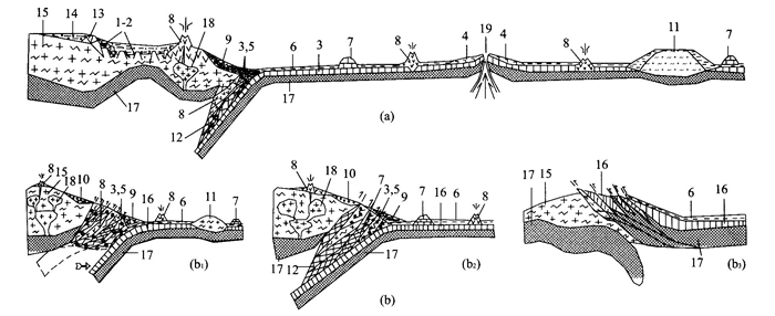
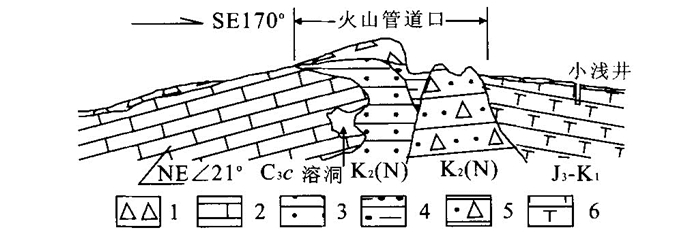
International Stratigraphic Guide pointed out that stratigraphy should be defined as the description of all rock bodies constituting the earth crust. Hence, all kinds of rocks, including sedimentary, igneous, metamorphic, solidified and unsolidified rocks, should be considered as research contents of stratigraphy. While traditional stratigraphy mainly studies strata by gravitative deposit, though including some parts of bedded volcanic rocks such as lava, pyroclastic rocks and volcanic ashes. Smith strata are regarded as the strata deposited in gravity, including related strata such as depositional metamorphic and volcanic rocks in this paper. Whereas in modern stratigraphy, the mechanic mechanism of strata origination includes not only gravity, but also thermal (ophiolite), mechanic and tectonic forces (orogenic mixtite and tectonite). In these above-mentioned non-gravitative conditions, the strata, formed with their own mechanisms but not with the overlap rules of Smith stratigraphy, are called non-Smith strata here. In the orogenic belt mélange regions, formations of non-Smith strata could be classified into subduct-scrape-match, subduct-return-match and subduct-overthrust types.
International Stratigraphic Guide pointed out that stratigraphy should be defined as the description of all rock bodies constituting the earth crust. Hence, all kinds of rocks, including sedimentary, igneous, metamorphic, solidified and unsolidified rocks, should be considered as research contents of stratigraphy. While traditional stratigraphy mainly studies strata by gravitative deposit, though including some parts of bedded volcanic rocks such as lava, pyroclastic rocks and volcanic ashes. Smith strata are regarded as the strata deposited in gravity, including related strata such as depositional metamorphic and volcanic rocks in this paper. Whereas in modern stratigraphy, the mechanic mechanism of strata origination includes not only gravity, but also thermal (ophiolite), mechanic and tectonic forces (orogenic mixtite and tectonite). In these above-mentioned non-gravitative conditions, the strata, formed with their own mechanisms but not with the overlap rules of Smith stratigraphy, are called non-Smith strata here. In the orogenic belt mélange regions, formations of non-Smith strata could be classified into subduct-scrape-match, subduct-return-match and subduct-overthrust types.
2003, 28(4): 370-376.
Abstract:
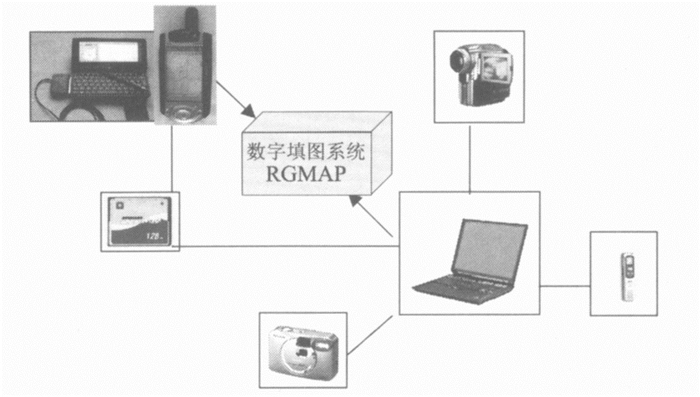
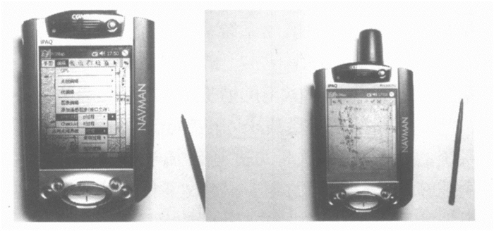
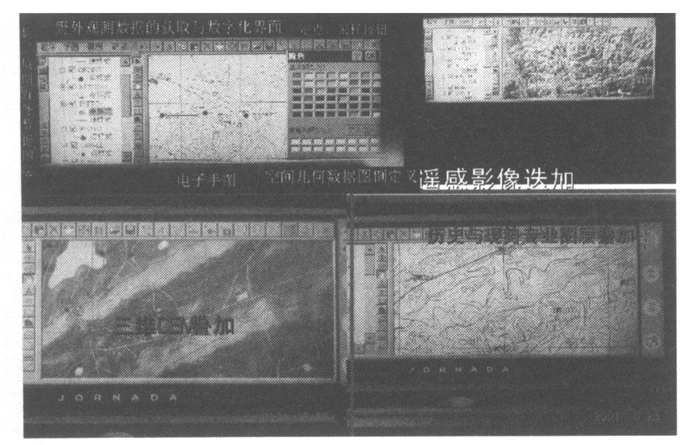
Digital geological mapping obtains regional geological survey data in the field and re-shows its production in digital regularity. At present, achievements have been made in the data collecting, storage, managing, describing, analyzing and reconstructing of the geological body information with space distribution in digital mapping system. With the assistance of computer, we can synthetically analyze multi-source geological data of geology, geography, geophysics, geochemistry and remote sensing from field geological observations. We have also achieved basic GIS function (GPS orientation, routing collection, sketch) under the Windows CE platform in the laptop computer and attained the conformity between remote-sensing and digital mapping system.
Digital geological mapping obtains regional geological survey data in the field and re-shows its production in digital regularity. At present, achievements have been made in the data collecting, storage, managing, describing, analyzing and reconstructing of the geological body information with space distribution in digital mapping system. With the assistance of computer, we can synthetically analyze multi-source geological data of geology, geography, geophysics, geochemistry and remote sensing from field geological observations. We have also achieved basic GIS function (GPS orientation, routing collection, sketch) under the Windows CE platform in the laptop computer and attained the conformity between remote-sensing and digital mapping system.
2003, 28(4): 377-383.
Abstract:
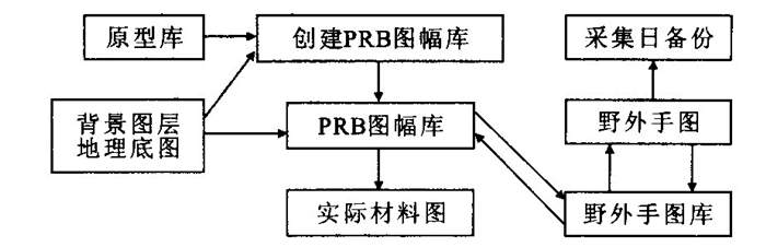
To deal with the problems and present situation of field data capture by computer in geological mapping in 20 years, this paper has created PRB digital mapping techniques to standardize the digital mapping process and discussed PRB mapping technique-method system, including PRB digital mapping techniques, the model of PRB data and the related process, combinational regulations of PRB process, common mechanism and basic procedure of PRB process, data processing and dictionary of PRB, three-class PRB system, data flow stack and quantitative evaluation of PRB data. PRB digital techniques, based on establishing the expression of spatial data in mapping, complying with regulations of traditional mapping, and describing the spatial relationships among different kinds of geological information, will not only meet needs of computer operation, but also ensure geologists to collect geological observational data comprehensively and accurately. Meanwhile, they also satisfy the thoughts of geologists.
To deal with the problems and present situation of field data capture by computer in geological mapping in 20 years, this paper has created PRB digital mapping techniques to standardize the digital mapping process and discussed PRB mapping technique-method system, including PRB digital mapping techniques, the model of PRB data and the related process, combinational regulations of PRB process, common mechanism and basic procedure of PRB process, data processing and dictionary of PRB, three-class PRB system, data flow stack and quantitative evaluation of PRB data. PRB digital techniques, based on establishing the expression of spatial data in mapping, complying with regulations of traditional mapping, and describing the spatial relationships among different kinds of geological information, will not only meet needs of computer operation, but also ensure geologists to collect geological observational data comprehensively and accurately. Meanwhile, they also satisfy the thoughts of geologists.


2003, 28(4): 385-388.
Abstract:
Prophase data preparation for PRB digital geological mapping includes preparing softwave and hardware, numerical value of relief map, former data collecting and indoor documentation, superimposing and merging of multi-element data and the PRB dictionary editing. PRB dictionary consists of structural dictionary, filling dictionary and describing dictionary. The first two dictionaries are 1 to 1.5 level that can be directly referred to, while the other one is the 2 level dictionary which should be referred twice. The documents of different dictionaries are all text documents and the suffix of documents is DIC.
Prophase data preparation for PRB digital geological mapping includes preparing softwave and hardware, numerical value of relief map, former data collecting and indoor documentation, superimposing and merging of multi-element data and the PRB dictionary editing. PRB dictionary consists of structural dictionary, filling dictionary and describing dictionary. The first two dictionaries are 1 to 1.5 level that can be directly referred to, while the other one is the 2 level dictionary which should be referred twice. The documents of different dictionaries are all text documents and the suffix of documents is DIC.

2003, 28(4): 389-394.
Abstract:
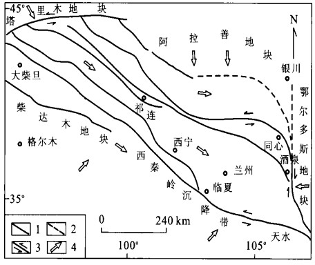
Quaternary structures and those multipleage stress changes reveal that the uplifting in southeastern Qilian Mountains results from the long-distance effect of the Indian plate compression and multiplex uplift mechanism on the adjacent massifs, producing the compression-uplifting, extension-uplifting and sinistral strike-slip uplifting in the area. The analysis of the stress and marker structures indicates that the uplift dynamic mechanism changes have occurred since Early Pleistocene epoch. The early Early Pleistocene is mainly NE-SW direction compression, the Middle Pleistocene to Early Holocene, mainly NE-SW and approaching E-W direction extension, while the Late Holocene is mainly NW-SE sinistral strike-slip. The stream valley downcutting rate since 1.41 Ma is estimated according to relative date of terrace from Huangshui River. The average rate from 1.41 Ma to 36.4 ka is slower, 0.11 mm/a, from 36.4 ka to the present, it is 1.54 mm/a and from 10.5 ka to 3 ka is 2.27-2.80 mm/a, the most rapid. It is shown that the tectonic uplifting in the area tends to be more and more intense since 1.41 Ma.
Quaternary structures and those multipleage stress changes reveal that the uplifting in southeastern Qilian Mountains results from the long-distance effect of the Indian plate compression and multiplex uplift mechanism on the adjacent massifs, producing the compression-uplifting, extension-uplifting and sinistral strike-slip uplifting in the area. The analysis of the stress and marker structures indicates that the uplift dynamic mechanism changes have occurred since Early Pleistocene epoch. The early Early Pleistocene is mainly NE-SW direction compression, the Middle Pleistocene to Early Holocene, mainly NE-SW and approaching E-W direction extension, while the Late Holocene is mainly NW-SE sinistral strike-slip. The stream valley downcutting rate since 1.41 Ma is estimated according to relative date of terrace from Huangshui River. The average rate from 1.41 Ma to 36.4 ka is slower, 0.11 mm/a, from 36.4 ka to the present, it is 1.54 mm/a and from 10.5 ka to 3 ka is 2.27-2.80 mm/a, the most rapid. It is shown that the tectonic uplifting in the area tends to be more and more intense since 1.41 Ma.


2003, 28(4): 395-400.
Abstract:
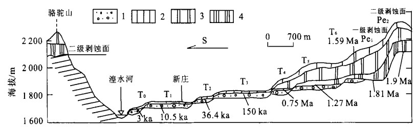
The typical stratified landforms in the southeastern margin of the Qilian Mountains have been recognized and studied in detail on the basis of digital elevation model, field survey and tectonic- geomorphologic section as well as the indoor study with the support of the operation system of regional digital geological survey and field mapping (RGMAP). There are two stages of planation surfaces (PI3 000 m, PII4 000 m), eleven stages of pediments (Pe1-11) and seven terraces (T0-T6) of the Huangshui River. Five terraces are developed in the Yellow River from the Yanguoxia to Bapanxia. Before the Yellow River mainstream passed through the Yanguoxia about 0.15 Ma, the Huangshui River used to be its upper reach. Combined with field survey and analyses indoors, every stages of stratified landforms (planation surfaces, pediments and terraces) are recognized, showing detailed features of distribution, sedimentary and formation ages and relation with neo-tectonic movements. This demonstrates that development of typical stratified landforms resulted from phased uplift of the Qinghai-Xizang plateau in Late Cenozoic.
The typical stratified landforms in the southeastern margin of the Qilian Mountains have been recognized and studied in detail on the basis of digital elevation model, field survey and tectonic- geomorphologic section as well as the indoor study with the support of the operation system of regional digital geological survey and field mapping (RGMAP). There are two stages of planation surfaces (PI3 000 m, PII4 000 m), eleven stages of pediments (Pe1-11) and seven terraces (T0-T6) of the Huangshui River. Five terraces are developed in the Yellow River from the Yanguoxia to Bapanxia. Before the Yellow River mainstream passed through the Yanguoxia about 0.15 Ma, the Huangshui River used to be its upper reach. Combined with field survey and analyses indoors, every stages of stratified landforms (planation surfaces, pediments and terraces) are recognized, showing detailed features of distribution, sedimentary and formation ages and relation with neo-tectonic movements. This demonstrates that development of typical stratified landforms resulted from phased uplift of the Qinghai-Xizang plateau in Late Cenozoic.


2003, 28(4): 401-406.
Abstract:
The Tertiary Xining Group largely bassets in Minhe County, Qinghai Province. The paper describes the spores and pollen grains collected from the Xining Group section in Shanglujiabao, Minhe County, Qinghai Province. The spore-pollen assemblage is identified to be Nitrariadites-Ephedripites-Chenopodipollis. The spore-pollen assemblage characters and the correlation with other related assemblages of China show that this assemblage may be of Late Eocene, and at that time this area could be very dry and torrid, and could have been covered with grassland compound with jungles.
The Tertiary Xining Group largely bassets in Minhe County, Qinghai Province. The paper describes the spores and pollen grains collected from the Xining Group section in Shanglujiabao, Minhe County, Qinghai Province. The spore-pollen assemblage is identified to be Nitrariadites-Ephedripites-Chenopodipollis. The spore-pollen assemblage characters and the correlation with other related assemblages of China show that this assemblage may be of Late Eocene, and at that time this area could be very dry and torrid, and could have been covered with grassland compound with jungles.


2003, 28(4): 407-413.
Abstract:
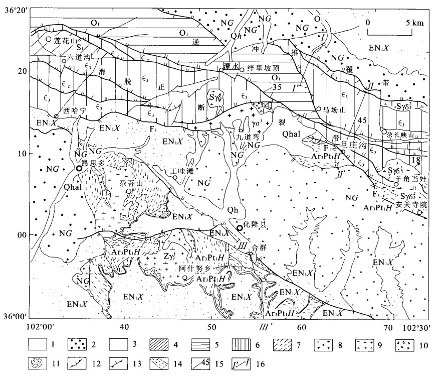
This paper studies the metamorphic core complex in Lajishan-Hualong area, middle Qilian. Its core consists of Archeozoic and Proterozoic Hualong Group metamorphic complexes undergoing ductile deformation, with its median layers, Middle-Upper Cambrian and mass of magmatic rocks undergoing plastic deformation of low-pressure metamorphism, and overlayers, Lower Cretaceous experiencing minor brittle deformation without metamorphism. The composition and texture of the metamorphic core complex show features of symmetrical extension and uplifting and a rapid uplifting period within 23 to 32 Ma and displacement quantity of normal denudational faults about 25-27 kilometres. The mineral pair calculation measures its extensional metamorphic temperature about 625-630 ℃, the metamorphic depth about 20 km and the metamorphic pressure about 0.63 GPa, which shows that it should belong to a regional thermal current metamorphism of low-pressure type. In the light of long run thermal crustal, thermal mantle, thick crustal evolution and tectonics upwelling of the Qinghai-Tibet plateau, the Lajishan-Hualong metamorphic core complex can be considered as a typical example of crust extension caused by thermal upwelling of mantle. The Lajishan-Hualong area can, therefore, become a window to look into the structure and tectonic upwelling of the Qinghai-Tibet plateau lithosphere.
This paper studies the metamorphic core complex in Lajishan-Hualong area, middle Qilian. Its core consists of Archeozoic and Proterozoic Hualong Group metamorphic complexes undergoing ductile deformation, with its median layers, Middle-Upper Cambrian and mass of magmatic rocks undergoing plastic deformation of low-pressure metamorphism, and overlayers, Lower Cretaceous experiencing minor brittle deformation without metamorphism. The composition and texture of the metamorphic core complex show features of symmetrical extension and uplifting and a rapid uplifting period within 23 to 32 Ma and displacement quantity of normal denudational faults about 25-27 kilometres. The mineral pair calculation measures its extensional metamorphic temperature about 625-630 ℃, the metamorphic depth about 20 km and the metamorphic pressure about 0.63 GPa, which shows that it should belong to a regional thermal current metamorphism of low-pressure type. In the light of long run thermal crustal, thermal mantle, thick crustal evolution and tectonics upwelling of the Qinghai-Tibet plateau, the Lajishan-Hualong metamorphic core complex can be considered as a typical example of crust extension caused by thermal upwelling of mantle. The Lajishan-Hualong area can, therefore, become a window to look into the structure and tectonic upwelling of the Qinghai-Tibet plateau lithosphere.


2003, 28(4): 414-418.
Abstract:
The authors provide a brief introduction on the Lower Triassic conodont zonation at West Pingdingshan Section, Chaohu, Anhui Province, China. Rich conodont fossils have been extracted from 172 productive samples in 286 analyzed samples, from the Lower Triassic Yinkeng, Helongshan, and the lower part of Nanlinghu Formation exposed at the section of 112.8 m thick. The extracted 2 187 conodont elements include 51 stratigraphically significant species referable to 11 genera: Hindeodus, Isarcicella(?), Neogondolella, Neospathodus, Platyvillosus, Cratognathodus, Parachirognathus, Pachycladina, Ellisonia, Aduncodina and Cornudina. Nine conodont zones are recognized in ascending order as follows: (1)Hindeodus typicalis-Neogondolella planataZone; (2)Neogondolella krystyni Zone; (3)Neospathodus kummeli Zone; (4)Neospathodus dieneri Zone; (5)Neospathodusn. sp. C-Neospathodusn. sp. D Zone; (6)Neospathodus waageni Zone; (7)Neospathodusn. sp. M Zone; (8)Neospathodus eotriangularis Zone; (9)Neospathodus abruptus-Neospathodus homeri Zone. Zones (2), (3), (5), (7) and (8) are first established and also Neospathodus waageniis reported for the first time from the Yinkeng Formation. Associated with conodonts also occur macrofossils such as ammonoids and bivalves, which confirm the conodont biochronostratigraphy to a certain degree.
The authors provide a brief introduction on the Lower Triassic conodont zonation at West Pingdingshan Section, Chaohu, Anhui Province, China. Rich conodont fossils have been extracted from 172 productive samples in 286 analyzed samples, from the Lower Triassic Yinkeng, Helongshan, and the lower part of Nanlinghu Formation exposed at the section of 112.8 m thick. The extracted 2 187 conodont elements include 51 stratigraphically significant species referable to 11 genera: Hindeodus, Isarcicella(?), Neogondolella, Neospathodus, Platyvillosus, Cratognathodus, Parachirognathus, Pachycladina, Ellisonia, Aduncodina and Cornudina. Nine conodont zones are recognized in ascending order as follows: (1)Hindeodus typicalis-Neogondolella planataZone; (2)Neogondolella krystyni Zone; (3)Neospathodus kummeli Zone; (4)Neospathodus dieneri Zone; (5)Neospathodusn. sp. C-Neospathodusn. sp. D Zone; (6)Neospathodus waageni Zone; (7)Neospathodusn. sp. M Zone; (8)Neospathodus eotriangularis Zone; (9)Neospathodus abruptus-Neospathodus homeri Zone. Zones (2), (3), (5), (7) and (8) are first established and also Neospathodus waageniis reported for the first time from the Yinkeng Formation. Associated with conodonts also occur macrofossils such as ammonoids and bivalves, which confirm the conodont biochronostratigraphy to a certain degree.
2003, 28(4): 419-424.
Abstract:
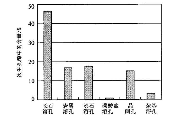
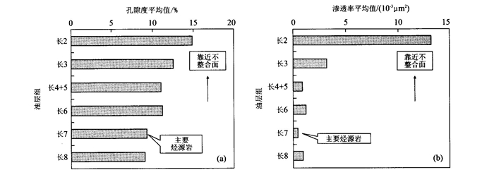
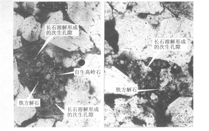
Secondary porosity is the most important reservoir space in the sandstone. The authors present an example of leaching by meteoric water in the Yanchang Formation sandstone of Triassic of Ordos basin. The interpretation is based on the information of detailed research of thin sections and a lot of statistical data. Yanchang Formation sandstone lies beneath the unconformity at the base of the Jurassic section. Subsequent detailed petrographic study has confirmed that the potassium depletion has brought about potassium feldspar dissolution, resulting in precipitation of kaolinite and creation of secondary porosity. The evidence strongly suggests the subaerial exposure of the Yanchang Formation sandstone in Early Jurassic and consequent freshwater leaching of the Yanchang Formation sandstone and generation of the secondary porosity. So secondary porosity of Yanchang Formation sandstone is not formed by the dissolution of organic acid during the time of burying diagenesis. The prediction model of reservoir quality should be modified by means of the new mechanisms of generation of secondary porosity.
Secondary porosity is the most important reservoir space in the sandstone. The authors present an example of leaching by meteoric water in the Yanchang Formation sandstone of Triassic of Ordos basin. The interpretation is based on the information of detailed research of thin sections and a lot of statistical data. Yanchang Formation sandstone lies beneath the unconformity at the base of the Jurassic section. Subsequent detailed petrographic study has confirmed that the potassium depletion has brought about potassium feldspar dissolution, resulting in precipitation of kaolinite and creation of secondary porosity. The evidence strongly suggests the subaerial exposure of the Yanchang Formation sandstone in Early Jurassic and consequent freshwater leaching of the Yanchang Formation sandstone and generation of the secondary porosity. So secondary porosity of Yanchang Formation sandstone is not formed by the dissolution of organic acid during the time of burying diagenesis. The prediction model of reservoir quality should be modified by means of the new mechanisms of generation of secondary porosity.


2003, 28(4): 425-430.
Abstract:
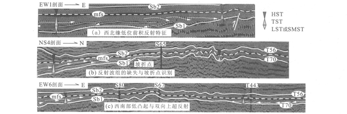
The development of sequence boundaries is usually associated with the eroding peneplaining, fluvial downcutting and tectonic uplifting processes which causes a great reforming of paleogeomorphy. By contrast, sequence patterns and the distributions of the sequences, their systems tracts and parasequences are influenced by paleogeomorphy, indicated by reflection characteristics such as truncation, lapout, progradation angle, regression scope on seismic sections. The sequence stratigraphy analysis here, therefore, provides a powerful tool to identify the paleogeomorphies. Based on the research on the sequence stratigraphy of the Carboniferous, Tahe oilfield, the marks of the onlap pinch-out lines of the first flooding surface and the maximum flooding surface, slope-break lines and folding shapes have been applied to identify the different paleogeomorphic units such as the uplifts, warps of differential compaction, moderately angled slopes, gently angled slopes and depressions during SQ1 and SQ3 sequence developments, firstly revealing an uplifting event caused by tectonic compression before SQ3 sequence. Meanwhile, the planar distribution of sand-bodies of the Ⅱ oil-unit has also been used to verify the results of paleogeomorphy. Through the synthetic analysis above, the authors have found that the sand bodies in lower systems tracts of SQ1 and SQ3 sequence are mainly distributed in the slopes and the depressions consist of the favorable sites of the lithologic trapping target.
The development of sequence boundaries is usually associated with the eroding peneplaining, fluvial downcutting and tectonic uplifting processes which causes a great reforming of paleogeomorphy. By contrast, sequence patterns and the distributions of the sequences, their systems tracts and parasequences are influenced by paleogeomorphy, indicated by reflection characteristics such as truncation, lapout, progradation angle, regression scope on seismic sections. The sequence stratigraphy analysis here, therefore, provides a powerful tool to identify the paleogeomorphies. Based on the research on the sequence stratigraphy of the Carboniferous, Tahe oilfield, the marks of the onlap pinch-out lines of the first flooding surface and the maximum flooding surface, slope-break lines and folding shapes have been applied to identify the different paleogeomorphic units such as the uplifts, warps of differential compaction, moderately angled slopes, gently angled slopes and depressions during SQ1 and SQ3 sequence developments, firstly revealing an uplifting event caused by tectonic compression before SQ3 sequence. Meanwhile, the planar distribution of sand-bodies of the Ⅱ oil-unit has also been used to verify the results of paleogeomorphy. Through the synthetic analysis above, the authors have found that the sand bodies in lower systems tracts of SQ1 and SQ3 sequence are mainly distributed in the slopes and the depressions consist of the favorable sites of the lithologic trapping target.


2003, 28(4): 431-439.
Abstract:
Two most completely outcropped geological sections, Dadili of Yongsheng County and Shangcang of Binchuan County, Yunnan Province, are chosen for Sr, Nd and Pb isotopic geochemical study. Minor samples have the same Pb isotopic composition as C component defined by Hanan & Graham, whereas most of the samples are without C component, suggesting lithospheric materials besides mantle plume. On the diagram of Sr-Nd-Pb, they are plotted within three endmembers, EMⅠ, EMⅡ and DMM. This can be easily explained by different degrees mixing of mantle plume, enriched lithospheric mantle and crustal components. These data, in combination with previous trace element data, indicate that the crustal components are chiefly from lower crust. Basaltic magmas erupted during the early stages of volcanism are susceptible to more crustal contaminations as they establish pathways to the surface. The fertile lithospheric mantle may be related to metasomatism of small melt fractions enriched in Na and P, but poor in K released from mantle plume. Trachyte has the same isotopic compositions as the basalts, implying that it is generated by fractional crystallization.
Two most completely outcropped geological sections, Dadili of Yongsheng County and Shangcang of Binchuan County, Yunnan Province, are chosen for Sr, Nd and Pb isotopic geochemical study. Minor samples have the same Pb isotopic composition as C component defined by Hanan & Graham, whereas most of the samples are without C component, suggesting lithospheric materials besides mantle plume. On the diagram of Sr-Nd-Pb, they are plotted within three endmembers, EMⅠ, EMⅡ and DMM. This can be easily explained by different degrees mixing of mantle plume, enriched lithospheric mantle and crustal components. These data, in combination with previous trace element data, indicate that the crustal components are chiefly from lower crust. Basaltic magmas erupted during the early stages of volcanism are susceptible to more crustal contaminations as they establish pathways to the surface. The fertile lithospheric mantle may be related to metasomatism of small melt fractions enriched in Na and P, but poor in K released from mantle plume. Trachyte has the same isotopic compositions as the basalts, implying that it is generated by fractional crystallization.


2003, 28(4): 441-444.
Abstract:
By showing exhaustive geological results and practical evidence, this article discovers the latest geological event in the lake for the first time-volcanic extrusion and explosion activity, and determines its date and location. The above-mentioned demonstration and the geological information accumulated by the writer for several decades will make it possible to re-understand the evolvement history and manner of the Taihu Lake area, especially after Mesozoic Era, and outline the pre-conditions and intrinsic causes for the lake-basin formation. The Quaternary system changes, archaeological achievements, fossil record of ancient spinal animals and recording on ancient books concerning this area all indicate that the lake actually experienced sinking phenomenon, sinking rate and lake formation. In the end, the author, by providing exhaustive information, expounds the future evolvement law of the Taihu Lake and its adjacent area for planning and developing of the local economy.
By showing exhaustive geological results and practical evidence, this article discovers the latest geological event in the lake for the first time-volcanic extrusion and explosion activity, and determines its date and location. The above-mentioned demonstration and the geological information accumulated by the writer for several decades will make it possible to re-understand the evolvement history and manner of the Taihu Lake area, especially after Mesozoic Era, and outline the pre-conditions and intrinsic causes for the lake-basin formation. The Quaternary system changes, archaeological achievements, fossil record of ancient spinal animals and recording on ancient books concerning this area all indicate that the lake actually experienced sinking phenomenon, sinking rate and lake formation. In the end, the author, by providing exhaustive information, expounds the future evolvement law of the Taihu Lake and its adjacent area for planning and developing of the local economy.


2003, 28(4): 445-454.
Abstract:
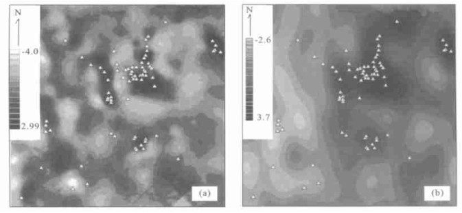
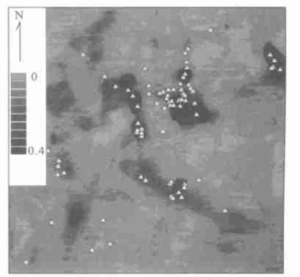
A non-linear mineralization model was proposed on the basis of a classical igneous differentiation mineralization model which can describe the generation of multi-fractal distribution of element concentration as well as grade-tonnage fractal/multi-fractal model. The work has also led to a model to explain the common properties of mineralization and mineralization-associated geochemical anomaly diversity and generalized self-similarity of the anomalies. Generalized self-similarity is related to the generalized scaling invariance which can characterize the external diversity and internal similarity of natural phenomena including mineralization and occurrence of mineral deposits. The models based on core principal of generalized self-similarity and singularity analysis have been applied to a case study of Co-Ni-Ag-As-Pb mineral resources assessment in the Gowganda area of Abitibi district, northern Ontario, Canada. The results have demonstrated that the non-linear models proposed in the current research are effective for delineating week lake sediment and water geochemical anomalies caused by deeply buried sources or week anomalies superimposed to low background values.
A non-linear mineralization model was proposed on the basis of a classical igneous differentiation mineralization model which can describe the generation of multi-fractal distribution of element concentration as well as grade-tonnage fractal/multi-fractal model. The work has also led to a model to explain the common properties of mineralization and mineralization-associated geochemical anomaly diversity and generalized self-similarity of the anomalies. Generalized self-similarity is related to the generalized scaling invariance which can characterize the external diversity and internal similarity of natural phenomena including mineralization and occurrence of mineral deposits. The models based on core principal of generalized self-similarity and singularity analysis have been applied to a case study of Co-Ni-Ag-As-Pb mineral resources assessment in the Gowganda area of Abitibi district, northern Ontario, Canada. The results have demonstrated that the non-linear models proposed in the current research are effective for delineating week lake sediment and water geochemical anomalies caused by deeply buried sources or week anomalies superimposed to low background values.

2003, 28(4): 455-460.
Abstract:
This paper makes a quantitative study, in terms of the geologic setting and characteristics of aqueous system, partition of hydrogeological stage and types of hydraulic pressure system in Huanghua rift basin, of the recovery thickness of sandstone and mudstone, of the extrude output of water and of the intensity of groundwater exchange on each interested layer in its different periods by means of inversion and geostatic pressure and the established mathematical model. The results indicate that the intensities of sedimentary water exchange on each investigated layer in its different periods are less than 1. The cumulative values of the intensities are more than 1 in Es2, Es1, Ed, and less than 1 in Ng, Nm. The infiltration groundwater exchange intensity is 0.44 in Ed. Each investigated layer in its different periods is similar to each other in terms of both the location of high-pressure belt and the flow characteristics in the groundwater flow field. In addition, their major characteristics are centrifugal flow. The study of the initial and modern hydrochemistry and of their evolution shows that the groundwater in the six layers is all of the syndeposit origin in different concentrations. Comparing the modern groundwater concentration with the initial one, except for part of the water in Ek1 layer that remarkably decrease and evolve toward the diluent and reverse metamorphic process, the concentration of groundwater in other five layers increase in different degrees and evolve toward the concentrated sallification and forward metamorphic process. Finally, they all turn into the water of the deuterogenous sedimentary origin in different concentrations.
This paper makes a quantitative study, in terms of the geologic setting and characteristics of aqueous system, partition of hydrogeological stage and types of hydraulic pressure system in Huanghua rift basin, of the recovery thickness of sandstone and mudstone, of the extrude output of water and of the intensity of groundwater exchange on each interested layer in its different periods by means of inversion and geostatic pressure and the established mathematical model. The results indicate that the intensities of sedimentary water exchange on each investigated layer in its different periods are less than 1. The cumulative values of the intensities are more than 1 in Es2, Es1, Ed, and less than 1 in Ng, Nm. The infiltration groundwater exchange intensity is 0.44 in Ed. Each investigated layer in its different periods is similar to each other in terms of both the location of high-pressure belt and the flow characteristics in the groundwater flow field. In addition, their major characteristics are centrifugal flow. The study of the initial and modern hydrochemistry and of their evolution shows that the groundwater in the six layers is all of the syndeposit origin in different concentrations. Comparing the modern groundwater concentration with the initial one, except for part of the water in Ek1 layer that remarkably decrease and evolve toward the diluent and reverse metamorphic process, the concentration of groundwater in other five layers increase in different degrees and evolve toward the concentrated sallification and forward metamorphic process. Finally, they all turn into the water of the deuterogenous sedimentary origin in different concentrations.


2003, 28(4): 461-466.
Abstract:
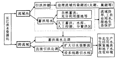
Flood in the Yangtze River is the most serious natural disaster, and in contrast there is great lack of water in North China. Hence, floodwater utilization is put forward as a way to resolve these problems through transforming disaster water into resource water and environment water. Floodwater utilization can not only lessen spatio-temporal unbalance of water resources and frequency of flood and drought and alleviate stress of the increasing need of water in the Yangtze River, but also can be an important measure to resolve the water resources shortage in North China. The storing of floodwater, the basis of floodwater utilization, should be perfected on the valley reservoir network system and at the same time, manpower control should be important in the lake project as well as storing floodwater district construction. The "exchanging land for peace" and "floodwater utilization" can be realized through "giving water a land", and valley lake pollution can be abated through diverting flood to flush lake. It is pointed out that South to North water transfer should divert floodwater mainly through diverting stored floodwater and channel off floodwater directly.
Flood in the Yangtze River is the most serious natural disaster, and in contrast there is great lack of water in North China. Hence, floodwater utilization is put forward as a way to resolve these problems through transforming disaster water into resource water and environment water. Floodwater utilization can not only lessen spatio-temporal unbalance of water resources and frequency of flood and drought and alleviate stress of the increasing need of water in the Yangtze River, but also can be an important measure to resolve the water resources shortage in North China. The storing of floodwater, the basis of floodwater utilization, should be perfected on the valley reservoir network system and at the same time, manpower control should be important in the lake project as well as storing floodwater district construction. The "exchanging land for peace" and "floodwater utilization" can be realized through "giving water a land", and valley lake pollution can be abated through diverting flood to flush lake. It is pointed out that South to North water transfer should divert floodwater mainly through diverting stored floodwater and channel off floodwater directly.
2003, 28(4): 467-470.
Abstract:
GZAF software for Windows98 developed by ourselves using VB and VC supports many of the functions for electron probe analysis, such as hardware setup, drive and correction, quantitative analysis and data process, qualitative analysis, line scanning analysis of large sample, area/line (sem-) quantitative (image) analysis, character X-ray spectrum analysis, thickness measure of film, etc. The analysis reports in text files, 2D/3D graphs or images files. All the reports can use or process by means of general application software such as Office, WPS, Access, Photoshop, etc. Supporting any EPMA with 3 channel spectrometry with a need of only 32 digits interface software, GZAF software also works in half/full off-line mode and serves all EPMA users.
GZAF software for Windows98 developed by ourselves using VB and VC supports many of the functions for electron probe analysis, such as hardware setup, drive and correction, quantitative analysis and data process, qualitative analysis, line scanning analysis of large sample, area/line (sem-) quantitative (image) analysis, character X-ray spectrum analysis, thickness measure of film, etc. The analysis reports in text files, 2D/3D graphs or images files. All the reports can use or process by means of general application software such as Office, WPS, Access, Photoshop, etc. Supporting any EPMA with 3 channel spectrometry with a need of only 32 digits interface software, GZAF software also works in half/full off-line mode and serves all EPMA users.


