2003 Vol. 28, No. 6
Display Method:
2003, 28(6): 583-592.
 PDF 1630KB
Abstract:
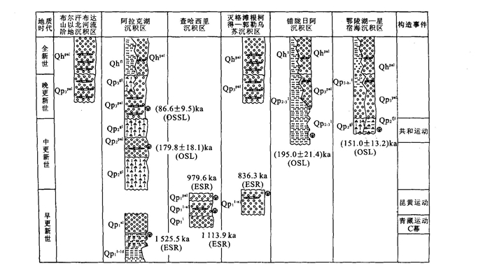
The relief in the eastern Kunlun Mountains, northeast Tibetan plateau is characteristic of a series of NWW-SEE ranges alternating with basins or valleys. The distribution of Quaternary deposits and facies match well with the relief, exposing the mountain building process. The obvious relief differentia first appeared in the north of Buerhanbuda Mountain, represented by the first occurrence of the fluvial deposits at its south foot in the mid-late Early Pleistocene (after 1 525 ka). While the molding of the Maerzheng-Buqing Mountain happened in the later Early Pleistocene, when a so-called Kunlun-Yellow River movement affected an extensive area, the eastern Kunlun Mountains and the headstreams of the Yellow River. The Chahaxili Mountains in the south of our research area were also affected by this event which is inferred by the change from lacustrine deposits to pluvial or alluvial deposits at about 1 113.9-979.6 ka. However, the fact that there are still the deposition area in Chahaxili Mountain area shows that it didn't plump up at that time. Hence, the provenance of the pluvial or alluvial deposits, coming from the north and related to the uplift of the Maerzheng-Buqing Mountain, can be deduced by statistics of the gravel composition and the gravel array. It is concluded that the molding of the Chahaxili Mountains could have occurred in the Late Pleistocene. On the other hand, the good matching relationship between the Pleistocene extension fractures and the relief framework indicates that the mountain building process should be extension-controlled, mainly N-S. This N-S extension should be related to the collapse and equilibrium adjusting of the north edge of the Tibetan plateau caused by gravity unbalance after its being uplifted. The transfer of the mountains building process from north to south implies that the collapse developed from north to south.
The relief in the eastern Kunlun Mountains, northeast Tibetan plateau is characteristic of a series of NWW-SEE ranges alternating with basins or valleys. The distribution of Quaternary deposits and facies match well with the relief, exposing the mountain building process. The obvious relief differentia first appeared in the north of Buerhanbuda Mountain, represented by the first occurrence of the fluvial deposits at its south foot in the mid-late Early Pleistocene (after 1 525 ka). While the molding of the Maerzheng-Buqing Mountain happened in the later Early Pleistocene, when a so-called Kunlun-Yellow River movement affected an extensive area, the eastern Kunlun Mountains and the headstreams of the Yellow River. The Chahaxili Mountains in the south of our research area were also affected by this event which is inferred by the change from lacustrine deposits to pluvial or alluvial deposits at about 1 113.9-979.6 ka. However, the fact that there are still the deposition area in Chahaxili Mountain area shows that it didn't plump up at that time. Hence, the provenance of the pluvial or alluvial deposits, coming from the north and related to the uplift of the Maerzheng-Buqing Mountain, can be deduced by statistics of the gravel composition and the gravel array. It is concluded that the molding of the Chahaxili Mountains could have occurred in the Late Pleistocene. On the other hand, the good matching relationship between the Pleistocene extension fractures and the relief framework indicates that the mountain building process should be extension-controlled, mainly N-S. This N-S extension should be related to the collapse and equilibrium adjusting of the north edge of the Tibetan plateau caused by gravity unbalance after its being uplifted. The transfer of the mountains building process from north to south implies that the collapse developed from north to south.


2003, 28(6): 593-600.
Abstract:
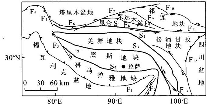
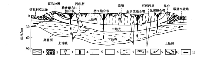
The Qinghai-Tibet plateau, the best field laboratory for continental dynamics, involves many scientific problems in the frontiers and hotspots of modern earth sciences. Up to now, a lot of models including plate tectonics cannot rationally explain key geological and geophysical phenomena related formation and evolution of the plateau. According to a new idea involving coupling between the lower crust and upper crust, orogens and basins, this paper approaches the lower crust laminar tectonic model for uplifting mechanism of Qinghai-Tibet plateau by tectonic analysis of different scales, levels and blocks, multistage evolution. The crustal thicking and tectonic uplift of Qinghai-Tibet plateau result from the thermal softening rocks in the lower crust flow from the Himalayan foreland basin, Tarim basin and Sichuan basin to the plateau during Late Cenozoic era.
The Qinghai-Tibet plateau, the best field laboratory for continental dynamics, involves many scientific problems in the frontiers and hotspots of modern earth sciences. Up to now, a lot of models including plate tectonics cannot rationally explain key geological and geophysical phenomena related formation and evolution of the plateau. According to a new idea involving coupling between the lower crust and upper crust, orogens and basins, this paper approaches the lower crust laminar tectonic model for uplifting mechanism of Qinghai-Tibet plateau by tectonic analysis of different scales, levels and blocks, multistage evolution. The crustal thicking and tectonic uplift of Qinghai-Tibet plateau result from the thermal softening rocks in the lower crust flow from the Himalayan foreland basin, Tarim basin and Sichuan basin to the plateau during Late Cenozoic era.


2003, 28(6): 601-605.
Abstract:
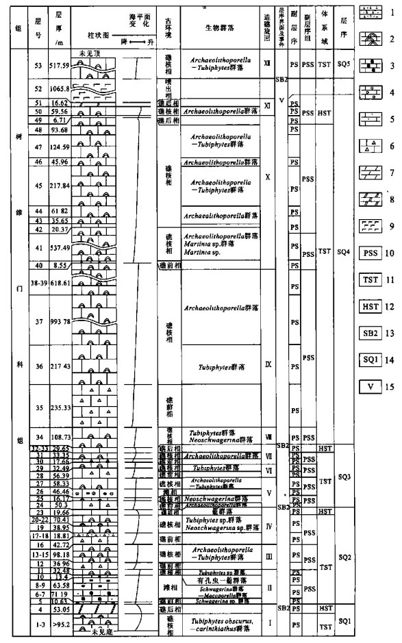
The paper discusses the nature and evolution of reef based on the study of the Early-Middle Permian reef section in Maerzheng, eastern Kunlun and the sequence stratigraphy of the reef. The reef can be divided into 12 reef-building cycles, including 5 third class sequences, on the basis of rock features, biocommunities and sea level changes. Moreover, it puts forward the basic rule of reef development on the continental margin in comparison with those reefs of Early-Middle Permian in eastern Kunlun and in the Yangtz platform.
The paper discusses the nature and evolution of reef based on the study of the Early-Middle Permian reef section in Maerzheng, eastern Kunlun and the sequence stratigraphy of the reef. The reef can be divided into 12 reef-building cycles, including 5 third class sequences, on the basis of rock features, biocommunities and sea level changes. Moreover, it puts forward the basic rule of reef development on the continental margin in comparison with those reefs of Early-Middle Permian in eastern Kunlun and in the Yangtz platform.
2003, 28(6): 606-614.
Abstract:
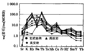
Early Paleozoic volcanic rocks developed in Nuomuhong area can be devided into two types. One is the basic volcanic assemble, mainly consisting of tholeiite basalts with low SiO2 and alkali. Its characteristics of REE, trace elements and tectonic setting reveal that it formed in middle ocean ridge tectonic setting. The other is called middle-basic volcanic assemble with complex rock types and well developed lava and pyroclastics. The volcanic rocks belong to subalkali and alkali series, and the subalkali rocks belong to calalkali series. The charecteristics of REE, trace elements and tectonic setting indicate that they formed in volcanic arc tectonic setting.
Early Paleozoic volcanic rocks developed in Nuomuhong area can be devided into two types. One is the basic volcanic assemble, mainly consisting of tholeiite basalts with low SiO2 and alkali. Its characteristics of REE, trace elements and tectonic setting reveal that it formed in middle ocean ridge tectonic setting. The other is called middle-basic volcanic assemble with complex rock types and well developed lava and pyroclastics. The volcanic rocks belong to subalkali and alkali series, and the subalkali rocks belong to calalkali series. The charecteristics of REE, trace elements and tectonic setting indicate that they formed in volcanic arc tectonic setting.


2003, 28(6): 615-620.
Abstract:
Five important tectonic events in Cenozoic can be divided according to the study of its stratigraphic sequences and relief, drainage system and environment change in the east of the eastern Kunlun Mountains. The first discovery of the paleosoil and paleokarst, including karst breccia and stalactite, on the main planation surface about 5 400 m high in the area suggests that the fine clastic deposits of the upper Tuotuohe Formation and the gypsum deposits of the Wudaoliang Formation are the response to the forming period of the main planation surface in Miocene epoch. The distribution of the main planation surface nowadays shows a range and basin relief style with E-W extension. This elevation differentia reflects disequilibrium in the post-tectonic uplift, which should be the result of differentiated block uplifting since Miocene. While a series of alluvial sand and gravel deposits in middle Early Pleistocene, about 1 525.5 ka, can be regarded as the deposit response to the C episode of the Qinghai-Xizang tectonic movement, reflected in the intensive relief uplifting and formation of the Buerhanbud a Mountain near the Alake Lake. However, in the late Early Pleistocene, about 1 113.9-836.3 ka, lakeshore gravel deposits were deposited first and then they changed into alluvial gravel and sand deposits at the Chahaxili area. This could be regarded as the deposit responsing to the Kunlun-Yellow River movement, indicated in the intensive uplifting and formation of the Maerzheng-Buqing Mountains. The development of the moraine deposits in the early Middle Pleistocene suggested that the elevation in the study area could have reached a hydrosphere frozen altitude after the Kunlun-Yellow River tectonic movement. Whereas the Gonghe tectonic movement is represented by the strong erosion of the Qaidam drainage system before the terrace T5 deposition along the main river, cutting through the main Buerhanbuda Mountain divide, capturing the Gonghe paleolake drainage system, and the unconformity of the Late Pleistocene pluvial and alluvial deposits over the Middle Pleistocene pluvial and alluvial deposits.
Five important tectonic events in Cenozoic can be divided according to the study of its stratigraphic sequences and relief, drainage system and environment change in the east of the eastern Kunlun Mountains. The first discovery of the paleosoil and paleokarst, including karst breccia and stalactite, on the main planation surface about 5 400 m high in the area suggests that the fine clastic deposits of the upper Tuotuohe Formation and the gypsum deposits of the Wudaoliang Formation are the response to the forming period of the main planation surface in Miocene epoch. The distribution of the main planation surface nowadays shows a range and basin relief style with E-W extension. This elevation differentia reflects disequilibrium in the post-tectonic uplift, which should be the result of differentiated block uplifting since Miocene. While a series of alluvial sand and gravel deposits in middle Early Pleistocene, about 1 525.5 ka, can be regarded as the deposit response to the C episode of the Qinghai-Xizang tectonic movement, reflected in the intensive relief uplifting and formation of the Buerhanbud a Mountain near the Alake Lake. However, in the late Early Pleistocene, about 1 113.9-836.3 ka, lakeshore gravel deposits were deposited first and then they changed into alluvial gravel and sand deposits at the Chahaxili area. This could be regarded as the deposit responsing to the Kunlun-Yellow River movement, indicated in the intensive uplifting and formation of the Maerzheng-Buqing Mountains. The development of the moraine deposits in the early Middle Pleistocene suggested that the elevation in the study area could have reached a hydrosphere frozen altitude after the Kunlun-Yellow River tectonic movement. Whereas the Gonghe tectonic movement is represented by the strong erosion of the Qaidam drainage system before the terrace T5 deposition along the main river, cutting through the main Buerhanbuda Mountain divide, capturing the Gonghe paleolake drainage system, and the unconformity of the Late Pleistocene pluvial and alluvial deposits over the Middle Pleistocene pluvial and alluvial deposits.

2003, 28(6): 621-626.
Abstract:
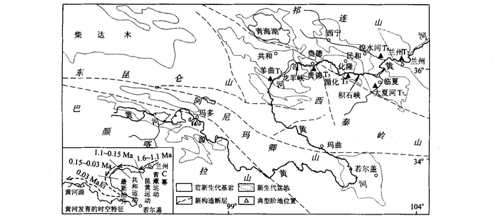
The Cenozoic geomorphological evolution investigation method is used for 1∶250 000 scale geological mapping in Qinghai-Tibet plateau, which clarifies the geomorphological features and geomorphological distributing and their ages and also helps the analysis of geomorphology origin and the relationship of geomorphology, tectonism, climate and sediments. Meanwhile, the investigation of the representatives, planation surfaces and terrace which indicates the uplifting processes also enables us to analyze the geomorphology evolution and reconstruct its history in a certain region. Given the result of investigation on terrace geomorphology in Yangqu of the upper reaches of the Yellow River, the authors deduce that Nanshan, Guinan has been cut through by the Yellow River before 0.03 Ma. The comparison between different terraces in various places of the Yellow River indicates that its geomorphological (evolution) is accompanied by episodic uplifting of the Tibet plateau and related episodic toward the source. Four stages can be recognized here. Firstly, in 1.6 Ma, the Yellow River stabilized in Minhe-Lanzhou-Linxia. Secondly, in 1.1 Ma, it cut through Jishi canyon and arrived in Hualong-Guide. Thirdly, in (0.15 Ma), it appeared in the Gonghe basin after splitting Longyan canyon. Fourthly, after the latest uplifting event around, it cut through Nanshan, Guinan and western Qinling, and reached the source of the Yellow River passing Ruoergai basin.
The Cenozoic geomorphological evolution investigation method is used for 1∶250 000 scale geological mapping in Qinghai-Tibet plateau, which clarifies the geomorphological features and geomorphological distributing and their ages and also helps the analysis of geomorphology origin and the relationship of geomorphology, tectonism, climate and sediments. Meanwhile, the investigation of the representatives, planation surfaces and terrace which indicates the uplifting processes also enables us to analyze the geomorphology evolution and reconstruct its history in a certain region. Given the result of investigation on terrace geomorphology in Yangqu of the upper reaches of the Yellow River, the authors deduce that Nanshan, Guinan has been cut through by the Yellow River before 0.03 Ma. The comparison between different terraces in various places of the Yellow River indicates that its geomorphological (evolution) is accompanied by episodic uplifting of the Tibet plateau and related episodic toward the source. Four stages can be recognized here. Firstly, in 1.6 Ma, the Yellow River stabilized in Minhe-Lanzhou-Linxia. Secondly, in 1.1 Ma, it cut through Jishi canyon and arrived in Hualong-Guide. Thirdly, in (0.15 Ma), it appeared in the Gonghe basin after splitting Longyan canyon. Fourthly, after the latest uplifting event around, it cut through Nanshan, Guinan and western Qinling, and reached the source of the Yellow River passing Ruoergai basin.


2003, 28(6): 627-633.
Abstract:
HP garnet-pyroxenite and the mafic granulites formed by decompression have been found in the high-Himalaya crystallinites (HHC) from Kada-Zaxang near Dingri County, Tibet. The mineral assemblage of the HP garnet-pyroxenite in early stage, Grt+Cpx (rich in Al2O3) +Ru+Q, without any plagioclase, was formed in 845-896 ℃ and 1.2 GPa, with pressure as high as that in eclogitic phase. While the mineral assemblage of mafic granulite was Opx±Cpx (Al-poor) +Pl (An high up to 90) ±Grt (rim), of which the Opx, Cpx and Pl are symplectite which replaced the early Grt and Al-rich clinopyroxene in decompression condition: t=993-776 ℃, p=1.21-0.80 GPa. The latest mineral assemblage, Hb+Pl+Q, found to have replaced the assemblage of mafic granulite, was formed by retrograde metamorphism in amphibolitic phase. All of this show that the HHC have undergone an HP metamorphism and a stage of decompression retrograde metamorphism and that in early stage the temperature rose with the decompression, but in late stage it dropped with the decompression. Therefore, it can be assumed that the uplifting of the HHC was related to the hot source of the mantle.
HP garnet-pyroxenite and the mafic granulites formed by decompression have been found in the high-Himalaya crystallinites (HHC) from Kada-Zaxang near Dingri County, Tibet. The mineral assemblage of the HP garnet-pyroxenite in early stage, Grt+Cpx (rich in Al2O3) +Ru+Q, without any plagioclase, was formed in 845-896 ℃ and 1.2 GPa, with pressure as high as that in eclogitic phase. While the mineral assemblage of mafic granulite was Opx±Cpx (Al-poor) +Pl (An high up to 90) ±Grt (rim), of which the Opx, Cpx and Pl are symplectite which replaced the early Grt and Al-rich clinopyroxene in decompression condition: t=993-776 ℃, p=1.21-0.80 GPa. The latest mineral assemblage, Hb+Pl+Q, found to have replaced the assemblage of mafic granulite, was formed by retrograde metamorphism in amphibolitic phase. All of this show that the HHC have undergone an HP metamorphism and a stage of decompression retrograde metamorphism and that in early stage the temperature rose with the decompression, but in late stage it dropped with the decompression. Therefore, it can be assumed that the uplifting of the HHC was related to the hot source of the mantle.

2003, 28(6): 634-638.
Abstract:
Naxing Formation of Upper Carboniferous in Dingri and Dingjie, Tibet, is a terrigeneous clastic deposit with huge thickness. Gravity flow facies including collapse, debris flow and turbite facies are distinguished firstly in the middle part of the formation. The sedimentary facies and source analysis based on sediment composition and geochemical characteristics reveals that the environment of the area in Late Carboniferous used to be a small fault basin related with the Hercynian extensional movement, and that an extensional unconformity is situated between the gravity flow facies and shore-shelf facies in the lower part of Naxing Formation.
Naxing Formation of Upper Carboniferous in Dingri and Dingjie, Tibet, is a terrigeneous clastic deposit with huge thickness. Gravity flow facies including collapse, debris flow and turbite facies are distinguished firstly in the middle part of the formation. The sedimentary facies and source analysis based on sediment composition and geochemical characteristics reveals that the environment of the area in Late Carboniferous used to be a small fault basin related with the Hercynian extensional movement, and that an extensional unconformity is situated between the gravity flow facies and shore-shelf facies in the lower part of Naxing Formation.


2003, 28(6): 639-644.
Abstract:
The study area lying in the north slope of the middle part of Himalayan orogen involves abundant representative tectonic landforms. Based on the field survey, this paper works out several tectonic landforms: faulting landforms, granite landforms, planation surface landforms, glacier landforms, water system, terrace landforms and earth wood landforms. Then it describes and analyzes the characteristics of those tectonic landforms. All these have provided forceful information for the research of Himalaya's tectonic uplifting and its surface landforms.
The study area lying in the north slope of the middle part of Himalayan orogen involves abundant representative tectonic landforms. Based on the field survey, this paper works out several tectonic landforms: faulting landforms, granite landforms, planation surface landforms, glacier landforms, water system, terrace landforms and earth wood landforms. Then it describes and analyzes the characteristics of those tectonic landforms. All these have provided forceful information for the research of Himalaya's tectonic uplifting and its surface landforms.

2003, 28(6): 645-652.
Abstract:
This paper discusses the uplift and exhumation processes during Mesozoic in Halaguole-Hatu area, east segment of the eastern Kunlun, by dating the zircon and apatite fission-track ages and geobarometer analysis of the hornblende of intermediate-acidic intrusive rocks. The geobarometer analysis of the hornblende of intermediate-acidic intrusive rocks in Hatu area illustrates that the total exhumation range is about 8-9 km since the Late Hercynian-Indosinian, which happened vey slowly, about (20-) 40 m/Ma, from the Early Permian to the early stage of the Late Triassic. While the zircon fission-tract age dating of the samples from different elevations reveals a slow uplift process during the Middle and Late Jurassic. The uplift rate in the Middle Jurassic, 77-88 m/Ma, is correspondingly faster than that in the Late Jurassic, less than 37 m/Ma. This slowing down tendency reflects the gradual decay of the intensive uplift at the boundary time of the Early and Middle Jurassic. The zircon and apatite fission-track age pairs show the exhumation rate is normally less than 55 m/Ma since the Middle Jurassic. Meanwhile, the rock exhumation rate is basically at the same quantity grade as that of its uplift rate, implying that its exhumation and uplifting were in equilibrium on the whole.
This paper discusses the uplift and exhumation processes during Mesozoic in Halaguole-Hatu area, east segment of the eastern Kunlun, by dating the zircon and apatite fission-track ages and geobarometer analysis of the hornblende of intermediate-acidic intrusive rocks. The geobarometer analysis of the hornblende of intermediate-acidic intrusive rocks in Hatu area illustrates that the total exhumation range is about 8-9 km since the Late Hercynian-Indosinian, which happened vey slowly, about (20-) 40 m/Ma, from the Early Permian to the early stage of the Late Triassic. While the zircon fission-tract age dating of the samples from different elevations reveals a slow uplift process during the Middle and Late Jurassic. The uplift rate in the Middle Jurassic, 77-88 m/Ma, is correspondingly faster than that in the Late Jurassic, less than 37 m/Ma. This slowing down tendency reflects the gradual decay of the intensive uplift at the boundary time of the Early and Middle Jurassic. The zircon and apatite fission-track age pairs show the exhumation rate is normally less than 55 m/Ma since the Middle Jurassic. Meanwhile, the rock exhumation rate is basically at the same quantity grade as that of its uplift rate, implying that its exhumation and uplifting were in equilibrium on the whole.


2003, 28(6): 652-652.
Abstract:
2003, 28(6): 653-659.
Abstract:
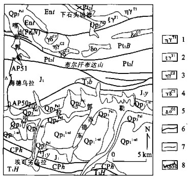
This article studies systematically the petrology and geochemistry of the volcanic rocks of Haidewula area, east Kunlun orogenic belt, Qinghai Province. Based on the section, isotopic dating and regional strata contrasting, it has determined that this suit of volcanic rocks should be Early Jurassic. These volcanic rocks are mainly basic and acid, showing typical "Bi-model" character of rifting, but lacking in intermediate rocks. The basic rocks have a higher alkali degree, while the acid rocks mainly belong to calc series. The volcanic rocks are formed in the rift tectonic environment, split from inner continent among the post orogeny.
This article studies systematically the petrology and geochemistry of the volcanic rocks of Haidewula area, east Kunlun orogenic belt, Qinghai Province. Based on the section, isotopic dating and regional strata contrasting, it has determined that this suit of volcanic rocks should be Early Jurassic. These volcanic rocks are mainly basic and acid, showing typical "Bi-model" character of rifting, but lacking in intermediate rocks. The basic rocks have a higher alkali degree, while the acid rocks mainly belong to calc series. The volcanic rocks are formed in the rift tectonic environment, split from inner continent among the post orogeny.


2003, 28(6): 660-668.
Abstract:
The paper describes the sedimentary environment, basin framework and tectonic paleogeography in different regions in the joint of Qinling, Qilian and eastern Kunlun, Northwest China. It analyzes the facies change, overlapping and time transverse of the strata from Early to Middle Triassic on the basis of rock assemblage and sediment characteristics and fossil assemblages. Then it discusses the rock assemblage and sediment characteristics and age of Naocangjiangou Formation and ended with the revision of its meaning. It is considered that Naocangjiangou Formation could have been formed in from Early to Middle Triassic, consisting of limestone and clastic rocks. The limestone occurs from its bottom to its top with changing facies in between. Furthermore, it expatiates the sedimentary and paleogeographical characters of western Qinling, Qilian and eastern Kunlun.
The paper describes the sedimentary environment, basin framework and tectonic paleogeography in different regions in the joint of Qinling, Qilian and eastern Kunlun, Northwest China. It analyzes the facies change, overlapping and time transverse of the strata from Early to Middle Triassic on the basis of rock assemblage and sediment characteristics and fossil assemblages. Then it discusses the rock assemblage and sediment characteristics and age of Naocangjiangou Formation and ended with the revision of its meaning. It is considered that Naocangjiangou Formation could have been formed in from Early to Middle Triassic, consisting of limestone and clastic rocks. The limestone occurs from its bottom to its top with changing facies in between. Furthermore, it expatiates the sedimentary and paleogeographical characters of western Qinling, Qilian and eastern Kunlun.


2003, 28(6): 669-674.
Abstract:
Sporopollen analysis to aeolian sand section at the east bank of the Alakehu, eastern Kunlun, shows a climate variance process in recent 2 000 a which happened 4 periods of warm and cold alternation. The warm periods occurred during 20-180, 330-410, 700-920 and 1 140-1 380 a respectively, and the cold periods during 180-330, 410-700, 920-1 140 and 1 380-1 920 a. The climates were warm-dry-slightly damp during warm periods and warm-slightly cold and dry during cold period. 700-920 a is the warmest and dampest period in recent 2 000 a, which is implied by the rich of rhus, that mainly distribute in semitropical zone and temperate zone and also rich of arbor sporopollen, and is accorded to the warm period of eastern China in Tang Dynasty which is recorded by the history documents. After 1 500 a, lacking of sporopollen shows that either arbor or herbage decreased sharply when the Little Ice Age came and became almost extinct nowadays. The authors suggest that cooling and drying in (about) 300 a the Little Ice Age is the main reason to the extinction of the arbor, not the people activity.
Sporopollen analysis to aeolian sand section at the east bank of the Alakehu, eastern Kunlun, shows a climate variance process in recent 2 000 a which happened 4 periods of warm and cold alternation. The warm periods occurred during 20-180, 330-410, 700-920 and 1 140-1 380 a respectively, and the cold periods during 180-330, 410-700, 920-1 140 and 1 380-1 920 a. The climates were warm-dry-slightly damp during warm periods and warm-slightly cold and dry during cold period. 700-920 a is the warmest and dampest period in recent 2 000 a, which is implied by the rich of rhus, that mainly distribute in semitropical zone and temperate zone and also rich of arbor sporopollen, and is accorded to the warm period of eastern China in Tang Dynasty which is recorded by the history documents. After 1 500 a, lacking of sporopollen shows that either arbor or herbage decreased sharply when the Little Ice Age came and became almost extinct nowadays. The authors suggest that cooling and drying in (about) 300 a the Little Ice Age is the main reason to the extinction of the arbor, not the people activity.


2003, 28(6): 675-679.
Abstract:
The study on the drainage system in the north slope of the eastern Kunlun Mountains indicates that the E-W trending basin-mountain geomorphology was formed after the Kunlun-Yellow River tectonic movement. This tectonic movement established the early stage of drainage system in which the main river developed along the E-W direction valley. Another important tectonic event, Gonghe tectonic movement, occurred between the Middle Pleistocene and Late Pleistocene, caused the N-S direction rivers to erode quickly southward and capture the drainage system of early stage, when the framework of present drainage pattern was also formed. Then, there was a relatively stable stage during Late Pleistocene. A sequence of thick and large-scale sediments of T5 aged between 52.4 ka and 18.4 ka deposited along most of the rivers during this stage. Since 18.4 ka, the tectonic events in the area have been frequent but with limited intensity. Besides, five terraces were developed after 18.4 ka. The later terraces were upper-overlapping the fifth terrace and did not cut through the deposits of the fifth terrace.
The study on the drainage system in the north slope of the eastern Kunlun Mountains indicates that the E-W trending basin-mountain geomorphology was formed after the Kunlun-Yellow River tectonic movement. This tectonic movement established the early stage of drainage system in which the main river developed along the E-W direction valley. Another important tectonic event, Gonghe tectonic movement, occurred between the Middle Pleistocene and Late Pleistocene, caused the N-S direction rivers to erode quickly southward and capture the drainage system of early stage, when the framework of present drainage pattern was also formed. Then, there was a relatively stable stage during Late Pleistocene. A sequence of thick and large-scale sediments of T5 aged between 52.4 ka and 18.4 ka deposited along most of the rivers during this stage. Since 18.4 ka, the tectonic events in the area have been frequent but with limited intensity. Besides, five terraces were developed after 18.4 ka. The later terraces were upper-overlapping the fifth terrace and did not cut through the deposits of the fifth terrace.

2003, 28(6): 680-684.
Abstract:
The digital processing of the TM image of Laguigangri area, such as K-L transform, K-T transform, and ratio operation has confirmed in the result images, the typical three-layer configuration of Laguigangri metamorphic core complex zone. Moreover, the analysis and contrast of a series of result images have enabled the authors to have summarized the image characteristics of the core, the contact belt and the cover of Laguigangri metamorphic core complex zone. At last, they have put forward the changing law among the Laguigangri metamorphic core complex zone.
The digital processing of the TM image of Laguigangri area, such as K-L transform, K-T transform, and ratio operation has confirmed in the result images, the typical three-layer configuration of Laguigangri metamorphic core complex zone. Moreover, the analysis and contrast of a series of result images have enabled the authors to have summarized the image characteristics of the core, the contact belt and the cover of Laguigangri metamorphic core complex zone. At last, they have put forward the changing law among the Laguigangri metamorphic core complex zone.

2003, 28(6): 685-689.
Abstract:
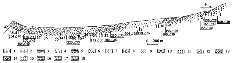
This paper formulates the characteristics of several field survey profiles and the topography and landforms. Dating the strata by OSL, ESR and 14C, the authors establish a stratigraphic system of Early Pleistocene, Middle Pleistocene and Late Pleistocene, which will make it possible for us to classify the Quaternary stratum system accurately in the study area. This may provide important information for the research on Late Cenozoic tectonic uplifting, tectonic landforms and environment.
This paper formulates the characteristics of several field survey profiles and the topography and landforms. Dating the strata by OSL, ESR and 14C, the authors establish a stratigraphic system of Early Pleistocene, Middle Pleistocene and Late Pleistocene, which will make it possible for us to classify the Quaternary stratum system accurately in the study area. This may provide important information for the research on Late Cenozoic tectonic uplifting, tectonic landforms and environment.


2003, 28(6): 690-694.
Abstract:
Laguigangri Mountains are composed of a series of chain-like swellings trending west and east. They all are vaults where there are a lot of metamorphic rocks and detachment faults, and so they are naturally related to each other. The research of chemical composition and metamorphic zonation and estimation of p-T of characteristic metamorphic minerals from metamorphic zone in Laguigangri has revealed the regularity of composition, temperature and pressure and metamorphic depth. This will evidence the activities of the metamorphic core and the detachment fault.
Laguigangri Mountains are composed of a series of chain-like swellings trending west and east. They all are vaults where there are a lot of metamorphic rocks and detachment faults, and so they are naturally related to each other. The research of chemical composition and metamorphic zonation and estimation of p-T of characteristic metamorphic minerals from metamorphic zone in Laguigangri has revealed the regularity of composition, temperature and pressure and metamorphic depth. This will evidence the activities of the metamorphic core and the detachment fault.


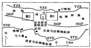
2003, 28(6): 695-701.
Abstract:
Laguigangri metamorphic core complexes (MCC) occurred in paternoster shape in south Tibet. Leucogranites, distributed in the core or detachment of the MCC, form the famous northern Himalayan leucogranites belt. They actively emplaced and occurred in two periods: early biotite leucogranites and late muscovite leucogranites. With high SiO2 and Al2O3, the leucogranites have muscovite±tourmaline±garnet aluminous minerals and so do S-type granites. The crystalline of the northern Himalayan leucogranites is dated 17-10 Ma, whose source is the para-metamorphical rocks in the high Himalayan crystalline basement on top of the MCT. The magma resulted from decompression during the conversion of the structural mechanism. Simultaneously, the pressure decompression caused more plastic lower crust and the liquid layer in younger orogen to rise to the upper crust and formed the MCC. It is found that the magma speeds the formation of the MCC.
Laguigangri metamorphic core complexes (MCC) occurred in paternoster shape in south Tibet. Leucogranites, distributed in the core or detachment of the MCC, form the famous northern Himalayan leucogranites belt. They actively emplaced and occurred in two periods: early biotite leucogranites and late muscovite leucogranites. With high SiO2 and Al2O3, the leucogranites have muscovite±tourmaline±garnet aluminous minerals and so do S-type granites. The crystalline of the northern Himalayan leucogranites is dated 17-10 Ma, whose source is the para-metamorphical rocks in the high Himalayan crystalline basement on top of the MCT. The magma resulted from decompression during the conversion of the structural mechanism. Simultaneously, the pressure decompression caused more plastic lower crust and the liquid layer in younger orogen to rise to the upper crust and formed the MCC. It is found that the magma speeds the formation of the MCC.


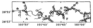
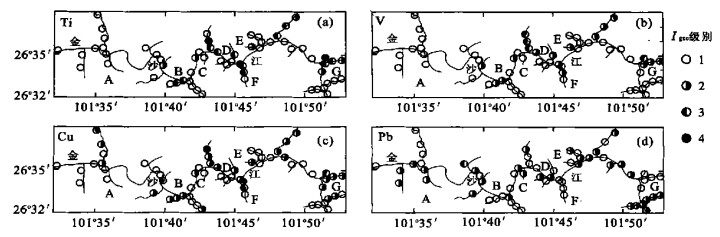
2003, 28(6): 702-706.
Abstract:
The study objective is to investigate the feasibility of using XRF technique to research mining environmental geochemistry and to reveal the pattern of trace elements in mining environment. A high sensitive EDXRF analyzer was adopted to study environmental geochemistry in Panzhihua region. An EDXRF analyzer is made up of a double exciting apparatus with low energy X ray tube and isotope source and electricity cooled Sin PIN detector. The analyzer is characterized of high energy resolution and low detection limit. Some trace metal concentration was analyzed by above EDXRF analyzer in stream sediments in study area. The result shows that XRF can analyze concentrations of chemical elements in stream sediments and study the characteristics of environmental geochemistry.
The study objective is to investigate the feasibility of using XRF technique to research mining environmental geochemistry and to reveal the pattern of trace elements in mining environment. A high sensitive EDXRF analyzer was adopted to study environmental geochemistry in Panzhihua region. An EDXRF analyzer is made up of a double exciting apparatus with low energy X ray tube and isotope source and electricity cooled Sin PIN detector. The analyzer is characterized of high energy resolution and low detection limit. Some trace metal concentration was analyzed by above EDXRF analyzer in stream sediments in study area. The result shows that XRF can analyze concentrations of chemical elements in stream sediments and study the characteristics of environmental geochemistry.