2004 Vol. 29, No. 2
Display Method:
2004, 29(2): 127-133.
 PDF 466KB
Abstract:
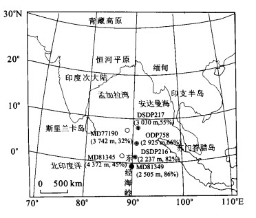
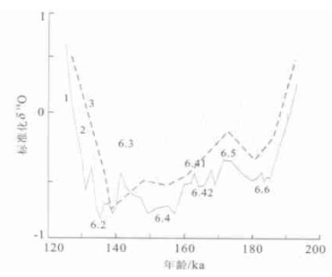
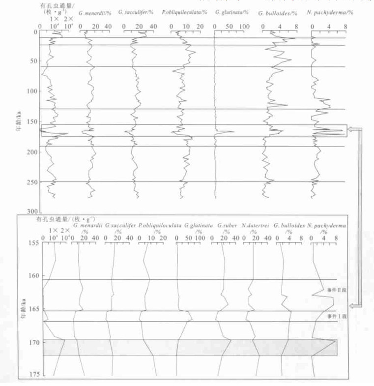
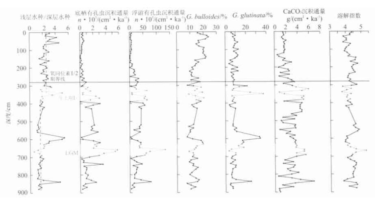
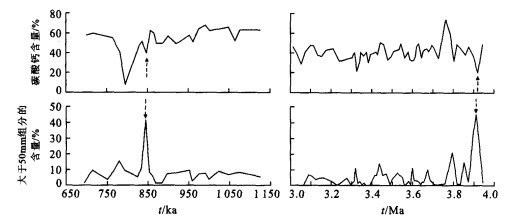
The pelagic sedimentary records conserved on the equatorial Ninetyeast Ridge have mirrored a significant event dating from the early oxygen isotope stage 6(167-160 ka). We call it the"great event of worsened ecologic environment" because the strongest indications of the event among all proxies are from an exceptional change of assemblage and flux of planktonic foraminifera. The event is characterized by a high development of the eurytropic species Globigerinita glutinata, an unusual promotion of the cool-water species Neogloboquadrina pachyderma and Globigerina bulloides, an evident reduction of the major common species and a large downfall of the foraminifera sedimentary quantity. Referring to the otherindications and the materials from the neighboring areas, we believe that the essential factor resulting in the eventis "ultraintense" south Asian winter monsoon that leads to the lower temperature of superficialwater and upwelling of infertile deeperwater. In general, the wintermonsoon ismuchweaker than summermonsoon for affecting the environmentof the study area in the system of the south Asian monsoon. Its periodic extraordinary intensification seems to relate constantly with the violent uplift of the Tibetan plateau. We guess thatthe"great event of worsened ecologic environment" revealed in this paperis very probably the resultof the last extensive tectonic elevation of the plateau.
The pelagic sedimentary records conserved on the equatorial Ninetyeast Ridge have mirrored a significant event dating from the early oxygen isotope stage 6(167-160 ka). We call it the"great event of worsened ecologic environment" because the strongest indications of the event among all proxies are from an exceptional change of assemblage and flux of planktonic foraminifera. The event is characterized by a high development of the eurytropic species Globigerinita glutinata, an unusual promotion of the cool-water species Neogloboquadrina pachyderma and Globigerina bulloides, an evident reduction of the major common species and a large downfall of the foraminifera sedimentary quantity. Referring to the otherindications and the materials from the neighboring areas, we believe that the essential factor resulting in the eventis "ultraintense" south Asian winter monsoon that leads to the lower temperature of superficialwater and upwelling of infertile deeperwater. In general, the wintermonsoon ismuchweaker than summermonsoon for affecting the environmentof the study area in the system of the south Asian monsoon. Its periodic extraordinary intensification seems to relate constantly with the violent uplift of the Tibetan plateau. We guess thatthe"great event of worsened ecologic environment" revealed in this paperis very probably the resultof the last extensive tectonic elevation of the plateau.

2004, 29(2): 135-140.
Abstract:
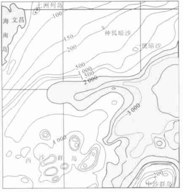
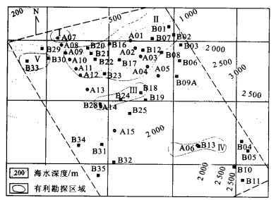
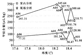
Researches of gas hydrate involve cross-disciplinary data from geophysics, geochemistry and geology. Geochemical technologies can be used to collect the trace amount geochemical data about gas hydrate from seafloor media which will indicate the abnormal region. The original data was collected in the marine science investigation about gas hydrate in 2000 and 2001. After further indoor analysis and testing of multiple hydrocarbons, the abnormal region of marine gas hydrate was indicated, and the evaluation results were also derived from comparative analysis of seismic BSR and BZ about gas hydrate. With the on-site isotope data, the resulting cause about gas hydrate methane was discussed. These achievements will provide direct geochemical evidences for the exploration of gas hydrate at Xisha ocean trough.
Researches of gas hydrate involve cross-disciplinary data from geophysics, geochemistry and geology. Geochemical technologies can be used to collect the trace amount geochemical data about gas hydrate from seafloor media which will indicate the abnormal region. The original data was collected in the marine science investigation about gas hydrate in 2000 and 2001. After further indoor analysis and testing of multiple hydrocarbons, the abnormal region of marine gas hydrate was indicated, and the evaluation results were also derived from comparative analysis of seismic BSR and BZ about gas hydrate. With the on-site isotope data, the resulting cause about gas hydrate methane was discussed. These achievements will provide direct geochemical evidences for the exploration of gas hydrate at Xisha ocean trough.


2004, 29(2): 141-147.
Abstract:
Calcareous nannofossils in 2 Co-rich ferromanganese crusts, N1-15 and N5E-06, from the central Pacific seamounts were analyzed in order to estimate their depositional ages. These 2 crusts show 3 structural layers: compact upper layer, porous middle layer and compact lower layer. 12 Tertiary to Quaternary nannofossil eventswere recognized. The upper layers of these 2 crustswere deposited since Late Pleistocene, while their middle layers were formed from Pliocene to Middle Pleistocene. The age of the lowest sample from N5E-06 crustwas estimated as 55.3-59.7 Ma in the Middle to Late Paleocene, and the duration for lower part of the lower layer was given between 59.7-32.8 Ma from the Middle Paleocene and Early Oligocene.For the lower layerof N1-15 crust, the age was roughly determined to be Miocene, due to the lack of reliable fossils. This study notes that no reliable Late Oligocene to Miocene nannofossil markers were found in these 2 crusts. Furthermore, sedimentation hiatus was observed.
Calcareous nannofossils in 2 Co-rich ferromanganese crusts, N1-15 and N5E-06, from the central Pacific seamounts were analyzed in order to estimate their depositional ages. These 2 crusts show 3 structural layers: compact upper layer, porous middle layer and compact lower layer. 12 Tertiary to Quaternary nannofossil eventswere recognized. The upper layers of these 2 crustswere deposited since Late Pleistocene, while their middle layers were formed from Pliocene to Middle Pleistocene. The age of the lowest sample from N5E-06 crustwas estimated as 55.3-59.7 Ma in the Middle to Late Paleocene, and the duration for lower part of the lower layer was given between 59.7-32.8 Ma from the Middle Paleocene and Early Oligocene.For the lower layerof N1-15 crust, the age was roughly determined to be Miocene, due to the lack of reliable fossils. This study notes that no reliable Late Oligocene to Miocene nannofossil markers were found in these 2 crusts. Furthermore, sedimentation hiatus was observed.


2004, 29(2): 148-150.
Abstract:
It is significant to study the relationship between Co-rich crust composition and its growing environmentfor accurate estimate and rational utilization of this future resource. The authors present carbon isotope data of organic matter in Co-rich ferromanganese crust from central Pacific seamount area. The value of δ13Corg ranges from -21.86×10⁻³ to -23.99×10⁻³, implying that the organic matter origins from marine organism. The carbon isotopic composition of organic matter fluctuates during the growth of Co-rich crust and responds to marine environment and global climate change. Hence, it can be a useful proxy for paleoceanography.
It is significant to study the relationship between Co-rich crust composition and its growing environmentfor accurate estimate and rational utilization of this future resource. The authors present carbon isotope data of organic matter in Co-rich ferromanganese crust from central Pacific seamount area. The value of δ13Corg ranges from -21.86×10⁻³ to -23.99×10⁻³, implying that the organic matter origins from marine organism. The carbon isotopic composition of organic matter fluctuates during the growth of Co-rich crust and responds to marine environment and global climate change. Hence, it can be a useful proxy for paleoceanography.

2004, 29(2): 151-156.
Abstract:
Indonesian throughflow is the important carrier of the heat transport between the western Pacific Ocean and the Indian Ocean. Throughflow actions affect the global climate changes by influencing potentially El Nino events and monsoon actions. Based on the studies of the oxygen isotope, the mass accumulation rates of foraminifera and CaCO3, the thermocline estimated by the ratio of the planktonic foraminifera shallow-dwelling species and deep-dwelling species, we know that the throughflowwasweak during the last glacial oxygen isotope stage 2, and enhanced during the interglacial oxygen isotope stage 1. Especially in the deglaciation termination ⅠA, the throughflow changed rapidly from weak to strong. This is due to the ice sheetmelting, sea level rising, and the Indonesian Archipelagowater pathways opening.
Indonesian throughflow is the important carrier of the heat transport between the western Pacific Ocean and the Indian Ocean. Throughflow actions affect the global climate changes by influencing potentially El Nino events and monsoon actions. Based on the studies of the oxygen isotope, the mass accumulation rates of foraminifera and CaCO3, the thermocline estimated by the ratio of the planktonic foraminifera shallow-dwelling species and deep-dwelling species, we know that the throughflowwasweak during the last glacial oxygen isotope stage 2, and enhanced during the interglacial oxygen isotope stage 1. Especially in the deglaciation termination ⅠA, the throughflow changed rapidly from weak to strong. This is due to the ice sheetmelting, sea level rising, and the Indonesian Archipelagowater pathways opening.


2004, 29(2): 157-162.
Abstract:
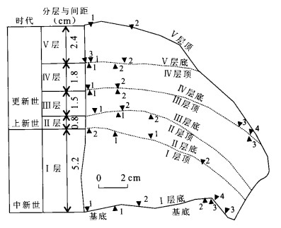
The pelagic sediments of Ninetyeast ridge have been synthetically analyzed through paleobiostratigraphy, carbonate stratigraphy, X-ray crystal powder diffraction and grain size analysis. The grain size of terrigenous sediments has been regarded as a cut-in in the discussion of sedimentation, sources and possible carrying mechanisms of the sediments. The source and carrying pattern of the terrigenous sediments have been supplemented further. The grain size of the terrigenous sediments can serve as an indicator of southeast monsoon or equatorial east wind. Its change not only reflects the volcanic activity of the source region of the terrigenous sediments but also indicates the wind strength. However, the quantity of the terrigenous sediments mainly depends on the erosion of the Tibetan plateau and Indian subcontinent and the runoff. The two aspects have been associated by the uplift of the plateau and its environmental effects.
The pelagic sediments of Ninetyeast ridge have been synthetically analyzed through paleobiostratigraphy, carbonate stratigraphy, X-ray crystal powder diffraction and grain size analysis. The grain size of terrigenous sediments has been regarded as a cut-in in the discussion of sedimentation, sources and possible carrying mechanisms of the sediments. The source and carrying pattern of the terrigenous sediments have been supplemented further. The grain size of the terrigenous sediments can serve as an indicator of southeast monsoon or equatorial east wind. Its change not only reflects the volcanic activity of the source region of the terrigenous sediments but also indicates the wind strength. However, the quantity of the terrigenous sediments mainly depends on the erosion of the Tibetan plateau and Indian subcontinent and the runoff. The two aspects have been associated by the uplift of the plateau and its environmental effects.


2004, 29(2): 163-168.
Abstract:
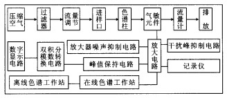
In order to improve the sensitivity and selectivity and to increase the detectable gas compositions, the chemical gas sensor is investigated and applied to explore natural gas and oil in sea. The sensor has the advantage over the traditional equipments, including high sensitivity, small magnitude, low weight, low power, easy manipulation, and also being able to work under the worst condition in sea. Different kinds of sensors are able to be installed on a chip, simultaneously testing diverse chemicals. The sensor can also be connected to the computer, directly process the data. Thus, it is specially suitable for exploring gas and oil in sea. Based on the chemical sensors, this sensor is the first detection system successfully investigated for the gaseous hydrocarbon and hydrogen in the world, which is able to be easily carried with high sensitivity. The sensor can directly measure the quantities of the over-trace methane, ethane, propane and hydrogen in the sample. The detection limit is 10-10 g. Its selectivity, repeatability, stability and life-time have reached to the advanced level in the world. Not only can the sensor be used to explore gas and oil in sea, but also can be used to test other over-trace gases in any field.
In order to improve the sensitivity and selectivity and to increase the detectable gas compositions, the chemical gas sensor is investigated and applied to explore natural gas and oil in sea. The sensor has the advantage over the traditional equipments, including high sensitivity, small magnitude, low weight, low power, easy manipulation, and also being able to work under the worst condition in sea. Different kinds of sensors are able to be installed on a chip, simultaneously testing diverse chemicals. The sensor can also be connected to the computer, directly process the data. Thus, it is specially suitable for exploring gas and oil in sea. Based on the chemical sensors, this sensor is the first detection system successfully investigated for the gaseous hydrocarbon and hydrogen in the world, which is able to be easily carried with high sensitivity. The sensor can directly measure the quantities of the over-trace methane, ethane, propane and hydrogen in the sample. The detection limit is 10-10 g. Its selectivity, repeatability, stability and life-time have reached to the advanced level in the world. Not only can the sensor be used to explore gas and oil in sea, but also can be used to test other over-trace gases in any field.


2004, 29(2): 169-176.
Abstract:
Dabie-Sulu UHP terrane, central China, extends from western Tongbai Mountains through the Dabie Mountains to Sulu. The garnet-bearing granites account for more than 85% in volume in the UHP units, with a mineral assemblage of Or+Ab+Q+Bi+Mc+Grt+Zr+Ep+Ae+Hb. In some profiles where larger eclogute bodies occurred, there is a gradual transition from eclogite →amphibolite (frequently with symplecites of plagioclase+ amphibole) →garnet-bearing gneisses→garnet-bearing granite. The gneisses occur as relics or bands of several centimeters to several meters in the garnet-bearing granites. The bands are parallel to the foliation of garnet-bearing granites. All these spatial distributions result from the partial melting and transformation of structural regime. The garnet-bearing granites have w(SiO2)=71.73%-79.15%; A/CNK=0.83-1.09; w(K2O+Na2O)=6.15%-9.00%, w(K2O)/w(Na2O)=0.16-1.54. They are in the range of weakly peralkaline to weakly peraluminous series. In trace elements, the garnet-bearing granites have w(Zr)/w(Hf)=20.40~48.99 (averaging 35.13), w(Nb)/w(Ta)=6.93-22.28 (averaging 13.24), w(Zr)/w (Nb)=7.42-226.82 (averaging 37.34), and w(∑REE) =56.61×10⁻⁶-795.58×10⁻⁶. All samples of the garnet-bearing granites show obvious Eu negative (anomaly). While in primitive mantle-normalized spider diagram, the garnet-bearing granites are relatively rich in K, Ba, Pb, Nd, Y and La and relatively depleted in Nb, Ta, Sr, Ti, Zr and P. Combined with another characteristics such as high SiO2, (K2O+Na2O), Ga and low Al2O3, CaO, MgO, the garnet-bearing foliated granites are similar to A-type granites. From Dabie to Sulu, the content of SiO2, (K2O+Na2O), ∑REE, Ga and the ratios of w(K2O)/w(Na2O), (Fe/Mg)M and w(Zr)/w(Hf) increase gradually; the content of Al2O3, CaO, MgO, Sr and the ratio of w(Nb)/w(Ta) decrease gradually. The emplacement level for garnet-bearing granites in Sulu is lower than that in Dabie.
Dabie-Sulu UHP terrane, central China, extends from western Tongbai Mountains through the Dabie Mountains to Sulu. The garnet-bearing granites account for more than 85% in volume in the UHP units, with a mineral assemblage of Or+Ab+Q+Bi+Mc+Grt+Zr+Ep+Ae+Hb. In some profiles where larger eclogute bodies occurred, there is a gradual transition from eclogite →amphibolite (frequently with symplecites of plagioclase+ amphibole) →garnet-bearing gneisses→garnet-bearing granite. The gneisses occur as relics or bands of several centimeters to several meters in the garnet-bearing granites. The bands are parallel to the foliation of garnet-bearing granites. All these spatial distributions result from the partial melting and transformation of structural regime. The garnet-bearing granites have w(SiO2)=71.73%-79.15%; A/CNK=0.83-1.09; w(K2O+Na2O)=6.15%-9.00%, w(K2O)/w(Na2O)=0.16-1.54. They are in the range of weakly peralkaline to weakly peraluminous series. In trace elements, the garnet-bearing granites have w(Zr)/w(Hf)=20.40~48.99 (averaging 35.13), w(Nb)/w(Ta)=6.93-22.28 (averaging 13.24), w(Zr)/w (Nb)=7.42-226.82 (averaging 37.34), and w(∑REE) =56.61×10⁻⁶-795.58×10⁻⁶. All samples of the garnet-bearing granites show obvious Eu negative (anomaly). While in primitive mantle-normalized spider diagram, the garnet-bearing granites are relatively rich in K, Ba, Pb, Nd, Y and La and relatively depleted in Nb, Ta, Sr, Ti, Zr and P. Combined with another characteristics such as high SiO2, (K2O+Na2O), Ga and low Al2O3, CaO, MgO, the garnet-bearing foliated granites are similar to A-type granites. From Dabie to Sulu, the content of SiO2, (K2O+Na2O), ∑REE, Ga and the ratios of w(K2O)/w(Na2O), (Fe/Mg)M and w(Zr)/w(Hf) increase gradually; the content of Al2O3, CaO, MgO, Sr and the ratio of w(Nb)/w(Ta) decrease gradually. The emplacement level for garnet-bearing granites in Sulu is lower than that in Dabie.


2004, 29(2): 177-182.
Abstract:
Rock weathering caused by the carbonic acid reaction with minerals to produce dissolved bicarbonates carried by rivers to the oceans is an important part in carbon cycle. The process causes significant carbon dioxide consumption, the accurate calculation of which may partly explain the missing sink of carbon. The CO2 uptaken by carbonate dissolution on the continents is counterbalanced by the CO2 release carbonate precipitation in the ocean. The same is not true for silicate weathering. Silicate weathering is more important than carbonate weathering as a long-term control on atmospheric CO2. A global erosion model (GEM-CO2) developed by Amiotte Suchet allows us to calculate the flux of atmospheric/soil CO2 consumed by chemical erosion of continental rocks. In this paper, the CO2 consumption by rock weathering in China is estimated based on GEM-CO2 and the Chinese Resources and Environment Database, whose distribution is shown in a GRID map with a spatial resolution of 1 000 m×1 000 m. The total carbon consumption is about 4.72×10⁷ t/a, about 52.65% of which are caused by carbonate. The model results are close to previous estimation of other researches. The flux of CO2 consumed by rock weathering increases where carbonate rock outcrops are more abundant and when drainage intensity increases. The results show that the main consumption of CO2 is localized in Guangxi, Guizhou and Chongqing provinces, and west Hubei Province and southwest Hunan Province, because of a high proportion of carbonate rocks and high humidity in a large area.
Rock weathering caused by the carbonic acid reaction with minerals to produce dissolved bicarbonates carried by rivers to the oceans is an important part in carbon cycle. The process causes significant carbon dioxide consumption, the accurate calculation of which may partly explain the missing sink of carbon. The CO2 uptaken by carbonate dissolution on the continents is counterbalanced by the CO2 release carbonate precipitation in the ocean. The same is not true for silicate weathering. Silicate weathering is more important than carbonate weathering as a long-term control on atmospheric CO2. A global erosion model (GEM-CO2) developed by Amiotte Suchet allows us to calculate the flux of atmospheric/soil CO2 consumed by chemical erosion of continental rocks. In this paper, the CO2 consumption by rock weathering in China is estimated based on GEM-CO2 and the Chinese Resources and Environment Database, whose distribution is shown in a GRID map with a spatial resolution of 1 000 m×1 000 m. The total carbon consumption is about 4.72×10⁷ t/a, about 52.65% of which are caused by carbonate. The model results are close to previous estimation of other researches. The flux of CO2 consumed by rock weathering increases where carbonate rock outcrops are more abundant and when drainage intensity increases. The results show that the main consumption of CO2 is localized in Guangxi, Guizhou and Chongqing provinces, and west Hubei Province and southwest Hunan Province, because of a high proportion of carbonate rocks and high humidity in a large area.

2004, 29(2): 183-190.
Abstract:
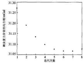
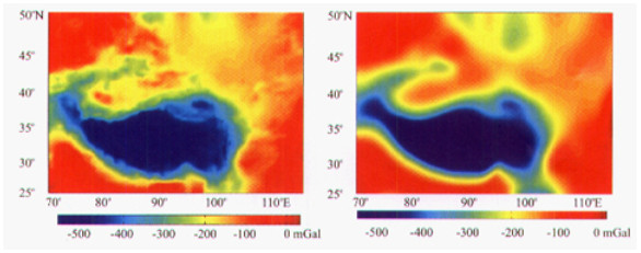
Western China has the most spectacular tectonic features on the continental Earth. It possesses the world highest plateau (Tibet), the world largest intra-continental strike-slip fault (Altyn Tagh) and the world highest intra-continental mountain belt (Tienshan Mountains). As the convergence belt between India plate and Europe plate, this region is a good place for the study of lithosphere dynamics. In this paper, the authors use gravity data and topography data to demonstrate the correlation of these conspicuous upper crustal structures with the deformation of the upper mantle lithosphere in China. we compute the effective elastic thickness of the elastic plate using three-dimensional finite difference in space domain according to the rheology of the continental lithosphere. This model considers the variation of the mechanical strength in vertical and horizontal orientation. The modeling results show that the effective elastic thickness of the lithosphere in China varies significantly from elastic thickness of 6-10 km in highly deformed mountain belts to over 60 km in stable platform areas. The effective elastic thickness of Tibet, Tarim, southern Tienshan and northern Tienshan are separately 30, 40-50, 10-15 and 30 km. While the effective elastic thickness in the western portion of the Altyn Tagh fault (west of 90°E) is less than that in the eastern portion.
Western China has the most spectacular tectonic features on the continental Earth. It possesses the world highest plateau (Tibet), the world largest intra-continental strike-slip fault (Altyn Tagh) and the world highest intra-continental mountain belt (Tienshan Mountains). As the convergence belt between India plate and Europe plate, this region is a good place for the study of lithosphere dynamics. In this paper, the authors use gravity data and topography data to demonstrate the correlation of these conspicuous upper crustal structures with the deformation of the upper mantle lithosphere in China. we compute the effective elastic thickness of the elastic plate using three-dimensional finite difference in space domain according to the rheology of the continental lithosphere. This model considers the variation of the mechanical strength in vertical and horizontal orientation. The modeling results show that the effective elastic thickness of the lithosphere in China varies significantly from elastic thickness of 6-10 km in highly deformed mountain belts to over 60 km in stable platform areas. The effective elastic thickness of Tibet, Tarim, southern Tienshan and northern Tienshan are separately 30, 40-50, 10-15 and 30 km. While the effective elastic thickness in the western portion of the Altyn Tagh fault (west of 90°E) is less than that in the eastern portion.


2004, 29(2): 191-197.
Abstract:
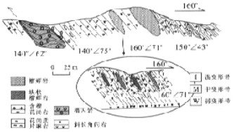
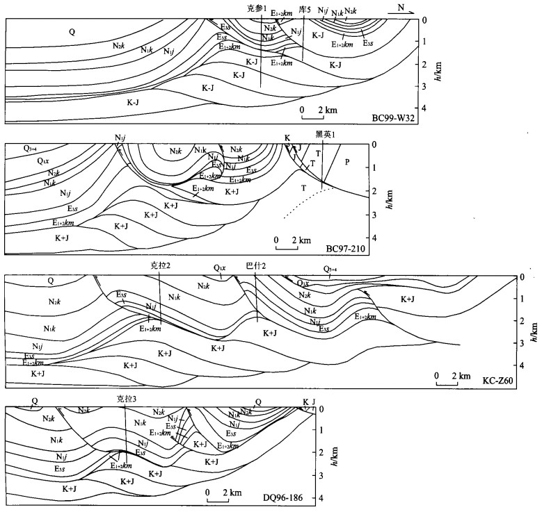
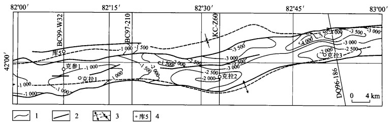
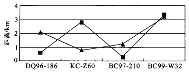
The field observation and seismic data interpretation reveal that the displacement transfer zone is developed in the Kelasu triangle zone, Kuqa thrust-and-fold belts. The displacement transfer zone appears as relay ramps of the Kumugeliemu anticlines, Bashijiqike anticlines, Kaiyileiaiken anticlines to the north and Tuzimazha anticlines, Kasangtuokai anticlines, and Jidike anticlines to the south on the surface, respectively. Under the subsurface, it appears as throw deviation of Kumugeliemu-Bashijiqike thrusts and Kasangtuokai thrusts. Its dynamic occurrence may be related to the gravitational slide structures along the southern Chinese Tianshan front ranges.
The field observation and seismic data interpretation reveal that the displacement transfer zone is developed in the Kelasu triangle zone, Kuqa thrust-and-fold belts. The displacement transfer zone appears as relay ramps of the Kumugeliemu anticlines, Bashijiqike anticlines, Kaiyileiaiken anticlines to the north and Tuzimazha anticlines, Kasangtuokai anticlines, and Jidike anticlines to the south on the surface, respectively. Under the subsurface, it appears as throw deviation of Kumugeliemu-Bashijiqike thrusts and Kasangtuokai thrusts. Its dynamic occurrence may be related to the gravitational slide structures along the southern Chinese Tianshan front ranges.


2004, 29(2): 198-202.
Abstract:
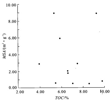
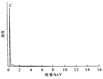
More and more evidences indicate that the organic matter (OM) in immature organic-rich sediments and sedimentary rocks is chemically absorbed onto the external surfaces of minerals and into interlayer (internal) surfaces of smectitic clay minerals in the form of amorphous molecular scale carbon OM. But there are few reports about the occurrence of high mature OM in marine black shale petroleum source rocks. This paper studies the occurrence of high mature OM in the black shale of basal Cambrian from the northern Tarim basin. Based on the comprehensive analysis of total organic carbon contents (TOC), maximum thermolysis temperatures (Tmax) of OM, mineral surface areas (MSA), scanning electronic microscope (SEM) and transmission electronic microscope (TEM) of the black shale, it concludes that the high mature OM in the marine black shale of the basal Cambrian from the basin occurs in the state of particulates ranging from 1 to 5 microns in diameter. The contrast of the existing state of the high mature OM in the black shale with that of the immature one in the modern marine continental margin sediments has brought some scientific problems, which are valuable to study in detail.
More and more evidences indicate that the organic matter (OM) in immature organic-rich sediments and sedimentary rocks is chemically absorbed onto the external surfaces of minerals and into interlayer (internal) surfaces of smectitic clay minerals in the form of amorphous molecular scale carbon OM. But there are few reports about the occurrence of high mature OM in marine black shale petroleum source rocks. This paper studies the occurrence of high mature OM in the black shale of basal Cambrian from the northern Tarim basin. Based on the comprehensive analysis of total organic carbon contents (TOC), maximum thermolysis temperatures (Tmax) of OM, mineral surface areas (MSA), scanning electronic microscope (SEM) and transmission electronic microscope (TEM) of the black shale, it concludes that the high mature OM in the marine black shale of the basal Cambrian from the basin occurs in the state of particulates ranging from 1 to 5 microns in diameter. The contrast of the existing state of the high mature OM in the black shale with that of the immature one in the modern marine continental margin sediments has brought some scientific problems, which are valuable to study in detail.


2004, 29(2): 203-210.
Abstract:
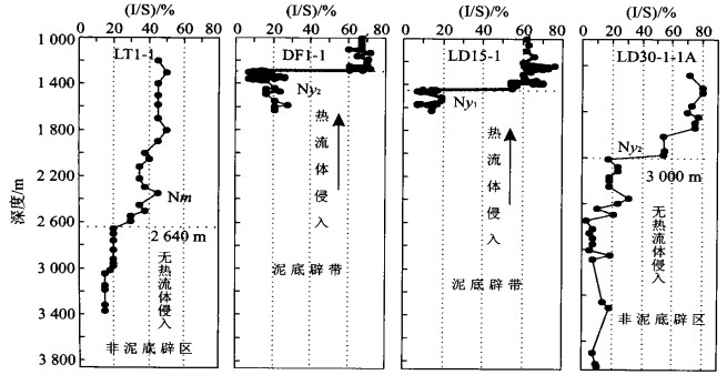
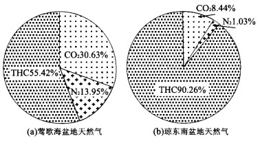
The Yinggehai basin is a young but high geotemperature basin that was developed in the Cenozoic at the northern continental margin of South China Sea. Its high geotemperature and heat flow fields are mainly located in the mud-fluid diapir structure areas in the center of the basin. The development and evolution of the mud-fluid diapir, especially the upwelling of heat flow in the Late Pliocene, is closely related with the migration and accumulation of natural gas and carbon dioxide. The local invasion of heat flow, whose distribution is inhomogeneous in different zones and formations, leads to the migration and accumulation of hydrocarbon and carbon dioxide sourced from crust and mantle to hold the same characteristics. While the upwelling of heat flow in mud-fluid diapir areas is the main factor that influences the migration, accumulation and reservoir formation of hydrocarbon gas, especially carbon dioxide. The time and paths of migration and accumulation differences between crust-sourced and mantle-sourced non-hydrocarbon gas and hydrocarbon gas are the keys to the accumulation and reservoirs formation. Based on the geochemical characteristics and migration and accumulation features of non-hydrocarbon and hydrocarbon gas, we can study and predict the model of their migration and accumulation to provide the references for natural gas exploration.
The Yinggehai basin is a young but high geotemperature basin that was developed in the Cenozoic at the northern continental margin of South China Sea. Its high geotemperature and heat flow fields are mainly located in the mud-fluid diapir structure areas in the center of the basin. The development and evolution of the mud-fluid diapir, especially the upwelling of heat flow in the Late Pliocene, is closely related with the migration and accumulation of natural gas and carbon dioxide. The local invasion of heat flow, whose distribution is inhomogeneous in different zones and formations, leads to the migration and accumulation of hydrocarbon and carbon dioxide sourced from crust and mantle to hold the same characteristics. While the upwelling of heat flow in mud-fluid diapir areas is the main factor that influences the migration, accumulation and reservoir formation of hydrocarbon gas, especially carbon dioxide. The time and paths of migration and accumulation differences between crust-sourced and mantle-sourced non-hydrocarbon gas and hydrocarbon gas are the keys to the accumulation and reservoirs formation. Based on the geochemical characteristics and migration and accumulation features of non-hydrocarbon and hydrocarbon gas, we can study and predict the model of their migration and accumulation to provide the references for natural gas exploration.


2004, 29(2): 211-218.
Abstract:
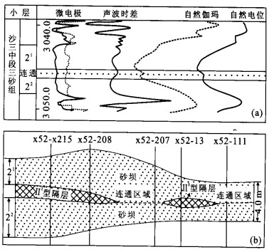
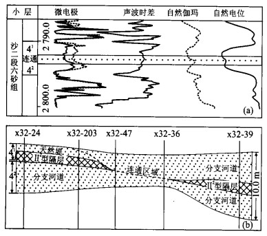
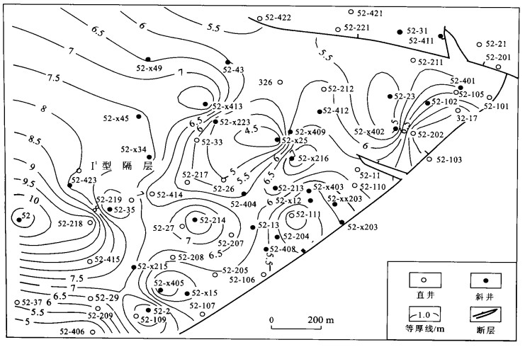
Based on detailed division and correlation of reservoir sandstones in Linnan oilfield, the insulating layers are systemically studied through core observation and well logging analysis.According to lithology and lithofacies of the layers, they are divided into mudstone insulating layers(typeⅠ), siltstone ones(typeⅡ)and carbonate-bearing ones(typeⅢ). Because of facies variation, typeⅠ insulating layers are subdivided intoⅠ1 andⅠ2, and typeⅡ intoⅡ1 andⅡ2.All the insulating layers have differentwell logging features, sedimentary assemblages and spatial distributions. Discontinuity of the insulating layers could make nearby sand layers connected.The connection between sandbarbodies or channel sand ones shows differentorigins and distinguishedwell loggingmodels.The spatial distribution characteristics of each insulating layer are concluded by the research of more than 110 well loggings, thus providing basic data for the prediction of residual oil and selection of exploitation methods.
Based on detailed division and correlation of reservoir sandstones in Linnan oilfield, the insulating layers are systemically studied through core observation and well logging analysis.According to lithology and lithofacies of the layers, they are divided into mudstone insulating layers(typeⅠ), siltstone ones(typeⅡ)and carbonate-bearing ones(typeⅢ). Because of facies variation, typeⅠ insulating layers are subdivided intoⅠ1 andⅠ2, and typeⅡ intoⅡ1 andⅡ2.All the insulating layers have differentwell logging features, sedimentary assemblages and spatial distributions. Discontinuity of the insulating layers could make nearby sand layers connected.The connection between sandbarbodies or channel sand ones shows differentorigins and distinguishedwell loggingmodels.The spatial distribution characteristics of each insulating layer are concluded by the research of more than 110 well loggings, thus providing basic data for the prediction of residual oil and selection of exploitation methods.


2004, 29(2): 219-223.
Abstract:
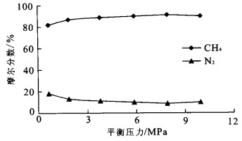
The adsorption isotherm experiments of CH4-CO2 and CH4-N2 binary-component gas were carried out respectively, and the variation regularity of each component concentration in the experiments were analyzed. The experiment results indicate that the relative concentration of CH4 component in absorbed phase increases gradually while the relative concentration of N2 component in absorbed phase decreases gradually in the adsorption isotherm experiment of CH4-N2 binary-component gas. Whereas the relative concentration of CO2 component in absorbed phase shows a gradual increase and the relative concentration of CH4 component shows a gradual decrease in the adsorption isotherm experiment of CO2-CH4 binary-component gas. These results confirm that CO2 occupies the predominant position and N2 locates at inferior position as they compete for adsorption with CH4 respectively. Therefore, CO2-injection can replace or displace coalbed methane and enhance methane recovery more effectively than N2-injection.
The adsorption isotherm experiments of CH4-CO2 and CH4-N2 binary-component gas were carried out respectively, and the variation regularity of each component concentration in the experiments were analyzed. The experiment results indicate that the relative concentration of CH4 component in absorbed phase increases gradually while the relative concentration of N2 component in absorbed phase decreases gradually in the adsorption isotherm experiment of CH4-N2 binary-component gas. Whereas the relative concentration of CO2 component in absorbed phase shows a gradual increase and the relative concentration of CH4 component shows a gradual decrease in the adsorption isotherm experiment of CO2-CH4 binary-component gas. These results confirm that CO2 occupies the predominant position and N2 locates at inferior position as they compete for adsorption with CH4 respectively. Therefore, CO2-injection can replace or displace coalbed methane and enhance methane recovery more effectively than N2-injection.


2004, 29(2): 224-230.
Abstract:
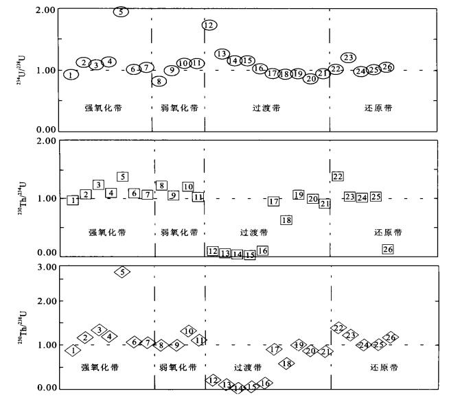
Uranium series disequilibrium techniques were used to provide information on the redox zoning and ore-forming processes of the Kujie'ertai uranium deposit, Yili basin, Xinjiang, NW China. The uranium and thorium contents and the activity ratios of 234U/238U, 230Th/234U and 230Th/238U for about 26 samples from the deposit were measured using ICP-MS and α-spectrometer respectively. The characteristics of uranium and thorium isotopes for different redox zones are significantly different, which can serve as indicators for locating ore-bodies of the sandstone-type uranium deposit. The U and Th concentrations and Th/U ratios of rocks are 12.4 μg/g, 4.5 μg/g and 0.48 for the strongly oxidized zone, 20.4 μg/g, (5.0 μg/g) and 0.38 for the weakly oxidized zone, 169.7 μg/g, 4.7 μg/g and 0.07 for the transitional zone (the mineralized zone), 6.8 μg/g, 3.7 μg/g and 0.87 for the reduced zone (the unaltered zone) respectively. These different redox zones also present different ratios of radioactive nuclides for various samples. The 234U/238U ratios are mostly greater than 1 for the strongly oxidized zone, partly greater or less than 1 and partly close to 1 for the redox front (the mineralized zone), and predominantly greater than unity for the reduced zone (the unaltered zone) respectively. While the ratios of 230Th/234U and 230Th/238U are greater than or close to unity for the oxidized zone, partly greater than 1 and partly less than or close to 1 for the redox front (the mineralized zone), and greater than or close to unity for the reduced zone (the mineralized zone). The uranium ore-formation processes in the deposit are traced effectively by U series disequilibrium.
Uranium series disequilibrium techniques were used to provide information on the redox zoning and ore-forming processes of the Kujie'ertai uranium deposit, Yili basin, Xinjiang, NW China. The uranium and thorium contents and the activity ratios of 234U/238U, 230Th/234U and 230Th/238U for about 26 samples from the deposit were measured using ICP-MS and α-spectrometer respectively. The characteristics of uranium and thorium isotopes for different redox zones are significantly different, which can serve as indicators for locating ore-bodies of the sandstone-type uranium deposit. The U and Th concentrations and Th/U ratios of rocks are 12.4 μg/g, 4.5 μg/g and 0.48 for the strongly oxidized zone, 20.4 μg/g, (5.0 μg/g) and 0.38 for the weakly oxidized zone, 169.7 μg/g, 4.7 μg/g and 0.07 for the transitional zone (the mineralized zone), 6.8 μg/g, 3.7 μg/g and 0.87 for the reduced zone (the unaltered zone) respectively. These different redox zones also present different ratios of radioactive nuclides for various samples. The 234U/238U ratios are mostly greater than 1 for the strongly oxidized zone, partly greater or less than 1 and partly close to 1 for the redox front (the mineralized zone), and predominantly greater than unity for the reduced zone (the unaltered zone) respectively. While the ratios of 230Th/234U and 230Th/238U are greater than or close to unity for the oxidized zone, partly greater than 1 and partly less than or close to 1 for the redox front (the mineralized zone), and greater than or close to unity for the reduced zone (the mineralized zone). The uranium ore-formation processes in the deposit are traced effectively by U series disequilibrium.


2004, 29(2): 231-234.
Abstract:
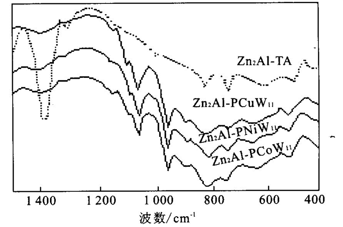
Hydrotalcite-like compounds, heteropolyanions with different compositions, and their pillared products were synthesized by coprecipitation. The structures were characterized by XRD and IR with Keggin structure. The results indicated that these materials possess exceptionally well-ordered gallery height of 0.97 nm. It is found that this kind of pillared layered catalyst has high activity and selectivity for the oxidation of benzaldehyde to benzoic acid using H2O2 as oxidant in liquid-solid phase system.
Hydrotalcite-like compounds, heteropolyanions with different compositions, and their pillared products were synthesized by coprecipitation. The structures were characterized by XRD and IR with Keggin structure. The results indicated that these materials possess exceptionally well-ordered gallery height of 0.97 nm. It is found that this kind of pillared layered catalyst has high activity and selectivity for the oxidation of benzaldehyde to benzoic acid using H2O2 as oxidant in liquid-solid phase system.


2004, 29(2): 235-238.
Abstract:
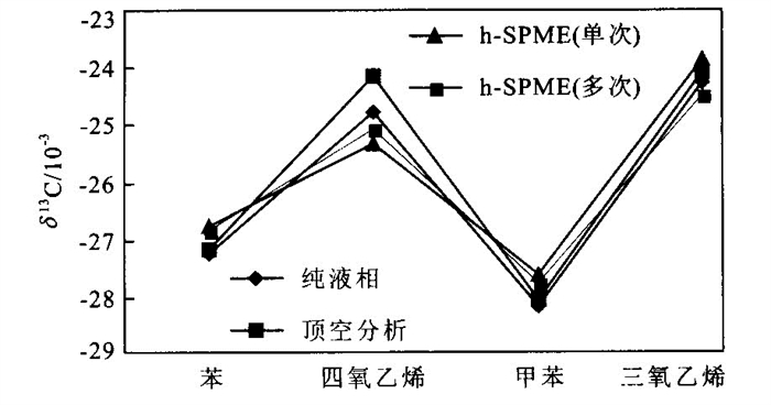
Compound-specific carbon isotope ration analysis is a promising tool to assess the origin and fate of organic contaminants, however, the low concentrations of dissolved organic pollutants and the difficulty to concentrate or extract have been the major facts limiting the application of stable isotope tracing techniques at contaminated field sites. In this paper, we developed a method combining SPME with cryofocus technique for the compound-specific carbon isotope analysis of volatile organic compounds in aqueous phase, samples were extracted with SPME and then cryofocus to the front part of GC column, the samples were cumulated after several times of extraction and meet the detection limit. The detection limit using this method was 10 times improved than the conventional SPME method. Under the optimum analytical condition, aqueous samples Trichloroethene, Tetrachloroethene, Benzene and Toluene were analyzed, δ13C fractionation compared to pure-phase analysis was less than 0.5×10⁻³, the reproducibility was better than ±0.3×10⁻³. GC-IRMS coupling with SPME and Cryofocus technique proved to be a promising and accurate method for the determination of carbon isotope composition of trace-level volatile organic compounds in aqueous phases.
Compound-specific carbon isotope ration analysis is a promising tool to assess the origin and fate of organic contaminants, however, the low concentrations of dissolved organic pollutants and the difficulty to concentrate or extract have been the major facts limiting the application of stable isotope tracing techniques at contaminated field sites. In this paper, we developed a method combining SPME with cryofocus technique for the compound-specific carbon isotope analysis of volatile organic compounds in aqueous phase, samples were extracted with SPME and then cryofocus to the front part of GC column, the samples were cumulated after several times of extraction and meet the detection limit. The detection limit using this method was 10 times improved than the conventional SPME method. Under the optimum analytical condition, aqueous samples Trichloroethene, Tetrachloroethene, Benzene and Toluene were analyzed, δ13C fractionation compared to pure-phase analysis was less than 0.5×10⁻³, the reproducibility was better than ±0.3×10⁻³. GC-IRMS coupling with SPME and Cryofocus technique proved to be a promising and accurate method for the determination of carbon isotope composition of trace-level volatile organic compounds in aqueous phases.


2004, 29(2): 239-246.
Abstract:
Plant below-ground habitat is an important part of the plant habitat, and the systemic analysis of its structure should be emphasized in seeking for the regulations of the ecological relationship between plant and its habitat. Remarkable characteristics of the dissipative structure are discovered in the plant below-ground habitat, made up of many layers displaying macroscopic stability as a result of the self-organization. This layered structure of the plant below-ground habitat is well consistent with the synusium of the root masses. This synusium allows us to predict that each layer means one special below-ground little living environment for the root mass of the plant species, and if the below-ground habitat is made up of many such layers, it would provide various little below-ground living environments for different plant species. In the analysis, the root mass of the plant, defined as the part of the roots performing the major function of absorbing soil resources, is the linchpin between the plant and its below-ground habitat. Compared with the root system, the synusium of the root masses (among) different plants is clearer, by which, different plants can partition the resources in different deep layers to avoid intensive competition and coexist for long term. Based on the analysis of the dissipative structure of plant below-ground habitat and statistical results about the depth of the species root mass, the concept "stable layer of plant species in below-ground habitat" (SLPSBH) is built, which can be determined by the position of the root mass and used as the basic unit for layering the plant below-ground habitat in view of its ecological function. With the concept, we may predict that (1) the configuration of physical and chemical indexes in the stable layer can characterize the below-ground living environment of the plant more truly than the averages of the indexes in whole soil profile, (2) some life habits and physiological characteristics of the plant species is built on long-term adapt to the value and dynamic of the configuration in its stable layer, (3) it may be how many SLPSBH can be provided in below-ground habitat for different plant species that determines the structural features of the plant community, and (4) the plant species which SLPSBH exists no longer would disappear from the community, while the new comers may invade for they can find their SLPSBH, leading to the succession of the plant community.
Plant below-ground habitat is an important part of the plant habitat, and the systemic analysis of its structure should be emphasized in seeking for the regulations of the ecological relationship between plant and its habitat. Remarkable characteristics of the dissipative structure are discovered in the plant below-ground habitat, made up of many layers displaying macroscopic stability as a result of the self-organization. This layered structure of the plant below-ground habitat is well consistent with the synusium of the root masses. This synusium allows us to predict that each layer means one special below-ground little living environment for the root mass of the plant species, and if the below-ground habitat is made up of many such layers, it would provide various little below-ground living environments for different plant species. In the analysis, the root mass of the plant, defined as the part of the roots performing the major function of absorbing soil resources, is the linchpin between the plant and its below-ground habitat. Compared with the root system, the synusium of the root masses (among) different plants is clearer, by which, different plants can partition the resources in different deep layers to avoid intensive competition and coexist for long term. Based on the analysis of the dissipative structure of plant below-ground habitat and statistical results about the depth of the species root mass, the concept "stable layer of plant species in below-ground habitat" (SLPSBH) is built, which can be determined by the position of the root mass and used as the basic unit for layering the plant below-ground habitat in view of its ecological function. With the concept, we may predict that (1) the configuration of physical and chemical indexes in the stable layer can characterize the below-ground living environment of the plant more truly than the averages of the indexes in whole soil profile, (2) some life habits and physiological characteristics of the plant species is built on long-term adapt to the value and dynamic of the configuration in its stable layer, (3) it may be how many SLPSBH can be provided in below-ground habitat for different plant species that determines the structural features of the plant community, and (4) the plant species which SLPSBH exists no longer would disappear from the community, while the new comers may invade for they can find their SLPSBH, leading to the succession of the plant community.
2004, 29(2): 247-252.
Abstract:
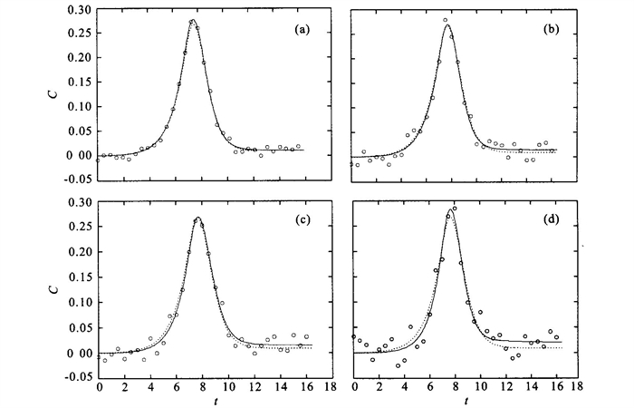
Taken the parameter inversion of solute transport through unsaturated soils as the application background and homotopy method imported for solving the nonlinear parameter inversion problem, this paper presents a global convergence method, HISR (homotopy Itakura-Saito regularization) method. The Itakura-Saito distance between the iterative parameter value and the estimated parameter value was adopted as the trivial problem in the homotopy function based on the idea of regularization. Moreover, a continuous method is employed to modify the homotopy parameter during iteration in order to ensure the ability of the iteration and the capability of the noise resistance. Problems of parameter inversion of solute transport coupled with equilibrium and non-equilibrium effects through one-dimensional unsaturated soils are carried out as numerical examples, and the computational results clearly demonstrated the features of global convergence and stability of the HISR method. Besides, a favorable solution is obtained even though experimental quantities were contaminated heavily by noise by HISR method.
Taken the parameter inversion of solute transport through unsaturated soils as the application background and homotopy method imported for solving the nonlinear parameter inversion problem, this paper presents a global convergence method, HISR (homotopy Itakura-Saito regularization) method. The Itakura-Saito distance between the iterative parameter value and the estimated parameter value was adopted as the trivial problem in the homotopy function based on the idea of regularization. Moreover, a continuous method is employed to modify the homotopy parameter during iteration in order to ensure the ability of the iteration and the capability of the noise resistance. Problems of parameter inversion of solute transport coupled with equilibrium and non-equilibrium effects through one-dimensional unsaturated soils are carried out as numerical examples, and the computational results clearly demonstrated the features of global convergence and stability of the HISR method. Besides, a favorable solution is obtained even though experimental quantities were contaminated heavily by noise by HISR method.