2004 Vol. 29, No. 3
Display Method:
2004, 29(3): 253-262.
 PDF 696KB
Abstract:
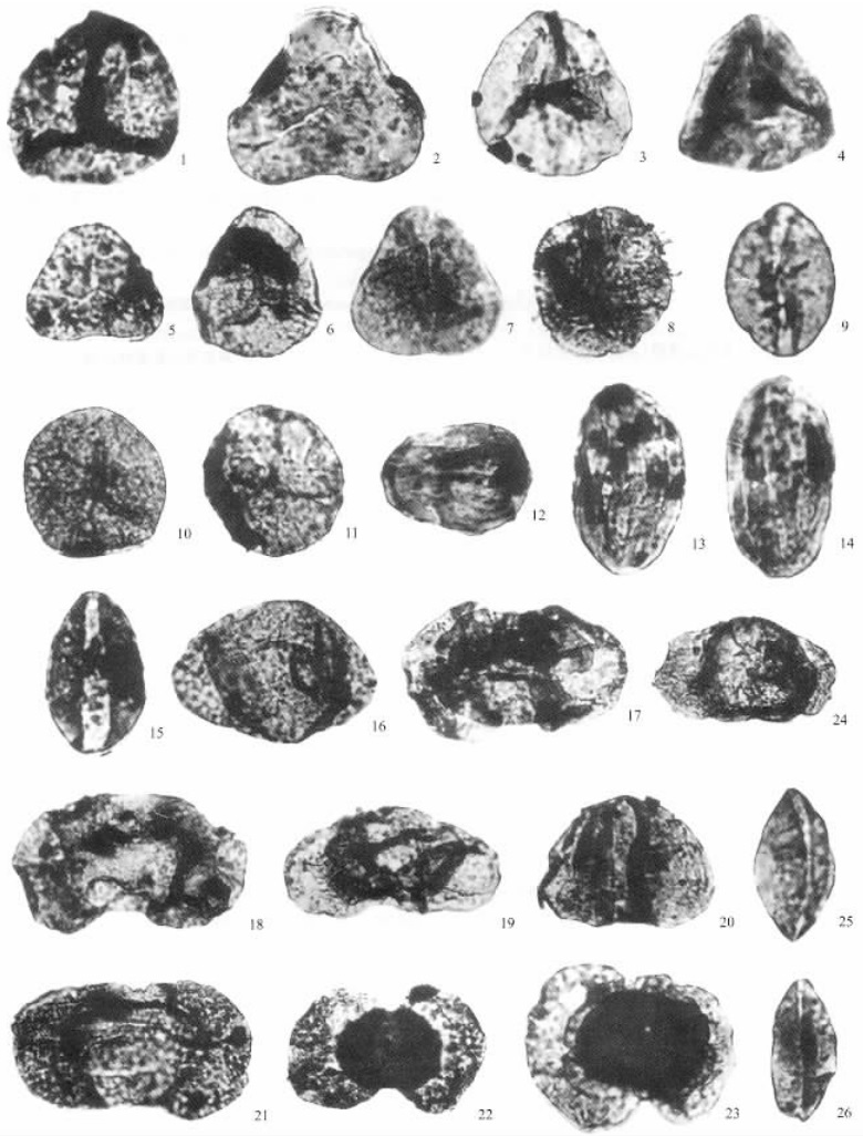
Altogether 47 genera and 50 species were identified in 12 of all the 89 samples taken within 14 m Yinkeng Formation (Bed 25-60) in Meishan Section D (GSSP) of Changxing in Zhejiang. The palynological assemblage is Lundbladispora-Taeniaesporites-Equisetosporites with the dominance (59.0%-79.6%) of gymnosperm pollen and secondary (20.4%-40.0%) of fern spore. The gymnosperm pollen was dominated by the instriate bisaccate (19.7%-54.4%) characterized by the greatest diversity and abundance of coniferousbisaccate pollen. The striate bisaccate pollen is secondary and the polyclicate pollen composed of only one genus Equisetosporites has an abundance up to 24.3%. The fern spore was dominantly represented by Liotriletes (14.3%-24.4%) with the predominance of the cycloid Puncatisporites (16.2%). The secondary are the echinate, granular and verrucose trilete spores (1.9%-21.2%). The fastigiate trilete spore has a relatively low quantity but spreads wide, mainly Lundbladispora. Zonotrilete spore is quite rare. Significantly, this palynological assemblage in Section D of Meishan, correlative with the conodont Isarcicella isarcica Zone and the Clarkina carinata-C. planate Zone, is comparable with palynological assemblages observed in other sections in South China but incompatible with those in North China. This discrimination suggests the earlier evolution of Mesozoic palynological assemblage in North China than in South China.
Altogether 47 genera and 50 species were identified in 12 of all the 89 samples taken within 14 m Yinkeng Formation (Bed 25-60) in Meishan Section D (GSSP) of Changxing in Zhejiang. The palynological assemblage is Lundbladispora-Taeniaesporites-Equisetosporites with the dominance (59.0%-79.6%) of gymnosperm pollen and secondary (20.4%-40.0%) of fern spore. The gymnosperm pollen was dominated by the instriate bisaccate (19.7%-54.4%) characterized by the greatest diversity and abundance of coniferousbisaccate pollen. The striate bisaccate pollen is secondary and the polyclicate pollen composed of only one genus Equisetosporites has an abundance up to 24.3%. The fern spore was dominantly represented by Liotriletes (14.3%-24.4%) with the predominance of the cycloid Puncatisporites (16.2%). The secondary are the echinate, granular and verrucose trilete spores (1.9%-21.2%). The fastigiate trilete spore has a relatively low quantity but spreads wide, mainly Lundbladispora. Zonotrilete spore is quite rare. Significantly, this palynological assemblage in Section D of Meishan, correlative with the conodont Isarcicella isarcica Zone and the Clarkina carinata-C. planate Zone, is comparable with palynological assemblages observed in other sections in South China but incompatible with those in North China. This discrimination suggests the earlier evolution of Mesozoic palynological assemblage in North China than in South China.
2004, 29(3): 263-268.
Abstract:
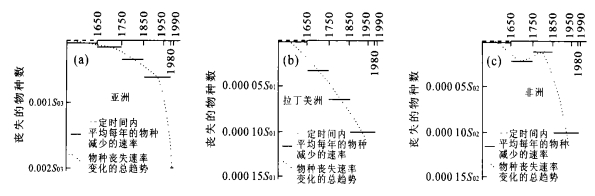
Since the 18th century the earth environment was extremely destroyed by anthropogenic activity, associated with the sharp decrease of biodiversity. In order to understand the trend of biodiversity variation, authors compare the biodiversity variation within recent 400 years with the biotic crisis occurring at the transitional period of Paleozoic-Mesozoic. Current biodiversity, evaluated by means of 'statistic of extinction species' and 'species-area curve', is characterized by a high species extinction rate ranging from 8×10⁴ species to 1.2×10⁶ species per million year, but nearly by zero of genus extinction. Similarly, the initial phase of the Paleozoic-Mesozoic mass extinction, calculated from the previously reported fossil records, was also distinguishable by a high species extinction rate ranging from 40 to 150 species per million year and a low extinction rate of genus, 66 genera per million year, which is far less than 465 genera per million year representative of the peak phase of Permian-Triassic mass extinction. Modern biodiversity variation is thus comparable with the initial phase of the Permian-Triassic mass extinction.
Since the 18th century the earth environment was extremely destroyed by anthropogenic activity, associated with the sharp decrease of biodiversity. In order to understand the trend of biodiversity variation, authors compare the biodiversity variation within recent 400 years with the biotic crisis occurring at the transitional period of Paleozoic-Mesozoic. Current biodiversity, evaluated by means of 'statistic of extinction species' and 'species-area curve', is characterized by a high species extinction rate ranging from 8×10⁴ species to 1.2×10⁶ species per million year, but nearly by zero of genus extinction. Similarly, the initial phase of the Paleozoic-Mesozoic mass extinction, calculated from the previously reported fossil records, was also distinguishable by a high species extinction rate ranging from 40 to 150 species per million year and a low extinction rate of genus, 66 genera per million year, which is far less than 465 genera per million year representative of the peak phase of Permian-Triassic mass extinction. Modern biodiversity variation is thus comparable with the initial phase of the Permian-Triassic mass extinction.


2004, 29(3): 269-277.
Abstract:
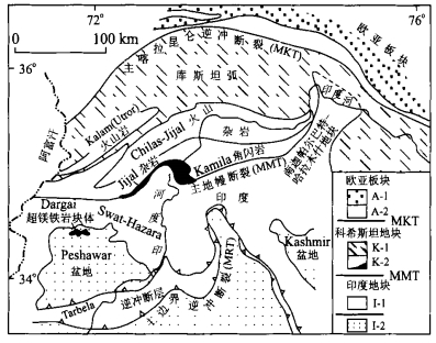
There are two syntaxes, where orogenic structures turn sharply. They occurred in the eastern and western ends of the Himalayan belt respectively, and are the ideal places to discuss the evolution of the belt. The comparison of geological data from the eastern and the western syntaxes shows that they have: (1) similar geography, (2) similar geological features and evolution (both lost the Himalayan sediments of Cambrian-Tertiary), (3) similar high-pressure metamorphic rocks overprinted by the re-melting of crust and migmatization younger than 10 Ma, (4) similar rapid uplifting experience since 25 Ma, especially since 10 Ma, (5) similar ages of the collision between India and Eurasia (75 Ma and 65 Ma in eastern and western syntaxes respectively) and much earlier than other places within the belt. The similarities suggest that: (1) detachment and surface processes (especially river process) would be the main reasons resulting in rapid denudation, and (2) the melts derived from the partial melting rocks in middle to low crust due to the denudation flowed and focused would play important roles on the evolutions of the syntaxes.
There are two syntaxes, where orogenic structures turn sharply. They occurred in the eastern and western ends of the Himalayan belt respectively, and are the ideal places to discuss the evolution of the belt. The comparison of geological data from the eastern and the western syntaxes shows that they have: (1) similar geography, (2) similar geological features and evolution (both lost the Himalayan sediments of Cambrian-Tertiary), (3) similar high-pressure metamorphic rocks overprinted by the re-melting of crust and migmatization younger than 10 Ma, (4) similar rapid uplifting experience since 25 Ma, especially since 10 Ma, (5) similar ages of the collision between India and Eurasia (75 Ma and 65 Ma in eastern and western syntaxes respectively) and much earlier than other places within the belt. The similarities suggest that: (1) detachment and surface processes (especially river process) would be the main reasons resulting in rapid denudation, and (2) the melts derived from the partial melting rocks in middle to low crust due to the denudation flowed and focused would play important roles on the evolutions of the syntaxes.


2004, 29(3): 278-282.
Abstract:
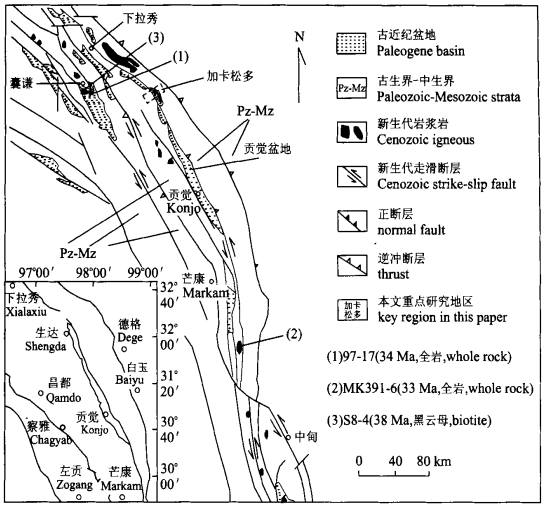
Based on the isotopic chronologic results of Cenozoic volcanic rocks from Gongjue basin in eastern Tibet, the uplifting of the Tibetan plateau was studied. The K-Ar diluted ages of seven volcanic rocks from the Gongjue basin in eastern Tibet are firstly reported. Apparent ages of the whole rock and their biotite are 40.8 to 46.2 Ma with an average of 44.2 Ma. Radiogenic Ar and K of the samples compose an isochron line with high correlation coefficient, which almost passes through the origin. The result indicates that there is neither residual Ar nor loss of radiogenic Ar in these samples. Therefore, they give the eruption ages of the volcanic rocks (i.e. middle Eocene). The volcanic activities in the studied region occurred in the post-collision tectonic setting of Indian-Eurasia plate collision (about 50 Ma) and were controlled by intra-continental horizontal shear faults. Evidences including the published data show that the Cenozoic volcanic activities in eastern Tibet vary greatly. The variety can be considered as the product of the crust-mantle interaction due to the multi-stage uplift in the (Tibetan) plateau.
Based on the isotopic chronologic results of Cenozoic volcanic rocks from Gongjue basin in eastern Tibet, the uplifting of the Tibetan plateau was studied. The K-Ar diluted ages of seven volcanic rocks from the Gongjue basin in eastern Tibet are firstly reported. Apparent ages of the whole rock and their biotite are 40.8 to 46.2 Ma with an average of 44.2 Ma. Radiogenic Ar and K of the samples compose an isochron line with high correlation coefficient, which almost passes through the origin. The result indicates that there is neither residual Ar nor loss of radiogenic Ar in these samples. Therefore, they give the eruption ages of the volcanic rocks (i.e. middle Eocene). The volcanic activities in the studied region occurred in the post-collision tectonic setting of Indian-Eurasia plate collision (about 50 Ma) and were controlled by intra-continental horizontal shear faults. Evidences including the published data show that the Cenozoic volcanic activities in eastern Tibet vary greatly. The variety can be considered as the product of the crust-mantle interaction due to the multi-stage uplift in the (Tibetan) plateau.

2004, 29(3): 283-292.
Abstract:
The dynamic mechanisms of the formation of the Songliao and the Bohaiwan basins, eastern China, are controversial. Based on the analyses of earthquake data, sedimentary record, volcanic probe and tectonic evolution, it is argued that the activity of mantle plume firstly undertook at the region around the Songhuajiang and the Liaohe rivers during Late Jurassic and Early Cretaceous time. The plume head was of 500 km in diameter at this stage. The Songliao basin formed due to the asthenospheric upwelling, crustal uplift and subsequent extension, and volcanic activity. However, the mantle plume, with 600-800 km head in diameter, would be beneath the Bohaiwan area in the Paleocene due to northwestward movement of the North China plate. The similar geological processes to the last stage undertook, and resulted in the formation of the Bohaiwan basin. Meanwhile, the plume is interpreted as the major factor of frequent earthquake at the Beijing-Tianjin and Bohaiwan area.
The dynamic mechanisms of the formation of the Songliao and the Bohaiwan basins, eastern China, are controversial. Based on the analyses of earthquake data, sedimentary record, volcanic probe and tectonic evolution, it is argued that the activity of mantle plume firstly undertook at the region around the Songhuajiang and the Liaohe rivers during Late Jurassic and Early Cretaceous time. The plume head was of 500 km in diameter at this stage. The Songliao basin formed due to the asthenospheric upwelling, crustal uplift and subsequent extension, and volcanic activity. However, the mantle plume, with 600-800 km head in diameter, would be beneath the Bohaiwan area in the Paleocene due to northwestward movement of the North China plate. The similar geological processes to the last stage undertook, and resulted in the formation of the Bohaiwan basin. Meanwhile, the plume is interpreted as the major factor of frequent earthquake at the Beijing-Tianjin and Bohaiwan area.


2004, 29(3): 293-302.
Abstract:
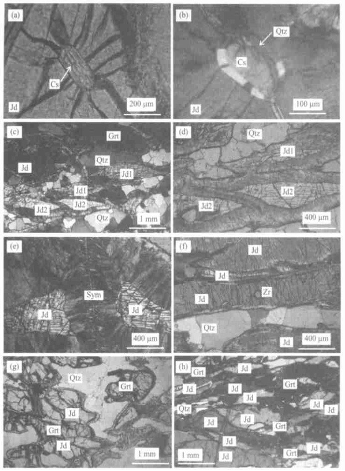
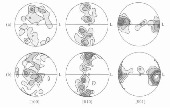
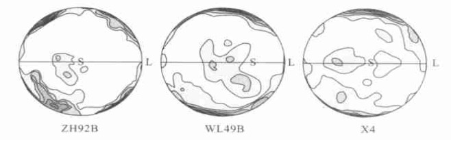
Jadeite-quartzite of Dabie Mountains is one of the important rock types occurring in ultrahigh-pressure (UHP) metamorphic belts. It is significant to study the jadeite-quartzite's deformation mechanisms and geodynamical parameters (such as stress, strain, strain rate) for the knowledge on the formation and evolution of the Dabie-Sulu ultrahigh-pressure (UHP) metamorphic belts. Three representative samples of the Shuanghe jadeite-quartzite from Dabie UHP belt were undertook by the microfabric and TEM for lattice preferred orientation (LPO). The results show that the LPOs of jadeite are similar to those of omphacite. Their LPOs are L- and LS-type. However, the LPOs of quartze are monoclinic symmetry type. The slip systems of jadeite are mainly (100), (110) and (110) 1/2. Abundant dislocations develop in quartz, which is of dominant slip system of (0001) -derived from basal glide. The slip system represented regional shearing durin g the exhumation of the UHP belt.
Jadeite-quartzite of Dabie Mountains is one of the important rock types occurring in ultrahigh-pressure (UHP) metamorphic belts. It is significant to study the jadeite-quartzite's deformation mechanisms and geodynamical parameters (such as stress, strain, strain rate) for the knowledge on the formation and evolution of the Dabie-Sulu ultrahigh-pressure (UHP) metamorphic belts. Three representative samples of the Shuanghe jadeite-quartzite from Dabie UHP belt were undertook by the microfabric and TEM for lattice preferred orientation (LPO). The results show that the LPOs of jadeite are similar to those of omphacite. Their LPOs are L- and LS-type. However, the LPOs of quartze are monoclinic symmetry type. The slip systems of jadeite are mainly (100), (110) and (110) 1/2. Abundant dislocations develop in quartz, which is of dominant slip system of (0001) -derived from basal glide. The slip system represented regional shearing durin g the exhumation of the UHP belt.


2004, 29(3): 303-308.
Abstract:
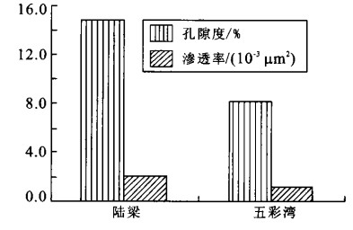
The researches on oil- and gas-bearing volcanic rocks have largely developed the foreground of oil exploration. Types, facies distribution and physical properties (mainly porosity and permeability) of volcanic rock of the basement beneath the Wucaiwan depression, the eastern part of Junggar basin, are studied, based on the data of petrography and FMI. Oil- and gas-bearing volcanic rocks in this area belong to the Bashan group (C2b). The rocks are mainly lava (including andesites and basalts) and pyroclastic ones. The average porosity and permeability are 7.42% and 0.82×10⁻³ μm2 in lavas, and are 9.84% and 0.33×10⁻³ μm2 in volcanic breccias respectively. The reservoir-spaces of the rocks are mainly composed of secondary pores and fissures. The reservoir property in the Wucaiwan area is slightly poorer than that of the basement beneath the Shixi oilfield, the center part of the basin, where there is the best reservoir property in volcanic rocks. The environment during the volcanic eruption, types and facies of the rocks, and subsequent modification play important roles on the reservoir properties of the basement rocks.
The researches on oil- and gas-bearing volcanic rocks have largely developed the foreground of oil exploration. Types, facies distribution and physical properties (mainly porosity and permeability) of volcanic rock of the basement beneath the Wucaiwan depression, the eastern part of Junggar basin, are studied, based on the data of petrography and FMI. Oil- and gas-bearing volcanic rocks in this area belong to the Bashan group (C2b). The rocks are mainly lava (including andesites and basalts) and pyroclastic ones. The average porosity and permeability are 7.42% and 0.82×10⁻³ μm2 in lavas, and are 9.84% and 0.33×10⁻³ μm2 in volcanic breccias respectively. The reservoir-spaces of the rocks are mainly composed of secondary pores and fissures. The reservoir property in the Wucaiwan area is slightly poorer than that of the basement beneath the Shixi oilfield, the center part of the basin, where there is the best reservoir property in volcanic rocks. The environment during the volcanic eruption, types and facies of the rocks, and subsequent modification play important roles on the reservoir properties of the basement rocks.


2004, 29(3): 309-316.
Abstract:
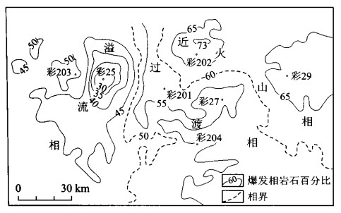
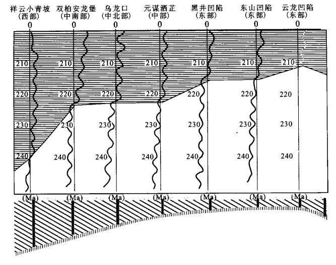
Chuxiong basin is a Mesozoic-Cenozoic petroleum basin in the southwestern margin of the Yangtze plate, which has a complex tectonic and sedimentation history. By using the analysis method of wave processes, major evolution cycles of the Chuxiong basin have been studied. This study shows that there are three first-order sedimentary cycles (220 Ma), six second-order sedimentary cycles (100 Ma), nine and a half third-order sedimentary cycles (45 Ma) and high-frequency cycles (10 Ma, 5 Ma). By comparison of the wave curves in different wave units, we gained the tectonic-sedimentation regularity: the sedimentation center in Paleozoic was in the Yunlong Depression in the eastern part of the basin. Early in the Mesozoic, the sedimentation center migrated from southwest to northeast and from basin margin to basin center. In late Mesozoic, the sedimentation center displayed a reversed migration trend from northeast to southwest.
Chuxiong basin is a Mesozoic-Cenozoic petroleum basin in the southwestern margin of the Yangtze plate, which has a complex tectonic and sedimentation history. By using the analysis method of wave processes, major evolution cycles of the Chuxiong basin have been studied. This study shows that there are three first-order sedimentary cycles (220 Ma), six second-order sedimentary cycles (100 Ma), nine and a half third-order sedimentary cycles (45 Ma) and high-frequency cycles (10 Ma, 5 Ma). By comparison of the wave curves in different wave units, we gained the tectonic-sedimentation regularity: the sedimentation center in Paleozoic was in the Yunlong Depression in the eastern part of the basin. Early in the Mesozoic, the sedimentation center migrated from southwest to northeast and from basin margin to basin center. In late Mesozoic, the sedimentation center displayed a reversed migration trend from northeast to southwest.


2004, 29(3): 317-322.
Abstract:
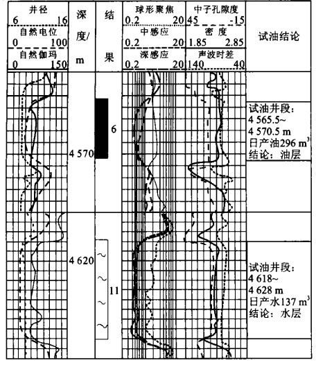
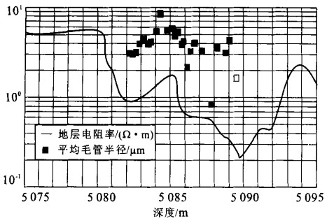
As petroleum exploration continues, a series of low-resistivity oil reservoirs have been found in the Tarim basin. The lowest resistivity of the oil reservoir is only 0.45 Ω·m, almost identical to the resistivity of water layer. Geological observations and experimental analyses on the Jurassic (JⅣ) low-resistivity oil reservoir in Lunnan, Triassic (TⅡ) low-resistivity oil reservoir in Jilake and Carboniferous (CⅢ) low-resistivity oil reservoir in Hadexun indicate that the main causes of the low resistivity of the oil reservoirs are the local enrichment of pyrite and the additional electricity conducting effect of clay minerals and the low salinity bound water. Several evaluation methods using different data such as capillary pressure, oil saturation and rock electrical parameters under high temperature and high pressure conditions are presented. Using these methods, the calculated oil saturation increases by 8% to 25%, and the accuracy of well logging explanation increases by 5% to 8%.
As petroleum exploration continues, a series of low-resistivity oil reservoirs have been found in the Tarim basin. The lowest resistivity of the oil reservoir is only 0.45 Ω·m, almost identical to the resistivity of water layer. Geological observations and experimental analyses on the Jurassic (JⅣ) low-resistivity oil reservoir in Lunnan, Triassic (TⅡ) low-resistivity oil reservoir in Jilake and Carboniferous (CⅢ) low-resistivity oil reservoir in Hadexun indicate that the main causes of the low resistivity of the oil reservoirs are the local enrichment of pyrite and the additional electricity conducting effect of clay minerals and the low salinity bound water. Several evaluation methods using different data such as capillary pressure, oil saturation and rock electrical parameters under high temperature and high pressure conditions are presented. Using these methods, the calculated oil saturation increases by 8% to 25%, and the accuracy of well logging explanation increases by 5% to 8%.


2004, 29(3): 323-326.
Abstract:
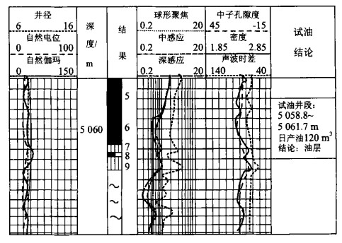
Outcrop oil reservoir is a special reservoir controlled by water table. Theoretical analyses and detailed studies of the Qiketai oilfield in the Tuha basin showed that the outcrop oil reservoirs were formed in basins with deeply-buried water table, rich source of oil and outcrop traps. There were two entrapment models for the outcrop reservoirs. One model was that outcrop reservoirs developed in the wing of an outcrop anticline. The other model was that the outcrop reservoir occurred in the monocline that was laterally sealed by lithology. The outcrop reservoirs were usually characterized by small burial depth (tens to hundreds of meters), late accumulation and usually good reservoir porosity and permeability (the porosity was usually higher than 15%).
Outcrop oil reservoir is a special reservoir controlled by water table. Theoretical analyses and detailed studies of the Qiketai oilfield in the Tuha basin showed that the outcrop oil reservoirs were formed in basins with deeply-buried water table, rich source of oil and outcrop traps. There were two entrapment models for the outcrop reservoirs. One model was that outcrop reservoirs developed in the wing of an outcrop anticline. The other model was that the outcrop reservoir occurred in the monocline that was laterally sealed by lithology. The outcrop reservoirs were usually characterized by small burial depth (tens to hundreds of meters), late accumulation and usually good reservoir porosity and permeability (the porosity was usually higher than 15%).


2004, 29(3): 327-332.
Abstract:
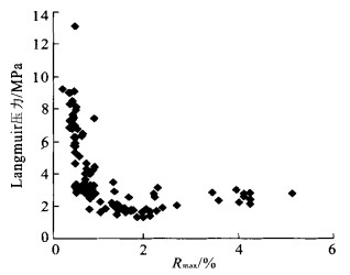
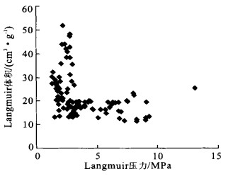
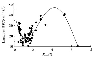
In order to research on the gas storage capacity of coal, a series of tests were carried out using 124 coal samples. These tests include: isothermal adsorption test, coal petrography analysis, proximate analysis, mercury intrusion test and cryogenic liquid nitrogen test. The research shows: (1) Coal metamorphism controls the adsorptive capacity. As R max increases from 0.3% to 4.25%, the volume of Langmuir increases from 11.25 to 47.16 cm3/g. (2) The capacity rate of the coal processed with equilibrium moisture has a normal correlation to the vitrinite content and an inverse correlation to the inertinite content of the coal, and displays a normal correlation to the specific surface areas of pore and micropore, and micropore volume. (3) The moisture and temperature have inverse influence on coal adsorptive capacity. Coals at different metamorphic stages have different variation tendency of adsorption curves. The adsorptive capacity of gas coal increases with temperature and pressure, indicating the dominant role of pressure. The adsorptive capacity of anthracite increases with increasing temperature and pressure when the temperature is lower than 60 ℃ and the pressure lower than 15 MPa, which also indicates the dominant role of pressure. When the temperature is over 60 ℃ and the pressure higher than 15 MPa, the adsorptive capacity of the anthracite decreases, suggesting that the influence of temperature is stronger than that of pressure.
In order to research on the gas storage capacity of coal, a series of tests were carried out using 124 coal samples. These tests include: isothermal adsorption test, coal petrography analysis, proximate analysis, mercury intrusion test and cryogenic liquid nitrogen test. The research shows: (1) Coal metamorphism controls the adsorptive capacity. As R max increases from 0.3% to 4.25%, the volume of Langmuir increases from 11.25 to 47.16 cm3/g. (2) The capacity rate of the coal processed with equilibrium moisture has a normal correlation to the vitrinite content and an inverse correlation to the inertinite content of the coal, and displays a normal correlation to the specific surface areas of pore and micropore, and micropore volume. (3) The moisture and temperature have inverse influence on coal adsorptive capacity. Coals at different metamorphic stages have different variation tendency of adsorption curves. The adsorptive capacity of gas coal increases with temperature and pressure, indicating the dominant role of pressure. The adsorptive capacity of anthracite increases with increasing temperature and pressure when the temperature is lower than 60 ℃ and the pressure lower than 15 MPa, which also indicates the dominant role of pressure. When the temperature is over 60 ℃ and the pressure higher than 15 MPa, the adsorptive capacity of the anthracite decreases, suggesting that the influence of temperature is stronger than that of pressure.


2004, 29(3): 333-339.
Abstract:
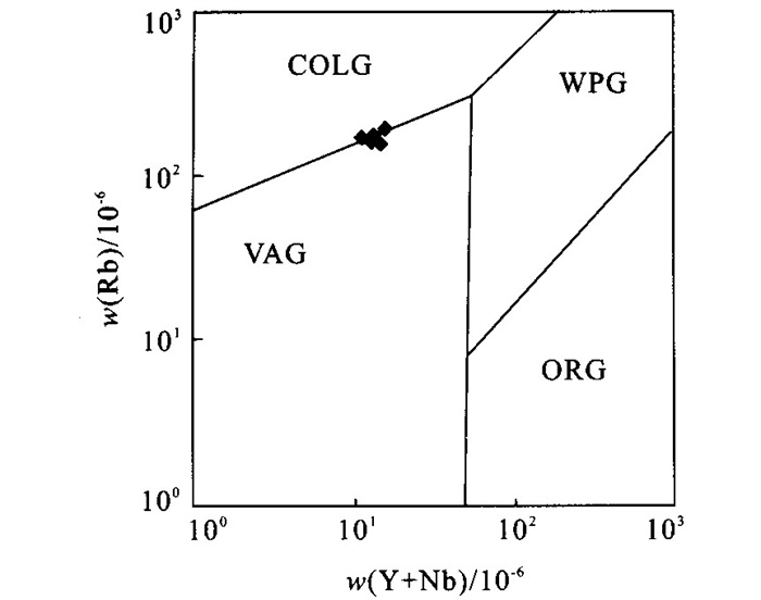
The Chongjiang copper deposit is a large porphyry copper (molybdenum, aurum) deposit found in Tibet in recent years. It is also the first one that has made great breakthrough during the process of looking for porphyry copper deposit in Gangdise orogenic belt. The deposit has the characters of circular and surfacing model in mineralization and alteration belt. Cu mineralization is according to K-Si alteration belt approximately.Methodssuch as ICPMS on the rocks with mineralization, Re-Os dating on molybdenite and U-Pb dating on zircon, were used in this research. The results show that the mineralizing porphyry enriches in K, Na, Al and light rare earth element (LREE) with high LREE/HREE (8.56-23.1). The porphyry is normal in Eu (δEu=1.001), but weak negative abnormal in Ce (δCe=0.84), and shows the characteristics of the transitional granite between type Ⅰ and type A. The characteristics reflect the magmatism related to asthenospheric upwelling. The Chongjiang porphyry copper (molybdenum, aurum) deposit formed in 14-16 Ma, the transitional period of extrusion and extension in orogenic belt.
The Chongjiang copper deposit is a large porphyry copper (molybdenum, aurum) deposit found in Tibet in recent years. It is also the first one that has made great breakthrough during the process of looking for porphyry copper deposit in Gangdise orogenic belt. The deposit has the characters of circular and surfacing model in mineralization and alteration belt. Cu mineralization is according to K-Si alteration belt approximately.Methodssuch as ICPMS on the rocks with mineralization, Re-Os dating on molybdenite and U-Pb dating on zircon, were used in this research. The results show that the mineralizing porphyry enriches in K, Na, Al and light rare earth element (LREE) with high LREE/HREE (8.56-23.1). The porphyry is normal in Eu (δEu=1.001), but weak negative abnormal in Ce (δCe=0.84), and shows the characteristics of the transitional granite between type Ⅰ and type A. The characteristics reflect the magmatism related to asthenospheric upwelling. The Chongjiang porphyry copper (molybdenum, aurum) deposit formed in 14-16 Ma, the transitional period of extrusion and extension in orogenic belt.


2004, 29(3): 340-346.
Abstract:
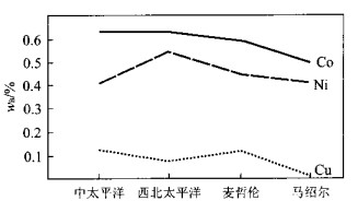
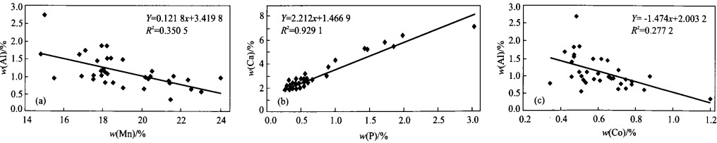
Multi-metallic crust from seamount is one kind of oceanic mineral resources with the most perspective exploitation. More than forty samples of the multi-metallic crust from six seamounts in the middle Pacific Ocean were analyzed by X-ray fluorescence and ICP-AES. Combining with the published data, the constituent variety and the elemental relationships are discussed under the consideration of the depth and topography of the crust derivation. The results show that the contents of the main ore-forming constituents in the samples from the middle Pacific Ocean are similar to those from the northwest Pacific Ocean and from Magellan, and that are slightly higher than those from Marshall. Obviously positive correlations between Ca and P, as well as Al and K, but negative correlation between Mn and Al, are found in the samples from the middle Pacific Ocean. Higher Co (0.63%), Fe (16.9%) and REEs, but lower Cu (0.11%) and Mn (21.3%) are also found in the middle Pacific Ocean than in the deep-sea multi-metallic nodules. The facts imply that the ore-forming environment of the crust and the nodule is different.
Multi-metallic crust from seamount is one kind of oceanic mineral resources with the most perspective exploitation. More than forty samples of the multi-metallic crust from six seamounts in the middle Pacific Ocean were analyzed by X-ray fluorescence and ICP-AES. Combining with the published data, the constituent variety and the elemental relationships are discussed under the consideration of the depth and topography of the crust derivation. The results show that the contents of the main ore-forming constituents in the samples from the middle Pacific Ocean are similar to those from the northwest Pacific Ocean and from Magellan, and that are slightly higher than those from Marshall. Obviously positive correlations between Ca and P, as well as Al and K, but negative correlation between Mn and Al, are found in the samples from the middle Pacific Ocean. Higher Co (0.63%), Fe (16.9%) and REEs, but lower Cu (0.11%) and Mn (21.3%) are also found in the middle Pacific Ocean than in the deep-sea multi-metallic nodules. The facts imply that the ore-forming environment of the crust and the nodule is different.


2004, 29(3): 347-351.
Abstract:
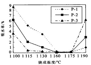
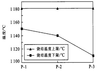
The exploitation of lake bottom sediments as raw materials of porcelain brick is believed to be profitable, eliminating the water pollution and reducing the consumption of clays employed in tranditional brick industry. Porcelain bricks were prepared using the bottom sediments from the East Lake in Wuhan and coal fly ash from Huangshi in Hubei as main raw materials, and granitic pegmatite and quartz as additives. Four mix-designs with 40%, 50%, 60% and 70% of the bottom sediments were tested under different sintering temperatures ranging from 1 100 to 1 190 ℃. XRD analysis indicates that the content of mullite in the porcelain bricks increases with the sintering temperature. The water absorption, rupture modulus of all porcelain bricks of the samples sintered at (1 160) and (1 175 ℃) are respectively 0.08%-0.20% and 39.36-(51.08 MPa). The results show the practicability to produce porcelain bricks using lake sediment and coal fly ash with a sum of 75%-80%.
The exploitation of lake bottom sediments as raw materials of porcelain brick is believed to be profitable, eliminating the water pollution and reducing the consumption of clays employed in tranditional brick industry. Porcelain bricks were prepared using the bottom sediments from the East Lake in Wuhan and coal fly ash from Huangshi in Hubei as main raw materials, and granitic pegmatite and quartz as additives. Four mix-designs with 40%, 50%, 60% and 70% of the bottom sediments were tested under different sintering temperatures ranging from 1 100 to 1 190 ℃. XRD analysis indicates that the content of mullite in the porcelain bricks increases with the sintering temperature. The water absorption, rupture modulus of all porcelain bricks of the samples sintered at (1 160) and (1 175 ℃) are respectively 0.08%-0.20% and 39.36-(51.08 MPa). The results show the practicability to produce porcelain bricks using lake sediment and coal fly ash with a sum of 75%-80%.


2004, 29(3): 352-356.
Abstract:
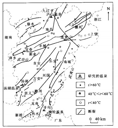
A comparative study was conducted to probe the feasibility of conventional and fixed-Al modified log (Q/K) graph on hot spring system. Lushan hot spring, Tanghu hot spring and Hengjing hot spring in Jiangxi Province were selected to reconstruct the reservoir equilibrium by log (Q/K) graph, and all the calculation were carried out by WATCH program. Due to the lack of Al in the water analytical data, only chalcedony and calcite intersected around 100 ℃ in normal log (Q/K) graph. So no equilibrium status or temperature could be reconstructed by this method. Calculated by the method by combining the fixed-Al method with the mixing factor, minerals association of laumontite, chrysotile, fluorite and chalcedony converged around 100-140 ℃ in fixed-Al modified log (Q/K) graph, which means the equilibrium status could be successfully reconstructed. These mineral assembles occurred in the borehole of Tanghu hot spring field. The calculating result corresponds with the real hot spring system, which might infer that the fixed-Al log (Q/K) graph could be used to reconstruct the reservoir equilibrium in hot spring system.
A comparative study was conducted to probe the feasibility of conventional and fixed-Al modified log (Q/K) graph on hot spring system. Lushan hot spring, Tanghu hot spring and Hengjing hot spring in Jiangxi Province were selected to reconstruct the reservoir equilibrium by log (Q/K) graph, and all the calculation were carried out by WATCH program. Due to the lack of Al in the water analytical data, only chalcedony and calcite intersected around 100 ℃ in normal log (Q/K) graph. So no equilibrium status or temperature could be reconstructed by this method. Calculated by the method by combining the fixed-Al method with the mixing factor, minerals association of laumontite, chrysotile, fluorite and chalcedony converged around 100-140 ℃ in fixed-Al modified log (Q/K) graph, which means the equilibrium status could be successfully reconstructed. These mineral assembles occurred in the borehole of Tanghu hot spring field. The calculating result corresponds with the real hot spring system, which might infer that the fixed-Al log (Q/K) graph could be used to reconstruct the reservoir equilibrium in hot spring system.


Determining Criterions for Natural Biodegradation of Chlorinated Hydrocarbons in Shallow Groundwater
2004, 29(3): 357-362.
Abstract:
Natural biodegradation is one of the important processes resulting in the decrease of chlorinated pollutants in environments. Identification of the occurrence of natural biodegradation is thus the key issue to evaluate the practicability of the natural attenuation of these compounds. Through the analysis of the characteristics of biodegradation, we found that, the biodegradation of chlorinated compounds in groundwater environments always leads to the visible change of electron acceptors, primary substances, intermediate products, and other indirect indexes. The spatial variation of these substances around the different locations of the polluted plumes is proposed to be a consequence of biodegradation of chlorinated compounds. On this basis, this paper summarized the determining criterions for the evaluation of biodegradation of chlorinated hydrocarbons in groundwater under natural conditions, including electron acceptors, primary substances and intermediate products.
Natural biodegradation is one of the important processes resulting in the decrease of chlorinated pollutants in environments. Identification of the occurrence of natural biodegradation is thus the key issue to evaluate the practicability of the natural attenuation of these compounds. Through the analysis of the characteristics of biodegradation, we found that, the biodegradation of chlorinated compounds in groundwater environments always leads to the visible change of electron acceptors, primary substances, intermediate products, and other indirect indexes. The spatial variation of these substances around the different locations of the polluted plumes is proposed to be a consequence of biodegradation of chlorinated compounds. On this basis, this paper summarized the determining criterions for the evaluation of biodegradation of chlorinated hydrocarbons in groundwater under natural conditions, including electron acceptors, primary substances and intermediate products.


2004, 29(3): 363-368.
Abstract:
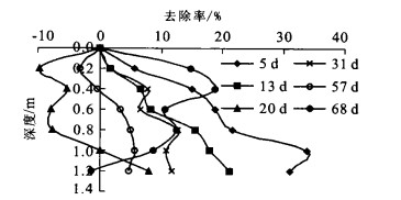
NH4-N pollution in surface water and groundwater is currently very severe. Experiment simulation of NH4-N migration was carried out in a column filled with three kinds of natural sand under the reflux of domestic sewage. Adsorption saturation of NH4-N in the column was reached within 17 days for the coarse sand and 130-140 days for the medium sand, suggesting the easiness of NH4-N migration to groundwater. However, the field test in Liangshui River and its groundwater is incompatible with the experimental observation. When the concentration of NH4-N reached 46.86 and 26.95 mg/L in Liangshui River, the groundwater has a NH4-N concentration of less than 1.10 mg/L. The little influence of Liangshui River on the groundwater NH4-N was attributed to the bottom mud, the thickness and character of the infiltration media underlying the river bed as well as the seepage quantity of the river. Importantly, the NH4-N absorbed by the penetration media underlying the sewage-received river would be transported into the groundwater after addition of clean water and cleanup of the mud, causing a secondary pollution of groundwater.
NH4-N pollution in surface water and groundwater is currently very severe. Experiment simulation of NH4-N migration was carried out in a column filled with three kinds of natural sand under the reflux of domestic sewage. Adsorption saturation of NH4-N in the column was reached within 17 days for the coarse sand and 130-140 days for the medium sand, suggesting the easiness of NH4-N migration to groundwater. However, the field test in Liangshui River and its groundwater is incompatible with the experimental observation. When the concentration of NH4-N reached 46.86 and 26.95 mg/L in Liangshui River, the groundwater has a NH4-N concentration of less than 1.10 mg/L. The little influence of Liangshui River on the groundwater NH4-N was attributed to the bottom mud, the thickness and character of the infiltration media underlying the river bed as well as the seepage quantity of the river. Importantly, the NH4-N absorbed by the penetration media underlying the sewage-received river would be transported into the groundwater after addition of clean water and cleanup of the mud, causing a secondary pollution of groundwater.


2004, 29(3): 369-374.
Abstract:
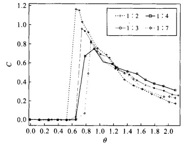
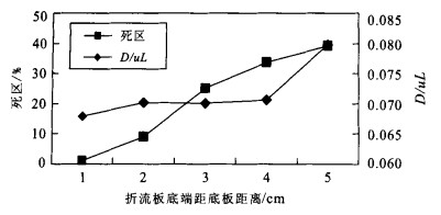
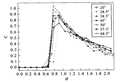
To provide guidance for the structure design of anaerobic baffled reactor (ABR), a study has been carried out on the influence of structure parameters such as the ratio of width of downflow chamber to upflow chamber, the distance of baffle to bottom, and the value of the angle of baffle on the hydrodynamic characteristics of the ABR. Anaerobic baffled (reactor's) typical structure is composed of a series of identical units. The reactor's hydrodynamic characteristics can be deduced from the characteristics of a single ABR unit. This paper presents residence time distribution studies on the influence of structure on a 5.25 L clean ABR unit. The results show that the fraction of dead space is lower compared to other type anaerobic reactors, and the type of flow in the ABR tends towards plug-flow. The data indicate that the optimal value of the ratio of width of downflow chamber to upflow chamber is 1∶3; the distance of baffle to bottom and dead space is in direct proportion to the range of this study (1-5 cm); and the optimal value of the angle of baffle is about 50°.
To provide guidance for the structure design of anaerobic baffled reactor (ABR), a study has been carried out on the influence of structure parameters such as the ratio of width of downflow chamber to upflow chamber, the distance of baffle to bottom, and the value of the angle of baffle on the hydrodynamic characteristics of the ABR. Anaerobic baffled (reactor's) typical structure is composed of a series of identical units. The reactor's hydrodynamic characteristics can be deduced from the characteristics of a single ABR unit. This paper presents residence time distribution studies on the influence of structure on a 5.25 L clean ABR unit. The results show that the fraction of dead space is lower compared to other type anaerobic reactors, and the type of flow in the ABR tends towards plug-flow. The data indicate that the optimal value of the ratio of width of downflow chamber to upflow chamber is 1∶3; the distance of baffle to bottom and dead space is in direct proportion to the range of this study (1-5 cm); and the optimal value of the angle of baffle is about 50°.


2004, 29(3): 375-378.
Abstract:
There appears to be random to design the penetration parameters for a bank or dam foundation. To solve this problem, this paper introduces a sensitivity analyzing method to calculate the penetration parameter's sensitivity factor of each part in the calculation model. The application of the method in Yanshan reservoir indicates that the covering layer's penetration parameter's sensitivity factor (> 10-2) is the biggest, whose design parameter should then be the biggest of the testing values. The sensitivity factors (10-6-10-3) of other parts are relatively small, whose design parameters can then be the mean values. As for the anti-penetration objects, if dense enough, the decrease of the penetration parameters will be insignificant.
There appears to be random to design the penetration parameters for a bank or dam foundation. To solve this problem, this paper introduces a sensitivity analyzing method to calculate the penetration parameter's sensitivity factor of each part in the calculation model. The application of the method in Yanshan reservoir indicates that the covering layer's penetration parameter's sensitivity factor (> 10-2) is the biggest, whose design parameter should then be the biggest of the testing values. The sensitivity factors (10-6-10-3) of other parts are relatively small, whose design parameters can then be the mean values. As for the anti-penetration objects, if dense enough, the decrease of the penetration parameters will be insignificant.