2004 Vol. 29, No. 5
Display Method:
2004, 29(5): 505-512.
 PDF 2146KB
Abstract:
A new stage of the basic and strategic research of petroleum geology has already started in recent years for discovering significant hydrocarbon accumulation in China. Geologists are facing great challenge and opportunities in this decade and the near future. A critical research field is to recognize the hydrocarbon-rich depressions and their relative petroleum systems in petroliferous basins. Based upon case studies of the Chinese basins, all hydrocarbon-rich depressions have their special basin dynamics background. The Bohaiwan basin is a most important representative one in eastern China. During rifting phase structure framework comprised by a number of half-grabens and associated horsts, rapid subsidence, high geothermal and (overpressured) chambers within source rocks offered excellent conditions for the formation of huge petroleum systems under the lithospheric extension setting. Optimum paleo-climite and lake types in Eocene time may be favorable for the formation of high quality oil source rocks. Two concept models on petroleum system in the Bohaiwan rift basin have been proposed based upon the integrated research of basin evolution and case studies of hydrocarbon accumulation in typical depressions. It is worthy to note that most of important hydrocarbon-generating depressions in large scale superpositional basins of northwest China are also formed in extensional setting, such as the Permian central depression of the junggar basin, the Manjiaer depression of the Tarim basin. The research results elaborate the dynamic processes of hydrocarbon-generating depressions and provide an important theoretical base for the exploration of large oil and gas fields.
A new stage of the basic and strategic research of petroleum geology has already started in recent years for discovering significant hydrocarbon accumulation in China. Geologists are facing great challenge and opportunities in this decade and the near future. A critical research field is to recognize the hydrocarbon-rich depressions and their relative petroleum systems in petroliferous basins. Based upon case studies of the Chinese basins, all hydrocarbon-rich depressions have their special basin dynamics background. The Bohaiwan basin is a most important representative one in eastern China. During rifting phase structure framework comprised by a number of half-grabens and associated horsts, rapid subsidence, high geothermal and (overpressured) chambers within source rocks offered excellent conditions for the formation of huge petroleum systems under the lithospheric extension setting. Optimum paleo-climite and lake types in Eocene time may be favorable for the formation of high quality oil source rocks. Two concept models on petroleum system in the Bohaiwan rift basin have been proposed based upon the integrated research of basin evolution and case studies of hydrocarbon accumulation in typical depressions. It is worthy to note that most of important hydrocarbon-generating depressions in large scale superpositional basins of northwest China are also formed in extensional setting, such as the Permian central depression of the junggar basin, the Manjiaer depression of the Tarim basin. The research results elaborate the dynamic processes of hydrocarbon-generating depressions and provide an important theoretical base for the exploration of large oil and gas fields.


2004, 29(5): 513-517.
Abstract:
The Tertiary offshore Chinese basins have been undergoing the most rapid post-rift thermal subsidence since the end of the Miocene (about 5.2 Ma). The thermal subsidence is accompanied by tectonic re-activation. Tectonic movements, i.e. the neotectonics as defined in this paper, modify and control the ultimate petroleum accumulation and distribution in these offshore petroleum-bearing basins. The concept, distinguishing characteristics, genetic mechanism of the neotectonics as well as their controlling role on petroleum accumulation are presented and discussed in this paper. The main manifestations of the neotectonics in the offshore Chinese basins include the formation of unconformities on the end of the Miocene and the Pliocene within the sequences, the shift of sedimentation centers, the strong late-stage fault activities and the active natural earthquakes. The intensity, development mechanism of the neotectonics, and their controls on petroleum accumulation and distribution are quite different in different basins. Some case studies from the Bozhong depression in the Bohai Bay basin, the Yinggehai basin in the South China Sea, and the Xihu depression in the East China Sea basin indicate that the neotectonics plays an important role on late petroleum accumulation in the offshore Chinese basins.
The Tertiary offshore Chinese basins have been undergoing the most rapid post-rift thermal subsidence since the end of the Miocene (about 5.2 Ma). The thermal subsidence is accompanied by tectonic re-activation. Tectonic movements, i.e. the neotectonics as defined in this paper, modify and control the ultimate petroleum accumulation and distribution in these offshore petroleum-bearing basins. The concept, distinguishing characteristics, genetic mechanism of the neotectonics as well as their controlling role on petroleum accumulation are presented and discussed in this paper. The main manifestations of the neotectonics in the offshore Chinese basins include the formation of unconformities on the end of the Miocene and the Pliocene within the sequences, the shift of sedimentation centers, the strong late-stage fault activities and the active natural earthquakes. The intensity, development mechanism of the neotectonics, and their controls on petroleum accumulation and distribution are quite different in different basins. Some case studies from the Bozhong depression in the Bohai Bay basin, the Yinggehai basin in the South China Sea, and the Xihu depression in the East China Sea basin indicate that the neotectonics plays an important role on late petroleum accumulation in the offshore Chinese basins.


2004, 29(5): 518-524.
Abstract:
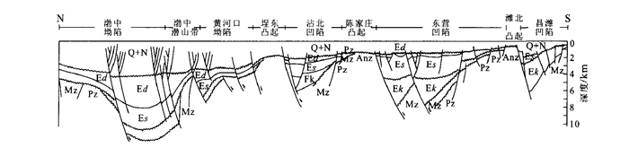
Since the beginning of the deposition of Dongying Formation, the Bozhong depression has had the highest subsidence-sedimentation rates and the strongest late-stage (since 5.1 Ma) fault activity in the Bohai Bay basin. High subsidence-sedimentation rates have had very important "material" effects on petroleum accumulation. On one hand, both Dongying and Shahejie formations comprise effective source rocks in the Bozhong depression because of much thick overlying strata, whereas only Shahejie Formation is taken as effective source rocks in almost all other depressions in Bohai Bay basin. On the other hand, strong overpressure caused by compaction disequilibrium due to rapid subsidence and sedimentation retarded organic matter maturation especially hydrocarbon thermal destruction and delayed petroleum expulsion, which made both Shahejie and Dongying formations remain in a favorable conditions for petroleum generation and expulsion during late stage (since (5.1 Ma)). The "material effect" is a key for the rapid petroleum accumulation around Bozhong depression. The combination of strong overpressure and strong faulting during late stage controlled fluid flow as a result of episodic petroleum accumulation. Hence, such a process controls the distribution of petroleum occurring in Neogene strata.
Since the beginning of the deposition of Dongying Formation, the Bozhong depression has had the highest subsidence-sedimentation rates and the strongest late-stage (since 5.1 Ma) fault activity in the Bohai Bay basin. High subsidence-sedimentation rates have had very important "material" effects on petroleum accumulation. On one hand, both Dongying and Shahejie formations comprise effective source rocks in the Bozhong depression because of much thick overlying strata, whereas only Shahejie Formation is taken as effective source rocks in almost all other depressions in Bohai Bay basin. On the other hand, strong overpressure caused by compaction disequilibrium due to rapid subsidence and sedimentation retarded organic matter maturation especially hydrocarbon thermal destruction and delayed petroleum expulsion, which made both Shahejie and Dongying formations remain in a favorable conditions for petroleum generation and expulsion during late stage (since (5.1 Ma)). The "material effect" is a key for the rapid petroleum accumulation around Bozhong depression. The combination of strong overpressure and strong faulting during late stage controlled fluid flow as a result of episodic petroleum accumulation. Hence, such a process controls the distribution of petroleum occurring in Neogene strata.


2004, 29(5): 525-530.
Abstract:
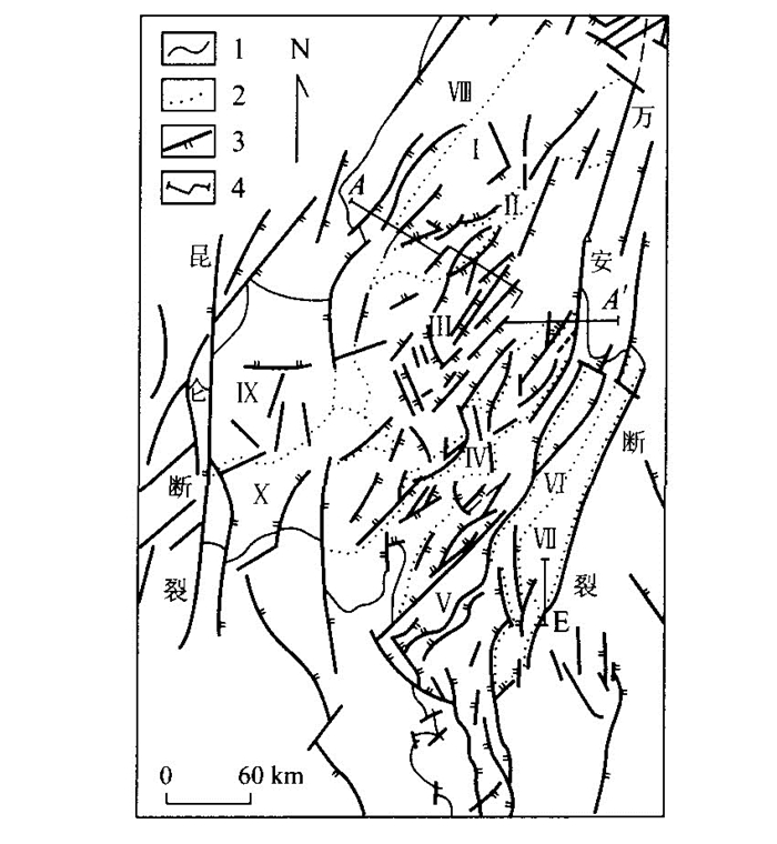
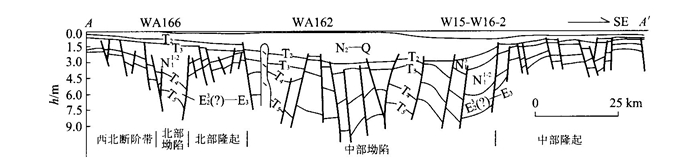
The Wan'an basin, located in the southwestern part of the South China Sea, belongs to a large scale pull-apart basin. The central depression of this basin is an abundant hydrocarbon-generating sag, which includes two sets of source rocks, that are Oligocene lacustrine mudstones, Early-Middle Miocene marine mudstones. The Oligocene lacustrine source rocks in this depression contain dominantly type Ⅰ-Ⅱ kerogen with high organic carbon contents ranging from 0.50% to (2.26%) and increasing usually from margin to depression center. The Early Miocene marine source rocks comprise types (Ⅱ-) Ⅲ kerogen and have a relatively low organic carbon content of 0.69%-0.93%. Potential hydrocarbon source index in the most of the depression has ranges of 4-10 t/m2 with a maximum value of 14 t/m2 in the Oligocene source rocks and of 4-7 t/m2 in Early Miocene source rocks. The oil-gas pools in the Wan'an basin are mainly distributed in the central depression and its adjacent areas including the NW fault-step belt, the northern and central lifts. But in the southern and northern depressions and nearby eastern lift, only a few hydrocarbon shows are observed. The results indicate that the oil-gas distribution in the Wan'an basin is obviously controlled by the abundant hydrocarbon-generating sag.
The Wan'an basin, located in the southwestern part of the South China Sea, belongs to a large scale pull-apart basin. The central depression of this basin is an abundant hydrocarbon-generating sag, which includes two sets of source rocks, that are Oligocene lacustrine mudstones, Early-Middle Miocene marine mudstones. The Oligocene lacustrine source rocks in this depression contain dominantly type Ⅰ-Ⅱ kerogen with high organic carbon contents ranging from 0.50% to (2.26%) and increasing usually from margin to depression center. The Early Miocene marine source rocks comprise types (Ⅱ-) Ⅲ kerogen and have a relatively low organic carbon content of 0.69%-0.93%. Potential hydrocarbon source index in the most of the depression has ranges of 4-10 t/m2 with a maximum value of 14 t/m2 in the Oligocene source rocks and of 4-7 t/m2 in Early Miocene source rocks. The oil-gas pools in the Wan'an basin are mainly distributed in the central depression and its adjacent areas including the NW fault-step belt, the northern and central lifts. But in the southern and northern depressions and nearby eastern lift, only a few hydrocarbon shows are observed. The results indicate that the oil-gas distribution in the Wan'an basin is obviously controlled by the abundant hydrocarbon-generating sag.


2004, 29(5): 531-538.
Abstract:
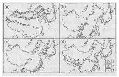
Seismic Pn waves sample the top of the upper mantle right beneath the Moho. Because Pn velocity varies with changes in temperature and material composition and Pn anisotropy may indicate the history of mantle deformation, Pn velocity and anisotropy have become an important tool to probe lithospheric structure. The lithosphere mantle Pn velocities of China are characterized by a mosaic of very fast and very slow anomalies, mirroring the heterogenity of geology at surface. The major basins in the west (Tarim, Junggar, Tuha, Qaidam, and Sichuan basins) have high Pn velocities and small Pn anisotropy, which suggests that the lithosphere of these basins is cold and strong with little deformation. A large area of North China shows prominent low Pn velocities beneath the Archean basement. Our observations are consistent with rifting, lithospheric thinning, and mantle upwelling in the region. The Pn anisotropy is consistent with a dextral simple shear in the NNE direction in the lithosphere mantle during the last (and ongoing) major deformation period. The locations of gold ore deposits in North China and oil deposits in North China and Songliao basins correlate remarkably well with low Pn velocities of the region, suggesting the metallogenesis and oil formation of the region may be closely related to magma and thermal activity in lithospheric mantle and crust-mantle interaction since Mesozoic and Cenozoic.
Seismic Pn waves sample the top of the upper mantle right beneath the Moho. Because Pn velocity varies with changes in temperature and material composition and Pn anisotropy may indicate the history of mantle deformation, Pn velocity and anisotropy have become an important tool to probe lithospheric structure. The lithosphere mantle Pn velocities of China are characterized by a mosaic of very fast and very slow anomalies, mirroring the heterogenity of geology at surface. The major basins in the west (Tarim, Junggar, Tuha, Qaidam, and Sichuan basins) have high Pn velocities and small Pn anisotropy, which suggests that the lithosphere of these basins is cold and strong with little deformation. A large area of North China shows prominent low Pn velocities beneath the Archean basement. Our observations are consistent with rifting, lithospheric thinning, and mantle upwelling in the region. The Pn anisotropy is consistent with a dextral simple shear in the NNE direction in the lithosphere mantle during the last (and ongoing) major deformation period. The locations of gold ore deposits in North China and oil deposits in North China and Songliao basins correlate remarkably well with low Pn velocities of the region, suggesting the metallogenesis and oil formation of the region may be closely related to magma and thermal activity in lithospheric mantle and crust-mantle interaction since Mesozoic and Cenozoic.


2004, 29(5): 539-542.
Abstract:
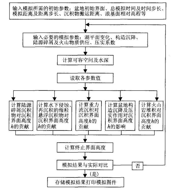
Understanding the filling process in response to variation of lake-level is important in faulted basin. In this paper, numerical simulation has been applied to analyze the filling characteristics of the Songliao faulted basin. To assess the effect of different parameters on the filling characteristics, lake-level change, tectonic subsidence and sediment supply are taken into consideration. Based on the filling features of the Songliao faulted basin, we simulated filling characteristics of this faulted basin during 3 lake-level fluctuated periods, in which tectonic subsidence and sediment supply are supposed as constants, and the lake-level change follows a sin-function. The modeling results indicated that: ① Variation of lake-level in the faulted basin is well compared with the global sea-level change. One cycle of lake-level change results in formation of a corresponding sequence, in which a sequence boundary formed at the lowstand period of lake-level; ② Amplitude of lake-level change controlled the distribution of corresponding sequence unit, the larger the lake-level change is, the larger the distribution area and the thicker the sedimentary thickness of the corresponding sequence are; ③ The sequence units due to lake-level change are well reserved at following favorable conditions, such as the subordinate lake-level change under the background of a continuous rise of lake-level or tectonic subsidence. The numerical modeling results in agreement with measured sequences have demonstrated the architecture of sequence units and filling processes in the Songliao faulted basin.
Understanding the filling process in response to variation of lake-level is important in faulted basin. In this paper, numerical simulation has been applied to analyze the filling characteristics of the Songliao faulted basin. To assess the effect of different parameters on the filling characteristics, lake-level change, tectonic subsidence and sediment supply are taken into consideration. Based on the filling features of the Songliao faulted basin, we simulated filling characteristics of this faulted basin during 3 lake-level fluctuated periods, in which tectonic subsidence and sediment supply are supposed as constants, and the lake-level change follows a sin-function. The modeling results indicated that: ① Variation of lake-level in the faulted basin is well compared with the global sea-level change. One cycle of lake-level change results in formation of a corresponding sequence, in which a sequence boundary formed at the lowstand period of lake-level; ② Amplitude of lake-level change controlled the distribution of corresponding sequence unit, the larger the lake-level change is, the larger the distribution area and the thicker the sedimentary thickness of the corresponding sequence are; ③ The sequence units due to lake-level change are well reserved at following favorable conditions, such as the subordinate lake-level change under the background of a continuous rise of lake-level or tectonic subsidence. The numerical modeling results in agreement with measured sequences have demonstrated the architecture of sequence units and filling processes in the Songliao faulted basin.

2004, 29(5): 543-549.
Abstract:
This paper discusses the distributing characteristics of petroleum in the South China Sea by comparing on the tectonic environments, the assemble of reservoirs, source and cap rocks between the southern and northern South China Sea in order to demonstrate the exploration guide of the petroleum. Petroleum potential in the southern margin of the South China Sea is better than that in the northern margin according to present petroleum exploration. Possible reasons causing such a difference may be grouped into the following aspects. Firstly, the southern South China margin belongs to an extruding environment in Cenozoic time, where the volume of source rocks is bigger than that in the northern margin belonging to a passive environment. Secondly, heat flow and geothermal gradient in the southern margin are higher than those in the northern margin, for example, heat flow in the Pearl River Mouth basin on the shelf of northern margin is 53-87 mW/m2 with an average value of 67 mW/m2; but in the Zengmu basin in the southern margin, an average heat flow is 97 mW/m2 with a maximum value of 130 mW/m2. This fact indicates that the maturation of source rocks in the southern margin is higher than that in the northern margin. Thirdly, many large scale oil-bearing structures in the southern margin are formed due to the extruding environments in Cenozoic time, but trap structures in the northern margin are relatively little in quantity and small in scale in extension environments. Finally, the coordination between the formation time of trap structures and hydrocarbon-generating time in the southern margin is also better than that in the northern margin. Present hydrocarbon exploration also shows that a number of big oil and gas fields exist in the southern margin, only medium-little oil and gas fields occur in the northern margin. Therefore, petroleum potential in the southern margin is richer than that in the northern margin of the South China Sea.
This paper discusses the distributing characteristics of petroleum in the South China Sea by comparing on the tectonic environments, the assemble of reservoirs, source and cap rocks between the southern and northern South China Sea in order to demonstrate the exploration guide of the petroleum. Petroleum potential in the southern margin of the South China Sea is better than that in the northern margin according to present petroleum exploration. Possible reasons causing such a difference may be grouped into the following aspects. Firstly, the southern South China margin belongs to an extruding environment in Cenozoic time, where the volume of source rocks is bigger than that in the northern margin belonging to a passive environment. Secondly, heat flow and geothermal gradient in the southern margin are higher than those in the northern margin, for example, heat flow in the Pearl River Mouth basin on the shelf of northern margin is 53-87 mW/m2 with an average value of 67 mW/m2; but in the Zengmu basin in the southern margin, an average heat flow is 97 mW/m2 with a maximum value of 130 mW/m2. This fact indicates that the maturation of source rocks in the southern margin is higher than that in the northern margin. Thirdly, many large scale oil-bearing structures in the southern margin are formed due to the extruding environments in Cenozoic time, but trap structures in the northern margin are relatively little in quantity and small in scale in extension environments. Finally, the coordination between the formation time of trap structures and hydrocarbon-generating time in the southern margin is also better than that in the northern margin. Present hydrocarbon exploration also shows that a number of big oil and gas fields exist in the southern margin, only medium-little oil and gas fields occur in the northern margin. Therefore, petroleum potential in the southern margin is richer than that in the northern margin of the South China Sea.

2004, 29(5): 550-554.
Abstract:
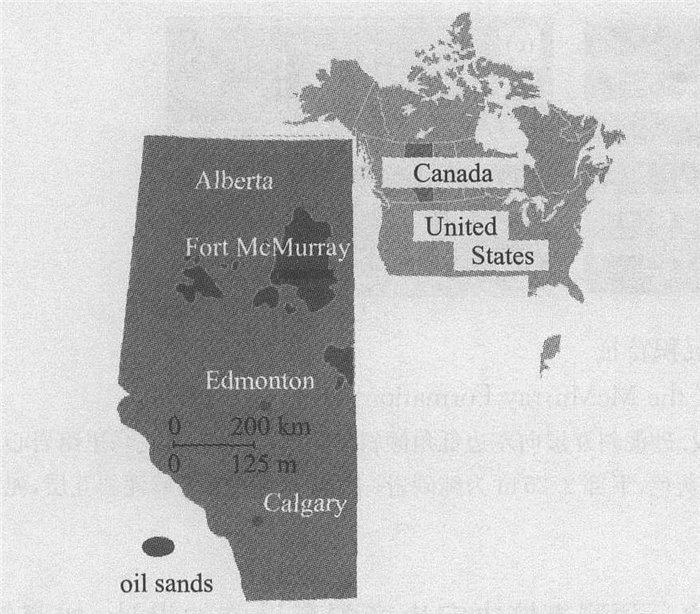
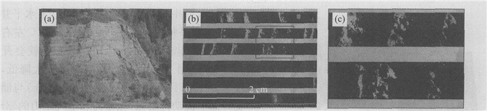
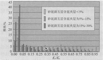
The Lower Cretaceous McMurray Formation in northeastern Alberta, Canada, hosts about 800 billion barrels (137 billion cubic meters) of bitumen in place. Interbeds of sand and mud (often called inclined heterolithic stratification, or IHS) exist in virtually every McMurray oil sand deposit. They may even be the dominant component in some oil sand successions. Their sedimentary characteristics and distribution in a reservoir for in-situ extraction using steam assisted gravity drainage (SAGD) technology, are important factors that determine SAGD performance and strategies of positioning horizontal well pairs. Therefore, characterization of IHS in an SAGD reservoir is a very important and valuable exercise to evaluate SAGD performance. To improve 3-D modeling on SAGD performance, mudstone interbeds are studied using several different approaches: variable resolution volume of shale (Vsh) qualification; grain size and fine analyses; mudstone interbed "types" classification; borehole image interpretation; vertical permeability (Kv) quantification of individual mudstone interbeds, (using) flow simulation techniques from core-based micro-models, core CT-scan image analyses, the study of connectivity between the sand beds that are separated by mudstone, and quantification of steam rise rates through or around mudstone interbeds. These studies confirm that mudstone interbeds in IHS can be very sandy and they can be discontinuous because of bioturbation, dewatering and/or erosion. Their Kv is highly variable. Some "mudstone interbeds" are actually mud-filled burrows that penetrated into sands from the top surface of the sands. All of these characteristics indicate that mudstone interbeds in IHS can be very leaky and are expected to be permeable to variable degrees during SAGD operations. This is especially true for those mudstone interbeds associated with sand-dominated IHS. SAGD reservoirs with IHS may behave quite differently, depending on IHS thickness and occurrence, individual mudstone interbed thickness, their Kv, and more importantly, their lateral extent.
The Lower Cretaceous McMurray Formation in northeastern Alberta, Canada, hosts about 800 billion barrels (137 billion cubic meters) of bitumen in place. Interbeds of sand and mud (often called inclined heterolithic stratification, or IHS) exist in virtually every McMurray oil sand deposit. They may even be the dominant component in some oil sand successions. Their sedimentary characteristics and distribution in a reservoir for in-situ extraction using steam assisted gravity drainage (SAGD) technology, are important factors that determine SAGD performance and strategies of positioning horizontal well pairs. Therefore, characterization of IHS in an SAGD reservoir is a very important and valuable exercise to evaluate SAGD performance. To improve 3-D modeling on SAGD performance, mudstone interbeds are studied using several different approaches: variable resolution volume of shale (Vsh) qualification; grain size and fine analyses; mudstone interbed "types" classification; borehole image interpretation; vertical permeability (Kv) quantification of individual mudstone interbeds, (using) flow simulation techniques from core-based micro-models, core CT-scan image analyses, the study of connectivity between the sand beds that are separated by mudstone, and quantification of steam rise rates through or around mudstone interbeds. These studies confirm that mudstone interbeds in IHS can be very sandy and they can be discontinuous because of bioturbation, dewatering and/or erosion. Their Kv is highly variable. Some "mudstone interbeds" are actually mud-filled burrows that penetrated into sands from the top surface of the sands. All of these characteristics indicate that mudstone interbeds in IHS can be very leaky and are expected to be permeable to variable degrees during SAGD operations. This is especially true for those mudstone interbeds associated with sand-dominated IHS. SAGD reservoirs with IHS may behave quite differently, depending on IHS thickness and occurrence, individual mudstone interbed thickness, their Kv, and more importantly, their lateral extent.


2004, 29(5): 555-562.
Abstract:
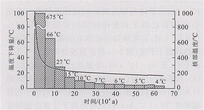
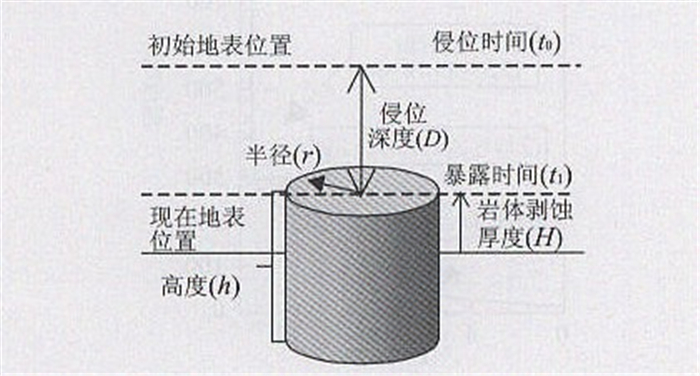
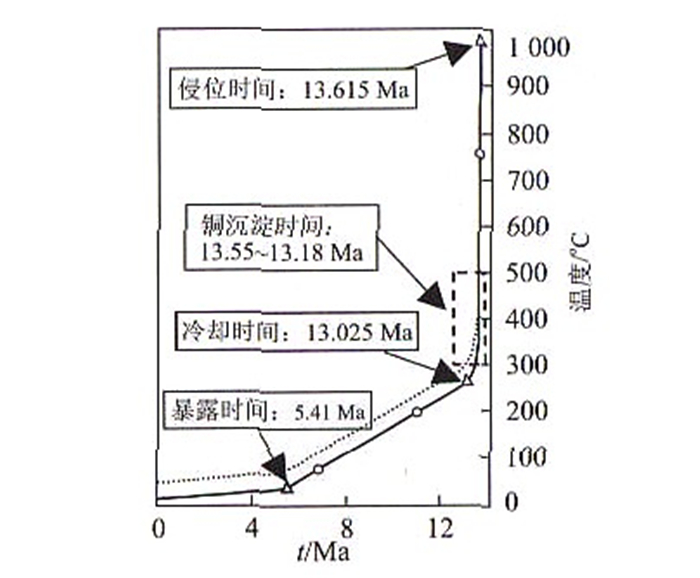
The purpose of this paper is to quantify the thermal and exhumation histories of magmatic ore deposits by combining U-Th-He thermochronometrical data with computer modelling techniques.The numerical modelling of magmatic cooling has been first attempted and then integrated with the exhumation cooling to produce a digitized cooling curve which is further constrained by U-Th-He thermochronometer.The modelling results indicate that the magmatic cooling of igneous bodies is complicated.The cooling history of an igneous body can be divided into two distinct stages.In the first stage, the igneous body cools rapidly while the ambient country rock is heated simultaneously.In the second stage, the temperature of the igneous body is slightly higher than or close to that of the country rock, but the geothermal gradient in the vicinity is still higher than the initial thermal conditions, and thus both the igneous and country rocks cool slowly until both reach a final thermal equilibration under the normal thermal conditions.The cooling of the igneous body is affected by many factors, among which the size and the emplacement depth are the principal factors controlling the cooling rates and the durations of the two cooling stages.The complete thermal history requires an understanding of the exhumation history and this is achieved by the combined modelling of thermal and exhumation cooling resulting in a temperature-age curve constrained by the apatite U-Th-He, zircon U-Th-He, and zircon U-Pb age data.The validity of this curve was successfully tested against data obtained from porphyry copper deposits in Iran.The digitized temperature-age curve defines the time and depth of emplacement, crystallization age of economic minerals, cooling rate, cooled and exposure ages, and exhumation/erosion rates for the porphyry copper deposit.Therefore, the combination of highly precise age dating and computer modelling techniques can not only quantify the thermal and exhumation histories of ore systems, but also provide an insight into the genesis of the ore deposits.
The purpose of this paper is to quantify the thermal and exhumation histories of magmatic ore deposits by combining U-Th-He thermochronometrical data with computer modelling techniques.The numerical modelling of magmatic cooling has been first attempted and then integrated with the exhumation cooling to produce a digitized cooling curve which is further constrained by U-Th-He thermochronometer.The modelling results indicate that the magmatic cooling of igneous bodies is complicated.The cooling history of an igneous body can be divided into two distinct stages.In the first stage, the igneous body cools rapidly while the ambient country rock is heated simultaneously.In the second stage, the temperature of the igneous body is slightly higher than or close to that of the country rock, but the geothermal gradient in the vicinity is still higher than the initial thermal conditions, and thus both the igneous and country rocks cool slowly until both reach a final thermal equilibration under the normal thermal conditions.The cooling of the igneous body is affected by many factors, among which the size and the emplacement depth are the principal factors controlling the cooling rates and the durations of the two cooling stages.The complete thermal history requires an understanding of the exhumation history and this is achieved by the combined modelling of thermal and exhumation cooling resulting in a temperature-age curve constrained by the apatite U-Th-He, zircon U-Th-He, and zircon U-Pb age data.The validity of this curve was successfully tested against data obtained from porphyry copper deposits in Iran.The digitized temperature-age curve defines the time and depth of emplacement, crystallization age of economic minerals, cooling rate, cooled and exposure ages, and exhumation/erosion rates for the porphyry copper deposit.Therefore, the combination of highly precise age dating and computer modelling techniques can not only quantify the thermal and exhumation histories of ore systems, but also provide an insight into the genesis of the ore deposits.


2004, 29(5): 563-568.
Abstract:
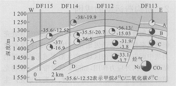
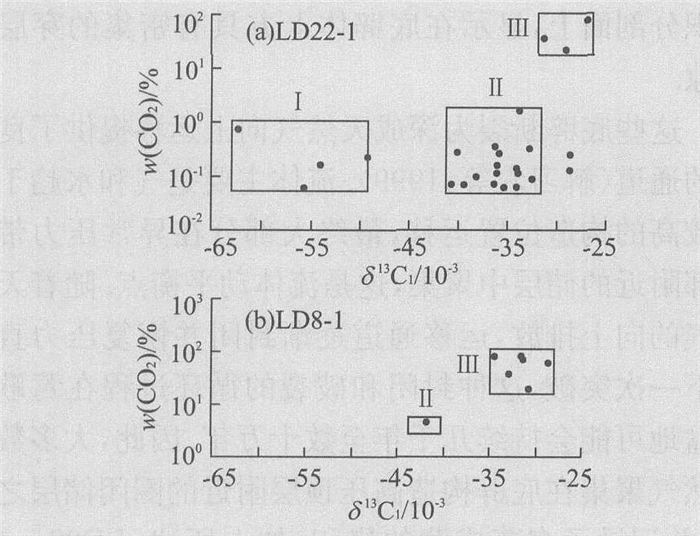
Based on the integrated analysis of geological and geochemical data, gas accumulation process is discussed in the Yinggehai basin by means of macro- and microapproaches. Interreservoir compositional heterogeneities in shallow gas field at diapiric structures indicate that hydrocarbon gases may undergo the processes of multiple mixing, episodic migration and accumulation. The faults at diapiric structures provide a good pathway for natural gas vertical migration from the deep source rocks into the shallow reservoirs as evidenced from high-resolution seismic images. Natural gases are derived from the Early Miocene Meishan and Middle Miocene Sanya source rocks distributed within overpressured zones. This overpressuring, together with active faulting, results in the episodic expulsion of fluids distributed within overpressured zones as a result of multiple infilling into shallow reservoir or leakage loss of hydrocarbon gases. Therefore, the short-lived rapid accumulation of hydrocarbon gases happens only about 1.2-0.1 Ma before the present time because of a plentiful of gas sources and high hydrocarbon expulsion efficiency.
Based on the integrated analysis of geological and geochemical data, gas accumulation process is discussed in the Yinggehai basin by means of macro- and microapproaches. Interreservoir compositional heterogeneities in shallow gas field at diapiric structures indicate that hydrocarbon gases may undergo the processes of multiple mixing, episodic migration and accumulation. The faults at diapiric structures provide a good pathway for natural gas vertical migration from the deep source rocks into the shallow reservoirs as evidenced from high-resolution seismic images. Natural gases are derived from the Early Miocene Meishan and Middle Miocene Sanya source rocks distributed within overpressured zones. This overpressuring, together with active faulting, results in the episodic expulsion of fluids distributed within overpressured zones as a result of multiple infilling into shallow reservoir or leakage loss of hydrocarbon gases. Therefore, the short-lived rapid accumulation of hydrocarbon gases happens only about 1.2-0.1 Ma before the present time because of a plentiful of gas sources and high hydrocarbon expulsion efficiency.


2004, 29(5): 569-574.
Abstract:
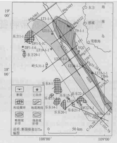
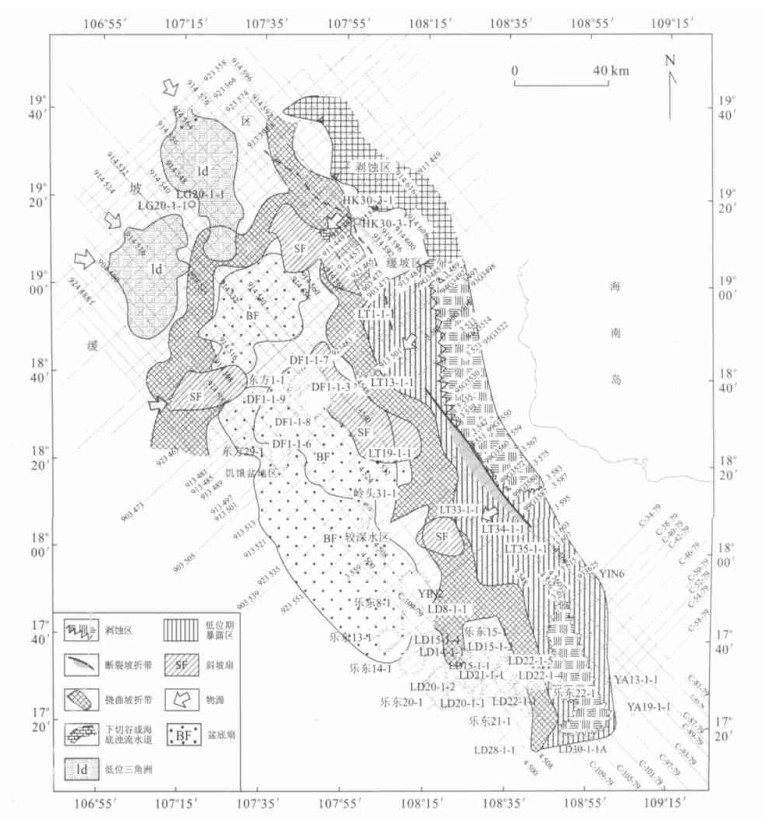
The slope-break is thought to be an important criterion to distinguish the patterns of sequences. In the Yinggehai basin, the slope-break can be classified into two types: structural and sedimentary slope-break zones, which can be divided further into four patterns, that are bend slope-break, fault slope-break(growing fault), sedimentary slope-break(shelf/slope-break)and gentle slope types. Different patterns of sequences control different distributions of lowstand sandstones. The bend slope-break, fault slope-break and sedimentary slope-break restrict the distribution of slope fans and basin floor fans in the third-order sequences, and the gentle slope-break limits the distribution of lowstand deltas which were formed in the course of restricted sea-level decrease. The results of tectonic researches show that the marginal faults, such as the No.1 fault and the Yingdong fault, still are active during the post-rifting stage, which controlled the formation of slope-break in this basin.
The slope-break is thought to be an important criterion to distinguish the patterns of sequences. In the Yinggehai basin, the slope-break can be classified into two types: structural and sedimentary slope-break zones, which can be divided further into four patterns, that are bend slope-break, fault slope-break(growing fault), sedimentary slope-break(shelf/slope-break)and gentle slope types. Different patterns of sequences control different distributions of lowstand sandstones. The bend slope-break, fault slope-break and sedimentary slope-break restrict the distribution of slope fans and basin floor fans in the third-order sequences, and the gentle slope-break limits the distribution of lowstand deltas which were formed in the course of restricted sea-level decrease. The results of tectonic researches show that the marginal faults, such as the No.1 fault and the Yingdong fault, still are active during the post-rifting stage, which controlled the formation of slope-break in this basin.

2004, 29(5): 575-582.
Abstract:
This paper reviews the main progress on the impact hypothesis of the Pacific Ocean for the past two decades and discusses the internal and external dynamics mechanism causing disappearance of ancient land of the Pacific Ocean. The impaction event which happened between Permian and Triassic at the Pacific Ocean area resulted in the crash of the Pacific lithospheric plate, and changeed greatly the mode of mantle convection. Under the action driven by the new mantle convection, ancient plate fragments of the Pacific Ocean withered away gradually and coalesced into the adjacent plates around the Pacific Ocean with the collision and subduction of paleo-pacific plate. At the same time, a tectonic system of the surrounding Pacific Ocean began to form. The deep tectonic-thermal regime embracing the surrounding Pacific Ocean tectonic system severely affected the magma activity in the continental plates ajacent Pacific Ocean during Mesozoic and Cenozoic.
This paper reviews the main progress on the impact hypothesis of the Pacific Ocean for the past two decades and discusses the internal and external dynamics mechanism causing disappearance of ancient land of the Pacific Ocean. The impaction event which happened between Permian and Triassic at the Pacific Ocean area resulted in the crash of the Pacific lithospheric plate, and changeed greatly the mode of mantle convection. Under the action driven by the new mantle convection, ancient plate fragments of the Pacific Ocean withered away gradually and coalesced into the adjacent plates around the Pacific Ocean with the collision and subduction of paleo-pacific plate. At the same time, a tectonic system of the surrounding Pacific Ocean began to form. The deep tectonic-thermal regime embracing the surrounding Pacific Ocean tectonic system severely affected the magma activity in the continental plates ajacent Pacific Ocean during Mesozoic and Cenozoic.


2004, 29(5): 583-588.
Abstract:
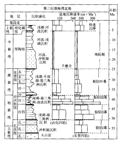
Integrated analysis of basin filling and tectonic evolution, aimed with computer modeling technique, reveals the dynamic process of basin subsidence, sedimentary infill, structure and thermal evolution in response to the multiple rifting processes of the Mesozoic-Cenozoic rift basins in eastern China. The synrift phases of these basins, such as the Bohaiwan and Jianghan basins, usually include 3 to 4 rifting episodes, and the trends of syndepositional faults, the type of volcanic rocks and the distribution of depocenters and depositional systems changed significantly in different rifting stages. The episodic change in tectonic subsidence rate controls the development and evolution of the regional(the second order)sequences. In intensively rifting subsidence episodes, deep lacustrine basin sequences are usually observed, while during the initial and final rifting episodes shallow lacustrine and fluvial basin sequences commonly form. The process of episodic rifting significantly differs from that of the simple rifting in tectonic subsidence and deep heat flow, and can not be accurately described by a simple(one episode)stretching model. Through correction of the initial stretching condition of each rifting episode and stretching index, we have programmed a multiple uniform instantaneous stretching model to simulate the formation of the basins. This model has been applied to reconstruct the lithosphere structure and to evaluate the deep thermal evolution of the Yinggehai basin. The calculated results are in agreement with geophysical data and geological observation in the basin.
Integrated analysis of basin filling and tectonic evolution, aimed with computer modeling technique, reveals the dynamic process of basin subsidence, sedimentary infill, structure and thermal evolution in response to the multiple rifting processes of the Mesozoic-Cenozoic rift basins in eastern China. The synrift phases of these basins, such as the Bohaiwan and Jianghan basins, usually include 3 to 4 rifting episodes, and the trends of syndepositional faults, the type of volcanic rocks and the distribution of depocenters and depositional systems changed significantly in different rifting stages. The episodic change in tectonic subsidence rate controls the development and evolution of the regional(the second order)sequences. In intensively rifting subsidence episodes, deep lacustrine basin sequences are usually observed, while during the initial and final rifting episodes shallow lacustrine and fluvial basin sequences commonly form. The process of episodic rifting significantly differs from that of the simple rifting in tectonic subsidence and deep heat flow, and can not be accurately described by a simple(one episode)stretching model. Through correction of the initial stretching condition of each rifting episode and stretching index, we have programmed a multiple uniform instantaneous stretching model to simulate the formation of the basins. This model has been applied to reconstruct the lithosphere structure and to evaluate the deep thermal evolution of the Yinggehai basin. The calculated results are in agreement with geophysical data and geological observation in the basin.


2004, 29(5): 589-595.
Abstract:
Hydrocarbon generation, migration and accumulation are closely related to activity of the basin fluid. Fluid flow in abnormally pressured environments shows different hydrodynamic processes as a result of associated distinct models of hydrocarbon accumulation. Two kinds of fluid flow systems have been classified in abnormally pressured environments including overpressure and underpressure, i.e. semi-opened and closed systems. In the former, opening of seal beds result in episodic fluid expulsion; but in the latter, thermal convection is dominant in anomalous pressured system. The opening mechanisms of seal beds can be grouped into three kinds of patterns, hydrofracturing, faulting and combination action of both faulting and pressuring. Opening of seal beds constitutes main pathways of hydrocarbon from abnormally pressured system. These fluids flowing from deep overpressured strata to seafloor have been identified using different geophysical data, which are imaged as gas blow-out, pockmark, chimney, fluid diapir, and so on. Some resided remarks or anomalous phenomena recorded in depositional rocks can be used to identify the active processes of fluid, such as fluid inclusions, geochemical features of formation water, anomaly in organic matters and diagenetic processes. At the same time, quantitative modeling can be used to present the dynamic processes of fluid flow. These results can constrain the realm of main migration pathways of fluid flow and hydrocarbon, and provide the useful information for hydrocarbon exploration in abnormally pressured environments.
Hydrocarbon generation, migration and accumulation are closely related to activity of the basin fluid. Fluid flow in abnormally pressured environments shows different hydrodynamic processes as a result of associated distinct models of hydrocarbon accumulation. Two kinds of fluid flow systems have been classified in abnormally pressured environments including overpressure and underpressure, i.e. semi-opened and closed systems. In the former, opening of seal beds result in episodic fluid expulsion; but in the latter, thermal convection is dominant in anomalous pressured system. The opening mechanisms of seal beds can be grouped into three kinds of patterns, hydrofracturing, faulting and combination action of both faulting and pressuring. Opening of seal beds constitutes main pathways of hydrocarbon from abnormally pressured system. These fluids flowing from deep overpressured strata to seafloor have been identified using different geophysical data, which are imaged as gas blow-out, pockmark, chimney, fluid diapir, and so on. Some resided remarks or anomalous phenomena recorded in depositional rocks can be used to identify the active processes of fluid, such as fluid inclusions, geochemical features of formation water, anomaly in organic matters and diagenetic processes. At the same time, quantitative modeling can be used to present the dynamic processes of fluid flow. These results can constrain the realm of main migration pathways of fluid flow and hydrocarbon, and provide the useful information for hydrocarbon exploration in abnormally pressured environments.


2004, 29(5): 596-602.
Abstract:
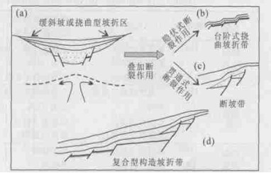
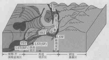
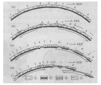
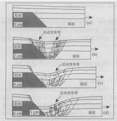
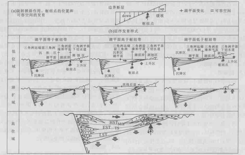
Faulted basin is a kind of typical tectonic active basin, in which there are various kinds of tectonic slope-breaks controlled by different tectonic backgrounds and mechanisms. Based on the researches on Mesozoic and Cenozoic faulted basinsin eastern China, classification system on structural slope-break of faulted basin is put forward, basic characteristics and forming mechanism of various kinds of structural slope-break have been described in detail and synthetic models of sequence stratigraphic development in continental faulted basin are set up in this paper. Structural slope-break in faulted basin can be divided into fault slope-break, bend slope-break, flexure slope-break and pivotal slope-break. The fault slope-break is controlled by syndepositional faulting within the basin, the formation of the bend slope-break is related to listric geometry of major boundary fault in faulted basin, while the flexure slope-break often results from activity of blind normal fault in the basin basement. Different from above three slope-breaks, the formation of the pivotal slope-break is a result of rotational tilting of hanging wall of normal fault, the development is mainly controlled by main boundary normal fault with steep dip and plane geometry. Development, distribution in space, evolution process and assemblage pattern of structural slope-break determind accommodation and sediment influx system in faulted basin, further it restricts sediment disperse process and distributional pattern of sand bodies in faulted basin. The researches on relationship between structural slope-break and depositional facies will be a great help to illustrate distribution of depositional systems and promote prediction availability of sand bodies in sedimentary basin.
Faulted basin is a kind of typical tectonic active basin, in which there are various kinds of tectonic slope-breaks controlled by different tectonic backgrounds and mechanisms. Based on the researches on Mesozoic and Cenozoic faulted basinsin eastern China, classification system on structural slope-break of faulted basin is put forward, basic characteristics and forming mechanism of various kinds of structural slope-break have been described in detail and synthetic models of sequence stratigraphic development in continental faulted basin are set up in this paper. Structural slope-break in faulted basin can be divided into fault slope-break, bend slope-break, flexure slope-break and pivotal slope-break. The fault slope-break is controlled by syndepositional faulting within the basin, the formation of the bend slope-break is related to listric geometry of major boundary fault in faulted basin, while the flexure slope-break often results from activity of blind normal fault in the basin basement. Different from above three slope-breaks, the formation of the pivotal slope-break is a result of rotational tilting of hanging wall of normal fault, the development is mainly controlled by main boundary normal fault with steep dip and plane geometry. Development, distribution in space, evolution process and assemblage pattern of structural slope-break determind accommodation and sediment influx system in faulted basin, further it restricts sediment disperse process and distributional pattern of sand bodies in faulted basin. The researches on relationship between structural slope-break and depositional facies will be a great help to illustrate distribution of depositional systems and promote prediction availability of sand bodies in sedimentary basin.


2004, 29(5): 603-608.
Abstract:
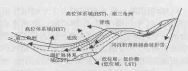
Based on integrated analysis of high-resolution 3D seismic sections, log curves and abundant geological data, basin filling sequence in the Lower Tertiary Nanpu depression consists of one super sequence set, four super sequences, and eleven third-order sequences. The North Liuzhan fan delta system can be divided further into six fourth-order sequences. Two kinds of slope-breaks are developed in this basin, one is the syndepositional fault slope-break, the other is the syndepositional bend slope-break, which control clearly sequence types and stratigraphic models. Corresponding two kinds of sequence patterns are observed in Lower Tertiary Nanpu depression, that are the syndepositional fault slope-break and syndepositional bend slope-break sequences. The lowstand sand bodies and highstand sand bodiesin the both sequences are favorable for hydrocarbon accumulation, and can be identified on seismic section easily, hence, they are taken as main targets for subtle trap exploration.
Based on integrated analysis of high-resolution 3D seismic sections, log curves and abundant geological data, basin filling sequence in the Lower Tertiary Nanpu depression consists of one super sequence set, four super sequences, and eleven third-order sequences. The North Liuzhan fan delta system can be divided further into six fourth-order sequences. Two kinds of slope-breaks are developed in this basin, one is the syndepositional fault slope-break, the other is the syndepositional bend slope-break, which control clearly sequence types and stratigraphic models. Corresponding two kinds of sequence patterns are observed in Lower Tertiary Nanpu depression, that are the syndepositional fault slope-break and syndepositional bend slope-break sequences. The lowstand sand bodies and highstand sand bodiesin the both sequences are favorable for hydrocarbon accumulation, and can be identified on seismic section easily, hence, they are taken as main targets for subtle trap exploration.


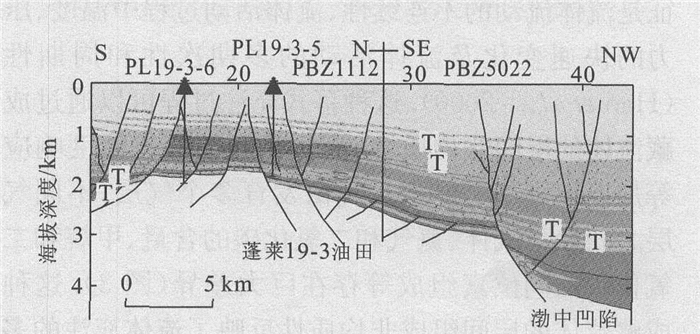
2004, 29(5): 609-614.
Abstract:
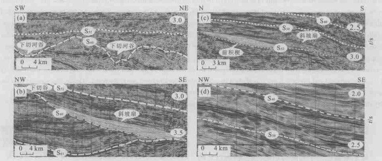
The Sanya Formation is one of the most important exploration layersin the area ajacent ② fault belt, central and eastern Qiongdongnan basin. The Sanya Formation can be divided into two third-order sequences (S60-S52, S52-S50) based on the integrated analysis of seismic and logging well data. The sequence of S60-S52 is formed on the beginning of thermal subsidence after rifting. This sequence and overlying one of S52-S50 are characterized by occurrence of the flexural slope-break, which is controlled by deep buried faults. Two slope-breaks constrain the development of system tracts in third-order sequence. Incised valley and slope fan are observed commonly in lowstand system tracts(LST)of the S60-S52 sequence, progradational wedge and slope fan occur widely in LSTof the S52-S50 sequence. Depositional systemsin transgressive system tracts and highstand system tracts are also controlled by double shelf slope-break zones which are taken as the boundary of different depositional systems from littoral shelf to continental slope, bathyal sea to deep sea. The results suggest that the Sanya Formation near the ② fault belt taken as the slope break zone is a favorable area for hydrocarbon exploration.
The Sanya Formation is one of the most important exploration layersin the area ajacent ② fault belt, central and eastern Qiongdongnan basin. The Sanya Formation can be divided into two third-order sequences (S60-S52, S52-S50) based on the integrated analysis of seismic and logging well data. The sequence of S60-S52 is formed on the beginning of thermal subsidence after rifting. This sequence and overlying one of S52-S50 are characterized by occurrence of the flexural slope-break, which is controlled by deep buried faults. Two slope-breaks constrain the development of system tracts in third-order sequence. Incised valley and slope fan are observed commonly in lowstand system tracts(LST)of the S60-S52 sequence, progradational wedge and slope fan occur widely in LSTof the S52-S50 sequence. Depositional systemsin transgressive system tracts and highstand system tracts are also controlled by double shelf slope-break zones which are taken as the boundary of different depositional systems from littoral shelf to continental slope, bathyal sea to deep sea. The results suggest that the Sanya Formation near the ② fault belt taken as the slope break zone is a favorable area for hydrocarbon exploration.


2004, 29(5): 615-620.
Abstract:
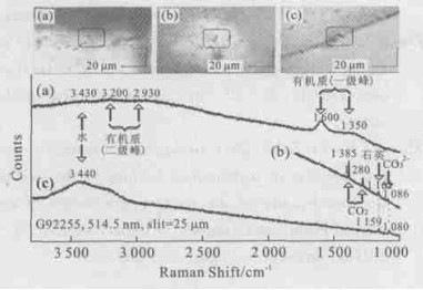
The formation of sandstone-type uranium depositsis not only related to sedimentary environment, but also related to diagenesis environment. This paper illustrates the original sedimentary environment of the Shuixigou Group using sedimentology methods and analysis results of element geochemistry in mudstone, and discusses the diagenesis environment by means of fluid inclusions and Raman spectrum analysis in sandstone in the southwestern margin of the Turpan-Hami basin. The results show that two distinct geological environments from sedimentary to diagenesis stages are observed in the Shuixigou Group. In sedimentary stage, mudstones have the Sr/Ba value of less than 0.3 and the average B content of 46.35× 10⁻⁶, and the fresh water faunal fossils are observed, which indicates that in-situ sedimentary environment shows warm, wet, oxygen-deficient and fresh water.However, the diagenesis environment with middle-lower temperature(156.1 ℃)and supersalinity(about 7.4%)as evidenced from fluid inclusions is the same as that of the present formation water with a salinity of 7.8%. The research results indicate that the mineralization ages of uranium are basically coincident with the main diagenesis stages, which are(104± 1)Ma, (24± 1)Ma and (7± 0)Ma, respectively.So it is possible that supersaline hydrocarbon-bearing fluid with middle-lower temperature should be a favorable mineralization environment of uranium.
The formation of sandstone-type uranium depositsis not only related to sedimentary environment, but also related to diagenesis environment. This paper illustrates the original sedimentary environment of the Shuixigou Group using sedimentology methods and analysis results of element geochemistry in mudstone, and discusses the diagenesis environment by means of fluid inclusions and Raman spectrum analysis in sandstone in the southwestern margin of the Turpan-Hami basin. The results show that two distinct geological environments from sedimentary to diagenesis stages are observed in the Shuixigou Group. In sedimentary stage, mudstones have the Sr/Ba value of less than 0.3 and the average B content of 46.35× 10⁻⁶, and the fresh water faunal fossils are observed, which indicates that in-situ sedimentary environment shows warm, wet, oxygen-deficient and fresh water.However, the diagenesis environment with middle-lower temperature(156.1 ℃)and supersalinity(about 7.4%)as evidenced from fluid inclusions is the same as that of the present formation water with a salinity of 7.8%. The research results indicate that the mineralization ages of uranium are basically coincident with the main diagenesis stages, which are(104± 1)Ma, (24± 1)Ma and (7± 0)Ma, respectively.So it is possible that supersaline hydrocarbon-bearing fluid with middle-lower temperature should be a favorable mineralization environment of uranium.


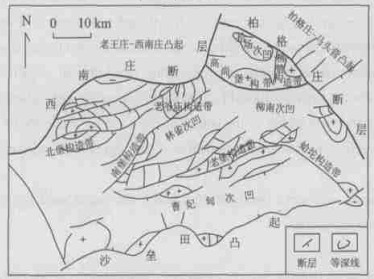
Origin and Evolution of West Slope Breaks of Qingshankou-Yaojia Formation in Northern Songliao Basin
2004, 29(5): 621-624.
Abstract:
The slope-break zone in sedimentary basin is a favorable area for the formation of stratigraphic traps. Based on integrated analysis of geological and geophysical data, origin and evolution of the west slope break of Qingshankou-Yaojia Formation in the northern Songliao basin are discussed. During depositional period of Qingshankou-Yaojia Formation, the western Fuyu first-order slope break and Taikang-Da'an second-order slope break are clearly developed in the west part of northern Songliao basin, the evolution of these slope breaks are controlled by deep buried faults, differential deposition and compaction. The Zhalaiteqi, Nenjiang, and Halahai great buried faults penetrating into lithosphere in west Songliao basin constrain the distribution of the slope break, which also control the distribution of lowstand sandbodies with the combination of multiple deposit sources from the northern Songliao basin, Qiqihar and Yingtai areas during depositional period of Qingshankou-Yaojia Formation. For example, the evolution of the Fuyu first-order slope break is controlled by the Zhalaiteqi, Nenjiang buried faults and Qiqihar and Yingtai sources, and the Taikang-Da'an second-order slope break is controlled by the Halahai buried faults and the northern Songliao basin, Yingtai sources.
The slope-break zone in sedimentary basin is a favorable area for the formation of stratigraphic traps. Based on integrated analysis of geological and geophysical data, origin and evolution of the west slope break of Qingshankou-Yaojia Formation in the northern Songliao basin are discussed. During depositional period of Qingshankou-Yaojia Formation, the western Fuyu first-order slope break and Taikang-Da'an second-order slope break are clearly developed in the west part of northern Songliao basin, the evolution of these slope breaks are controlled by deep buried faults, differential deposition and compaction. The Zhalaiteqi, Nenjiang, and Halahai great buried faults penetrating into lithosphere in west Songliao basin constrain the distribution of the slope break, which also control the distribution of lowstand sandbodies with the combination of multiple deposit sources from the northern Songliao basin, Qiqihar and Yingtai areas during depositional period of Qingshankou-Yaojia Formation. For example, the evolution of the Fuyu first-order slope break is controlled by the Zhalaiteqi, Nenjiang buried faults and Qiqihar and Yingtai sources, and the Taikang-Da'an second-order slope break is controlled by the Halahai buried faults and the northern Songliao basin, Yingtai sources.


2004, 29(5): 625-630.
Abstract:
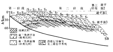
In order to describe the spatial distribution and the size of all facies in fan-delta depositional system, and to compare with the same kind of system, the detailed analysis of crop sequence stratigraphy is taken in the Luanping basin. This basin underwent 5 evolution stages including volcanic irruptions and tectonic subsidences under the actions of episode tectonic movements. Based upon the analysis of high resolution stratigraphic sequence units, high-resolution sequence for the fan-delta system which was developed in late phase. The first flooding surface is taken as the fourth order sequence interface and many recognizable marks of the interface are set up. They also elaborate the principle of dividing fifth order sequence. According to the opinions and principles mentioned above, the high-resolution sequence is subdivided in Luanping basin, into 2 sequences, 15 fourth order sequences, and more than 40 fifth order sequences. In addition, the paper describes the model of fan-delta depositional composition. It dominantly was shallow and coarse fan-delta sedimentary system which was controlled by the synsedimentary fault. The system was composed of 3 depositional associations and 17 genetic facies. Furthermore, the paper generalizes three modes of fan-delta development under the control of tectonic activities. When tectonic movement is equable shallow water and slow fan-delta system is formed. During the basin sabsidence was dominated, the steep and subdeep-shallow water fan-delta system would be formed. When the tectonic movement was dominated by the uplift of the basin margin, the coarse fan-delta system was developed. The conclusions have a strong analogy and referring value to energy resources' exploration and exploitation in East China's similar basin.
In order to describe the spatial distribution and the size of all facies in fan-delta depositional system, and to compare with the same kind of system, the detailed analysis of crop sequence stratigraphy is taken in the Luanping basin. This basin underwent 5 evolution stages including volcanic irruptions and tectonic subsidences under the actions of episode tectonic movements. Based upon the analysis of high resolution stratigraphic sequence units, high-resolution sequence for the fan-delta system which was developed in late phase. The first flooding surface is taken as the fourth order sequence interface and many recognizable marks of the interface are set up. They also elaborate the principle of dividing fifth order sequence. According to the opinions and principles mentioned above, the high-resolution sequence is subdivided in Luanping basin, into 2 sequences, 15 fourth order sequences, and more than 40 fifth order sequences. In addition, the paper describes the model of fan-delta depositional composition. It dominantly was shallow and coarse fan-delta sedimentary system which was controlled by the synsedimentary fault. The system was composed of 3 depositional associations and 17 genetic facies. Furthermore, the paper generalizes three modes of fan-delta development under the control of tectonic activities. When tectonic movement is equable shallow water and slow fan-delta system is formed. During the basin sabsidence was dominated, the steep and subdeep-shallow water fan-delta system would be formed. When the tectonic movement was dominated by the uplift of the basin margin, the coarse fan-delta system was developed. The conclusions have a strong analogy and referring value to energy resources' exploration and exploitation in East China's similar basin.