2004 Vol. 29, No. 6
Display Method:
2004, 29(6): 631-643.
 PDF 1320KB
Abstract:
Understanding the factors that affect the formation and evolution of petroleum-bearing sedimentary basins plays a critical role in the prospecting and exploitation of oil fields. The formation and evolution of the highly-order coastal and on-land petroleum-bearing Cenozoic basins and their bounding mountain ranges in southern California, USA were initiated and controlled by the San Andreas fault system, a large-scale plate boundary transform fault that separates the Pacific plate from the North American plate. The northeast oblique movement of the Pacific plate relative to the North American plate in conjunction with the big bend of the San Andreas fault in southern California produces intense contractional strain across the Transverse Ranges and leads to the formation of a series of fault and fold structures that shape the salient landscape of southern California. For comparison, we have conducted detailed structural analyses on the basin-mountain range systems in the northern Qinghai-Tibet plateau to discuss the role of the Altyn Tagh fault in (1) development of regional contractional stress field; (2) formation of structures and sedimentary basins; (3) generation of structures that facilitate the migration and capture of oil and gas.Resultsshow that the Altyn Tagh fault has played a similar role in the formation of the spectacular basin-mountain systems to that of the San Andreas fault. The oblique convergence of the Qinghai-Tibet terrane relative to the Tarim basin resulted in the formation of transpressional tectonic regime to the southeastern of the Altyn Tagh fault. Such oblique convergence resulted in a series of strike-slip and thrust faults. As a consequence, the areas from the Kunlun Mountains to the Qilian Mountains form spectacular landforms characterized by alternations of basins and mountain ranges. For both cases of the southern California and the northern Qinghai-Tibet plateau, thrust faulting not only provides a viable mechanism for the migration of oil or gas, but also resulted in fault-propagation folds which serve as the favorable capture structure for oil and gas. One of the key factors that generate such a highly organized petroleum-bearing basin-mountain system is oblique convergence induced slip partitioning which results in the dextral horizontal slip along a major strike slip fault and vertical slip along numerous blind or exposed thrust faults.
Understanding the factors that affect the formation and evolution of petroleum-bearing sedimentary basins plays a critical role in the prospecting and exploitation of oil fields. The formation and evolution of the highly-order coastal and on-land petroleum-bearing Cenozoic basins and their bounding mountain ranges in southern California, USA were initiated and controlled by the San Andreas fault system, a large-scale plate boundary transform fault that separates the Pacific plate from the North American plate. The northeast oblique movement of the Pacific plate relative to the North American plate in conjunction with the big bend of the San Andreas fault in southern California produces intense contractional strain across the Transverse Ranges and leads to the formation of a series of fault and fold structures that shape the salient landscape of southern California. For comparison, we have conducted detailed structural analyses on the basin-mountain range systems in the northern Qinghai-Tibet plateau to discuss the role of the Altyn Tagh fault in (1) development of regional contractional stress field; (2) formation of structures and sedimentary basins; (3) generation of structures that facilitate the migration and capture of oil and gas.Resultsshow that the Altyn Tagh fault has played a similar role in the formation of the spectacular basin-mountain systems to that of the San Andreas fault. The oblique convergence of the Qinghai-Tibet terrane relative to the Tarim basin resulted in the formation of transpressional tectonic regime to the southeastern of the Altyn Tagh fault. Such oblique convergence resulted in a series of strike-slip and thrust faults. As a consequence, the areas from the Kunlun Mountains to the Qilian Mountains form spectacular landforms characterized by alternations of basins and mountain ranges. For both cases of the southern California and the northern Qinghai-Tibet plateau, thrust faulting not only provides a viable mechanism for the migration of oil or gas, but also resulted in fault-propagation folds which serve as the favorable capture structure for oil and gas. One of the key factors that generate such a highly organized petroleum-bearing basin-mountain system is oblique convergence induced slip partitioning which results in the dextral horizontal slip along a major strike slip fault and vertical slip along numerous blind or exposed thrust faults.


2004, 29(6): 644-650.
Abstract:
The major progresses of the global tectonics and structural geology in the last 10 years are reviewed. The new global tectonics that emerged three decades ago profoundly changed our understanding of the earth and its evolution. Plate tectonics as a unifying theory of the earth mainly is connected with deformation, seismicity and volcanism within plate boundaries. No comprehensive theory accounts satisfactorily for the driven force of plate motion and mechanism of mantle convection. Many of the problems of plate boundary formation and inter-plate formation remain unanswered. Continental lithosphere is significantly different from oceanic lithosphere in the aspects of composition, thickness and mechanical strength. However, the plate tectonics is not applied to continental tectonics as well. Comprehensive study for rheology of continental crust and the upper mantle is the best way in understanding continental structure and beyond plate tectonics. Rheology is the liaison between geometry and dynamics of continental orogeny. Responses of continental lithosphere to structuring, gravitation and thermodynamics largely depend on its rheological strength. Rheological strength of continental lithosphere is closely connected with stratification and heterogeneity. The pervasive deformation and internal structure of wide continental orogenic belts indicate non-rigid behavior. Continental tectonics and mechanical behavior are controlled by strength that resides mainly in the crust rather than in the mantle. From the view of multi-layering and mechanical heterogeneity of continental lithosphere, it is time to abandon the sandwich model. Facing development trend of earth science system and new thinking of geodynamics, multidisciplinary study on continental structure (orogenic belts) and promptly training outstanding talent is an urgent task.
The major progresses of the global tectonics and structural geology in the last 10 years are reviewed. The new global tectonics that emerged three decades ago profoundly changed our understanding of the earth and its evolution. Plate tectonics as a unifying theory of the earth mainly is connected with deformation, seismicity and volcanism within plate boundaries. No comprehensive theory accounts satisfactorily for the driven force of plate motion and mechanism of mantle convection. Many of the problems of plate boundary formation and inter-plate formation remain unanswered. Continental lithosphere is significantly different from oceanic lithosphere in the aspects of composition, thickness and mechanical strength. However, the plate tectonics is not applied to continental tectonics as well. Comprehensive study for rheology of continental crust and the upper mantle is the best way in understanding continental structure and beyond plate tectonics. Rheology is the liaison between geometry and dynamics of continental orogeny. Responses of continental lithosphere to structuring, gravitation and thermodynamics largely depend on its rheological strength. Rheological strength of continental lithosphere is closely connected with stratification and heterogeneity. The pervasive deformation and internal structure of wide continental orogenic belts indicate non-rigid behavior. Continental tectonics and mechanical behavior are controlled by strength that resides mainly in the crust rather than in the mantle. From the view of multi-layering and mechanical heterogeneity of continental lithosphere, it is time to abandon the sandwich model. Facing development trend of earth science system and new thinking of geodynamics, multidisciplinary study on continental structure (orogenic belts) and promptly training outstanding talent is an urgent task.


2004, 29(6): 651-660.
Abstract:
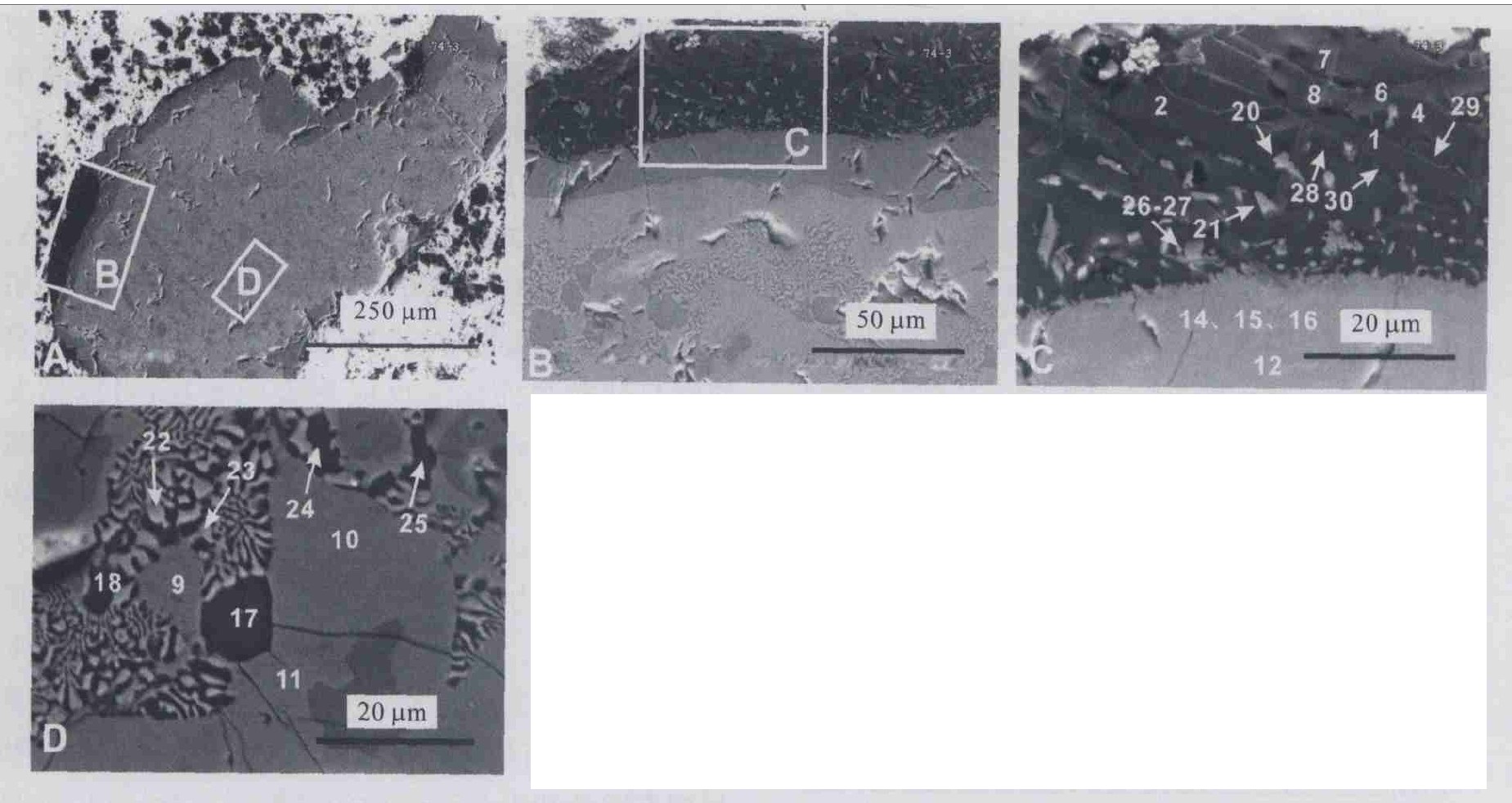
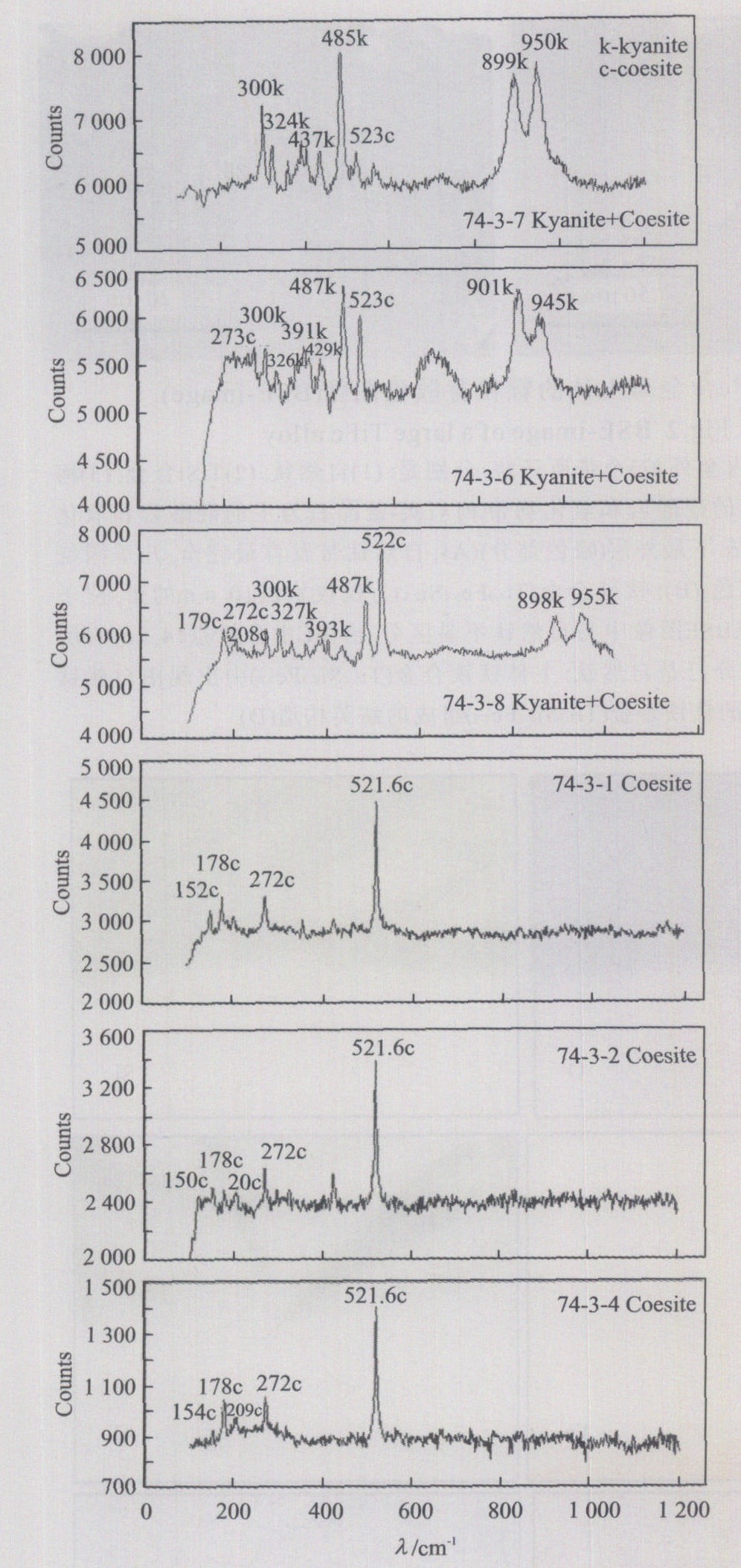
Coesite and kyanite are new discovery from the podiform chromitite in the Luobusha ophiolite, which is located (about) 200 km southeast of Lhasa, Tibet, and marks the locus of collision between the Indian and Eurasian plates. Coesite-kyanite crystals are acicular and individuals are about (20-40) μm× (4-6) μm in size, forming a 30-50 μm wide rim (around) a 0.7 mm×0.5 mm TiFe alloy. Besides the coesite-kyanite rim, the TiFe alloy core is surrounded by a TiSi outer zone of about 10 μm width, and a native Ti inner zone of about 20-70 μm width. Ti-Mg-K-Na-Ca oxide crystals and Si-(rutile) occur as interstitial materials within the framework formed by coesite and kyanite. Within the TiFe alloy core are some small grains of native Ti and relatively low-Ti TiFe alloy, constituting a myrmekitic texture. The amount of Si, Al and O shows a decreasing trend from rim to core, which suggests that a chemical reaction occurred at the rim of the TiFe alloy. During this reaction new minerals formed with a symplektic texture. The regular variation from native Ti through TiSi to coesite-kyanite and oxide aggregates suggests that the series of minerals were formed by a reaction between native Ti and some silicates, under high pressure and temperature. This reaction probably occurred during the upwelling of a plume which carried TiFe alloy and other minerals from the deep mantle, suggesting that the Luobusha coesite formed during a decrease in pressure, which is in contrast with the coesite formed by increasing pressure in a convergent margin.
Coesite and kyanite are new discovery from the podiform chromitite in the Luobusha ophiolite, which is located (about) 200 km southeast of Lhasa, Tibet, and marks the locus of collision between the Indian and Eurasian plates. Coesite-kyanite crystals are acicular and individuals are about (20-40) μm× (4-6) μm in size, forming a 30-50 μm wide rim (around) a 0.7 mm×0.5 mm TiFe alloy. Besides the coesite-kyanite rim, the TiFe alloy core is surrounded by a TiSi outer zone of about 10 μm width, and a native Ti inner zone of about 20-70 μm width. Ti-Mg-K-Na-Ca oxide crystals and Si-(rutile) occur as interstitial materials within the framework formed by coesite and kyanite. Within the TiFe alloy core are some small grains of native Ti and relatively low-Ti TiFe alloy, constituting a myrmekitic texture. The amount of Si, Al and O shows a decreasing trend from rim to core, which suggests that a chemical reaction occurred at the rim of the TiFe alloy. During this reaction new minerals formed with a symplektic texture. The regular variation from native Ti through TiSi to coesite-kyanite and oxide aggregates suggests that the series of minerals were formed by a reaction between native Ti and some silicates, under high pressure and temperature. This reaction probably occurred during the upwelling of a plume which carried TiFe alloy and other minerals from the deep mantle, suggesting that the Luobusha coesite formed during a decrease in pressure, which is in contrast with the coesite formed by increasing pressure in a convergent margin.


2004, 29(6): 661-666.
Abstract:
Different orogenic belts are composed of different tectonic facies units. The division of tectonic facies reveals the basin skeleton and the evolution rules of an orogenic belt. In 1∶250 000 geological mapping of the Donggi Conag Hu area in the East Kunlun orogenic belt, considering the timing evolution and tectonic setting as the main clues, and according to the tectono-paleogeography, basin type and matter construction type in different evolution stages, we divide the tectonic facies into seven big facies including 21 small facies, such as extensional oceanic ridge facies, offset (extensional) trough facies, carbonate seamount facies, carbonate platform facies, abyssal plain facies, continental sliver facies, foreland basin facies, molasses basin facies and so on. From this research we have produced a 1∶250 000 tectonic facies diagram of the Donggi Conag Hu area, and diagrams which display the orogenic processes and tectonic facies evolution. The application of tectonic facies in geological mapping deepens the study of the spatial relation of strata units and basin filling sequences during orogenic mapping, and we reveal the forming, substance composition and evolution processes of orogenic belts in the east part of the East Kunlun orogenic belt in detail.
Different orogenic belts are composed of different tectonic facies units. The division of tectonic facies reveals the basin skeleton and the evolution rules of an orogenic belt. In 1∶250 000 geological mapping of the Donggi Conag Hu area in the East Kunlun orogenic belt, considering the timing evolution and tectonic setting as the main clues, and according to the tectono-paleogeography, basin type and matter construction type in different evolution stages, we divide the tectonic facies into seven big facies including 21 small facies, such as extensional oceanic ridge facies, offset (extensional) trough facies, carbonate seamount facies, carbonate platform facies, abyssal plain facies, continental sliver facies, foreland basin facies, molasses basin facies and so on. From this research we have produced a 1∶250 000 tectonic facies diagram of the Donggi Conag Hu area, and diagrams which display the orogenic processes and tectonic facies evolution. The application of tectonic facies in geological mapping deepens the study of the spatial relation of strata units and basin filling sequences during orogenic mapping, and we reveal the forming, substance composition and evolution processes of orogenic belts in the east part of the East Kunlun orogenic belt in detail.


2004, 29(6): 667-673.
Abstract:
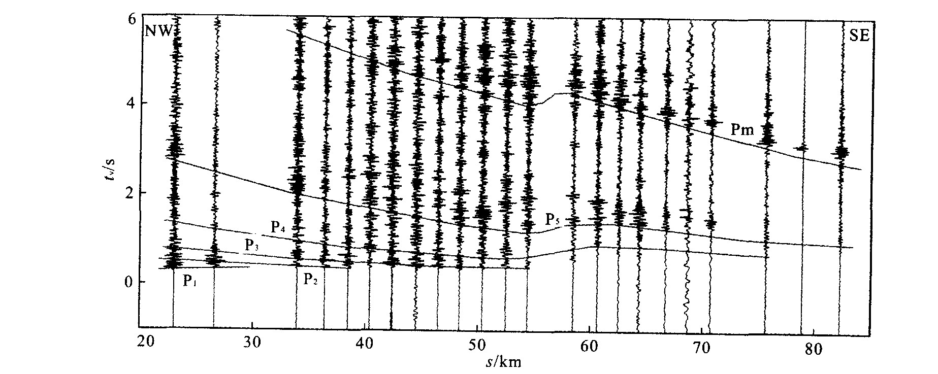
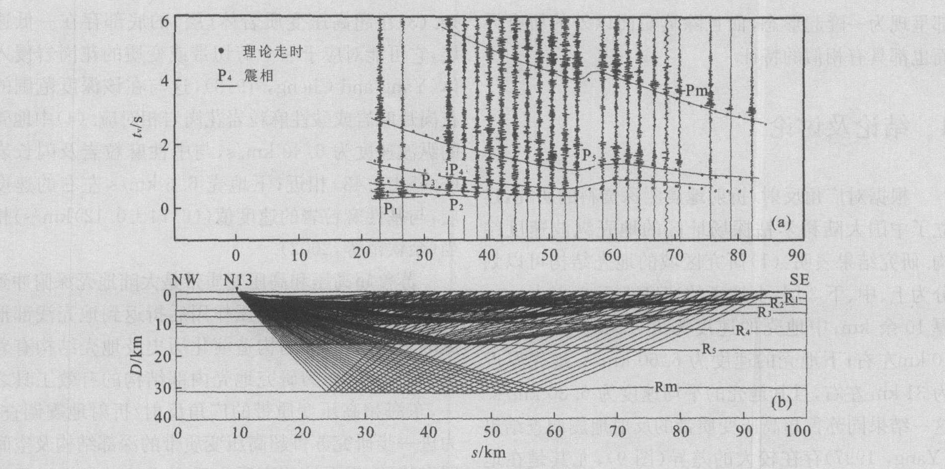
In order to study the deep structure, spatial tectonic characteristics and the dynamic process for the Dabie-Sulu ultral-high metamorphic belt, a wide-angle reflection/refraction seismic survey was conducted in the Chinese Continental Scientific Drilling (CCSD) site. The crustal velocity structure beneath the CCSD site has been established based on wide-angle seismic reflection/refraction data acquired at the site. According to the results, the crust beneath CCSD is composed of three layers: the upper, middle and lower crust, with velocities of < 6.20 km/s, 6.40 km/s, and 6.60 km/s, and a thickness of ~10 km, ~10 km, and ~12 km respectively. The crust thickness is 31 km around with an average velocity of 6.30 km/s. However, the reversed velocity in the upper crust implies an ultrahigh-pressure metamorphic (UHPM) layer (body) with a shape of uplift beneath or near the CCSD site.
In order to study the deep structure, spatial tectonic characteristics and the dynamic process for the Dabie-Sulu ultral-high metamorphic belt, a wide-angle reflection/refraction seismic survey was conducted in the Chinese Continental Scientific Drilling (CCSD) site. The crustal velocity structure beneath the CCSD site has been established based on wide-angle seismic reflection/refraction data acquired at the site. According to the results, the crust beneath CCSD is composed of three layers: the upper, middle and lower crust, with velocities of < 6.20 km/s, 6.40 km/s, and 6.60 km/s, and a thickness of ~10 km, ~10 km, and ~12 km respectively. The crust thickness is 31 km around with an average velocity of 6.30 km/s. However, the reversed velocity in the upper crust implies an ultrahigh-pressure metamorphic (UHPM) layer (body) with a shape of uplift beneath or near the CCSD site.


2004, 29(6): 674-684.
Abstract:
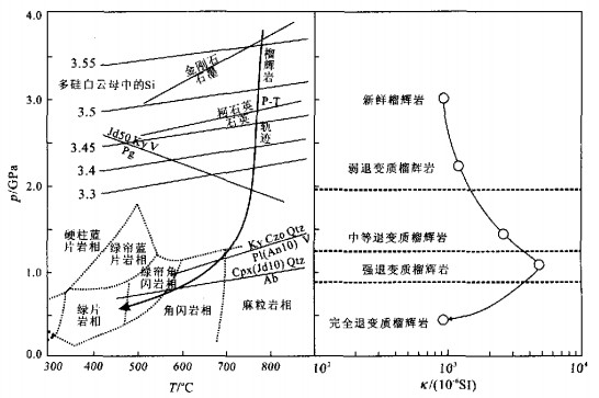
The magnetic susceptibility and anisotropy of the ultrahigh-pressure (UHP) eclogite from Chinese Continent Scientific Drilling (CCSD) 100-2 000 m mainhole and their relationship with petrology and mineralogy are systematically investigated. The results show that eclogites of different retrogressions have specific magnetic characters. Fresh to weakly retrograded eclogites which correspond to UHP eclogite facies have relatively low magnetic susceptibility (κ=1.4×10⁻³ SI) and low anisotropy (Pj=1.09), the paramagnetic mineral omphacite and garnet being the principal carriers. For moderately to strongly retrograded eclogites corresponding to amphibolite facies, because of the formation of magnetite and ilmenite by retrogression, the magnetic susceptibility and anisotropy increases up to κ=5.1×10⁻³ SI and Pj=1.20. However, for the totally retrograded eclogites corresponding with epidote amphibolite to greenschist facies, magnetite disappears while ilmenite and titanomagnetite changes to sphene. Thus the magnetic susceptibility and anisotropy reduces to κ=1.3×10⁻³ SI and Pj=1.08, respectively. This research provides fundamental data and constrains for the interpretation of geophysical magnetic surveying on the UHP metamorphic terranes. Furthermore, the magnetic characters show us the insight into the identification of the peak metamorphic rocks during subduction and the degree of retrogression during exhumation.
The magnetic susceptibility and anisotropy of the ultrahigh-pressure (UHP) eclogite from Chinese Continent Scientific Drilling (CCSD) 100-2 000 m mainhole and their relationship with petrology and mineralogy are systematically investigated. The results show that eclogites of different retrogressions have specific magnetic characters. Fresh to weakly retrograded eclogites which correspond to UHP eclogite facies have relatively low magnetic susceptibility (κ=1.4×10⁻³ SI) and low anisotropy (Pj=1.09), the paramagnetic mineral omphacite and garnet being the principal carriers. For moderately to strongly retrograded eclogites corresponding to amphibolite facies, because of the formation of magnetite and ilmenite by retrogression, the magnetic susceptibility and anisotropy increases up to κ=5.1×10⁻³ SI and Pj=1.20. However, for the totally retrograded eclogites corresponding with epidote amphibolite to greenschist facies, magnetite disappears while ilmenite and titanomagnetite changes to sphene. Thus the magnetic susceptibility and anisotropy reduces to κ=1.3×10⁻³ SI and Pj=1.08, respectively. This research provides fundamental data and constrains for the interpretation of geophysical magnetic surveying on the UHP metamorphic terranes. Furthermore, the magnetic characters show us the insight into the identification of the peak metamorphic rocks during subduction and the degree of retrogression during exhumation.


2004, 29(6): 685-690.
Abstract:
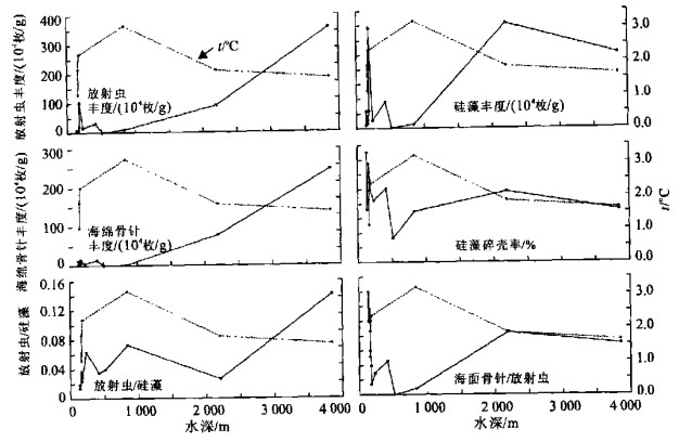
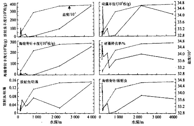
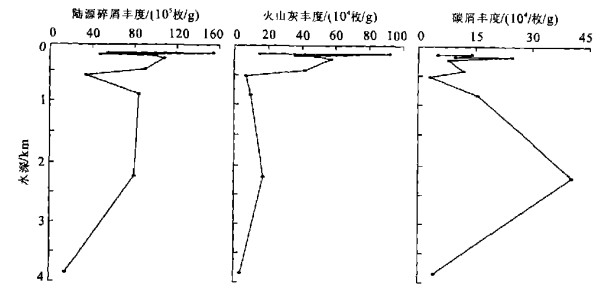
Based on the quantitative studies of siliceous microorganisms and terrestrial detritus in 12 surface sediment samples, which were recovered by the First Chinese National Arctic Expedition team, in the Bering Sea, it goes without saying that diatom abundance is dominant within the microorganisms which consists of diatoms, radiolarians and sponge spicules. The relationship between the microorganisms and environmental control factors, for example, water depth, temperature and salinity are analyzed and discussed. It is evident that their abundance change and preservation are associated closely with these environmental control factors, and high surface nutrient and productivity controlled by the variations of large scale seasonal climate and input of terrestrial detritus. This investigation is very significant for the further studies on paleoclimate and paleoceanography in the Bering Sea.
Based on the quantitative studies of siliceous microorganisms and terrestrial detritus in 12 surface sediment samples, which were recovered by the First Chinese National Arctic Expedition team, in the Bering Sea, it goes without saying that diatom abundance is dominant within the microorganisms which consists of diatoms, radiolarians and sponge spicules. The relationship between the microorganisms and environmental control factors, for example, water depth, temperature and salinity are analyzed and discussed. It is evident that their abundance change and preservation are associated closely with these environmental control factors, and high surface nutrient and productivity controlled by the variations of large scale seasonal climate and input of terrestrial detritus. This investigation is very significant for the further studies on paleoclimate and paleoceanography in the Bering Sea.


2004, 29(6): 691-696.
Abstract:
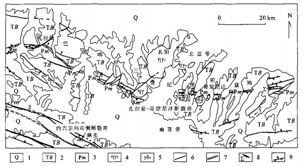
A branching ocean basin, to be known as the Kuhai-Saishitang branching ocean, has been discovered in the area between the Kunlun and Qinling Mountains, China. The Kuhai-Saishitang branching ocean was discovered by detailed mapping and analysis, which revealed an ophiolite complex in a north-north-east orientated branching basin connected to the (Buqingshan) -Animaqing ocean. The basin includes Xueqiong and Cuozama MOR-type ophiolites which indicate that spreading of the basin took place in the Late Devonian-Carboniferous. This is supported by an Ar40/Ar39 age for the ophiolite complex/compound (which compound?) of (368.6±1.4) Ma, which is contemporaneous with the formation of the Buqingshan- (Animaqing) ocean. The ophiolite present indicates that the oceanic lithosphere of the Kuhai-Saishitang basin formed in a small, immature ocean basin. One behavior of expansion is tectonic hot event heavy recorded in cracking block slice and crystal base, for instance, amphibole 40Ar/39Ar low temperature plateau age of amphibolite in Longtong area is (358.9±3.2) Ma, biotite 40Ar/39Ar plateau age of mica-quartz tectonic schist in Yangqu area is (387.3±2.3) Ma, Rb-Sr isochrone age of biotite plagioclase-gneiss in Kuhai area is (336±2.2) Ma, amphibole 40Ar/39Ar low temperature plateau age of amphibolite in Zanaheruo is (376.9±0.9) Ma, these ages reflect cracking time limit. The pyroxene 39Ar/40Ar plateau age of diabase in cracking slice in Lalongwa is 398.4 Ma which reflects that expansion began in the Devonian. There is evidence of the formation of a volcanic island arc in the Early Permian (264 Ma) and subduction occurring along the south-east edge of the (Chaidamu) minor continental block in the Early-Middle Permian (267 Ma). The subduction is marked by the presence of subduction-type granite which was altered by middle-high pressure metamorphism as the strength of the subduction increased. Also associated with the subduction zone is a hyperplasia mélange wedge. In the Late Permian, the interaction of the Chaidamu and Ruoergai minor continental blocks caused arc-continent collision which resulted in the closure of the Kuhai-Saishitang branching ocean and the formation of collision-type mica-containing granite in the Cuoka area and the deposition of syn-collision molasse sediments of the Gequ Group.
A branching ocean basin, to be known as the Kuhai-Saishitang branching ocean, has been discovered in the area between the Kunlun and Qinling Mountains, China. The Kuhai-Saishitang branching ocean was discovered by detailed mapping and analysis, which revealed an ophiolite complex in a north-north-east orientated branching basin connected to the (Buqingshan) -Animaqing ocean. The basin includes Xueqiong and Cuozama MOR-type ophiolites which indicate that spreading of the basin took place in the Late Devonian-Carboniferous. This is supported by an Ar40/Ar39 age for the ophiolite complex/compound (which compound?) of (368.6±1.4) Ma, which is contemporaneous with the formation of the Buqingshan- (Animaqing) ocean. The ophiolite present indicates that the oceanic lithosphere of the Kuhai-Saishitang basin formed in a small, immature ocean basin. One behavior of expansion is tectonic hot event heavy recorded in cracking block slice and crystal base, for instance, amphibole 40Ar/39Ar low temperature plateau age of amphibolite in Longtong area is (358.9±3.2) Ma, biotite 40Ar/39Ar plateau age of mica-quartz tectonic schist in Yangqu area is (387.3±2.3) Ma, Rb-Sr isochrone age of biotite plagioclase-gneiss in Kuhai area is (336±2.2) Ma, amphibole 40Ar/39Ar low temperature plateau age of amphibolite in Zanaheruo is (376.9±0.9) Ma, these ages reflect cracking time limit. The pyroxene 39Ar/40Ar plateau age of diabase in cracking slice in Lalongwa is 398.4 Ma which reflects that expansion began in the Devonian. There is evidence of the formation of a volcanic island arc in the Early Permian (264 Ma) and subduction occurring along the south-east edge of the (Chaidamu) minor continental block in the Early-Middle Permian (267 Ma). The subduction is marked by the presence of subduction-type granite which was altered by middle-high pressure metamorphism as the strength of the subduction increased. Also associated with the subduction zone is a hyperplasia mélange wedge. In the Late Permian, the interaction of the Chaidamu and Ruoergai minor continental blocks caused arc-continent collision which resulted in the closure of the Kuhai-Saishitang branching ocean and the formation of collision-type mica-containing granite in the Cuoka area and the deposition of syn-collision molasse sediments of the Gequ Group.


2004, 29(6): 697-702.
Abstract:
A series of Mg/Ca ratios of planktonic foraminifera shell Globigerinoides sacculifer in two cores in the NE Indian Ocean were measured by ICP-MS after careful cleaning and dissolving. The results show Mg/Ca ratio and δ18O change accordingly. The Mg/Ca ratio increases with the rise of temperature. This study demonstrates Mg/Ca ratio of planktonic foraminifera shell may serve as a proxy for the past sea surface temperatures (SST).The formula Mg/Ca=0.471 7exp (0.082 5*SST) was applied to calculating and the result shows that in low and middle latitudes, including the NE Indian Ocean, the difference of SST between LGM and the Holocene is about 4 ℃ which is higher than the 2 ℃ estimated by CLIMAP.
A series of Mg/Ca ratios of planktonic foraminifera shell Globigerinoides sacculifer in two cores in the NE Indian Ocean were measured by ICP-MS after careful cleaning and dissolving. The results show Mg/Ca ratio and δ18O change accordingly. The Mg/Ca ratio increases with the rise of temperature. This study demonstrates Mg/Ca ratio of planktonic foraminifera shell may serve as a proxy for the past sea surface temperatures (SST).The formula Mg/Ca=0.471 7exp (0.082 5*SST) was applied to calculating and the result shows that in low and middle latitudes, including the NE Indian Ocean, the difference of SST between LGM and the Holocene is about 4 ℃ which is higher than the 2 ℃ estimated by CLIMAP.


2004, 29(6): 703-710.
Abstract:
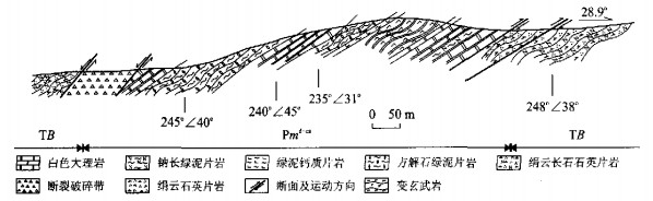
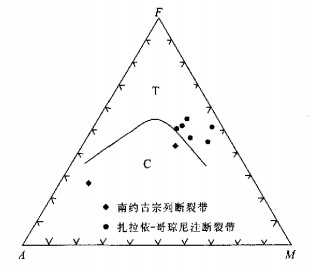
Permian volcanic rocks are developed in fault nip blocks of the Zanayi-Geqiongniwa and Yueguzonglie fault zones in the Bayan Hala turbidite basin, east Kunlun area. Volcanic rocks are output in tectonic slices. The volcanic rock assemblage in the Zanayi-Geqiongniwa fault zone is mainly basalts and basaltic andesites, some with the pillow structure. The SiO2 content of the volcanic rocks is uniform, the TiO2 content is higher and the ALK content is lower. The rock type is mainly tholeiitic basalt. REE distribution patterns of which are LREE-rich type and consistent with those of ocean island type volcanic rocks, the large ion lithophile elements of volcanic rocks is more enrichment, HFS elements and HREE of them is flatten. The characteristics of REE, trace elements and tectonic setting distinguishing reveal that the volcanic rocks of the Zanayi-Geqiongniwa fault belt were formed mainly in an ocean island tectonic setting, while some were formed in a middle ocean ridge tectonic setting. The volcanic rock assemblage in the Yueguzonglie fault zone consists of basalt and basaltic andesite. Their SiO2 content is higher, while TiO2 content is less than one percent. The rock types are calc-alkaline series. REE distribution patterns of basaltic andesite are consistent with that of the volcanic rocks in the Zanayi-Geqiongniwa fault zones, that of dacite is high rich in LREE and consistent with island arc high-K andesite. Tectonic setting distinguishing reveals that the volcanic rocks of the Yueguzonglie fault belt are formed in island arc tectonic setting. According to the differing contents of the volcanic rocks and clast from the Bayan Hala Group beside the Zanayi-Geqiongniwa fault belt, we can divide the Bayan Hala turbidite basin into north subbelt and south subbelt.
Permian volcanic rocks are developed in fault nip blocks of the Zanayi-Geqiongniwa and Yueguzonglie fault zones in the Bayan Hala turbidite basin, east Kunlun area. Volcanic rocks are output in tectonic slices. The volcanic rock assemblage in the Zanayi-Geqiongniwa fault zone is mainly basalts and basaltic andesites, some with the pillow structure. The SiO2 content of the volcanic rocks is uniform, the TiO2 content is higher and the ALK content is lower. The rock type is mainly tholeiitic basalt. REE distribution patterns of which are LREE-rich type and consistent with those of ocean island type volcanic rocks, the large ion lithophile elements of volcanic rocks is more enrichment, HFS elements and HREE of them is flatten. The characteristics of REE, trace elements and tectonic setting distinguishing reveal that the volcanic rocks of the Zanayi-Geqiongniwa fault belt were formed mainly in an ocean island tectonic setting, while some were formed in a middle ocean ridge tectonic setting. The volcanic rock assemblage in the Yueguzonglie fault zone consists of basalt and basaltic andesite. Their SiO2 content is higher, while TiO2 content is less than one percent. The rock types are calc-alkaline series. REE distribution patterns of basaltic andesite are consistent with that of the volcanic rocks in the Zanayi-Geqiongniwa fault zones, that of dacite is high rich in LREE and consistent with island arc high-K andesite. Tectonic setting distinguishing reveals that the volcanic rocks of the Yueguzonglie fault belt are formed in island arc tectonic setting. According to the differing contents of the volcanic rocks and clast from the Bayan Hala Group beside the Zanayi-Geqiongniwa fault belt, we can divide the Bayan Hala turbidite basin into north subbelt and south subbelt.


2004, 29(6): 711-715.
Abstract:
Use different expressions of the various oxides and relevant ratio of lithochemistry in continental basin, this paper discusses the forming climate, water body, depositional system and base level characteristics of level Ⅳ sequence in Xiufeng Formation of upper Heilongjiang basin. Fe2O3, Fe3+/Fe2+, K2O, Na2O, etc. decreased gradually from bottom to middle in level Ⅳ sequence of Xiufeng Formation; MnO, FeO, MgO, LOS, etc. increased gradually; from middle to top, Fe2O3, K2O, Na2O, etc. increased gradually, MnO, FeO, etc. decreased. The symmetrical cycle characteristics show that the base level of the middle period is from a deep water body and a damp climate, changing to a shallow water body and dry climate in level Ⅳ sequence of Xiufeng Formation. This study provides a new thought for high frequency sequence division of continental basin.
Use different expressions of the various oxides and relevant ratio of lithochemistry in continental basin, this paper discusses the forming climate, water body, depositional system and base level characteristics of level Ⅳ sequence in Xiufeng Formation of upper Heilongjiang basin. Fe2O3, Fe3+/Fe2+, K2O, Na2O, etc. decreased gradually from bottom to middle in level Ⅳ sequence of Xiufeng Formation; MnO, FeO, MgO, LOS, etc. increased gradually; from middle to top, Fe2O3, K2O, Na2O, etc. increased gradually, MnO, FeO, etc. decreased. The symmetrical cycle characteristics show that the base level of the middle period is from a deep water body and a damp climate, changing to a shallow water body and dry climate in level Ⅳ sequence of Xiufeng Formation. This study provides a new thought for high frequency sequence division of continental basin.


2004, 29(6): 716-732.
Abstract:
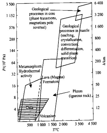
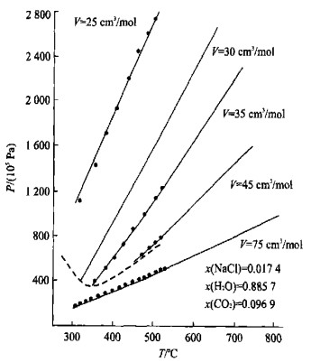
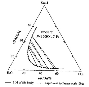
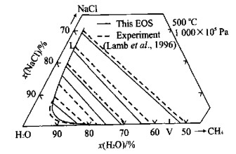
Methodsfor predicting the thermodynamic properties of natural fluids over a large range of concentration, temperature and pressure are presented. With careful choice of phenomenology and parameterization, predictions can be made with accuracies similar to the experimental data.Resultspresented for the NaCl-CO2-CH4-H2O system suggest that these modeling methods can be used to extrapolate experimental measurements to high pressure and temperature regions difficult to access by experimental methods. For species such as CH4 and CO2, which are nonpolar and weakly interacting, a corresponding states representation yields results that are highly accurate and depend on only two temperature and pressure independent parameters. Predictions with such models of fluid/fluid coexistence at high temperature and pressures are within experimental accuracy. The role of molecular dynamics and Monte Carlo simulations in developing thermodynamic representations of natural system are discussed. For closed shell and nonpolar systems, simulation results agree very well with experimental data. Polar systems (H2O) at sufficiently high temperatures are also well described. On the other hand, the simulations for polar systems at low temperatures yield results only in qualitative agreement with data. Efforts to improve simulation methods for these systems are in progress.
Methodsfor predicting the thermodynamic properties of natural fluids over a large range of concentration, temperature and pressure are presented. With careful choice of phenomenology and parameterization, predictions can be made with accuracies similar to the experimental data.Resultspresented for the NaCl-CO2-CH4-H2O system suggest that these modeling methods can be used to extrapolate experimental measurements to high pressure and temperature regions difficult to access by experimental methods. For species such as CH4 and CO2, which are nonpolar and weakly interacting, a corresponding states representation yields results that are highly accurate and depend on only two temperature and pressure independent parameters. Predictions with such models of fluid/fluid coexistence at high temperature and pressures are within experimental accuracy. The role of molecular dynamics and Monte Carlo simulations in developing thermodynamic representations of natural system are discussed. For closed shell and nonpolar systems, simulation results agree very well with experimental data. Polar systems (H2O) at sufficiently high temperatures are also well described. On the other hand, the simulations for polar systems at low temperatures yield results only in qualitative agreement with data. Efforts to improve simulation methods for these systems are in progress.


2004, 29(6): 733-743.
Abstract:
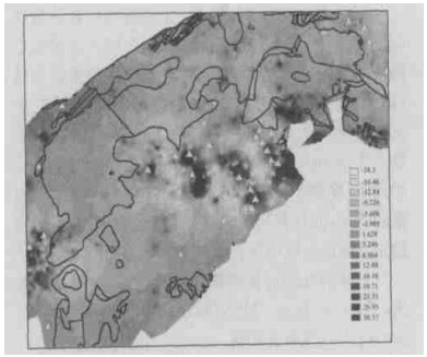
Scale invariance, including self-similarity (isotropic), self-affinity (stratification), and generalized self-similarity (anisotropy), is a common property of spatial patterns generated from various geological processes and events. Scale invariance can be described by means of fractal and multifractal models. Quantifying the scale invariance properties of spatial patterns may provide a powerful tool for characterizing geological processes and events. For example, the clustering distribution of hydrothermal mineral deposits can be characterized by means of local singularity analysis. The identification of distinct generalized self-similarity in the Fourier domain can be used to decompose spatial patterns into separate components such as anomalies from background patterns. The current paper introduces a number of relevant multifractal models and methods, including a linear model for generalized scale invariance (GSI); a spectrum-area method (S-A) for anomaly separation; a local singularity analysis method; and methods for predicting undiscovered mineral deposits on the basis of fractal and multifractal properties. Some of these methods have been applied in various case studies. The case study introduced in the current paper demonstrates the application of S-A anomaly separation and local anomaly enhancement in analyzing lake sediment geochemical data (As, Pb, Zn and Cu) for gold mineral resource prediction. It has been shown that the areas delineated by a strong singularity in As, Pb, Zn and Cu are spatially associated with the location of known gold mineral deposits.
Scale invariance, including self-similarity (isotropic), self-affinity (stratification), and generalized self-similarity (anisotropy), is a common property of spatial patterns generated from various geological processes and events. Scale invariance can be described by means of fractal and multifractal models. Quantifying the scale invariance properties of spatial patterns may provide a powerful tool for characterizing geological processes and events. For example, the clustering distribution of hydrothermal mineral deposits can be characterized by means of local singularity analysis. The identification of distinct generalized self-similarity in the Fourier domain can be used to decompose spatial patterns into separate components such as anomalies from background patterns. The current paper introduces a number of relevant multifractal models and methods, including a linear model for generalized scale invariance (GSI); a spectrum-area method (S-A) for anomaly separation; a local singularity analysis method; and methods for predicting undiscovered mineral deposits on the basis of fractal and multifractal properties. Some of these methods have been applied in various case studies. The case study introduced in the current paper demonstrates the application of S-A anomaly separation and local anomaly enhancement in analyzing lake sediment geochemical data (As, Pb, Zn and Cu) for gold mineral resource prediction. It has been shown that the areas delineated by a strong singularity in As, Pb, Zn and Cu are spatially associated with the location of known gold mineral deposits.


2004, 29(6): 745-752.
Abstract:
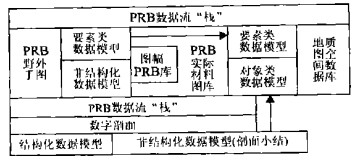
Based on the third generation geography database model and the point-routing-boundary (PRB) data model, this paper explains that the PRB data stream stack is the inherited and transferred foundation of data models in different digital mapping stages. This is done by using the relationship between the PRB data stream stack and different-stage data model. It shows that the date model of the database, which includes the final-interpretable results, can inherit from the integration of the different-stage structure and non-structure data model, and clarifies that the inherited and transferred technique of spatial and no spatial attributes have been implemented by using inter-operation between object class and feature class. At the same time, in terms of the data molding principle of the integrative describing geological map, organizing data and storing data, it is concluded that the PRB data model of the PRB geological map spatial database is composed of seventeen basic feature classes, six object classes and eight synthetic feature classes. This paper also defines and discusses some elements of the PRB data model, including entity names, feature and object class coding, spatial data types, entity relationships, primary and subordinate key names, coding of feature classes notation, and entity attributes.
Based on the third generation geography database model and the point-routing-boundary (PRB) data model, this paper explains that the PRB data stream stack is the inherited and transferred foundation of data models in different digital mapping stages. This is done by using the relationship between the PRB data stream stack and different-stage data model. It shows that the date model of the database, which includes the final-interpretable results, can inherit from the integration of the different-stage structure and non-structure data model, and clarifies that the inherited and transferred technique of spatial and no spatial attributes have been implemented by using inter-operation between object class and feature class. At the same time, in terms of the data molding principle of the integrative describing geological map, organizing data and storing data, it is concluded that the PRB data model of the PRB geological map spatial database is composed of seventeen basic feature classes, six object classes and eight synthetic feature classes. This paper also defines and discusses some elements of the PRB data model, including entity names, feature and object class coding, spatial data types, entity relationships, primary and subordinate key names, coding of feature classes notation, and entity attributes.

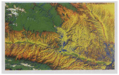
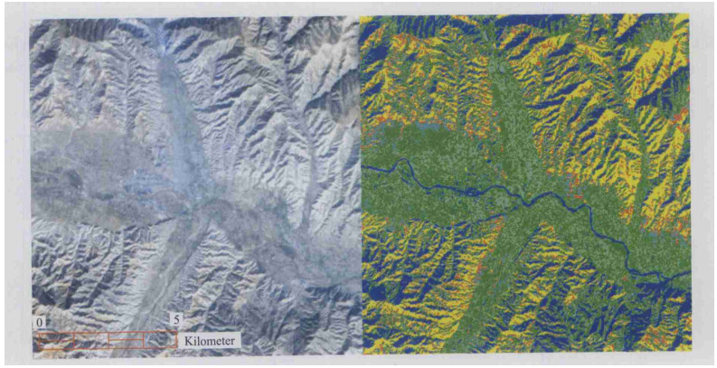
2004, 29(6): 753-758.
Abstract:
The decision tree is an effective and accurate method in remote sensing classification. We use this method to classify the remote sensing data-ETM+ (enhanced thematic mapper plus), which covers most of the area of Minhe County, Qinghai Province. The acquisition date of ETM+ is October 29, 1999. We get digital elevation model (DEM) data from (1:) 250 000 topography map of Minhe area. The format of DEM is MapInfo exchange format *.mif which converted to (geography) coordinate. After primary treatment of the raw data, the DEM data is derived from the contour line. The ETM+ scenes are rectified using the DEM and sun-illumination model. NDVI and other three indexes from Tasseled Cap transform were calculated from RS data. All these indexes are stacked with five RS bands. The target objects are selected. The sampling of the target object is based on visual observation. First, false color composed imagery is essential, and the sampling process is interactive. The digital information of the target object is derived from the program, which compiled by IDL. The decision tree model was calculated by Clementine7.2 software suite. About 10% raw data were used to validate the accuracy of the model. Meantime others were used to build the model. Ten iterative numbers and 75% trim radio are the suit parameters for this model. Then we get the most suitable layer and numerical value for distinguishing different target objects. For instance, distinguishing Tertiary red clastic and loess's best layer is band 1 and band 3. In the next step, we import the model to Envi 4.0 and classify the raw data into different target objects. After some basic treatments, for example clump and (assign) class color, we get the final result map. The map is contrasted with 1:250 000 geology map of Minhe area and achieved the accuracy of classification. The result is that the decision tree method is better than traditional classify methods. Another conclusion is that the rules from decision tree could help geologists to gain a appropriate geological conclusion.
The decision tree is an effective and accurate method in remote sensing classification. We use this method to classify the remote sensing data-ETM+ (enhanced thematic mapper plus), which covers most of the area of Minhe County, Qinghai Province. The acquisition date of ETM+ is October 29, 1999. We get digital elevation model (DEM) data from (1:) 250 000 topography map of Minhe area. The format of DEM is MapInfo exchange format *.mif which converted to (geography) coordinate. After primary treatment of the raw data, the DEM data is derived from the contour line. The ETM+ scenes are rectified using the DEM and sun-illumination model. NDVI and other three indexes from Tasseled Cap transform were calculated from RS data. All these indexes are stacked with five RS bands. The target objects are selected. The sampling of the target object is based on visual observation. First, false color composed imagery is essential, and the sampling process is interactive. The digital information of the target object is derived from the program, which compiled by IDL. The decision tree model was calculated by Clementine7.2 software suite. About 10% raw data were used to validate the accuracy of the model. Meantime others were used to build the model. Ten iterative numbers and 75% trim radio are the suit parameters for this model. Then we get the most suitable layer and numerical value for distinguishing different target objects. For instance, distinguishing Tertiary red clastic and loess's best layer is band 1 and band 3. In the next step, we import the model to Envi 4.0 and classify the raw data into different target objects. After some basic treatments, for example clump and (assign) class color, we get the final result map. The map is contrasted with 1:250 000 geology map of Minhe area and achieved the accuracy of classification. The result is that the decision tree method is better than traditional classify methods. Another conclusion is that the rules from decision tree could help geologists to gain a appropriate geological conclusion.