2005 Vol. 30, No. 1
Display Method:
2005, 30(1): 1-18.
 PDF 965KB
Abstract:
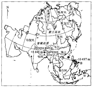
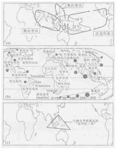
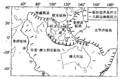
Of the existing continents, Asia experienced the most significant deformation during the Cenozoic. From the Cretaceous to early Paleogene, Asia was smaller and "slimmer" compared with the present continent. After the India-Asia collision in the Eocene, Asia significantly enlarged its size and increased its altitude. The west-tilting topography of East Asia was reversed with the uplift of the Tibetan plateau and the opening of marginal seas, resulting in an Asian fluvial system radiating from the uplifted center of the continent. Plateau uplift may have promoted the establishment and growth of the Arctic ice-sheet not only by the alteration of atmospheric circulation and enhancement of weathering, but also by the formation of north-flowing Siberian rivers, which provided the Arctic Ocean with freshwater run-off. The Cenozoic deformation of Asia was also responsible for the initiation of the Asian monsoon system during the early Miocene and its further strengthening at ~8 Ma and ~3 Ma. The formation of a series of seas fringing the East Asian margin has changed the material and energy flux between the Asian continent and Pacific Ocean. The western Pacific boundary currents flowing through the marginal seas are highly sensitive to eustatic and tectonic changes. During low sea-level stands caused by glaciation, the boundary currents flowed outside the marginal seas and reduced the heat and humidity supply from the ocean to the continent. Today, the most active energy and material fluxes in the Earth System occur between Asia and the Pacific, yet the role of Asia in controlling global climatic and environmental history has been underestimated.
Of the existing continents, Asia experienced the most significant deformation during the Cenozoic. From the Cretaceous to early Paleogene, Asia was smaller and "slimmer" compared with the present continent. After the India-Asia collision in the Eocene, Asia significantly enlarged its size and increased its altitude. The west-tilting topography of East Asia was reversed with the uplift of the Tibetan plateau and the opening of marginal seas, resulting in an Asian fluvial system radiating from the uplifted center of the continent. Plateau uplift may have promoted the establishment and growth of the Arctic ice-sheet not only by the alteration of atmospheric circulation and enhancement of weathering, but also by the formation of north-flowing Siberian rivers, which provided the Arctic Ocean with freshwater run-off. The Cenozoic deformation of Asia was also responsible for the initiation of the Asian monsoon system during the early Miocene and its further strengthening at ~8 Ma and ~3 Ma. The formation of a series of seas fringing the East Asian margin has changed the material and energy flux between the Asian continent and Pacific Ocean. The western Pacific boundary currents flowing through the marginal seas are highly sensitive to eustatic and tectonic changes. During low sea-level stands caused by glaciation, the boundary currents flowed outside the marginal seas and reduced the heat and humidity supply from the ocean to the continent. Today, the most active energy and material fluxes in the Earth System occur between Asia and the Pacific, yet the role of Asia in controlling global climatic and environmental history has been underestimated.


2005, 30(1): 19-24.
Abstract:
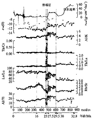
The late Oligocene to earliest Miocene deposition at ODP Site 1148 from the northern South China Sea is characterized by slumps and long sedimentation breaks. Tectonic-driven hiatuses occurred from the mid-Oligocene 28 Ma to early Miocene 23 Ma, with the main hiatus falling at 25 Ma marked by the base of the slump. The four hiatuses recognized together erased at least 3 Ma of the late Oligocene sediment record.A synthesis of lithological, biostratigraphic and geochemical resultsindicates a stepwise seafloor spreading mode for the late Oligocene South China Sea, climaxing at the"25 Ma transitional event". This series of tectonic events must have resulted from interactions between Eurasian, Australian and Philippine-Pacific plates, subsequently leading to a change in seafloor spreading toward the south where rifting had been more prominent and extension force was stronger, propably as a direct response to the sinistral strike-slip and extension by the Red River fault. The slumped deposits from Site 1148 provide the direct evidence of this spreading transition in the late Oligocene South China Sea.
The late Oligocene to earliest Miocene deposition at ODP Site 1148 from the northern South China Sea is characterized by slumps and long sedimentation breaks. Tectonic-driven hiatuses occurred from the mid-Oligocene 28 Ma to early Miocene 23 Ma, with the main hiatus falling at 25 Ma marked by the base of the slump. The four hiatuses recognized together erased at least 3 Ma of the late Oligocene sediment record.A synthesis of lithological, biostratigraphic and geochemical resultsindicates a stepwise seafloor spreading mode for the late Oligocene South China Sea, climaxing at the"25 Ma transitional event". This series of tectonic events must have resulted from interactions between Eurasian, Australian and Philippine-Pacific plates, subsequently leading to a change in seafloor spreading toward the south where rifting had been more prominent and extension force was stronger, propably as a direct response to the sinistral strike-slip and extension by the Red River fault. The slumped deposits from Site 1148 provide the direct evidence of this spreading transition in the late Oligocene South China Sea.


2005, 30(1): 25-29.
Abstract:
The Fourier transform infrared(FTIR)spectroscopy has a large advantage in paleoenvironmental study, through its measurement of various minerals in absolute proportions. This paper reports the mineral contents of Core MD01-2393, located off the Mekong River estuary in the southern South China Sea, using the FTIR method.Along with a comparison of semiquantitative determination by the X-ray diffraction(XRD)method, we present a reconstruction of the erosion and weathering history of the eastern Tibetan plateau and the Mekong basin since 190 ka in the late Quaternary. The results indicate that the bulk kaolinite/quartz ratio and clay-sized(< 2μm)kaolinite/smectites ratio may serve as mineralogical proxies of erosion and weathering occurrence in source areas. Since 190 ka in the eastern Tibetan plateau and the Mekong basin, the mechanical erosion has been stronger in glacials than in interglacials, while the chemical weathering is stronger in interglacials than in glacials, implying an Asian monsoon-controlled erosion and weathering history. During the Holocene, although both the bulk kaolinite/quartz ratio and clay-sized (< 2μm)smectites/kaolinite ratio indicate a similar evolution process of erosion and weathering, the bulk kaolinite/quartz ratio presents a stronger mechanical erosion ability. This phenomenon could be affected by rapid sea-level changes in the Mekong River estuary.
The Fourier transform infrared(FTIR)spectroscopy has a large advantage in paleoenvironmental study, through its measurement of various minerals in absolute proportions. This paper reports the mineral contents of Core MD01-2393, located off the Mekong River estuary in the southern South China Sea, using the FTIR method.Along with a comparison of semiquantitative determination by the X-ray diffraction(XRD)method, we present a reconstruction of the erosion and weathering history of the eastern Tibetan plateau and the Mekong basin since 190 ka in the late Quaternary. The results indicate that the bulk kaolinite/quartz ratio and clay-sized(< 2μm)kaolinite/smectites ratio may serve as mineralogical proxies of erosion and weathering occurrence in source areas. Since 190 ka in the eastern Tibetan plateau and the Mekong basin, the mechanical erosion has been stronger in glacials than in interglacials, while the chemical weathering is stronger in interglacials than in glacials, implying an Asian monsoon-controlled erosion and weathering history. During the Holocene, although both the bulk kaolinite/quartz ratio and clay-sized (< 2μm)smectites/kaolinite ratio indicate a similar evolution process of erosion and weathering, the bulk kaolinite/quartz ratio presents a stronger mechanical erosion ability. This phenomenon could be affected by rapid sea-level changes in the Mekong River estuary.


2005, 30(1): 31-39.
Abstract:
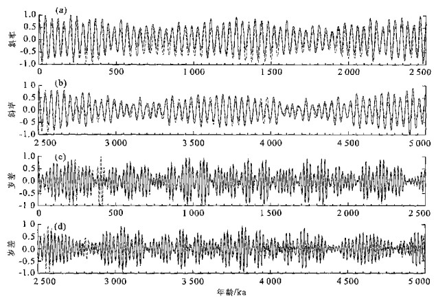
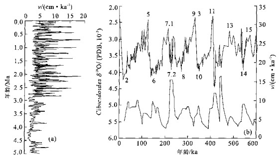
An accurate timescale derived from benthic foraminiferal δ18O is crucial to paleoceanographic studies. In global oceans, there are few continuous δ18O records for the benthic foraminifers which span the past 5 Ma and have time resolution better than 5 ka. Such representative profiles have been established for ODP Site 659 in the Atlantic and ODP Site 846 in the east Pacific, but still have been absent in the"Western Pacific Warm Pool", an area playing an important role in global climate changes. Based on the benthic foraminiferal δ18O of ODP Site 1143 in the southern South China Sea, we establish a 5 Ma astronomical timescale for the west Pacific Plio-Pleistocene, with a time resolution of ~ 2-3 ka. The phases are fixed at 8 ka and 5 ka for the obliquity and precession bands respectively, and have been applied throughout the whole records. Obliquity and precession are calculated and treated as the tuning targets.An automatic orbital tuning method has been applied in this study, which is more efficient than those used at ODP Site 659 and 846. The results show that the 190.77 m long deep sea sediments in the South China Sea have recorded a paleoceanographic history of ~ 5.02 Ma, corresponding to 191 glacial/interglacial cycles. The tuned Brunhes/Matuyama paleomagnetic polarity reversal agrees well with an age of 0.78 Ma dated previously. The tuned ages for several planktonic foraminifer bio-events also agree well with published dates, and new ages for some other bio-events in the South China Sea are also estimated. The sedimentation rates calculated from this new timescale indicate that 2.9 Ma is a threshold for the sedimentation rate in the location of Site 1143. Before this time, the average sedimentation rate is ~ 39.5 m/Ma, with a small amplitude of ~ 50 m/Ma.After this time, the average sedimentation rate jumped to ~ 65.4 m/Ma, with an amplitude as large as 200 m/Ma. In addition, the sedimentation ratesin the southern South China Sea were higher during glacials or stadials but lower during interglacials orinterstadials, especially in the late Pleistocene period. This feature might be related to the global ice volume changes, which caused different erosion, denudation and transportation during glacials and interglacials.
An accurate timescale derived from benthic foraminiferal δ18O is crucial to paleoceanographic studies. In global oceans, there are few continuous δ18O records for the benthic foraminifers which span the past 5 Ma and have time resolution better than 5 ka. Such representative profiles have been established for ODP Site 659 in the Atlantic and ODP Site 846 in the east Pacific, but still have been absent in the"Western Pacific Warm Pool", an area playing an important role in global climate changes. Based on the benthic foraminiferal δ18O of ODP Site 1143 in the southern South China Sea, we establish a 5 Ma astronomical timescale for the west Pacific Plio-Pleistocene, with a time resolution of ~ 2-3 ka. The phases are fixed at 8 ka and 5 ka for the obliquity and precession bands respectively, and have been applied throughout the whole records. Obliquity and precession are calculated and treated as the tuning targets.An automatic orbital tuning method has been applied in this study, which is more efficient than those used at ODP Site 659 and 846. The results show that the 190.77 m long deep sea sediments in the South China Sea have recorded a paleoceanographic history of ~ 5.02 Ma, corresponding to 191 glacial/interglacial cycles. The tuned Brunhes/Matuyama paleomagnetic polarity reversal agrees well with an age of 0.78 Ma dated previously. The tuned ages for several planktonic foraminifer bio-events also agree well with published dates, and new ages for some other bio-events in the South China Sea are also estimated. The sedimentation rates calculated from this new timescale indicate that 2.9 Ma is a threshold for the sedimentation rate in the location of Site 1143. Before this time, the average sedimentation rate is ~ 39.5 m/Ma, with a small amplitude of ~ 50 m/Ma.After this time, the average sedimentation rate jumped to ~ 65.4 m/Ma, with an amplitude as large as 200 m/Ma. In addition, the sedimentation ratesin the southern South China Sea were higher during glacials or stadials but lower during interglacials orinterstadials, especially in the late Pleistocene period. This feature might be related to the global ice volume changes, which caused different erosion, denudation and transportation during glacials and interglacials.


2005, 30(1): 40-46.
Abstract:
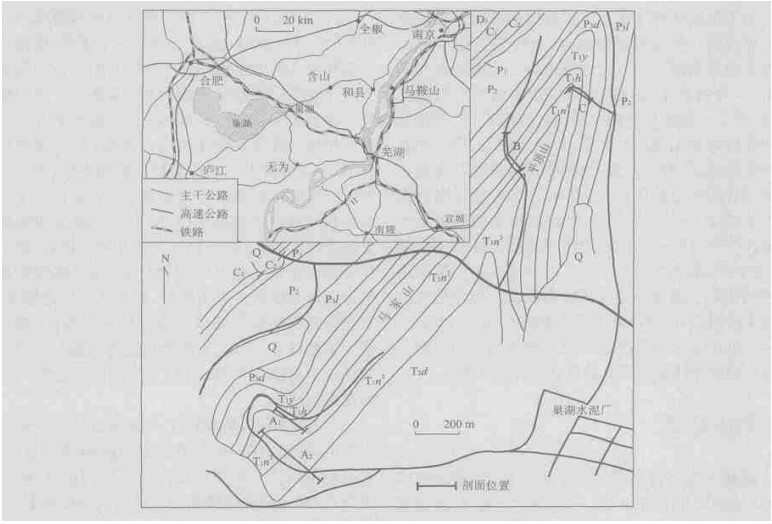
One of the GSSP(Global Stratotype Section and Point)candidates for the Induan-Olenekian boundary is situated in Chaohu, central Anhui Province, southeast China. Chaohu also has a representative and well-expressed Lower Triassic sequence that has been better studied in various aspects. This paper presents an integrated and comprehensive Lower Triassic sequence of Chaohu to serve for a standard regional stratigraphical sequence, based upon up-to-date achievements in the studies of lithostratigraphy, biostratigraphy and carbon isotope stratigraphy at three sections in the area. Eight conodont zones and six ammonoid zones are consequently well distinguished in the Lower Triassic of Chaohu, and most of them are regionally or even globally correlative. The δ13Ccarb excursion shows two characteristic shifting periods, and this carbon isotope sequence is not only of a stratigraphic value but also of great importance to understanding the biotic recovery and ecosystem reconstruction at the beginning of the Triassic. In the light of the integrated Lower Triassic sequence, a complete Lower Triassic magnetic stratigraphic sequence is established from the data at the three sections. The Lower Triassic covers five major normal polarity zones and five reversed polarity zones, and both the Permian-Triassic boundary and the Induan-Olenekian boundary are located inside normal polarity zones.
One of the GSSP(Global Stratotype Section and Point)candidates for the Induan-Olenekian boundary is situated in Chaohu, central Anhui Province, southeast China. Chaohu also has a representative and well-expressed Lower Triassic sequence that has been better studied in various aspects. This paper presents an integrated and comprehensive Lower Triassic sequence of Chaohu to serve for a standard regional stratigraphical sequence, based upon up-to-date achievements in the studies of lithostratigraphy, biostratigraphy and carbon isotope stratigraphy at three sections in the area. Eight conodont zones and six ammonoid zones are consequently well distinguished in the Lower Triassic of Chaohu, and most of them are regionally or even globally correlative. The δ13Ccarb excursion shows two characteristic shifting periods, and this carbon isotope sequence is not only of a stratigraphic value but also of great importance to understanding the biotic recovery and ecosystem reconstruction at the beginning of the Triassic. In the light of the integrated Lower Triassic sequence, a complete Lower Triassic magnetic stratigraphic sequence is established from the data at the three sections. The Lower Triassic covers five major normal polarity zones and five reversed polarity zones, and both the Permian-Triassic boundary and the Induan-Olenekian boundary are located inside normal polarity zones.


2005, 30(1): 47-51.
Abstract:
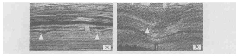
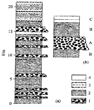
The Quaternary Huguangyan Formation in Weizhou island, Beihai City, Guangxi is mainly composed of clastic rocks with sedimentary structures developed characteristically in storm deposits, including gutter casts, hummocky or sunken cross bedding, and parallel bedding. The tempestite in the Huguangyan Formation consists of 3 types of lithofacies: A. conglomerate, sandy conglomerate and sandstone with little conglomerate with massive and graded bedding and bottom gutter casts; B. sandstone with hummocky or sunken cross bedding and parallel bedding; C. sandstone with cross-bedding. These lithofacies constitute a typical sedimentary sequence of storm deposits (A-B-C), which represent storm current (A), storm wave (B) and normal wave (C) sediment within storm event deposits. In the Late Pleistocene, Weizhou island, Beihai City was located in a lower latitude shallow marine basin. The Huguangyan Formation is mainly composed of sandstone from shallow marine background deposits, with volcanic clastics above the fair-weather wave base. The discovery of tempestite in the Huguangyan Formation reflects this region's location in a low latitude (5°-20°) zone, the tempestite formed in the shallow continental shelf controlled by storm. The discovery of the storm deposits has important significance for the interpretation of the palaeogeography and palaeoclimate of the Northern Bay in the Late Pleistocene.
The Quaternary Huguangyan Formation in Weizhou island, Beihai City, Guangxi is mainly composed of clastic rocks with sedimentary structures developed characteristically in storm deposits, including gutter casts, hummocky or sunken cross bedding, and parallel bedding. The tempestite in the Huguangyan Formation consists of 3 types of lithofacies: A. conglomerate, sandy conglomerate and sandstone with little conglomerate with massive and graded bedding and bottom gutter casts; B. sandstone with hummocky or sunken cross bedding and parallel bedding; C. sandstone with cross-bedding. These lithofacies constitute a typical sedimentary sequence of storm deposits (A-B-C), which represent storm current (A), storm wave (B) and normal wave (C) sediment within storm event deposits. In the Late Pleistocene, Weizhou island, Beihai City was located in a lower latitude shallow marine basin. The Huguangyan Formation is mainly composed of sandstone from shallow marine background deposits, with volcanic clastics above the fair-weather wave base. The discovery of tempestite in the Huguangyan Formation reflects this region's location in a low latitude (5°-20°) zone, the tempestite formed in the shallow continental shelf controlled by storm. The discovery of the storm deposits has important significance for the interpretation of the palaeogeography and palaeoclimate of the Northern Bay in the Late Pleistocene.


2005, 30(1): 52-60.
Abstract:
The peridotite section of the Dongqiao ophiolite is one of the few peridotite bodies exposed in Tibet, which may play an important role in revealing the rheological properties of the upper mantle in this area. In this paper, the microstructural and rheological characteristics of harzburgites from Dongqiao are investigated. Microstructural analysis indicates that harzburgites exhibit porphyroclastic texture and undulose extinction and kink bands are common in olivine and orthopyroxene. The oxidation decoration technique is used to examine the dislocation microstructure in olivine. The results show olivines are abundant in dislocation substructures, including free dislocation; dislocation wall, which can be subdivided further into widely and closely spaced types; and dislocation bow and net, indicating that the deformation of olivine may be dominated by dislocation creep. Following the microstructural analysis, two deformation stages are recognized. The first is deformation due to slow upper mantle flow, which results in a wide dislocation wall. The second is deformation related to the emplacement of ophiolite, which generates a closely spaced dislocation wall. The average flow stress calculated is 39.3 MPa (for the wide dislocation wall) and 113.9 MPa (for the closely spaced dislocation wall) respectively. Based on Chopra and Paterson's olivine flow law, the creep rate estimates of the upper mantle in this area are 1.13×10⁻¹²-2.95×10⁻¹¹ s-1 and effective viscosity estimates are 4.44×10¹⁷-1.16×10¹⁹ Pa°s. All these provide fundamental constraints on the rheological properties of the upper mantle in the Dongqiao area.
The peridotite section of the Dongqiao ophiolite is one of the few peridotite bodies exposed in Tibet, which may play an important role in revealing the rheological properties of the upper mantle in this area. In this paper, the microstructural and rheological characteristics of harzburgites from Dongqiao are investigated. Microstructural analysis indicates that harzburgites exhibit porphyroclastic texture and undulose extinction and kink bands are common in olivine and orthopyroxene. The oxidation decoration technique is used to examine the dislocation microstructure in olivine. The results show olivines are abundant in dislocation substructures, including free dislocation; dislocation wall, which can be subdivided further into widely and closely spaced types; and dislocation bow and net, indicating that the deformation of olivine may be dominated by dislocation creep. Following the microstructural analysis, two deformation stages are recognized. The first is deformation due to slow upper mantle flow, which results in a wide dislocation wall. The second is deformation related to the emplacement of ophiolite, which generates a closely spaced dislocation wall. The average flow stress calculated is 39.3 MPa (for the wide dislocation wall) and 113.9 MPa (for the closely spaced dislocation wall) respectively. Based on Chopra and Paterson's olivine flow law, the creep rate estimates of the upper mantle in this area are 1.13×10⁻¹²-2.95×10⁻¹¹ s-1 and effective viscosity estimates are 4.44×10¹⁷-1.16×10¹⁹ Pa°s. All these provide fundamental constraints on the rheological properties of the upper mantle in the Dongqiao area.


2005, 30(1): 61-70.
Abstract:
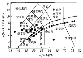
The Early Paleozoic Lajishan volcanic rock belt is located in the middle part of the Qilian orogenic belt. In order to reveal the mantle nature and tectonic affinity of the Lajishan belt, this paper presents a study of the major-trace elements and Pb-Sr-Nd isotopes of the Lajishan basalts. Based on major and trace elemental data, the Lajishan basalts can be divided into two groups: continental alkaline basalts (Group Ⅰ) and tholeiites basalts (Group Ⅱ). Group Ⅰ displays LREE enrichment, distinct Nb and Ta negative anomalies and negligible Zr and Hf anomalies. Group Ⅱ is characterized by typical OIB basalts with LREE enrichment and no Nb, Ta, Zr and Hf anomalies. The formation of Group Ⅱ is related to mantle plume. Sr-Nd-Pb isotopic compositions of basalts indicate that both Group Ⅰ and Group Ⅱ were derived from a mixing source between DM and EMⅡ mantle end-members, and have Dupal Pb isotope anomaly. A regional comparison shows that the high radiogenic Pb isotopic composition of the Lajishan basalts is similar to that of the Yangtze block mantle, and is distinctly from that of the North China mantle. This implies that the Lajishan paleo-mantle has an affinity to the Yangtze mantle instead of a part of the south margin of the North China block.
The Early Paleozoic Lajishan volcanic rock belt is located in the middle part of the Qilian orogenic belt. In order to reveal the mantle nature and tectonic affinity of the Lajishan belt, this paper presents a study of the major-trace elements and Pb-Sr-Nd isotopes of the Lajishan basalts. Based on major and trace elemental data, the Lajishan basalts can be divided into two groups: continental alkaline basalts (Group Ⅰ) and tholeiites basalts (Group Ⅱ). Group Ⅰ displays LREE enrichment, distinct Nb and Ta negative anomalies and negligible Zr and Hf anomalies. Group Ⅱ is characterized by typical OIB basalts with LREE enrichment and no Nb, Ta, Zr and Hf anomalies. The formation of Group Ⅱ is related to mantle plume. Sr-Nd-Pb isotopic compositions of basalts indicate that both Group Ⅰ and Group Ⅱ were derived from a mixing source between DM and EMⅡ mantle end-members, and have Dupal Pb isotope anomaly. A regional comparison shows that the high radiogenic Pb isotopic composition of the Lajishan basalts is similar to that of the Yangtze block mantle, and is distinctly from that of the North China mantle. This implies that the Lajishan paleo-mantle has an affinity to the Yangtze mantle instead of a part of the south margin of the North China block.


2005, 30(1): 71-77.
Abstract:
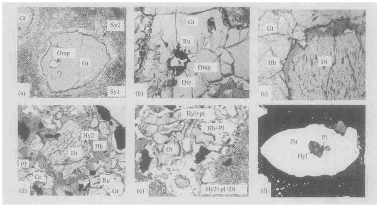
The eclogite produced from the subducted mafic lower crust of the Yangtze continental plate is a new finding within the Luotian dome in northern Dabie Mountains. The eclogites occur as lens in garnet-bearing banded gneisses. The mineral assemblage of the eclogite is garnet, omphacite, rutile and quartz; secondary minerals are hornblende, plagioclase, hypersthene, diopside and ilmenite. The eclogites from the Luotian dome have typical characteristics with relics of earlier hypersthene and plagioclase minerals of granulite-facies and latter overprinting of granulite-facies. No aqueous mineral formed during peak metamorphism may be related to their protoliths, which come from the lower crust. Petrologic evidence suggests that the eclogites studied were produced from the mafic lower crust of the Yangtze continent and suffered from granulite- and amphibolite-facies retrogressive metamorphism. At present, mafic rocks from the lower crust in the Dabie Mountains or even in the northern Yangtze plate have been scarce, which may be delaminated and recycled into underlying convecting mantle. These provide key petrologic evidence for formation and evolution of the Luotian dome, and formation and exhumation processes and uplift of high-grade metamorphic rocks such as eclogite in the northern Dabie Mountains.
The eclogite produced from the subducted mafic lower crust of the Yangtze continental plate is a new finding within the Luotian dome in northern Dabie Mountains. The eclogites occur as lens in garnet-bearing banded gneisses. The mineral assemblage of the eclogite is garnet, omphacite, rutile and quartz; secondary minerals are hornblende, plagioclase, hypersthene, diopside and ilmenite. The eclogites from the Luotian dome have typical characteristics with relics of earlier hypersthene and plagioclase minerals of granulite-facies and latter overprinting of granulite-facies. No aqueous mineral formed during peak metamorphism may be related to their protoliths, which come from the lower crust. Petrologic evidence suggests that the eclogites studied were produced from the mafic lower crust of the Yangtze continent and suffered from granulite- and amphibolite-facies retrogressive metamorphism. At present, mafic rocks from the lower crust in the Dabie Mountains or even in the northern Yangtze plate have been scarce, which may be delaminated and recycled into underlying convecting mantle. These provide key petrologic evidence for formation and evolution of the Luotian dome, and formation and exhumation processes and uplift of high-grade metamorphic rocks such as eclogite in the northern Dabie Mountains.

2005, 30(1): 78-82.
Abstract:
40Ar/39Ar dating of diagenetic illites is performed in order to determine the beginning time of gas emplacement in gas reservoirs. A series of technical problems in the 40Ar/39Ar dating of diagenetic illites have been solved in this experiment: firstly, the purification of clay minerals in order to avoid detrital contaminants; secondly, the separation of diagenetic illites from detrital illites; thirdly, Ar recoil problem, avoiding Ar loss from samples. The high refinement of clay minerals was obtained using a gentle disaggregation technique with repetitive freezing-heating cycles. Diagenetic illites were separated from detrital illites through the40Ar/39Ar age spectra of step-heating. Ar recoil problem was solved by microampoule encapsulation technique. Two kinds of age spectra were recognized during the dating of illites in the Permian reservoir sandstone in the Sulige gas field in the north of the Ordos basin, China. The first kind showed a plateau age of diagenetic illites only. The second kind showed an age of detrital illites as well as a plateau age of diagenetic illites, with a notable two-staircase age spectra. The 40Ar/39Ar dating of illites suggests that the earliest gas accumulation occurred later than 169-189 Ma. This result shows that the freezing-heating cycle technique of sample disaggregation is a key technique for obtaining the high refinement of clay minerals, which effectively avoids contamination from K-containing minerals. The technique of 40Ar/39Ar dating has been improved by a series of techniques as freezing-heating disaggregation, diagenetic illite recognition, and microampoule encapsulation, and hence can be used to determine the beginning time of gas emplacement.
40Ar/39Ar dating of diagenetic illites is performed in order to determine the beginning time of gas emplacement in gas reservoirs. A series of technical problems in the 40Ar/39Ar dating of diagenetic illites have been solved in this experiment: firstly, the purification of clay minerals in order to avoid detrital contaminants; secondly, the separation of diagenetic illites from detrital illites; thirdly, Ar recoil problem, avoiding Ar loss from samples. The high refinement of clay minerals was obtained using a gentle disaggregation technique with repetitive freezing-heating cycles. Diagenetic illites were separated from detrital illites through the40Ar/39Ar age spectra of step-heating. Ar recoil problem was solved by microampoule encapsulation technique. Two kinds of age spectra were recognized during the dating of illites in the Permian reservoir sandstone in the Sulige gas field in the north of the Ordos basin, China. The first kind showed a plateau age of diagenetic illites only. The second kind showed an age of detrital illites as well as a plateau age of diagenetic illites, with a notable two-staircase age spectra. The 40Ar/39Ar dating of illites suggests that the earliest gas accumulation occurred later than 169-189 Ma. This result shows that the freezing-heating cycle technique of sample disaggregation is a key technique for obtaining the high refinement of clay minerals, which effectively avoids contamination from K-containing minerals. The technique of 40Ar/39Ar dating has been improved by a series of techniques as freezing-heating disaggregation, diagenetic illite recognition, and microampoule encapsulation, and hence can be used to determine the beginning time of gas emplacement.


2005, 30(1): 83-88.
Abstract:
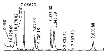
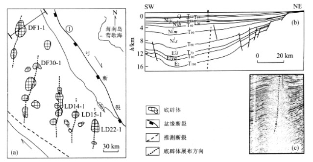
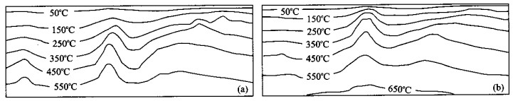
The hot fluids are intensive and frequent in the DF1-1 diapiric area, Yinggehai basin, South China Sea. Thermal fluids penetrating the strata from the deep belt generated thermal stress, which resulted in changes to the local stress field. Moving thermal fluids are capable of transporting a large amount of heat from the deep part of the basin, resulting in thermal anomalies, which heat and expand adjacent sediments to form local thermal stress. Thermal stresses controlled the stress patterns and direction of overpressure fluid migration in some locations. The structural stress associated with thermal stress induced the fluid migration system including fractures, faults and sand folds. On the other hand, because the fluids have had thermal energy and hydrocarbon or CO2 when penetrating strata from the deep, the obvious temperature differentia caused abnormal phenomena in a series of geochemical parameters, including transferring from smectite to illite, vitrinite reflectance rate, the temperature of fluid inclusions etc.. All those processes mean that the characteristics of the diapiric body and its surrounding rock are extremely different before diapirism and after diapirism. This research also demonstrates and analyzes the evolutional process of the thermal stress field and temperature field by comparing a quantitative dynamic simulation with field analysis. The results show that stress fields and temperature fields moved upwards over time. The thermal stress field also promoted the episodic opening of faults, and accelerated the hydrocarbon-bearing fluid flow upwards. The extent of the effect of thermal fluids depends on the proportion between thermal stress and tectonic stress.
The hot fluids are intensive and frequent in the DF1-1 diapiric area, Yinggehai basin, South China Sea. Thermal fluids penetrating the strata from the deep belt generated thermal stress, which resulted in changes to the local stress field. Moving thermal fluids are capable of transporting a large amount of heat from the deep part of the basin, resulting in thermal anomalies, which heat and expand adjacent sediments to form local thermal stress. Thermal stresses controlled the stress patterns and direction of overpressure fluid migration in some locations. The structural stress associated with thermal stress induced the fluid migration system including fractures, faults and sand folds. On the other hand, because the fluids have had thermal energy and hydrocarbon or CO2 when penetrating strata from the deep, the obvious temperature differentia caused abnormal phenomena in a series of geochemical parameters, including transferring from smectite to illite, vitrinite reflectance rate, the temperature of fluid inclusions etc.. All those processes mean that the characteristics of the diapiric body and its surrounding rock are extremely different before diapirism and after diapirism. This research also demonstrates and analyzes the evolutional process of the thermal stress field and temperature field by comparing a quantitative dynamic simulation with field analysis. The results show that stress fields and temperature fields moved upwards over time. The thermal stress field also promoted the episodic opening of faults, and accelerated the hydrocarbon-bearing fluid flow upwards. The extent of the effect of thermal fluids depends on the proportion between thermal stress and tectonic stress.


2005, 30(1): 89-96.
Abstract:
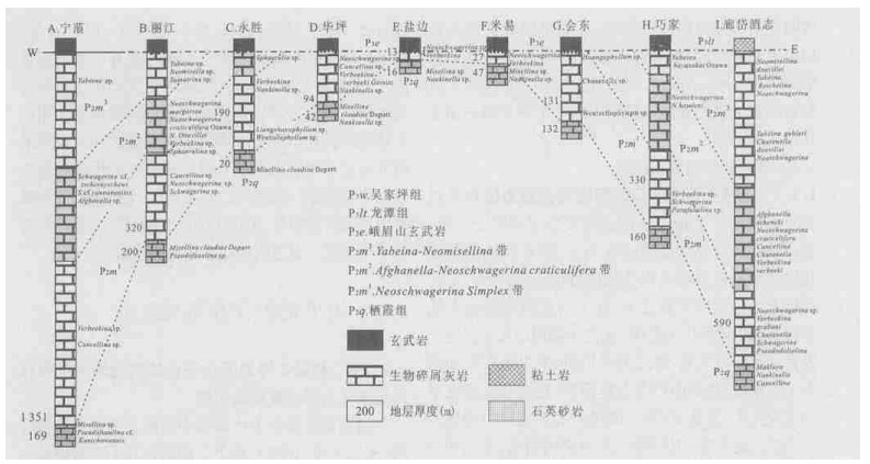
Dongwu movement is an important geological event of the Permian in South China, however, there are still lots of disputes and controversy on the timing, dimension and nature of the Dongwu movement. This paper discusses the nature, geodynamics and evolution of the Dongwu movement. It is based on biostratigraphic correlation of the Maokou Formation and the study of an unconformity and volcanism in the Upper Yangtze block, combined with an analysis of the stratigraphy, sedimentation, lithofacies and paleogeography of the Permian in South China. This research suggests that there is a genetic relationship between the rising of the Emeishan mantle-plume, the eruption of the Emeishan basalts, and the Dongwu movement. That is, the Dongwu movement is a rapid differential crustal uplift caused by the rising of the Emeishan mantle-plume. It is stronger in the west than in the east, and it began earlier in the west. This research also shows that the Dongwu movement did not extend as far as the lower Yangtze and south Huanan block, and that the sedimentation in these areas during the Permian was controlled by the Huanan block.
Dongwu movement is an important geological event of the Permian in South China, however, there are still lots of disputes and controversy on the timing, dimension and nature of the Dongwu movement. This paper discusses the nature, geodynamics and evolution of the Dongwu movement. It is based on biostratigraphic correlation of the Maokou Formation and the study of an unconformity and volcanism in the Upper Yangtze block, combined with an analysis of the stratigraphy, sedimentation, lithofacies and paleogeography of the Permian in South China. This research suggests that there is a genetic relationship between the rising of the Emeishan mantle-plume, the eruption of the Emeishan basalts, and the Dongwu movement. That is, the Dongwu movement is a rapid differential crustal uplift caused by the rising of the Emeishan mantle-plume. It is stronger in the west than in the east, and it began earlier in the west. This research also shows that the Dongwu movement did not extend as far as the lower Yangtze and south Huanan block, and that the sedimentation in these areas during the Permian was controlled by the Huanan block.


2005, 30(1): 97-101.
Abstract:
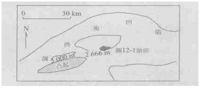
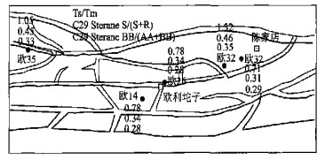
The fault sealing and reservoir continuity of different fault blocks is a very important issue for the study of oil filling histories and production. This study primarily considers the geochemical characteristics of petroleum reservoirs near faults, which can provide information about fault sealing in the geological record and hydrocarbons expulsion stage. Two research areas were chosen for the study of fault sealing in petroleum migration and reservoir continuity. One is in Weixinan sag, Beibuwan basin and the other is in Oulituozi region, Liaohe depression, Bohai Gulf basin. In the first locality, by analyzing geochemical chromatographic fingerprints, we found that a fault existed and was a major factor in poor reservoir continuity, although it is a small fault. The Oulituozi region geochemical and geological analysis shows that the oil pool near the fault has relatively high maturity and is abundant in pyrrolic nitrogen compounds. These results prove that the fault played an important role in petroleum migration. The two sites studied illustrate the advantages of geochemical techniques over other methods, in the study of fault sealing.
The fault sealing and reservoir continuity of different fault blocks is a very important issue for the study of oil filling histories and production. This study primarily considers the geochemical characteristics of petroleum reservoirs near faults, which can provide information about fault sealing in the geological record and hydrocarbons expulsion stage. Two research areas were chosen for the study of fault sealing in petroleum migration and reservoir continuity. One is in Weixinan sag, Beibuwan basin and the other is in Oulituozi region, Liaohe depression, Bohai Gulf basin. In the first locality, by analyzing geochemical chromatographic fingerprints, we found that a fault existed and was a major factor in poor reservoir continuity, although it is a small fault. The Oulituozi region geochemical and geological analysis shows that the oil pool near the fault has relatively high maturity and is abundant in pyrrolic nitrogen compounds. These results prove that the fault played an important role in petroleum migration. The two sites studied illustrate the advantages of geochemical techniques over other methods, in the study of fault sealing.


2005, 30(1): 102-108.
Abstract:
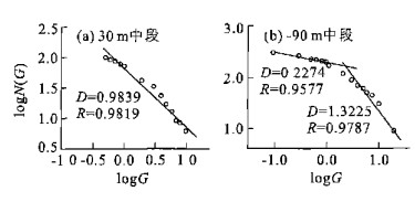
The study of metallogenic systems includes two branches: the geological background and the system's interior structure. The geological background analysis is based on the dissection of the macroscopic environments of representative metallogenic belts or typical ore deposit concentration areas. It emphasizes the contributions of both the layered structure of the earth and the coupling processes of the transformation of tectonic regimes, magmatic activity and fluid influx to the activation of regional ore-forming fluid and the initiation of large-scale mineralization. The study of interior structure aims to clarify the temporal-spatial structure of the mineralized web, the physical mechanism of ore-forming fluid transportation and the chemical process of the enrichment-migration-precipitation of metallogenic elements. It considers the relationship between these elements by analyzing the tectonics-fluids-mineralization process in multi-scales, including orefield, ore deposit and ore body scale. Taking the Northwestern Jiaodong ore deposit concentration area as an example, and using a method of interior system analysis, the authors try to reveal the influence of the exterior geological environment of the ore-forming system on the metallogenesis of the interior ore deposit concentration area, and to establish the intrinsic relations of ore-forming factors (ore-forming products, ore-forming processes etc.).Resultsshow that the transition of stress-strain field properties, created by the transformation of regional tectonic regimes, leads to regional ore-forming activity, which occurs in the temporal-spatial interfaces where the shearing stress alters from compression to tensile. The transformation also forms the complex and multivariate ore-controlled structural features. The differences of spatial structural features and mechanical properties result in the variety of regional metallogeny. Variations of stress-strain field properties in the ore deposit concentration area range cause the mutation of physicochemical parameters of ore-forming fluid, initiating the deposition of the metallogenic materials in the fluid. Over geological time, the fluid's Eh declined, and changed from an oxidation state to a deoxidation state. The fluid transport mode, which was under the control of different structural features, is the internal cause of metallogenic variety. The complexity of the ore-forming process mainly shows in the multi-fractal features of the spatial distribution of the gold ore bodies' grade and thickness, the self-similarity of alteration zoning, the inflation of ore-forming activity, and the variety of ore-forming products. This research is a new method of study in metallogeny and also an important approach to deepen the understanding of metallogenesis.
The study of metallogenic systems includes two branches: the geological background and the system's interior structure. The geological background analysis is based on the dissection of the macroscopic environments of representative metallogenic belts or typical ore deposit concentration areas. It emphasizes the contributions of both the layered structure of the earth and the coupling processes of the transformation of tectonic regimes, magmatic activity and fluid influx to the activation of regional ore-forming fluid and the initiation of large-scale mineralization. The study of interior structure aims to clarify the temporal-spatial structure of the mineralized web, the physical mechanism of ore-forming fluid transportation and the chemical process of the enrichment-migration-precipitation of metallogenic elements. It considers the relationship between these elements by analyzing the tectonics-fluids-mineralization process in multi-scales, including orefield, ore deposit and ore body scale. Taking the Northwestern Jiaodong ore deposit concentration area as an example, and using a method of interior system analysis, the authors try to reveal the influence of the exterior geological environment of the ore-forming system on the metallogenesis of the interior ore deposit concentration area, and to establish the intrinsic relations of ore-forming factors (ore-forming products, ore-forming processes etc.).Resultsshow that the transition of stress-strain field properties, created by the transformation of regional tectonic regimes, leads to regional ore-forming activity, which occurs in the temporal-spatial interfaces where the shearing stress alters from compression to tensile. The transformation also forms the complex and multivariate ore-controlled structural features. The differences of spatial structural features and mechanical properties result in the variety of regional metallogeny. Variations of stress-strain field properties in the ore deposit concentration area range cause the mutation of physicochemical parameters of ore-forming fluid, initiating the deposition of the metallogenic materials in the fluid. Over geological time, the fluid's Eh declined, and changed from an oxidation state to a deoxidation state. The fluid transport mode, which was under the control of different structural features, is the internal cause of metallogenic variety. The complexity of the ore-forming process mainly shows in the multi-fractal features of the spatial distribution of the gold ore bodies' grade and thickness, the self-similarity of alteration zoning, the inflation of ore-forming activity, and the variety of ore-forming products. This research is a new method of study in metallogeny and also an important approach to deepen the understanding of metallogenesis.


2005, 30(1): 109-113.
Abstract:
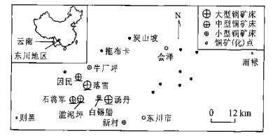
The utilization of spatial structural information is essential for mineral prediction. This paper proposes a method for the fuzzy modeling of spatial patterns of mineralization environments (SPME). SPME is the spatial distribution of geological factors and geophysical, geochemical responses (geo-variables) on/around a deposit, described by fuzzy relations of the geo-variables to spatial points. SPME related to deposits of the same genetic type in a given region are to some extent structurally similar. Based on a set of known deposits in the region, a model of SPME of the region can be built, and by maximizing the structural similarity between those known deposits, the model can be optimized. The model serves as a fuzzy deduction rule base. To evaluate the prospecting potential of any point in the region, a pattern is built on the point and the structural similarity of the pattern to the model is calculated by fuzzy deduction. A case study of copper mineral deposit prediction in the Dongchuan region of Yunnan, China, shows that the method is highly effective.
The utilization of spatial structural information is essential for mineral prediction. This paper proposes a method for the fuzzy modeling of spatial patterns of mineralization environments (SPME). SPME is the spatial distribution of geological factors and geophysical, geochemical responses (geo-variables) on/around a deposit, described by fuzzy relations of the geo-variables to spatial points. SPME related to deposits of the same genetic type in a given region are to some extent structurally similar. Based on a set of known deposits in the region, a model of SPME of the region can be built, and by maximizing the structural similarity between those known deposits, the model can be optimized. The model serves as a fuzzy deduction rule base. To evaluate the prospecting potential of any point in the region, a pattern is built on the point and the structural similarity of the pattern to the model is calculated by fuzzy deduction. A case study of copper mineral deposit prediction in the Dongchuan region of Yunnan, China, shows that the method is highly effective.


2005, 30(1): 114-120.
Abstract:
Jianghan plain lies in Chinaese east-west and south-north natural transition area. The study of climate change in this area from 30 ka plays an important part in understanding global paleoclimatic events and has been given increasing attention. In this paper, based on 14C dating, an analysis is made of magnetic susceptibility and stable organic carbon isotopes from the bored core in Zhoulao town, Jianghan plain. The results indicate that (1) magnetic susceptibility and stable organic carbon isotopes in this area have good coherence and relativity in the patterns of their evolution. Their relation to paleoclimate is that the higher values of magnetic susceptibility and the stable organic carbon isotope correspond to a colder and drier environment, while the lower values correspond to a warmer, wet environment. (2) According to the pattern of change of magnetic susceptibility and stable organic carbon isotopes, the sequence of climate change from 30 kaB.P. can be divided into 3 main stages: the age of the first stage varies from 30 000-14 100 aB.P., and the average value of magnetic susceptibility and δ13C is 655.69 ×10⁻⁶SI and -23.15×10⁻³ respectively, with a relatively high vibration curve, which is the highest of the three stages; the age of the second stage is from 14 100-3 540 aB.P., and the magnetic susceptibility and δ13C have a low vibration curve with average values of 369.38 ×10⁻⁶SI and -27.29×10⁻³; the age of the third stage is between (3 540-) 650 aB.P. and the average value of magnetic susceptibility is 311.0 ×10⁻⁶SI, the lowest of the three stages, and that of δ13C is -24.49×10⁻³, also with a high vibration curve. Each stage can be further subdivided into several climatic events. (3) The sudden change of magnetic susceptibility and organic carbon isotopes may indicate a sudden temperature change.
Jianghan plain lies in Chinaese east-west and south-north natural transition area. The study of climate change in this area from 30 ka plays an important part in understanding global paleoclimatic events and has been given increasing attention. In this paper, based on 14C dating, an analysis is made of magnetic susceptibility and stable organic carbon isotopes from the bored core in Zhoulao town, Jianghan plain. The results indicate that (1) magnetic susceptibility and stable organic carbon isotopes in this area have good coherence and relativity in the patterns of their evolution. Their relation to paleoclimate is that the higher values of magnetic susceptibility and the stable organic carbon isotope correspond to a colder and drier environment, while the lower values correspond to a warmer, wet environment. (2) According to the pattern of change of magnetic susceptibility and stable organic carbon isotopes, the sequence of climate change from 30 kaB.P. can be divided into 3 main stages: the age of the first stage varies from 30 000-14 100 aB.P., and the average value of magnetic susceptibility and δ13C is 655.69 ×10⁻⁶SI and -23.15×10⁻³ respectively, with a relatively high vibration curve, which is the highest of the three stages; the age of the second stage is from 14 100-3 540 aB.P., and the magnetic susceptibility and δ13C have a low vibration curve with average values of 369.38 ×10⁻⁶SI and -27.29×10⁻³; the age of the third stage is between (3 540-) 650 aB.P. and the average value of magnetic susceptibility is 311.0 ×10⁻⁶SI, the lowest of the three stages, and that of δ13C is -24.49×10⁻³, also with a high vibration curve. Each stage can be further subdivided into several climatic events. (3) The sudden change of magnetic susceptibility and organic carbon isotopes may indicate a sudden temperature change.


2005, 30(1): 121-128.
Abstract:
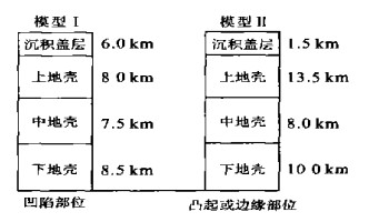
The constitution of heat flow and deeper temperature status of different layers in the Jiyang depression plays an important role in analyzing the deep structure of the lithosphere, and interpreting basin formation, evolution and dynamics. According to the latest drilling data and deep geophysical sounding results from the Jiyang depression, two typical crustal structure models which represent depression part and uplift together with margin in this area were determined respectively. This crustal structure is in four layers, composed of sediments, upper, middle and lower crust, respectively. Using the multi-channel spectrum analysis method, the U, Th and 40K content of 43 core samples in the working area were obtained. Statistical results indicate that the average heat production rate of the Jiyang depression is (1.4±0.26) μW/m3. Based on the terrestrial heat flow distribution of the basin, combined with the heat production of the Jiyang depression deep crust, the mantle heat flow was calculated by means of the "stripping" method, from the shallow to the deep layer of the crust. In addition, the temperature of the upper mantle was calculated using the one-dimensional stable state heat transfer equation.Resultsindicate that the mantle heat flow for the Jiyang depression is about 38.4-39.2 mW/m2, which amounts to 58% of the total surface heat flow. This indicates that more than half of the surface heat flow in this area is derived from the mantle. The temperature of the upper mantle is about 602-636 ℃. The Jiyang depression is characterized by a relatively high mantle heat flow value and a high ratio of mantle to surface heat flow. This thermal regime between tectonically active and stable areas is unique in comparison to any other basin in the world.
The constitution of heat flow and deeper temperature status of different layers in the Jiyang depression plays an important role in analyzing the deep structure of the lithosphere, and interpreting basin formation, evolution and dynamics. According to the latest drilling data and deep geophysical sounding results from the Jiyang depression, two typical crustal structure models which represent depression part and uplift together with margin in this area were determined respectively. This crustal structure is in four layers, composed of sediments, upper, middle and lower crust, respectively. Using the multi-channel spectrum analysis method, the U, Th and 40K content of 43 core samples in the working area were obtained. Statistical results indicate that the average heat production rate of the Jiyang depression is (1.4±0.26) μW/m3. Based on the terrestrial heat flow distribution of the basin, combined with the heat production of the Jiyang depression deep crust, the mantle heat flow was calculated by means of the "stripping" method, from the shallow to the deep layer of the crust. In addition, the temperature of the upper mantle was calculated using the one-dimensional stable state heat transfer equation.Resultsindicate that the mantle heat flow for the Jiyang depression is about 38.4-39.2 mW/m2, which amounts to 58% of the total surface heat flow. This indicates that more than half of the surface heat flow in this area is derived from the mantle. The temperature of the upper mantle is about 602-636 ℃. The Jiyang depression is characterized by a relatively high mantle heat flow value and a high ratio of mantle to surface heat flow. This thermal regime between tectonically active and stable areas is unique in comparison to any other basin in the world.