


2005 Vol. 30, No. 2
Display Method:
2005, 30(2): 129-132.
 PDF 399KB
Abstract:
Using GC/MS analysis,a series of molecular fossils,including n-alkanes,n-alkanoic acids,n-alkanols,and n-alkan-2-ones,have been identified from the Pleistocene red earth in Xuancheng,Anhui Province. The n-alkanes are proposed to be of mixed origin,derived from microorganisms and higher plants. The dominance of C29 homologue in the n-alkane distribution in most samples suggests the occurrence of trees in the region studied here. The parameter of (C27+C29)/(C31+C33) n-alkanes,representative of the abundance of grassy plants relative to woody plants,infers a varied grassy density spanning the last 1 Ma. Profiles of this ratio of n-alkanes display a varied trend comparable with the lithology,an indirect inference of paleoclimate which merits further investigation.
Using GC/MS analysis,a series of molecular fossils,including n-alkanes,n-alkanoic acids,n-alkanols,and n-alkan-2-ones,have been identified from the Pleistocene red earth in Xuancheng,Anhui Province. The n-alkanes are proposed to be of mixed origin,derived from microorganisms and higher plants. The dominance of C29 homologue in the n-alkane distribution in most samples suggests the occurrence of trees in the region studied here. The parameter of (C27+C29)/(C31+C33) n-alkanes,representative of the abundance of grassy plants relative to woody plants,infers a varied grassy density spanning the last 1 Ma. Profiles of this ratio of n-alkanes display a varied trend comparable with the lithology,an indirect inference of paleoclimate which merits further investigation.


2005, 30(2): 133-139.
Abstract:
Wendong district is a very important exploration area in Dongpu depression,and the sequence stratigraphy study is critical to find subtle trap and increase reserve and production in this district. Based on the analysis of high-resolution sequence stratigraphy in well logs (including core facies analysis,single well sequence analysis and cross wells sequence division),and interpretation of sequence stratigraphy in seismic sections,the Es3 member in Wendong district,Dongpu depression is divided into four third-order sequences: SQ1,SQ2,SQ3 and SQ4. Four main sedimentary systems can be identified in Es3. They are lacustrine-delta system,lacustrine system,gravity flow system and fan delta system. The former opinions show that shallow lake developed on the Wendong slope,gravity flow system developed in topical place and fan delta system developed in the east reigion and regressed gradually in SQ1. From SQ2 to SQ4,lacustrine system (including lacustrine beach,semideep lake,deep lake and saline lake) and the front of lacustrine delta developed on the Wendong slope; at the same time,fan-delta system developed in the east reigion and the scope became small. On the basis of the analysis of sequence stratigraphy and the depositional system,the front sand body of the lacustrine delta,and the sand bodies of the fan-delta system and gravity flow are favorable targets to explore lithologic reservoir and lith-structural reservoir in Wendong district.
Wendong district is a very important exploration area in Dongpu depression,and the sequence stratigraphy study is critical to find subtle trap and increase reserve and production in this district. Based on the analysis of high-resolution sequence stratigraphy in well logs (including core facies analysis,single well sequence analysis and cross wells sequence division),and interpretation of sequence stratigraphy in seismic sections,the Es3 member in Wendong district,Dongpu depression is divided into four third-order sequences: SQ1,SQ2,SQ3 and SQ4. Four main sedimentary systems can be identified in Es3. They are lacustrine-delta system,lacustrine system,gravity flow system and fan delta system. The former opinions show that shallow lake developed on the Wendong slope,gravity flow system developed in topical place and fan delta system developed in the east reigion and regressed gradually in SQ1. From SQ2 to SQ4,lacustrine system (including lacustrine beach,semideep lake,deep lake and saline lake) and the front of lacustrine delta developed on the Wendong slope; at the same time,fan-delta system developed in the east reigion and the scope became small. On the basis of the analysis of sequence stratigraphy and the depositional system,the front sand body of the lacustrine delta,and the sand bodies of the fan-delta system and gravity flow are favorable targets to explore lithologic reservoir and lith-structural reservoir in Wendong district.


2005, 30(2): 140-146.
Abstract:
From the forebulge to the foredeep of a foreland basin,the stratigraphic framework appears asymmetrical and wedge-shaped. The stratigraphic sequence at the forebulge is thin or absent. Research on the Kuqa foreland basin in Northern Tarim basin and previous studies on lithospheric flexural simulations of foreland basins show that accommodation space from the forebulge to the foredeep develops inconsistently due to compressional tectonism,which results in the forebulge rising while the foredeep subsides. This inconsistency is dynamically associated with the formation and migration of the forebulge. In an active tectonic phase the forebulge rises and migrates gradually toward the thrust-fault belt,which results in the basin narrowing and deepening,and the development of accommodation space becoming more and more inconsistent. In an inactive tectonic phase the basin is wide and shallow and accommodation space develops consistently. Therefore,the reflection configuration of a second-order sequence is two-layered in seismic sections such as the Jurassic and the Kapushaliang Group,Cretaceous of the Kuqa basin: the lower layer is a group of wedge-shaped,regressive reflections shrinking gradually toward the thrust-fault belt; the upper layer is a group of strap-shaped,widespread reflections. Further,the correlation model showed that the third-order sequences in the lower part of a second-order sequence onlapped gradually toward the craton,which indicates the initial tectonism and the formation of the forebulge; that the third-order sequences in the middle part gradually decrease in size toward the thrust-fault belt,corresponding to intense tectonism; that the third-order sequences in the upper part are widely distributed,corresponding to an inactive tectonic phase such as the Lower Tertiary of the Kuqa basin.
From the forebulge to the foredeep of a foreland basin,the stratigraphic framework appears asymmetrical and wedge-shaped. The stratigraphic sequence at the forebulge is thin or absent. Research on the Kuqa foreland basin in Northern Tarim basin and previous studies on lithospheric flexural simulations of foreland basins show that accommodation space from the forebulge to the foredeep develops inconsistently due to compressional tectonism,which results in the forebulge rising while the foredeep subsides. This inconsistency is dynamically associated with the formation and migration of the forebulge. In an active tectonic phase the forebulge rises and migrates gradually toward the thrust-fault belt,which results in the basin narrowing and deepening,and the development of accommodation space becoming more and more inconsistent. In an inactive tectonic phase the basin is wide and shallow and accommodation space develops consistently. Therefore,the reflection configuration of a second-order sequence is two-layered in seismic sections such as the Jurassic and the Kapushaliang Group,Cretaceous of the Kuqa basin: the lower layer is a group of wedge-shaped,regressive reflections shrinking gradually toward the thrust-fault belt; the upper layer is a group of strap-shaped,widespread reflections. Further,the correlation model showed that the third-order sequences in the lower part of a second-order sequence onlapped gradually toward the craton,which indicates the initial tectonism and the formation of the forebulge; that the third-order sequences in the middle part gradually decrease in size toward the thrust-fault belt,corresponding to intense tectonism; that the third-order sequences in the upper part are widely distributed,corresponding to an inactive tectonic phase such as the Lower Tertiary of the Kuqa basin.


2005, 30(2): 147-152.
Abstract:
The uplift of the Himalayan orogen is an interesting geological problem. In order to quantitatively discuss the uplift,its history,range and correlative problems,this paper analyzes the leucogranite by dating the apatite and zircon fission track ages. The fission track ages,which range from 17.0 to 5.7 Ma,are less than the strata ages and the intruding ages,which range from 40 to 17 Ma. So the authors infer that the violent uplift of the Himalayan orogen began in the late Cenozoic. (According) to the fission track age results of apatite,from 5.7 Ma B.P. the cooling and denudation rates were 18.421 ℃/Ma and 0.526 mm/a respectively. The relative rate of uplift and denudation during 5.7-9.2 Ma B.P.,0.229 mm/a is correspondingly faster than that during 9.2-17.0 Ma B.P.,0.032 mm/a. According to the fission track age results of zircon,the cooling rate and denudation rate from 16.2 Ma B.P.,12.963 ℃/Ma and 0.370 mm/a is less than that calculated with apatite. All the results show that the quick uplift rate and denudation rate of the Himalayan occurred from 9.2 Ma B.P..
The uplift of the Himalayan orogen is an interesting geological problem. In order to quantitatively discuss the uplift,its history,range and correlative problems,this paper analyzes the leucogranite by dating the apatite and zircon fission track ages. The fission track ages,which range from 17.0 to 5.7 Ma,are less than the strata ages and the intruding ages,which range from 40 to 17 Ma. So the authors infer that the violent uplift of the Himalayan orogen began in the late Cenozoic. (According) to the fission track age results of apatite,from 5.7 Ma B.P. the cooling and denudation rates were 18.421 ℃/Ma and 0.526 mm/a respectively. The relative rate of uplift and denudation during 5.7-9.2 Ma B.P.,0.229 mm/a is correspondingly faster than that during 9.2-17.0 Ma B.P.,0.032 mm/a. According to the fission track age results of zircon,the cooling rate and denudation rate from 16.2 Ma B.P.,12.963 ℃/Ma and 0.370 mm/a is less than that calculated with apatite. All the results show that the quick uplift rate and denudation rate of the Himalayan occurred from 9.2 Ma B.P..

2005, 30(2): 153-158.
Abstract:
Yingfeng rapakivi granite, outcropping in the north of the Qaidam basin orogenic belt between the Qaidam plate and South Qilian, is one of the Properozoic rapakivi granites found in China. This research shows that Yingfeng rapakivi granite is a typical Proterozoic rapakivi granite that has rapakivi texture and features of A-type granite, and belongs to A1 subtype, and the magma assemblage has two-apex characteristics. Rapakivi texture is mainly a polymer composed of several K-feldspar porphyritic crystals, with one plagioclase nuclear in it. The surface of the porphyritic crystal is kaolinized unevenly, its stripped structure is obvious and has orderliness. The matrix is composed of fine-particulate quartz and has obvious recrystalization and orientation textures. Its petrochemistry is characterized by high K, A/NKC < 1, A/NK > 1, belonging to quasi-aluminous rock. It is rich in minor elements Ba, U, Th, Ce, Hf, Sm, depleted in Sr, Ta, Nb, Zr, Y, Rb/Sr ((0.17)-0.6), and its Rb/Ba (0.03-0.24) ratio is very low. The differentiation of the rock is not high. The ∑REE, Ce, Zr contents are high, and the content of Ga can reach over 25×10-6, far higher than that of other granite types. Its Eu ((0.75) ×10-6-4.3×10⁻⁶) is depleted slightly, belonging to LREE enrichment type. Through the analysis of the geochemistry of minor elements and REE, Yingfeng rapakivi granite is a kind of magmatism produced in the plate. It is the "dry" magma that is formed by the granulite, which is influenced by the uprush of the mantle of base intrusion or delamination, and then melted and then differentiated, and invaded in the post-collision area at the regional extentional tectonic environment. At the same time, with the decrease of temperature, Na-plagioclase is separated from the K-feldspar and transferred to the brim of the K-feldspar to form the ring porphyritic A1 granite.
Yingfeng rapakivi granite, outcropping in the north of the Qaidam basin orogenic belt between the Qaidam plate and South Qilian, is one of the Properozoic rapakivi granites found in China. This research shows that Yingfeng rapakivi granite is a typical Proterozoic rapakivi granite that has rapakivi texture and features of A-type granite, and belongs to A1 subtype, and the magma assemblage has two-apex characteristics. Rapakivi texture is mainly a polymer composed of several K-feldspar porphyritic crystals, with one plagioclase nuclear in it. The surface of the porphyritic crystal is kaolinized unevenly, its stripped structure is obvious and has orderliness. The matrix is composed of fine-particulate quartz and has obvious recrystalization and orientation textures. Its petrochemistry is characterized by high K, A/NKC < 1, A/NK > 1, belonging to quasi-aluminous rock. It is rich in minor elements Ba, U, Th, Ce, Hf, Sm, depleted in Sr, Ta, Nb, Zr, Y, Rb/Sr ((0.17)-0.6), and its Rb/Ba (0.03-0.24) ratio is very low. The differentiation of the rock is not high. The ∑REE, Ce, Zr contents are high, and the content of Ga can reach over 25×10-6, far higher than that of other granite types. Its Eu ((0.75) ×10-6-4.3×10⁻⁶) is depleted slightly, belonging to LREE enrichment type. Through the analysis of the geochemistry of minor elements and REE, Yingfeng rapakivi granite is a kind of magmatism produced in the plate. It is the "dry" magma that is formed by the granulite, which is influenced by the uprush of the mantle of base intrusion or delamination, and then melted and then differentiated, and invaded in the post-collision area at the regional extentional tectonic environment. At the same time, with the decrease of temperature, Na-plagioclase is separated from the K-feldspar and transferred to the brim of the K-feldspar to form the ring porphyritic A1 granite.


2005, 30(2): 159-167.
Abstract:
Silurian-Devonian magmatic activity was discovered in the copulae of the Kunlun-Qinling mountains by detailed mapping and chronology analysis. Single grain zircon U-Pb dating yielded formation dates of 382-423 Ma in the intrusive rocks, which is Silurian-Devonian. The intrusive bodies are output in stocks, dikes and tectonic slices, which were suffered from later tectonism and evolved in the Kuhai-Saishitang Hercynian mélange belt as tectonic slices. The rock types are quartz-diorite, tonalite, granodiorite and monzonite granite, belonging to typical calc-alkali rocks. The characteristics of trace elements, main elements and tectonic environment discrimination reveal that the rocks were formed in an island arc tectonic environment or a continental margin arc tectonic environment. Some were also formed in a syncollisional tectonic environment, which reflects the stages of the prototethys ocean subduction and later continental crust collision. In that period intrusive rocks are in accordance with the East Kunlun Early Paleozoic magmatic activity zone, so it is suggested that a Silurian-Devonian magmatic arc developed in the copulae between the Kunlun-Qinling mountains, which joins the East Kunlun Early Paleozoic magmatic rock zone to the west. The geological characteristics and tectonic environment of the Silurian-Devonian intrusive rock in the copulae between Kunlun-Qinling Mountains indicated that the Paleotethys archipelagic ocean was formed in back-arc expandation, which was closely related to the close of the prototethys ocean.
Silurian-Devonian magmatic activity was discovered in the copulae of the Kunlun-Qinling mountains by detailed mapping and chronology analysis. Single grain zircon U-Pb dating yielded formation dates of 382-423 Ma in the intrusive rocks, which is Silurian-Devonian. The intrusive bodies are output in stocks, dikes and tectonic slices, which were suffered from later tectonism and evolved in the Kuhai-Saishitang Hercynian mélange belt as tectonic slices. The rock types are quartz-diorite, tonalite, granodiorite and monzonite granite, belonging to typical calc-alkali rocks. The characteristics of trace elements, main elements and tectonic environment discrimination reveal that the rocks were formed in an island arc tectonic environment or a continental margin arc tectonic environment. Some were also formed in a syncollisional tectonic environment, which reflects the stages of the prototethys ocean subduction and later continental crust collision. In that period intrusive rocks are in accordance with the East Kunlun Early Paleozoic magmatic activity zone, so it is suggested that a Silurian-Devonian magmatic arc developed in the copulae between the Kunlun-Qinling mountains, which joins the East Kunlun Early Paleozoic magmatic rock zone to the west. The geological characteristics and tectonic environment of the Silurian-Devonian intrusive rock in the copulae between Kunlun-Qinling Mountains indicated that the Paleotethys archipelagic ocean was formed in back-arc expandation, which was closely related to the close of the prototethys ocean.


2005, 30(2): 168-176.
Abstract:
How the movement of elements in a rock-soil system affects agriculture in a given geological environment is an entirely new study subject in petrology and geochemistry. This paper generalizes the fundamental features of the geochemical distribution of elements in various soil and rock types in the Ningguo region, Anhui Province, by means of the measurement of trace element abundance in bedrock-soil sections. The results show the regular movement patterns of elements in a rock-soil system in this region. Six trace elements Fe, Mn, Cu, Mo, Zn and B, indispensable to plant growth, are abundant in soil. It shows that, in Nanhuan system-Cambrian system, Fe, Mn and Cu are abundant in soil. This clearly suggests that the movement of elements in a rock-soil system significantly affects the growth environment of well-known agricultural, and forest products in Tianmu Mountains of Ningguo region. Walnuts, the leading product in Tianmu Mountains, are suited to the soil in the area of the Nantuo, Lantian, Yangliugang, Huayansi and Xiyangshan formations.
How the movement of elements in a rock-soil system affects agriculture in a given geological environment is an entirely new study subject in petrology and geochemistry. This paper generalizes the fundamental features of the geochemical distribution of elements in various soil and rock types in the Ningguo region, Anhui Province, by means of the measurement of trace element abundance in bedrock-soil sections. The results show the regular movement patterns of elements in a rock-soil system in this region. Six trace elements Fe, Mn, Cu, Mo, Zn and B, indispensable to plant growth, are abundant in soil. It shows that, in Nanhuan system-Cambrian system, Fe, Mn and Cu are abundant in soil. This clearly suggests that the movement of elements in a rock-soil system significantly affects the growth environment of well-known agricultural, and forest products in Tianmu Mountains of Ningguo region. Walnuts, the leading product in Tianmu Mountains, are suited to the soil in the area of the Nantuo, Lantian, Yangliugang, Huayansi and Xiyangshan formations.


2005, 30(2): 177-186.
Abstract:
Carbonate-hosted lead-zinc sulfide veins in the Upper Cambrian are located in the southern area of the Baoshan-Zhenkang Paleozoic sedimentary basin, Yunnan Province. Geologic evidence suggests that controls on the deposit are both stratigraphic and structural. The Luziyuan Pb-Zn deposit, hosted by marble and marbleization-limestone of the Shahechang Group, is the largest in this area. Mineralization consists of galena, sphalerite, chalcopyrite, pyrite, and magnetite. Alteration consists of skarnization, chloritization, silicification, pyritization, and marbleization. Fluid inclusion studies indicate that the mineralization has two main stages: the lower-middle temperature stage (homogenization temperatures of 160 ℃ to 280 ℃) and the upper-middle temperature stage (homogenization temperatures of 280 ℃ to 420 ℃). Sulfide has a very uniform S, Pb isotope composition, with δ(34S)=(9.23-10.17)×10-3, w(206Pb)/w(204Pb)=18.224-18.338, w(207Pb)/w(204Pb) =15.715-15.849, and w(208Pb)/w(204Pb)=38.381-38.874. Both the S and Pb isotopes of ore indicate the partial role of magma hydrothermal fluid in mineralization. The carbonate-hosted Pb-Zn deposits in the Zhenkang area are considered to be strata-bound hydrothermal deposits that formed in favorable tectonic areas in the basis of ore source beds, are associated with magma activities, and have the features of multi-epochs and multi-stages as well as multi-sources in mineralization.
Carbonate-hosted lead-zinc sulfide veins in the Upper Cambrian are located in the southern area of the Baoshan-Zhenkang Paleozoic sedimentary basin, Yunnan Province. Geologic evidence suggests that controls on the deposit are both stratigraphic and structural. The Luziyuan Pb-Zn deposit, hosted by marble and marbleization-limestone of the Shahechang Group, is the largest in this area. Mineralization consists of galena, sphalerite, chalcopyrite, pyrite, and magnetite. Alteration consists of skarnization, chloritization, silicification, pyritization, and marbleization. Fluid inclusion studies indicate that the mineralization has two main stages: the lower-middle temperature stage (homogenization temperatures of 160 ℃ to 280 ℃) and the upper-middle temperature stage (homogenization temperatures of 280 ℃ to 420 ℃). Sulfide has a very uniform S, Pb isotope composition, with δ(34S)=(9.23-10.17)×10-3, w(206Pb)/w(204Pb)=18.224-18.338, w(207Pb)/w(204Pb) =15.715-15.849, and w(208Pb)/w(204Pb)=38.381-38.874. Both the S and Pb isotopes of ore indicate the partial role of magma hydrothermal fluid in mineralization. The carbonate-hosted Pb-Zn deposits in the Zhenkang area are considered to be strata-bound hydrothermal deposits that formed in favorable tectonic areas in the basis of ore source beds, are associated with magma activities, and have the features of multi-epochs and multi-stages as well as multi-sources in mineralization.


2005, 30(2): 187-190.
Abstract:
Polychromatic synchrotron radiation (SR) is an effective method for the non-destructive study of diamond crystal defects. Its advantages include the use of intense X-ray, short exposure time, high collimation and high resolution. The SR method was applied to 31 diamond crystals from three major Chinese diamond mine areas: Mengyin in Shandong Province, Wafangdian in Liaoning Province and Yuanjiang area in Hunan Province. The diamond crystals generally showed structure deformation and had different degrees of deformation. Some diamonds with serious deformation demonstrated strong asterism and spot fragmentation in Laue pattern. Factors such as shape, contrast and the interior structure of reflexes in Laue patterns indicate the degree and complexity of crystal deformation.Resultsshow that the crystal imperfections have not obvious relationship to the intensity of the diamonds' brown color. It is likely that crystal defects correlate with the complex crystallization processes and deep environment of diamonds.
Polychromatic synchrotron radiation (SR) is an effective method for the non-destructive study of diamond crystal defects. Its advantages include the use of intense X-ray, short exposure time, high collimation and high resolution. The SR method was applied to 31 diamond crystals from three major Chinese diamond mine areas: Mengyin in Shandong Province, Wafangdian in Liaoning Province and Yuanjiang area in Hunan Province. The diamond crystals generally showed structure deformation and had different degrees of deformation. Some diamonds with serious deformation demonstrated strong asterism and spot fragmentation in Laue pattern. Factors such as shape, contrast and the interior structure of reflexes in Laue patterns indicate the degree and complexity of crystal deformation.Resultsshow that the crystal imperfections have not obvious relationship to the intensity of the diamonds' brown color. It is likely that crystal defects correlate with the complex crystallization processes and deep environment of diamonds.


2005, 30(2): 191-194.
Abstract:
The citrate-gel method was applied to prepare nanocrystalline CoAl2O4 spinel powders in an attempt to reduce the temperature of preparation and the calcination times. By means of thermogravimetric analysis (TG), differential scanning calorimetry (DSC) and X-ray diffraction (XRD) techniques, the phase compositions of the precursor and its calcinations at different temperatures were investigated. The spinel CoAl2O4 powders were prepared in optimum conditions: n(Co2+)/(n(Al3+)) =1∶3, citric acid to Me mole ratio of 1∶1, pH value is about 6.5, 800 ℃ heat-treatment. The citrate-gel method was shown to be a convenient method of preparing homogeneous crystalline CoAl2O4 powders with an average particle size of 60 nm and a narrow size distribution.
The citrate-gel method was applied to prepare nanocrystalline CoAl2O4 spinel powders in an attempt to reduce the temperature of preparation and the calcination times. By means of thermogravimetric analysis (TG), differential scanning calorimetry (DSC) and X-ray diffraction (XRD) techniques, the phase compositions of the precursor and its calcinations at different temperatures were investigated. The spinel CoAl2O4 powders were prepared in optimum conditions: n(Co2+)/(n(Al3+)) =1∶3, citric acid to Me mole ratio of 1∶1, pH value is about 6.5, 800 ℃ heat-treatment. The citrate-gel method was shown to be a convenient method of preparing homogeneous crystalline CoAl2O4 powders with an average particle size of 60 nm and a narrow size distribution.


2005, 30(2): 195-198.
Abstract:
To deduce the quantitative relationship between the melting point of nanoparticles and their radius, and set forth the sintering processes of nano-systems and the qualitative relation between the sintering temperature and the radius of nanoparticles from a thermodynamics angle, the phase transition process between solid and liquid states has been proposed, and thermodynamics and surface chemistry theories and phase equilibrium conditions were used. The relationship was applicable to lead (Pb). The results show that owing to its small size and high special surface free energy, the chemical potential of a material in the form of nanoparticles was much higher than that of the bulk. As a result, the melting point of nanoparticles was depressed in comparison to that of the bulk crystals. The calculated results for met al lead were coincident with the experimental ones. So there is a relationship between the melting point and the sintering temperature of a nanoparticle and its radius. The smaller the nanoparticle radius, the lower the melting point and sintering temperature.
To deduce the quantitative relationship between the melting point of nanoparticles and their radius, and set forth the sintering processes of nano-systems and the qualitative relation between the sintering temperature and the radius of nanoparticles from a thermodynamics angle, the phase transition process between solid and liquid states has been proposed, and thermodynamics and surface chemistry theories and phase equilibrium conditions were used. The relationship was applicable to lead (Pb). The results show that owing to its small size and high special surface free energy, the chemical potential of a material in the form of nanoparticles was much higher than that of the bulk. As a result, the melting point of nanoparticles was depressed in comparison to that of the bulk crystals. The calculated results for met al lead were coincident with the experimental ones. So there is a relationship between the melting point and the sintering temperature of a nanoparticle and its radius. The smaller the nanoparticle radius, the lower the melting point and sintering temperature.


2005, 30(2): 199-205.
Abstract:
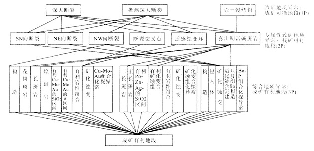
Research on earth system science has led to the production of computer-based, mathematical systematic exploration. Systematic mineral exploration is a process in which various ore-controlling factors and ore-finding signs are extensively considered, reasonably selected and arranged in order. In addition, the establishment of a mathematical model for systematic exploration meets the need of information development. The 5P met allogenic prognosis system is a better embodiment of systematic exploration. It divides mineral exploration into five different stages, with each obtaining different explored areas. 5P includes: stage 1, probable ore-forming area; stage 2, permissable ore-finding area; stage 3, preferable ore-finding area; stage 4, potential mineral resources; and stage 5, prospective ore body area. Different areas can be delineated through different mathematical models. Based on a full analysis of the previous mathematical models for mineral exploration, this paper points out that the impact of superior ore-controlling factors on subordinate ones is ignored. Thus, the links between the superior and the subordinate are cut off and this violates an integral principle of systematic exploration. In fact, superior ore-controlling factors not only influence the subordinate ones, but also exert influence on the subordinate exploration objects. A formula is presented herein for calculating the weight of the superior over the subordinate, which improves the ore-forming favorability function for delineating different ore-finding areas. A case in Himalayan granitoid rich-alkali porphyry in southern Sanjiang region, northwest Yunnan Province, provides an example for the construction of a systematic exploration model based on the 5P met allogenic prognosis system. A quantitative assessment on the Cu-Mo-Au preferable ore-finding area (the third "P") is conducted. The results show that the consistency between delineating areas and Cu-Mo-Au forming sections is relatively high, indicating the feasibility of the method suggested.
Research on earth system science has led to the production of computer-based, mathematical systematic exploration. Systematic mineral exploration is a process in which various ore-controlling factors and ore-finding signs are extensively considered, reasonably selected and arranged in order. In addition, the establishment of a mathematical model for systematic exploration meets the need of information development. The 5P met allogenic prognosis system is a better embodiment of systematic exploration. It divides mineral exploration into five different stages, with each obtaining different explored areas. 5P includes: stage 1, probable ore-forming area; stage 2, permissable ore-finding area; stage 3, preferable ore-finding area; stage 4, potential mineral resources; and stage 5, prospective ore body area. Different areas can be delineated through different mathematical models. Based on a full analysis of the previous mathematical models for mineral exploration, this paper points out that the impact of superior ore-controlling factors on subordinate ones is ignored. Thus, the links between the superior and the subordinate are cut off and this violates an integral principle of systematic exploration. In fact, superior ore-controlling factors not only influence the subordinate ones, but also exert influence on the subordinate exploration objects. A formula is presented herein for calculating the weight of the superior over the subordinate, which improves the ore-forming favorability function for delineating different ore-finding areas. A case in Himalayan granitoid rich-alkali porphyry in southern Sanjiang region, northwest Yunnan Province, provides an example for the construction of a systematic exploration model based on the 5P met allogenic prognosis system. A quantitative assessment on the Cu-Mo-Au preferable ore-finding area (the third "P") is conducted. The results show that the consistency between delineating areas and Cu-Mo-Au forming sections is relatively high, indicating the feasibility of the method suggested.

2005, 30(2): 206-210.
Abstract:
Xiangshan uranium orefield is one of the largest volcanic rock type hydrothermal uranium orefield in China. Beginning with modern warm hot-water in the orefield, and applying hydrogeochemistry and isotopic hydrogeology, this paper (analyzes) the geothermal characteristics of typical deposits, studies supply and heat sources of warm hot-water, and discusses the relation between hot-water and uranium mineralization according to the mechanism of uranium metallogenesis. The warm hot-water in Xiangshan orefield is hot-water of uplift fault type, meteoric water is the major supply source of warm hot- (water); deep circulation of groundwater and radioactive heat are the main channels for warm hot-water to obtain heat energy; hot-water activity made an important contribution to uranium metallogenesis; the uranium source mainly comes from water-rock interaction; a space unit is formed on integration with geothermal high field, warm hot-water and uranium mineralization which are controlled by base tectonics and volcano cover structure.
Xiangshan uranium orefield is one of the largest volcanic rock type hydrothermal uranium orefield in China. Beginning with modern warm hot-water in the orefield, and applying hydrogeochemistry and isotopic hydrogeology, this paper (analyzes) the geothermal characteristics of typical deposits, studies supply and heat sources of warm hot-water, and discusses the relation between hot-water and uranium mineralization according to the mechanism of uranium metallogenesis. The warm hot-water in Xiangshan orefield is hot-water of uplift fault type, meteoric water is the major supply source of warm hot- (water); deep circulation of groundwater and radioactive heat are the main channels for warm hot-water to obtain heat energy; hot-water activity made an important contribution to uranium metallogenesis; the uranium source mainly comes from water-rock interaction; a space unit is formed on integration with geothermal high field, warm hot-water and uranium mineralization which are controlled by base tectonics and volcano cover structure.


2005, 30(2): 211-214+254.
Abstract:
Source rock potential and trap efficiency determine the success of petroleum exploration in the Dunhuang basin, Gansu Province, China. According to the integrated analysis of surface section and sedimentary sequences, the authors analyze the geological elements (source rocks, reservoir, sealing and overlaid rocks) and processes (migration, accumulation and trapping) of the Middle and Lower Jurassic petroleum system in the Dunhuang basin. The results indicate that the Middle and Lower Jurassic dark mudstones and carbonous shales in coal-bearing measures have been inferred to be the main source rocks in the southwestern basin, there is a possibility of using petroleum system theory in the exploration of the Dunhuang basin, Gansu Province in China, and the sandstones lying above the unconformities may be taken as the main targets for hydrocarbon exploration.
Source rock potential and trap efficiency determine the success of petroleum exploration in the Dunhuang basin, Gansu Province, China. According to the integrated analysis of surface section and sedimentary sequences, the authors analyze the geological elements (source rocks, reservoir, sealing and overlaid rocks) and processes (migration, accumulation and trapping) of the Middle and Lower Jurassic petroleum system in the Dunhuang basin. The results indicate that the Middle and Lower Jurassic dark mudstones and carbonous shales in coal-bearing measures have been inferred to be the main source rocks in the southwestern basin, there is a possibility of using petroleum system theory in the exploration of the Dunhuang basin, Gansu Province in China, and the sandstones lying above the unconformities may be taken as the main targets for hydrocarbon exploration.


2005, 30(2): 215-220.
Abstract:
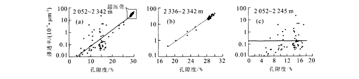
Research into hydrocarbon basins around the world has shown that overpressure is closely connected with hydrocarbon generation and distribution. Because of unique sedimentary sequences and temperature-pressure characteristics, reservoir diagenesis has larruping processes and traits. Through comparing two types of overpressure systems (self-source type and conduction type), confirmed by core and log, this paper illustrates their origin and hydrocarbon value, and sets forth the effects of high temperature and overpressure on reservoir qualities, which include: ① reservoir characteristics are mainly determined by sedimentary environment and diagenesis; ② high geotemperature gradient decreases sandstone porosity; ③ (overpressure) conserves parts of original porosity, which causes high porosity in a deep reservoir; ④ overpressure brings out much of secondary porosity in the processes of diagenesis; ⑤ fluid breakthrough causes cracks, which effectively increase reservoir permeability.
Research into hydrocarbon basins around the world has shown that overpressure is closely connected with hydrocarbon generation and distribution. Because of unique sedimentary sequences and temperature-pressure characteristics, reservoir diagenesis has larruping processes and traits. Through comparing two types of overpressure systems (self-source type and conduction type), confirmed by core and log, this paper illustrates their origin and hydrocarbon value, and sets forth the effects of high temperature and overpressure on reservoir qualities, which include: ① reservoir characteristics are mainly determined by sedimentary environment and diagenesis; ② high geotemperature gradient decreases sandstone porosity; ③ (overpressure) conserves parts of original porosity, which causes high porosity in a deep reservoir; ④ overpressure brings out much of secondary porosity in the processes of diagenesis; ⑤ fluid breakthrough causes cracks, which effectively increase reservoir permeability.


2005, 30(2): 221-227.
Abstract:
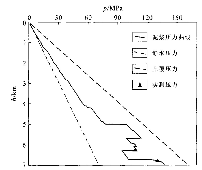
The origin and distribution of formation overpressure has an effect not only on hydrocarbon migration and accumulation, but also on drilling well technique. The study and prediction of overpressure is very important in basin study. (Yangxia) sag is a sub-tectonic unit in Kuqa depression. Drilling shows overpressure is very common in Yangxia sag. Using logs, test materials and seismic data, this paper analyzes the origin of overpressure and its influence on oil and gas pool-forming.Resultsshow that: (1) Overpressure in Jidike Formation is mainly developed by deposition, and overpressure in Cretaceous by tectonic stress. These two overpressure systems are completely different in origin. (2) The overpressure in the Baxigai and Bashijiqike formations formed in the Pliocene when the Kuqa Formation was deposited, that is earlier than the Kuqa-Xiyu period when oil and gas migrated on a large scale. The overpressure cannot be released by the faults because there are faults around the Ku1 well area, which resisted oil and gas entering the reservoir and influenced pool-forming.
The origin and distribution of formation overpressure has an effect not only on hydrocarbon migration and accumulation, but also on drilling well technique. The study and prediction of overpressure is very important in basin study. (Yangxia) sag is a sub-tectonic unit in Kuqa depression. Drilling shows overpressure is very common in Yangxia sag. Using logs, test materials and seismic data, this paper analyzes the origin of overpressure and its influence on oil and gas pool-forming.Resultsshow that: (1) Overpressure in Jidike Formation is mainly developed by deposition, and overpressure in Cretaceous by tectonic stress. These two overpressure systems are completely different in origin. (2) The overpressure in the Baxigai and Bashijiqike formations formed in the Pliocene when the Kuqa Formation was deposited, that is earlier than the Kuqa-Xiyu period when oil and gas migrated on a large scale. The overpressure cannot be released by the faults because there are faults around the Ku1 well area, which resisted oil and gas entering the reservoir and influenced pool-forming.


2005, 30(2): 228-232.
Abstract:
Organic inclusion is of great importance to the study of development, migration and origin of oil and gas. In Southwest Sichuan basin there are many pores, holes and fractures in the Sinian Dengying reservoir. The pore spaces were filled by dolomites and quarters of different stages. This paper analyzes the characteristics, fluorescence, homogenization temperatures, and chemical and isotopic compositions of the organic inclusions in the filled minerals of different stages. The homogenization temperatures of the organic inclusions in different stages distribute between 120-150 ℃, 160-190 ℃ and 200-(210 ℃). The chief chemical composition of the organic inclusions is CH4 and CO2. CH4 contents of different stages' inclusions are respectively 10.09%-22.08%, 27.06%-40.40%, 55.33%-74.01%, corresponding values of their CO2/CH4 content being 3.37-5.87, 1.20-2.20, 0.26-0.63. On this basis, the authors analyze the stages of the origin, development, migration and accumulation of oil and gas. Results show that the natural gas is oil-generating. CO2 is of organic origin and there is a little inorganic CO2. There are three stages of migration and accumulation of oil and gas in the Sinian Dengying reservoir, which are different in history of development.
Organic inclusion is of great importance to the study of development, migration and origin of oil and gas. In Southwest Sichuan basin there are many pores, holes and fractures in the Sinian Dengying reservoir. The pore spaces were filled by dolomites and quarters of different stages. This paper analyzes the characteristics, fluorescence, homogenization temperatures, and chemical and isotopic compositions of the organic inclusions in the filled minerals of different stages. The homogenization temperatures of the organic inclusions in different stages distribute between 120-150 ℃, 160-190 ℃ and 200-(210 ℃). The chief chemical composition of the organic inclusions is CH4 and CO2. CH4 contents of different stages' inclusions are respectively 10.09%-22.08%, 27.06%-40.40%, 55.33%-74.01%, corresponding values of their CO2/CH4 content being 3.37-5.87, 1.20-2.20, 0.26-0.63. On this basis, the authors analyze the stages of the origin, development, migration and accumulation of oil and gas. Results show that the natural gas is oil-generating. CO2 is of organic origin and there is a little inorganic CO2. There are three stages of migration and accumulation of oil and gas in the Sinian Dengying reservoir, which are different in history of development.


2005, 30(2): 233-240.
Abstract:
The technique of stabilizing piles with pre-stressed anchored cables is an effective measure in landslide remediation works, which nowadays has a wide application in many fields. However, the design and calculating methods of this technique need more attention and urgent research work. Stabilizing piles with pre-stressed anchored cables are a development of the technique of using stabilizing piles. Compared to the use of stabilizing piles alone, anchored cables make the state of the forces on piles more reasonable. A mechanical and mathematical model of piles with pre-stressed anchored cables has been set up, based on a geological and physical model of this landslide stabilizing system. This model establishes the foundation of the calculations for the structural design of the system. The analytical and numerical solutions of the established mathematical model have been achieved. The "two-parameter method" is employed to calculate the coefficient of subgrade reactions or subgrade modulus. The two models, of rigid and elastic piles respectively, are discussed, in which the anchored cable is regarded as an elastic hinge. Under the consideration of deformation harmony between anchored cables and the pile body, the tensile force of anchored cables has been obtained, as well as a solution for internal force distribution along the pile body. A case study in the reservoir areas of the Three Gorges Project is presented in the last part of the paper, in which the application of this technique in landslide remediation works is analyzed and discussed in detail.
The technique of stabilizing piles with pre-stressed anchored cables is an effective measure in landslide remediation works, which nowadays has a wide application in many fields. However, the design and calculating methods of this technique need more attention and urgent research work. Stabilizing piles with pre-stressed anchored cables are a development of the technique of using stabilizing piles. Compared to the use of stabilizing piles alone, anchored cables make the state of the forces on piles more reasonable. A mechanical and mathematical model of piles with pre-stressed anchored cables has been set up, based on a geological and physical model of this landslide stabilizing system. This model establishes the foundation of the calculations for the structural design of the system. The analytical and numerical solutions of the established mathematical model have been achieved. The "two-parameter method" is employed to calculate the coefficient of subgrade reactions or subgrade modulus. The two models, of rigid and elastic piles respectively, are discussed, in which the anchored cable is regarded as an elastic hinge. Under the consideration of deformation harmony between anchored cables and the pile body, the tensile force of anchored cables has been obtained, as well as a solution for internal force distribution along the pile body. A case study in the reservoir areas of the Three Gorges Project is presented in the last part of the paper, in which the application of this technique in landslide remediation works is analyzed and discussed in detail.


2005, 30(2): 241-244.
Abstract:
Landslide surveys and preventative analysis have shown that underground water is a sensitivity factor of landslide stability analysis. Therefore, it is important to obtain the underground water level at the site of a landslide. There are different types of underground water levels which this paper refers to as the de-layer underground water level in landslides, due to multiple substance composition and diverse permeability. The water level of a terminal borehole is synthesis level for borehole, and cannot distinguish multi-underground water levels by itself. The de-layer technique of underground water observation could solve the above problems. This paper introduces the systematic de-layer technique of underground water observation and analyzes the results and significance for landslide prevention using the examples of the Heping square landslide and the Huanglashi landslide in the reservoir region of the Three Gorges Project.
Landslide surveys and preventative analysis have shown that underground water is a sensitivity factor of landslide stability analysis. Therefore, it is important to obtain the underground water level at the site of a landslide. There are different types of underground water levels which this paper refers to as the de-layer underground water level in landslides, due to multiple substance composition and diverse permeability. The water level of a terminal borehole is synthesis level for borehole, and cannot distinguish multi-underground water levels by itself. The de-layer technique of underground water observation could solve the above problems. This paper introduces the systematic de-layer technique of underground water observation and analyzes the results and significance for landslide prevention using the examples of the Heping square landslide and the Huanglashi landslide in the reservoir region of the Three Gorges Project.


2005, 30(2): 245-249.
Abstract:
Hydrochemical zonality was delineated for deep-lying pore water in Taiyuan. SO4-HCO3 water, HCO3-SO4 water and HCO3 water occur sequentially from mountain area to basin area, in north to south zonal distribution, which is highly correlative with the hydrochemistry of supply water. To understand the forming process of deep-lying pore water hydrochemistry at Taiyuan, a series of groundwater mixing models were set up using PHREEQC. The results indicate that the deep pore water of the northern basin is recharged by karst water from the northern mountain area, shallow pore water from the northern basin, and Fenhe River water. Karst water from the northern mountain area is the most important source of recharge. Deep pore water in the western basin is recharged by karst water from the western mountain area and shallow pore water from the western basin. Hydrochemistry of deep pore water in the southern basin is affected by the mixing of deep pore water from the western basin with that from the northern basin. According to above analysis, the mixing process is the most important in forming the hydrochemistry of deep pore water at Taiyuan.
Hydrochemical zonality was delineated for deep-lying pore water in Taiyuan. SO4-HCO3 water, HCO3-SO4 water and HCO3 water occur sequentially from mountain area to basin area, in north to south zonal distribution, which is highly correlative with the hydrochemistry of supply water. To understand the forming process of deep-lying pore water hydrochemistry at Taiyuan, a series of groundwater mixing models were set up using PHREEQC. The results indicate that the deep pore water of the northern basin is recharged by karst water from the northern mountain area, shallow pore water from the northern basin, and Fenhe River water. Karst water from the northern mountain area is the most important source of recharge. Deep pore water in the western basin is recharged by karst water from the western mountain area and shallow pore water from the western basin. Hydrochemistry of deep pore water in the southern basin is affected by the mixing of deep pore water from the western basin with that from the northern basin. According to above analysis, the mixing process is the most important in forming the hydrochemistry of deep pore water at Taiyuan.


2005, 30(2): 250-254.
Abstract:
One of the main factors attributed to landslide causation is rainfall. On the basis of historic landslide information from Chun'an, Pan'an, Qingyuan and Yongjia, in east China's Zhejiang Province, this paper studies the relationship between rainfall, rain intensity, rain process, and the spatial distribution and time effects of landslides. Statistical connections between time, spatial distribution and precipitation are set up, and the critical rainfall and the threshold values of rain intensity are presented. Based on these, a warning system for rain-induced landslides is developed. In the system, the critical rainfall model and effective rainfall model were adopted for prediction, and an interface was provided for the Zhejiang Province observatory. The rain data will be uploaded to the server using this interface, and saved in a Microsoft SQL Server database. The data can be obtained automatically from the database to build a real-time curve between time and rainfall. When the rain intensity reaches the rainfall threshold values, a geo-hazards map will be triggered, prediction information will be released, and preventative measures will be provided via the Internet.
One of the main factors attributed to landslide causation is rainfall. On the basis of historic landslide information from Chun'an, Pan'an, Qingyuan and Yongjia, in east China's Zhejiang Province, this paper studies the relationship between rainfall, rain intensity, rain process, and the spatial distribution and time effects of landslides. Statistical connections between time, spatial distribution and precipitation are set up, and the critical rainfall and the threshold values of rain intensity are presented. Based on these, a warning system for rain-induced landslides is developed. In the system, the critical rainfall model and effective rainfall model were adopted for prediction, and an interface was provided for the Zhejiang Province observatory. The rain data will be uploaded to the server using this interface, and saved in a Microsoft SQL Server database. The data can be obtained automatically from the database to build a real-time curve between time and rainfall. When the rain intensity reaches the rainfall threshold values, a geo-hazards map will be triggered, prediction information will be released, and preventative measures will be provided via the Internet.


2005, 30(2): 255-258.
Abstract:
A municipal network system is an important part of a city's geographic information system. Based on the GIS platform—ArcGIS and applying the technology of middleware—Catalog and Geodatabase, the authors design the Shiyan City gas-pipe database. At the same time, the authors integrate the RGBMS outside the GIS and the gas-pipe DMS on a platform that is based on the visual management of GIS spatial data, and successfully realize the unified management of geometric relational data, logic relational data and dynamically-inspected data. The geometric topology relation of the municipal pipe-network spatial data was established using the feature class and the feature dataset of the pipe-line, and the logic topology rule was established using Catalog and the Geodatabase. It can represent exactly all kinds of linked relations held by the industrial pipe's physical network and dynamic flow system. Supported by the data interface of real-time inspection and by the system of SKADA and RTU, the physical feature data of the hydro-data of the pipeline can be obtained. It provides the dynamic and inspected spatial information for the DMS that is offered for gas control and accident forecast. Based on the frame of C/S and B/S, the system is integrated and holds practical application values.
A municipal network system is an important part of a city's geographic information system. Based on the GIS platform—ArcGIS and applying the technology of middleware—Catalog and Geodatabase, the authors design the Shiyan City gas-pipe database. At the same time, the authors integrate the RGBMS outside the GIS and the gas-pipe DMS on a platform that is based on the visual management of GIS spatial data, and successfully realize the unified management of geometric relational data, logic relational data and dynamically-inspected data. The geometric topology relation of the municipal pipe-network spatial data was established using the feature class and the feature dataset of the pipe-line, and the logic topology rule was established using Catalog and the Geodatabase. It can represent exactly all kinds of linked relations held by the industrial pipe's physical network and dynamic flow system. Supported by the data interface of real-time inspection and by the system of SKADA and RTU, the physical feature data of the hydro-data of the pipeline can be obtained. It provides the dynamic and inspected spatial information for the DMS that is offered for gas control and accident forecast. Based on the frame of C/S and B/S, the system is integrated and holds practical application values.
