2005 Vol. 30, No. 3
Display Method:
2005, 30(3): 259-263.
 PDF 547KB
Abstract:
The Dengfeng Group and Angou Group from the Dengfeng area, Henan Province preserve rocks at the Archean- Proterozoic boundary.Kröner et al.(1988) yielded an SHRIMP U-Pb zircon age of (2 512± 12) Ma for a date from the up- per Dengfeng Group. Here we report an Sm-Nd whole rock isochron age of (2 507± 96) Ma (MSWD= 6.3) for 7 volcanic rocks from the Angou Group with initial 143Nd/144Nd= 0.509 560± 0.000 093, which corresponds to εNd(2.5 Ga)= 3.27± 1.82. This constrains an age difference of less than 113 Ma between the top of Dengfeng and the bottom of Angou volcanic rocks. The less evolved Angou metatholeiites are characterized by asthenospheric La/Nb ratios (< 2.0). Together with the bimodal character, it is inferred that the Angou Group formed in a continental rift setting.
The Dengfeng Group and Angou Group from the Dengfeng area, Henan Province preserve rocks at the Archean- Proterozoic boundary.


2005, 30(3): 264-274.
Abstract:
Dabie mountains are a collision orogen between the Yangtze and the North China blocks. The rock components, isotopic dating and tectonic relation of the tectonic-petrological units in the eastern Dabie orogen indicate that the Dabie orogen is composed mainly of the metamorphic basement suffered different-grade metamorphism and low-grade metamorphic cover of the north margin of the Yangtze block, without ophiolitic mélange and Paleozoic vocanic-intrusive rock association in the south margin of the North China block. The boundary between the tectonic-petrological units is extensional shear zone developed in the exhumation process of the ultra-high pressure metamorphic rocks, and the extensional-thrust and nappe structure in the northern part of the Dabie Mountains is also one part of the extensional structures in the exhumation process of the ultra-high pressure metamorphic rocks. There is no key tectonic boundary indicating the occurrence of the suture zone. Therefore, not the Shuihou-Wuhe shear zone, nor the Mozitan-Xiaotian fault are the suture zone between the Yangtze and the North China blocks. Combining the geophysical data, the Xinyang-Shucheng fault is the Indo-Chinese suture between the Yangtze and the North China blocks, but now is covered under the Mesozoic and Cenozoic deposits of the Hefei basin.
Dabie mountains are a collision orogen between the Yangtze and the North China blocks. The rock components, isotopic dating and tectonic relation of the tectonic-petrological units in the eastern Dabie orogen indicate that the Dabie orogen is composed mainly of the metamorphic basement suffered different-grade metamorphism and low-grade metamorphic cover of the north margin of the Yangtze block, without ophiolitic mélange and Paleozoic vocanic-intrusive rock association in the south margin of the North China block. The boundary between the tectonic-petrological units is extensional shear zone developed in the exhumation process of the ultra-high pressure metamorphic rocks, and the extensional-thrust and nappe structure in the northern part of the Dabie Mountains is also one part of the extensional structures in the exhumation process of the ultra-high pressure metamorphic rocks. There is no key tectonic boundary indicating the occurrence of the suture zone. Therefore, not the Shuihou-Wuhe shear zone, nor the Mozitan-Xiaotian fault are the suture zone between the Yangtze and the North China blocks. Combining the geophysical data, the Xinyang-Shucheng fault is the Indo-Chinese suture between the Yangtze and the North China blocks, but now is covered under the Mesozoic and Cenozoic deposits of the Hefei basin.


2005, 30(3): 275-288.
Abstract:
The North Himalayan antiform is exposed a series of gneiss domes, intruded by the North Himalayan leucogranites(NHL)with magma emplacement ages from 27.5 to 10 Ma. The NHL are dominated by two-mica granites. They have SiO2=70.97%-74.54%, K2O+ Na2O=6.27%-8.09%, K2O/Na2O=0.91-1.36 and A/CNK=1.10-1.33. However, they display wide variations of trace element composition with Rb=(41-322)×10-6, Sr=(26-139)×10-6, Ba= (135-594)×10-6, (La/Yb)N=0.97-17.31, Eu/Eu* =0.29-0.72. Each body reveals distinct inter-granite trace element characteristics suggesting that each body results from distinctive conditions. The granites from the NHL resemble the two-mica granites from the High Himalayan leucogranites(HHL), but are distinct from tourmaline-muscovite granites from the HHL in their Ti, Mg, Ca, Ba contents and Rb/Sr ratio. The NHL have(87Sr/86Sr)t=0.734 4-0.850 3(for t=10 Ma) and εNd(10 Ma)=-12.5 to-19.3, which are indistinguishable from the HHL. Both the NHL and the HHL were derived from the anatexis of the High Himalayan Crystalline Series(HHCS)under the condition of fluid-absent melting, induced by muscovite breakdown due to decompression. The magma emplacement ages and the geological setting of the NHL are quite distinct from those of the HHL. Whilst the HHL resulted from southwards extrusion of the tectonic wedge of the HHCS during the Miocene, the NHL appear to have been generated over a much longer timespan, involving early melting during crustal thickening and subsequent melting during the exhumation of the gneiss domes. Thus the NHL and the HHL have different tectonic implications.
The North Himalayan antiform is exposed a series of gneiss domes, intruded by the North Himalayan leucogranites(NHL)with magma emplacement ages from 27.5 to 10 Ma. The NHL are dominated by two-mica granites. They have SiO2=70.97%-74.54%, K2O+ Na2O=6.27%-8.09%, K2O/Na2O=0.91-1.36 and A/CNK=1.10-1.33. However, they display wide variations of trace element composition with Rb=(41-322)×10-6, Sr=(26-139)×10-6, Ba= (135-594)×10-6, (La/Yb)N=0.97-17.31, Eu/Eu* =0.29-0.72. Each body reveals distinct inter-granite trace element characteristics suggesting that each body results from distinctive conditions. The granites from the NHL resemble the two-mica granites from the High Himalayan leucogranites(HHL), but are distinct from tourmaline-muscovite granites from the HHL in their Ti, Mg, Ca, Ba contents and Rb/Sr ratio. The NHL have(87Sr/86Sr)t=0.734 4-0.850 3(for t=10 Ma) and εNd(10 Ma)=-12.5 to-19.3, which are indistinguishable from the HHL. Both the NHL and the HHL were derived from the anatexis of the High Himalayan Crystalline Series(HHCS)under the condition of fluid-absent melting, induced by muscovite breakdown due to decompression. The magma emplacement ages and the geological setting of the NHL are quite distinct from those of the HHL. Whilst the HHL resulted from southwards extrusion of the tectonic wedge of the HHCS during the Miocene, the NHL appear to have been generated over a much longer timespan, involving early melting during crustal thickening and subsequent melting during the exhumation of the gneiss domes. Thus the NHL and the HHL have different tectonic implications.


2005, 30(3): 289-297.
Abstract:
Middle Devonian picrites of the south margin of Altay orogenic belt occur in the lower part of the Beitashan Fm., overlain by basalts and andesite. They are characterized by a depletion of Ti and enrichment of Fe, negative anomalies of Nb and Ta with abundance of HFSE as MORB, exhibiting typical island arc magmas. They may result from the southwestward subduction of the Junggar ocean plate. The Zr/Nb ratios of the picrites and basalts resemble the MORB, suggesting MORB-like sources. However, Ti/V and Zr/Sm ratios are higher than those of picrites, and the basalts display flat-type REE-chondrite patterns whereas the picrites are characterized by lower total REE concentrations and a slight enrichment of light REE. All suggest that the basalts were generated by lower partial melting of amphibole-bearing spinel peridotite, which was metasomatized by fluids released from the subducted oceanic crust, and the picrites resulted from the higher degree of partial melting of metasomatized garnet peridotite under high temperatures. The andesite may have resulted from the partial melting of eclogites.
Middle Devonian picrites of the south margin of Altay orogenic belt occur in the lower part of the Beitashan Fm., overlain by basalts and andesite. They are characterized by a depletion of Ti and enrichment of Fe, negative anomalies of Nb and Ta with abundance of HFSE as MORB, exhibiting typical island arc magmas. They may result from the southwestward subduction of the Junggar ocean plate. The Zr/Nb ratios of the picrites and basalts resemble the MORB, suggesting MORB-like sources. However, Ti/V and Zr/Sm ratios are higher than those of picrites, and the basalts display flat-type REE-chondrite patterns whereas the picrites are characterized by lower total REE concentrations and a slight enrichment of light REE. All suggest that the basalts were generated by lower partial melting of amphibole-bearing spinel peridotite, which was metasomatized by fluids released from the subducted oceanic crust, and the picrites resulted from the higher degree of partial melting of metasomatized garnet peridotite under high temperatures. The andesite may have resulted from the partial melting of eclogites.


2005, 30(3): 298-308.
Abstract:
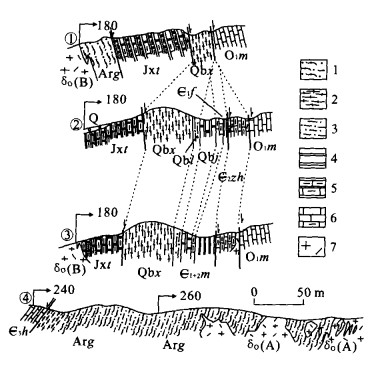
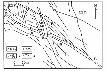
A study of structures, deformation and strain of country rocks around Fangshan pluton in the western Hills, Beijing, reveals a high-temperature shear aureole, domal distribution of steep lineations and foliations in the thermodynamic aureole, and ring synclines around the pluton. Combining with the analysis of the regional tectonic events, it is concluded that Fangshan pluton is a real magmatic diapir (hot-stokes diapir). To our knowledge, this is the first reported magmatic diapir in the world. As such, this research result argues for a reconsideration of the structural frame and deformational series of the Zhoukoudian area. It is suggested that the Fangshan metamorphic core complex did not exist; the Guandi Archean complex in the margins of the pluton was outcropped by ductile flow of the diapiric ascent; previously proposed Indosinian denudational faults were piercing structures and/or the absence of the strata in the high temperature shear aureole; Taipingshan and Fenghuangshan synclines are ring synclines around the pluton formed by drag of country rocks due to the diapiric ascent.
A study of structures, deformation and strain of country rocks around Fangshan pluton in the western Hills, Beijing, reveals a high-temperature shear aureole, domal distribution of steep lineations and foliations in the thermodynamic aureole, and ring synclines around the pluton. Combining with the analysis of the regional tectonic events, it is concluded that Fangshan pluton is a real magmatic diapir (hot-stokes diapir). To our knowledge, this is the first reported magmatic diapir in the world. As such, this research result argues for a reconsideration of the structural frame and deformational series of the Zhoukoudian area. It is suggested that the Fangshan metamorphic core complex did not exist; the Guandi Archean complex in the margins of the pluton was outcropped by ductile flow of the diapiric ascent; previously proposed Indosinian denudational faults were piercing structures and/or the absence of the strata in the high temperature shear aureole; Taipingshan and Fenghuangshan synclines are ring synclines around the pluton formed by drag of country rocks due to the diapiric ascent.


2005, 30(3): 309-316.
Abstract:
The transition from the Eocene to the Oligocene is the most significant interval in Earth history since the dinosaurs died out around 65 Ma. During this interval the earth's climate changed from a "greenhouse" to an "icehouse". Global temperature plummeted and the first Antarctic icecap appeared. These climatic stresses triggered plant and animal extinction. The palynology in China also reflects these trends. Based on a study of the development of palynology and the flora from the Late Eocene to Early Oligocene in China, it is suggested that the diversity and abundance of tropical and subtropical plants significantly decreased, and temperate plants such as Betulaeae and Ulmaceae increased. Montane conifers also greatly increased, and at the same time the abundance of arid plants and herbaceous plants rose. The palynological assemblages from the Late Eocene to Early Oligocene reflect the floral changes that occurred, from coniferous and broad-leaved forest dominated by tropical and subtropical evergreen plants to coniferous and broad-leaved forest dominated by deciduous plants. The paleoclimate conditions in the Late Eocene to Early Oligocene changed from warm and wet to drier and cooler. This trend coincides with world climate at that time, which means that the Chinese mainland was influenced by the global transition and the development of the continental icecap over Antarctica.
The transition from the Eocene to the Oligocene is the most significant interval in Earth history since the dinosaurs died out around 65 Ma. During this interval the earth's climate changed from a "greenhouse" to an "icehouse". Global temperature plummeted and the first Antarctic icecap appeared. These climatic stresses triggered plant and animal extinction. The palynology in China also reflects these trends. Based on a study of the development of palynology and the flora from the Late Eocene to Early Oligocene in China, it is suggested that the diversity and abundance of tropical and subtropical plants significantly decreased, and temperate plants such as Betulaeae and Ulmaceae increased. Montane conifers also greatly increased, and at the same time the abundance of arid plants and herbaceous plants rose. The palynological assemblages from the Late Eocene to Early Oligocene reflect the floral changes that occurred, from coniferous and broad-leaved forest dominated by tropical and subtropical evergreen plants to coniferous and broad-leaved forest dominated by deciduous plants. The paleoclimate conditions in the Late Eocene to Early Oligocene changed from warm and wet to drier and cooler. This trend coincides with world climate at that time, which means that the Chinese mainland was influenced by the global transition and the development of the continental icecap over Antarctica.


2005, 30(3): 317-327.
Abstract:
In the past, huge high-resolution data of carbon and oxygen isotopic values on paleoceanography of the Cenomanian-Turonian and on anoxic event of its boundary passage were derived from DSDP, ODP and deeper basins in Euramerica, but few and rough data relevant came from southern Tibet, China. The new carbon isotope high-resolution data of the Cenomanian-Turonian in this paper aim to provide a correlation among Euramerica, DSDP, ODP and southeastern Tethys Ocean (southern Tibet), and try to characterize the carbon isotopic curve in shallower lithofacies background. Carbon isotopic values obtained from the Gongzha Section of Tingri and the Zongshan Section of Gamba, in southern Tibet, indicate a long-term tendency of Cenomanian through Turonian similar to those from Tethys even globe. The carbon isotopic values seldom change in the middle-late Cenomanian. An abrupt and high-amplitude positive excursion occurs near the passage bed of Cenomanian and Turonian, then goes negative in gradual in whole Turonian. At the same time, two negative excursion troughs are recognized at both the middle H. helvetica zone and the boundary of the H. helvetica and M. sigali zones by a moderate positive area between, which is the same as in Europe and ODP in time and pace and is in harmony with the global carbon cycle and climate changes. However, the much alterable excursions and paces of the δ13C value at Gamba are different from those at Tingri and other locations in the world. The former difference may be the result of diagenetic overprint, and the latter may be mistaken biozone positions. According to the potential correlation tool of carbon isotopes, it is suggested that the horizon of the Cenomanian-Turonian boundary may need to be promoted upward ca. 40 m. Lack of typical organic black shale at the Cenomanian-Turonian boundary in shallow sea area including southern and northern Tibetan Tethys Himalayas indicates the high δ13C values in the oceanic sediments are not the unique result of the oceanic anoxic event but a mixed response of global carbon reservoir.
In the past, huge high-resolution data of carbon and oxygen isotopic values on paleoceanography of the Cenomanian-Turonian and on anoxic event of its boundary passage were derived from DSDP, ODP and deeper basins in Euramerica, but few and rough data relevant came from southern Tibet, China. The new carbon isotope high-resolution data of the Cenomanian-Turonian in this paper aim to provide a correlation among Euramerica, DSDP, ODP and southeastern Tethys Ocean (southern Tibet), and try to characterize the carbon isotopic curve in shallower lithofacies background. Carbon isotopic values obtained from the Gongzha Section of Tingri and the Zongshan Section of Gamba, in southern Tibet, indicate a long-term tendency of Cenomanian through Turonian similar to those from Tethys even globe. The carbon isotopic values seldom change in the middle-late Cenomanian. An abrupt and high-amplitude positive excursion occurs near the passage bed of Cenomanian and Turonian, then goes negative in gradual in whole Turonian. At the same time, two negative excursion troughs are recognized at both the middle H. helvetica zone and the boundary of the H. helvetica and M. sigali zones by a moderate positive area between, which is the same as in Europe and ODP in time and pace and is in harmony with the global carbon cycle and climate changes. However, the much alterable excursions and paces of the δ13C value at Gamba are different from those at Tingri and other locations in the world. The former difference may be the result of diagenetic overprint, and the latter may be mistaken biozone positions. According to the potential correlation tool of carbon isotopes, it is suggested that the horizon of the Cenomanian-Turonian boundary may need to be promoted upward ca. 40 m. Lack of typical organic black shale at the Cenomanian-Turonian boundary in shallow sea area including southern and northern Tibetan Tethys Himalayas indicates the high δ13C values in the oceanic sediments are not the unique result of the oceanic anoxic event but a mixed response of global carbon reservoir.


2005, 30(3): 328-336.
Abstract:
There is an internal structural discrepancy between plastic faults and fragile faults: a fragile fault zone consists of a crushed zone and an induced fracture zone characterized by fault rock and associated fractures; a plastic fault zone consists of several big fractures filling the fault gouge without an induced fracture zone. Associated fractures inside a crushed zone, a fault rock zone without adhesive power and induced fracture zones may all allow petroleum migration. So a fragile faultis vertically sealed only when all three migration pathways are sealed. When the associated fractures are sealed, the plastic fault is also sealed. Based on the seal mechanism, the sealing conditions of the three migration pathways are analyzed in this paper: the seal on a fault rock zone without adhesive power is dependant on the content of fault mud; the seal of an associated fracture inside a crushed zone is dependant on the relationship between the section pressure and fragile strength of the fault gouge; the seal quality of an induced fracture zone is controlled by the quantity of later rock-forming fill. This paper presents a method forevaluating the vertical seal of disparate faults using the section pressure, content and plastic strength of fault gouge and the quantity of later rock-forming fill. For example, the vertical seal of the F1 fault of Kela 2 structure in Kuqa depression was evaluated according to this method. The results indicate that vertical seal on the F1 fault had the following properties: section ① and section ③ show fragility, but section① is not sealed, as a result of an induced fracture that was not filled; section ③ is sealed; section ② is a plastic fault with a good vertical seal. This is one of the key reasons that natural gas gathered on a large scale and formed a field in Kela 2 stucture.
There is an internal structural discrepancy between plastic faults and fragile faults: a fragile fault zone consists of a crushed zone and an induced fracture zone characterized by fault rock and associated fractures; a plastic fault zone consists of several big fractures filling the fault gouge without an induced fracture zone. Associated fractures inside a crushed zone, a fault rock zone without adhesive power and induced fracture zones may all allow petroleum migration. So a fragile faultis vertically sealed only when all three migration pathways are sealed. When the associated fractures are sealed, the plastic fault is also sealed. Based on the seal mechanism, the sealing conditions of the three migration pathways are analyzed in this paper: the seal on a fault rock zone without adhesive power is dependant on the content of fault mud; the seal of an associated fracture inside a crushed zone is dependant on the relationship between the section pressure and fragile strength of the fault gouge; the seal quality of an induced fracture zone is controlled by the quantity of later rock-forming fill. This paper presents a method forevaluating the vertical seal of disparate faults using the section pressure, content and plastic strength of fault gouge and the quantity of later rock-forming fill. For example, the vertical seal of the F1 fault of Kela 2 structure in Kuqa depression was evaluated according to this method. The results indicate that vertical seal on the F1 fault had the following properties: section ① and section ③ show fragility, but section① is not sealed, as a result of an induced fracture that was not filled; section ③ is sealed; section ② is a plastic fault with a good vertical seal. This is one of the key reasons that natural gas gathered on a large scale and formed a field in Kela 2 stucture.


2005, 30(3): 337-342.
Abstract:
The Yanqi basin is a coal-bearing petroleum basin in northwest China. The most important potential source rock interval in this basin is the Jurassic coal-bearing series. Organic petrological analysis, Eval-Rock pyrolysis and 13C NMR analysis have been carried out on shale, carbonaceous shale and coal samples. Shales, carbonaceous shales and coals from the Jurassic coal-bearing series have different organic petrological and organic geochemical characteristics. There are three coal types with different maceral associations, each type having different oil/gas potential. Desmocollinite, cutinite and sporinite are the major oil-generating macerals in the coals. The Jurassic shales, carbonaceous shales and coals have different biomark- er compositions. Detailed analysis of biomarker association and oil-source rock correlation suggest that the oil found in this basin is a mixture of oil generated from Jurassic shales, carbonaceous shales and coals. This study confirms that coal-bearing series are not only important gas source rocks, but also can become effective oil source rocks.
The Yanqi basin is a coal-bearing petroleum basin in northwest China. The most important potential source rock interval in this basin is the Jurassic coal-bearing series. Organic petrological analysis, Eval-Rock pyrolysis and 13C NMR analysis have been carried out on shale, carbonaceous shale and coal samples. Shales, carbonaceous shales and coals from the Jurassic coal-bearing series have different organic petrological and organic geochemical characteristics. There are three coal types with different maceral associations, each type having different oil/gas potential. Desmocollinite, cutinite and sporinite are the major oil-generating macerals in the coals. The Jurassic shales, carbonaceous shales and coals have different biomark- er compositions. Detailed analysis of biomarker association and oil-source rock correlation suggest that the oil found in this basin is a mixture of oil generated from Jurassic shales, carbonaceous shales and coals. This study confirms that coal-bearing series are not only important gas source rocks, but also can become effective oil source rocks.


2005, 30(3): 343-346.
Abstract:
A convenient and rapid method was established to determine K2O content in high potassium aluminosilicate(K2O content> 15%), which was obtained by calcining K-feldspar and K2CO3. Combined with the GB8574-2002 potassium tetraphenylborate gravimetry method, silicon was deposited by polyethylene oxide in an acid environment. Other cations such as Mg2+, Fe3+, Fe2+, Mn2+ were removed by the intrusion of newly formed calcium hydroxide solution by controlling pH at 10-12. The remaining Al3+ and Ca2+ were eliminated by salvolatile hydrolyzation which stabilized the solution at about pH = 7.35. Before the potassium tetraphenylborate gravimetry method, the introduced ammonia was removed by low temperature(T < 473 K)calcining to avert ammonium tetraphenylborate precipitation. The relative error in this experiment was less than 0.5% by comparison with standard specimen.
A convenient and rapid method was established to determine K2O content in high potassium aluminosilicate(K2O content> 15%), which was obtained by calcining K-feldspar and K2CO3. Combined with the GB8574-2002 potassium tetraphenylborate gravimetry method, silicon was deposited by polyethylene oxide in an acid environment. Other cations such as Mg2+, Fe3+, Fe2+, Mn2+ were removed by the intrusion of newly formed calcium hydroxide solution by controlling pH at 10-12. The remaining Al3+ and Ca2+ were eliminated by salvolatile hydrolyzation which stabilized the solution at about pH = 7.35. Before the potassium tetraphenylborate gravimetry method, the introduced ammonia was removed by low temperature(T < 473 K)calcining to avert ammonium tetraphenylborate precipitation. The relative error in this experiment was less than 0.5% by comparison with standard specimen.

2005, 30(3): 347-352.
Abstract:
Todorokites are a family of 3×3 large tunnel-structured manganese oxides, widely occurring in geological settings such as marine manganese crusts and manganese nodules.In this paper, birnessite prepared by a modified method was taken as the precursor to synthesize todorokite. Birnessite was exchanged with Mg2+ and transformed to Mg-birnessite(or buserite). Mg-birnessite was hydrothermally treated to synthesize well-crystallized pure todorokite. The effects of hydrothermal temperature, system pressure and treatment time on the synthesis were investigated with the techniques of XRD, TEM and SAED. Results showed that the synthetic todorokite crystal consisted of fibers, grew at 120° to form trilling patterns, and its morphology and growth characteristics were the same as those of naturally occurring todorokite. Its average composition was Mg0.16MnO2.07 0.82H2O. Variation of system pressure caused by changing the filling ratio of the autoclave had little effect on the synthesis; pressure was not an important factor on todorokite formation. Increasing hydrothermal temperature accelerated the transformation rate of Mg-birnessite to todorokite, and synthetic todorokite crystallinity increased. When hydrothermal temperatures were at 120℃, 160℃ and 200℃, it took 6 h, 4 h and 2 h respectively to complete Mg-birnessite to todorokite transformation. Hydrothermal temperature higher than 160℃ yielded manganite impurity. Elongating treatment time had similar effects to an increase in hydrothermal temperature. These results can provide theoretical clues for further revealing the origination of todorokite in environments and for prompting applications of todorokite in the area of material science.
Todorokites are a family of 3×3 large tunnel-structured manganese oxides, widely occurring in geological settings such as marine manganese crusts and manganese nodules.In this paper, birnessite prepared by a modified method was taken as the precursor to synthesize todorokite. Birnessite was exchanged with Mg2+ and transformed to Mg-birnessite(or buserite). Mg-birnessite was hydrothermally treated to synthesize well-crystallized pure todorokite. The effects of hydrothermal temperature, system pressure and treatment time on the synthesis were investigated with the techniques of XRD, TEM and SAED. Results showed that the synthetic todorokite crystal consisted of fibers, grew at 120° to form trilling patterns, and its morphology and growth characteristics were the same as those of naturally occurring todorokite. Its average composition was Mg0.16MnO2.07 0.82H2O. Variation of system pressure caused by changing the filling ratio of the autoclave had little effect on the synthesis; pressure was not an important factor on todorokite formation. Increasing hydrothermal temperature accelerated the transformation rate of Mg-birnessite to todorokite, and synthetic todorokite crystallinity increased. When hydrothermal temperatures were at 120℃, 160℃ and 200℃, it took 6 h, 4 h and 2 h respectively to complete Mg-birnessite to todorokite transformation. Hydrothermal temperature higher than 160℃ yielded manganite impurity. Elongating treatment time had similar effects to an increase in hydrothermal temperature. These results can provide theoretical clues for further revealing the origination of todorokite in environments and for prompting applications of todorokite in the area of material science.


2005, 30(3): 353-358.
Abstract:
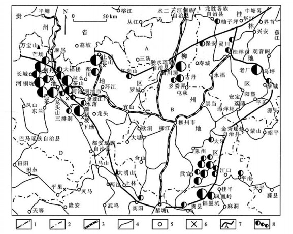
The Guizhong depression with special geotectology conditions is bounded on the north by the Guibei antiklise and the Yangtze platform, on the west by the Youjiang regenerated geosyncline, and on the east and the south by the Dayaoshan rise. In the region, most of the Pb-Zn deposits in Guangxi Zhuang Autonomous Region are distributed around the Guizhong depression. The ultralarge scale and large-moderate scale Pb-Zn ore deposits of the Hechi-Nandan metallogenetic belt lie on the boundary of the west and the northwest of the depression, the deposits of the Wuxuan-Xiangzhou metallogenetic belt lie on the boundary of the east and the southeast of the depression, and many deposits such as Binyang, Guixian, Xijikeng, Beishan and Siding lie on the boundary of the south, the north, and the northeast. In the ore district, the occurrences of the orebodies are controlled principally by different geological surfaces like the plane of unconformity, the contact of some faults, the periphery of magmatic rock, the site of sedimentary facies change, and the contact areas of diverse lithofacies. Whether within the region or within the ore district, the mineralization and distribution of Pb-Zn deposits are evidently controlled by the geological surfaces. The characteristics demonstrate that Pb-Zn deposits around the Guizhong depression are very similar to the MVT Pb-Zn deposits in the Mississippi Valley, USA(MVT). The various geological surfaces are the district of the transmission, concentration, conversion and release of energy within the earth, and are the place of the change, the activation, the transportation and the precipitation of the materials of the earth, and are the locale of the mineralization. The geological surfaces in the joint of the Guizhong depression with the peripheral geological structure units are the favorable districts of the mineralization of the MVT type lead-zinc deposits.
The Guizhong depression with special geotectology conditions is bounded on the north by the Guibei antiklise and the Yangtze platform, on the west by the Youjiang regenerated geosyncline, and on the east and the south by the Dayaoshan rise. In the region, most of the Pb-Zn deposits in Guangxi Zhuang Autonomous Region are distributed around the Guizhong depression. The ultralarge scale and large-moderate scale Pb-Zn ore deposits of the Hechi-Nandan metallogenetic belt lie on the boundary of the west and the northwest of the depression, the deposits of the Wuxuan-Xiangzhou metallogenetic belt lie on the boundary of the east and the southeast of the depression, and many deposits such as Binyang, Guixian, Xijikeng, Beishan and Siding lie on the boundary of the south, the north, and the northeast. In the ore district, the occurrences of the orebodies are controlled principally by different geological surfaces like the plane of unconformity, the contact of some faults, the periphery of magmatic rock, the site of sedimentary facies change, and the contact areas of diverse lithofacies. Whether within the region or within the ore district, the mineralization and distribution of Pb-Zn deposits are evidently controlled by the geological surfaces. The characteristics demonstrate that Pb-Zn deposits around the Guizhong depression are very similar to the MVT Pb-Zn deposits in the Mississippi Valley, USA(MVT). The various geological surfaces are the district of the transmission, concentration, conversion and release of energy within the earth, and are the place of the change, the activation, the transportation and the precipitation of the materials of the earth, and are the locale of the mineralization. The geological surfaces in the joint of the Guizhong depression with the peripheral geological structure units are the favorable districts of the mineralization of the MVT type lead-zinc deposits.


2005, 30(3): 359-365.
Abstract:
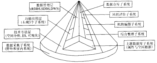
The effective approaches of improving the level of information technology application in geological surveying and mineral resource exploration are: (1) A common data platform should be established based on subject geological and mineral point-source resource databases (including spatial databases and attribute databases) according to the character of the work itself; (2) The main flow of geological surveying and mineral resource exploration can be rebuilt by making use of information system technology to put the computer-aided whole working flow into practice; (3) The "multi-S" system integration such as technical integration, network integration, data integration and application integration should be carried out, and meanwhile 3D visualization of exploration data can be realized. Therefore, it is important that the research into the theory framework, methodology and technological systems in consolidating data from geological surveying and mineral resource exploration should be taken seriously and enhanced.
The effective approaches of improving the level of information technology application in geological surveying and mineral resource exploration are: (1) A common data platform should be established based on subject geological and mineral point-source resource databases (including spatial databases and attribute databases) according to the character of the work itself; (2) The main flow of geological surveying and mineral resource exploration can be rebuilt by making use of information system technology to put the computer-aided whole working flow into practice; (3) The "multi-S" system integration such as technical integration, network integration, data integration and application integration should be carried out, and meanwhile 3D visualization of exploration data can be realized. Therefore, it is important that the research into the theory framework, methodology and technological systems in consolidating data from geological surveying and mineral resource exploration should be taken seriously and enhanced.
2005, 30(3): 366-370.
Abstract:
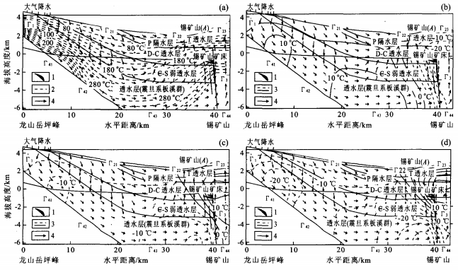
The geotherm of ore-forming fluid affects ore formation directly. This article studies the effect of annual precipitation on the geotherm of ore-forming fluid, according to the geohydrologic conditions of the central Hunan basin. Ore-forming fluid in antimony deposits in Xikuangshan was taken as an example and a representative section of Xikuangshan-Yuepingfeng was chosen. Heat and gravity driven modes of fluid movement were considered. A contrastive rainfall Q=1 200 mm/a was chosen, the distribution of the area temperature field was calculated, and the difference of two temperature fields was obtained by taking the annual precipitation of 600 mm/a, 1 800 mm/a and 2 400 mm/a compared with the temperature field of the contrastive rainfall. The simulation result shows that precipitation affects the fluid field more than the temperature field. The effect of precipitation on the temperature stays between 5%-20%. The effect of precipitation on the geotherm of ore-forming fluid is negligible.
The geotherm of ore-forming fluid affects ore formation directly. This article studies the effect of annual precipitation on the geotherm of ore-forming fluid, according to the geohydrologic conditions of the central Hunan basin. Ore-forming fluid in antimony deposits in Xikuangshan was taken as an example and a representative section of Xikuangshan-Yuepingfeng was chosen. Heat and gravity driven modes of fluid movement were considered. A contrastive rainfall Q=1 200 mm/a was chosen, the distribution of the area temperature field was calculated, and the difference of two temperature fields was obtained by taking the annual precipitation of 600 mm/a, 1 800 mm/a and 2 400 mm/a compared with the temperature field of the contrastive rainfall. The simulation result shows that precipitation affects the fluid field more than the temperature field. The effect of precipitation on the temperature stays between 5%-20%. The effect of precipitation on the geotherm of ore-forming fluid is negligible.

2005, 30(3): 371-376.
Abstract:
It is generally acknowledged that geomagnetic polarity has reversed many times in geological history. However, the cause has been unknown up to now. Based on the theory of a generator effect for the formation of the Earth's magnetic field, and the dynamic effect of a collision with a celestial body, the possibility of a geomagnetic polarity reversal caused by the collision of an asteroid with the Earth is considered in this paper. When a celestial body collides with the Earth in a direction positive or negative to the rotation of the Earth, the rotation speed of the Earth could be quickened or slowed. This could change the direction of the relative movement between Earth's core and mantle. Consequently, the direction of the vortex movement in the liquid core and the geomagnetic field may change, therefore realizing geomagnetic polarity reversal. This new concept gives a simple and clear explanation for the dynamic cause of geomagnetic polarity reversal.
It is generally acknowledged that geomagnetic polarity has reversed many times in geological history. However, the cause has been unknown up to now. Based on the theory of a generator effect for the formation of the Earth's magnetic field, and the dynamic effect of a collision with a celestial body, the possibility of a geomagnetic polarity reversal caused by the collision of an asteroid with the Earth is considered in this paper. When a celestial body collides with the Earth in a direction positive or negative to the rotation of the Earth, the rotation speed of the Earth could be quickened or slowed. This could change the direction of the relative movement between Earth's core and mantle. Consequently, the direction of the vortex movement in the liquid core and the geomagnetic field may change, therefore realizing geomagnetic polarity reversal. This new concept gives a simple and clear explanation for the dynamic cause of geomagnetic polarity reversal.


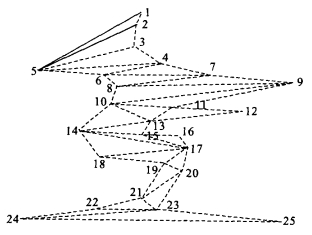
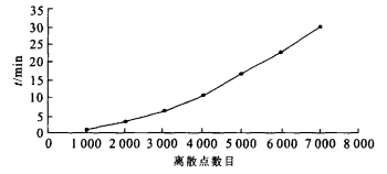
2005, 30(3): 377-380.
Abstract:
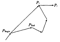
In order to form triangles with discrete points which distributed in a plane in the research of 3D stratum, this paper presents a new algorithm called automatic annular triangular cutting arithmetic (AATCA) which expands from the center to the periphery. It constructs a triangle by searching for reasonable points in the periphery place around a polygon path from the beginning of the central part of these discrete points, and updates the polygon with time. There will be hollows during the expanding, as some small areas may be skipped. But they can be divided into triangles by an existing method. Then the memory structure of data in the grid cutting process is discussed; The basic procedure and steps of AATCA are given; The time complexity of AATCA we concerning about, is between O(n) and O(n2). Efficiency is embodied in two aspects: to reduce the steps of angle calculation by only considering some polygons distributed on the periphery or on the nearside of present side; and to save time by only giving an estimation of the hollows for the expanded points. The AATCA algorithm is then applied to the Water Supply Reconstruction Project from Dongjiang to Shenzhen, which is the largest water conservancy construction project in Guangdong Province at present. The results show that the algorithm not only gives a reasonable triangular division for the polygon points but also performs efficiently.
In order to form triangles with discrete points which distributed in a plane in the research of 3D stratum, this paper presents a new algorithm called automatic annular triangular cutting arithmetic (AATCA) which expands from the center to the periphery. It constructs a triangle by searching for reasonable points in the periphery place around a polygon path from the beginning of the central part of these discrete points, and updates the polygon with time. There will be hollows during the expanding, as some small areas may be skipped. But they can be divided into triangles by an existing method. Then the memory structure of data in the grid cutting process is discussed; The basic procedure and steps of AATCA are given; The time complexity of AATCA we concerning about, is between O(n) and O(n2). Efficiency is embodied in two aspects: to reduce the steps of angle calculation by only considering some polygons distributed on the periphery or on the nearside of present side; and to save time by only giving an estimation of the hollows for the expanded points. The AATCA algorithm is then applied to the Water Supply Reconstruction Project from Dongjiang to Shenzhen, which is the largest water conservancy construction project in Guangdong Province at present. The results show that the algorithm not only gives a reasonable triangular division for the polygon points but also performs efficiently.


2005, 30(3): 381-386.
Abstract:
There are three major components in completely decomposed granite (CDG) : quartz, feldspar and clay mineral. How about the variation and the value range of their contents, especially the clay mineral? Taking samples from 18 blocks (each side 30 cm length) from 3 trial pits in Kowloon, Hong Kong, as an example, we try to solve this problem. The specimens for XRD test are cut from different zones in the blocks. The test results (involving the three components contents, percentages of kaolinite and of illite in clay size particles) are analyzed and compared. It is found that the mineral contents generally vary within a range of 10%-20%; the varied range of kaolinite content is bigger than that of illite; the change values of specimens with coarse-particle structures are larger than that of finer-particle structures; and the results from different analyzers vary to an extent. After analysis it is known that both the inhomogeneity of CDG and the experiences of analyzers mostly make the clay mineral contents change even in the same zone of one block. Furthermore, the XRD results are compared with those from statistic values via thin sections to check the variation of mineral contents. As a result, it is shown that for the mineral contents from XRD, the quartz is usually higher, the feldspar is smaller, and the clay mineral higher and smaller for different specimens. The mineral contents from XRD and thin section are different in a range of 0%-35%. Totally this research quantitatively describes the inhomogeneity of the CDG in block and trial pit sizes, which together with the identification of initial mineral or secondary clay mineral (e.g. feldspar or kaolinite, mica or vermiculite), causes the variations of the content results to a great extent.
There are three major components in completely decomposed granite (CDG) : quartz, feldspar and clay mineral. How about the variation and the value range of their contents, especially the clay mineral? Taking samples from 18 blocks (each side 30 cm length) from 3 trial pits in Kowloon, Hong Kong, as an example, we try to solve this problem. The specimens for XRD test are cut from different zones in the blocks. The test results (involving the three components contents, percentages of kaolinite and of illite in clay size particles) are analyzed and compared. It is found that the mineral contents generally vary within a range of 10%-20%; the varied range of kaolinite content is bigger than that of illite; the change values of specimens with coarse-particle structures are larger than that of finer-particle structures; and the results from different analyzers vary to an extent. After analysis it is known that both the inhomogeneity of CDG and the experiences of analyzers mostly make the clay mineral contents change even in the same zone of one block. Furthermore, the XRD results are compared with those from statistic values via thin sections to check the variation of mineral contents. As a result, it is shown that for the mineral contents from XRD, the quartz is usually higher, the feldspar is smaller, and the clay mineral higher and smaller for different specimens. The mineral contents from XRD and thin section are different in a range of 0%-35%. Totally this research quantitatively describes the inhomogeneity of the CDG in block and trial pit sizes, which together with the identification of initial mineral or secondary clay mineral (e.g. feldspar or kaolinite, mica or vermiculite), causes the variations of the content results to a great extent.