2005 Vol. 30, No. 4
Display Method:
2005, 30(4): 387-401.
 PDF 1691KB
Abstract:
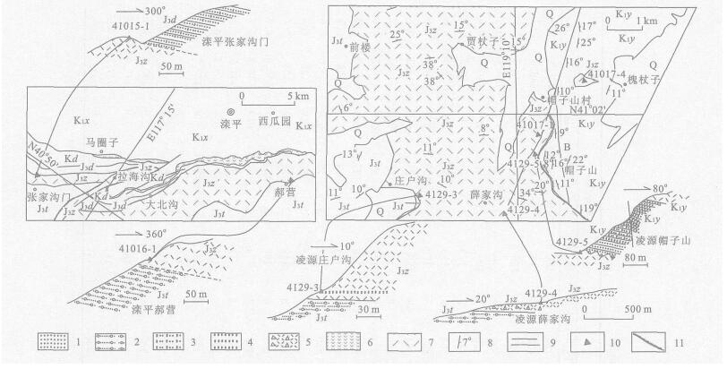
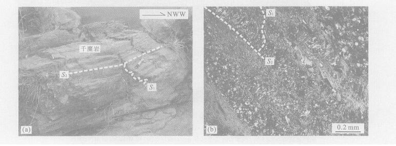
In Lingyuan region,Liaoning Province,the Zhangjiakou Formation and the Lower Mesozoic strata are in an ENE orientation,while the Yixian Formation is NNE orientated,the two formations are angular unconformity.According to the new U-Pb isotopic age analysis of zircon by LA-ICP-MS,the bottom bed of the Zhangjiakou Formation in Lingyuan is about 132 Ma,and the top bed is about 129.5-130 Ma.In Luanping region,Hebei Province,the bottom bed of the Zhangjiakou Formation is about 136 Ma,and the top bed is about 135 Ma.The Zhangjiakou Formation in the Lingyuan and Luanping regions is comparable,which reflects that the volcanic rock of the Zhangjiakou Formation from Luanping to Lingyuan becomes younger in time.The top bed of the Zhangjiakou Formation in Lingyuan has about a 5-6 Ma interval with the bottom bed of Yixian Formation,which proves that the angular unconformity of Zhangjiakou Formation and Yixian Formation is credible; suggesting that the 5-6 Ma interval period is the main period of the transition of tectonic framework in the Mesozoic in Hebei and Liaoning provinces.In the interval period,the magnetic action went up to high tide in the Mesozoic in the northeast of China.Moreover,after the interval period,the Rehe fauna developed into the erupted period,which also reflects that the interval period is an important biological interface in Hebei and Liaoning provinces.According to the isotopic age,the Dabeigou Formation in Luanping region corresponds to the upper bed of the Zhangjiakou Formation,not to the bottom bed of the Yixian Formation.
In Lingyuan region,Liaoning Province,the Zhangjiakou Formation and the Lower Mesozoic strata are in an ENE orientation,while the Yixian Formation is NNE orientated,the two formations are angular unconformity.According to the new U-Pb isotopic age analysis of zircon by LA-ICP-MS,the bottom bed of the Zhangjiakou Formation in Lingyuan is about 132 Ma,and the top bed is about 129.5-130 Ma.In Luanping region,Hebei Province,the bottom bed of the Zhangjiakou Formation is about 136 Ma,and the top bed is about 135 Ma.The Zhangjiakou Formation in the Lingyuan and Luanping regions is comparable,which reflects that the volcanic rock of the Zhangjiakou Formation from Luanping to Lingyuan becomes younger in time.The top bed of the Zhangjiakou Formation in Lingyuan has about a 5-6 Ma interval with the bottom bed of Yixian Formation,which proves that the angular unconformity of Zhangjiakou Formation and Yixian Formation is credible; suggesting that the 5-6 Ma interval period is the main period of the transition of tectonic framework in the Mesozoic in Hebei and Liaoning provinces.In the interval period,the magnetic action went up to high tide in the Mesozoic in the northeast of China.Moreover,after the interval period,the Rehe fauna developed into the erupted period,which also reflects that the interval period is an important biological interface in Hebei and Liaoning provinces.According to the isotopic age,the Dabeigou Formation in Luanping region corresponds to the upper bed of the Zhangjiakou Formation,not to the bottom bed of the Yixian Formation.


2005, 30(4): 402-412.
Abstract:
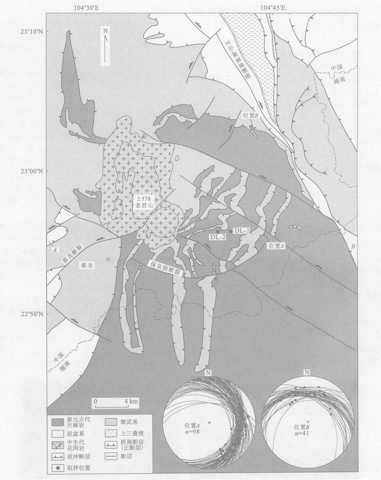
The South China Sea basin expanded firstly from Late Mesozoic to Early Cenozoic,and then at 32-17 Ma.The second stage of extension formed immediately after the first stage,and both extensions are consistent with the forming mechanism.New structural analysis and geochronological data are both inconsistent with the current models of backarc extension and extension by strike-slip fault.New data of structural styles and geochronometry in the Dulong-Song Chay metamorphic dome indicate at least two epoches of major extensional tectonics: the D2 deformation of the rising and exhumation of the dome occurred at 237-228 Ma; and the D2 deformation overprinted and re-deformed on the dome at 86-78 Ma.Of them,the D2 deformation shows a consistent forming time,extensional direction and tectonic regime amongst the Dulong-Song Chay dome,South China block and the north margin of the South China Sea basin.Regional geology shows that the north margin of the South China Sea basin belongs to the South China block.Therefore,we interpret that the Late Mesozoic to Early Cenozoic extensional tectonics occurred in the north margin of the South China Sea basin as a result of the interplate deformation of the South China block The Ailaoshan-Red River sinistral slip strengthened the Cenozoic extension in the South China Sea.
The South China Sea basin expanded firstly from Late Mesozoic to Early Cenozoic,and then at 32-17 Ma.The second stage of extension formed immediately after the first stage,and both extensions are consistent with the forming mechanism.New structural analysis and geochronological data are both inconsistent with the current models of backarc extension and extension by strike-slip fault.New data of structural styles and geochronometry in the Dulong-Song Chay metamorphic dome indicate at least two epoches of major extensional tectonics: the D2 deformation of the rising and exhumation of the dome occurred at 237-228 Ma; and the D2 deformation overprinted and re-deformed on the dome at 86-78 Ma.Of them,the D2 deformation shows a consistent forming time,extensional direction and tectonic regime amongst the Dulong-Song Chay dome,South China block and the north margin of the South China Sea basin.Regional geology shows that the north margin of the South China Sea basin belongs to the South China block.Therefore,we interpret that the Late Mesozoic to Early Cenozoic extensional tectonics occurred in the north margin of the South China Sea basin as a result of the interplate deformation of the South China block The Ailaoshan-Red River sinistral slip strengthened the Cenozoic extension in the South China Sea.


2005, 30(4): 413-420.
Abstract:
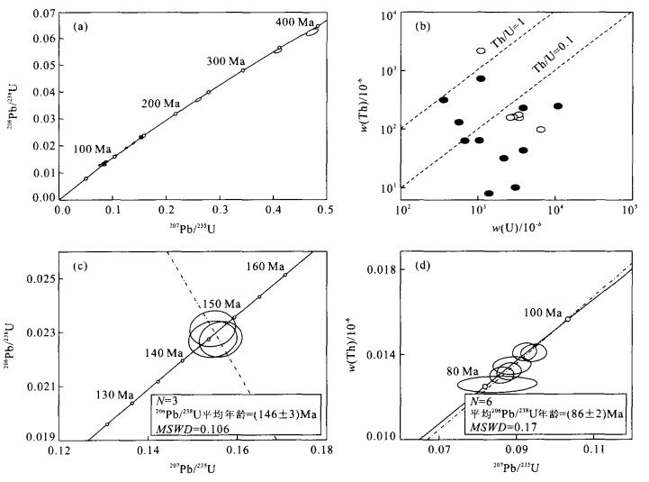
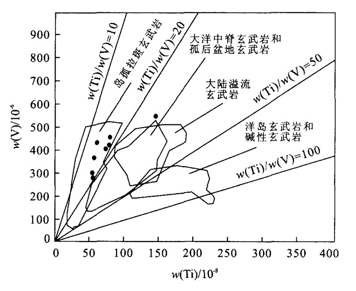
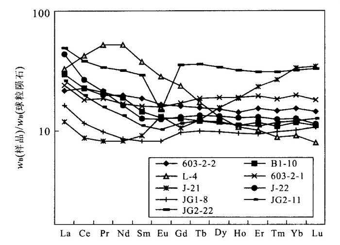
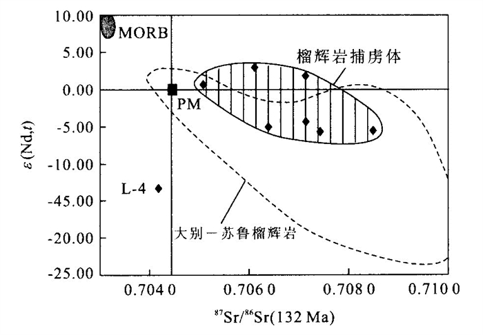
Using X-fluorecence spectrum and ICP-MS tests eclogite xenoliths components in Mesozoic intrusive complex from Xu-Huai area.The major element components are as following, SiO2: 40.88%~47.82%, TiO2: 0.78%~2.00%, Al2O3: 11.72%~16.08%, FeO (total iron) : 12.77%~20.29%, MgO: 5.23%~11.47%, CaO: 7.80%~13.11%, Na2O: 0.30%~2.09%, K2O: 0.13%~0.69%.Eclogite xenoliths have a relatively low REE abundance [ΣREE= (34.26~115.51) ×10-6] and obvious Nb, P, Zr and Ti negative anomaly.The I(Sr) and ε(Nd, t) values of eclogite xenoliths are 0.704 2~0.708 5 and-5.77~2.99 (L-4:-13.05) respectively.These characteristics indicate that their protoliths could be the tholeiitic rocks formed in an island arc environment.The Nd model ages and zircon SHRIMP U-Pb dating of the eclogite xenoliths suggest that they should belong to the basement of the North China craton (NCC).The eclogite phase metamorphism of the basement of the NCC implies that an important continental crustal thickening could have taken place in the eastern part of the NCC in early Mesozoic, which could be attributed to the deep subduction of the Yangtze craton beneath the NCC in an NW or NWW direction.
Using X-fluorecence spectrum and ICP-MS tests eclogite xenoliths components in Mesozoic intrusive complex from Xu-Huai area.The major element components are as following, SiO2: 40.88%~47.82%, TiO2: 0.78%~2.00%, Al2O3: 11.72%~16.08%, FeO (total iron) : 12.77%~20.29%, MgO: 5.23%~11.47%, CaO: 7.80%~13.11%, Na2O: 0.30%~2.09%, K2O: 0.13%~0.69%.Eclogite xenoliths have a relatively low REE abundance [ΣREE= (34.26~115.51) ×10-6] and obvious Nb, P, Zr and Ti negative anomaly.The I(Sr) and ε(Nd, t) values of eclogite xenoliths are 0.704 2~0.708 5 and-5.77~2.99 (L-4:-13.05) respectively.These characteristics indicate that their protoliths could be the tholeiitic rocks formed in an island arc environment.The Nd model ages and zircon SHRIMP U-Pb dating of the eclogite xenoliths suggest that they should belong to the basement of the North China craton (NCC).The eclogite phase metamorphism of the basement of the NCC implies that an important continental crustal thickening could have taken place in the eastern part of the NCC in early Mesozoic, which could be attributed to the deep subduction of the Yangtze craton beneath the NCC in an NW or NWW direction.


2005, 30(4): 421-429.
Abstract:
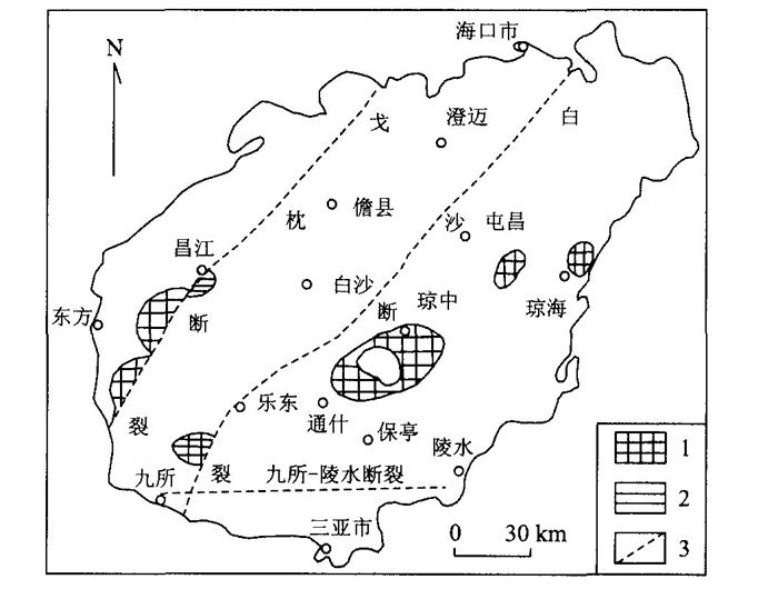
Hainan island is located at the connection place of Eurasia, India and Pacific plates, tie structure in the area is complex.An integrated analysis of stratigraphy, isotope dating and petrochemistry indicates that a Proterozoic metamorphic basement exists in Hainan island.It is divided into the southern Sanya terrain and the central-northern Wuzhishan terrain by the Jiusuo-Lingshui fault.The terrains have different basements in composition and characteristics.The Sanya terrain might be part of the South China Sea-Idochina terrain.An embryonic Wuzhishan terrain originated in the Early Proterozoic, and tectonic activity became relatively strong so that the old-land formed a stable, finished metamorphic basement in the Middle Proterozoic until it became weak in the Late Proterozoic.Active deep faults controlled the tectonic framework and evolution of the basement.The Wuzhishan terrain covers nearly all the central-northern Hainan island.
Hainan island is located at the connection place of Eurasia, India and Pacific plates, tie structure in the area is complex.An integrated analysis of stratigraphy, isotope dating and petrochemistry indicates that a Proterozoic metamorphic basement exists in Hainan island.It is divided into the southern Sanya terrain and the central-northern Wuzhishan terrain by the Jiusuo-Lingshui fault.The terrains have different basements in composition and characteristics.The Sanya terrain might be part of the South China Sea-Idochina terrain.An embryonic Wuzhishan terrain originated in the Early Proterozoic, and tectonic activity became relatively strong so that the old-land formed a stable, finished metamorphic basement in the Middle Proterozoic until it became weak in the Late Proterozoic.Active deep faults controlled the tectonic framework and evolution of the basement.The Wuzhishan terrain covers nearly all the central-northern Hainan island.


2005, 30(4): 430-436.
Abstract:
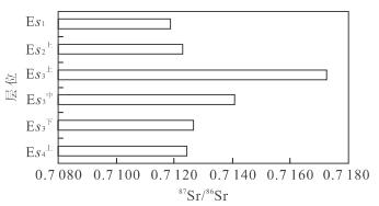
Dongpu depression is a typical saline lake basin in the Bohai Bay region.Many sets of halites have been deposited in the Shahejie Formation of Paleogene, The genesis of halites and the paleoenvironment are considered, based on the study of strontium, sulfur and oxygen isotopic composition characteristics of the Paleogene halites.The research results are as follows: (1) The halites of Paleogene of Dongpu depression were formed form continental lake water and not from the invasion of sea water.The composition of strontium isotopes was mainly controlled by the silicon-aluminum rock with a higher value of 87Sr/ 86Sr(0.720±0.005); (2) The value of δ34S((28-33) ×10-3) of Paleogene halites of Dongpu depression was higher than that of the marine evaporate (20×10-3), which indicates that the sedimentary environment was closed to sulfate and open to sulfurated hydrogen; (3) The variation of strontium and oxygen isotope compositions show that from the upper Es4 to the upper Es3 member, the paleoclimate was humid in the Dongpu depression, and rainfall gradually increased, which resulted in a decrease of δ18O and increase of 87Sr/ 86Sr; and from the upper Es3 to the Es1 member the paleoclimate became abruptly dry, which resulted in a decrease in rainfall and rapid evaporation.
Dongpu depression is a typical saline lake basin in the Bohai Bay region.Many sets of halites have been deposited in the Shahejie Formation of Paleogene, The genesis of halites and the paleoenvironment are considered, based on the study of strontium, sulfur and oxygen isotopic composition characteristics of the Paleogene halites.The research results are as follows: (1) The halites of Paleogene of Dongpu depression were formed form continental lake water and not from the invasion of sea water.The composition of strontium isotopes was mainly controlled by the silicon-aluminum rock with a higher value of 87Sr/ 86Sr(0.720±0.005); (2) The value of δ34S((28-33) ×10-3) of Paleogene halites of Dongpu depression was higher than that of the marine evaporate (20×10-3), which indicates that the sedimentary environment was closed to sulfate and open to sulfurated hydrogen; (3) The variation of strontium and oxygen isotope compositions show that from the upper Es4 to the upper Es3 member, the paleoclimate was humid in the Dongpu depression, and rainfall gradually increased, which resulted in a decrease of δ18O and increase of 87Sr/ 86Sr; and from the upper Es3 to the Es1 member the paleoclimate became abruptly dry, which resulted in a decrease in rainfall and rapid evaporation.


2005, 30(4): 437-442.
Abstract:
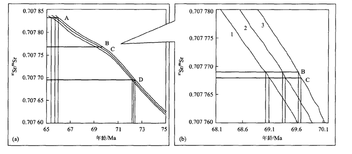
The direct numerical age calibration for sedimentary rocks is more difficult in sedimentology and stratigraphy. The long oceanic residence time of Sr (≈106 a) and the rapid mixing rate of the oceans (≈103 a) have caused the strontium isotope ratio of seawater to be globally homogeneous at any given time, as documented by identical 87Sr/ 86Sr ratios for coeval marine carbonates, and therefore, the 87Sr/86Sr ratios are the function of geological time which is the fundamental principle of strontium isotope stratigraphy (SIS) and the theoretical basis of dating marine sediments using SIS. In this paper, 87Sr/ 86Sr ratios of 4 rudist bivalves collected from a sedimentary section of the Late Cretaceous in the southern Tibet were measured. Based on the very low Mn/Sr ratio (average 0.01) of the samples, it is thought that they contain information on the original seawater strontium isotope composition. The ages of the fossils were calibrated according to the principle of strontium isotope stratigraphy. The 4 samples are located at 381, 362, 358 and 296 m, respectively, with the accumulation thickness in the section. Corresponding 87Sr/ 86Sr ratios are 0.707 832, 0.707 769, 0.707 768 and 0.707 695, respectively, and the ages calibrated are 65.68, 69.34, 69.39 and 72.32 Ma, respectively. The average error for dating by strontium isotope stratigraphy is approximately ±1 Ma. The research shows a potential value of SIS in dating marine rocks.
The direct numerical age calibration for sedimentary rocks is more difficult in sedimentology and stratigraphy. The long oceanic residence time of Sr (≈106 a) and the rapid mixing rate of the oceans (≈103 a) have caused the strontium isotope ratio of seawater to be globally homogeneous at any given time, as documented by identical 87Sr/ 86Sr ratios for coeval marine carbonates, and therefore, the 87Sr/86Sr ratios are the function of geological time which is the fundamental principle of strontium isotope stratigraphy (SIS) and the theoretical basis of dating marine sediments using SIS. In this paper, 87Sr/ 86Sr ratios of 4 rudist bivalves collected from a sedimentary section of the Late Cretaceous in the southern Tibet were measured. Based on the very low Mn/Sr ratio (average 0.01) of the samples, it is thought that they contain information on the original seawater strontium isotope composition. The ages of the fossils were calibrated according to the principle of strontium isotope stratigraphy. The 4 samples are located at 381, 362, 358 and 296 m, respectively, with the accumulation thickness in the section. Corresponding 87Sr/ 86Sr ratios are 0.707 832, 0.707 769, 0.707 768 and 0.707 695, respectively, and the ages calibrated are 65.68, 69.34, 69.39 and 72.32 Ma, respectively. The average error for dating by strontium isotope stratigraphy is approximately ±1 Ma. The research shows a potential value of SIS in dating marine rocks.

2005, 30(4): 443-450.
Abstract:
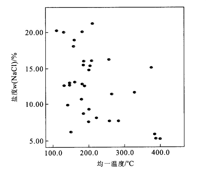
The Huize Pb-Zn ore deposits, Yunnan Province, located in the southern-center of the Sichuan-Yunnan-Guizhou Pb-Zn-Ag multimetal mineralization district, are strictly controlled by faulted zones. There has long been controversy about the sources of ore-forming fluid in these ore deposits. Calcite is one of the gangue minerals in the ores of these ore deposits. Their δ13C (PDB) values vary from -2.1×10⁻³ to -3.5×10⁻³, and their δ18O (SMOW) values are 16.7×10⁻³ to 18.6×10⁻³. There are no obvious difference in the δ13C (PDB) values and the δ18O (SMOW) values of calcites from different orebodies, different occurrences and different elevations. Besides pure liquid inclusions (L) and gas-liquid inclusions with rich liquid (L+V), three-phase inclusions containing a daughter (S+L+V) and immiscible three-phase CO2 inclusions (VCO2+LCO2+LH2O) occur in the minerals. The homogenization temperatures of all these inclusions vary from 110 ℃ to 400 ℃, and have two peaks. (87Sr/ 86Sr) 0 ratios of these ore deposits (0.713 676-0.717 012) are obviously higher than those of the mantle (0.704±0.002) and Emeishan basalt (0.703 932-0.707 818; 85 samples), and slightly higher than those of the Baizuo Formation of Huize lead-zinc ore deposits (0.708 68-0.709 31; 3 samples). But all these ratios are lower than the ones of the basement rocks (0.724 3-0.728 8; 5 samples). The (87Sr/ 86Sr) 0 ratios of these ore deposits also show that the isotopic fractionation of Sr does not occur in the ore-forming fluid during the precipitation of minerals. So, the ore-forming fluid is homogeneous and a product of different fluid mixing.Gas-liquid inclusions can be obviously separated into two groups in the range of 300-400 ℃ according to their salinities: a group with the salinity of 5%-6% (w (NaCl)) and the other group with the salinity of 12%-16% (w (NaCl)). However, the salinities of inclusions vary from 7% to 23% (w (NaCl)) in the range of 100-300 ℃, especially the range of 150-250 ℃. The pressures of faulted zones are 50×105-320×105 Pa and the pressures of overlying rocks on the ore bodies are 574×105-640×105 Pa, and those of the ore-forming processes vary from 145×105 to 754×105 Pa. When the ore-forming fluid flows into the faulted zones, its pressure sharply reduces. Then boiling occurs in the ore-forming processes. As a result of fluids mixing and boiling, the ore-forming fluid is highly concentrated. When the fluid is saturated or oversaturated, metallic minerals begin to precipitate on a great scale. So, the grade of lead-zinc ores is very high.
The Huize Pb-Zn ore deposits, Yunnan Province, located in the southern-center of the Sichuan-Yunnan-Guizhou Pb-Zn-Ag multimetal mineralization district, are strictly controlled by faulted zones. There has long been controversy about the sources of ore-forming fluid in these ore deposits. Calcite is one of the gangue minerals in the ores of these ore deposits. Their δ13C (PDB) values vary from -2.1×10⁻³ to -3.5×10⁻³, and their δ18O (SMOW) values are 16.7×10⁻³ to 18.6×10⁻³. There are no obvious difference in the δ13C (PDB) values and the δ18O (SMOW) values of calcites from different orebodies, different occurrences and different elevations. Besides pure liquid inclusions (L) and gas-liquid inclusions with rich liquid (L+V), three-phase inclusions containing a daughter (S+L+V) and immiscible three-phase CO2 inclusions (VCO2+LCO2+LH2O) occur in the minerals. The homogenization temperatures of all these inclusions vary from 110 ℃ to 400 ℃, and have two peaks. (87Sr/ 86Sr) 0 ratios of these ore deposits (0.713 676-0.717 012) are obviously higher than those of the mantle (0.704±0.002) and Emeishan basalt (0.703 932-0.707 818; 85 samples), and slightly higher than those of the Baizuo Formation of Huize lead-zinc ore deposits (0.708 68-0.709 31; 3 samples). But all these ratios are lower than the ones of the basement rocks (0.724 3-0.728 8; 5 samples). The (87Sr/ 86Sr) 0 ratios of these ore deposits also show that the isotopic fractionation of Sr does not occur in the ore-forming fluid during the precipitation of minerals. So, the ore-forming fluid is homogeneous and a product of different fluid mixing.Gas-liquid inclusions can be obviously separated into two groups in the range of 300-400 ℃ according to their salinities: a group with the salinity of 5%-6% (w (NaCl)) and the other group with the salinity of 12%-16% (w (NaCl)). However, the salinities of inclusions vary from 7% to 23% (w (NaCl)) in the range of 100-300 ℃, especially the range of 150-250 ℃. The pressures of faulted zones are 50×105-320×105 Pa and the pressures of overlying rocks on the ore bodies are 574×105-640×105 Pa, and those of the ore-forming processes vary from 145×105 to 754×105 Pa. When the ore-forming fluid flows into the faulted zones, its pressure sharply reduces. Then boiling occurs in the ore-forming processes. As a result of fluids mixing and boiling, the ore-forming fluid is highly concentrated. When the fluid is saturated or oversaturated, metallic minerals begin to precipitate on a great scale. So, the grade of lead-zinc ores is very high.


2005, 30(4): 451-458.
Abstract:
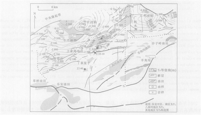
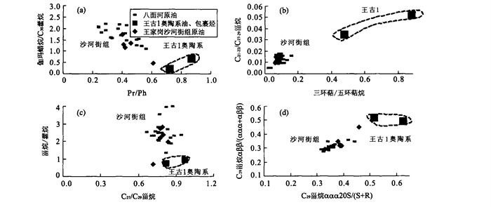
Considerable quantities of Ordovician oils were recently discovered from the burial hill in well WG 1 in the south slope of the Dongying depression, Bohai Bay basin. The oils are characterized by high content of waxy alkanes (40.84%) with a low concentration of steranes and terpanes, which are completely different from the overlying Tertiary oils of the Shahejie Formation. By removing the alkanes from the Ordovician oil with a molecular sieve and analyzing the inclusion component of well WG 1, important biomarker information was obtained, such as steranes and terpanes, which are crucial for source rock tracing.Resultsshow that the Ordovician oil and inclusion component of the well WG 1 correlated well with the source rocks of the Tertiary Kongdian Formation (Ek2) rather than that of the Shahejie Formation, suggesting potential source rocks for the Ordovician oils.Resultsof the δ13C values of the compound-specific isotope of alkanes show similar values and varying trend of the Ordovician oils to that of the Ek2 source rocks, which further proves the Ek2 mudstones to be responsible for the deep oils. The discovery of the high waxy oils of Ordovician from well WG 1 suggests the existence of a new set of deep source rocks and good potential of deep oils in the Dongying depression.
Considerable quantities of Ordovician oils were recently discovered from the burial hill in well WG 1 in the south slope of the Dongying depression, Bohai Bay basin. The oils are characterized by high content of waxy alkanes (40.84%) with a low concentration of steranes and terpanes, which are completely different from the overlying Tertiary oils of the Shahejie Formation. By removing the alkanes from the Ordovician oil with a molecular sieve and analyzing the inclusion component of well WG 1, important biomarker information was obtained, such as steranes and terpanes, which are crucial for source rock tracing.Resultsshow that the Ordovician oil and inclusion component of the well WG 1 correlated well with the source rocks of the Tertiary Kongdian Formation (Ek2) rather than that of the Shahejie Formation, suggesting potential source rocks for the Ordovician oils.Resultsof the δ13C values of the compound-specific isotope of alkanes show similar values and varying trend of the Ordovician oils to that of the Ek2 source rocks, which further proves the Ek2 mudstones to be responsible for the deep oils. The discovery of the high waxy oils of Ordovician from well WG 1 suggests the existence of a new set of deep source rocks and good potential of deep oils in the Dongying depression.


2005, 30(4): 459-466.
Abstract:
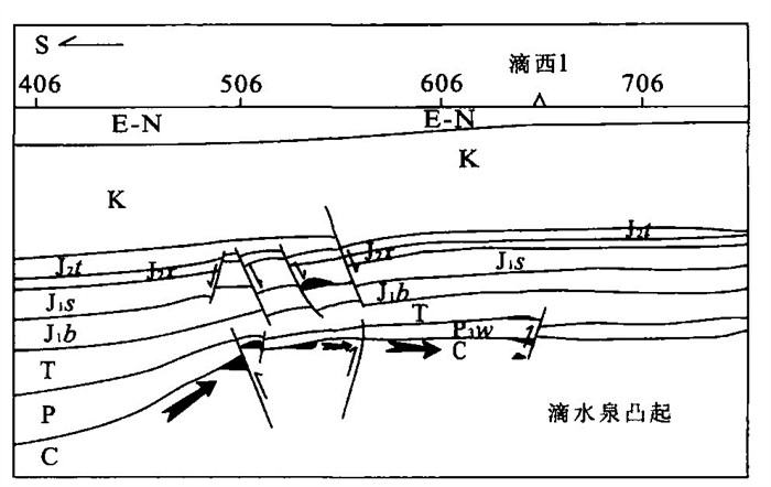
High-obliquity faults (superior to 45°) are very commonly encountered in the platform areas in Chinese western basins. Geomechanical analysis demonstrates that high-obliquity faults are produced by the compression-torsion stress field existing in Chinese western basins, and they may also be related to the stratum's brittle deformation. Static sealing pressure, which can be calculated from Poisson's coefficient, burial depth, obliquity degree of the fault, and maximum and minimum principal stresses, is used as an index of the sealing capacity or openness degree of a fault for petroleum migration. The calculation of static sealing pressure indicates that the openness degree of a fault increases with the fault's obliquity degree. The floating force decomposition illustrates that the decomposed force along the fault surface also increases with the fault's obliquity degree. Therefore, vertical, cross-formational petroleum migration via a high-obliquity fault is easier than via a low-obliquity fault. This conclusion is applied to interpret the control of high-obliquity faults on petroleum migration and occurrence in the Tarim and Junggar basins of western China.Conclusionsare: (1) Regional high-obliquity faults crossing different dynamic fluid systems control the petroleum distribution in different systems, especially as petroleum migration pass-ways for the middle-upper systems, as they are essential for pool formation in the latter; (2) Inside each dynamic fluid system, petroleum migrating along high-obliquity faults is most likely tofill the newest layer cut by the faults. The conclusions obtained have clear implications for petroleum exploration and these conclusions can be extended to other basins where high-obliquity faults exist.
High-obliquity faults (superior to 45°) are very commonly encountered in the platform areas in Chinese western basins. Geomechanical analysis demonstrates that high-obliquity faults are produced by the compression-torsion stress field existing in Chinese western basins, and they may also be related to the stratum's brittle deformation. Static sealing pressure, which can be calculated from Poisson's coefficient, burial depth, obliquity degree of the fault, and maximum and minimum principal stresses, is used as an index of the sealing capacity or openness degree of a fault for petroleum migration. The calculation of static sealing pressure indicates that the openness degree of a fault increases with the fault's obliquity degree. The floating force decomposition illustrates that the decomposed force along the fault surface also increases with the fault's obliquity degree. Therefore, vertical, cross-formational petroleum migration via a high-obliquity fault is easier than via a low-obliquity fault. This conclusion is applied to interpret the control of high-obliquity faults on petroleum migration and occurrence in the Tarim and Junggar basins of western China.Conclusionsare: (1) Regional high-obliquity faults crossing different dynamic fluid systems control the petroleum distribution in different systems, especially as petroleum migration pass-ways for the middle-upper systems, as they are essential for pool formation in the latter; (2) Inside each dynamic fluid system, petroleum migrating along high-obliquity faults is most likely tofill the newest layer cut by the faults. The conclusions obtained have clear implications for petroleum exploration and these conclusions can be extended to other basins where high-obliquity faults exist.


2005, 30(4): 467-472.
Abstract:
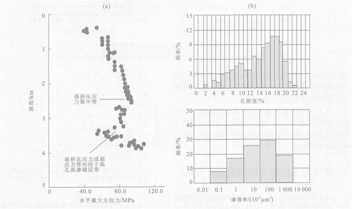
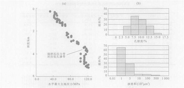
Compressive tectonic stress is extremely strong in the piedmont thrust belt of the median-west of China. The strong tectonic stress not only changes the reservoir properties but also directly controls hydrocarbon accumulation and distribution. The characteristics of shale, particularly shale resistance, can easily reflect the state of terrestrial stress. This characteristic can be used to evaluate the stress quantitatively, which was proved to be reliable by a comparison of the data from an acoustic emission experiment. Based on the in-situ stress analysis of many wells, in-situ stress distribution has been determined. The effect of terrestrial stress on reservoir property was studied and the relation of local terrestrial stress with structural styles was analyzed.Resultsshow that the high-quality reservoir always coincides with relatively low terrestrial stress belts.
Compressive tectonic stress is extremely strong in the piedmont thrust belt of the median-west of China. The strong tectonic stress not only changes the reservoir properties but also directly controls hydrocarbon accumulation and distribution. The characteristics of shale, particularly shale resistance, can easily reflect the state of terrestrial stress. This characteristic can be used to evaluate the stress quantitatively, which was proved to be reliable by a comparison of the data from an acoustic emission experiment. Based on the in-situ stress analysis of many wells, in-situ stress distribution has been determined. The effect of terrestrial stress on reservoir property was studied and the relation of local terrestrial stress with structural styles was analyzed.Resultsshow that the high-quality reservoir always coincides with relatively low terrestrial stress belts.


2005, 30(4): 473-479.
Abstract:
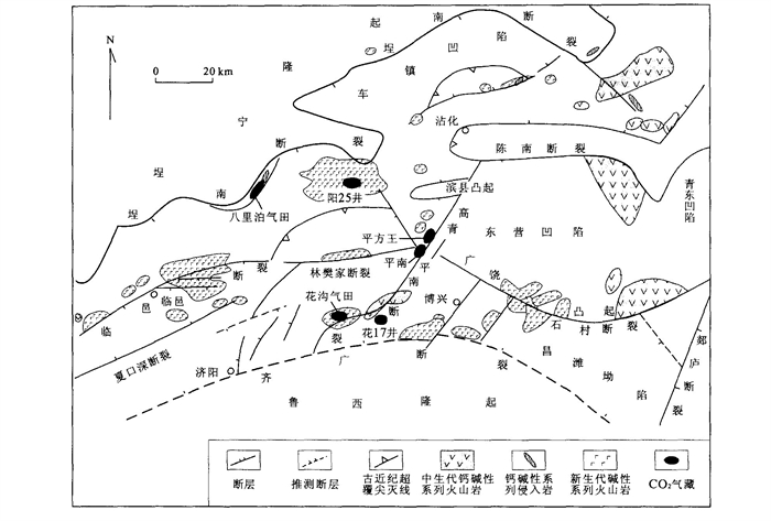
In the shallow level of the earth's crust, migration and accumulation of CO2 are similar to those of conventional hydrocarbon, and both demand rich sources, reservoirs, traps, migration system and caprocks. However, CO2 is greatly different from hydrocarbon in origin and source. By research for deep faults and igneous rocks related to CO2 gas fields, the author considers that magma is the carrier for CO2 gas migration, while the development of igneous rocks is an important sign of the synchronous fault spatio-temporal activity. The 'migration' is one of the most important elements for mantle source CO2 gas accumulation, which means that there are deep faults connected to the mantle, directly or indirectly, and fault activity must be consistent with CO2 gas migration in space and time. Thus formation of CO2 gas fields is closely related tofault and magmatic activity. Control of the fault in the formation of CO2 gas fields is as follows: (1) deep faults control CO2 gas accumulation belts; (2) the boundary faults and their derivative faults at different directions and different scales control the formation and distribution of CO2 gas fields in the basin.
In the shallow level of the earth's crust, migration and accumulation of CO2 are similar to those of conventional hydrocarbon, and both demand rich sources, reservoirs, traps, migration system and caprocks. However, CO2 is greatly different from hydrocarbon in origin and source. By research for deep faults and igneous rocks related to CO2 gas fields, the author considers that magma is the carrier for CO2 gas migration, while the development of igneous rocks is an important sign of the synchronous fault spatio-temporal activity. The 'migration' is one of the most important elements for mantle source CO2 gas accumulation, which means that there are deep faults connected to the mantle, directly or indirectly, and fault activity must be consistent with CO2 gas migration in space and time. Thus formation of CO2 gas fields is closely related tofault and magmatic activity. Control of the fault in the formation of CO2 gas fields is as follows: (1) deep faults control CO2 gas accumulation belts; (2) the boundary faults and their derivative faults at different directions and different scales control the formation and distribution of CO2 gas fields in the basin.


2005, 30(4): 480-486.
Abstract:
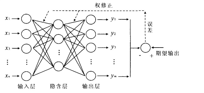
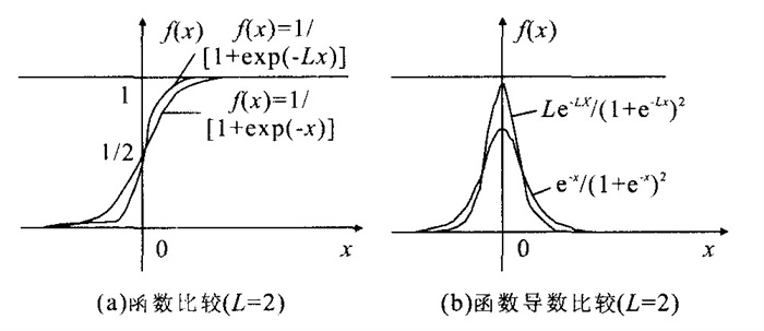
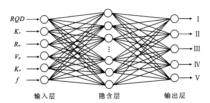
The classification of rocks surrounding a tunnel has an important significance for guiding design and construction in underground engineering. This paper introduces an artificial neural network method into the classification of these rocks. Based on traditional back propagation (BP) arithmetic, an enhanced neural network method is obtained by improving the training algorithm, transfer function and network structure. By combining the additive momentum method with the self-adjusting learning speed method, the algorithm has been improved: when the error is bigger than the upper critical limits the learning speed automatically decreases; when the error is smaller than the lower critical limits the learning speed automatically increases. Thus, the training speed can be fast yet at the same time the stability of the network can be ensured. By introducing the parameter of adjusting learning speed, the transfer process becomes more sensitive and the convergent speed becomes faster, thus, increasing the calculating precision of the training function. By giving a data range for a certain implicit layer joint model, the structure of the network is optimized; correspondingly, the functional precision is improved. The improved BP network model is tested in example classifications of some typical rocks surrounding tunnels in the Dong Shen Water Supply Reconstruction Project. The results fit well with the classification according to the code of hydraulic tunnel design in China, which indicates that this improved method has a high practical application.
The classification of rocks surrounding a tunnel has an important significance for guiding design and construction in underground engineering. This paper introduces an artificial neural network method into the classification of these rocks. Based on traditional back propagation (BP) arithmetic, an enhanced neural network method is obtained by improving the training algorithm, transfer function and network structure. By combining the additive momentum method with the self-adjusting learning speed method, the algorithm has been improved: when the error is bigger than the upper critical limits the learning speed automatically decreases; when the error is smaller than the lower critical limits the learning speed automatically increases. Thus, the training speed can be fast yet at the same time the stability of the network can be ensured. By introducing the parameter of adjusting learning speed, the transfer process becomes more sensitive and the convergent speed becomes faster, thus, increasing the calculating precision of the training function. By giving a data range for a certain implicit layer joint model, the structure of the network is optimized; correspondingly, the functional precision is improved. The improved BP network model is tested in example classifications of some typical rocks surrounding tunnels in the Dong Shen Water Supply Reconstruction Project. The results fit well with the classification according to the code of hydraulic tunnel design in China, which indicates that this improved method has a high practical application.


2005, 30(4): 487-492.
Abstract:
The material of 144 boreholes of Xixipu and Nongjijixiao soil deposits at the toe of Anlesi landslide was analyzed, types of soil were classified and the formation mechanism was analyzed based on the properties of soil deposits in a single borehole. The same type of soil was connected to one layer in a profile with several boreholes. The continuity and extent of a soil layer was determined with profiles. The results show that most of the soil deposits at the toe of Anlesi landslide slipped from the foot of the landslide, and other soil deposits are residual, colluvial, talus and alluvial. The soil deposits were formed by co-action of gravity, running water, mechanical and chemical weathering. In the soil deposits, many sliding surfaces which are plane and smooth were found, and these can be classified into two kinds. There are a few large scale sliding surfaces, which are found at some depth, and many small sliding surfaces, which occur near the surface of the soil deposits. The distribution of sliding surfaces mentioned above indicates that the soil deposits have been deformed discontinuously for a long time. Slide prevention methods, considering the geological structure underlain by gravel sand, include driven piles, rip-rap and surface drainage as a means of stabilizing the soil deposits. The driven piles should be embedded in stable ground under the gravel sand to avoid being displaced.
The material of 144 boreholes of Xixipu and Nongjijixiao soil deposits at the toe of Anlesi landslide was analyzed, types of soil were classified and the formation mechanism was analyzed based on the properties of soil deposits in a single borehole. The same type of soil was connected to one layer in a profile with several boreholes. The continuity and extent of a soil layer was determined with profiles. The results show that most of the soil deposits at the toe of Anlesi landslide slipped from the foot of the landslide, and other soil deposits are residual, colluvial, talus and alluvial. The soil deposits were formed by co-action of gravity, running water, mechanical and chemical weathering. In the soil deposits, many sliding surfaces which are plane and smooth were found, and these can be classified into two kinds. There are a few large scale sliding surfaces, which are found at some depth, and many small sliding surfaces, which occur near the surface of the soil deposits. The distribution of sliding surfaces mentioned above indicates that the soil deposits have been deformed discontinuously for a long time. Slide prevention methods, considering the geological structure underlain by gravel sand, include driven piles, rip-rap and surface drainage as a means of stabilizing the soil deposits. The driven piles should be embedded in stable ground under the gravel sand to avoid being displaced.


2005, 30(4): 493-497.
Abstract:
Study on primary consolidation of saturated soft clay under pre-loading drainage condition should be started with its drainage in nature, i.e., study the variation discipline of primary consolidation by its water content variation of soft clay through the pre-loading course, utilizing the basic property index of clay, then deduce the primary consolidation ration formula and get the theoretical calculation solution of primary consolidation (settlement), absolute primary consolidation, as well as absolute consolidation degree. The algorithmic difference compared with the traditional one is that this arithmetic is independent of pre-load (consolidation stress) and can calculate the primary consolidation effect and assess the unloading feasibility straightforwardly. It also can be draw the formula of residual primary consolidation and consolidation speed with above basic formula. By analysis with project examples, it was testified the theory was in accordance with principle with real data obtained by observation.
Study on primary consolidation of saturated soft clay under pre-loading drainage condition should be started with its drainage in nature, i.e., study the variation discipline of primary consolidation by its water content variation of soft clay through the pre-loading course, utilizing the basic property index of clay, then deduce the primary consolidation ration formula and get the theoretical calculation solution of primary consolidation (settlement), absolute primary consolidation, as well as absolute consolidation degree. The algorithmic difference compared with the traditional one is that this arithmetic is independent of pre-load (consolidation stress) and can calculate the primary consolidation effect and assess the unloading feasibility straightforwardly. It also can be draw the formula of residual primary consolidation and consolidation speed with above basic formula. By analysis with project examples, it was testified the theory was in accordance with principle with real data obtained by observation.


2005, 30(4): 498-502.
Abstract:
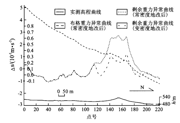
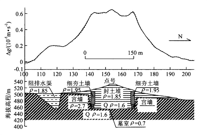
Emperor Qinshihuang mausoleum is the first emperor mausoleum in Chinese history.Although archaeologists have made many great discoveries in the mausoleum archaeology, whether the underground palace of Emperor Qinshihuang mausoleum lied under the burial tamped mound and other problems remain not really clear by now. Therefore, it is of great significance to explore the underground palace using advanced technologies in order to protect such an important cultural relic resources in science. It has been explored that digging area of the underground palace in the EW and SN directions is about 170m×145m and the western grave path has been discovered by high precision gravity survey. There would be a coffin chamber in the underground palace which is about 50m long from the east to the west and about 40m wide from the south to the north, the height of the coffin chamber is about 10m and the buried depth is about 43m; also there would be stone-made palace-wall in the surrounding of the underground palace, the central area of the palace-wall would be 145m×125m, the width of the palace-wall is about 8m, the height of the palace-wall is about 14m; and there is a thin tamped soil wall whose width is about 15m, height is about 30m on the top of stone-made palace-wall inferred from gravity anomaly definite quantity modelling. We thus consider that there exist complete set underground paleotomb architecture groups containing the coffin chamber, palace-walls, grave paths, etc. after large scale excavation under the burial tamped mound of Emperor Qinshihuang mausoleum, which provides the proof, from another side, that the underground palace lies beneath the burial tamped mound existing now.
Emperor Qinshihuang mausoleum is the first emperor mausoleum in Chinese history.Although archaeologists have made many great discoveries in the mausoleum archaeology, whether the underground palace of Emperor Qinshihuang mausoleum lied under the burial tamped mound and other problems remain not really clear by now. Therefore, it is of great significance to explore the underground palace using advanced technologies in order to protect such an important cultural relic resources in science. It has been explored that digging area of the underground palace in the EW and SN directions is about 170m×145m and the western grave path has been discovered by high precision gravity survey. There would be a coffin chamber in the underground palace which is about 50m long from the east to the west and about 40m wide from the south to the north, the height of the coffin chamber is about 10m and the buried depth is about 43m; also there would be stone-made palace-wall in the surrounding of the underground palace, the central area of the palace-wall would be 145m×125m, the width of the palace-wall is about 8m, the height of the palace-wall is about 14m; and there is a thin tamped soil wall whose width is about 15m, height is about 30m on the top of stone-made palace-wall inferred from gravity anomaly definite quantity modelling. We thus consider that there exist complete set underground paleotomb architecture groups containing the coffin chamber, palace-walls, grave paths, etc. after large scale excavation under the burial tamped mound of Emperor Qinshihuang mausoleum, which provides the proof, from another side, that the underground palace lies beneath the burial tamped mound existing now.


2005, 30(4): 503-508.
Abstract:
Small fault blocks, small sand bodies and the related subtle traps have gained greater commercial value with the growth in oil and gas exploration and development. The complicated structures of reciprocal thin layers developed in northern Songliao basin, such as small structures with altitudes 5-10m, small faults with throws 3-5m and thin sand bodies 1- 2m thick, play an important role in the accumulation of oil and gas. The meticulous depiction of these complicated structures requires a set of new techniques. We have developed some methods including high precision synthetic seismograms, coherency cubes and fault polygon information extraction, and precise spatial migration technology for 2-D migration sections, according to the geology and seismic data of the northern Songliao basin. We realized meticulous calibration of seismic-geologic horizons, meticulous interpretation of faults and 2-D poststack migration mapping, using those methods. Their application to the northern Songliao basin shows that they can improve the accuracy and efficiency of fault interpretation, such as in defining the extent of faults and the width of their fracture zones, as well as defining small faults with only 3-5m throws. Meticulous depiction of complicated structures of reciprocal thin layers in northern Songliao basin provides a base for reservoir description and the construction of precise geological models.
Small fault blocks, small sand bodies and the related subtle traps have gained greater commercial value with the growth in oil and gas exploration and development. The complicated structures of reciprocal thin layers developed in northern Songliao basin, such as small structures with altitudes 5-10m, small faults with throws 3-5m and thin sand bodies 1- 2m thick, play an important role in the accumulation of oil and gas. The meticulous depiction of these complicated structures requires a set of new techniques. We have developed some methods including high precision synthetic seismograms, coherency cubes and fault polygon information extraction, and precise spatial migration technology for 2-D migration sections, according to the geology and seismic data of the northern Songliao basin. We realized meticulous calibration of seismic-geologic horizons, meticulous interpretation of faults and 2-D poststack migration mapping, using those methods. Their application to the northern Songliao basin shows that they can improve the accuracy and efficiency of fault interpretation, such as in defining the extent of faults and the width of their fracture zones, as well as defining small faults with only 3-5m throws. Meticulous depiction of complicated structures of reciprocal thin layers in northern Songliao basin provides a base for reservoir description and the construction of precise geological models.


2005, 30(4): 509-512.
Abstract:
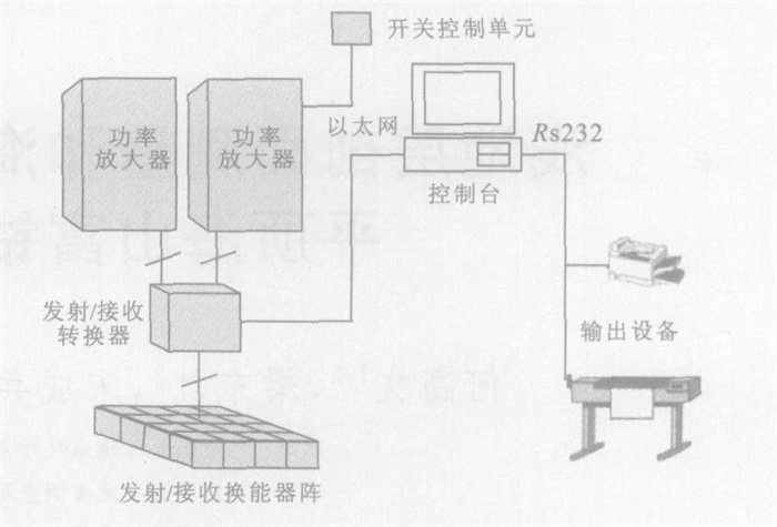
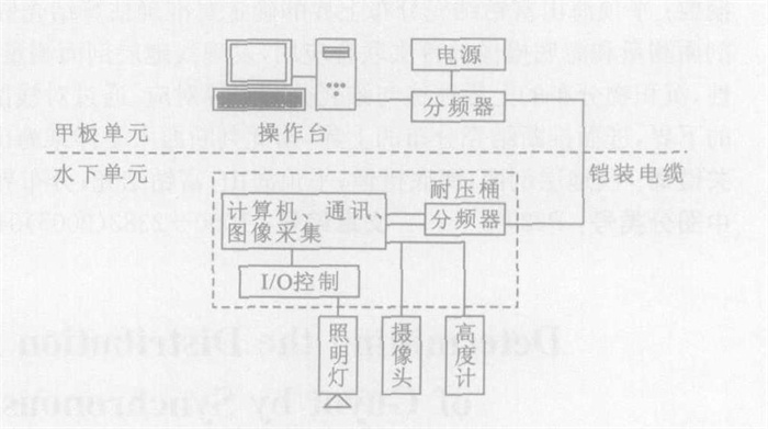
Determining the upper boundary of the cobalt-rich crust distribution of a guyot is important for estimating the mineral resources available, however, it has also long been an unsolved question. Correlations between the sub-bottom structure, revealed by sub-bottom profiling, and crust distribution can be revealed for the first time by the synchronous application of sub-bottom profiling and deep-sea video recording. The lower boundary of the sediment corresponds with the upper boundary of the crust. By analysis of these two kinds of data, the lower boundary of the sediment can be determined; therefore, the upper boundary of the crust distribution can be deduced. According to this method of analysis, the water depth of the upper boundary of crust distribution of a seamount in the western Pacific is about 1560m.
Determining the upper boundary of the cobalt-rich crust distribution of a guyot is important for estimating the mineral resources available, however, it has also long been an unsolved question. Correlations between the sub-bottom structure, revealed by sub-bottom profiling, and crust distribution can be revealed for the first time by the synchronous application of sub-bottom profiling and deep-sea video recording. The lower boundary of the sediment corresponds with the upper boundary of the crust. By analysis of these two kinds of data, the lower boundary of the sediment can be determined; therefore, the upper boundary of the crust distribution can be deduced. According to this method of analysis, the water depth of the upper boundary of crust distribution of a seamount in the western Pacific is about 1560m.