


2006 Vol. 31, No. 2
Display Method:
2006, 31(2): 143-150.
 PDF 813KB
Abstract:
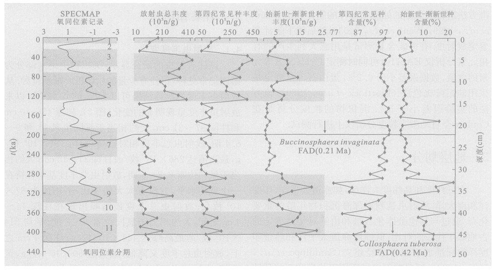
Radiolarians studied in Core 8001 of the northeast equatorial Pacific show that the first appearance datum(FAD) of Buccinospharea invaginata and Collosphaera tuberosa occur at depths of 22 and 45 cm respectively, and their FAD ages are 0.21 and 0.42 Ma. The stratigraphic framework of this core is established by the combination of the two FAD ages with the SPECMAP isotopic records in deep-sea sediments. Variations of radiolarian abundance, biogenic opal, organic carbon and grain size in this core indicate that the high radiolarian abundance during the MIS 11, 9 -8.4, 5 -3 and 1, with the high abundance of Quaternary and Eocene-Oligocene species, corresponds to the high median and mean grain sizes. Organic carbon increased during the MIS 5, reflecting the enhancing trade wind, which brought on increasing grain size in conveyed terrestrial detritus. The intensive north equatorial current led to the upwelling becoming stronger and high surface productivity, together with enhanced activity in the Antarctic bottom water. The low radiolarian abundance during the MIS 10, 8.3 -6 and 2, coinciding with the low abundances of the Quaternary and Eocene-Oligocene species, corresponds to low median and mean grain sizes. This implies the weak trade wind caused the decreasing grain size of the transported terrestrial detritus and the slack north equatorial current resulted in the weak upwelling and low surface productivity, coming along the weak activity of the Antarctic bottom water.
Radiolarians studied in Core 8001 of the northeast equatorial Pacific show that the first appearance datum(FAD) of Buccinospharea invaginata and Collosphaera tuberosa occur at depths of 22 and 45 cm respectively, and their FAD ages are 0.21 and 0.42 Ma. The stratigraphic framework of this core is established by the combination of the two FAD ages with the SPECMAP isotopic records in deep-sea sediments. Variations of radiolarian abundance, biogenic opal, organic carbon and grain size in this core indicate that the high radiolarian abundance during the MIS 11, 9 -8.4, 5 -3 and 1, with the high abundance of Quaternary and Eocene-Oligocene species, corresponds to the high median and mean grain sizes. Organic carbon increased during the MIS 5, reflecting the enhancing trade wind, which brought on increasing grain size in conveyed terrestrial detritus. The intensive north equatorial current led to the upwelling becoming stronger and high surface productivity, together with enhanced activity in the Antarctic bottom water. The low radiolarian abundance during the MIS 10, 8.3 -6 and 2, coinciding with the low abundances of the Quaternary and Eocene-Oligocene species, corresponds to low median and mean grain sizes. This implies the weak trade wind caused the decreasing grain size of the transported terrestrial detritus and the slack north equatorial current resulted in the weak upwelling and low surface productivity, coming along the weak activity of the Antarctic bottom water.


2006, 31(2): 151-158.
Abstract:
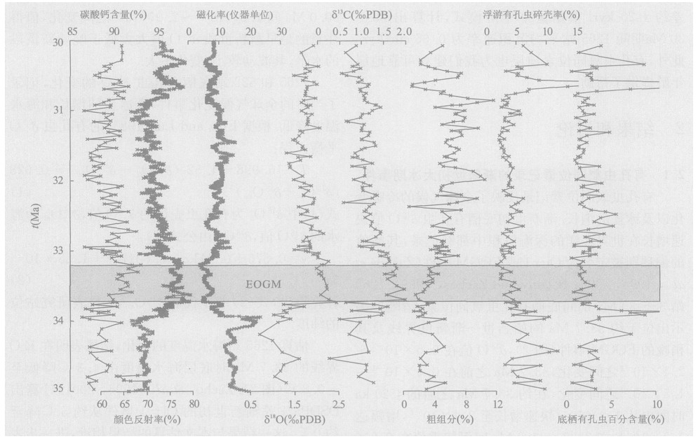
The most prominent cooling event of the Cenozoic earth surface during the long-term transition from a non-glaciated planet, or "green-house world", to a polar glaciated planet, or "ice-house world", is the earliest Oligocene glacial maximum (EOGM), immediately following the Eocene-Oligocene (E/O) boundary at about 33.7 Ma. This study analyzed benthic foraminiferal oxygen and carbon isotopes, carbonate content, coarse fraction, planktonic foraminiferal fragmentation, benthic foraminiferal percentage, and carbonate ooze grain size in samples from deep-water Site 1265, Ocean Drilling Program (ODP) Leg 208 on the Walvis Ridge, South Atlantic. The results show that the earliest Oligocene δ18O values represent the magnitude of continental ice sheets on east Antarctica and indicate a large decrease in both surface and deep water temperatures of worldwide oceans during the Eocene-Oligocene transition. Carbonate content, coarse fraction, planktonic foraminiferal fragmentation, benthic foraminiferal percentage and grain size of ODP Site 1265 indicate that carbonate content increases rapidly across the E/O boundary, reflecting the increasing of ocean paleo-productivity, the abrupt deepening in the carbonate compensation depth (CCD) and their impacts on faunas and carbonate deposition.
The most prominent cooling event of the Cenozoic earth surface during the long-term transition from a non-glaciated planet, or "green-house world", to a polar glaciated planet, or "ice-house world", is the earliest Oligocene glacial maximum (EOGM), immediately following the Eocene-Oligocene (E/O) boundary at about 33.7 Ma. This study analyzed benthic foraminiferal oxygen and carbon isotopes, carbonate content, coarse fraction, planktonic foraminiferal fragmentation, benthic foraminiferal percentage, and carbonate ooze grain size in samples from deep-water Site 1265, Ocean Drilling Program (ODP) Leg 208 on the Walvis Ridge, South Atlantic. The results show that the earliest Oligocene δ18O values represent the magnitude of continental ice sheets on east Antarctica and indicate a large decrease in both surface and deep water temperatures of worldwide oceans during the Eocene-Oligocene transition. Carbonate content, coarse fraction, planktonic foraminiferal fragmentation, benthic foraminiferal percentage and grain size of ODP Site 1265 indicate that carbonate content increases rapidly across the E/O boundary, reflecting the increasing of ocean paleo-productivity, the abrupt deepening in the carbonate compensation depth (CCD) and their impacts on faunas and carbonate deposition.


2006, 31(2): 159-164.
Abstract:
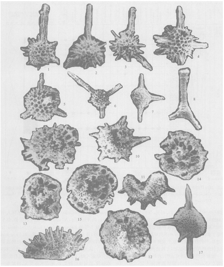
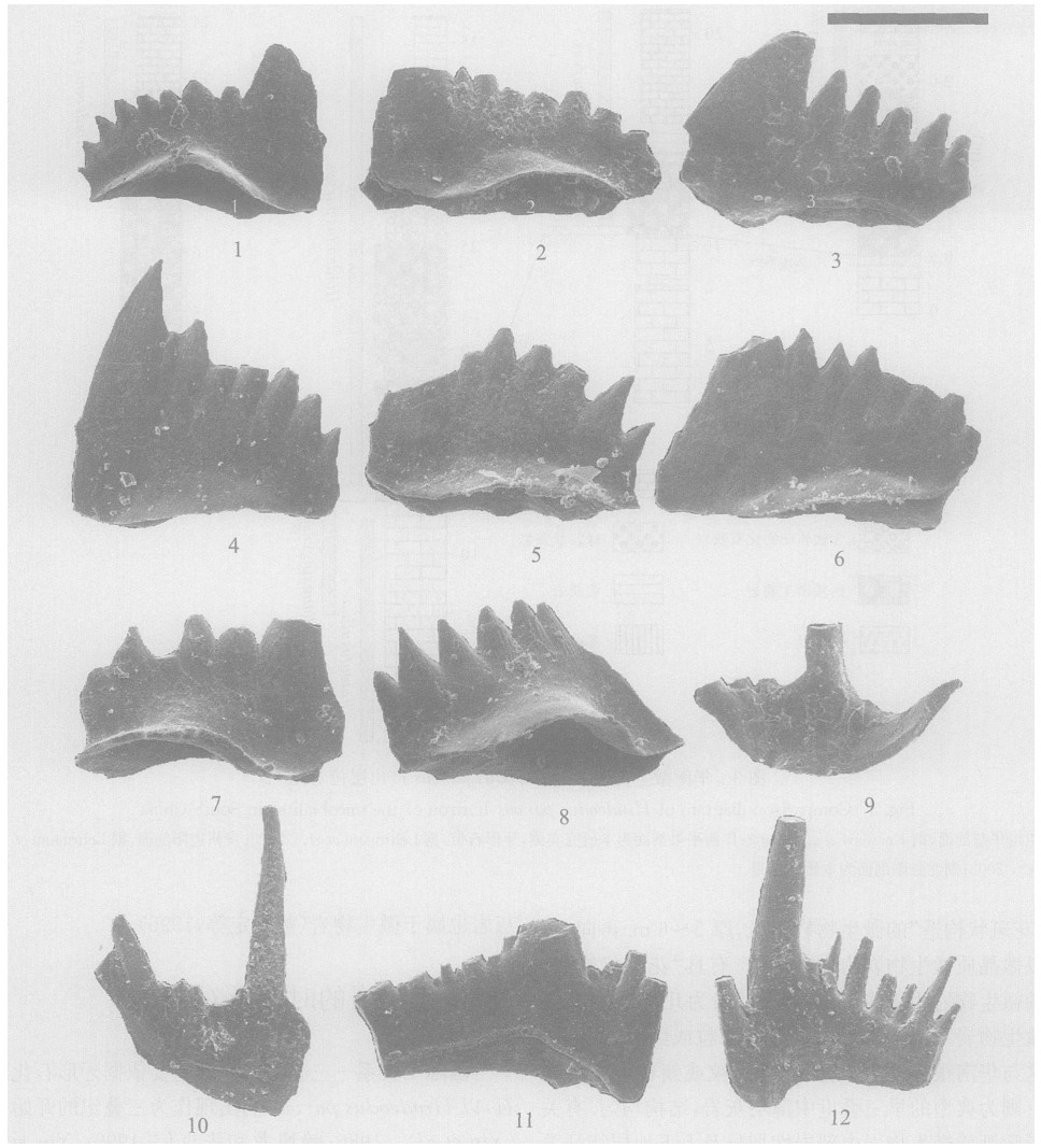
There is relatively less research for radiolarian fauna in the Meishan D Section of Changxing County, Zhejiang Province. The radiolarian species in each sample from the Meishan D Section were identified, and the individuals in 0.5 g dried samples (sieved through 300 meshes) were counted out. The research shows the abundance and diversity are closely related to sea level changes of Changhsingian age at the Meishan D Section. Where abundance and diversity reach higher values, the sea level would have peaked (e. g. maximum transgression surfaces). The abundance and diversity of radiolarians from the early Changhsingian is greater than that of the late Changhsingian age, which coincides with the opinion that the marine water was deeper in the early Changhsingian than in the late Changhsingian. This conclusion provides evidence that radiolarian abundance and diversity are indicators for investigating sea-level changes.
There is relatively less research for radiolarian fauna in the Meishan D Section of Changxing County, Zhejiang Province. The radiolarian species in each sample from the Meishan D Section were identified, and the individuals in 0.5 g dried samples (sieved through 300 meshes) were counted out. The research shows the abundance and diversity are closely related to sea level changes of Changhsingian age at the Meishan D Section. Where abundance and diversity reach higher values, the sea level would have peaked (e. g. maximum transgression surfaces). The abundance and diversity of radiolarians from the early Changhsingian is greater than that of the late Changhsingian age, which coincides with the opinion that the marine water was deeper in the early Changhsingian than in the late Changhsingian. This conclusion provides evidence that radiolarian abundance and diversity are indicators for investigating sea-level changes.

2006, 31(2): 165-170.
Abstract:
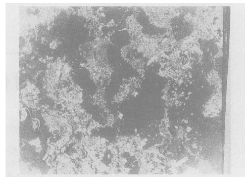
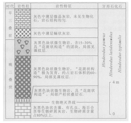
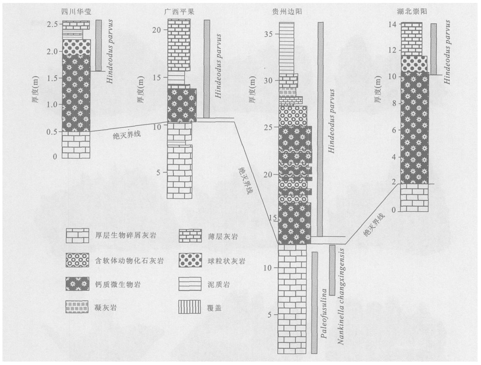
The microbialites of Chongyang in Hubei Province occur above the mass extinction line in the Late Permian reef facies. Below the boundary are the sponge reef limestone, crinoid limestone and alga-foraminifer bioclastic limestone of the Changxing Formation. The microbialites are generally composed of mid-coarse grains and microlite calcite with a structure of "graniphyic fabric" and stromatolite. The fossils discovered in the microbialites include globular cynobacteria, ostracods, micro-gastropods, bivalves, fish teeth and some problematical micro-fossils. Conodont fossils of Hindeodus parvus, H. typicalis and H. latidentatus were also found. According to the conodonts, microbialites spanned the Late Permian and Early Triassic in Chongyang. The upper part above the first occurrence of Hindeodus parvus should be attributed to the Early Triassic, and the low part to Changxingian. The sedimentary structure, fossil composition and conodont zonation of the Chongyang microbialites can be well correlated with the microbialites found in other areas of South China.
The microbialites of Chongyang in Hubei Province occur above the mass extinction line in the Late Permian reef facies. Below the boundary are the sponge reef limestone, crinoid limestone and alga-foraminifer bioclastic limestone of the Changxing Formation. The microbialites are generally composed of mid-coarse grains and microlite calcite with a structure of "graniphyic fabric" and stromatolite. The fossils discovered in the microbialites include globular cynobacteria, ostracods, micro-gastropods, bivalves, fish teeth and some problematical micro-fossils. Conodont fossils of Hindeodus parvus, H. typicalis and H. latidentatus were also found. According to the conodonts, microbialites spanned the Late Permian and Early Triassic in Chongyang. The upper part above the first occurrence of Hindeodus parvus should be attributed to the Early Triassic, and the low part to Changxingian. The sedimentary structure, fossil composition and conodont zonation of the Chongyang microbialites can be well correlated with the microbialites found in other areas of South China.

2006, 31(2): 171-174.
Abstract:
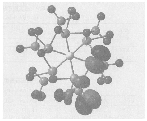
In this paper, the Gaussian98W software package and the STO-3G basis set have been adopted to study the electric charge, main atomic orbital populations of some frontier molecular orbits and covalent bond level of main atom of apatite surface on the basis of the Hartree-Fock-Roothaan (RHF) method arising from quantum chemistry ab-initio calculation. In apatite crystal structure, the composition characteristics of some frontier molecular orbits and Fermi levels are discussed by means of DV-Xα calculations. The results show that the highest occupied molecular orbits (HOMO) and the lowest unoccupied molecular orbits (LUMO) of the apatite cluster are primarily composed of Ca38 and P39, which results in the strongest covalent bone make of Ca38 and P39. Meanwhile, The structure achieves a good chemical stability. Then these results can be used to help us predict the adsorption ability and surface activity of apatite.
In this paper, the Gaussian98W software package and the STO-3G basis set have been adopted to study the electric charge, main atomic orbital populations of some frontier molecular orbits and covalent bond level of main atom of apatite surface on the basis of the Hartree-Fock-Roothaan (RHF) method arising from quantum chemistry ab-initio calculation. In apatite crystal structure, the composition characteristics of some frontier molecular orbits and Fermi levels are discussed by means of DV-Xα calculations. The results show that the highest occupied molecular orbits (HOMO) and the lowest unoccupied molecular orbits (LUMO) of the apatite cluster are primarily composed of Ca38 and P39, which results in the strongest covalent bone make of Ca38 and P39. Meanwhile, The structure achieves a good chemical stability. Then these results can be used to help us predict the adsorption ability and surface activity of apatite.


2006, 31(2): 175-181.
Abstract:
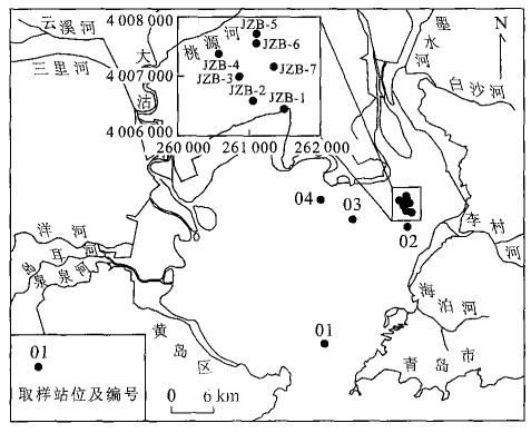
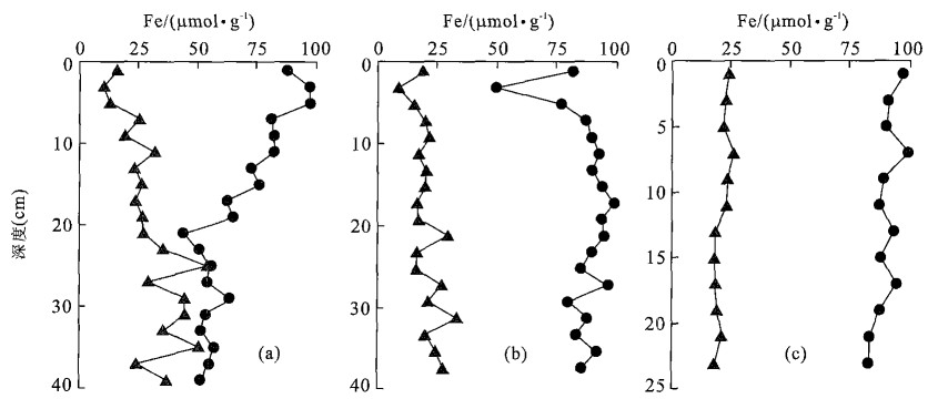
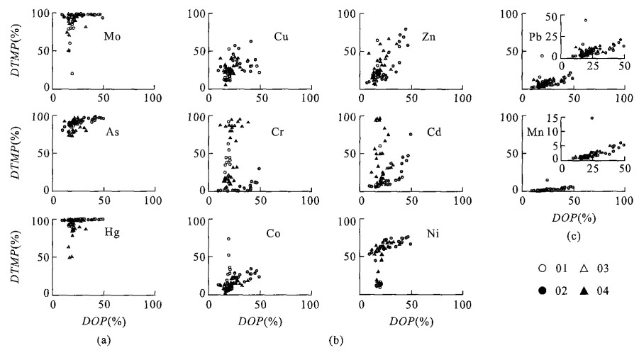
To determine the pyritization characteristics of reactive trace elements in different anoxic marine sediments, 4 undisturbed cores were sampled by a diver in May 2003. The chemical speciations of the trace elements versus depth were performed using modified sequential extraction procedures fromHuerta-Diaz and Morse (1990) .Resultsindicate that the degree of trace metal pyritization (DTMP) of most trace metals increased with increasing DOP. However, for As, Hg and Mo, the DTMP/DOP values were generally above the 1∶1 ratio line irrespective of the type of sedimentary environment involved, whereas the transition metals Cu, Zn, Cd, Cr, Co and Ni displayed a close to linear increase in DTMP with DOP and moderate incorporation into pyrite. Pb and Mn were also gradually incorporated into the pyrite phase but without reaching the DTMP levels exhibited by the above metals. These results are consistent with the chemical attributes of these different classes of trace elements. Availability of organic matter content and sedimentary rate are apparently important factors controlling the incorporation of Cu, Zn, Co, Ni, Cr, Cd and Mn into pyrite in Jiaozhou Bay. The authors conclude that special attention must be paid to during dredging activities to protect the pyrite fraction from being oxidized, especially where activity is carried out down to 20 cm in river delta sediments.
To determine the pyritization characteristics of reactive trace elements in different anoxic marine sediments, 4 undisturbed cores were sampled by a diver in May 2003. The chemical speciations of the trace elements versus depth were performed using modified sequential extraction procedures from
2006, 31(2): 182-190.
Abstract:
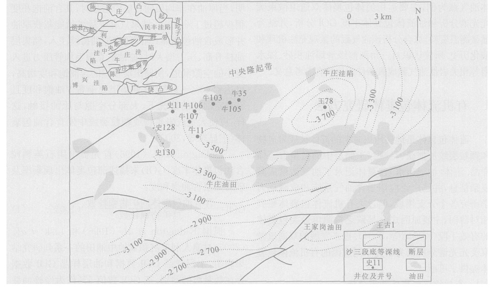
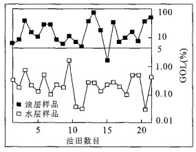
In this study, thirty six fluid inclusion samples have been systemically measured, selected from five wells in Niuzhuang oilfield in Dongying depression. The fluorescence colors of oil inclusions and GOI (quartz grains containing oil inclusions) data have also been obtained for three sand bodies, titled Niu 34-C, Niu 106-D and Shi 10-C. By the integration of these data with the DST data, the micro-charging histories of hydrocarbon in the lithologic reservoirs of Niuzhuang oilfield have been described. The results indicate that the reservoirs were mainly charged by the second order of higher mature hydrocarbon; the first charging mature oils of Shi 10-C and Niu 106-D sandy bodies were possibly swept by the second order, which would have formed the secondary oil reservoirs in the upper reservoir; the Shi 34-C sandy body reservoir was jointly charged by the early maturity and later high maturity oils. These results will be useful as a reference for revealing the hydrocarbon migration and accumulation of some other subtle reservoirs.
In this study, thirty six fluid inclusion samples have been systemically measured, selected from five wells in Niuzhuang oilfield in Dongying depression. The fluorescence colors of oil inclusions and GOI (quartz grains containing oil inclusions) data have also been obtained for three sand bodies, titled Niu 34-C, Niu 106-D and Shi 10-C. By the integration of these data with the DST data, the micro-charging histories of hydrocarbon in the lithologic reservoirs of Niuzhuang oilfield have been described. The results indicate that the reservoirs were mainly charged by the second order of higher mature hydrocarbon; the first charging mature oils of Shi 10-C and Niu 106-D sandy bodies were possibly swept by the second order, which would have formed the secondary oil reservoirs in the upper reservoir; the Shi 34-C sandy body reservoir was jointly charged by the early maturity and later high maturity oils. These results will be useful as a reference for revealing the hydrocarbon migration and accumulation of some other subtle reservoirs.


2006, 31(2): 191-200.
Abstract:
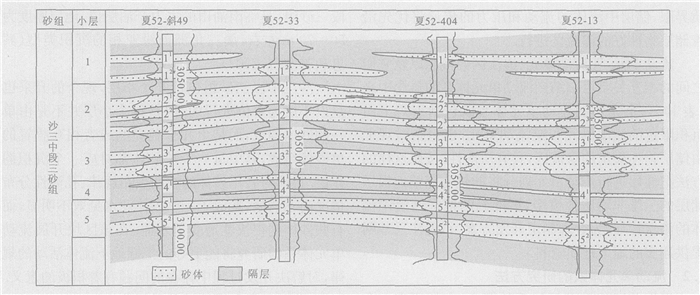
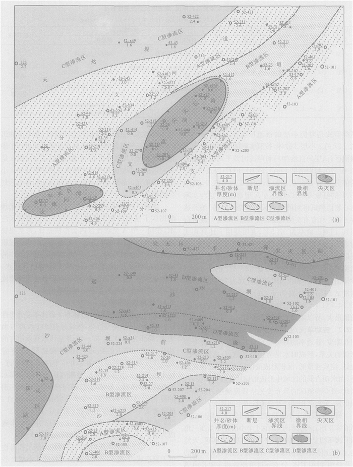
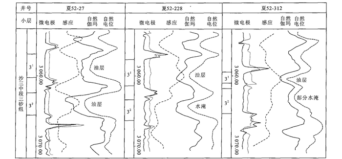
A new method for flow unit division is proposed which combines sedimentology and the physical properties of a reservoir. The flow unit system is sub-divided into three hierarchies: flow unit, sub-flow unit and seepage zone. On the basis of elaborate sandbody correlation and according to the continuously distributed insulating layers, the reservoir is divided into several individual fluid-pressure systems, namely, flow units. A flow unit is divided into several sub-flow units according to the discontinuously distributed insulating layers. Finally, a sub-flow unit or flow unit is divided into several seepage zones according to the physical properties of the reservoir. A typical prolific block in Linnan oilfield, Xia 52, was selected for this study. According to the dividing method, Xia 52 was divided into 7 flow units, 7 sub-flow units and 63 seepage zones. Such fluid unit system, which includes both frame and local detail characteristics of the reservoir, provides detail geological information for reservoir development. Good effect has been achieved by applying such method in Linnan oilfield.
A new method for flow unit division is proposed which combines sedimentology and the physical properties of a reservoir. The flow unit system is sub-divided into three hierarchies: flow unit, sub-flow unit and seepage zone. On the basis of elaborate sandbody correlation and according to the continuously distributed insulating layers, the reservoir is divided into several individual fluid-pressure systems, namely, flow units. A flow unit is divided into several sub-flow units according to the discontinuously distributed insulating layers. Finally, a sub-flow unit or flow unit is divided into several seepage zones according to the physical properties of the reservoir. A typical prolific block in Linnan oilfield, Xia 52, was selected for this study. According to the dividing method, Xia 52 was divided into 7 flow units, 7 sub-flow units and 63 seepage zones. Such fluid unit system, which includes both frame and local detail characteristics of the reservoir, provides detail geological information for reservoir development. Good effect has been achieved by applying such method in Linnan oilfield.

2006, 31(2): 201-208.
Abstract:
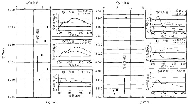
Changes in hydrocarbon-water contact record the history of the adjustment, reconstruction and even destruction of reservoirs. Restoring the positions of paleohydrocarbon-water contact of reservoirs in different periods of geological history can determine the timing of migration, accumulation of hydrocarbon and reservoir adjustment. This can aid in understanding the laws governing the formation and distribution of reservoirs and assist in the evaluation of petroleum resources. The paleohydrocarbon-water contact of the typical reservoirs in northern Tarim was restored using the methods of GOI and QGF. The results show that the paleohydrocarbon-water contact of Silurian reservoirs in the northern Tarim is lower than the bottom of the current asphalt sandstone. That is, there is a paleo-oil column below the current asphalt sandstone and the oil in it has migrated into the structural high and has not left the asphalt during the period of the reservoir's destruction. So, the thickness of asphalt sandstone is less than the height of the paleo-oil column, which means the szle of paloreserviores is bigger than that of current reserviors.
Changes in hydrocarbon-water contact record the history of the adjustment, reconstruction and even destruction of reservoirs. Restoring the positions of paleohydrocarbon-water contact of reservoirs in different periods of geological history can determine the timing of migration, accumulation of hydrocarbon and reservoir adjustment. This can aid in understanding the laws governing the formation and distribution of reservoirs and assist in the evaluation of petroleum resources. The paleohydrocarbon-water contact of the typical reservoirs in northern Tarim was restored using the methods of GOI and QGF. The results show that the paleohydrocarbon-water contact of Silurian reservoirs in the northern Tarim is lower than the bottom of the current asphalt sandstone. That is, there is a paleo-oil column below the current asphalt sandstone and the oil in it has migrated into the structural high and has not left the asphalt during the period of the reservoir's destruction. So, the thickness of asphalt sandstone is less than the height of the paleo-oil column, which means the szle of paloreserviores is bigger than that of current reserviors.


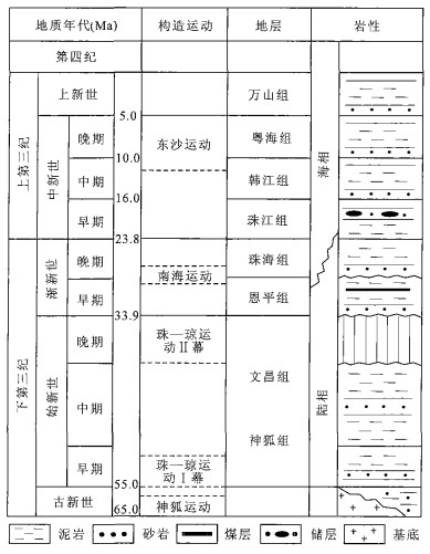
Discovery and Recognition of the Central Diapiric Zone in Baiyun Depression, Pearl River Mouth Basin
2006, 31(2): 209-213.
Abstract:
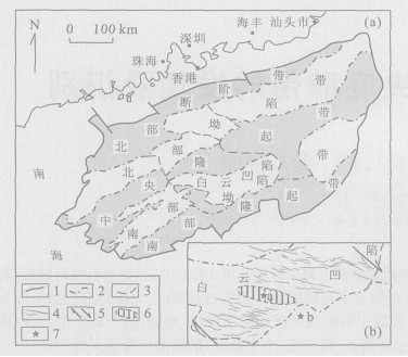
The Baiyun depression is a sub-unit of the Pearl River Mouth basin. In the center of this depression, fuzzy zones on 2D seismic profiles and low magnetic anomalies have been analyzed. A diapiric zone has been revealed, with a WNW directional distribution, about 1 000 km2 planar area and about 8 km most pierced thickness. The diapiric structures display various types such as a turtleback-like arch, weak piercing, gas-chimney, fault (or crack) and seabed pit, originated in two huge mud-rich strata the Wenchang Formation (Eocene) and the Enping Formation (Upper Eocene-Lower Oligocene). There are deep-lake facies in the rift period of the depression; the secondary is the Zhujiang Formation (Lower Miocene) and Hanjiang Formation (Middle Miocene), which have shallow or deep-marine facies in down-warping period. In the depression, factors are favorable for diapirism such as rapid subsidence, fine-grain sediment mainly filling, and dextral tenso-shear stress-field since the Cenozoic. The structures indicate a high temperature-overpressure system ever developed. Closely associated and abundant bright-spots show natural gas has migrated vertically, and a dynamic system has existed for petroleum transported from the Paleogene to the Neogene and Quaternary.
The Baiyun depression is a sub-unit of the Pearl River Mouth basin. In the center of this depression, fuzzy zones on 2D seismic profiles and low magnetic anomalies have been analyzed. A diapiric zone has been revealed, with a WNW directional distribution, about 1 000 km2 planar area and about 8 km most pierced thickness. The diapiric structures display various types such as a turtleback-like arch, weak piercing, gas-chimney, fault (or crack) and seabed pit, originated in two huge mud-rich strata the Wenchang Formation (Eocene) and the Enping Formation (Upper Eocene-Lower Oligocene). There are deep-lake facies in the rift period of the depression; the secondary is the Zhujiang Formation (Lower Miocene) and Hanjiang Formation (Middle Miocene), which have shallow or deep-marine facies in down-warping period. In the depression, factors are favorable for diapirism such as rapid subsidence, fine-grain sediment mainly filling, and dextral tenso-shear stress-field since the Cenozoic. The structures indicate a high temperature-overpressure system ever developed. Closely associated and abundant bright-spots show natural gas has migrated vertically, and a dynamic system has existed for petroleum transported from the Paleogene to the Neogene and Quaternary.


Dominant Migration Pathway and Its Control on Oil-Gas Migration in the Northern Edge of Qaidam Basin
2006, 31(2): 214-220.
Abstract:
Dominant migration pathway is an effective method for predicting hydrocarbon migration and favorable traps. Dominant migration pathway can be mainly divided into four models including predominances caused respectively by porosity and permeability difference relative to surrounding rocks, excursion of sedimentation center of caprocks, fluid pressure, or fault obliquity. Based on studies on sandbody distribution, paleo-fluid potential in pool-forming period, fault obliquity and excursion of sedimentation center of caprocks, the distribution and controlling on hydrocarbon migration of every types of dominant migration pathways in the northern edge of Qaidam basin were expatiated. And then hydrocarbon migration and favorable traps in the northern edge of Qaidam basin were predicted by integrated the controlling on hydrocarbon of different types of dominant pathways. The study results show that Lenghu-Nanbaxian structural belt is the most favorable accumulation zone for it is located in the area of four types dominant pathways, followed by Eboliang-Hulushan structural belt, and structural heights of No.7 Lenghu structure and Hulushan structure are the most favorable exploration targets.
Dominant migration pathway is an effective method for predicting hydrocarbon migration and favorable traps. Dominant migration pathway can be mainly divided into four models including predominances caused respectively by porosity and permeability difference relative to surrounding rocks, excursion of sedimentation center of caprocks, fluid pressure, or fault obliquity. Based on studies on sandbody distribution, paleo-fluid potential in pool-forming period, fault obliquity and excursion of sedimentation center of caprocks, the distribution and controlling on hydrocarbon migration of every types of dominant migration pathways in the northern edge of Qaidam basin were expatiated. And then hydrocarbon migration and favorable traps in the northern edge of Qaidam basin were predicted by integrated the controlling on hydrocarbon of different types of dominant pathways. The study results show that Lenghu-Nanbaxian structural belt is the most favorable accumulation zone for it is located in the area of four types dominant pathways, followed by Eboliang-Hulushan structural belt, and structural heights of No.7 Lenghu structure and Hulushan structure are the most favorable exploration targets.


2006, 31(2): 221-228.
Abstract:
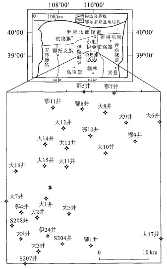
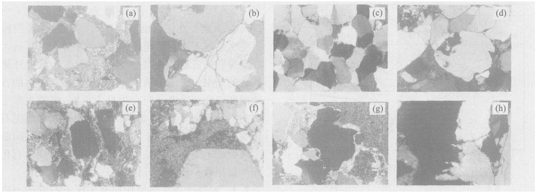
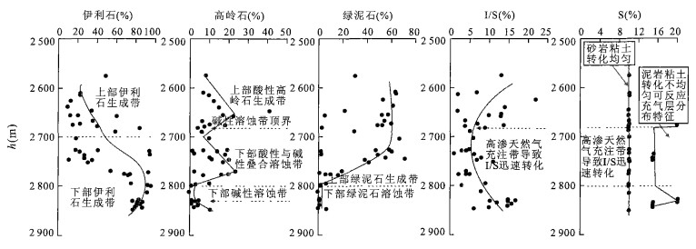
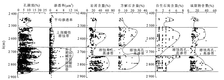
The main factors controlling the quality of the sandstone reservoirs of the Xiashihezi and Shanxi formations in Tabamiao area, Ordos basin, are discussed through the synthetic investigation of petrologic observation of thin sections, the restoration of burial history, fluid inclusion measurement, a comparison of formation water chemistry with clay minerals and porosity, and a statistical analysis of permeability. The study reveals that at about the end of the Early Cretaceous, the primary porosity of the sandstones seemed to be almost lost due to deep burial (about 4 500 m) and strong compaction, causing the soft debris deformation to fill the intergranular pores. However, the acidic dissolution of carbonate minerals and some feldspar, which occurred during the middle diagenesis, produced some secondary pores. During the late diagenetic stage, the alkaline dissolution raised in quartz grains and aluminosilic debris of the same sandstones to form a superimposed secondary porous belt, which has been thought to be the main controlling factor on reservoir quality. The profile of clay mineral contents coupled with formation water chemistry, porosity and permeability, contents of debris, calcite, authigenic quartz and matrix clearly indicates that there is a very important contact at about 2 670 m. At this depth, an acidic dissolution in sandstones developed, and beneath this depth, the sandstones underwent the late alkaline dissolution which superimposed on the early acidic dissolution. The strongest dissolution belt occurs between 2 670 and 2 740 m, and was filled with natural gases. Attention should therefore be paid to this belt in future exploration and development.
The main factors controlling the quality of the sandstone reservoirs of the Xiashihezi and Shanxi formations in Tabamiao area, Ordos basin, are discussed through the synthetic investigation of petrologic observation of thin sections, the restoration of burial history, fluid inclusion measurement, a comparison of formation water chemistry with clay minerals and porosity, and a statistical analysis of permeability. The study reveals that at about the end of the Early Cretaceous, the primary porosity of the sandstones seemed to be almost lost due to deep burial (about 4 500 m) and strong compaction, causing the soft debris deformation to fill the intergranular pores. However, the acidic dissolution of carbonate minerals and some feldspar, which occurred during the middle diagenesis, produced some secondary pores. During the late diagenetic stage, the alkaline dissolution raised in quartz grains and aluminosilic debris of the same sandstones to form a superimposed secondary porous belt, which has been thought to be the main controlling factor on reservoir quality. The profile of clay mineral contents coupled with formation water chemistry, porosity and permeability, contents of debris, calcite, authigenic quartz and matrix clearly indicates that there is a very important contact at about 2 670 m. At this depth, an acidic dissolution in sandstones developed, and beneath this depth, the sandstones underwent the late alkaline dissolution which superimposed on the early acidic dissolution. The strongest dissolution belt occurs between 2 670 and 2 740 m, and was filled with natural gases. Attention should therefore be paid to this belt in future exploration and development.


2006, 31(2): 229-236.
Abstract:
The Pearl River Mouth basin is one of the most important offshore basins in China. Petroleum exploration is being carried out in the deep water area of the basin. Well tests indicate that the pore pressure is normal in the shallow water area. The hydrocarbon migration and geopressure distribution in the deep water area are poorly understood at present. These issues have been considered using geological data and basin modelling. The modeled results indicate that pressure accumulation and release, and fluids migration have a close relationship with structural movement. On the basis of our investigation, the following conclusions have been drawn: (1) At least three episodic accumulations and release of pressure occurred in the Cenozoic. The pressure release and associated hydrocarbon migration occurred primarily during the Dongsha Movement, when most of the overpressure was released to normal pore pressure except for some overpressure in the deep water area. (2) Both the measured pressure and the modeling results indicate that pressure is normal in the shallow water area and is abnormally high in the deep water area at present stratigraphy. Difference of pressure distribution is caused by lithologies and facies, because of the high percentage of mudstone deposited in the deep water and the high percentage of sandstone in shallow water. (3) The hydrocarbon migrated to the shallow and deep water areas along faults. Because of the high ratio of sandstone in the shallow water and high ratio of mudstone in the deep water area, the hydrocarbon scattered into the sandstone more easily in the shallow water area, so large oil & gas fields appear to form more easily in the deep water area.
The Pearl River Mouth basin is one of the most important offshore basins in China. Petroleum exploration is being carried out in the deep water area of the basin. Well tests indicate that the pore pressure is normal in the shallow water area. The hydrocarbon migration and geopressure distribution in the deep water area are poorly understood at present. These issues have been considered using geological data and basin modelling. The modeled results indicate that pressure accumulation and release, and fluids migration have a close relationship with structural movement. On the basis of our investigation, the following conclusions have been drawn: (1) At least three episodic accumulations and release of pressure occurred in the Cenozoic. The pressure release and associated hydrocarbon migration occurred primarily during the Dongsha Movement, when most of the overpressure was released to normal pore pressure except for some overpressure in the deep water area. (2) Both the measured pressure and the modeling results indicate that pressure is normal in the shallow water area and is abnormally high in the deep water area at present stratigraphy. Difference of pressure distribution is caused by lithologies and facies, because of the high percentage of mudstone deposited in the deep water and the high percentage of sandstone in shallow water. (3) The hydrocarbon migrated to the shallow and deep water areas along faults. Because of the high ratio of sandstone in the shallow water and high ratio of mudstone in the deep water area, the hydrocarbon scattered into the sandstone more easily in the shallow water area, so large oil & gas fields appear to form more easily in the deep water area.


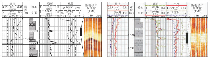
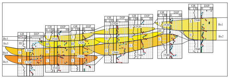
2006, 31(2): 237-244.
Abstract:
The recognition and contrast of bed sets in parasequence is difficult in terrestrial basin high-resolution sequence stratigraphy. This study puts forward new methods for bed set boundary identification and contrast on the basis of manifold logging data. This paper considers the formation causes of calcareous interbeds, shale resistivity differences and the relation of reservoir resistivity to altitude, on the basis of log curve morphological characteristics, core observation, founding slice, X-diffraction and scanning electron microscopy. The results show that the thickness of calcareous interbeds is between 0.5 m and 2 m and its thickness is increased on weathering crusts and faults. Calcareous interbeds occur at the bottom of a distributary channel and the top of a distributary mouth bar. Lower resistivity shale (4-5 Ω·m) and higher resistivity shale (>10 Ω·m) reflect differences in sediment fountain or sediment microfacies. Reservoir resistivity increases with altitude. So calcareous interbeds may become a symbol of recognition and isochronous contrast bed sets, and shale resistivity differences may confirm the stack relation and connectivity of bed sets. On the basis, the author founds the high-resolution chronostratigraphic framework of Xi-1 number in Shinan area in Junggar basin, and confirmed the connectivity of bed sets and oil-water contact. In this chronostratigraphic framework, the growth order, stack mode and space shape of bed sets are a qualitative and quantitative token.
The recognition and contrast of bed sets in parasequence is difficult in terrestrial basin high-resolution sequence stratigraphy. This study puts forward new methods for bed set boundary identification and contrast on the basis of manifold logging data. This paper considers the formation causes of calcareous interbeds, shale resistivity differences and the relation of reservoir resistivity to altitude, on the basis of log curve morphological characteristics, core observation, founding slice, X-diffraction and scanning electron microscopy. The results show that the thickness of calcareous interbeds is between 0.5 m and 2 m and its thickness is increased on weathering crusts and faults. Calcareous interbeds occur at the bottom of a distributary channel and the top of a distributary mouth bar. Lower resistivity shale (4-5 Ω·m) and higher resistivity shale (>10 Ω·m) reflect differences in sediment fountain or sediment microfacies. Reservoir resistivity increases with altitude. So calcareous interbeds may become a symbol of recognition and isochronous contrast bed sets, and shale resistivity differences may confirm the stack relation and connectivity of bed sets. On the basis, the author founds the high-resolution chronostratigraphic framework of Xi-1 number in Shinan area in Junggar basin, and confirmed the connectivity of bed sets and oil-water contact. In this chronostratigraphic framework, the growth order, stack mode and space shape of bed sets are a qualitative and quantitative token.


2006, 31(2): 245-249.
Abstract:
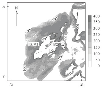
The South China Sea has long been regarded as abundant in the resource of gas hydrate. Having integrated the data of the depth of the overall South China Sea,and that of geological conditions such as geothermal gradient and bottom water temperature,a Visual Basic.Net program is proposed to compute the thickness of the gas hydrate stability zone and potential volume of gas hydrate in the region. We find that in area 1 gas hydrate may exist,and the maximum thickness of the gas hydrate stability zone is about 400 m when geothermal gradient is 0.06 ℃/m. The distribution of gas hydrate is very equal,the trend is being thicker from outside to inner. But in area 2 there is a lack of gas hydrate because of the depth,geothermal gradient and other factors,and the potential volume of gas hydrate is about 0.55×10⁴ km3. When the geothermal gradient is random,the potential volume of gas hydrate is about 0.57×10⁴ km3. Through getting the different geothermal gradients,we can calculate that the potential volume of gas hydrate in the South China Sea is about 0.6×10⁴ km3.
The South China Sea has long been regarded as abundant in the resource of gas hydrate. Having integrated the data of the depth of the overall South China Sea,and that of geological conditions such as geothermal gradient and bottom water temperature,a Visual Basic.Net program is proposed to compute the thickness of the gas hydrate stability zone and potential volume of gas hydrate in the region. We find that in area 1 gas hydrate may exist,and the maximum thickness of the gas hydrate stability zone is about 400 m when geothermal gradient is 0.06 ℃/m. The distribution of gas hydrate is very equal,the trend is being thicker from outside to inner. But in area 2 there is a lack of gas hydrate because of the depth,geothermal gradient and other factors,and the potential volume of gas hydrate is about 0.55×10⁴ km3. When the geothermal gradient is random,the potential volume of gas hydrate is about 0.57×10⁴ km3. Through getting the different geothermal gradients,we can calculate that the potential volume of gas hydrate in the South China Sea is about 0.6×10⁴ km3.

2006, 31(2): 250-256.
Abstract:
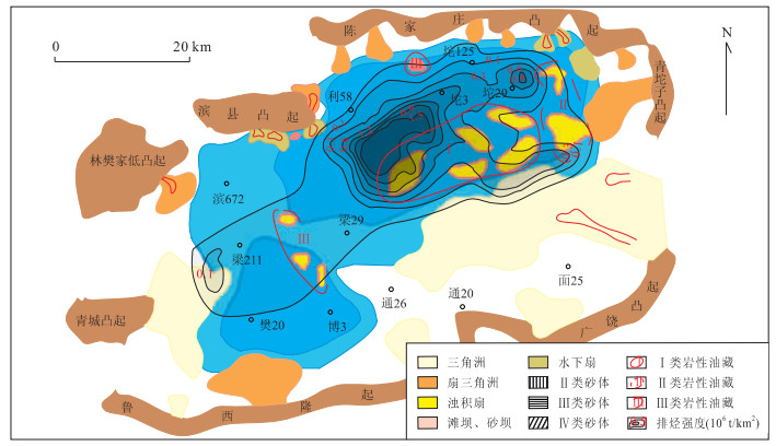
Jiyang sub-basin is the most important area of subtle traps in China. Exploration in recent years has shown that the petroliferous property of the sand lens reservoir is quite different and the accumulation mechanism of lithologic reservoir is not clearly comprehended, restricting further exploration. A statistical analysis of the petroliferous properties of 145 lens reservoirs in Dongying depression was carried out, as well as the analysis of typical lenticular pools and NMR modeling experiments.Resultsshow that structural and sedimentary factors, and hydrocarbon generation and expulsion conditions of the surrounding source rock, as well as reservoir properties, are the main controlling factors for lens reservoir formation. Lens reservoir formation depends primarily upon the balance of accumulation power and resistance. When the hydrocarbon supply thresholds have been exceeded the accumulation power is bigger than the resistance at the sand and mud interface, so oil/gas would possibly accumulate to the lens. Accumulation power is made up of different capillary pressures between source and reserve, and hydrocarbon diffusion, as well as hydrocarbon volume expansion. Resistance is the osmotic resistance of flowing liquid. The better the three accumulation controlling factors are matched, the higher the petroliferous property. By applying the research results, the lens reservoir distribution of the third member of the Neogene Shahejie Formation in Dongying depression is forecast.
Jiyang sub-basin is the most important area of subtle traps in China. Exploration in recent years has shown that the petroliferous property of the sand lens reservoir is quite different and the accumulation mechanism of lithologic reservoir is not clearly comprehended, restricting further exploration. A statistical analysis of the petroliferous properties of 145 lens reservoirs in Dongying depression was carried out, as well as the analysis of typical lenticular pools and NMR modeling experiments.Resultsshow that structural and sedimentary factors, and hydrocarbon generation and expulsion conditions of the surrounding source rock, as well as reservoir properties, are the main controlling factors for lens reservoir formation. Lens reservoir formation depends primarily upon the balance of accumulation power and resistance. When the hydrocarbon supply thresholds have been exceeded the accumulation power is bigger than the resistance at the sand and mud interface, so oil/gas would possibly accumulate to the lens. Accumulation power is made up of different capillary pressures between source and reserve, and hydrocarbon diffusion, as well as hydrocarbon volume expansion. Resistance is the osmotic resistance of flowing liquid. The better the three accumulation controlling factors are matched, the higher the petroliferous property. By applying the research results, the lens reservoir distribution of the third member of the Neogene Shahejie Formation in Dongying depression is forecast.


2006, 31(2): 257-265.
Abstract:
The features of the faults in the center and north of the Tibetan plateau are discussed, based on two super-wide band magnetotulleric (MT) sounding profiles which belong to INDEPTH (Ⅲ) -MT and were finished between 1998 and 1999: one is from Deqing to Longweicuo (named line 500), the other is from Naqu to Golmud (named line 600). This work assists research on the collision and subduction mode between the India and Asia plates. The MT result shows that there are series of deep faults, F1 to F10, in the center and north Tibetan plateau. Of these faults, F2 is an earlier main fault which leans to the north, and F1 is a later main overriding fault. Jiali deep fault zone, which has a very complex space structure, is composed of these two faults. F3, F4 and F5 are super-deep faults. They are high angle faults and lean a little to the south. The main fault zone of Bangong-Nujiang suture is composed of these three faults. Because of later activity in the structure, several shallow faults formed in the upper crust within the Bangong-Nujiang suture. Tanggula fault zone is composed of two main faults, F6 and F7, and a series of sub-faults. The shallow segments of the main faults are in high angle and the deep segments of main faults are in low angle. These two faults lean to the south generally and extend into the lower crust. Jinshajiang suture is composed of Jinshajiang fault (F8) and Kekexili fault (F9), and there is a series of sub-faults in the upper crust between these two faults. Jinshajiang suture is a very wide suture caused by continent-continent collision. The Middle-Kunlun fault (F10), which is the main structure of Kunlun fault zone, is a high angle, super-deep fault. It is the north boundary of Songpan-Ganzi-Kekexili block. Based on the conductive structure of the profile, the south of the Middle-Kunlun fault belongs to the Tibetan plateau, but it is not certain whether the north of Middle-Kunlun fault also belongs to the Tibetan plateau. There are conductive bodies stretched from the crust into the upper mantle below Bangong-Nujiang suture and Jinshajiang suture. This may suggest heat exchange between crust and mantle.
The features of the faults in the center and north of the Tibetan plateau are discussed, based on two super-wide band magnetotulleric (MT) sounding profiles which belong to INDEPTH (Ⅲ) -MT and were finished between 1998 and 1999: one is from Deqing to Longweicuo (named line 500), the other is from Naqu to Golmud (named line 600). This work assists research on the collision and subduction mode between the India and Asia plates. The MT result shows that there are series of deep faults, F1 to F10, in the center and north Tibetan plateau. Of these faults, F2 is an earlier main fault which leans to the north, and F1 is a later main overriding fault. Jiali deep fault zone, which has a very complex space structure, is composed of these two faults. F3, F4 and F5 are super-deep faults. They are high angle faults and lean a little to the south. The main fault zone of Bangong-Nujiang suture is composed of these three faults. Because of later activity in the structure, several shallow faults formed in the upper crust within the Bangong-Nujiang suture. Tanggula fault zone is composed of two main faults, F6 and F7, and a series of sub-faults. The shallow segments of the main faults are in high angle and the deep segments of main faults are in low angle. These two faults lean to the south generally and extend into the lower crust. Jinshajiang suture is composed of Jinshajiang fault (F8) and Kekexili fault (F9), and there is a series of sub-faults in the upper crust between these two faults. Jinshajiang suture is a very wide suture caused by continent-continent collision. The Middle-Kunlun fault (F10), which is the main structure of Kunlun fault zone, is a high angle, super-deep fault. It is the north boundary of Songpan-Ganzi-Kekexili block. Based on the conductive structure of the profile, the south of the Middle-Kunlun fault belongs to the Tibetan plateau, but it is not certain whether the north of Middle-Kunlun fault also belongs to the Tibetan plateau. There are conductive bodies stretched from the crust into the upper mantle below Bangong-Nujiang suture and Jinshajiang suture. This may suggest heat exchange between crust and mantle.


2006, 31(2): 266-272.
Abstract:
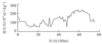
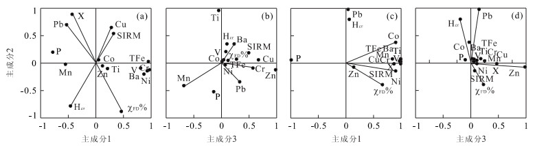
In order to probe the relationship between urbanization processes and the extent of water contamination, measurements were taken the magnetic susceptibility (χ) of 114 samples, and of the frequency-dependent susceptibility and magnetic hysteresis parameters and heavy metal of representative samples from sediments of Guozheng Lake and Tanglin Lake, Wuhan, Hubei Province.Resultsshow that in Guozheng Lake no principal component predominates and the correlation between susceptibility and heavy metal content is low. However, in Tanglin Lake, a principal component originating from industry predominates. Fe (total iron), Co, V, Mn, Ti, Ba, Cr, Ni and Cu are highly correlated with saturation (Ms), isothermal remanent magnetization (SIRM) and χ and the correlation coefficients are generally higher than 0.87. For sediments of both lakes, the correlation of SIRM with contents of heavy metals is higher than that of χ. So, saturation isothermal remanent magnetization (SIRM) can be considered as a proxy of the extent of heavy metal pollution.
In order to probe the relationship between urbanization processes and the extent of water contamination, measurements were taken the magnetic susceptibility (χ) of 114 samples, and of the frequency-dependent susceptibility and magnetic hysteresis parameters and heavy metal of representative samples from sediments of Guozheng Lake and Tanglin Lake, Wuhan, Hubei Province.Resultsshow that in Guozheng Lake no principal component predominates and the correlation between susceptibility and heavy metal content is low. However, in Tanglin Lake, a principal component originating from industry predominates. Fe (total iron), Co, V, Mn, Ti, Ba, Cr, Ni and Cu are highly correlated with saturation (Ms), isothermal remanent magnetization (SIRM) and χ and the correlation coefficients are generally higher than 0.87. For sediments of both lakes, the correlation of SIRM with contents of heavy metals is higher than that of χ. So, saturation isothermal remanent magnetization (SIRM) can be considered as a proxy of the extent of heavy metal pollution.


2006, 31(2): 273-278.
Abstract:
Aniline can enter the environment from many industries, and has been detected in surface water including river water. For many cities in north China such as Xi'an, Lanzhou and Harbin, the drinking water is produced from groundwater recharged by river water through riverbank filtration (RBF). Aniline is a refractory organic pollutant and harmful to humans. So its degradation and mechanism have received much attention. In this paper, soil columns containing sediment and aquifer media were collected from the Weihe riverbed and its bank, and were used to research the characteristics of aniline degradation in the riverbank filtration process under denitrification conditions. The results indicate that all aniline could be degraded by habituated indigenous microorganisms, and even mostly mineralized under denitrification conditions, but the degradation had a long lag period. A minority of aniline degradation must involve deamination, while the majority undergoes covalent binding with humic substances to form complexes. The complexes are degraded easily and even mineralized. During the degradation, no intermediates were harmful to denitrifiers. Therefore, under denitrification conditions, aniline has the potential to biodegrade in RBF and the potential lasts for long time, and this has not been monitored in the groundwater along the polluted river. During the 153 d testing process, the nitrate-nitrogen concentration was about 23.0 mg/L, and the aniline concentration was 40, 80 and 400 mg/L at 0-74 d, 75-105 d and 106-153 d respectively in infiltrating water. Indigenous microorganisms pass a lag period of 37 d, and grow on aniline as the source of carbon in the RBF under denitrification conditions. Aniline concentration in leachate is lower than the detected limits, so its removal rate was 100%. TOC removal rates were 97.99%, 91.39% and 75.30% for 40, 80 and 400 mg/L aniline concentrations respectively, based on TOC monitored infiltrating water and leachate.
Aniline can enter the environment from many industries, and has been detected in surface water including river water. For many cities in north China such as Xi'an, Lanzhou and Harbin, the drinking water is produced from groundwater recharged by river water through riverbank filtration (RBF). Aniline is a refractory organic pollutant and harmful to humans. So its degradation and mechanism have received much attention. In this paper, soil columns containing sediment and aquifer media were collected from the Weihe riverbed and its bank, and were used to research the characteristics of aniline degradation in the riverbank filtration process under denitrification conditions. The results indicate that all aniline could be degraded by habituated indigenous microorganisms, and even mostly mineralized under denitrification conditions, but the degradation had a long lag period. A minority of aniline degradation must involve deamination, while the majority undergoes covalent binding with humic substances to form complexes. The complexes are degraded easily and even mineralized. During the degradation, no intermediates were harmful to denitrifiers. Therefore, under denitrification conditions, aniline has the potential to biodegrade in RBF and the potential lasts for long time, and this has not been monitored in the groundwater along the polluted river. During the 153 d testing process, the nitrate-nitrogen concentration was about 23.0 mg/L, and the aniline concentration was 40, 80 and 400 mg/L at 0-74 d, 75-105 d and 106-153 d respectively in infiltrating water. Indigenous microorganisms pass a lag period of 37 d, and grow on aniline as the source of carbon in the RBF under denitrification conditions. Aniline concentration in leachate is lower than the detected limits, so its removal rate was 100%. TOC removal rates were 97.99%, 91.39% and 75.30% for 40, 80 and 400 mg/L aniline concentrations respectively, based on TOC monitored infiltrating water and leachate.


2006, 31(2): 279-284.
Abstract:
Reliable hydrological parameters of the rock and soil in a landslide are difficult to obtain using traditional investigative and testing methodology. This affects the quality of landslide modelling and evaluation. Based on the NMR (nuclear magnetism resonance) method of water seeking combined with some other investigation methods, a 3D landslide model was established. The method for studying the landslide stability in the Three Gorges was presented. The Zhaoshuling landslide in the Three Gorges Reservoir area was chosen to determine the accuracy of the 3D modelling. The hydrological parameters of the rock and soil were obtained by NMR and from a borehole. Two aquifers were determined: the upper one is an unconfined aquifer; and two sliding zones were found. The result from NMR analysis was identical with the data obtained from the borehole. This result could supply a reliable basis for landslide modelling which conforms to actual landslide conditions. Using the FEM program to consider the interaction between seepage and stress and ANSYS, the stability of the landslide was simulated with a water level under 145 m, at 175 m and from 175 m falling to 145 m. The results show that the landslide is still in a stable state at a water level of 145 m and 175 m. The unstable area in the front region of the landslide enlarges as the water level rises. When the water level falls from 175 m to 145 m, the landslide is in a state of limited equilibrium and local deformation and damage on the posterior border of the landslide is likely to occur.
Reliable hydrological parameters of the rock and soil in a landslide are difficult to obtain using traditional investigative and testing methodology. This affects the quality of landslide modelling and evaluation. Based on the NMR (nuclear magnetism resonance) method of water seeking combined with some other investigation methods, a 3D landslide model was established. The method for studying the landslide stability in the Three Gorges was presented. The Zhaoshuling landslide in the Three Gorges Reservoir area was chosen to determine the accuracy of the 3D modelling. The hydrological parameters of the rock and soil were obtained by NMR and from a borehole. Two aquifers were determined: the upper one is an unconfined aquifer; and two sliding zones were found. The result from NMR analysis was identical with the data obtained from the borehole. This result could supply a reliable basis for landslide modelling which conforms to actual landslide conditions. Using the FEM program to consider the interaction between seepage and stress and ANSYS, the stability of the landslide was simulated with a water level under 145 m, at 175 m and from 175 m falling to 145 m. The results show that the landslide is still in a stable state at a water level of 145 m and 175 m. The unstable area in the front region of the landslide enlarges as the water level rises. When the water level falls from 175 m to 145 m, the landslide is in a state of limited equilibrium and local deformation and damage on the posterior border of the landslide is likely to occur.


