


2006 Vol. 31, No. 6
Display Method:
2006, 31(6): 747-753.
 PDF 528KB
Abstract:
The earth'sorbital geometry configurates eccentricity, obliquity and precession, which control the seasonal and latitudinal distribution of the insolation on the earth's surface. In the periodic variations of the insolation, the precession cycles of 23 ka and 19 ka are significant at any latitude, and the obliquity cycle of 41 ka is evident only at high and middle latitudes, whereas the eccentricity cycles of 413 ka and 100 ka are nearly faint at any latitude. The traditional orbital theory emphasizes the insolation at high northern latitudes which controls global ice volume and climate change and probably transfers its periodicity to the linear climate system. However, the periodicity of the climatic proxies from the tropics is not identical to that of the insolation. Both the insolation and the tropical process perform strong precession and less strong obliquity cycles, highlighting the dominant control of the precession modulated insolation on the tropical climatic changes. Nevertheless, the tropical process especially the monsoon system commonly performs strong eccentricity cycles of 100 ka and 413 ka, as well as significant semi-precession cycles around 10 ka, which are nearly absent in the insolation. These features indicate that the non-linear tropical climatic process doesn't simply respond to the insolation change, nor is completely controlled by the high northern latitudes, but possesses feature of its own.
The earth'sorbital geometry configurates eccentricity, obliquity and precession, which control the seasonal and latitudinal distribution of the insolation on the earth's surface. In the periodic variations of the insolation, the precession cycles of 23 ka and 19 ka are significant at any latitude, and the obliquity cycle of 41 ka is evident only at high and middle latitudes, whereas the eccentricity cycles of 413 ka and 100 ka are nearly faint at any latitude. The traditional orbital theory emphasizes the insolation at high northern latitudes which controls global ice volume and climate change and probably transfers its periodicity to the linear climate system. However, the periodicity of the climatic proxies from the tropics is not identical to that of the insolation. Both the insolation and the tropical process perform strong precession and less strong obliquity cycles, highlighting the dominant control of the precession modulated insolation on the tropical climatic changes. Nevertheless, the tropical process especially the monsoon system commonly performs strong eccentricity cycles of 100 ka and 413 ka, as well as significant semi-precession cycles around 10 ka, which are nearly absent in the insolation. These features indicate that the non-linear tropical climatic process doesn't simply respond to the insolation change, nor is completely controlled by the high northern latitudes, but possesses feature of its own.


2006, 31(6): 754-764.
Abstract:
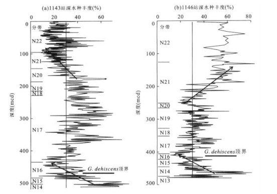
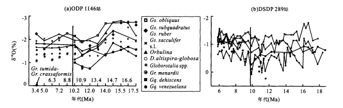
The disappearance at ~10 Ma of the deep dwelling planktonic foraminifer Globoquadrina dehiscens from the western Pacific including the South China Sea was about 3 Ma earlier than its final extinction elsewhere. Accompanying this event at ~10 Ma was a series of faunal turnover characterized by increase in mixed layer, warm-water species and decrease to a minimum in deepwater species. Paleobiological and isotopic evidences indicate sea surface warming and a deepened local thermocline that we interpret as related to the development of an early western Pacific warm pool. The stepwise decline of G. dehiscens and other deep dwelling species from the NW and SW Pacific suggests more intensive warm water pileup than equatorial localities where surface bypass flow through the narrowing Indonesia seaway appears to remain efficient during the Late Miocene. Planktonic 18O values from the South China Sea consistently lighter than the tropical western Pacific during the Miocene also suggest, similar to today, more variable hydrologic conditions along the periphery than in the core of the warm pool. Stronger hydrologic variability affected mainly by monsoons and increased thermal gradient along the western margin of the Late Miocene warm pool may have contributed to the decline of deep dwelling planktonic species including the early extinction of G. dehiscens from the South China Sea region.
The disappearance at ~10 Ma of the deep dwelling planktonic foraminifer Globoquadrina dehiscens from the western Pacific including the South China Sea was about 3 Ma earlier than its final extinction elsewhere. Accompanying this event at ~10 Ma was a series of faunal turnover characterized by increase in mixed layer, warm-water species and decrease to a minimum in deepwater species. Paleobiological and isotopic evidences indicate sea surface warming and a deepened local thermocline that we interpret as related to the development of an early western Pacific warm pool. The stepwise decline of G. dehiscens and other deep dwelling species from the NW and SW Pacific suggests more intensive warm water pileup than equatorial localities where surface bypass flow through the narrowing Indonesia seaway appears to remain efficient during the Late Miocene. Planktonic 18O values from the South China Sea consistently lighter than the tropical western Pacific during the Miocene also suggest, similar to today, more variable hydrologic conditions along the periphery than in the core of the warm pool. Stronger hydrologic variability affected mainly by monsoons and increased thermal gradient along the western margin of the Late Miocene warm pool may have contributed to the decline of deep dwelling planktonic species including the early extinction of G. dehiscens from the South China Sea region.


2006, 31(6): 765-772.
Abstract:
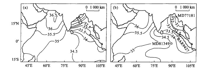
The climate was obviously instable in the last glacial cycle, especially in the Marine Oxygen Isotope Stage 3. The South Asian monsoon activities conflict with the glaciation and interglaciation rule. The paleo ceanographic study of the core BAR9427 from the south of the Andaman Sea, the Great Strait at the northwest terminal of the Sumatra Island in the northeast Indian Ocean, and its comparison with that of the nearby cores MD77181 and MD81349 in the Bay of Bengal, reach the following conclusions: the northeastern monsoon was strong in intensity with the active upwelling and the relatively high paleoproductivity over the studied area in the MIS 2 of the last glaciation. Meanwhile, the sea surface salinity increased due to the strong evaporation near the shore region. The southwestern monsoon was strong over the studied area in the early and late MIS 3. The easterly southwestern monsoon current increased the salinity in the middle of the Bay of Bengal. However, the salinity decreased greatly in the north of the Bay of Bengal because of both the monsoon rain and the influx of a mass of fresh water. In addition, the salinity was lower in August than in February. The southwestern monsoon activities follow the 23 ka precession cycle, a phenomenon also discovered in the Tibetan plateau, the loess and desert fields of China, and the Arabian Sea.
The climate was obviously instable in the last glacial cycle, especially in the Marine Oxygen Isotope Stage 3. The South Asian monsoon activities conflict with the glaciation and interglaciation rule. The paleo ceanographic study of the core BAR9427 from the south of the Andaman Sea, the Great Strait at the northwest terminal of the Sumatra Island in the northeast Indian Ocean, and its comparison with that of the nearby cores MD77181 and MD81349 in the Bay of Bengal, reach the following conclusions: the northeastern monsoon was strong in intensity with the active upwelling and the relatively high paleoproductivity over the studied area in the MIS 2 of the last glaciation. Meanwhile, the sea surface salinity increased due to the strong evaporation near the shore region. The southwestern monsoon was strong over the studied area in the early and late MIS 3. The easterly southwestern monsoon current increased the salinity in the middle of the Bay of Bengal. However, the salinity decreased greatly in the north of the Bay of Bengal because of both the monsoon rain and the influx of a mass of fresh water. In addition, the salinity was lower in August than in February. The southwestern monsoon activities follow the 23 ka precession cycle, a phenomenon also discovered in the Tibetan plateau, the loess and desert fields of China, and the Arabian Sea.


2006, 31(6): 773-779.
Abstract:
The Donggou Section located in the east of Nihewan basin contains a suite of strata consisted mainly of lacustrine sediments approximate to 100 m thick. Both grain size distribution and magnetic susceptibility are measured in successive samples collected from this section. A preliminary time scale can be derived, based on the comparison between records of magnetic susceptibility, from the geomagnetic polarity reversals determined by previous studies. In this study, the grain (20-50 μm) content record of Donggou Section can be correlated to the ETP curve. The low value of the former is compared with the high value of the latter. This negative correlation implies that the dust inputs into sediments in the Nihewan basin decreases while the solar radiation on the north hemisphere increases. This scenario is compatible with the known evolution of the aeolian activity in North China. Therefore, the grain (20-50 μm) content is a reliable proxy indicator of the paleoclimate change. Orbital tuning method is performed and a time scale of high resolution is obtained for the strata older than > 780 ka since the sedimentation rate here is relatively high. The 20 ka and 41 ka periodic components filtered from the obtained grain (20-50 μm) content time series are consistent with the theoretic cycles of the precession and the tilt, respectively, indicating that the grain (20-50 μm) content record of Donggou Section can be used as the climatic curve for orbital tuning.
The Donggou Section located in the east of Nihewan basin contains a suite of strata consisted mainly of lacustrine sediments approximate to 100 m thick. Both grain size distribution and magnetic susceptibility are measured in successive samples collected from this section. A preliminary time scale can be derived, based on the comparison between records of magnetic susceptibility, from the geomagnetic polarity reversals determined by previous studies. In this study, the grain (20-50 μm) content record of Donggou Section can be correlated to the ETP curve. The low value of the former is compared with the high value of the latter. This negative correlation implies that the dust inputs into sediments in the Nihewan basin decreases while the solar radiation on the north hemisphere increases. This scenario is compatible with the known evolution of the aeolian activity in North China. Therefore, the grain (20-50 μm) content is a reliable proxy indicator of the paleoclimate change. Orbital tuning method is performed and a time scale of high resolution is obtained for the strata older than > 780 ka since the sedimentation rate here is relatively high. The 20 ka and 41 ka periodic components filtered from the obtained grain (20-50 μm) content time series are consistent with the theoretic cycles of the precession and the tilt, respectively, indicating that the grain (20-50 μm) content record of Donggou Section can be used as the climatic curve for orbital tuning.


2006, 31(6): 780-786.
Abstract:
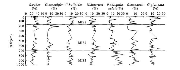
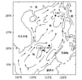
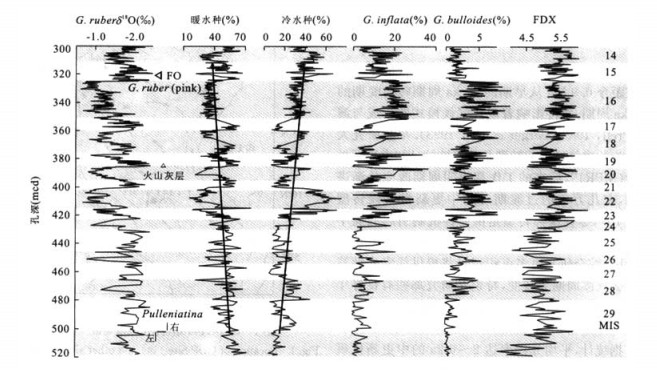
Planktonic foraminifera results from ODP Site 1144 in the northern South China Sea indicate that the Mid-Pleistocene climate transition is characterized by high-frequency changes on the millennial scale. In pace with glacial-interglacial cycles after the dominant glacial cyclicity shifted from 41 ka to 100 ka over the ~0.9 Ma, sudden increases in the abundance of cool-water planktonic foraminifera species became more evident. The SST variations estimated from transfer function show large decreases of up to 10 ℃ during the four major glacial periods of MIS22, 20, 18 and 16 between 0.9-0.6 Ma. Cooler conditions in glacial times also caused the thermocline depth to shoal in steps to a minimum of about 65 m at MIS20. Therefore, during the Mid-Pleistocene climate transition, the upper ocean water environment in the nouthern South China Sea was marked by δ18O values heavier than the last glacial maximum, a shoaled thermocline, and significant decrease to almost complete absence of several deep-water planktonic foraminiferal species, amplifying the paleoclimatic signals of SST contrasts between the northern and southern South China Sea and a strengthened winter monsoon on the millennial scale. Together with the E-W equatorial Pacific record, the N-S contrasts in the South China Sea demonstrate the significance of low latitude process in climate change.
Planktonic foraminifera results from ODP Site 1144 in the northern South China Sea indicate that the Mid-Pleistocene climate transition is characterized by high-frequency changes on the millennial scale. In pace with glacial-interglacial cycles after the dominant glacial cyclicity shifted from 41 ka to 100 ka over the ~0.9 Ma, sudden increases in the abundance of cool-water planktonic foraminifera species became more evident. The SST variations estimated from transfer function show large decreases of up to 10 ℃ during the four major glacial periods of MIS22, 20, 18 and 16 between 0.9-0.6 Ma. Cooler conditions in glacial times also caused the thermocline depth to shoal in steps to a minimum of about 65 m at MIS20. Therefore, during the Mid-Pleistocene climate transition, the upper ocean water environment in the nouthern South China Sea was marked by δ18O values heavier than the last glacial maximum, a shoaled thermocline, and significant decrease to almost complete absence of several deep-water planktonic foraminiferal species, amplifying the paleoclimatic signals of SST contrasts between the northern and southern South China Sea and a strengthened winter monsoon on the millennial scale. Together with the E-W equatorial Pacific record, the N-S contrasts in the South China Sea demonstrate the significance of low latitude process in climate change.


2006, 31(6): 787-797.
Abstract:
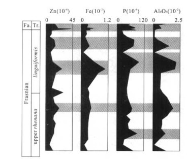
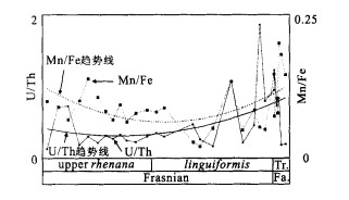
Geochemical data from the Yangdi Section of Guilin, Guangxi, showed an oxygen-rich to dysaerobic environment with the vibrating rise in sea-level in the Late Frasnian Stage, Devonian. At the same time, δ13Ccarb and δ13Ckerogen increased from +0.43 (‰V-PDB) to +3.54 (‰V-PDB), from -29.38 (‰V-PDB) to -24.14 (‰V-PDB), respectively, which could be related with the data from Europe, North America and Australia. These positive fluctuations were caused by the rapid increase in the so-called green algae and cyanobacteria (mostly < 0.1 mm). These bacteria and algae, as was observed through microscope, did not seem to have been influenced by the mass extinction event of Late Frasnian, but grew more rapidly. Correspondingly, the research into nutritious salt P and algae growth-stimulating elements such as Fe and Zn revealed several blooms of geomicrobes in the Frasnian. In particular, the land supply of these elements indicated that a large-scale growth of the terrigenous plants in the Late Devonian stimulated the prevalence of biochemical weathering, leading to the conclusion that the increase in nutritious elements imported from the surface runoff to the continental shelf changed the ocean chemical environment. Since these nutritious elements are closely associated with land supply, it may be true that the shallow sea eutrophication caused by land nutrient influx may have destroyed the surface-water ecosystem.
Geochemical data from the Yangdi Section of Guilin, Guangxi, showed an oxygen-rich to dysaerobic environment with the vibrating rise in sea-level in the Late Frasnian Stage, Devonian. At the same time, δ13Ccarb and δ13Ckerogen increased from +0.43 (‰V-PDB) to +3.54 (‰V-PDB), from -29.38 (‰V-PDB) to -24.14 (‰V-PDB), respectively, which could be related with the data from Europe, North America and Australia. These positive fluctuations were caused by the rapid increase in the so-called green algae and cyanobacteria (mostly < 0.1 mm). These bacteria and algae, as was observed through microscope, did not seem to have been influenced by the mass extinction event of Late Frasnian, but grew more rapidly. Correspondingly, the research into nutritious salt P and algae growth-stimulating elements such as Fe and Zn revealed several blooms of geomicrobes in the Frasnian. In particular, the land supply of these elements indicated that a large-scale growth of the terrigenous plants in the Late Devonian stimulated the prevalence of biochemical weathering, leading to the conclusion that the increase in nutritious elements imported from the surface runoff to the continental shelf changed the ocean chemical environment. Since these nutritious elements are closely associated with land supply, it may be true that the shallow sea eutrophication caused by land nutrient influx may have destroyed the surface-water ecosystem.


2006, 31(6): 798-806.
Abstract:
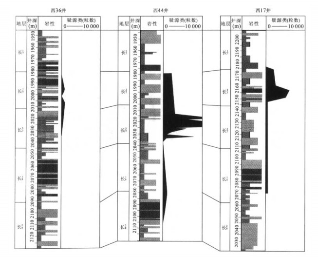
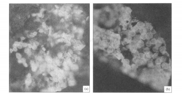
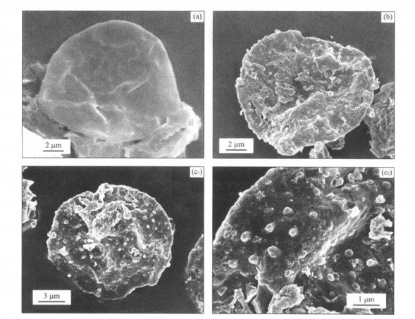
In this paper, the microfossil assemblage from drilling core samples of Xifeng oilfield is discussed with palynologic analystic method, to clarify terrestrial sediment environment of Yanchang Formation in Ordos basin during the Middle and Late Triassic. The research shows abundant acritarchs in the main oil-source rocks, namely in Chang 7 Section of Yanchang Formation. All these acritarchs, highly abundant in fossils, but monotone in species, are dominated absolutely by Leiophaerids acritarchs Leiosphaeridia, often associated with acanthomorphic acritarchs Micrhystridium. The contrast in the ecological distribution and assemblage between contemporaneous acritarchs, especially acanthomorphic acritarchs, illustrates that the sedimentary surroundings were fresh lacustrine. These acritarchs, not only monotone in species but also conspicuous in echinulate process, suggest that some acanthomorphic marine acritarchs survived long-time evolution in fresh water. The sedimentary environment of Chang 7 Section, the main source rock in the area, turned into the climax of lake transgression, indicating the supply of the large-scale lake water body from rivers instead of from the rise in sea level. These evidences prove that the Early and Middle Triassic paralic and lacustrine features had already been inactive in the Middle and Late Triassic Ordos basin.
In this paper, the microfossil assemblage from drilling core samples of Xifeng oilfield is discussed with palynologic analystic method, to clarify terrestrial sediment environment of Yanchang Formation in Ordos basin during the Middle and Late Triassic. The research shows abundant acritarchs in the main oil-source rocks, namely in Chang 7 Section of Yanchang Formation. All these acritarchs, highly abundant in fossils, but monotone in species, are dominated absolutely by Leiophaerids acritarchs Leiosphaeridia, often associated with acanthomorphic acritarchs Micrhystridium. The contrast in the ecological distribution and assemblage between contemporaneous acritarchs, especially acanthomorphic acritarchs, illustrates that the sedimentary surroundings were fresh lacustrine. These acritarchs, not only monotone in species but also conspicuous in echinulate process, suggest that some acanthomorphic marine acritarchs survived long-time evolution in fresh water. The sedimentary environment of Chang 7 Section, the main source rock in the area, turned into the climax of lake transgression, indicating the supply of the large-scale lake water body from rivers instead of from the rise in sea level. These evidences prove that the Early and Middle Triassic paralic and lacustrine features had already been inactive in the Middle and Late Triassic Ordos basin.
2006, 31(6): 807-816.
Abstract:
Petrologicos-geochemical data reveals the compositional features of Mesozoic volcanic rocks in West Liaoning: (1) Relatively high values of Mg# and higher contents of Cr and Ni; (2) Most of volcanic magmas are derived from enriched lithospheric mantle hybridized by crust materials; (3) Considerable volcanic rocks have relatively high εNd(t)values. Chronologic researches on the Mesozoic (230-65 Ma) volcanic rocks in West Liaoning and adjacent areas indicate that the volcanic activities were periodic with an average period of 20-30 Ma, and that the peak ages of the volcanic activities were determined at 230 Ma, 190 Ma, 160 Ma, 130-120 Ma, 110-100 Ma, and 80 Ma, respectively. Temporally, the εNd(t)values of the volcanic rocks also show similar periodic variation responsible for the ages. Specifically, the Mesozoic-Cenozoic volcanic rocks are distributed in a ring-like shape with their ages ranging from old to young in an outward order from the center. These evidences lead to the conclusion that the Late Mesozoic volcanic activities in the study area are related to pulsative upwelling diapirs of asthenosphere, for which a natural passage is provided by the specific tectonic background confined by large-scale lithospheric faults in the study area.
Petrologicos-geochemical data reveals the compositional features of Mesozoic volcanic rocks in West Liaoning: (1) Relatively high values of Mg# and higher contents of Cr and Ni; (2) Most of volcanic magmas are derived from enriched lithospheric mantle hybridized by crust materials; (3) Considerable volcanic rocks have relatively high εNd(t)values. Chronologic researches on the Mesozoic (230-65 Ma) volcanic rocks in West Liaoning and adjacent areas indicate that the volcanic activities were periodic with an average period of 20-30 Ma, and that the peak ages of the volcanic activities were determined at 230 Ma, 190 Ma, 160 Ma, 130-120 Ma, 110-100 Ma, and 80 Ma, respectively. Temporally, the εNd(t)values of the volcanic rocks also show similar periodic variation responsible for the ages. Specifically, the Mesozoic-Cenozoic volcanic rocks are distributed in a ring-like shape with their ages ranging from old to young in an outward order from the center. These evidences lead to the conclusion that the Late Mesozoic volcanic activities in the study area are related to pulsative upwelling diapirs of asthenosphere, for which a natural passage is provided by the specific tectonic background confined by large-scale lithospheric faults in the study area.


2006, 31(6): 817-822.
Abstract:
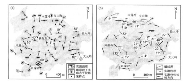
Three layers are present in the middle and upper crusts in the northern border of Sulu orogenic belt, as revealed by the S-N-strike reflecting seismic profiles that cross the Zhucheng sag. These three layers are the uppermost sedimentary cover of Jiaolai basin, the Sulu sphenoid terrane in the middle layer and the Jiaobei terrane representing North China plate at the bottom. The fringe of Zhucheng sag and the interior fault are characterized by the syndeposit normal fault. A group of imbricated reverse thrust facing upward to the north has developed in Sulu sphenoid terrane, but the Jiaobei terrane has the trend of subducting to the south. As a result, a collision mechanism is perhaps present between continents where North China plate and Yangtze plate subducted to each other below the Sulu terrene which has the same flower-shape orogenic structure as that of Dabie terrane.
Three layers are present in the middle and upper crusts in the northern border of Sulu orogenic belt, as revealed by the S-N-strike reflecting seismic profiles that cross the Zhucheng sag. These three layers are the uppermost sedimentary cover of Jiaolai basin, the Sulu sphenoid terrane in the middle layer and the Jiaobei terrane representing North China plate at the bottom. The fringe of Zhucheng sag and the interior fault are characterized by the syndeposit normal fault. A group of imbricated reverse thrust facing upward to the north has developed in Sulu sphenoid terrane, but the Jiaobei terrane has the trend of subducting to the south. As a result, a collision mechanism is perhaps present between continents where North China plate and Yangtze plate subducted to each other below the Sulu terrene which has the same flower-shape orogenic structure as that of Dabie terrane.


2006, 31(6): 823-829.
Abstract:
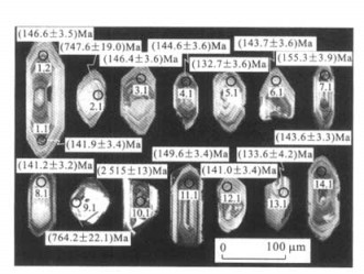
Geodynamic settings play an important role in controlling generation, ascent and final emplacement of magma. Mesozoic intermediate-acid intrusive rocks are closely related with large scale mineralization in the Tongling metallogenic cluster area. The Fenghuangshan pluton, which consists of granodiorite and quartz monzodiorite, is the main part of the Fenghuangshan ore field. Zircon SHRIMP 206Pb/238U dating shows that the Fenghuangshan pluton formed at (144.2±2.3) Ma, belonging to the Late Jurassic era, which is in accordance with most of metallogenic plutons of the Tongling metallogenic cluster area. The contact deformation shows that the Fenghuangshan pluton was controlled by a regional sinistral shear stress field. The internal deformation indicates that the pluton experienced sinistral spiral ascent and final ballooning emplacement. The age and structural deformation imply that the Late Jurassic pluton related to mineralization may correlate with sinistral shear stress field induced by the northward oblique subduction of the paleo-Pacific plate.
Geodynamic settings play an important role in controlling generation, ascent and final emplacement of magma. Mesozoic intermediate-acid intrusive rocks are closely related with large scale mineralization in the Tongling metallogenic cluster area. The Fenghuangshan pluton, which consists of granodiorite and quartz monzodiorite, is the main part of the Fenghuangshan ore field. Zircon SHRIMP 206Pb/238U dating shows that the Fenghuangshan pluton formed at (144.2±2.3) Ma, belonging to the Late Jurassic era, which is in accordance with most of metallogenic plutons of the Tongling metallogenic cluster area. The contact deformation shows that the Fenghuangshan pluton was controlled by a regional sinistral shear stress field. The internal deformation indicates that the pluton experienced sinistral spiral ascent and final ballooning emplacement. The age and structural deformation imply that the Late Jurassic pluton related to mineralization may correlate with sinistral shear stress field induced by the northward oblique subduction of the paleo-Pacific plate.


2006, 31(6): 830-838.
Abstract:
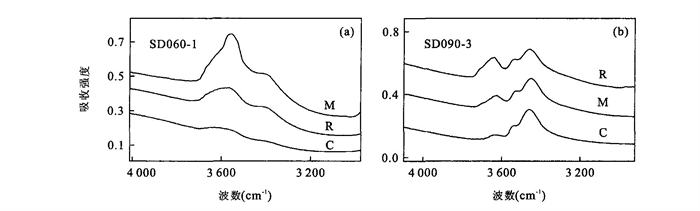
Along with the processes of continent crust subduction, the nominally anhydrous minerals (NAMs) in UHP rocks can transport some surface water into the deep upper mantle. Such water stored in the deep upper mantle plays an important role in the dynamics of the earth's interior. Omphacite and garnet in UHP eclogites from the Chinese Continental Scientific Drilling (CCSD) main hole have been investigated by Fourier transform infrared spectroscopy (FTIR) in this work. The result demonstrates that all omphacite and garnet grains contain structural water from 68μg/g to 529μg/g and from 20μg/g to 875μg/g respectively; the contents of structural water in the whole rock of eclogite range from 150μg/g to 300μg/g. There are two types of water distribution characteristics within single garnet and omphacite grains, one is homogeneous and the other is inhomogeneous. The inhomogeneous phenomena show that the water contents increase from the core, the middle to the rim within the grains, and both the core and the rim contents are low but the middle is high. Electron probe microanalysis shows that the inhomogeneous distribution of water content has no direct relation with the chemical composition of the mineral. Inhomogeneous dislocation is likely to result in the inhomogeneous distribution of structural water in single grain NAMs.
Along with the processes of continent crust subduction, the nominally anhydrous minerals (NAMs) in UHP rocks can transport some surface water into the deep upper mantle. Such water stored in the deep upper mantle plays an important role in the dynamics of the earth's interior. Omphacite and garnet in UHP eclogites from the Chinese Continental Scientific Drilling (CCSD) main hole have been investigated by Fourier transform infrared spectroscopy (FTIR) in this work. The result demonstrates that all omphacite and garnet grains contain structural water from 68μg/g to 529μg/g and from 20μg/g to 875μg/g respectively; the contents of structural water in the whole rock of eclogite range from 150μg/g to 300μg/g. There are two types of water distribution characteristics within single garnet and omphacite grains, one is homogeneous and the other is inhomogeneous. The inhomogeneous phenomena show that the water contents increase from the core, the middle to the rim within the grains, and both the core and the rim contents are low but the middle is high. Electron probe microanalysis shows that the inhomogeneous distribution of water content has no direct relation with the chemical composition of the mineral. Inhomogeneous dislocation is likely to result in the inhomogeneous distribution of structural water in single grain NAMs.

2006, 31(6): 839-845.
Abstract:
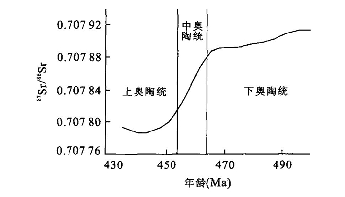
In this paper, ICP-MS analytic technology is employed to test the strontium and manganese contents of 109 samples collected from four wells in Tazhong area, Tarim basin. In addition, strontium isotope composition tests have also been conducted, with VG354 solid isotope mass spectrograph, on 25 samples from Zhong 1 and Zhong 4 wells. The analysis of strontium and manganese contents, the research into the characteristics of strontium isotope composition from Zhong 1 and Zhong 4 wells, the comparison between the results from strontium analysis of the global Ordovician marine carbonate and its evolution trend, and the combination of sedimentary facies characteristics of isolated wells in this area conclude the following five points: (1) The marine carbonate strontium isotope curve in the Tazhong area of Tarim basin is consistent with the global evolution trend generally descending with time, the direct reason of which is the evolution of paleogeographic environment. The Ordovician paleogeographic environment ranged from the restricted platform to the open platform and then to the shallow marine shelf in Tazhong area, Tarim basin. Dolomitization is another secondary reason, and the inversion of fluid with high manganese can lead to heavy strontium; (2) The 87Sr/86Sr ratios of the Upper Ordovician in Tazhong area characterized by an apparent mono-decline trend that goes with the time, similar to the global strontium isotope ratio, implies the starting point of the variation of the Upper Ordovician sea level, the overall trend of which is rising; (3) Compared with the global seawater strontium ratios, the 87Sr/86Sr ratio of the Lower Ordovician is much higher, and the 87Sr/86Sr ratio of the Lower Ordovician is often increasing, with its maximum value determined at 0.709 727. The dolomitization, the evaporation of the supratide, and the reflux of high manganese haline, closely associated with such an increasing ratio, can lead to the increase in the content of the strontium and the rise in the 87Sr/86Sr ratio; (4) The manganese content varies little, and is affected little by dolomitization; (5) Large variations occur in the strontium values of Ordovician carbonate in the Tazhong district. Apart from paleogeographic environment and petrography, other factors that can affect the values of strontium are the content of the terrestrial clastics and the diagenisis modification which may result in the further change in the strontium values.
In this paper, ICP-MS analytic technology is employed to test the strontium and manganese contents of 109 samples collected from four wells in Tazhong area, Tarim basin. In addition, strontium isotope composition tests have also been conducted, with VG354 solid isotope mass spectrograph, on 25 samples from Zhong 1 and Zhong 4 wells. The analysis of strontium and manganese contents, the research into the characteristics of strontium isotope composition from Zhong 1 and Zhong 4 wells, the comparison between the results from strontium analysis of the global Ordovician marine carbonate and its evolution trend, and the combination of sedimentary facies characteristics of isolated wells in this area conclude the following five points: (1) The marine carbonate strontium isotope curve in the Tazhong area of Tarim basin is consistent with the global evolution trend generally descending with time, the direct reason of which is the evolution of paleogeographic environment. The Ordovician paleogeographic environment ranged from the restricted platform to the open platform and then to the shallow marine shelf in Tazhong area, Tarim basin. Dolomitization is another secondary reason, and the inversion of fluid with high manganese can lead to heavy strontium; (2) The 87Sr/86Sr ratios of the Upper Ordovician in Tazhong area characterized by an apparent mono-decline trend that goes with the time, similar to the global strontium isotope ratio, implies the starting point of the variation of the Upper Ordovician sea level, the overall trend of which is rising; (3) Compared with the global seawater strontium ratios, the 87Sr/86Sr ratio of the Lower Ordovician is much higher, and the 87Sr/86Sr ratio of the Lower Ordovician is often increasing, with its maximum value determined at 0.709 727. The dolomitization, the evaporation of the supratide, and the reflux of high manganese haline, closely associated with such an increasing ratio, can lead to the increase in the content of the strontium and the rise in the 87Sr/86Sr ratio; (4) The manganese content varies little, and is affected little by dolomitization; (5) Large variations occur in the strontium values of Ordovician carbonate in the Tazhong district. Apart from paleogeographic environment and petrography, other factors that can affect the values of strontium are the content of the terrestrial clastics and the diagenisis modification which may result in the further change in the strontium values.


2006, 31(6): 846-850.
Abstract:
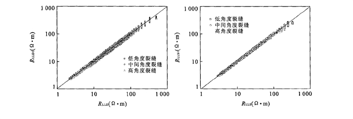
The estimation of fractures is a key to the evaluation of the fractured carbonate reservoirs. Many obstacles are present for the evaluation of this kind of reservoir because of its heterogeneously-distributed fractures and anisotropies. A three-dimensional numerical algorithm based on a macro-isotropic anisotropic model, a fast fracture-computing method, may simulate the responses of the dual-laterolog in fractured formation. Firstly, the apparent conductivity of dual-laterolog is linearly related to the porosity of fracture and to the conductivity of pore fluid. Secondly, the amplitude difference of the deep and shallow apparent resistivity logs was dependent mainly on the dip angle of the fracture. Thirdly, the response of dual laterolog of formation with dip angle fractures is approximately depicted as a function of bulk resistivity of rock, porosity of fracture and conductivity of fracture fluid, for the rapid computation of the fracture porosity. The research data show that the fracture parameters determined by the dual laterolog coincide well with the formation micro-image log.
The estimation of fractures is a key to the evaluation of the fractured carbonate reservoirs. Many obstacles are present for the evaluation of this kind of reservoir because of its heterogeneously-distributed fractures and anisotropies. A three-dimensional numerical algorithm based on a macro-isotropic anisotropic model, a fast fracture-computing method, may simulate the responses of the dual-laterolog in fractured formation. Firstly, the apparent conductivity of dual-laterolog is linearly related to the porosity of fracture and to the conductivity of pore fluid. Secondly, the amplitude difference of the deep and shallow apparent resistivity logs was dependent mainly on the dip angle of the fracture. Thirdly, the response of dual laterolog of formation with dip angle fractures is approximately depicted as a function of bulk resistivity of rock, porosity of fracture and conductivity of fracture fluid, for the rapid computation of the fracture porosity. The research data show that the fracture parameters determined by the dual laterolog coincide well with the formation micro-image log.


2006, 31(6): 851-856.
Abstract:
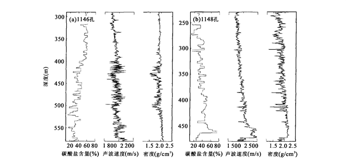
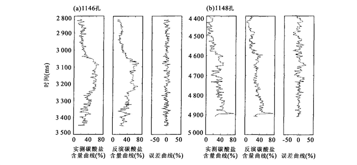
Based upon the relationship between carbonate content and stratal velocity and density, we attempted to apply the artificial neural network to the inversion of carbonate content summarized from the high-resolution seismic data limited by controlled well measurements. The method was applied to the slope area of the northern South China Sea near ODP Sites 1146 and 1148, with satisfactory results. The key to this method is the collection of several properties from seismic profiles across or near the wells. Then the progressive regression method was primarily applied to the determination of six seismic properties, most closely related to carbonate content variations, which are defined as average frequency, integrated absolute amplitude, dominating frequency, reflection time, derivative instantaneous amplitude, and instantaneous frequency. Finally, the stratal carbonate content is reversed. The reversal results thus obtained, with the errors of carbonate content mostly ranging within ±5% relative to those measured from sediment samples, show a relative accurate picture of carbonate-content distribution along the slope profile.
Based upon the relationship between carbonate content and stratal velocity and density, we attempted to apply the artificial neural network to the inversion of carbonate content summarized from the high-resolution seismic data limited by controlled well measurements. The method was applied to the slope area of the northern South China Sea near ODP Sites 1146 and 1148, with satisfactory results. The key to this method is the collection of several properties from seismic profiles across or near the wells. Then the progressive regression method was primarily applied to the determination of six seismic properties, most closely related to carbonate content variations, which are defined as average frequency, integrated absolute amplitude, dominating frequency, reflection time, derivative instantaneous amplitude, and instantaneous frequency. Finally, the stratal carbonate content is reversed. The reversal results thus obtained, with the errors of carbonate content mostly ranging within ±5% relative to those measured from sediment samples, show a relative accurate picture of carbonate-content distribution along the slope profile.


2006, 31(6): 857-860.
Abstract:
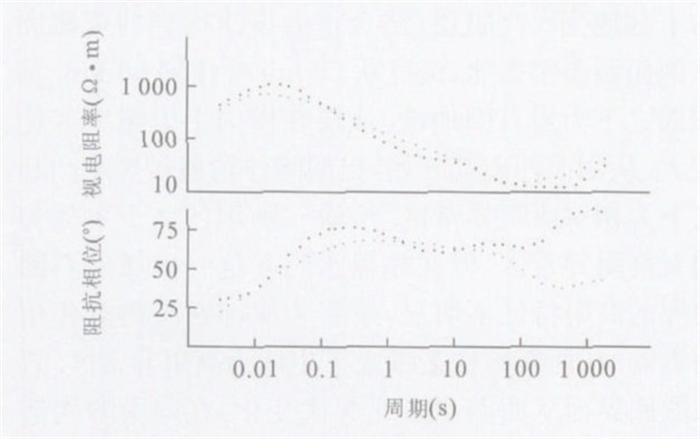
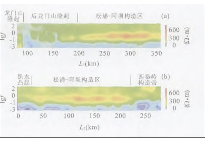
The magnetotelluric sounding (MT) surveying was recently conducted in the Songpan-Aba district in the northwest of Sichuan, a "delta" specific to the eastern part of the Tibetan plateau. The analysis of the two crossed MT inversion sections reveals a relatively stable block in the middle and deep structures of the Songpan-Aba district with conspicuous layers and few changes in electrical property. A low-resistivity layer about 10-20 km deep was found inside the crust. The electrical property of the deep layer (inside the mantle of the lithosphere) is classified as two types: the high-resistivity anomaly zone and the sub-high-resistivity anomaly zone with the low-resistivity layer inside the mantle. The corresponding lithosphere is about 120 km, so that the deep faults of the district contact their adjacent zones in all directions. The value of resistivity below the crust and upper mantle of the lithosphere is lower than that in its adjacent zones. The electrical property of the deep layer in this district is different from that in the uplifted Longmen Mountain, and also from that in the West Qinling structural zone characterized by both the high-resistivity basement and the thicker or thinner lithosphere.
The magnetotelluric sounding (MT) surveying was recently conducted in the Songpan-Aba district in the northwest of Sichuan, a "delta" specific to the eastern part of the Tibetan plateau. The analysis of the two crossed MT inversion sections reveals a relatively stable block in the middle and deep structures of the Songpan-Aba district with conspicuous layers and few changes in electrical property. A low-resistivity layer about 10-20 km deep was found inside the crust. The electrical property of the deep layer (inside the mantle of the lithosphere) is classified as two types: the high-resistivity anomaly zone and the sub-high-resistivity anomaly zone with the low-resistivity layer inside the mantle. The corresponding lithosphere is about 120 km, so that the deep faults of the district contact their adjacent zones in all directions. The value of resistivity below the crust and upper mantle of the lithosphere is lower than that in its adjacent zones. The electrical property of the deep layer in this district is different from that in the uplifted Longmen Mountain, and also from that in the West Qinling structural zone characterized by both the high-resistivity basement and the thicker or thinner lithosphere.


2006, 31(6): 861-866.
Abstract:
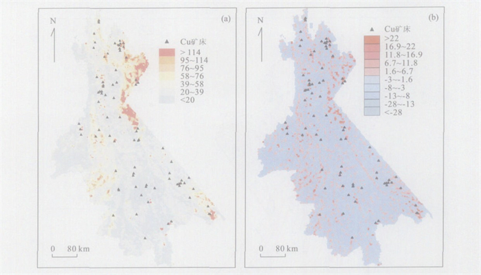
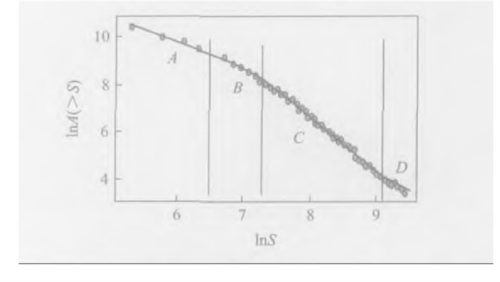
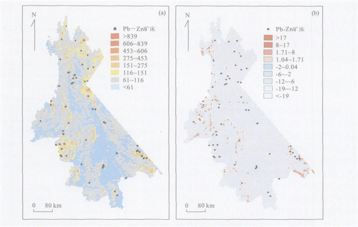
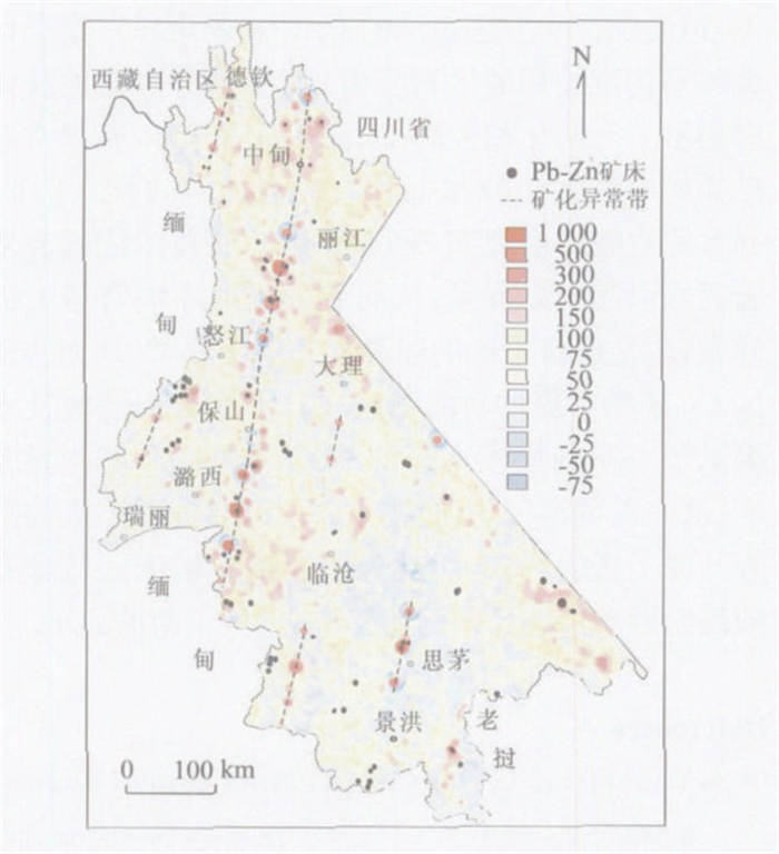
The southern section of "Sanjiang ore-forming zone" (the western Yunnan terrain), southwestern China, located at the joined belt between the Indian plate and Yangtze plate, is an important area of eastern Tethyan tectonic ore-forming domain. The polycyclic tectono-magmatic activities resulted both in the diversity of ore-forming geochemical background, and in the numerous base metal deposits and precious metal deposits, including a few such world-class deposits as the Jinding Pb-Zn deposit and the Laowangzhai Au deposit within the section. Such a complex geochemical background challenges us with the geostatistical extraction of geochemical anomalies for the mineralization purpose. For this, the multi- fractal filtering (S-A method) technique is introduced to isolate effectively the Cu and Zn anomalies related to mineralization in the complex multi-geochemical background. The following three research results are obtained in this study: (1) In the complicated geochemical background, the residual anomalies of Cu and Zn uncovered by Kriging are typical of the regional anomalies controlled by the regional linear fractural pattern; but the S-A method reveals the local anomalies of Cu and Zn associated with mineralization; (2) The separation of the Cu anomaly from its background demonstrates that the S-A method could effectively identify the high geochemical background of Cu from basalts and extract the Cu anomalies from multi-geochemical background, including weak and hidden Cu anomalies from their low background; (3) A few NNE-trending Zn mineralized and anomalous belts containing the super-large Jinding Pb-Zn deposit and a series of some other Pb-Zn deposits, that are absent at the Zn original data map, are clearly shown at the S-A anomalous map. This discovery presents us with not only new areas for prospecting Cu-Pb-Zn deposits but also new perspectives for the research into new ore-controlling factors, for the regional distribution of Pb-Zn deposits, which may include NNE-trending hidden fractures. All the research work is completed with the help of MORPAS 3.0.
The southern section of "Sanjiang ore-forming zone" (the western Yunnan terrain), southwestern China, located at the joined belt between the Indian plate and Yangtze plate, is an important area of eastern Tethyan tectonic ore-forming domain. The polycyclic tectono-magmatic activities resulted both in the diversity of ore-forming geochemical background, and in the numerous base metal deposits and precious metal deposits, including a few such world-class deposits as the Jinding Pb-Zn deposit and the Laowangzhai Au deposit within the section. Such a complex geochemical background challenges us with the geostatistical extraction of geochemical anomalies for the mineralization purpose. For this, the multi- fractal filtering (S-A method) technique is introduced to isolate effectively the Cu and Zn anomalies related to mineralization in the complex multi-geochemical background. The following three research results are obtained in this study: (1) In the complicated geochemical background, the residual anomalies of Cu and Zn uncovered by Kriging are typical of the regional anomalies controlled by the regional linear fractural pattern; but the S-A method reveals the local anomalies of Cu and Zn associated with mineralization; (2) The separation of the Cu anomaly from its background demonstrates that the S-A method could effectively identify the high geochemical background of Cu from basalts and extract the Cu anomalies from multi-geochemical background, including weak and hidden Cu anomalies from their low background; (3) A few NNE-trending Zn mineralized and anomalous belts containing the super-large Jinding Pb-Zn deposit and a series of some other Pb-Zn deposits, that are absent at the Zn original data map, are clearly shown at the S-A anomalous map. This discovery presents us with not only new areas for prospecting Cu-Pb-Zn deposits but also new perspectives for the research into new ore-controlling factors, for the regional distribution of Pb-Zn deposits, which may include NNE-trending hidden fractures. All the research work is completed with the help of MORPAS 3.0.


2006, 31(6): 867-872.
Abstract:
Resonant cavity perturbation method, widely used as an easy and fast method for determining dielectric properties of materials at microwave frequencies, is very sensitive to the measurement of the materials with low ε′ and tanδ values. However, it is not suitable to measure a majority of rocks and minerals whose ε′ and tanδ values are beyond the measurement range using the perturbation method. This paper proposes the polythene dilution method, a new perturbation-based method, to measure complex dielectric permittivity of dry rocks and minerals over 9 370 MHz. At first, the dry rocks and minerals are ground into powder, and then they are mixed in a given proportion with polythene powder, both with relatively low ε′ and tanδ and with stable dielectric property, and then hot-pressed into fine granular specimens. The perturbation method is used to measure the complex dielectric permittivity of the rock and plastic mixture. The dielectric property of the two-phase mixed system and its relation to either of the two phases can be obtained with Lichtenecker mixture formulae. Since the complex dielectric permittivity of the polythene is known, the complex dielectric permittivity of the rock samples can be calculated from that of the rock and mineral samples. At 9 370 MHz, as shown by the measurement results, the measurement of the same testing sample produced the same result with either of the perturbation method of rectangular or round resonant cavities, or of the transmission reflectometry, and provided us with the complex dielectric permittivity data measured from part of the dry rocks and minerals.
Resonant cavity perturbation method, widely used as an easy and fast method for determining dielectric properties of materials at microwave frequencies, is very sensitive to the measurement of the materials with low ε′ and tanδ values. However, it is not suitable to measure a majority of rocks and minerals whose ε′ and tanδ values are beyond the measurement range using the perturbation method. This paper proposes the polythene dilution method, a new perturbation-based method, to measure complex dielectric permittivity of dry rocks and minerals over 9 370 MHz. At first, the dry rocks and minerals are ground into powder, and then they are mixed in a given proportion with polythene powder, both with relatively low ε′ and tanδ and with stable dielectric property, and then hot-pressed into fine granular specimens. The perturbation method is used to measure the complex dielectric permittivity of the rock and plastic mixture. The dielectric property of the two-phase mixed system and its relation to either of the two phases can be obtained with Lichtenecker mixture formulae. Since the complex dielectric permittivity of the polythene is known, the complex dielectric permittivity of the rock samples can be calculated from that of the rock and mineral samples. At 9 370 MHz, as shown by the measurement results, the measurement of the same testing sample produced the same result with either of the perturbation method of rectangular or round resonant cavities, or of the transmission reflectometry, and provided us with the complex dielectric permittivity data measured from part of the dry rocks and minerals.
2006, 31(6): 873-878.
Abstract:
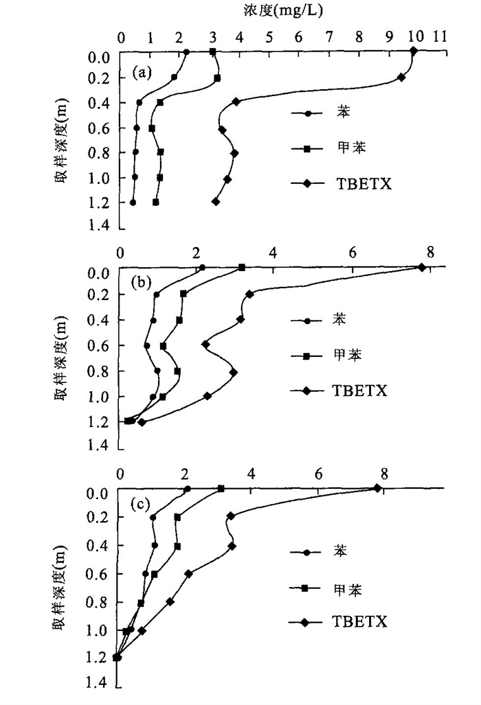
In the five-month indoor earth-column experiment, three representative kinds of natural sand are analyzed, and the refluxes of domestic sewage are used to simulate the contaminated river flow. This indoor experiment aims at both the simulation of the migration and transfer law of aromatic hydrocarbons in the surface water-underground water system in a long-term drainage river and that of the impacts of different aquiferous media and hydrodynamic conditions on the decontamination of aromatic hydrocarbons. Aromatic hydrocarbons in column decrease gradually with the flow direction, where the natural decontamination occurs at 0.4 m of the surface layer. Total decontamination ratios of benzene, toluene and total aromatic hydrocarbons (TBETX) in the coarse sand is 32.06%, 21.39% and 27.13%, respectively; in the first kind of the medium sand is 76.26%, 81.40% and 87.99%, respectively; in the second kind of the medium sand is 68.94%, 74.41% and 81.69%, respectively. All these results indicate that the hydrous medium in the riverbed is perfectly saturated in the early period of the contamination of the river, where the greater the size of the hydrous medium, the lower the decontamination rate of the aromatic hydrocarbons. In this case, the aromatic hydrocarbons migrate easily into the underground water system. As times went by, the silt seams in the riverbed became thicker and thicker till unsaturated flow moves into the sand. However, when the decontamination rate of aromatic hydrocarbons in the silt seams and hydrous medium system is greater than that in the saturated water flow, the aromatic hydrocarbons will not easily migrate into the corresponding underground water system.
In the five-month indoor earth-column experiment, three representative kinds of natural sand are analyzed, and the refluxes of domestic sewage are used to simulate the contaminated river flow. This indoor experiment aims at both the simulation of the migration and transfer law of aromatic hydrocarbons in the surface water-underground water system in a long-term drainage river and that of the impacts of different aquiferous media and hydrodynamic conditions on the decontamination of aromatic hydrocarbons. Aromatic hydrocarbons in column decrease gradually with the flow direction, where the natural decontamination occurs at 0.4 m of the surface layer. Total decontamination ratios of benzene, toluene and total aromatic hydrocarbons (TBETX) in the coarse sand is 32.06%, 21.39% and 27.13%, respectively; in the first kind of the medium sand is 76.26%, 81.40% and 87.99%, respectively; in the second kind of the medium sand is 68.94%, 74.41% and 81.69%, respectively. All these results indicate that the hydrous medium in the riverbed is perfectly saturated in the early period of the contamination of the river, where the greater the size of the hydrous medium, the lower the decontamination rate of the aromatic hydrocarbons. In this case, the aromatic hydrocarbons migrate easily into the underground water system. As times went by, the silt seams in the riverbed became thicker and thicker till unsaturated flow moves into the sand. However, when the decontamination rate of aromatic hydrocarbons in the silt seams and hydrous medium system is greater than that in the saturated water flow, the aromatic hydrocarbons will not easily migrate into the corresponding underground water system.

2006, 31(6): 879-884.
Abstract:
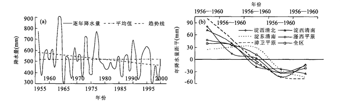
The research from 1986 to 2000 into the dynamic processes and interactions among annual precipitation, annual groundwater recharge from rainfall and annual pumpage for agriculture in Hebei plain to the south of Beijing and Tianjin, revealed the negative relationship between the increase or decrease in annual precipitation and the contemporaneous annual groundwater recharge from rainfall and the annual pumpage. In another word, when the annual precipitation decreases, the recharge decreases, but the pumpage increases. However, when the annual precipitation increases, the recharge increases to a relatively great extent, but the pumpage decreases. During the successive years of shortage or abundance of water, if the annual precipitation decreases (or increases) by 10 mm, the water quantity of the regional groundwater system decreases by 7.08 mm (or increases by 7.06 mm) and the corresponding water level falls (rises) by 5.2 cm to 8.7 cm. In the range of the annual precipitation variation from 10 to 320 mm, if the annual precipitation decreases (or increases) by 10%, the water quantity of the regional groundwater system decreases by 7.98% (or increases by 7.67%), the corresponding water level falls (rises) at the same rate. The effect of the precipitation variation both on the decrease in recharge and on the increase in pumpage in the dehumidification season is greater than that on the increase in recharge and on the decrease in pumpage in the increasingly raining season. Therefore, more attention should be paid to some measures that may soften the effect of the precipitation variation on the underground water system in the successive years of shortage of water, which may be of great significance to the stability and security in the underground water supply system in the north of China.
The research from 1986 to 2000 into the dynamic processes and interactions among annual precipitation, annual groundwater recharge from rainfall and annual pumpage for agriculture in Hebei plain to the south of Beijing and Tianjin, revealed the negative relationship between the increase or decrease in annual precipitation and the contemporaneous annual groundwater recharge from rainfall and the annual pumpage. In another word, when the annual precipitation decreases, the recharge decreases, but the pumpage increases. However, when the annual precipitation increases, the recharge increases to a relatively great extent, but the pumpage decreases. During the successive years of shortage or abundance of water, if the annual precipitation decreases (or increases) by 10 mm, the water quantity of the regional groundwater system decreases by 7.08 mm (or increases by 7.06 mm) and the corresponding water level falls (rises) by 5.2 cm to 8.7 cm. In the range of the annual precipitation variation from 10 to 320 mm, if the annual precipitation decreases (or increases) by 10%, the water quantity of the regional groundwater system decreases by 7.98% (or increases by 7.67%), the corresponding water level falls (rises) at the same rate. The effect of the precipitation variation both on the decrease in recharge and on the increase in pumpage in the dehumidification season is greater than that on the increase in recharge and on the decrease in pumpage in the increasingly raining season. Therefore, more attention should be paid to some measures that may soften the effect of the precipitation variation on the underground water system in the successive years of shortage of water, which may be of great significance to the stability and security in the underground water supply system in the north of China.


2006, 31(6): 885-890.
Abstract:
This paper takes the eastern and western mountain areas of Taiyuan basin, Shanxi Province as a case study. On the basis of groundwater system theory and geographic information system (GIS) technique, some quantitative or semiquantitative structural information was first extracted from lithofacies paleogeography, geology, tectonics and hydrogeology in the study area, including the isolines of the base of regional karst-water aquifers, the projective section of both the planes of a fault and the mapping of karst-water system. The distribution of karst aquifers, the stratum permeability, the boundary characteristics and the relationship between the internal and external system all serve the classification of the karst-water system as local zone of saturation, regional zone of saturation and zone of passage. The research results show that in the western mountain area, the subsystem of Lancun spring and that of Jinci spring belong to the same regional karst-water system, and the subsystem of Xiye spring is an independent karst-water system. The majority of eastern mountain area belongs to the subsystem of Niangziguan spring. The subsystem of the eastern mountain area closely related to the groundwater system in the Taiyuan basin has no direct relation with the subsytem of Lancun and Jinci springs. These scientific evidences can effectively be employed to simulate the groundwater system and to evaluate the karst-water resources in the Taiyuan basin. Meanwhile, some new viewpoints about the boundary and the internal structure of the karst-water system have been presented with the demarcation method in this study area.
This paper takes the eastern and western mountain areas of Taiyuan basin, Shanxi Province as a case study. On the basis of groundwater system theory and geographic information system (GIS) technique, some quantitative or semiquantitative structural information was first extracted from lithofacies paleogeography, geology, tectonics and hydrogeology in the study area, including the isolines of the base of regional karst-water aquifers, the projective section of both the planes of a fault and the mapping of karst-water system. The distribution of karst aquifers, the stratum permeability, the boundary characteristics and the relationship between the internal and external system all serve the classification of the karst-water system as local zone of saturation, regional zone of saturation and zone of passage. The research results show that in the western mountain area, the subsystem of Lancun spring and that of Jinci spring belong to the same regional karst-water system, and the subsystem of Xiye spring is an independent karst-water system. The majority of eastern mountain area belongs to the subsystem of Niangziguan spring. The subsystem of the eastern mountain area closely related to the groundwater system in the Taiyuan basin has no direct relation with the subsytem of Lancun and Jinci springs. These scientific evidences can effectively be employed to simulate the groundwater system and to evaluate the karst-water resources in the Taiyuan basin. Meanwhile, some new viewpoints about the boundary and the internal structure of the karst-water system have been presented with the demarcation method in this study area.


