


2007 Vol. 32, No. 3
Display Method:
2007, 32(3): 291-302.
 PDF 1729KB
Abstract:
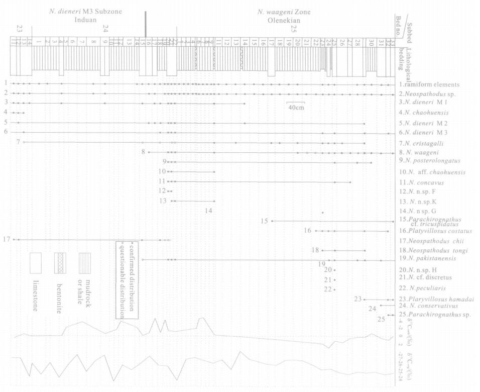
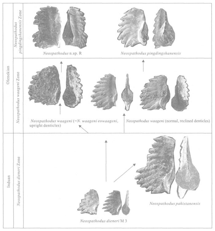
Repeated (more than ten times) conodont analyses have recovered thousands of conodont specimens which are especially rich in the Induan-Olenekian boundary strata, at the West Pingdingshan Section located in Chaohu City, Anhui Province, a candidate GSSP of the Induan-Olenekian boundary. The most distinctive forms are the conodonts of the Neospathodus dieneri group and N. waageni group, as well as some new elements. Based on the general characteristics of the Neospathodus species and their biogeographic distribution, an evolutionary lineage of the species is proposed: N. dieneri Morphotype3→N. waageni→N. pingdingshanensis, Neospathodus dieneri Morphotype3→N. waageni (upright denticles) →N. n. sp. R and Neospathodus dieneri Morphotype3→N. pakistanensis. The first occurrence of N. waageni, which is regarded as the indicator of the Induan-Olenekian boundary, is situated at 40.49 m above the boundary between the Dalong and Yinkeng formations. The recognition of this evolutionary lineage of Neospathodus is of great importance for a better understanding and definition of the Lower Triassic conodont zonation.
Repeated (more than ten times) conodont analyses have recovered thousands of conodont specimens which are especially rich in the Induan-Olenekian boundary strata, at the West Pingdingshan Section located in Chaohu City, Anhui Province, a candidate GSSP of the Induan-Olenekian boundary. The most distinctive forms are the conodonts of the Neospathodus dieneri group and N. waageni group, as well as some new elements. Based on the general characteristics of the Neospathodus species and their biogeographic distribution, an evolutionary lineage of the species is proposed: N. dieneri Morphotype3→N. waageni→N. pingdingshanensis, Neospathodus dieneri Morphotype3→N. waageni (upright denticles) →N. n. sp. R and Neospathodus dieneri Morphotype3→N. pakistanensis. The first occurrence of N. waageni, which is regarded as the indicator of the Induan-Olenekian boundary, is situated at 40.49 m above the boundary between the Dalong and Yinkeng formations. The recognition of this evolutionary lineage of Neospathodus is of great importance for a better understanding and definition of the Lower Triassic conodont zonation.

2007, 32(3): 303-312.
Abstract:
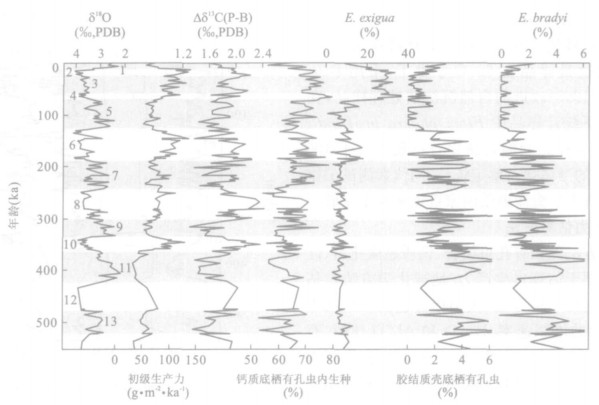
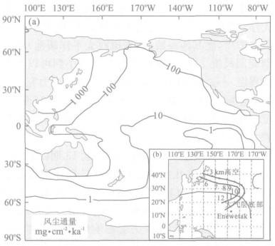
Microfossil assemblages and foraminifer isotopes from the upper part of ODP Hole 807A on the Ontong Java plateau were studied to provide evidence for discussing Late Quaternary productivity variations with glacial cycles in the western equatorial Pacific. Multi-proxy results reveal that productivity gradually increased in general since marine isotope stage (MIS) 13, and was higher in glacial times than in interglacial times. The thermocline proxies do not completely fit into glacial-interglacial cycles, but present two stages of thermocline changes: shallower before 280 ka with higher amplitude and lower frequency abundance fluctuations; deeper after 280 ka with higher frequency and lower amplitude fluctuations. The distinct modes of variations between productivity and thermocline suggest that thermocline change is not a primary controlling factor of biological productivity in the western equatorial Pacific. As the fluctuations of paleoproductivity from Hole 807A match with dust flux records from the northwest Pacific, we propose that dust carried from east central Asian is likely to be more significant in enhancing biological productivity in the western equatorial Pacific.
Microfossil assemblages and foraminifer isotopes from the upper part of ODP Hole 807A on the Ontong Java plateau were studied to provide evidence for discussing Late Quaternary productivity variations with glacial cycles in the western equatorial Pacific. Multi-proxy results reveal that productivity gradually increased in general since marine isotope stage (MIS) 13, and was higher in glacial times than in interglacial times. The thermocline proxies do not completely fit into glacial-interglacial cycles, but present two stages of thermocline changes: shallower before 280 ka with higher amplitude and lower frequency abundance fluctuations; deeper after 280 ka with higher frequency and lower amplitude fluctuations. The distinct modes of variations between productivity and thermocline suggest that thermocline change is not a primary controlling factor of biological productivity in the western equatorial Pacific. As the fluctuations of paleoproductivity from Hole 807A match with dust flux records from the northwest Pacific, we propose that dust carried from east central Asian is likely to be more significant in enhancing biological productivity in the western equatorial Pacific.


2007, 32(3): 313-321.
Abstract:
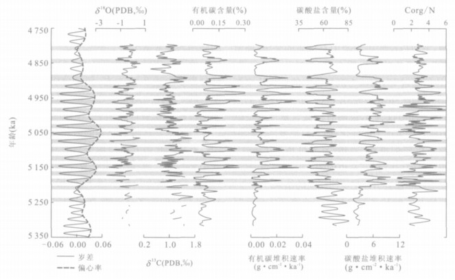
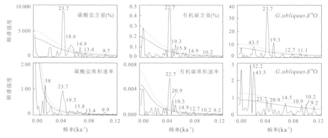
The Profile Cape Spertivento, located in the Calabria peninsula of Italy, is composed of the Early Pliocene (5.3-4.8 Ma) Mediterranean marl-clay sediments. Based on the former work, a more accurate astronomically tuned timescale has been reconstructed for the sequence Cape Spertivento in this paper. Paleoproductivity proxies show that during the Early Pliocene, the increases of the Northern Hemisphere summer insolation always concurred with the increases of the organic carbon MAR, the high C/N ratios, the decreases of the carbonate MAR, and the negative excursions of G. obliquus δ18O and δ13C, which were probably caused by the enhanced rainfall, resulting from the strengthened African summer monsoon. Moreover, the strong African summer monsoon led to the flooding of the Nile River, increasing the discharge of continental nutrients and fresh water into the Mediterranean Sea. Strong precession and abundant semi-precession cycles are found in the spectrums of the proxy records, implying the tropical forcing of the African monsoon variability during the Early Pliocene.
The Profile Cape Spertivento, located in the Calabria peninsula of Italy, is composed of the Early Pliocene (5.3-4.8 Ma) Mediterranean marl-clay sediments. Based on the former work, a more accurate astronomically tuned timescale has been reconstructed for the sequence Cape Spertivento in this paper. Paleoproductivity proxies show that during the Early Pliocene, the increases of the Northern Hemisphere summer insolation always concurred with the increases of the organic carbon MAR, the high C/N ratios, the decreases of the carbonate MAR, and the negative excursions of G. obliquus δ18O and δ13C, which were probably caused by the enhanced rainfall, resulting from the strengthened African summer monsoon. Moreover, the strong African summer monsoon led to the flooding of the Nile River, increasing the discharge of continental nutrients and fresh water into the Mediterranean Sea. Strong precession and abundant semi-precession cycles are found in the spectrums of the proxy records, implying the tropical forcing of the African monsoon variability during the Early Pliocene.


2007, 32(3): 322-328.
Abstract:
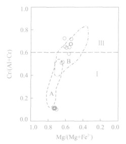
The former studies show that the Muztag ophiolite outcropped in the East Kunlun area of Xinjiang Uygur Autonomous Region formed in the supra-subduction zone environment. The petrological and mineralogical characteristics of metamorphic peridotites of this ophiolite are analyzed in order to further study the type of the subducuion zone. Thin-section observations show that the olivines of metamorphic peridotites exist in three textures: metamorphic relict, metamorphic recrystallizition and orthopyroxene-melting crystallizations. Microprobe analyses show that they have stable and low Fo range of 87.8-89.5. The orthopyroxenes show metamorphic relict and melting relict textures, with low En of 88-90 and a wide range of Al2O3 content of 2.90%-5.13%. The spinels develop xenomorphic-semi-automorphic textures, with Cr# (=Cr/ (Cr+Al)) mainly distributing in two ranges of 0.508-0.723 and 0.100-0.118, respectively. Based on the petrological and mineralogical evidences together with the era and tectonic setting of the Muztag ophiolite, it can be concluded that the ophiolite formed in the supra-subduction zone where the oceanic crust subducted down to the continental arc with thick continental crust, and resulted from ocean-to-continent subduction within the Paleotethyan archiopelagic ocean in the East Kunlun area of Xinjiang Uygur Autonomous Region.
The former studies show that the Muztag ophiolite outcropped in the East Kunlun area of Xinjiang Uygur Autonomous Region formed in the supra-subduction zone environment. The petrological and mineralogical characteristics of metamorphic peridotites of this ophiolite are analyzed in order to further study the type of the subducuion zone. Thin-section observations show that the olivines of metamorphic peridotites exist in three textures: metamorphic relict, metamorphic recrystallizition and orthopyroxene-melting crystallizations. Microprobe analyses show that they have stable and low Fo range of 87.8-89.5. The orthopyroxenes show metamorphic relict and melting relict textures, with low En of 88-90 and a wide range of Al2O3 content of 2.90%-5.13%. The spinels develop xenomorphic-semi-automorphic textures, with Cr# (=Cr/ (Cr+Al)) mainly distributing in two ranges of 0.508-0.723 and 0.100-0.118, respectively. Based on the petrological and mineralogical evidences together with the era and tectonic setting of the Muztag ophiolite, it can be concluded that the ophiolite formed in the supra-subduction zone where the oceanic crust subducted down to the continental arc with thick continental crust, and resulted from ocean-to-continent subduction within the Paleotethyan archiopelagic ocean in the East Kunlun area of Xinjiang Uygur Autonomous Region.

2007, 32(3): 329-338.
Abstract:
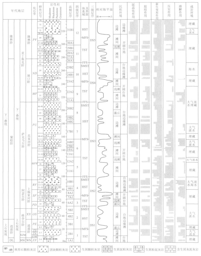
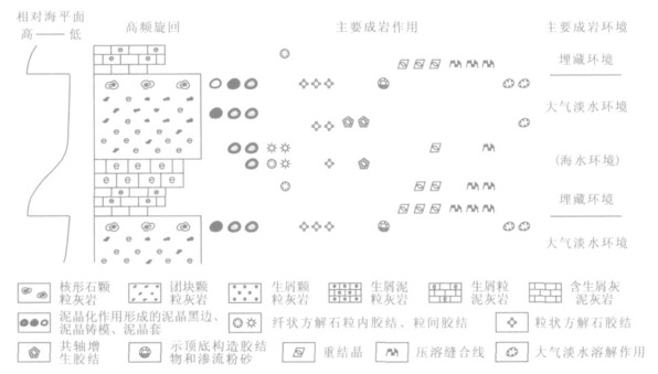
Based on the case study on the platform-facies carbonate rocks of the Carboniferous-Permian boundary section being well developed and outcropped in Xikou, Zhen'an County, Shaanxi Province, China, this paper probes into the carbonate diagenesis controlled by glacioeustatic sea-level changes and its different patterns.In terms of mineralogical composition and microfabrics, diagenetic environments in the study area are divided into marine, near surface meteoric and burial environments.Comprehensive analysis is made on all patterns of carbonate diagenesis and the vertical distribution features of diagenetic environments.The analytical results reveal that carbonate diagenesis in the Carboniferous-Permian boundary section is related to the relative stratigraphic position of the rocks in the depositional cyclothem and is controlled by the glacioeustatic sea-level changes.There are distinctive differences in diagenetic patterns between lower transgressive sequence and upper regressive sequence in a cyclothem.The former is mainly characterized by pressure solution and recrystallization of mudstone and wackstone in burial environments, while the latter by cementation and leaching of freshwater in meteoric environments.
Based on the case study on the platform-facies carbonate rocks of the Carboniferous-Permian boundary section being well developed and outcropped in Xikou, Zhen'an County, Shaanxi Province, China, this paper probes into the carbonate diagenesis controlled by glacioeustatic sea-level changes and its different patterns.In terms of mineralogical composition and microfabrics, diagenetic environments in the study area are divided into marine, near surface meteoric and burial environments.Comprehensive analysis is made on all patterns of carbonate diagenesis and the vertical distribution features of diagenetic environments.The analytical results reveal that carbonate diagenesis in the Carboniferous-Permian boundary section is related to the relative stratigraphic position of the rocks in the depositional cyclothem and is controlled by the glacioeustatic sea-level changes.There are distinctive differences in diagenetic patterns between lower transgressive sequence and upper regressive sequence in a cyclothem.The former is mainly characterized by pressure solution and recrystallization of mudstone and wackstone in burial environments, while the latter by cementation and leaching of freshwater in meteoric environments.


2007, 32(3): 339-346.
Abstract:
In the Northeast Guizhou and its surrounding, a series of black shales, covering the tilm sheet of Tiesiao Formation which is thought to be formed during the Sturtian, distributes at the bottom of Datangpo Formation, lower Nanhua Series, Neoproterozoic.Generally, the lower part of the black shales is mainly composed of carbonate such as dialogite, dolomite and so on, near the center of a succession of syngenetic fault basins.Through the studies of the carbonate outcrop in this area in terms of the field structure, mineral components and the characteristics of carbonate, oxygen and sulfur isotopes, it is shown that sulfur isotope presents distinct positive excursion in contrast with carbonate isotope that indicates an intense negative excursion.In addition, a mount of stomatal dialogite and significant structures like mud volcano, diapers and so on have been found.Based on the above features, the studied carbonate is supposed to have come into being under the same mechanisms as modern cold venting carbonate on the sea floor via the seep and release of gas hydrate and the environmental mutation.Therefore a simple conclusion is obtained that the carbonate for research is possible to be generated on the ancient ocean floor in the Proterozoic as the deposition of cold venting carbonate, because of the gas hydrate seep.This study widens the research areas for the ocean floor gas hydrate and its spatial and temporal distribution, supplying a new idea for the analysis of the diagenesis, mineralization and environmental assessment.
In the Northeast Guizhou and its surrounding, a series of black shales, covering the tilm sheet of Tiesiao Formation which is thought to be formed during the Sturtian, distributes at the bottom of Datangpo Formation, lower Nanhua Series, Neoproterozoic.Generally, the lower part of the black shales is mainly composed of carbonate such as dialogite, dolomite and so on, near the center of a succession of syngenetic fault basins.Through the studies of the carbonate outcrop in this area in terms of the field structure, mineral components and the characteristics of carbonate, oxygen and sulfur isotopes, it is shown that sulfur isotope presents distinct positive excursion in contrast with carbonate isotope that indicates an intense negative excursion.In addition, a mount of stomatal dialogite and significant structures like mud volcano, diapers and so on have been found.Based on the above features, the studied carbonate is supposed to have come into being under the same mechanisms as modern cold venting carbonate on the sea floor via the seep and release of gas hydrate and the environmental mutation.Therefore a simple conclusion is obtained that the carbonate for research is possible to be generated on the ancient ocean floor in the Proterozoic as the deposition of cold venting carbonate, because of the gas hydrate seep.This study widens the research areas for the ocean floor gas hydrate and its spatial and temporal distribution, supplying a new idea for the analysis of the diagenesis, mineralization and environmental assessment.


2007, 32(3): 347-356.
Abstract:
During Eocene period, rapid subsidence occurred in the Yinggehai basin where more than 17 km of sedimentary cover has been accumulated.According to the analogue modeling experiments, the rigid massif on the Indochina block could be one of the most important factors contributing to the strong subsidence and high sedimentation rate of the basin.Combined the geological analysis with analogue modeling experiments, the evolution of the Yinggehai basin could be divided into four main stages: (1) Before 42 Ma, controlled by the southeastward extension of the Beibu Gulf basin on the northern continental margin, the Yinggehai basin experienced dextral pull-apart.Bounded by NS-trending Yingxi fault, the transtensional areas mainly are the northwest part and along the eastern boundary of the basin. (2) From 42 to 21 Ma, the development of the main rift body in Yinggehai basin was mainly controlled by the southward slip and clockwise rotation of the Indochina block along the Red River fault zone, and the sedimentation was strengthened due to the sinistral transtension.In the east, the subsidence is deepened due to the dextral transtension. (3) From 21 to 10.4 Ma, the sinistral movement of the Indochina block slowed down to still.From 21 to 15.5 Ma, the northwest part of the basin began to inverse locally because of post-rift thermal subsidence of the whole basin. (4) From 10.4 Ma to present, the basin was affected by the dextral movement of the South China block along the Red River fault zone and thermal accident in a new phase at 5 Ma.
During Eocene period, rapid subsidence occurred in the Yinggehai basin where more than 17 km of sedimentary cover has been accumulated.According to the analogue modeling experiments, the rigid massif on the Indochina block could be one of the most important factors contributing to the strong subsidence and high sedimentation rate of the basin.Combined the geological analysis with analogue modeling experiments, the evolution of the Yinggehai basin could be divided into four main stages: (1) Before 42 Ma, controlled by the southeastward extension of the Beibu Gulf basin on the northern continental margin, the Yinggehai basin experienced dextral pull-apart.Bounded by NS-trending Yingxi fault, the transtensional areas mainly are the northwest part and along the eastern boundary of the basin. (2) From 42 to 21 Ma, the development of the main rift body in Yinggehai basin was mainly controlled by the southward slip and clockwise rotation of the Indochina block along the Red River fault zone, and the sedimentation was strengthened due to the sinistral transtension.In the east, the subsidence is deepened due to the dextral transtension. (3) From 21 to 10.4 Ma, the sinistral movement of the Indochina block slowed down to still.From 21 to 15.5 Ma, the northwest part of the basin began to inverse locally because of post-rift thermal subsidence of the whole basin. (4) From 10.4 Ma to present, the basin was affected by the dextral movement of the South China block along the Red River fault zone and thermal accident in a new phase at 5 Ma.


2007, 32(3): 357-365.
Abstract:
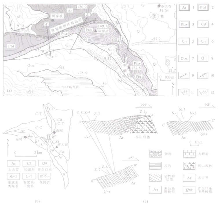
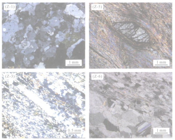
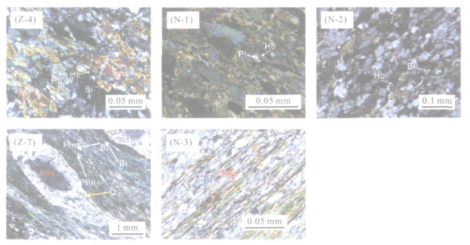
The basement ductile shear zone of the Fangshan extensional dome separates the Archean Guandi complex from various cover strata in southern and northern margins of Fangshan pluton.This ductile shear zone is composed of the ductilely deformed fabrics with an SE-ward kinematic, which can be deduced from rock and mineral deformations, including faultage offect and so on, on both macroscopic and microcosmic scales.Typical regional-dynamic metamorphic mineral pair hornblende-plagioclase and high pressure mineral muscovite with high Si are common and identified within the ductile shear zone.EPMA analysis of the mineral pair gives a metamorphic condition of T=492-555 ℃ and p=0.33 GPa, which indicates a metamorphic grade of lower-amphibolite facies and a depth of around 12.9 km estimated following a normal lithostatic pressure.Field evidences, including that Fangshan pluton intruded the Archean Guandi complex and the ductile shear zone, lots of gneissic xenolithes within the Fangshan pluton, and that a lot of quartz monzonite-diorite intruded along the fabric of the ductile shear zone, support that the ductile shear zone was formed before Fangshan pluton, and likely to be simultaneous with the formation of the Fangshan detachment zone of the extensional dome.
The basement ductile shear zone of the Fangshan extensional dome separates the Archean Guandi complex from various cover strata in southern and northern margins of Fangshan pluton.This ductile shear zone is composed of the ductilely deformed fabrics with an SE-ward kinematic, which can be deduced from rock and mineral deformations, including faultage offect and so on, on both macroscopic and microcosmic scales.Typical regional-dynamic metamorphic mineral pair hornblende-plagioclase and high pressure mineral muscovite with high Si are common and identified within the ductile shear zone.EPMA analysis of the mineral pair gives a metamorphic condition of T=492-555 ℃ and p=0.33 GPa, which indicates a metamorphic grade of lower-amphibolite facies and a depth of around 12.9 km estimated following a normal lithostatic pressure.Field evidences, including that Fangshan pluton intruded the Archean Guandi complex and the ductile shear zone, lots of gneissic xenolithes within the Fangshan pluton, and that a lot of quartz monzonite-diorite intruded along the fabric of the ductile shear zone, support that the ductile shear zone was formed before Fangshan pluton, and likely to be simultaneous with the formation of the Fangshan detachment zone of the extensional dome.


2007, 32(3): 366-372.
Abstract:
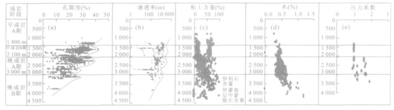
The mechanism of pore evolution is significant to the research of deeper reservoir controlling factors, predicting the favorable reservoir and subtle reservoirs exploration in middle-deep strata.The pore evolution analysis of Liaozhong sag, Liaoxi uplift and Liaoxi sag in Liaodong Bay area were analyzed, which indicates that there are four similar secondary pore zones during the whole porosity reduction current background in different sags and uplifts.The only difference is that the depth of secondary pore development in sag is deeper than that in the uplift, and the secondary pore zone is related to the diagenesis, organic evolution, clay mineral evolution, overpressure and early oil and gas injection.This paper discusses the mechanism of the porosity loss and the secondary pores development, and the emphasis is placed on the analysis of the relation among the pore evolution, diagenesis, organic evolution, clay mineral evolution, early oil and gas injection and overpressure.On the basis of the discussion, it is pointed out that the formation of the four sencondary pore development zones is due to the dissolution of the carbonate cement, feldspar and the clastic debris by the organic acid, and the protection from the overpressure and the early oil and gas injection.
The mechanism of pore evolution is significant to the research of deeper reservoir controlling factors, predicting the favorable reservoir and subtle reservoirs exploration in middle-deep strata.The pore evolution analysis of Liaozhong sag, Liaoxi uplift and Liaoxi sag in Liaodong Bay area were analyzed, which indicates that there are four similar secondary pore zones during the whole porosity reduction current background in different sags and uplifts.The only difference is that the depth of secondary pore development in sag is deeper than that in the uplift, and the secondary pore zone is related to the diagenesis, organic evolution, clay mineral evolution, overpressure and early oil and gas injection.This paper discusses the mechanism of the porosity loss and the secondary pores development, and the emphasis is placed on the analysis of the relation among the pore evolution, diagenesis, organic evolution, clay mineral evolution, early oil and gas injection and overpressure.On the basis of the discussion, it is pointed out that the formation of the four sencondary pore development zones is due to the dissolution of the carbonate cement, feldspar and the clastic debris by the organic acid, and the protection from the overpressure and the early oil and gas injection.


2007, 32(3): 373-380.
Abstract:
Xiejiagou gold deposit, discovered in 2002, is located in the southwest of Zhaoyuan City, Shandong Province.The detailed study of macroscopic and microscopic perspectives of ores in Xiejiagou gold deposit reveals two types of gold-bearing ores: primary ores and oxidized ores.The primary ores, classified as pyritization and sericitization-silication granite, chalcopyritization-pyritization and sericitization-silication granite, multi-sulfide and sericitization-silication granite, and chalcopyrite-pyrite quartz vein, are located at different positions in the brittle-ducility shear-zone, reflecting 2 periods and 5 stages of metallization process.The gold occurred mainly in gold inclusion, between minerals and in cracks.The average gold fineness is 859.96 in gold inclusion, 843.83 between minerals, and 833.08 in cracks, respectively, indicating that the gold mineralization occurred in the middle and deep layers and that the temperature of mineralization decreased gradually from the gold inclusion, between minerals and in crack.
Xiejiagou gold deposit, discovered in 2002, is located in the southwest of Zhaoyuan City, Shandong Province.The detailed study of macroscopic and microscopic perspectives of ores in Xiejiagou gold deposit reveals two types of gold-bearing ores: primary ores and oxidized ores.The primary ores, classified as pyritization and sericitization-silication granite, chalcopyritization-pyritization and sericitization-silication granite, multi-sulfide and sericitization-silication granite, and chalcopyrite-pyrite quartz vein, are located at different positions in the brittle-ducility shear-zone, reflecting 2 periods and 5 stages of metallization process.The gold occurred mainly in gold inclusion, between minerals and in cracks.The average gold fineness is 859.96 in gold inclusion, 843.83 between minerals, and 833.08 in cracks, respectively, indicating that the gold mineralization occurred in the middle and deep layers and that the temperature of mineralization decreased gradually from the gold inclusion, between minerals and in crack.

2007, 32(3): 381-388.
Abstract:
Plate tectonics is a global structure theory.It takes the sea-floor spreading, oceanic crust subduction, and transform fault as main active forms and mantle convection as an original dynamic.Despite the fact that plate tectonic theory has been established with a popular acceptance, there are some important problems expecting to be resolved.The mainly reason is that its conception of mantle convection is not very convincing enough and it fails to explain the dynamic mechanism of sea-land shift.After the illustration of the chief reasons causing these difficult problems on the plate tectonic theory, the instance and dynamic action of collision of a celestial body with the earth is introduced in the paper.It is emphasized that large-scale collision plays such an important part in the global tectonic activity that the plate tectonics is no exception also and the intensive impact of a celestial body with the Earth is able to cause the crack of sea-floor or continent.So we can use the pattern of the crack caused by the collision of a celestial body with the Earth induces the uprising of magma by the subtraction of pressure (might simply be named "Impacted crack induce magma uprising pattern") to supplant the pattern of mantle convection which is featured with collision with the layer texture in Earth interior in order to explain the sea-floor spreading, and take the random variability of the spot of the collision as the main reason of large-scale sea-land shift.Thus it could be useful to solve the two main problems of the plate tectonic theory mentioned above.
Plate tectonics is a global structure theory.It takes the sea-floor spreading, oceanic crust subduction, and transform fault as main active forms and mantle convection as an original dynamic.Despite the fact that plate tectonic theory has been established with a popular acceptance, there are some important problems expecting to be resolved.The mainly reason is that its conception of mantle convection is not very convincing enough and it fails to explain the dynamic mechanism of sea-land shift.After the illustration of the chief reasons causing these difficult problems on the plate tectonic theory, the instance and dynamic action of collision of a celestial body with the earth is introduced in the paper.It is emphasized that large-scale collision plays such an important part in the global tectonic activity that the plate tectonics is no exception also and the intensive impact of a celestial body with the Earth is able to cause the crack of sea-floor or continent.So we can use the pattern of the crack caused by the collision of a celestial body with the Earth induces the uprising of magma by the subtraction of pressure (might simply be named "Impacted crack induce magma uprising pattern") to supplant the pattern of mantle convection which is featured with collision with the layer texture in Earth interior in order to explain the sea-floor spreading, and take the random variability of the spot of the collision as the main reason of large-scale sea-land shift.Thus it could be useful to solve the two main problems of the plate tectonic theory mentioned above.


2007, 32(3): 389-396.
Abstract:
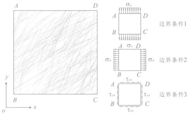
It is very important to determine deformability parameters in the simulation of stability of rock masses.A model to determine equivalent deformability parameters through regular and irregular fractures in rock mass is put forward in the paper.The research of deformability property of rock mass without consideration of the coupling behavior indicates that the equivalent deformability parameters are not only related to the length, orientation and deformability property of discontinuities, but also related to the connection of each group of discontinuities.It is found that the REVs of rock masses is of several important properties.Firstly, REVs has multi-scale effect and uncertainty properties.Secondly, REVs alter with the change of the geometrical properties of the network: REVs is smaller in the case of longer length, higher density and more disorder of orientation.The diversity between the deformability parameters of rock blocks and discontinuity has no effect on the value of REVs, while, if the deformability parameters of different groups of discontinuities become more consistent, the value of REVs is smaller.
It is very important to determine deformability parameters in the simulation of stability of rock masses.A model to determine equivalent deformability parameters through regular and irregular fractures in rock mass is put forward in the paper.The research of deformability property of rock mass without consideration of the coupling behavior indicates that the equivalent deformability parameters are not only related to the length, orientation and deformability property of discontinuities, but also related to the connection of each group of discontinuities.It is found that the REVs of rock masses is of several important properties.Firstly, REVs has multi-scale effect and uncertainty properties.Secondly, REVs alter with the change of the geometrical properties of the network: REVs is smaller in the case of longer length, higher density and more disorder of orientation.The diversity between the deformability parameters of rock blocks and discontinuity has no effect on the value of REVs, while, if the deformability parameters of different groups of discontinuities become more consistent, the value of REVs is smaller.


2007, 32(3): 397-402.
Abstract:
Research and development of fast, economic and effective controlling method and theory of landslide has always been the focus of anti-sliding projects for all the countries.In this research, a new kind of economic and suitable Ionic Soil Stabilizer (ISS for short) for improving the shear strength of sliding soil is studied.The sliding soil is treated by different matches of ISS and water at first, then is tested in the Atterberg limits test, direct shear test, routine consolidation test and free swell test.The results show that the plastic index decreases, and the cohesion increases and the void-ratio deflates and the free swell shrinks after mixing the ISS into the sliding soil of landslide.The mechanism is that the sliding soil that consists mainly of clay soil is mixed with ISS, which can replace the exchangeable cationic of clay surface, changes the pair-electricity layer of soil grain surface, reduces the thickness of adsorbed water, transforms the hydrophilic sliding soil to the hydrophobic and increases the shear strength of sliding soil by the function of physics and chemistry.
Research and development of fast, economic and effective controlling method and theory of landslide has always been the focus of anti-sliding projects for all the countries.In this research, a new kind of economic and suitable Ionic Soil Stabilizer (ISS for short) for improving the shear strength of sliding soil is studied.The sliding soil is treated by different matches of ISS and water at first, then is tested in the Atterberg limits test, direct shear test, routine consolidation test and free swell test.The results show that the plastic index decreases, and the cohesion increases and the void-ratio deflates and the free swell shrinks after mixing the ISS into the sliding soil of landslide.The mechanism is that the sliding soil that consists mainly of clay soil is mixed with ISS, which can replace the exchangeable cationic of clay surface, changes the pair-electricity layer of soil grain surface, reduces the thickness of adsorbed water, transforms the hydrophilic sliding soil to the hydrophobic and increases the shear strength of sliding soil by the function of physics and chemistry.
2007, 32(3): 403-408.
Abstract:
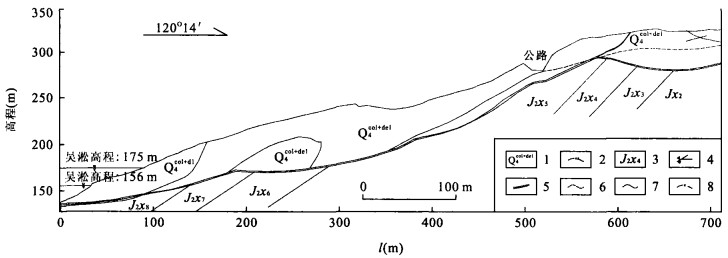
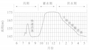
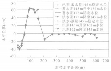
After the operation of Three Gorges reservoir,the water level of the reservoir will fluctuate in the range of 145 m-162 m-175 m.Water level fluctuation will soften the rock and soil on the bank and induce the underground water fluctuation and decrease the shear strength,which will influence the landslide stability.Therefore,landslide stability evaluation under the reservoir running is necessary and important.Jinle landslide is one of the large and complicated landslides in this area.Based on the engineering geological condition investigation results,the formation mechanism is analyzed.The 2D finite element model is developed and the rational calculation parameters of the rock and soil are chosen.With ICFEP software,7 simulations are done according to the reservoir run curve.The results show that: (1) in the natural state,Jinle landslide is stable; (2) when the water level is impounding,the stability of the landslide front edge is better than the corresponding stable water levels; (3) when water level falls,the front edge of the landslide will fail; especially when the water level drops rapidly from 162 m to 145 m the front edge of the landslide will fail,meanwhile it is possible subject to progressive failure in the front and middle parts of the landslide; (4) the deformation and failure of the Jinle landslide is pulling and progressive failure mode.During the first water level fluctuation period,the whole landslide can stay stable.The front part of this landslide should be improved.
After the operation of Three Gorges reservoir,the water level of the reservoir will fluctuate in the range of 145 m-162 m-175 m.Water level fluctuation will soften the rock and soil on the bank and induce the underground water fluctuation and decrease the shear strength,which will influence the landslide stability.Therefore,landslide stability evaluation under the reservoir running is necessary and important.Jinle landslide is one of the large and complicated landslides in this area.Based on the engineering geological condition investigation results,the formation mechanism is analyzed.The 2D finite element model is developed and the rational calculation parameters of the rock and soil are chosen.With ICFEP software,7 simulations are done according to the reservoir run curve.The results show that: (1) in the natural state,Jinle landslide is stable; (2) when the water level is impounding,the stability of the landslide front edge is better than the corresponding stable water levels; (3) when water level falls,the front edge of the landslide will fail; especially when the water level drops rapidly from 162 m to 145 m the front edge of the landslide will fail,meanwhile it is possible subject to progressive failure in the front and middle parts of the landslide; (4) the deformation and failure of the Jinle landslide is pulling and progressive failure mode.During the first water level fluctuation period,the whole landslide can stay stable.The front part of this landslide should be improved.


2007, 32(3): 409-414.
Abstract:
With Yujianhe hydraulic engineering as the background and on the basis of geological module and boundary conditions of Liding dam, a 3-D mathematic and mechanical module was constructed to study the influence of different deformation modules on stress distribution by ANSYS software.The result indicates: (1) The maximum principal stresses are chiefly distributed at the bottom of the dam and close to weak intercalated layers; (2) The deformation module of weak intercalated layers affects the stresses of abutment and crown of the arch, and when it is less than 0.5 GPa, the differences of stresses are obvious; (3) When the foundation is composed of three materials, the maximum tensile and compressive stresses exist about 10-15 m to the top of the weak intercalated layers rather than at the top of them.This conclusion provides a theoretical basis for the optimal design for arch dam and dam treatment.
With Yujianhe hydraulic engineering as the background and on the basis of geological module and boundary conditions of Liding dam, a 3-D mathematic and mechanical module was constructed to study the influence of different deformation modules on stress distribution by ANSYS software.The result indicates: (1) The maximum principal stresses are chiefly distributed at the bottom of the dam and close to weak intercalated layers; (2) The deformation module of weak intercalated layers affects the stresses of abutment and crown of the arch, and when it is less than 0.5 GPa, the differences of stresses are obvious; (3) When the foundation is composed of three materials, the maximum tensile and compressive stresses exist about 10-15 m to the top of the weak intercalated layers rather than at the top of them.This conclusion provides a theoretical basis for the optimal design for arch dam and dam treatment.


2007, 32(3): 415-419.
Abstract:
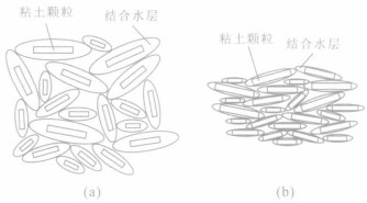
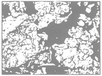
Based on soil experimental technique and computer image processing, a method to gain the structural parameters of soil samples by using SEM photos has been discussed, and an example of remolded cohesive soil is offered.To gain structural parameters, three steps to process SEM photos are taken: photo transformation, edge detection and color-filling.Pore structural parameters of soil are calculated through color-filled binary images.12 samples of remolded cohesive soil with different moisture and density states have been selected to test the method.SEM photos in 3 scales have been taken for each sample, i.e.500×, 1 000× and 2 000×.Then all the SEM photos have been processed and plane porosity and void ratio have been calculated with Matlab.According to data analysis, some conclusions can be made as follows.Firstly, pore structural parameters calculated through SEM photos are relevant to those calculated through three-phase diagram and pore structural characteristics of soil can be reflected by them.Secondly, pore structural parameters calculated through SEM photos are influenced by the way of drying SEM samples.Those of air-dried samples are larger than the results of three-phase diagram, while those of heat-dried are smaller.Thirdly, pore structural parameters of the same sample calculated through SEM photos of different scales differ from each other and they fluctuate around those of three-phase diagram.Therefore, it is both feasible and effective to obtain pore structural parameters by SEM image processing and analysis.
Based on soil experimental technique and computer image processing, a method to gain the structural parameters of soil samples by using SEM photos has been discussed, and an example of remolded cohesive soil is offered.To gain structural parameters, three steps to process SEM photos are taken: photo transformation, edge detection and color-filling.Pore structural parameters of soil are calculated through color-filled binary images.12 samples of remolded cohesive soil with different moisture and density states have been selected to test the method.SEM photos in 3 scales have been taken for each sample, i.e.500×, 1 000× and 2 000×.Then all the SEM photos have been processed and plane porosity and void ratio have been calculated with Matlab.According to data analysis, some conclusions can be made as follows.Firstly, pore structural parameters calculated through SEM photos are relevant to those calculated through three-phase diagram and pore structural characteristics of soil can be reflected by them.Secondly, pore structural parameters calculated through SEM photos are influenced by the way of drying SEM samples.Those of air-dried samples are larger than the results of three-phase diagram, while those of heat-dried are smaller.Thirdly, pore structural parameters of the same sample calculated through SEM photos of different scales differ from each other and they fluctuate around those of three-phase diagram.Therefore, it is both feasible and effective to obtain pore structural parameters by SEM image processing and analysis.


2007, 32(3): 420-424.
Abstract:
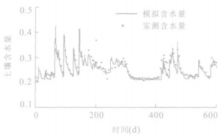
Preferential flow is one of main forms of infiltration recharge from rainfall and irrigation to groundwater.It has the characteristics of rapid flow rate, complicated flow path and being very difficult to be quantified.To quantify the preferential flow in the infiltration recharge process and its percentage in total infiltration recharge, a new method has been developed based on the measured infiltration recharge of lysimeters in Zhengzhou Groundwater Balance Test Field.The numerical simulation model that can describe the piston flow in lysimeters by rechards equation was constructed and calibrated according to the soil hydraulic parameters, weather data and so on.The surplus part in the calculated flux can be regarded as the preferential flow because the preferential flow flows faster than piston flow and reaches groundwater earlier.By comparing the measured recharge flux and calculated recharge flux, the quantity of preferential flow and its percentage in total precipitation infiltration recharge can be determined.The preferential flow makes up 10%-80% in total precipitation infiltration recharge.The percentage is higher when the soil contains more clay, and the percentage is lower when the groundwater level is deeper.
Preferential flow is one of main forms of infiltration recharge from rainfall and irrigation to groundwater.It has the characteristics of rapid flow rate, complicated flow path and being very difficult to be quantified.To quantify the preferential flow in the infiltration recharge process and its percentage in total infiltration recharge, a new method has been developed based on the measured infiltration recharge of lysimeters in Zhengzhou Groundwater Balance Test Field.The numerical simulation model that can describe the piston flow in lysimeters by rechards equation was constructed and calibrated according to the soil hydraulic parameters, weather data and so on.The surplus part in the calculated flux can be regarded as the preferential flow because the preferential flow flows faster than piston flow and reaches groundwater earlier.By comparing the measured recharge flux and calculated recharge flux, the quantity of preferential flow and its percentage in total precipitation infiltration recharge can be determined.The preferential flow makes up 10%-80% in total precipitation infiltration recharge.The percentage is higher when the soil contains more clay, and the percentage is lower when the groundwater level is deeper.


2007, 32(3): 425-432.
Abstract:
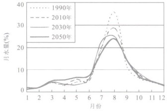
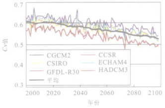
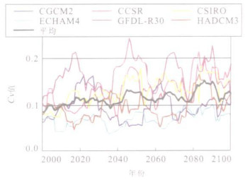
In recent years, climate change, with its far-reaching influences, has emerged as a popular issue.Among the various aspects of climate change, its impact on the terrestrial water cycle has been regarded as one of the most important issues, because it directly affects human settlement and ecosystem.The paper reviews previous studies first, and then pointed out their weakness and future research focuses.As practices, the impacts of climate change on surface runoff and water resources in Shanxi Province and the head region of Yellow River were studied here.And results of 7 Global Climate Models (GCMs) in the Third Assessment report of the Intergovernmental Panel on Climate Change from IPCC Data Distribution Center web page was employed as future potential climate change.Different distributed hydrologic models based on local underlying surface were developed in order to evaluate the impacts on water resources.Future potential climate change of Shanxi Province were assessed by integrating outputs of GCMs, whereas which of the head region of Yellow River were come from results of different GCMs directly.Conclusionsshow that both precipitation and temperature of Shanxi Province would be increasing before 2050, but the surface water resources would increase before 2030 and then decrease, because the impact of future temperature increase on runoff would be less than that of precipitation increase before 2030 but more than it after 2030.And on the head region of Yellow River, temperature and precipitation would also increase.But the quantity of runoff would be decreasing in next 100 years for the region belongs to high and cold areas, which would make the impact of temperature increase on runoff larger than that of precipitation.And the distribution of runoff would be more even in years but more uneven among years, the latter may imply the higher possibility of drought and flood.
In recent years, climate change, with its far-reaching influences, has emerged as a popular issue.Among the various aspects of climate change, its impact on the terrestrial water cycle has been regarded as one of the most important issues, because it directly affects human settlement and ecosystem.The paper reviews previous studies first, and then pointed out their weakness and future research focuses.As practices, the impacts of climate change on surface runoff and water resources in Shanxi Province and the head region of Yellow River were studied here.And results of 7 Global Climate Models (GCMs) in the Third Assessment report of the Intergovernmental Panel on Climate Change from IPCC Data Distribution Center web page was employed as future potential climate change.Different distributed hydrologic models based on local underlying surface were developed in order to evaluate the impacts on water resources.Future potential climate change of Shanxi Province were assessed by integrating outputs of GCMs, whereas which of the head region of Yellow River were come from results of different GCMs directly.Conclusionsshow that both precipitation and temperature of Shanxi Province would be increasing before 2050, but the surface water resources would increase before 2030 and then decrease, because the impact of future temperature increase on runoff would be less than that of precipitation increase before 2030 but more than it after 2030.And on the head region of Yellow River, temperature and precipitation would also increase.But the quantity of runoff would be decreasing in next 100 years for the region belongs to high and cold areas, which would make the impact of temperature increase on runoff larger than that of precipitation.And the distribution of runoff would be more even in years but more uneven among years, the latter may imply the higher possibility of drought and flood.


2007, 32(3): 433-440.
Abstract:
This paper aims at analyzing by SPSS software the manufacture and commercialization conditions of RDF from carbon black of wood chips.The optimal manufacture conditions were determined by correlation analyses between the commercial application requirements (compression strength, volatile content & heat value) and control parameters (additive, press temperature & press stress).And, the optimal application conditions were determined by combustion temperature, released heat, combustion duration, ash content, moisture content, total sulfur content & combustion phenomena in addition to the basic property comparison between commercial charcoal & the RDF.Finally, the analysis of the market indicated the competitive advantages of RDF in both price and environmental benefit.By taking the technical feasibilities and economic evaluation into account, the optimal manufacture conditions of the RDF are: 5% PVA-1000 additive, 150 ℃ press temperature, 130 kg/cm2 press stress for fitting the specifications of the present commercial charcoal.The optimal application conditions are: 550 ℃ reach combustion temperature, 350 ℃ average combustion temperature, heating value 24.284 MJ and 87 min/kg combustion duration.Different from the commercial charcoal, the RDF is characterized by uniform heat release, clean smell and low NOx and SOx emission during the combustion.In addition, particle emission also accords with the emission regulations of Taiwan and its shape remains unchanged after combustion.The competitive marketing price is estimated to be 6 Nt$/㎏.With great environmental and economic benefit, the RDF is bound to be popular in the market.
This paper aims at analyzing by SPSS software the manufacture and commercialization conditions of RDF from carbon black of wood chips.The optimal manufacture conditions were determined by correlation analyses between the commercial application requirements (compression strength, volatile content & heat value) and control parameters (additive, press temperature & press stress).And, the optimal application conditions were determined by combustion temperature, released heat, combustion duration, ash content, moisture content, total sulfur content & combustion phenomena in addition to the basic property comparison between commercial charcoal & the RDF.Finally, the analysis of the market indicated the competitive advantages of RDF in both price and environmental benefit.By taking the technical feasibilities and economic evaluation into account, the optimal manufacture conditions of the RDF are: 5% PVA-1000 additive, 150 ℃ press temperature, 130 kg/cm2 press stress for fitting the specifications of the present commercial charcoal.The optimal application conditions are: 550 ℃ reach combustion temperature, 350 ℃ average combustion temperature, heating value 24.284 MJ and 87 min/kg combustion duration.Different from the commercial charcoal, the RDF is characterized by uniform heat release, clean smell and low NOx and SOx emission during the combustion.In addition, particle emission also accords with the emission regulations of Taiwan and its shape remains unchanged after combustion.The competitive marketing price is estimated to be 6 Nt$/㎏.With great environmental and economic benefit, the RDF is bound to be popular in the market.
