2007 Vol. 32, No. 4
Display Method:
2007, 32(4): 441-452.
 PDF 3247KB
Abstract:
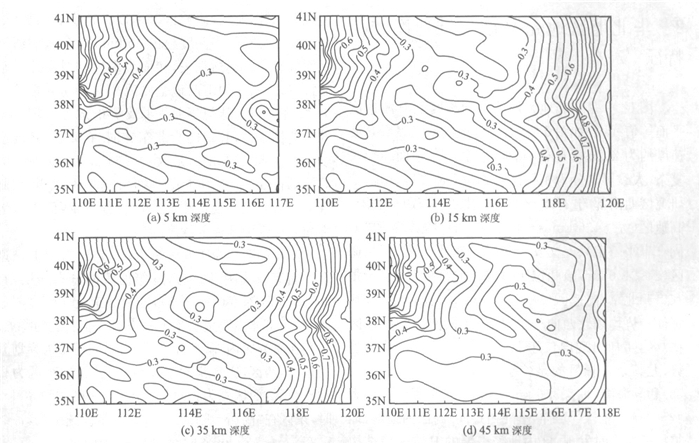
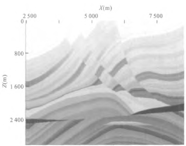
To research the velocity structure of crust and upper mantle, China Earthquake Administration has finished more than thirty deep seismic sounding (DSS) profiles, altogether about twenty thousand kilometers long in North China since the 1968 Xingtai earthquake. But these researches have not given out a 3D velocity structure model of the crust of North China and can not provide seismic evidence for researching deep structure features of the crust of North China. So based on the published research papers on DSS profiles, a 3D velocity structure model of North China is obtained by using vectorization function of GIS soft (Arc/Info) and Kriging regularization. With this velocity structure model, we have come to the following conclusions: (1) P-wave velocity of the shallow crust of North China changes rapidly, and the velocity structure is complex at the same depth. In general, it can be divided into three velocity zones, mainly tending to North West. In the research area, the lowest velocity zone is the Haihe plain and Bohai bay low-velocity zone. Geological structure of upper crust is inherited by deposit shell partially, but there are also lots of differences between them. (2) Generally, P-wave velocity increases with depth in the research zone, but it is inversed in local zones. Haihe plain low-velocity anomalous zone in the east disappeared, and Shanxi valley in the west is characterized by low velocity anomaly. The crust is divided into east part and west part by Taihang mountain. The strike of the strata above crystal floor is not completely consistent between the east part and the west one. The strike of Huanghai block and Huaihai block in the east mainly tends towards north-east, while the strike of Shanxi block and the eastern edge of Ordos block in the west mainly tends towards north-west. (3) According to the feature of Moho, the crust of the research zone can be divided into six parts: in the Shanxi block, Moho looks like a nearly north-south sunk belt, and the crust is thick; at the southern edge of the Inner Mongolia block and in the south of Yanshan block, Moho presents the structural features of fold belt, tending nearly towards east-west; at the eastern edge of Ordos block, the structure of Moho is relatively complex with nearly northwest folds.
To research the velocity structure of crust and upper mantle, China Earthquake Administration has finished more than thirty deep seismic sounding (DSS) profiles, altogether about twenty thousand kilometers long in North China since the 1968 Xingtai earthquake. But these researches have not given out a 3D velocity structure model of the crust of North China and can not provide seismic evidence for researching deep structure features of the crust of North China. So based on the published research papers on DSS profiles, a 3D velocity structure model of North China is obtained by using vectorization function of GIS soft (Arc/Info) and Kriging regularization. With this velocity structure model, we have come to the following conclusions: (1) P-wave velocity of the shallow crust of North China changes rapidly, and the velocity structure is complex at the same depth. In general, it can be divided into three velocity zones, mainly tending to North West. In the research area, the lowest velocity zone is the Haihe plain and Bohai bay low-velocity zone. Geological structure of upper crust is inherited by deposit shell partially, but there are also lots of differences between them. (2) Generally, P-wave velocity increases with depth in the research zone, but it is inversed in local zones. Haihe plain low-velocity anomalous zone in the east disappeared, and Shanxi valley in the west is characterized by low velocity anomaly. The crust is divided into east part and west part by Taihang mountain. The strike of the strata above crystal floor is not completely consistent between the east part and the west one. The strike of Huanghai block and Huaihai block in the east mainly tends towards north-east, while the strike of Shanxi block and the eastern edge of Ordos block in the west mainly tends towards north-west. (3) According to the feature of Moho, the crust of the research zone can be divided into six parts: in the Shanxi block, Moho looks like a nearly north-south sunk belt, and the crust is thick; at the southern edge of the Inner Mongolia block and in the south of Yanshan block, Moho presents the structural features of fold belt, tending nearly towards east-west; at the eastern edge of Ordos block, the structure of Moho is relatively complex with nearly northwest folds.


2007, 32(4): 453-460.
Abstract:
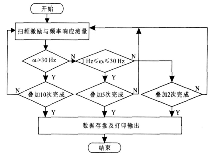
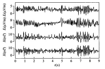
Although the magnetotelluric sounding method applied to land is mature, many technical problems arise when they are transplanted into the seafloor environment, one of which is how to put magnetic field sensors down to the seafloor to complete measurements. To protect magnetic field sensors from intense erosion and high pressure, suitable sealed pressure cases must be designed. Considering the magnetic measurement and seafloor operation, the sealed pressure case should be nonmagnetic and transportable. Among all optional materials, LC4 super-hard aluminum alloy has the highest performance to price ratio. However, it doesn′t mean that the sealed pressure case made by LC4 will be perfect in performance. In fact, because of its weak magnetism, the pressure case made by LC4 has distorting effect on frequency responses of the magnetic field sensors sealed in it. This distorting effect doesn′t affect the use of the magnetic field sensor, but if we want to eliminate its impact, we should study it through experimental measurements. In our experimental tests, we used frequency swept magnetic field as excitation signal, and then measured responses of the magnetic field sensor before and after being loaded into the sealed pressure case. Ultimately, we obtained normalized abnormal curves for the frequency responses, through which we could reveal how the sealed pressure case impacts the responses of the magnetic field sensor. Experiment results suggest that the response distortion induced by the sealed pressure case appears in the mid and high frequency area. Using experiment results as standardized data, the frequency responses collected by seafloor magnetotelluric measurements can be corrected to produce authentic information about the seafloor field source.
Although the magnetotelluric sounding method applied to land is mature, many technical problems arise when they are transplanted into the seafloor environment, one of which is how to put magnetic field sensors down to the seafloor to complete measurements. To protect magnetic field sensors from intense erosion and high pressure, suitable sealed pressure cases must be designed. Considering the magnetic measurement and seafloor operation, the sealed pressure case should be nonmagnetic and transportable. Among all optional materials, LC4 super-hard aluminum alloy has the highest performance to price ratio. However, it doesn′t mean that the sealed pressure case made by LC4 will be perfect in performance. In fact, because of its weak magnetism, the pressure case made by LC4 has distorting effect on frequency responses of the magnetic field sensors sealed in it. This distorting effect doesn′t affect the use of the magnetic field sensor, but if we want to eliminate its impact, we should study it through experimental measurements. In our experimental tests, we used frequency swept magnetic field as excitation signal, and then measured responses of the magnetic field sensor before and after being loaded into the sealed pressure case. Ultimately, we obtained normalized abnormal curves for the frequency responses, through which we could reveal how the sealed pressure case impacts the responses of the magnetic field sensor. Experiment results suggest that the response distortion induced by the sealed pressure case appears in the mid and high frequency area. Using experiment results as standardized data, the frequency responses collected by seafloor magnetotelluric measurements can be corrected to produce authentic information about the seafloor field source.


2007, 32(4): 461-468.
Abstract:
The upper spontaneous potential produced by oil and gas accumulation remains with stable potential field. Its intensity is in direct ratio to the content of the source and in inverse ratio to the radius apart from the source. Theoretical researches and practice show that abnormalities of spontaneous potential can indicate oil-bearing sandstone and locate oil-and-gas-enriched area. In oil area which is devoid of sufficient reservoir beds, the thickness of the petroleum reservoir can be predicted by determining the linear relationship between potential intensity and apparent effective thickness. In Weixing field, which is devoid of sufficient reservoir beds, its apparent effective thickness can be predicted by the linear equation. Based on the geological research and by applying spontaneous potential, the effective thickness is predicted for selecting the most appropriate drill sites to increase the possibility of successful well boring for the next round progressive development.
The upper spontaneous potential produced by oil and gas accumulation remains with stable potential field. Its intensity is in direct ratio to the content of the source and in inverse ratio to the radius apart from the source. Theoretical researches and practice show that abnormalities of spontaneous potential can indicate oil-bearing sandstone and locate oil-and-gas-enriched area. In oil area which is devoid of sufficient reservoir beds, the thickness of the petroleum reservoir can be predicted by determining the linear relationship between potential intensity and apparent effective thickness. In Weixing field, which is devoid of sufficient reservoir beds, its apparent effective thickness can be predicted by the linear equation. Based on the geological research and by applying spontaneous potential, the effective thickness is predicted for selecting the most appropriate drill sites to increase the possibility of successful well boring for the next round progressive development.


2007, 32(4): 469-473.
Abstract:
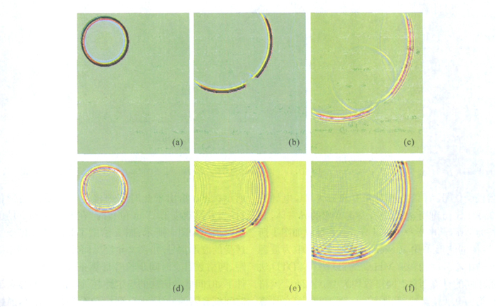
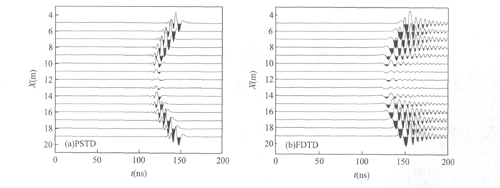
In order to improve the resolution of crosshole electromagnetic tomography, high precision of forward modeling is necessary. A pseudo-spectral time domain (PSTD) forward modeling was used to simulate electromagnetic wave propagation between two boreholes. The PSTD algorithm is based on finite difference time domain (FDTD) method and employs fast Fourier transform (FFT) to calculate spatial derivatives in Maxwell′s equations. Besides having the strongpoints of FDTD method, PSTD algorithm also demonstrates higher calculation precision than FDTD method under the same calculation condition. The PSTD forward modeling has laid important foundation of crosshole electromagnetic high-resolution tomography.
In order to improve the resolution of crosshole electromagnetic tomography, high precision of forward modeling is necessary. A pseudo-spectral time domain (PSTD) forward modeling was used to simulate electromagnetic wave propagation between two boreholes. The PSTD algorithm is based on finite difference time domain (FDTD) method and employs fast Fourier transform (FFT) to calculate spatial derivatives in Maxwell′s equations. Besides having the strongpoints of FDTD method, PSTD algorithm also demonstrates higher calculation precision than FDTD method under the same calculation condition. The PSTD forward modeling has laid important foundation of crosshole electromagnetic high-resolution tomography.


2007, 32(4): 474-480.
Abstract:
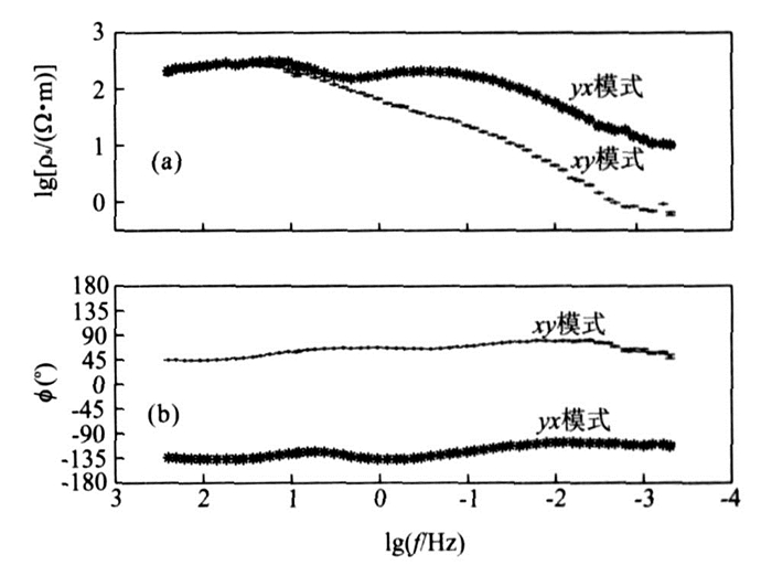
The research of magnetotelluric (MT) on the profile along Zhada-Quanshuihu on the west of the Tibetan plateau shows that the area is divided into three structural parts by Yalung Tsangpo suture and Bangong-Nujiang suture. From south to north they are Himalaya terrane, Gandese terrane and Qiangtang terrane. The area is widely distributed with high conductive layers, with fluctuating tops. The high conductive layer of Gandese terrane is deeper while that of Qiangtang terrane and Himalaya terrane is shallower. And the deepest high conductive layer is along the south of Bangong-Nujiang suture. The top surface of high conductive layer in the south Bangong-Nujiang suture is at the depth of about 20 km, which is lower than that in north of Bangong-Nujiang suture. The high conductive layer inside Gandese terrane extends northward and in the southern Qiangtang there exist double high conductive layers. In the upper crust along the profile there are groups of lateral electrical gradient zones or distortion zones of different scale and attitude, indicating the distribution of faults and sutures along the profile. According to the character of electrical structure, the structural characteristic and spatial distribution of Yalung Tsangpo suture, Bangong-Nujiang suture and the major faults of Longmucuo and Ger-Zangbo were inferred.
The research of magnetotelluric (MT) on the profile along Zhada-Quanshuihu on the west of the Tibetan plateau shows that the area is divided into three structural parts by Yalung Tsangpo suture and Bangong-Nujiang suture. From south to north they are Himalaya terrane, Gandese terrane and Qiangtang terrane. The area is widely distributed with high conductive layers, with fluctuating tops. The high conductive layer of Gandese terrane is deeper while that of Qiangtang terrane and Himalaya terrane is shallower. And the deepest high conductive layer is along the south of Bangong-Nujiang suture. The top surface of high conductive layer in the south Bangong-Nujiang suture is at the depth of about 20 km, which is lower than that in north of Bangong-Nujiang suture. The high conductive layer inside Gandese terrane extends northward and in the southern Qiangtang there exist double high conductive layers. In the upper crust along the profile there are groups of lateral electrical gradient zones or distortion zones of different scale and attitude, indicating the distribution of faults and sutures along the profile. According to the character of electrical structure, the structural characteristic and spatial distribution of Yalung Tsangpo suture, Bangong-Nujiang suture and the major faults of Longmucuo and Ger-Zangbo were inferred.


2007, 32(4): 481-486.
Abstract:
The offset-domain prestack depth migration with optimal separable approximation, based on the double square root equation, is applied to image complex media with large and rapid velocity variations. The method downward continues the source and the receiver wavefields simultaneously. The mixed domain algorithm with forward Fourier and inverse Fourier transform is used to construct the double square root equation wavefield extrapolation operator. This operator separates variables in the wave number domain and variables in the space domain. The phase operation is implemented in the wave number domain, while the time delay for lateral velocity variation is corrected in the space domain. The migration algorithm is efficient for the seismic data and it is not computed shot by shot. The data set test of the Marmousi model indicates that the offset-domain migration provides a satisfactory seismic migration section on which complex geologic structures are imaged in media with large and rapid lateral velocity variations.
The offset-domain prestack depth migration with optimal separable approximation, based on the double square root equation, is applied to image complex media with large and rapid velocity variations. The method downward continues the source and the receiver wavefields simultaneously. The mixed domain algorithm with forward Fourier and inverse Fourier transform is used to construct the double square root equation wavefield extrapolation operator. This operator separates variables in the wave number domain and variables in the space domain. The phase operation is implemented in the wave number domain, while the time delay for lateral velocity variation is corrected in the space domain. The migration algorithm is efficient for the seismic data and it is not computed shot by shot. The data set test of the Marmousi model indicates that the offset-domain migration provides a satisfactory seismic migration section on which complex geologic structures are imaged in media with large and rapid lateral velocity variations.


2007, 32(4): 487-490.
Abstract:
Under the constraint of the surface structure investigation data and by using refraction static correction method on seismic reflection records, we can invert accurate and reasonable surface structure model, and furthermore, calculate shot and receiver static correction values. We select survey line 04314 of Beijixing area in Qaidam basin to construct seismic numerical modeling, and do seismic processing by using several different static correction methods to deal with the model data and the corresponding raw seismic data. The result is that the error of the comprehensive refraction static correction method is minimal and its overlay effect is the best. The comprehensive refraction static correction method combines the advantages of the model static correction method and the refraction static correction method. It not only solves the short wavelength static correction problem that affects the section signal-to-noise ratio, but also solves the long wavelength static correction problem that generates fictitious structures.
Under the constraint of the surface structure investigation data and by using refraction static correction method on seismic reflection records, we can invert accurate and reasonable surface structure model, and furthermore, calculate shot and receiver static correction values. We select survey line 04314 of Beijixing area in Qaidam basin to construct seismic numerical modeling, and do seismic processing by using several different static correction methods to deal with the model data and the corresponding raw seismic data. The result is that the error of the comprehensive refraction static correction method is minimal and its overlay effect is the best. The comprehensive refraction static correction method combines the advantages of the model static correction method and the refraction static correction method. It not only solves the short wavelength static correction problem that affects the section signal-to-noise ratio, but also solves the long wavelength static correction problem that generates fictitious structures.


Research of Conductive Structure of Crust and Upper Mantle beneath the South-Central Tibetan Plateau
2007, 32(4): 491-498.
Abstract:
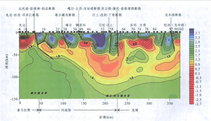
With super-wide band magnetotelluric sounding data of Jilong-Cuoqin profile (named line 800) finished at 2001 and funded by the Ministry of Land and Resources, and Dingri-Cuomai profile (named line 900) finished at 2004 and funded by Ministry of Education, we obtained the strike direction of each MT station through strike analysis, then traced profiles perpendicular to the main strike direction, and finally got the resistivity model of each profile by Nonlinear Conjugate Gradients (NLCG) Inversion. With these two models, we have described resistivity structure features of the crust and upper mantle of the center-southern Tibetan plateau and their relationship with Yaluzangbo Suture: the upper crust of the research area is a resistive layer whose resistivity value ranges from 200 to 3 000 Ω·m; the depth of its bottom surface is about 15-20 km in general, but the bottom surface of the resistive layer is deeper in the middle of these two profiles; at line 900 it is about 30 km deep and even at line 800 it is about 38 km deep. There is a gradient belt of resistivity at the depth of 15-45 km, with a conductive layer beneath it whose resistivity is even less than 5 Ω·m. This conductive layer is composed of individual conductive bodies. At the south of Yaluzangbo suture the conductive bodies are smaller, with the thickness of about 10 km, leaning slightly to the north, but at the north of Yaluzangbo suture the conductive bodies are bigger, with the thickness of about 30 km, leaning slightly to the north too. Relatively speaking, the conductive bodies of line 900 are thinner than those of line 800, and the bottom surface of line 900 is also at a shallower depth. At last, after analyzing the factors affecting the resistivity of rocks, we concluded that the formation of the high-conductive layer was attributed to the partial melt of rocks or hydrous fluid in them. It suggests that middle and lower crust of the center-southern Tibetan plateau is very thick and hot, flabby and waxy.
With super-wide band magnetotelluric sounding data of Jilong-Cuoqin profile (named line 800) finished at 2001 and funded by the Ministry of Land and Resources, and Dingri-Cuomai profile (named line 900) finished at 2004 and funded by Ministry of Education, we obtained the strike direction of each MT station through strike analysis, then traced profiles perpendicular to the main strike direction, and finally got the resistivity model of each profile by Nonlinear Conjugate Gradients (NLCG) Inversion. With these two models, we have described resistivity structure features of the crust and upper mantle of the center-southern Tibetan plateau and their relationship with Yaluzangbo Suture: the upper crust of the research area is a resistive layer whose resistivity value ranges from 200 to 3 000 Ω·m; the depth of its bottom surface is about 15-20 km in general, but the bottom surface of the resistive layer is deeper in the middle of these two profiles; at line 900 it is about 30 km deep and even at line 800 it is about 38 km deep. There is a gradient belt of resistivity at the depth of 15-45 km, with a conductive layer beneath it whose resistivity is even less than 5 Ω·m. This conductive layer is composed of individual conductive bodies. At the south of Yaluzangbo suture the conductive bodies are smaller, with the thickness of about 10 km, leaning slightly to the north, but at the north of Yaluzangbo suture the conductive bodies are bigger, with the thickness of about 30 km, leaning slightly to the north too. Relatively speaking, the conductive bodies of line 900 are thinner than those of line 800, and the bottom surface of line 900 is also at a shallower depth. At last, after analyzing the factors affecting the resistivity of rocks, we concluded that the formation of the high-conductive layer was attributed to the partial melt of rocks or hydrous fluid in them. It suggests that middle and lower crust of the center-southern Tibetan plateau is very thick and hot, flabby and waxy.

2007, 32(4): 499-503.
Abstract:
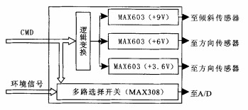
Seafloor magnetolluric detection is greatly influenced by environmental factor, which is different from onshore similar survey technology. To get the genuine seafloor rock medium electrical model, data processing about seafloor magnetolluric raw signal requires information such as seafloor instrument bearing orientation, obliquity, and temperature, by which the real vector change bearing of seafloor magnetolluric fields can be acquired, and then the uniform explanation about the whole survey of multi-station is obtained. To achieve this objective, the seafloor magnetolluric instrument must be equipped with the environmental parameter acquisition channel. The channel acquires many environmental parameters time-sharing circularly, such as orientation, obliquity, temperature and so on; the circuit consists of embedded computer PC104, multiplexers, logical control gate array and other hardware units. After completing the whole hardware architecture, the circuit driver is developed to record and save seafloor environmental parameters in real-time mode. Ocean recent test results indicate that the circuit hardware and driver software have been developed to meet the design requirements.
Seafloor magnetolluric detection is greatly influenced by environmental factor, which is different from onshore similar survey technology. To get the genuine seafloor rock medium electrical model, data processing about seafloor magnetolluric raw signal requires information such as seafloor instrument bearing orientation, obliquity, and temperature, by which the real vector change bearing of seafloor magnetolluric fields can be acquired, and then the uniform explanation about the whole survey of multi-station is obtained. To achieve this objective, the seafloor magnetolluric instrument must be equipped with the environmental parameter acquisition channel. The channel acquires many environmental parameters time-sharing circularly, such as orientation, obliquity, temperature and so on; the circuit consists of embedded computer PC104, multiplexers, logical control gate array and other hardware units. After completing the whole hardware architecture, the circuit driver is developed to record and save seafloor environmental parameters in real-time mode. Ocean recent test results indicate that the circuit hardware and driver software have been developed to meet the design requirements.

2007, 32(4): 504-510.
Abstract:
Eclogite, one of the important lithologies in the main hole of Chinese Continental Scientific Drilling (CCSD) Project, is distributed over 3 245 m above the sea-level. Gamma-ray, compensating density and neutron well-logging and so on can be used to distinguish the ecolgite from others in the main hole. In the paper, because of diverse mineral and chemical components and well-logging responses, eclogites are classified in terms of three aspects: origin, content of oxids and sub-minerals. The studied statistical method in the paper is used to evaluate 11 kinds of reconstructed eclogites. As a result, eclogites can be divided into 6 types by using of well logs. With the identification of these six types in the main hole, 20 sections of eclogites are sorted and analyzed, which will provide important information for geological research of CCSD.
Eclogite, one of the important lithologies in the main hole of Chinese Continental Scientific Drilling (CCSD) Project, is distributed over 3 245 m above the sea-level. Gamma-ray, compensating density and neutron well-logging and so on can be used to distinguish the ecolgite from others in the main hole. In the paper, because of diverse mineral and chemical components and well-logging responses, eclogites are classified in terms of three aspects: origin, content of oxids and sub-minerals. The studied statistical method in the paper is used to evaluate 11 kinds of reconstructed eclogites. As a result, eclogites can be divided into 6 types by using of well logs. With the identification of these six types in the main hole, 20 sections of eclogites are sorted and analyzed, which will provide important information for geological research of CCSD.


2007, 32(4): 511-516.
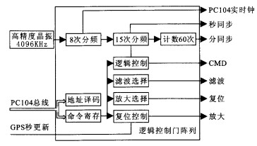
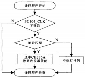
Abstract:
The marine environment is complex. Both the overseas literatures and the domestic applications indicate that when the detecting device is working on the seafloor, losing the data occasionally happens because of various unexpected factors. Compared with continental operation, there are higher risk and expenses in detecting and more difficult in acquisition repeatedly on the marine magnetotellurics. Therefore, it is of great scientific significance to study the technique prospecting doubly and simultaneously so as to extract the whole medium electric information in exploration areas and ensure the integrality of the real acquisition data. The project chooses the PC104 computer as microcontroller and also comprises of the interface circuit, which converts the PC104 bus to the USB bus and saves the real time data acquired on the marine magnetotellurics into the IDE disk and U disk simultaneously. The chips adopted by the circuit include CPLD in encoding and logic controlling, bidirectional data received and transmitted and CH375A of interface conversion, and the source program of PC104 also contains their corresponding instructions. With that function, it has insured the full preservation of the acquisition because of redundant data. The practicality has been approved by Huanghai Sea experimentation.
The marine environment is complex. Both the overseas literatures and the domestic applications indicate that when the detecting device is working on the seafloor, losing the data occasionally happens because of various unexpected factors. Compared with continental operation, there are higher risk and expenses in detecting and more difficult in acquisition repeatedly on the marine magnetotellurics. Therefore, it is of great scientific significance to study the technique prospecting doubly and simultaneously so as to extract the whole medium electric information in exploration areas and ensure the integrality of the real acquisition data. The project chooses the PC104 computer as microcontroller and also comprises of the interface circuit, which converts the PC104 bus to the USB bus and saves the real time data acquired on the marine magnetotellurics into the IDE disk and U disk simultaneously. The chips adopted by the circuit include CPLD in encoding and logic controlling, bidirectional data received and transmitted and CH375A of interface conversion, and the source program of PC104 also contains their corresponding instructions. With that function, it has insured the full preservation of the acquisition because of redundant data. The practicality has been approved by Huanghai Sea experimentation.


2007, 32(4): 517-522.
Abstract:
Based on the improved analytical expression for computing the gravity anomalies due to a homogeneous polyhedral body composed of polygonal facets, and by applying the forward theory with the coordinate transformation of vector and tensor, we deduced the analytical expressions for both gravity gradient tensor and magnetic anomalies due to a polygon, and obtained new analytical expressions for computing vertical gradient of gravity anomalies and vertical component of magnetic anomalies due to a polyhedral body. And we also explicitly developed the complete and unified expressions for calculating gravity anomalies, gravity gradient and magnetic anomalies due to the homogeneous polyhedra. Furthermore, we deduced new analytical expressions for computing the vertical gradient of gravity anomalies due to a finite rectangular prism by applying the new obtained expressions for gravity gradient tensor due to a polyhedral target body. Comparison with forward calculation of models testified the correctness of these new expressions. It will reduce forward time of gravimagnetic anomaly and improve computational efficiency by applying our unified expressions for joint forward of gravimagnetic anomalies due to homogeneous polyhedral bodies.
Based on the improved analytical expression for computing the gravity anomalies due to a homogeneous polyhedral body composed of polygonal facets, and by applying the forward theory with the coordinate transformation of vector and tensor, we deduced the analytical expressions for both gravity gradient tensor and magnetic anomalies due to a polygon, and obtained new analytical expressions for computing vertical gradient of gravity anomalies and vertical component of magnetic anomalies due to a polyhedral body. And we also explicitly developed the complete and unified expressions for calculating gravity anomalies, gravity gradient and magnetic anomalies due to the homogeneous polyhedra. Furthermore, we deduced new analytical expressions for computing the vertical gradient of gravity anomalies due to a finite rectangular prism by applying the new obtained expressions for gravity gradient tensor due to a polyhedral target body. Comparison with forward calculation of models testified the correctness of these new expressions. It will reduce forward time of gravimagnetic anomaly and improve computational efficiency by applying our unified expressions for joint forward of gravimagnetic anomalies due to homogeneous polyhedral bodies.


2007, 32(4): 523-527.
Abstract:
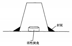
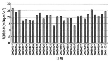
We designed and developed an activated charcoal cumulated adsorption method for measuring radon exhalation rate from soil to perform rapid observation at many sites in a large area. Based on the data of measurements on the radon exhalation facility and real-time soil radon exhalation rate in the field, we studied the types of the activated charcoal and sampling device, accumulated exposure time and radon effective decay constant. We investigated the soil radon exhalation in a university yard (sandy loam) from 2002-2003. The average of radon exhalation rate is 20.15 mBq·m-2·s-1; the standard deviation is 3.55 mBq·m-2·s-1, and the variety ranges from 13.49 to 26.75 mBq·m-2·s-1. By comparison, the results of activated charcoal absorption and an equipment of electrostatic collection are coincident with each other. The results revealed that the method of activated charcoal absorption is practical, feasible and rapid for measuring the 222Rn exhalation rate from soil in the field.
We designed and developed an activated charcoal cumulated adsorption method for measuring radon exhalation rate from soil to perform rapid observation at many sites in a large area. Based on the data of measurements on the radon exhalation facility and real-time soil radon exhalation rate in the field, we studied the types of the activated charcoal and sampling device, accumulated exposure time and radon effective decay constant. We investigated the soil radon exhalation in a university yard (sandy loam) from 2002-2003. The average of radon exhalation rate is 20.15 mBq·m-2·s-1; the standard deviation is 3.55 mBq·m-2·s-1, and the variety ranges from 13.49 to 26.75 mBq·m-2·s-1. By comparison, the results of activated charcoal absorption and an equipment of electrostatic collection are coincident with each other. The results revealed that the method of activated charcoal absorption is practical, feasible and rapid for measuring the 222Rn exhalation rate from soil in the field.

2007, 32(4): 528-532.
Abstract:
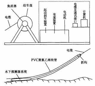
In order to speed up the marine mineral exploration of China, the first sea-bed towed gamma-ray spectrometer was developed and it was tested in Bohai Ocean for oil exploration for the first time. The results show that the concentration of 238U, 232Th, 40K of rocks and unconsolidated sediments on the sea floor can be acquired in-site. There is a relative low abnormity in the known oil field. It is a rapid and cheap in-site method to explore the marine resource.
In order to speed up the marine mineral exploration of China, the first sea-bed towed gamma-ray spectrometer was developed and it was tested in Bohai Ocean for oil exploration for the first time. The results show that the concentration of 238U, 232Th, 40K of rocks and unconsolidated sediments on the sea floor can be acquired in-site. There is a relative low abnormity in the known oil field. It is a rapid and cheap in-site method to explore the marine resource.


2007, 32(4): 533-539.
Abstract:
In this paper, a pilot study of paleomagnetism and rock magnetism is done on 55 eclogite samples collected from Maobei area, Donghai County, Jiangsu Province. Synchronously, some of the samples are analyzed by electron-probe and scanning electric microscope, and tested for the isothermal remanence, hysteresis loop, magnetic fabric, thermal magnetic properties. The result indicates that there are two groups of stable remanence, i. e- the normal polarity and reversed polarity. The remanence orientations are: D=94. 3°, I=-29. 1° and D=273. 7°, I=15. 4° respectively. The magnetization and the density of the samples with normal polarities are very different from that of the samples with reversed polarities. The magnetic anisotropy is weak, and the minimum axis is hardly confirmed. The isothermal remanence and the hysteresis loop show that the magnetic carriers of the eclogite may be SD (single domain) and PSI) (pseudo-single domain) magnetite. According to the magnetic property, the cause of the formation of magnetic carrier, the causation of the remanence, and the significance for the geotectonic are discussed at the end of the paper.
In this paper, a pilot study of paleomagnetism and rock magnetism is done on 55 eclogite samples collected from Maobei area, Donghai County, Jiangsu Province. Synchronously, some of the samples are analyzed by electron-probe and scanning electric microscope, and tested for the isothermal remanence, hysteresis loop, magnetic fabric, thermal magnetic properties. The result indicates that there are two groups of stable remanence, i. e- the normal polarity and reversed polarity. The remanence orientations are: D=94. 3°, I=-29. 1° and D=273. 7°, I=15. 4° respectively. The magnetization and the density of the samples with normal polarities are very different from that of the samples with reversed polarities. The magnetic anisotropy is weak, and the minimum axis is hardly confirmed. The isothermal remanence and the hysteresis loop show that the magnetic carriers of the eclogite may be SD (single domain) and PSI) (pseudo-single domain) magnetite. According to the magnetic property, the cause of the formation of magnetic carrier, the causation of the remanence, and the significance for the geotectonic are discussed at the end of the paper.


2007, 32(4): 540-544.
Abstract:
Building the Pingtan Strait bridge in Fujian Province, with a span of 3 478 m, is a very large project. Due to the bad natural conditions and insufficient investment capital, the engineering problems are very complex. According to the vibrating impact-model source, reflection seismic exploration was conducted to investigate the strata configuration and the geological conditions. At the same time, the evaluation was made of the geological engineering conditions for building the bridge.
Building the Pingtan Strait bridge in Fujian Province, with a span of 3 478 m, is a very large project. Due to the bad natural conditions and insufficient investment capital, the engineering problems are very complex. According to the vibrating impact-model source, reflection seismic exploration was conducted to investigate the strata configuration and the geological conditions. At the same time, the evaluation was made of the geological engineering conditions for building the bridge.


2007, 32(4): 545-548.
Abstract:
Seismic skeletonization is a pattern recognition method that is used to automatically track seismic events and produce an automatic line drawing. By using this method, the cycles in every seismic trace are first detected and the attributes of cycles are characterized. Then the seismic events are tracked based on the minimum of cost function of cycle correlation in three neighbor traces, and the attributes of events are characterized, and the attributes are kept track of in a catalog, according to which, one can perform attribute-based analysis and data filtering and quantitatively interpretation. In this paper, the previous seismic skeletonization is modified and simplified and an quick automatic tracking of events and line drawing can be realized. The experiments on the synthetic data and the raw data show that the modified method is more efficient facilitates the calculation.
Seismic skeletonization is a pattern recognition method that is used to automatically track seismic events and produce an automatic line drawing. By using this method, the cycles in every seismic trace are first detected and the attributes of cycles are characterized. Then the seismic events are tracked based on the minimum of cost function of cycle correlation in three neighbor traces, and the attributes of events are characterized, and the attributes are kept track of in a catalog, according to which, one can perform attribute-based analysis and data filtering and quantitatively interpretation. In this paper, the previous seismic skeletonization is modified and simplified and an quick automatic tracking of events and line drawing can be realized. The experiments on the synthetic data and the raw data show that the modified method is more efficient facilitates the calculation.


2007, 32(4): 549-553.
Abstract:
In the seismic model and forward, building complex 2D and 3D seismic models by making use of the known or virtual information is of great importance to the subsequent seismic modeling, binning analysis and rational design of geometry system. It also offers a tool for the interpretation of seismic data processing and provides the necessary infrastructure for inversion methods. This paper briefly describes some algorithms of building the seismic model and computer visualization according to the feature of seismic model. It mainly analyzes the algorithms of building 3D seismic model opern in computer visualization, such as Kriging Iterpolation and Delaunay Triangulation. According to the model-building data from the above algorithms, 3D seismic model can be built in "seismic model and forward" of SeisWay1.0 by means of blocks section modeling.
In the seismic model and forward, building complex 2D and 3D seismic models by making use of the known or virtual information is of great importance to the subsequent seismic modeling, binning analysis and rational design of geometry system. It also offers a tool for the interpretation of seismic data processing and provides the necessary infrastructure for inversion methods. This paper briefly describes some algorithms of building the seismic model and computer visualization according to the feature of seismic model. It mainly analyzes the algorithms of building 3D seismic model opern in computer visualization, such as Kriging Iterpolation and Delaunay Triangulation. According to the model-building data from the above algorithms, 3D seismic model can be built in "seismic model and forward" of SeisWay1.0 by means of blocks section modeling.


2007, 32(4): 554-558.
Abstract:
According to the special geological conditions at Damintun sag in Liaohe basin, such as complex structures and rapid lateral change of thin and interbedded reservoirs, the technique of logging constrained seismic inversion based on pre-stack high-resolution seismic data was used to describe oil-gas reservoirs. In combination with lithologic interpretation, reservoir seismic inversion can effectively identify underground complex geologic structures and seismic anomalous reflection volume and quantitatively predict the distribution of sandstones in space and the law of their variation. The paper studies the method for reservoir prediction by using logging-restrained inversion technique based on the restriction of geological conditions and log to find out the rule of reservoir distribution in this region and fix prospective lithologic traps. And we have obtained satisfactory results in the exploration and development of the oilfield.
According to the special geological conditions at Damintun sag in Liaohe basin, such as complex structures and rapid lateral change of thin and interbedded reservoirs, the technique of logging constrained seismic inversion based on pre-stack high-resolution seismic data was used to describe oil-gas reservoirs. In combination with lithologic interpretation, reservoir seismic inversion can effectively identify underground complex geologic structures and seismic anomalous reflection volume and quantitatively predict the distribution of sandstones in space and the law of their variation. The paper studies the method for reservoir prediction by using logging-restrained inversion technique based on the restriction of geological conditions and log to find out the rule of reservoir distribution in this region and fix prospective lithologic traps. And we have obtained satisfactory results in the exploration and development of the oilfield.


2007, 32(4): 559-563.
Abstract:
Aimed at solving the complicated geological problem of Daye iron deposit in Hubei Province, this paper applies the techniques of probability analysis and physical property inversion to realize fine processing and interpreting of high-precision 3D gravity and magnetic data in the Daye iron deposit, and proposes a significant reference for the prospecting in the deep and surrounding of mines. We inverted the strong aeromagnetic anomaly with 3D probability tomography under no-constraints, completed 3D magnetic interactive inversion with the help of topography and other prior geological information, and forecasted the space extended state for the contact zone of sedimentary rock and diorite in the mining areas. Then we inverted 3D physical property characters within a fixed quantity in the areas. The inverse results show that the significant prospecting zones are distributed in the deep (under 1 000 m) and the flexures of the contact zones in the mining areas. These predicted zones had been proved by the practical logging.
Aimed at solving the complicated geological problem of Daye iron deposit in Hubei Province, this paper applies the techniques of probability analysis and physical property inversion to realize fine processing and interpreting of high-precision 3D gravity and magnetic data in the Daye iron deposit, and proposes a significant reference for the prospecting in the deep and surrounding of mines. We inverted the strong aeromagnetic anomaly with 3D probability tomography under no-constraints, completed 3D magnetic interactive inversion with the help of topography and other prior geological information, and forecasted the space extended state for the contact zone of sedimentary rock and diorite in the mining areas. Then we inverted 3D physical property characters within a fixed quantity in the areas. The inverse results show that the significant prospecting zones are distributed in the deep (under 1 000 m) and the flexures of the contact zones in the mining areas. These predicted zones had been proved by the practical logging.


2007, 32(4): 564-568.
Abstract:
How to confirm the decomposition level is a basic issue in wavelet multi-resolution analysis for gravity anomalies. In this paper, the relations between the decomposition level and the length of signal, and the relations between the decomposition level and the support width of mother wavelets are discussed. Based on the comparison between the result of wavelet multi-resolution analysis for Bouger gravity anomalies in Tarim basin and Tianshan orogenic belt and the fearures of corresponding geoid anomaly, the authors proposed a method for confirming the decomposition level. Using bior3.5 wavelet, the 5th level detail can avoid the interference of wavelet generating functions and thereby its result accords with the features of corresponding geoid anomaly. However, there are many differences between the 6th and its corresponding geoid anomaly. Therefore, in terms of signal processing and geophysics theory, the proper decomposition level is 5, and any higher-level decomposition is unreasonable. All these researches have contributed a lot to confirming the decomposition level in processing gravity anomalies by providing effective and feasible methods.
How to confirm the decomposition level is a basic issue in wavelet multi-resolution analysis for gravity anomalies. In this paper, the relations between the decomposition level and the length of signal, and the relations between the decomposition level and the support width of mother wavelets are discussed. Based on the comparison between the result of wavelet multi-resolution analysis for Bouger gravity anomalies in Tarim basin and Tianshan orogenic belt and the fearures of corresponding geoid anomaly, the authors proposed a method for confirming the decomposition level. Using bior3.5 wavelet, the 5th level detail can avoid the interference of wavelet generating functions and thereby its result accords with the features of corresponding geoid anomaly. However, there are many differences between the 6th and its corresponding geoid anomaly. Therefore, in terms of signal processing and geophysics theory, the proper decomposition level is 5, and any higher-level decomposition is unreasonable. All these researches have contributed a lot to confirming the decomposition level in processing gravity anomalies by providing effective and feasible methods.

2007, 32(4): 569-574.
Abstract:
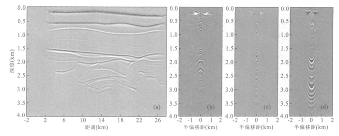
Wave equation prestack depth migration based on wavefield depth recursive extrapolation can hardly give out a common image gather in offset domain as accurately as Kirchhoff integral based prestack depth migration does. In order to make up for this defect, we have analyzed various methods of wave equation migration common image gather. And by using the single square root operator for wavefield extrapolation and the windowed Fourier frame expansion and reconstruction of wavefield, a method for local angle domain common image gather is proposed, i.e. common image gather in reflection angle domain of imaging point. The application of the angle domain common image gather in Marmousi model data and a two dimensional real seismic data yields ideal results. The angle domain common image gather method for wave equation derived in this paper will provide a foundation for further migration velocity analysis and amplitude versus angle analysis of migrated data.
Wave equation prestack depth migration based on wavefield depth recursive extrapolation can hardly give out a common image gather in offset domain as accurately as Kirchhoff integral based prestack depth migration does. In order to make up for this defect, we have analyzed various methods of wave equation migration common image gather. And by using the single square root operator for wavefield extrapolation and the windowed Fourier frame expansion and reconstruction of wavefield, a method for local angle domain common image gather is proposed, i.e. common image gather in reflection angle domain of imaging point. The application of the angle domain common image gather in Marmousi model data and a two dimensional real seismic data yields ideal results. The angle domain common image gather method for wave equation derived in this paper will provide a foundation for further migration velocity analysis and amplitude versus angle analysis of migrated data.


2007, 32(4): 575-582.
Abstract:
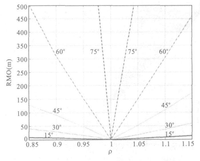
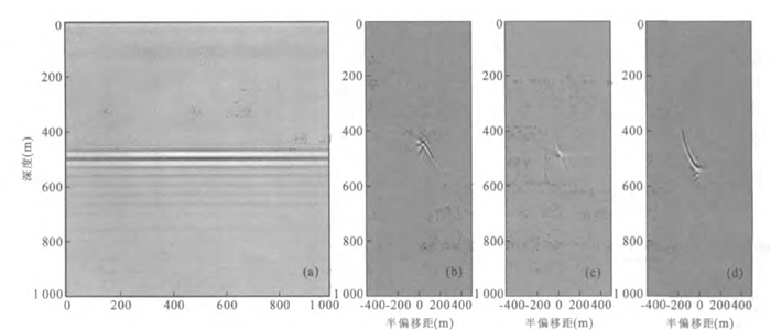
In order to probe the relationships between wave equation offset domain common image gathers (ODCIGs) /angle domain common image gathers (ADCIGs) with migration velocity, we quantitatively derive the changes of ODCIGs and ADCIGs along with migration velocity on the assumption of uniform velocity medium with a horizontal reflector. We come to conclusion that ODCIGs are hyperbolas with half offset; on the contrary, they are ellipses. Combined with the results of depth focusing analysis, we find the apparent incident angles in ADCIGs are larger than the real incident angles when the migration velocity is larger than the true one and vice versa. With lower migration velocity, the residual moveout (RMO) on ADCIGs is an ellipse with the tangent of apparent incident angle; otherwise, it′s a hyperbola. In the valid seismic incident angle, ADCIGs are much more sensitive to the higher migration velocity. As to migration velocity analysis (MVA), it is suggested to start with a little higher initial velocity.
In order to probe the relationships between wave equation offset domain common image gathers (ODCIGs) /angle domain common image gathers (ADCIGs) with migration velocity, we quantitatively derive the changes of ODCIGs and ADCIGs along with migration velocity on the assumption of uniform velocity medium with a horizontal reflector. We come to conclusion that ODCIGs are hyperbolas with half offset; on the contrary, they are ellipses. Combined with the results of depth focusing analysis, we find the apparent incident angles in ADCIGs are larger than the real incident angles when the migration velocity is larger than the true one and vice versa. With lower migration velocity, the residual moveout (RMO) on ADCIGs is an ellipse with the tangent of apparent incident angle; otherwise, it′s a hyperbola. In the valid seismic incident angle, ADCIGs are much more sensitive to the higher migration velocity. As to migration velocity analysis (MVA), it is suggested to start with a little higher initial velocity.