


2008 Vol. 33, No. 5
Display Method:
 PDF 69KB
2008, 33(5): 577-590.
Abstract:
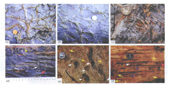
The Mesoproterozoic Chuanlinggou Formation (ca. 1.7Ga) consists of up to 900m thick, dark-gray to black shale and fine-grained sandstone that are widespread in the North China platform. Abundant centimeter-scale sand veins are present within the black shale layers of this unit, particularly in the central part. Sand veins display ptygmatic shapes, perpendicular or with a high angle to sedimentary bedding. They penetrate the black shale layers but are vertically discontinuous and often terminated by thin, lenticular sandstone beds, forming small-scale 'tepee-like' structures. On bedding planes, sand veins are expressed as small sand ridges with 1-3mm positive relief. Lack of polygonal shapes and their occurrence in thinly laminated, deep-water shale prevent an origin from sand-filled desiccation cracks. Instead, their close association with microbially induced sedimentary structures (MISS), such as micro-wrinkles and gas blisters, and putative bacteria fossils (possibly coccoidal cyanobacteria) and framboidal pyrites, suggests that they were formed by degassing of methane from microbial mat decay. Methane gas disrupted overlying sedimentary layers, creating fractures open to seawater. Fine-grained quartz sands, which were transported into the depositional environment by storm events, filled the open fractures. Sand-filled fractures were shortened and deformed during burial compaction, forming ptygmatic shapes. The presence of dispersed dolomite and siderite in these sand veins suggests authigenic carbonate precipitation from anaerobic oxidation of methane (AOM). Sand veins are mainly distributed within the Chuanlinggou Formation and are spatially widespread in the North China platform. If their methane origin is confirmed, they may have important implications for the Mesoproterozoic plaeoclimate. With a low seawater sulfate concentration during the Mesoproterozoic, methane release from microbial mat decay and/or microbial methanogenesis during shallow burial may have been proportionally higher than that of the modern marine environments, with resultant increase in the relative importance of methane in maintaining the Mesoproterozoic greenhouse climate.
The Mesoproterozoic Chuanlinggou Formation (ca. 1.7Ga) consists of up to 900m thick, dark-gray to black shale and fine-grained sandstone that are widespread in the North China platform. Abundant centimeter-scale sand veins are present within the black shale layers of this unit, particularly in the central part. Sand veins display ptygmatic shapes, perpendicular or with a high angle to sedimentary bedding. They penetrate the black shale layers but are vertically discontinuous and often terminated by thin, lenticular sandstone beds, forming small-scale 'tepee-like' structures. On bedding planes, sand veins are expressed as small sand ridges with 1-3mm positive relief. Lack of polygonal shapes and their occurrence in thinly laminated, deep-water shale prevent an origin from sand-filled desiccation cracks. Instead, their close association with microbially induced sedimentary structures (MISS), such as micro-wrinkles and gas blisters, and putative bacteria fossils (possibly coccoidal cyanobacteria) and framboidal pyrites, suggests that they were formed by degassing of methane from microbial mat decay. Methane gas disrupted overlying sedimentary layers, creating fractures open to seawater. Fine-grained quartz sands, which were transported into the depositional environment by storm events, filled the open fractures. Sand-filled fractures were shortened and deformed during burial compaction, forming ptygmatic shapes. The presence of dispersed dolomite and siderite in these sand veins suggests authigenic carbonate precipitation from anaerobic oxidation of methane (AOM). Sand veins are mainly distributed within the Chuanlinggou Formation and are spatially widespread in the North China platform. If their methane origin is confirmed, they may have important implications for the Mesoproterozoic plaeoclimate. With a low seawater sulfate concentration during the Mesoproterozoic, methane release from microbial mat decay and/or microbial methanogenesis during shallow burial may have been proportionally higher than that of the modern marine environments, with resultant increase in the relative importance of methane in maintaining the Mesoproterozoic greenhouse climate.


2008, 33(5): 591-602.
Abstract:
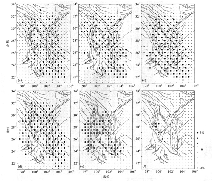
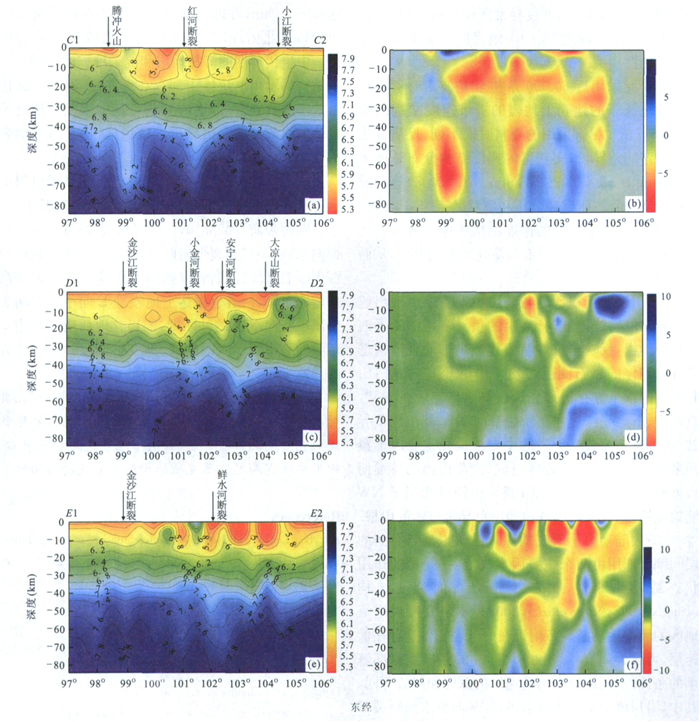
We have selected about 60000 arrival times recorded by 205 regional stations, with the seismic tomography theory and three dimensional ray tracing method, to determine a detailed three-dimensional (3-D) P wave velocity structure of the lithosphere in southwest China. Then we present the medium structure and tectonic characteristics of different depth which are reflected by the 3-D P wave velocity image in this area, integrated with the previous geological features and geophysical data. The results suggest that deposit basins and alpine mountainous regions present as negative anomaly, with some montage negative anomalies even extending to the deep crust or the upper mantle, which reflects the sharp rising of the new orogens and the concomitant gravity equilibrium; low-velocity layers exist far and wide in the middle and deep crust under the large fault zones around the Sichuan-Yunnan block, which can be taken as the decoupling layer adjusting the faults and blocks movement; some deep structures related with the main active faults, and the trends and extending depths can be distinguished from the P wave velocity image.
We have selected about 60000 arrival times recorded by 205 regional stations, with the seismic tomography theory and three dimensional ray tracing method, to determine a detailed three-dimensional (3-D) P wave velocity structure of the lithosphere in southwest China. Then we present the medium structure and tectonic characteristics of different depth which are reflected by the 3-D P wave velocity image in this area, integrated with the previous geological features and geophysical data. The results suggest that deposit basins and alpine mountainous regions present as negative anomaly, with some montage negative anomalies even extending to the deep crust or the upper mantle, which reflects the sharp rising of the new orogens and the concomitant gravity equilibrium; low-velocity layers exist far and wide in the middle and deep crust under the large fault zones around the Sichuan-Yunnan block, which can be taken as the decoupling layer adjusting the faults and blocks movement; some deep structures related with the main active faults, and the trends and extending depths can be distinguished from the P wave velocity image.


2008, 33(5): 603-617.
Abstract:
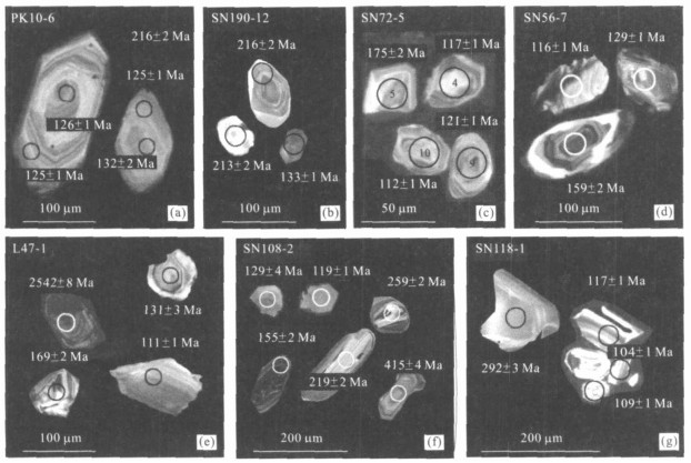
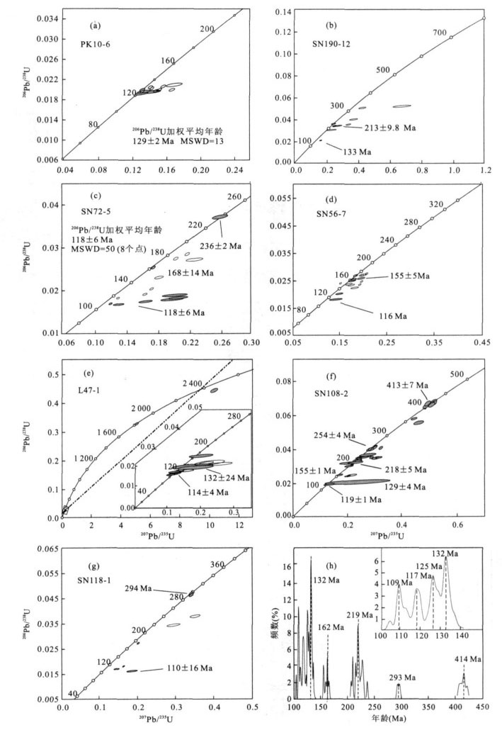
LA-ICP-MS zircon U-Pb dating results are reported for the Mesozoic volcanic rocks from seven wells in the southern Songliao basin in order to constraint their formation time. The Mesozoic volcanic rocks are mainly located in Huoshiling Formation and Yingcheng Formation. The former consists of basaltic andesite, trachyandesite and dacite, the latter is composed of basaltic trachyandesite, trachyandesite and rhyolite. The cathodoluminesence (CL) images and high Th/U ratios of the zircons suggest their magmatic origin. LA-ICP-MS zircon U-Pb dating results indicate that the Mesozoic volcanic rocks in the southern Songliao Basin formed between 110 Ma and 133 Ma. The volcanic rocks in the Huoshiling Formation were erupted during 129-133 Ma, namely early period of the Early Cretaceous, while those in the Yingcheng Formation formed between 110 Ma and 119 Ma, namely late period of the Early Cretaceous. The dating results of captured zircons show that the Middle-Late Jurassic (155-169 Ma), Indosinian (218-236 Ma), Hercynian (254 Ma, 294 Ma), Caledonian (413 Ma), and Precambrian (1 823 Ma and 2 542 Ma) magmatic events had taken place in the basin basement, which is consistent with the zircon U-Pb dating results from the basin basement rocks.
LA-ICP-MS zircon U-Pb dating results are reported for the Mesozoic volcanic rocks from seven wells in the southern Songliao basin in order to constraint their formation time. The Mesozoic volcanic rocks are mainly located in Huoshiling Formation and Yingcheng Formation. The former consists of basaltic andesite, trachyandesite and dacite, the latter is composed of basaltic trachyandesite, trachyandesite and rhyolite. The cathodoluminesence (CL) images and high Th/U ratios of the zircons suggest their magmatic origin. LA-ICP-MS zircon U-Pb dating results indicate that the Mesozoic volcanic rocks in the southern Songliao Basin formed between 110 Ma and 133 Ma. The volcanic rocks in the Huoshiling Formation were erupted during 129-133 Ma, namely early period of the Early Cretaceous, while those in the Yingcheng Formation formed between 110 Ma and 119 Ma, namely late period of the Early Cretaceous. The dating results of captured zircons show that the Middle-Late Jurassic (155-169 Ma), Indosinian (218-236 Ma), Hercynian (254 Ma, 294 Ma), Caledonian (413 Ma), and Precambrian (1 823 Ma and 2 542 Ma) magmatic events had taken place in the basin basement, which is consistent with the zircon U-Pb dating results from the basin basement rocks.


2008, 33(5): 618-626.
Abstract:
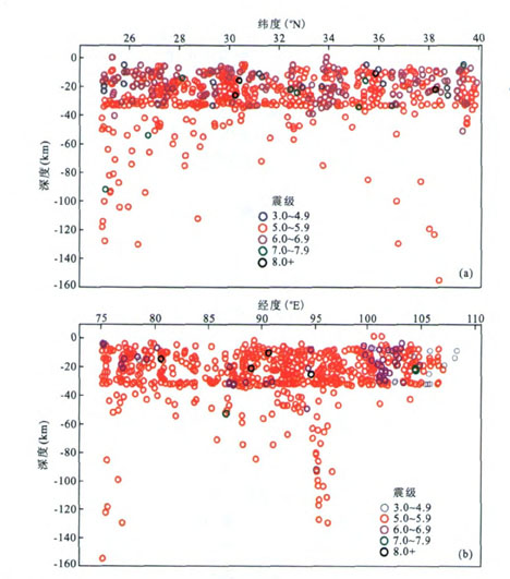
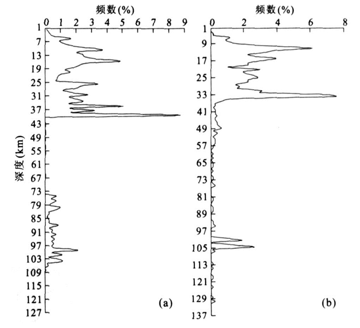
The Qinghai-Tibet plateau intraplate earthquakes are mainly shallow earthquakes, and basically no earthquakes happens in the lower crust. Earthquakes mostly distribute in the range of 15-40 km in depth, basically within the middle crust and concentrate at the depth of 30-33 km as an advantage layer related to the crustal stratification. On the South and North of the plateau, the focal surfaces slightly dip to the center. Some earthquakes concentrate within the range of 70-100 km depth, which may be associated with the detachment between crust and mantle. The intraplate earthquakes in the central Qinghai-Tibet are closely related to the normal faults which are dominant earthquake faults. In short, the Qinghai-Tibet plateau seismic activity distributes along the brittle-ductile transition zone between the brittle upper crust layer and the ductile lower crust. Intraplate seismic activity is a continental dynamic process, irrelevant to plate collision and subduction. The seismogenic layers from shallow to deep are separately the result of ductile-brittle transition, detachment and decoupling between basement and cover; ductile lower crust and brittle upper crust, and ductile lower crust and brittle upper mantle.
The Qinghai-Tibet plateau intraplate earthquakes are mainly shallow earthquakes, and basically no earthquakes happens in the lower crust. Earthquakes mostly distribute in the range of 15-40 km in depth, basically within the middle crust and concentrate at the depth of 30-33 km as an advantage layer related to the crustal stratification. On the South and North of the plateau, the focal surfaces slightly dip to the center. Some earthquakes concentrate within the range of 70-100 km depth, which may be associated with the detachment between crust and mantle. The intraplate earthquakes in the central Qinghai-Tibet are closely related to the normal faults which are dominant earthquake faults. In short, the Qinghai-Tibet plateau seismic activity distributes along the brittle-ductile transition zone between the brittle upper crust layer and the ductile lower crust. Intraplate seismic activity is a continental dynamic process, irrelevant to plate collision and subduction. The seismogenic layers from shallow to deep are separately the result of ductile-brittle transition, detachment and decoupling between basement and cover; ductile lower crust and brittle upper crust, and ductile lower crust and brittle upper mantle.


2008, 33(5): 627-634.
Abstract:
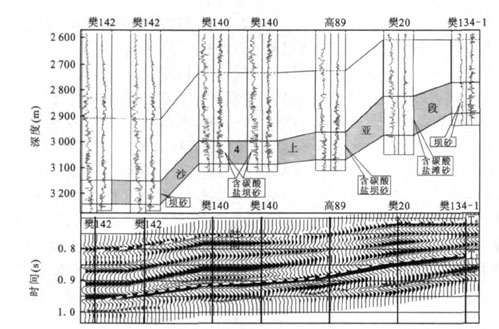
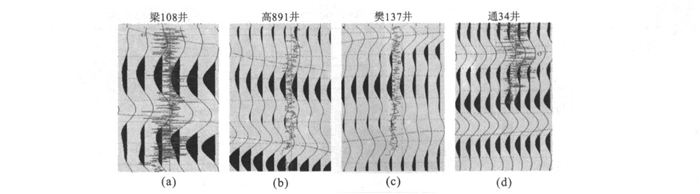
Beach-bar reservoirs are characterized by sand-mud interlayering, thin sand strata, and high seismic velocity of carbonate interbeds, which increases the difficulty of seismic interpretation and reservoir prediction. Based on the lithologic combination of the beach-bar sand of Es4s in the western Dongying sag, seismic "waveform" analysis was applied to its reservoir prediction. Firstly, we defined three dominate types of the waveform of the beach-bar sand and established the actual seismic forward models for different lithological combinations of beach bar reservoir. Then, by studying actual seismic forward model, the waveform characters of different lithologic combinations were analyzed. Relationships between the waveform modes and the different lithologic combinations were generalized as well. In the end, the seismic waveforms were classified by restriction of logging data, and the scope of beneficial beach-bar reservoir was defined.
Beach-bar reservoirs are characterized by sand-mud interlayering, thin sand strata, and high seismic velocity of carbonate interbeds, which increases the difficulty of seismic interpretation and reservoir prediction. Based on the lithologic combination of the beach-bar sand of Es4s in the western Dongying sag, seismic "waveform" analysis was applied to its reservoir prediction. Firstly, we defined three dominate types of the waveform of the beach-bar sand and established the actual seismic forward models for different lithological combinations of beach bar reservoir. Then, by studying actual seismic forward model, the waveform characters of different lithologic combinations were analyzed. Relationships between the waveform modes and the different lithologic combinations were generalized as well. In the end, the seismic waveforms were classified by restriction of logging data, and the scope of beneficial beach-bar reservoir was defined.


2008, 33(5): 635-642.
Abstract:
The central uplift of Tarim Basin (Tazhong Uplift) has become a hot exploration target in western China. Totally 104 oil samples were sampled and analyzed by conventional geochemical as well as compound specific isotopic approaches. The oil were divided into four genetic types. Type-Ⅰ is characterized by relatively heavier values of n-alkanes carbon isotope (-29.6‰~-29.1‰), and generally a reversed "L" shape of relative abundance of C27, C28 and C29 regular steranes with 4-metyl sterane and dinosteranes as well as gammacerane relatively enriched whereas diasteranes and diahopanes less developed. This type of oil shares typical features of Cambrian-low Ordivican derived oil (TD2, ∈-O1) in the Tarim basin. Type-Ⅱ has relatively lighter carbon isotope values of n-alkanes (-34‰~-35.6‰), and is poor in dinosteranes with "V" shape of C27, C28 and C29 regular steranes. This type of oil correlates well middle-upper Ordovician derived oil (YM2, O1) in the basin. Type-Ⅲ is distinguished from other oils by completely high concentrations of dibenzothiophene, which was primarily situated in TZ4 and TZ1-6 Blocks. Type-Ⅳ is mixed oil of type-Ⅰ and Ⅱ, and characterized by an intermediate carbon isotope value of type-Ⅰ and Ⅱ. This type oil is predominant in amount and widely distributed in the Tazhong Uplift. Oil -oil correlations showed that the oil analyzed was sourced from at least two sets of source rocks (i.e., ∈-O1 and O2+3, respectively). The un-consistency of the biomarkers (indicating ∈-O1 genetic affinity) and the compound specific compounds of n-alkanes (indicating more of O2+3 genetic affinity) in some oils analyzed indicates that the oils were widely mixed with different sources. The physical and chemical properties of the oils vary with tectonic belt and horizons suggest such typical characteristics of composite basin as multi-source and multi-stage of hydrocarbons migration and accumulation of the oils as well as obvious heterogeneities of carbonatite reservoir rock. The oil-mixing model suggested in this study is significant for further oil exploration.
The central uplift of Tarim Basin (Tazhong Uplift) has become a hot exploration target in western China. Totally 104 oil samples were sampled and analyzed by conventional geochemical as well as compound specific isotopic approaches. The oil were divided into four genetic types. Type-Ⅰ is characterized by relatively heavier values of n-alkanes carbon isotope (-29.6‰~-29.1‰), and generally a reversed "L" shape of relative abundance of C27, C28 and C29 regular steranes with 4-metyl sterane and dinosteranes as well as gammacerane relatively enriched whereas diasteranes and diahopanes less developed. This type of oil shares typical features of Cambrian-low Ordivican derived oil (TD2, ∈-O1) in the Tarim basin. Type-Ⅱ has relatively lighter carbon isotope values of n-alkanes (-34‰~-35.6‰), and is poor in dinosteranes with "V" shape of C27, C28 and C29 regular steranes. This type of oil correlates well middle-upper Ordovician derived oil (YM2, O1) in the basin. Type-Ⅲ is distinguished from other oils by completely high concentrations of dibenzothiophene, which was primarily situated in TZ4 and TZ1-6 Blocks. Type-Ⅳ is mixed oil of type-Ⅰ and Ⅱ, and characterized by an intermediate carbon isotope value of type-Ⅰ and Ⅱ. This type oil is predominant in amount and widely distributed in the Tazhong Uplift. Oil -oil correlations showed that the oil analyzed was sourced from at least two sets of source rocks (i.e., ∈-O1 and O2+3, respectively). The un-consistency of the biomarkers (indicating ∈-O1 genetic affinity) and the compound specific compounds of n-alkanes (indicating more of O2+3 genetic affinity) in some oils analyzed indicates that the oils were widely mixed with different sources. The physical and chemical properties of the oils vary with tectonic belt and horizons suggest such typical characteristics of composite basin as multi-source and multi-stage of hydrocarbons migration and accumulation of the oils as well as obvious heterogeneities of carbonatite reservoir rock. The oil-mixing model suggested in this study is significant for further oil exploration.


2008, 33(5): 643-650.
Abstract:
Researches on sedimentary patterns and structural control across toe thrust belts can demonstrate the distribution and evolution of deep-water sediments. In this paper, mechanism of limb rotation in growth strata and technique of seismic facies analysis are used. There are three features in the minibasins induced by gravitational sliding on the slope: the firstly, feature is surface of unconformity developed by onlap on minibasin margins or surface of unconformity truncated by mass-transport-complex are sequence boundary in the study area; the secondly, accommodation of gravity flow is controlled by uplift rate and sedimentation rate, and styles of filling in the minibasins are dominated by the interrelationship between the two factors; and the third, there are two stacking patterns that consists of upward of turbidite fan-hemipelagic drape mud or mass-transport complexes-turbidite fan-hemipelagic drape mud. Models showing evolution of sediment in Single minibasin and in multiple minibasins are built based on the study of uplift and rate of deposition.
Researches on sedimentary patterns and structural control across toe thrust belts can demonstrate the distribution and evolution of deep-water sediments. In this paper, mechanism of limb rotation in growth strata and technique of seismic facies analysis are used. There are three features in the minibasins induced by gravitational sliding on the slope: the firstly, feature is surface of unconformity developed by onlap on minibasin margins or surface of unconformity truncated by mass-transport-complex are sequence boundary in the study area; the secondly, accommodation of gravity flow is controlled by uplift rate and sedimentation rate, and styles of filling in the minibasins are dominated by the interrelationship between the two factors; and the third, there are two stacking patterns that consists of upward of turbidite fan-hemipelagic drape mud or mass-transport complexes-turbidite fan-hemipelagic drape mud. Models showing evolution of sediment in Single minibasin and in multiple minibasins are built based on the study of uplift and rate of deposition.


2008, 33(5): 651-660.
Abstract:
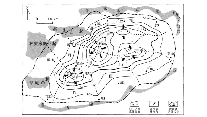
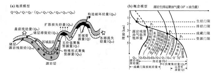
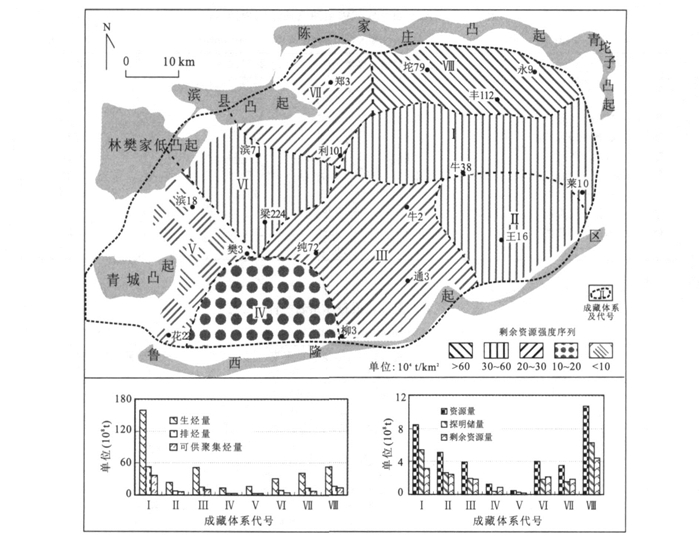
The theory of oil accumulation threshold describes the formation and distribution of reservoirs quantitatively, which is better than other theories in predicting undiscovered resources in mature exploration area. In this article, Dongying sag was divided into eight petroleum accumulation system, and they were quantitatively estimated by the the theory of oil accumulation threshold. The results shows that all of them have entered their thresholds of oil accumulation and resources. The total resources undiscovered is 17.03×10⁸ t in Dongying sag. Ⅷ and Ⅰ petroleum accumulation systems have 4.41×10⁸ t and 3.10×10⁸ t undiscovered resources, respectively, which are much more than rest petroleum accumulation systems. Ⅵ and Ⅴ petroleum accumulation systems have the least undiscovered resources 0.90×10⁸ t and 0.22×10⁸ t, respectively. So Ⅷ and Ⅰ petroleum accumulation systems are the potential areas to explore.
The theory of oil accumulation threshold describes the formation and distribution of reservoirs quantitatively, which is better than other theories in predicting undiscovered resources in mature exploration area. In this article, Dongying sag was divided into eight petroleum accumulation system, and they were quantitatively estimated by the the theory of oil accumulation threshold. The results shows that all of them have entered their thresholds of oil accumulation and resources. The total resources undiscovered is 17.03×10⁸ t in Dongying sag. Ⅷ and Ⅰ petroleum accumulation systems have 4.41×10⁸ t and 3.10×10⁸ t undiscovered resources, respectively, which are much more than rest petroleum accumulation systems. Ⅵ and Ⅴ petroleum accumulation systems have the least undiscovered resources 0.90×10⁸ t and 0.22×10⁸ t, respectively. So Ⅷ and Ⅰ petroleum accumulation systems are the potential areas to explore.
2008, 33(5): 661-671.
Abstract:
In order to understand the vertical distribution of natural radioactivity of the upper crust of the ultra-high pressure (UHP) metamorphic belt in Donghai County, Jiangsu province, as well as the influence of the retrogression intensity of eclogite on the concentration of radioelement, and the influence of radiogenic heat production rate on the geothermal gradient, the natural radioactivity logs (gamma ray and gamma spectrometry logs) from the main hole of the Chinese Continental Scientific Drilling (CCSD) were utilized to obtain the natural gamma intensity and the concentration of U, Th and K of main lithologies and the heat production rate log. The natural gamma intensity and concentration of U, Th and K gradually increase from serpentine to eclogite, amphibolite, paragneiss, and orthogneiss. With the strengthening of the retrogression of eclogite, the concentration of U, Th and K of eclogite increase. This indicates that some exotic fluids with U, Th and K elements join in the retrograde metamorphism. The vertical distribution of the natural gamma intensity and concentration of U, Th and K is dominated mainly by lithology. The natural gamma intensity approximately increases with the depth. The heat production rate and the natural gamma log have a good linear relationship. The formation with high radioactivity could cause disturbance and low anomalies on geothermal gradient on its upper formation.
In order to understand the vertical distribution of natural radioactivity of the upper crust of the ultra-high pressure (UHP) metamorphic belt in Donghai County, Jiangsu province, as well as the influence of the retrogression intensity of eclogite on the concentration of radioelement, and the influence of radiogenic heat production rate on the geothermal gradient, the natural radioactivity logs (gamma ray and gamma spectrometry logs) from the main hole of the Chinese Continental Scientific Drilling (CCSD) were utilized to obtain the natural gamma intensity and the concentration of U, Th and K of main lithologies and the heat production rate log. The natural gamma intensity and concentration of U, Th and K gradually increase from serpentine to eclogite, amphibolite, paragneiss, and orthogneiss. With the strengthening of the retrogression of eclogite, the concentration of U, Th and K of eclogite increase. This indicates that some exotic fluids with U, Th and K elements join in the retrograde metamorphism. The vertical distribution of the natural gamma intensity and concentration of U, Th and K is dominated mainly by lithology. The natural gamma intensity approximately increases with the depth. The heat production rate and the natural gamma log have a good linear relationship. The formation with high radioactivity could cause disturbance and low anomalies on geothermal gradient on its upper formation.


2008, 33(5): 672-678.
Abstract:
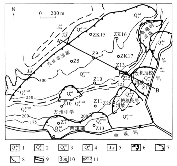
Anlesi landslide is a typical gentle-dip landslide forming in the red clastic rocks in the Three Gorges Reservoir area. In order to discover the mechanism of the gentle-dip landslides forming in the red clastic rocks, the slip zone characteristics of Anlesi landslide were studied in detail in this paper. Field investigations show that the slip zone of Anlesi landslide was formed from a white mudstone (an incompetent bed) in Jurassic red strata by extrusion stress. The direction of the striations on the sliding surface indicates that the latest sliding direction of the landslide is 100°. The X-ray diffraction and infrared ray analysis reveal that the main mineral components of the slip zone are montmorillonite, illite, feldspar and quartz, et al.. The significant character is that the slip zone contains a large amount of montmorillonite, and the sliding surface contains more montmorillonite than the slip zone does. The results of scanning electron micrograph display that the microstructures of the slip zone are mainly sheet crystals and directional crystal structures, and micro striations developed well. A set of tests were conducted on the slip zone specimens to obtain the physico-mechanical characteristics. Test results show that the slip zone is medium swelling potential slity clay, and shear strength becomes very low once the slip zone absorbs water to saturation. The characteristics of the slip zone mentioned above make it possible to discover the mechanism of the gentle-dip landslides forming in the red clastic rocks.
Anlesi landslide is a typical gentle-dip landslide forming in the red clastic rocks in the Three Gorges Reservoir area. In order to discover the mechanism of the gentle-dip landslides forming in the red clastic rocks, the slip zone characteristics of Anlesi landslide were studied in detail in this paper. Field investigations show that the slip zone of Anlesi landslide was formed from a white mudstone (an incompetent bed) in Jurassic red strata by extrusion stress. The direction of the striations on the sliding surface indicates that the latest sliding direction of the landslide is 100°. The X-ray diffraction and infrared ray analysis reveal that the main mineral components of the slip zone are montmorillonite, illite, feldspar and quartz, et al.. The significant character is that the slip zone contains a large amount of montmorillonite, and the sliding surface contains more montmorillonite than the slip zone does. The results of scanning electron micrograph display that the microstructures of the slip zone are mainly sheet crystals and directional crystal structures, and micro striations developed well. A set of tests were conducted on the slip zone specimens to obtain the physico-mechanical characteristics. Test results show that the slip zone is medium swelling potential slity clay, and shear strength becomes very low once the slip zone absorbs water to saturation. The characteristics of the slip zone mentioned above make it possible to discover the mechanism of the gentle-dip landslides forming in the red clastic rocks.


2008, 33(5): 679-686.
Abstract:
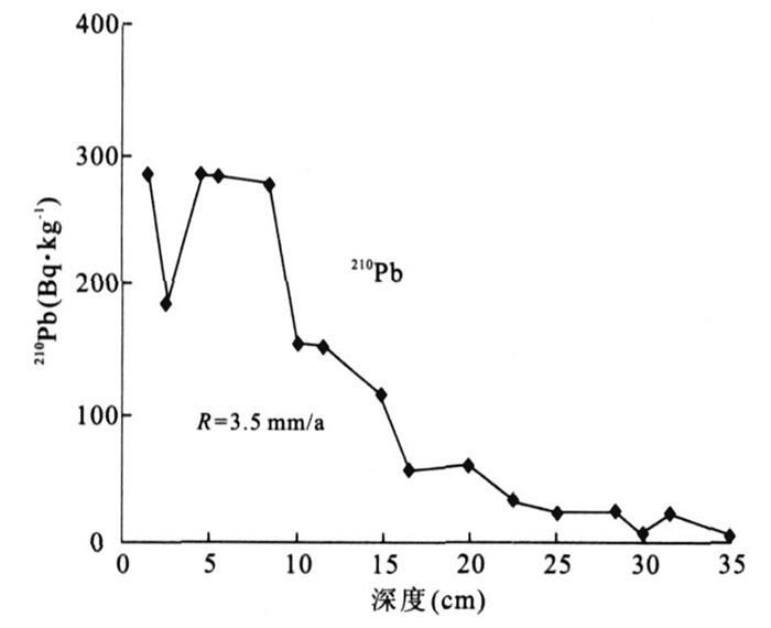
In order to understand the response of lake ecosystem to the human activity, recent core sediments are employed to explore eutrophication history of the Liangzi Lake, Hubei Province. Pigments and hydrobiological remains are employed to reconstruct lake ecosystem changes in the past 100 years on the basis of 210Pb dating and historical document records. Sediment pigments have specific environmental indication for eutrophication occurrence attributed to rising concentration of chlorophyll & derivatives (CD), total carotene (TC), Myxoxanthophyll (Myx) and Oscillaxanthin (Osc). Pigment assemblage zones together with hydrobiological remains show that Liangzi Lake ecosystem has undergone five distinct stages, corresponding to early poor eutrophication, fine ecological environment (1885-1902A.D.), slight eutrophication (1902-1964A.D.), moderate eutrophication (1964-1988A.D.), eutrophication (1988-1998A.D.), moderate eutrophication (1998-2003A.D.), respectively. The amount of some hydrobiological remains, especially Zannichellia sp., Najas oguraensis, Nymphoides peltatum, Parafossarulus striatulus, Corbicula fluminea and Arcella sp., which are sensitive to eutrophication occurrence, change in inverse proportion to pigment concentration. Comparison of lake eutrophication history with human activity shows that eutrophication occurrence has a strong relationship with human interference such as intensive reclamation and flux of agricultural nutrient loss. Lake ecosystem evolution is controlled by major human activities. Our results are significant for better understanding of the interaction between the human activities and the change of lake ecosystem, which facilitates the regulation of lake environment management.
In order to understand the response of lake ecosystem to the human activity, recent core sediments are employed to explore eutrophication history of the Liangzi Lake, Hubei Province. Pigments and hydrobiological remains are employed to reconstruct lake ecosystem changes in the past 100 years on the basis of 210Pb dating and historical document records. Sediment pigments have specific environmental indication for eutrophication occurrence attributed to rising concentration of chlorophyll & derivatives (CD), total carotene (TC), Myxoxanthophyll (Myx) and Oscillaxanthin (Osc). Pigment assemblage zones together with hydrobiological remains show that Liangzi Lake ecosystem has undergone five distinct stages, corresponding to early poor eutrophication, fine ecological environment (1885-1902A.D.), slight eutrophication (1902-1964A.D.), moderate eutrophication (1964-1988A.D.), eutrophication (1988-1998A.D.), moderate eutrophication (1998-2003A.D.), respectively. The amount of some hydrobiological remains, especially Zannichellia sp., Najas oguraensis, Nymphoides peltatum, Parafossarulus striatulus, Corbicula fluminea and Arcella sp., which are sensitive to eutrophication occurrence, change in inverse proportion to pigment concentration. Comparison of lake eutrophication history with human activity shows that eutrophication occurrence has a strong relationship with human interference such as intensive reclamation and flux of agricultural nutrient loss. Lake ecosystem evolution is controlled by major human activities. Our results are significant for better understanding of the interaction between the human activities and the change of lake ecosystem, which facilitates the regulation of lake environment management.


2008, 33(5): 687-692.
Abstract:
The water level will periodically fluctuate between 145 and 175m since normal water level storage in Three Gorges reservoir, while the ground water seepage of landslide will be subject to great changes, which may lead to landslide instability. So it is of great significance to study the influence of water level fluctuatation on the bank landslide stability. In this paper, a polynomial constrained optimized model for soil-water characteristic curve is put forward and the saturated-unsaturated seepage flow numerical model is applied. In addition, Zhaoshuling landslide is taken as an example, water seepage fields are simulated by using finite element method with the water level fluctuation between 145 and 175m. The transient pore water pressures are used for limit equilibrium analyses of landslides with taking the effects of suction on shear strength of unsaturated soils into consideration. Then we discuss the effect of the fluctuation of water level in Three Gorges reservoir on the bank landslide stability. The result shows that a polynomial constrained optimized model may well fit the characteristic curve of soil and water of unsaturated soil. The stability coefficient increases gradually in general along with reservoir water level rise and the stability coefficient decreases gradually in general along with the fall of reservoir water level. However, when the reservoir water level reached 155m, whether it rises from 145m or falls from 175m, the stability coefficient is smallest; while the stability coefficient in period of reservoir water level rising from 145m to 175m is larger than that in period of falling from 175m to 145m.
The water level will periodically fluctuate between 145 and 175m since normal water level storage in Three Gorges reservoir, while the ground water seepage of landslide will be subject to great changes, which may lead to landslide instability. So it is of great significance to study the influence of water level fluctuatation on the bank landslide stability. In this paper, a polynomial constrained optimized model for soil-water characteristic curve is put forward and the saturated-unsaturated seepage flow numerical model is applied. In addition, Zhaoshuling landslide is taken as an example, water seepage fields are simulated by using finite element method with the water level fluctuation between 145 and 175m. The transient pore water pressures are used for limit equilibrium analyses of landslides with taking the effects of suction on shear strength of unsaturated soils into consideration. Then we discuss the effect of the fluctuation of water level in Three Gorges reservoir on the bank landslide stability. The result shows that a polynomial constrained optimized model may well fit the characteristic curve of soil and water of unsaturated soil. The stability coefficient increases gradually in general along with reservoir water level rise and the stability coefficient decreases gradually in general along with the fall of reservoir water level. However, when the reservoir water level reached 155m, whether it rises from 145m or falls from 175m, the stability coefficient is smallest; while the stability coefficient in period of reservoir water level rising from 145m to 175m is larger than that in period of falling from 175m to 145m.


2008, 33(5): 693-698.
Abstract:
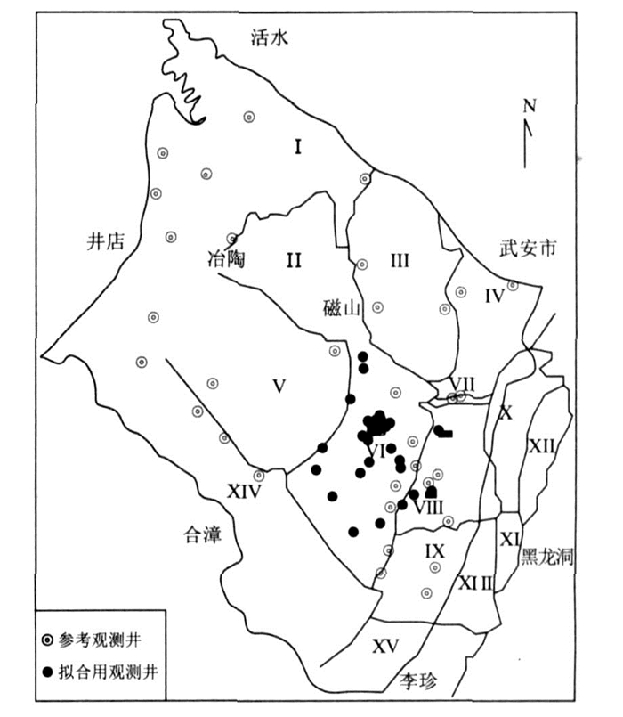
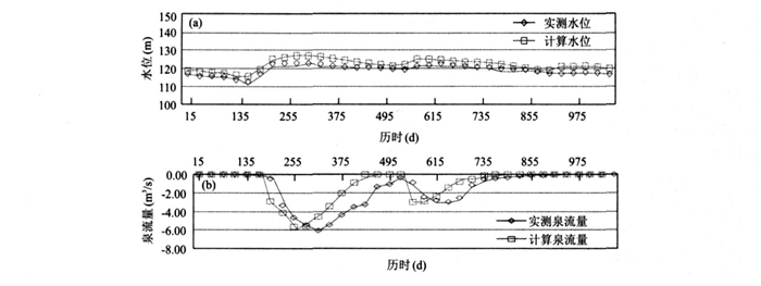
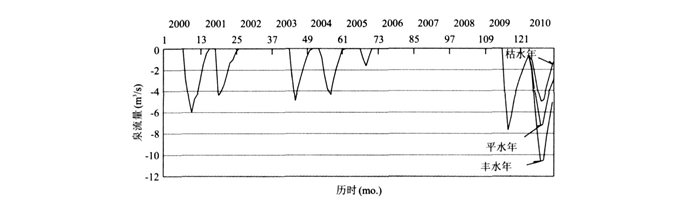
In order to evaluate the water resources of the whole drainage area of HeiLongdong, the pape establishes groundwater seepage model of the whole spring area of HeiLongdong through the in-depth research of geological condition and the date of water level of this area based on water balance theory, groundwater seepage flow theory and Galerkin finite element theory. Moreover, with the assistance of grey series forecasting model and the rule of the annual precipitation, the annual average precipitation, groundwater flow field, groundwater level and spring flow in the future under current exploitation circumstances were forecasted. If 2010 is a high flow year (guarantee ratio 20%), or median flow year (guarantee ratio 50%), or even low flow year (guarantee ratio 75%), the underground water level of HeiLongdong spring in flood season will exceed 130m, or reach 130m, or even below 130m, and the spring flow in flood season will exceed 10m3 /s, 7m3/s, 5m3/s respectively. The result of prediction is of great significance to management and exploitation of water resources in HeiLongdong spring area.
In order to evaluate the water resources of the whole drainage area of HeiLongdong, the pape establishes groundwater seepage model of the whole spring area of HeiLongdong through the in-depth research of geological condition and the date of water level of this area based on water balance theory, groundwater seepage flow theory and Galerkin finite element theory. Moreover, with the assistance of grey series forecasting model and the rule of the annual precipitation, the annual average precipitation, groundwater flow field, groundwater level and spring flow in the future under current exploitation circumstances were forecasted. If 2010 is a high flow year (guarantee ratio 20%), or median flow year (guarantee ratio 50%), or even low flow year (guarantee ratio 75%), the underground water level of HeiLongdong spring in flood season will exceed 130m, or reach 130m, or even below 130m, and the spring flow in flood season will exceed 10m3 /s, 7m3/s, 5m3/s respectively. The result of prediction is of great significance to management and exploitation of water resources in HeiLongdong spring area.


2008, 33(5): 699-705.
Abstract:
Taking into account of complicated geological environment, large deformation, high stress and long-time use, stability analysis for surrounding rock is very important for the deep, long and wide tunnel engineering. Defining parameters by displacement back analysis has been the focus of current study. This method can be used to deal with the complicated non-linear relationship between the parameters of surrounding rock and the measuring information, and to judge and adjust the scheme of second support, while artificial Intelligence are adept in identification, representation and management of the non-linear relationship. The paper, through deformation monitoring for surrounding rock of Yunling tunnel of Shi-Man highway, combined the system of biologic emulation and the software of fast lagrangian analysis of continua (FLAC) to conduct direct analysis, took the advantage of the high nonlinearity, good reasoning and integration of neural network and obtained output vector by data-analysis software. Then we took adaptive immunity algorithm as searching tool to look for the best network structure for parameters in all room, searched for the best parameters with back analysis according information gained by measuring practically. Finally, direct calculation came out the results. This back analysis, improved the primary parameters of physical and mechanical parameters of tunnel surrounding rock, adjusted the scheme of support and obtained satisfied conclusion. The research results show that the back analysis proposed in this paper is of practical significance to the stability analysis of the tunnel surrounding rock and to informational design.
Taking into account of complicated geological environment, large deformation, high stress and long-time use, stability analysis for surrounding rock is very important for the deep, long and wide tunnel engineering. Defining parameters by displacement back analysis has been the focus of current study. This method can be used to deal with the complicated non-linear relationship between the parameters of surrounding rock and the measuring information, and to judge and adjust the scheme of second support, while artificial Intelligence are adept in identification, representation and management of the non-linear relationship. The paper, through deformation monitoring for surrounding rock of Yunling tunnel of Shi-Man highway, combined the system of biologic emulation and the software of fast lagrangian analysis of continua (FLAC) to conduct direct analysis, took the advantage of the high nonlinearity, good reasoning and integration of neural network and obtained output vector by data-analysis software. Then we took adaptive immunity algorithm as searching tool to look for the best network structure for parameters in all room, searched for the best parameters with back analysis according information gained by measuring practically. Finally, direct calculation came out the results. This back analysis, improved the primary parameters of physical and mechanical parameters of tunnel surrounding rock, adjusted the scheme of support and obtained satisfied conclusion. The research results show that the back analysis proposed in this paper is of practical significance to the stability analysis of the tunnel surrounding rock and to informational design.


2008, 33(5): 706-715.
Abstract:
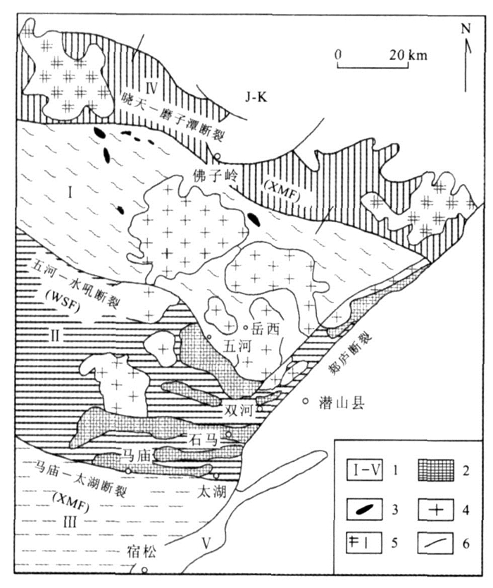
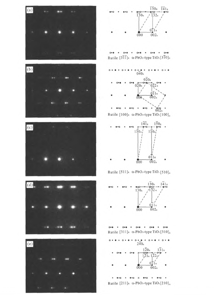
The depth of the continental deep subduction is of vital importance for better understanding of the dynamics of exhumation process of ultrahigh pressure metamorphic rocks in the continental collision orogen belt. The crystal of α-PbO2-type TiO2 was found in omphacite from coesite-bearing eclogite at Shima in the Dabie Mountains, China. A natural ultrahigh-pressure phase of titanium oxide with α-PbO2-structure has been identified through high-resolution transmission electron microscopy (HRTEM) and energy-dispersive X-ray spectrometer (EDS) in jadeite quartzite at Shuanghe in the Dabie Mountains, China. The reservation of nano-scale lamellae of the α-PbO2-type polymorph of TiO2 provides a new evidence of ultra high-pressure, metamorphism at 6-7GPa, 730-870℃. It implies a burial of continental crustal rocks to depth between 170-200 kilometers or deeper, and also implies exhumation of subducted continental crust to the Earth′s surface was presumably rapid, though at an uncertain rate.
The depth of the continental deep subduction is of vital importance for better understanding of the dynamics of exhumation process of ultrahigh pressure metamorphic rocks in the continental collision orogen belt. The crystal of α-PbO2-type TiO2 was found in omphacite from coesite-bearing eclogite at Shima in the Dabie Mountains, China. A natural ultrahigh-pressure phase of titanium oxide with α-PbO2-structure has been identified through high-resolution transmission electron microscopy (HRTEM) and energy-dispersive X-ray spectrometer (EDS) in jadeite quartzite at Shuanghe in the Dabie Mountains, China. The reservation of nano-scale lamellae of the α-PbO2-type polymorph of TiO2 provides a new evidence of ultra high-pressure, metamorphism at 6-7GPa, 730-870℃. It implies a burial of continental crustal rocks to depth between 170-200 kilometers or deeper, and also implies exhumation of subducted continental crust to the Earth′s surface was presumably rapid, though at an uncertain rate.


2008, 33(5): 716-722.
Abstract:
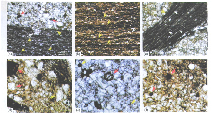
In order to realize the character of composition and structure of mix-layer clay minerals from Chuanlinggou Formation of Changcheng System in Jixian County, Tianjin City, X-ray powder diffraction (XRD) and high-resolution transmission electron microscope (HRTEM) are used to study the minerals. By contrasting air-dried oriented aggregate sample, Ca cation saturation sample, Ca saturated glycerol salvation sample and heated 375℃ and 550℃ of glycerol salvation samples, it is confirmed that the mix-layer clay minerals from this area is illite/smectite (I/S) order and disorder mix-layer clay minerals and chlorite/smectite (Chl/S) disorder mix-layer clay minerals. The obtained lattice images from high-resolution transmission electron microscope of I/S order and disorder mix-layer minerals and Chl/S disorder mix-layer minerals show the structure character of layer stacking of I/S and Chl/S from this area. This study provides some important structure information of mix-layer clay minerals for the well-known Mesoproterozoic section of Jixian County.
In order to realize the character of composition and structure of mix-layer clay minerals from Chuanlinggou Formation of Changcheng System in Jixian County, Tianjin City, X-ray powder diffraction (XRD) and high-resolution transmission electron microscope (HRTEM) are used to study the minerals. By contrasting air-dried oriented aggregate sample, Ca cation saturation sample, Ca saturated glycerol salvation sample and heated 375℃ and 550℃ of glycerol salvation samples, it is confirmed that the mix-layer clay minerals from this area is illite/smectite (I/S) order and disorder mix-layer clay minerals and chlorite/smectite (Chl/S) disorder mix-layer clay minerals. The obtained lattice images from high-resolution transmission electron microscope of I/S order and disorder mix-layer minerals and Chl/S disorder mix-layer minerals show the structure character of layer stacking of I/S and Chl/S from this area. This study provides some important structure information of mix-layer clay minerals for the well-known Mesoproterozoic section of Jixian County.


