2009 Vol. 34, No. 4
Display Method:
 PDF 936KB
2009, 34(4): 547-568.
Abstract:
Gold and copper are two different types of mineral resources.Gold and copper are often accompanied, while tungsten and tin are often accompanied, but gold and copper are usually not together with tungsten and tin.Researches indicate the gold and copper, mainly connected with the adakite and Himalaya-type granite, originated in the thickened bottom of crust.And correspondingly, plateau or the mountain occur on the earth's surface.The tungsten and tin are mainly relevant to the granite from Nanling area of China, and represent the thinned crust originated in the plain area with the relative low elevation.Therfore, from the view of prospecting, the gold and copper should be prospected in a mountain, while the tungsten and tin should be prospected in a plain.In this paper, we suggest that seven mountains in China (such as North Mountain of the North China, West Qinling-East Kunlun mountains, Erguna mountain, Songpan-Zhongdian mountain, Hunan-Jiangxi mountain, Fujian-Zhejiang mountain and the Ailaoshan-Qiangtang mountain), two plateaus (East China Plateau and Hunan Range) and present Qinghai-Xizang Plateau would be the spot where gold and copper can be prospected since the Triassic period in China.We propose to prospect gold and copper ore on these plateaus and mountains, and point out that the gold is closely related to the Himalaya type granite.We believe that the South China is best place to prospect tungsten and tin, but attention should be also paid on prospecting tungsten and tin in other places.
Gold and copper are two different types of mineral resources.Gold and copper are often accompanied, while tungsten and tin are often accompanied, but gold and copper are usually not together with tungsten and tin.Researches indicate the gold and copper, mainly connected with the adakite and Himalaya-type granite, originated in the thickened bottom of crust.And correspondingly, plateau or the mountain occur on the earth's surface.The tungsten and tin are mainly relevant to the granite from Nanling area of China, and represent the thinned crust originated in the plain area with the relative low elevation.Therfore, from the view of prospecting, the gold and copper should be prospected in a mountain, while the tungsten and tin should be prospected in a plain.In this paper, we suggest that seven mountains in China (such as North Mountain of the North China, West Qinling-East Kunlun mountains, Erguna mountain, Songpan-Zhongdian mountain, Hunan-Jiangxi mountain, Fujian-Zhejiang mountain and the Ailaoshan-Qiangtang mountain), two plateaus (East China Plateau and Hunan Range) and present Qinghai-Xizang Plateau would be the spot where gold and copper can be prospected since the Triassic period in China.We propose to prospect gold and copper ore on these plateaus and mountains, and point out that the gold is closely related to the Himalaya type granite.We believe that the South China is best place to prospect tungsten and tin, but attention should be also paid on prospecting tungsten and tin in other places.


2009, 34(4): 569-584.
Abstract:
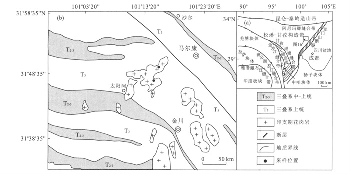
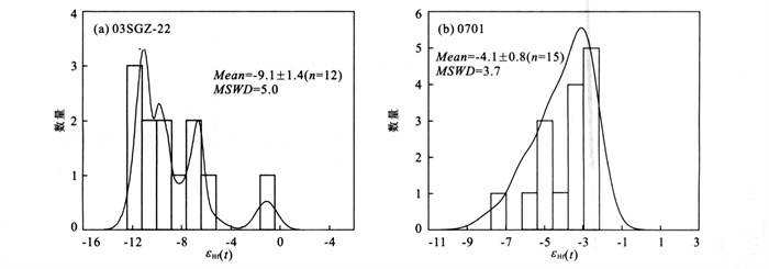
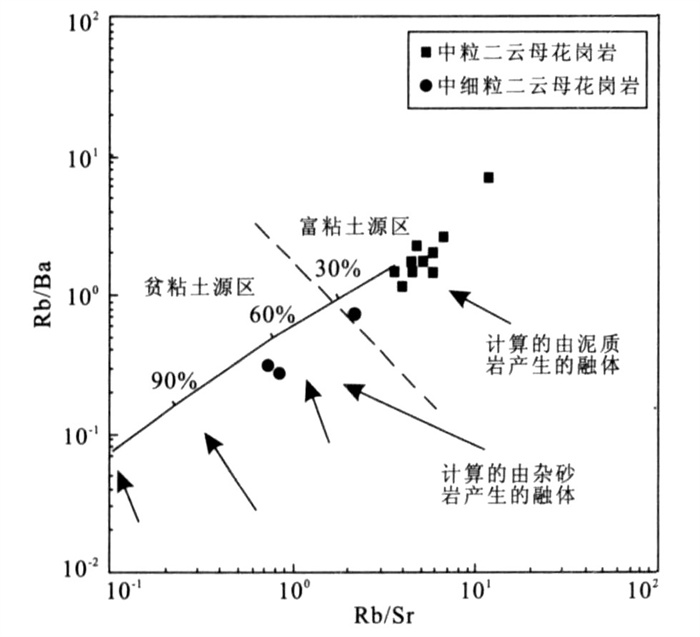
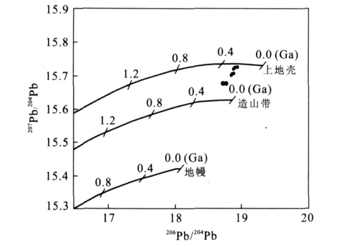
In the Songpan fold belt, Indosinian post-collision granitoids, including adakitic, A-type and I-type granitoids, are widespread.However, studies on Indosinian strongly peraluminous granite in this area are rare.The Markan granites, including medium-grained two-mica granite and medium-fine grained two-mica granite, are strongly peraluminous granites with Al index (A/CNK) =1.10-1.20.By using LA-ICP-MS zircon dating method, magma crystallization ages 208±2 Ma for the medium-grained two-mica granite and 200±2 Ma for the medium-fine grained two-mica granite are obtained.Both the two-mica granites show K2O/Na2O=1.13-1.75, and are enriched in Rb, Th and U etc while depleted in Sr, Ba, Co and Ni etc.REE compositions display strongly fractionated patterns, with (La/Yb)N =6.08-51.84 and Eu/Eu*=0.15-0.65.In Sr-Nd-Hf isotopic compositions, they have initial 87Sr/86Sr ratios (ISr) of 0.707 12-0.711 37, εNd(t) values of-10.36 to-8.43 and zircon εHf(t) values of-11.8 to-1.1.Geochemical and Sr-Nd-Hf isotopic compositions suggest that the magmas for the medium-grained and medium-fine grained two-mica granites were derived from patial melting of argillaceous and greywacke sediments, respectively.According to the combined analysis of geological background, regional tectono-magmatic events and magmatism composition, Indosinian lithospheric delamination can account for the magma generation of the Markan strongly peraluminous granites.The Indosinian lithospheric delamination resulted in mantle asthenospheric upwelling, which promoted not only partial melting of the thickened lower crust (e.g.the adakitic and I-type granitoid magma gerneration), but also partial melting of the middle-lower crust (e.g.the Markan granite gerneration).This indicates that the Indosinian lithospheric delamination in the Songpan fold belt had resulted in partial melting at different levels of crust.
In the Songpan fold belt, Indosinian post-collision granitoids, including adakitic, A-type and I-type granitoids, are widespread.However, studies on Indosinian strongly peraluminous granite in this area are rare.The Markan granites, including medium-grained two-mica granite and medium-fine grained two-mica granite, are strongly peraluminous granites with Al index (A/CNK) =1.10-1.20.By using LA-ICP-MS zircon dating method, magma crystallization ages 208±2 Ma for the medium-grained two-mica granite and 200±2 Ma for the medium-fine grained two-mica granite are obtained.Both the two-mica granites show K2O/Na2O=1.13-1.75, and are enriched in Rb, Th and U etc while depleted in Sr, Ba, Co and Ni etc.REE compositions display strongly fractionated patterns, with (La/Yb)N =6.08-51.84 and Eu/Eu*=0.15-0.65.In Sr-Nd-Hf isotopic compositions, they have initial 87Sr/86Sr ratios (ISr) of 0.707 12-0.711 37, εNd(t) values of-10.36 to-8.43 and zircon εHf(t) values of-11.8 to-1.1.Geochemical and Sr-Nd-Hf isotopic compositions suggest that the magmas for the medium-grained and medium-fine grained two-mica granites were derived from patial melting of argillaceous and greywacke sediments, respectively.According to the combined analysis of geological background, regional tectono-magmatic events and magmatism composition, Indosinian lithospheric delamination can account for the magma generation of the Markan strongly peraluminous granites.The Indosinian lithospheric delamination resulted in mantle asthenospheric upwelling, which promoted not only partial melting of the thickened lower crust (e.g.the adakitic and I-type granitoid magma gerneration), but also partial melting of the middle-lower crust (e.g.the Markan granite gerneration).This indicates that the Indosinian lithospheric delamination in the Songpan fold belt had resulted in partial melting at different levels of crust.


2009, 34(4): 585-594.
Abstract:
Jinla Pb-Zn-Ag poly-metallic ore field across China and Myanmar, located at the south segment of the Mengtong-Gengma-Ximeng passive continental margin of Proterozoic era-Palaeozoic era, the eastern margin of the Baoshan-Shantai Massif, includes the Nanla and the Jinchang Pb-Zn-Ag deposits.According to the studies on both the element geochemistry of the host rocks, the granites, and the ore deposits and the sulphur-lead isotopes as well as fluid inclusion from the ore deposits in Jinchang Pb-Zn-Ag deposits.The conclusions are drawn as follows. (1) The granites in this ore field are richer in Pb, Zn, Cu, Au, Sn, and W than in other granites, and the K-feldspar granite porphyry has a closer relationship with the mineralization. (2) The Pb isotope ratios (206Pb/204Pb, 207Pb/204Pb, 208Pb/204Pb) from the massive skarn Pb-Zn-Cu ores are lower than those from the brecciated Pb-Zn-Ag ores with quartzification and the stratiform Pb-Zn-Ag ores with chalcedonization, which may indicate that the former contains radioactive Pb less than the latter. (3) The Pb-Zn-Ag mineralizations may be divided into two ore-forming epochs: the skarn ore-forming epoch and the hydrotherma ore-forming epoch; the former is associated with Pb-Zn-Cu mineralization, the latter with Pb-Zn-Ag mineralization.The hydrothermal ore-forming epoch may be subdivided into two hydrothermal ore-forming stages: the mesothermal ore-forming stage (200-290 ℃) at which the brecciated ores were deposited, and the epithermal ore-forming stage (140-200 ℃) at which the stratiform ores were formed. (4) The Jinla Pb-Zn-Ag deposits not only have the same features of Pb isotope ratios as some Pb-Zn deposits formed at the Baoshan-Zhengkang terrain and as some Pb-Zn deposits formed at the Changning-Menglian volcanic belt but also these Pb-Zn deposits are associated with the granites emplaced at Himalayan orogenic episode, which may indicate that although forming different geological tectonic terrains, these Pb-Zn deposits have intrinsic connection with the Himalayan technomagmaism.
Jinla Pb-Zn-Ag poly-metallic ore field across China and Myanmar, located at the south segment of the Mengtong-Gengma-Ximeng passive continental margin of Proterozoic era-Palaeozoic era, the eastern margin of the Baoshan-Shantai Massif, includes the Nanla and the Jinchang Pb-Zn-Ag deposits.According to the studies on both the element geochemistry of the host rocks, the granites, and the ore deposits and the sulphur-lead isotopes as well as fluid inclusion from the ore deposits in Jinchang Pb-Zn-Ag deposits.The conclusions are drawn as follows. (1) The granites in this ore field are richer in Pb, Zn, Cu, Au, Sn, and W than in other granites, and the K-feldspar granite porphyry has a closer relationship with the mineralization. (2) The Pb isotope ratios (206Pb/204Pb, 207Pb/204Pb, 208Pb/204Pb) from the massive skarn Pb-Zn-Cu ores are lower than those from the brecciated Pb-Zn-Ag ores with quartzification and the stratiform Pb-Zn-Ag ores with chalcedonization, which may indicate that the former contains radioactive Pb less than the latter. (3) The Pb-Zn-Ag mineralizations may be divided into two ore-forming epochs: the skarn ore-forming epoch and the hydrotherma ore-forming epoch; the former is associated with Pb-Zn-Cu mineralization, the latter with Pb-Zn-Ag mineralization.The hydrothermal ore-forming epoch may be subdivided into two hydrothermal ore-forming stages: the mesothermal ore-forming stage (200-290 ℃) at which the brecciated ores were deposited, and the epithermal ore-forming stage (140-200 ℃) at which the stratiform ores were formed. (4) The Jinla Pb-Zn-Ag deposits not only have the same features of Pb isotope ratios as some Pb-Zn deposits formed at the Baoshan-Zhengkang terrain and as some Pb-Zn deposits formed at the Changning-Menglian volcanic belt but also these Pb-Zn deposits are associated with the granites emplaced at Himalayan orogenic episode, which may indicate that although forming different geological tectonic terrains, these Pb-Zn deposits have intrinsic connection with the Himalayan technomagmaism.


2009, 34(4): 595-603.
Abstract:
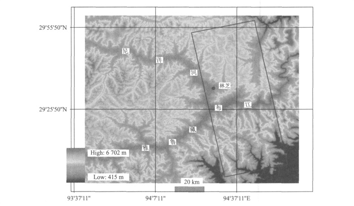
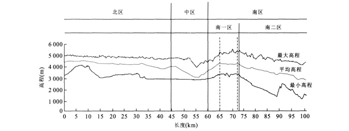
In this paper, we take new SRTM-DEM data for digital elevation analysis, field surveying and chronology of sediments as means to study topographic features and its origin in the great canyon region of Yalung Zangbo River in Tibet.The new SRTM-DEM data are used for quantitative analysis for terrain.The overall geomorphic features are the high-altitude, high-relief and flat peaks (North).ArcGIS software, an analysis platform, is used to obtain statistics for Maximum-Mean-Minimum elevation profiles from a strip area in its SRTM-DEM.These profiles show that the change of Mean elevation is controlled by the change of Maximum elevation.Incision depth of different geological units can be calculated by Max and Min elevation profiles.Sediments in valleys include moraines and icy lake sediments formatted after late Pleistocene which is confirmed by our field investigation and chronological data of sediments.To sum up, glacier, drainage network incision and outflow drainage system control the geomorphology in the great canyon region of Yalungzangbo River during the cause of terrain formation.The Glacier on the high mountain is an important external factor that controls 'unroofing'.Drainage network incision and erosion play an important role of relief terrain.Due to the fact that basin filling is limited by outflow drainage system, not only deposits in moraines but also icy lake sediments in valleys are younger.
In this paper, we take new SRTM-DEM data for digital elevation analysis, field surveying and chronology of sediments as means to study topographic features and its origin in the great canyon region of Yalung Zangbo River in Tibet.The new SRTM-DEM data are used for quantitative analysis for terrain.The overall geomorphic features are the high-altitude, high-relief and flat peaks (North).ArcGIS software, an analysis platform, is used to obtain statistics for Maximum-Mean-Minimum elevation profiles from a strip area in its SRTM-DEM.These profiles show that the change of Mean elevation is controlled by the change of Maximum elevation.Incision depth of different geological units can be calculated by Max and Min elevation profiles.Sediments in valleys include moraines and icy lake sediments formatted after late Pleistocene which is confirmed by our field investigation and chronological data of sediments.To sum up, glacier, drainage network incision and outflow drainage system control the geomorphology in the great canyon region of Yalungzangbo River during the cause of terrain formation.The Glacier on the high mountain is an important external factor that controls 'unroofing'.Drainage network incision and erosion play an important role of relief terrain.Due to the fact that basin filling is limited by outflow drainage system, not only deposits in moraines but also icy lake sediments in valleys are younger.

2009, 34(4): 604-612.
Abstract:
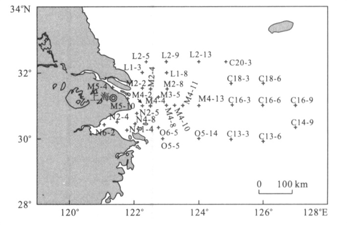
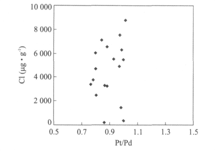
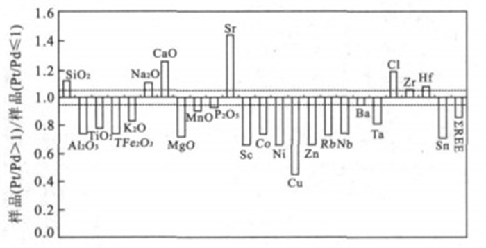
Over the past decades extensive studies on the sediment source tracing and transporting routine of Yellow Sea and East China Sea have been carried out but not yet resolved completely.The present research suggests Pt/Pd ratio is a promising index to distinguish sediments transported from Changjiang and those from Huanghe drainage basins.The erosive sediment of old Huanghe Delta transported by southern Yellow Sea coastal current is characterized by Pt/Pd > 1;land source sediment carried by Changjiang River was characterized by Pt/Pd≤1.The two unique weathering regime in the Chanjiang and Huanghe drainage basins was the key factor causing the fractionation of Pt and Pd in the sediment.The element composition in the sediment of Pt/Pd≤1 corresponds well with that of Changjiang sediments, and the element composition in the sediment of Pt/Pd≤1 is in accordance with that of Huanghe sediments.The K/Na-Rb/Sr diagram suggests that the chemical composition of land source sediment varied during re-erosion and re-transportion and re-sedimentation.
Over the past decades extensive studies on the sediment source tracing and transporting routine of Yellow Sea and East China Sea have been carried out but not yet resolved completely.The present research suggests Pt/Pd ratio is a promising index to distinguish sediments transported from Changjiang and those from Huanghe drainage basins.The erosive sediment of old Huanghe Delta transported by southern Yellow Sea coastal current is characterized by Pt/Pd > 1;land source sediment carried by Changjiang River was characterized by Pt/Pd≤1.The two unique weathering regime in the Chanjiang and Huanghe drainage basins was the key factor causing the fractionation of Pt and Pd in the sediment.The element composition in the sediment of Pt/Pd≤1 corresponds well with that of Changjiang sediments, and the element composition in the sediment of Pt/Pd≤1 is in accordance with that of Huanghe sediments.The K/Na-Rb/Sr diagram suggests that the chemical composition of land source sediment varied during re-erosion and re-transportion and re-sedimentation.


2009, 34(4): 613-622.
Abstract:
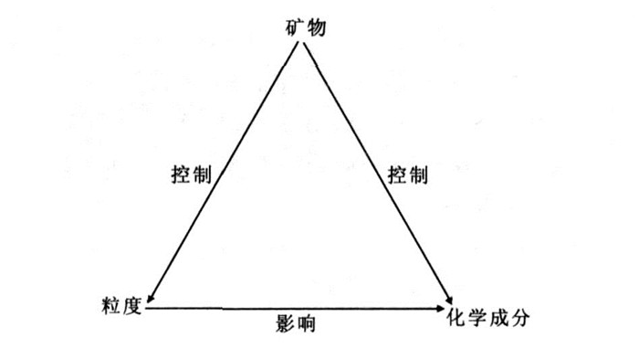
The grain-size distribution, geochemical compositions and terrigenous mineral components of sediments of Core EC2005 in the inner shelf of the East China Sea (ECS) are analyzed to probe into their possible inherent relationships.Terrigenous components in Core EC2005 are dominated by clay minerals, quartz and feldspar.The variation of mean grain size of the downhole is mainly controlled by the quartz and feldspar content.The mineral components show good correlation to geochemical compositions, suggesting the mineral constrains on the chemical elements in the sediments.Our study shows that the grain-size and the geochemical composition of terrigenous mineral particles are the main factors that control the grain-size parameters and geochemical composition of sediments.The mineral constrains on the grain-size distribution and geochemical composition are crucial, whereas the grain-size distribution can only affect the geochemical composition via changes in mineral components.
The grain-size distribution, geochemical compositions and terrigenous mineral components of sediments of Core EC2005 in the inner shelf of the East China Sea (ECS) are analyzed to probe into their possible inherent relationships.Terrigenous components in Core EC2005 are dominated by clay minerals, quartz and feldspar.The variation of mean grain size of the downhole is mainly controlled by the quartz and feldspar content.The mineral components show good correlation to geochemical compositions, suggesting the mineral constrains on the chemical elements in the sediments.Our study shows that the grain-size and the geochemical composition of terrigenous mineral particles are the main factors that control the grain-size parameters and geochemical composition of sediments.The mineral constrains on the grain-size distribution and geochemical composition are crucial, whereas the grain-size distribution can only affect the geochemical composition via changes in mineral components.


2009, 34(4): 623-628.
Abstract:
Variety of molecular fossils in red paleosols can provide direct evidence for paleoecological origin of red paleosols, but the popularization and application of the traditional Soxhlet extraction are limited by low content of molecular fossils in vermicular red paleosols.The alkaline hydrolytic method is tentatively employed to extract lipids from Pleistocene vermicular red paleosols in Xuancheng, Anhui Province.Relatively high content and variety of organics have been detected in two samples with weight of 25 g, respectively.The effect of pollution reducing is also obvious in contrast to Soxhlet extraction, which will be potential for the research on some geological sediment with low content of organic matter (such as red paleosols).A new kind of lipid biomarker named as dicarboxyl acids is firstly found in red paleosols due to alkaline hydrolytic method.In addition, other compounds extracted by traditional Soxhlet extraction such as n-alkanes, fatty acids, n-alkanols are also detected.The occurrence of dicarboxyl acids has put new insight into understanding that red paleosols is possibly developed under excessively humid condition.Distribution pattern of molecular fossils in testing samples demonstrates that the organics of red paleosols mainly originate from microbe and shows that the formation of red paleosols is affected by microbial activities with lots of oganic matter from lower bacteria and algae.The results of our preliminary studying have provided new evidence for the research on the formation environment of red paleosols.
Variety of molecular fossils in red paleosols can provide direct evidence for paleoecological origin of red paleosols, but the popularization and application of the traditional Soxhlet extraction are limited by low content of molecular fossils in vermicular red paleosols.The alkaline hydrolytic method is tentatively employed to extract lipids from Pleistocene vermicular red paleosols in Xuancheng, Anhui Province.Relatively high content and variety of organics have been detected in two samples with weight of 25 g, respectively.The effect of pollution reducing is also obvious in contrast to Soxhlet extraction, which will be potential for the research on some geological sediment with low content of organic matter (such as red paleosols).A new kind of lipid biomarker named as dicarboxyl acids is firstly found in red paleosols due to alkaline hydrolytic method.In addition, other compounds extracted by traditional Soxhlet extraction such as n-alkanes, fatty acids, n-alkanols are also detected.The occurrence of dicarboxyl acids has put new insight into understanding that red paleosols is possibly developed under excessively humid condition.Distribution pattern of molecular fossils in testing samples demonstrates that the organics of red paleosols mainly originate from microbe and shows that the formation of red paleosols is affected by microbial activities with lots of oganic matter from lower bacteria and algae.The results of our preliminary studying have provided new evidence for the research on the formation environment of red paleosols.


2009, 34(4): 629-634.
Abstract:
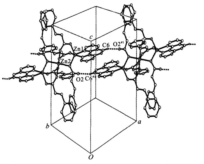
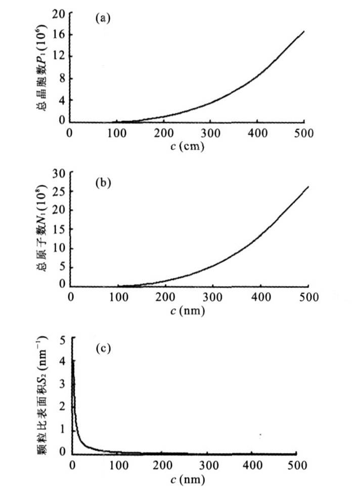
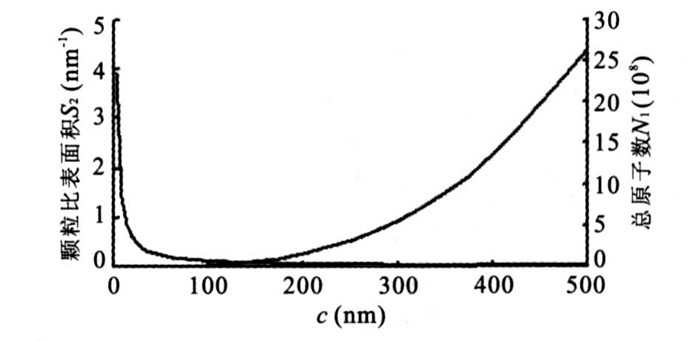
The complex Zn3 (PhCH=CHCOO) 6 (phen) 2·H2O is a new environmental mineral.Its micro-structure is similar to that of manganese oxide and manganese hydroxide.The formation environment and micro-crystal structure have obvious environmental attribute.In order to investigate the nano-crystal structure, the optimum dimension, and the environment significance, we used the nano-crystal calculation method on the basis of the crystal structure of the title compound to discuss the crystal cell numbers, the atomicity, the surface layer atomicity and its proportion.By comparing the structure of manganese oxide and manganese hydroxide with the compound, we discuss its environmental attribute.It is found that the activity of the compound and surface effects are closely related with the particle size, and its inherence structure has obvious environmental attribute.Finally, we theoretically carry on the computation discussion to turning compounds into nanometer particle.The optimum dimension of its nano-particle is theoretically determined to be about 138 nm.
The complex Zn3 (PhCH=CHCOO) 6 (phen) 2·H2O is a new environmental mineral.Its micro-structure is similar to that of manganese oxide and manganese hydroxide.The formation environment and micro-crystal structure have obvious environmental attribute.In order to investigate the nano-crystal structure, the optimum dimension, and the environment significance, we used the nano-crystal calculation method on the basis of the crystal structure of the title compound to discuss the crystal cell numbers, the atomicity, the surface layer atomicity and its proportion.By comparing the structure of manganese oxide and manganese hydroxide with the compound, we discuss its environmental attribute.It is found that the activity of the compound and surface effects are closely related with the particle size, and its inherence structure has obvious environmental attribute.Finally, we theoretically carry on the computation discussion to turning compounds into nanometer particle.The optimum dimension of its nano-particle is theoretically determined to be about 138 nm.


2009, 34(4): 635-640.
Abstract:
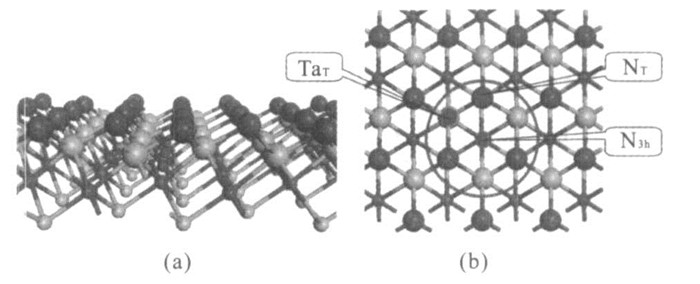
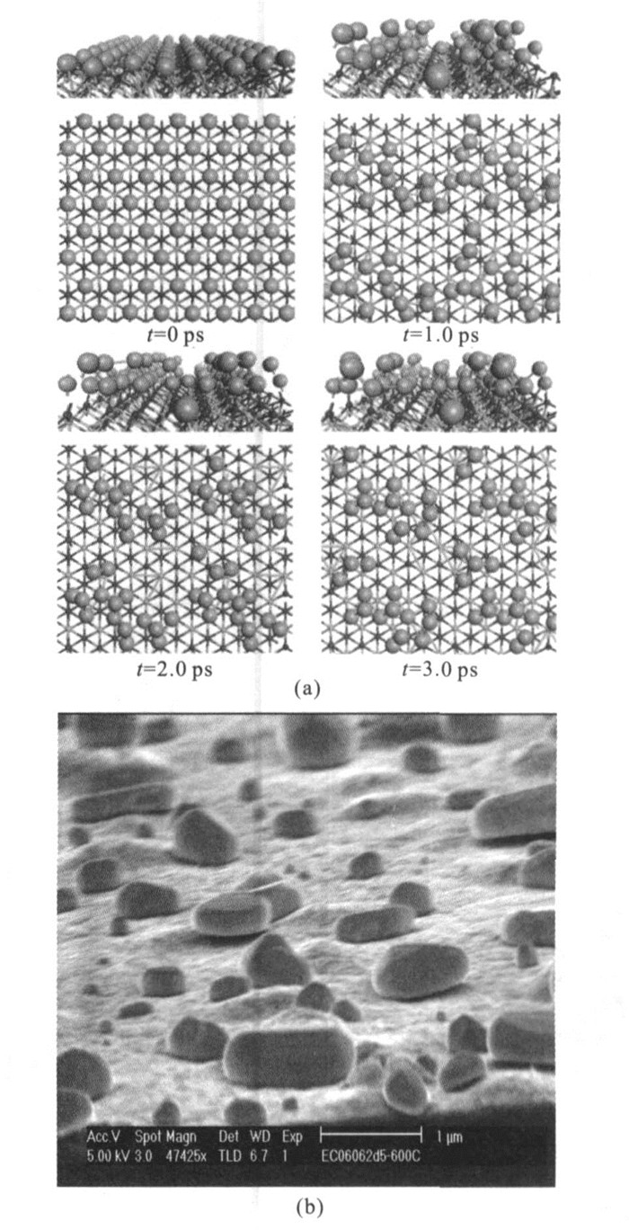
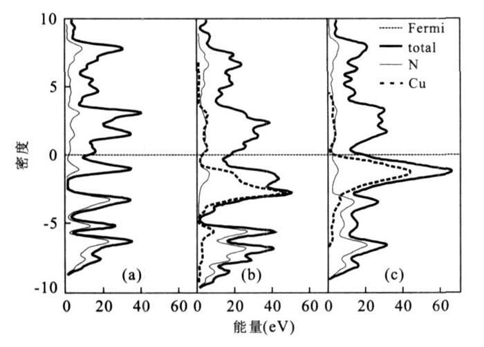
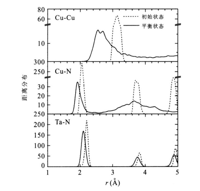
Cu seed layer agglomeration on barriers is a bottleneck in semiconductor industry for the application of atomic layer deposition (ALD) which is the preferred technology for the next-generation ultra large-scale integrated circuit (ULSC).However, the theoretical understanding of the underlying mechanisms of Cu aggregation is still not clearly known.We made a first-principles study of copper aggregation on the TaN (111) surface, using density functional theory.The adsorption energies and charge transfers were evaluated to address the interactions between Cu and the substrate.Ab initio molecular dynamics simulations were performed to examine the dynamic behavior of a copper monolayer originally commensurate with the TaN substrate at the typical atomic layer deposition (ALD) operating temperature (500 K).The results revealed that the copper film underwent substantial agglomeration on the TaN (111) surface at this ALD operating temperature, which was consistent with experimental observations.
Cu seed layer agglomeration on barriers is a bottleneck in semiconductor industry for the application of atomic layer deposition (ALD) which is the preferred technology for the next-generation ultra large-scale integrated circuit (ULSC).However, the theoretical understanding of the underlying mechanisms of Cu aggregation is still not clearly known.We made a first-principles study of copper aggregation on the TaN (111) surface, using density functional theory.The adsorption energies and charge transfers were evaluated to address the interactions between Cu and the substrate.Ab initio molecular dynamics simulations were performed to examine the dynamic behavior of a copper monolayer originally commensurate with the TaN substrate at the typical atomic layer deposition (ALD) operating temperature (500 K).The results revealed that the copper film underwent substantial agglomeration on the TaN (111) surface at this ALD operating temperature, which was consistent with experimental observations.
2009, 34(4): 641-650.
Abstract:
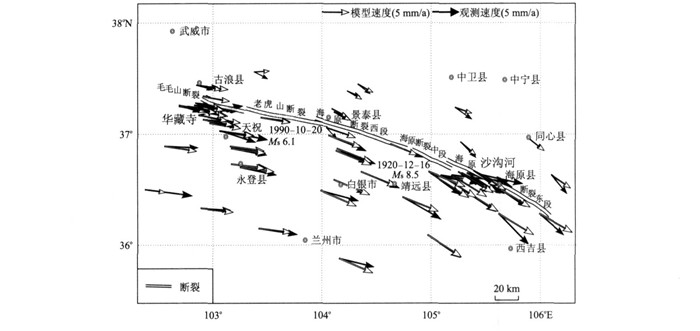
We caculate Coulomb stress accumulation rate and moment accumulation rate through inversing Haiyuan fault slipping rates and locking depths by using a Fourier solution of 3D body force model with constrains of CMONOC and GPS profiles data.Genetic algorithm has been applied to simulate the GPS velocity field.The last fitting rms residual is 1.2 mm/a.The result reveals that the slip rate of left lateral of Maomao Shan fault is 3.6 mm/a, and 22.2 km for the locking depth.For Laohushan, its slip rate is 10.5 mm/a and 11.4 km for locking depth.The slip rate in western segment, middle segment and eastern segment of Haiyuan fault (in narrow sense) is respectively 3.5 mm/a, 5.8 mm/a and 5.7 mm/a, and 8.5 km, 3.6 km and 4.3 km for the locking depth.The Coulomb stress accumulation rates are 0.48~1.59 MPa/100 a along Haiyuan fault zone.The Coulomb stress accumulation rate is large but the moment accumulation rate is small in Maomaoshan fault.In Laohushan fault both the Coulomb stress accumulation rate and moment accumulation rate are large.The Coulomb stress accumulation rates in the middle and western segments of Haiyuan fault (in narrow sense) are largest in all segments.
We caculate Coulomb stress accumulation rate and moment accumulation rate through inversing Haiyuan fault slipping rates and locking depths by using a Fourier solution of 3D body force model with constrains of CMONOC and GPS profiles data.Genetic algorithm has been applied to simulate the GPS velocity field.The last fitting rms residual is 1.2 mm/a.The result reveals that the slip rate of left lateral of Maomao Shan fault is 3.6 mm/a, and 22.2 km for the locking depth.For Laohushan, its slip rate is 10.5 mm/a and 11.4 km for locking depth.The slip rate in western segment, middle segment and eastern segment of Haiyuan fault (in narrow sense) is respectively 3.5 mm/a, 5.8 mm/a and 5.7 mm/a, and 8.5 km, 3.6 km and 4.3 km for the locking depth.The Coulomb stress accumulation rates are 0.48~1.59 MPa/100 a along Haiyuan fault zone.The Coulomb stress accumulation rate is large but the moment accumulation rate is small in Maomaoshan fault.In Laohushan fault both the Coulomb stress accumulation rate and moment accumulation rate are large.The Coulomb stress accumulation rates in the middle and western segments of Haiyuan fault (in narrow sense) are largest in all segments.


2009, 34(4): 651-657.
Abstract:
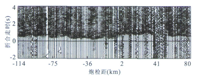
The structure of crust and upper mantle in Tianshui-Wudu strong earthquake region is studied by using DSS data from two cross high resolution refraction /wide angle reflection profiles and corresponding fan profiles.The 2-D result shows that the crust can be vertically divided into two layers: upper crust and lower crust.There exists a low velocity layer in the upper crust with velocity difference of 0.3-0.5 km/s.The depth of Moho is about 46-48 km.There is a strong lateral variation in the lower crust along the NE Tianshui-Wudu profile.And along the NW Chengxian-Wushan profile, there are some evidences showing that the Moho and C discontinuities are changed by substances from the deep layer.The 3-D result shows that there is a fault with near NS strike at the depth of 7-11 km near 105°E.The velocities at the two sides of this fault are quite different: low velocity at the west side and high velocity at the east side.This NS fault is very close to the deep fault of 2-D profile.All the large earthquakes occurred near 105°E and formed a NS belt.
The structure of crust and upper mantle in Tianshui-Wudu strong earthquake region is studied by using DSS data from two cross high resolution refraction /wide angle reflection profiles and corresponding fan profiles.The 2-D result shows that the crust can be vertically divided into two layers: upper crust and lower crust.There exists a low velocity layer in the upper crust with velocity difference of 0.3-0.5 km/s.The depth of Moho is about 46-48 km.There is a strong lateral variation in the lower crust along the NE Tianshui-Wudu profile.And along the NW Chengxian-Wushan profile, there are some evidences showing that the Moho and C discontinuities are changed by substances from the deep layer.The 3-D result shows that there is a fault with near NS strike at the depth of 7-11 km near 105°E.The velocities at the two sides of this fault are quite different: low velocity at the west side and high velocity at the east side.This NS fault is very close to the deep fault of 2-D profile.All the large earthquakes occurred near 105°E and formed a NS belt.


2009, 34(4): 658-664.
Abstract:
In finite-difference time-domain modeling of elastic waves, absorbing boundary conditions are used to mitigate undesired reflections from the model's truncation boundaries.The perfectly matched layer (PML) is generally acknowledged as the best available absorbing boundary condition and very efficient to absorb both body waves and surface waves.The classical splitting PML (SPML) has some disadvantages: it needs much computer memory and has complex programming process.And the conventional non-splitting PML (NPML) based on time convolution needs more auxiliary equations or fields and computing time.We have induced a simple and efficient NPML based on non-convolution technology in this paper.The NPML we induced does not have to split the velocity and stress fields and also doesn't need to involve in complex convolution in time domain.The analysis result shows the new PML method not only has perfect absorbing performance, but also has simple computing equations, easier programming and less memory consumption.
In finite-difference time-domain modeling of elastic waves, absorbing boundary conditions are used to mitigate undesired reflections from the model's truncation boundaries.The perfectly matched layer (PML) is generally acknowledged as the best available absorbing boundary condition and very efficient to absorb both body waves and surface waves.The classical splitting PML (SPML) has some disadvantages: it needs much computer memory and has complex programming process.And the conventional non-splitting PML (NPML) based on time convolution needs more auxiliary equations or fields and computing time.We have induced a simple and efficient NPML based on non-convolution technology in this paper.The NPML we induced does not have to split the velocity and stress fields and also doesn't need to involve in complex convolution in time domain.The analysis result shows the new PML method not only has perfect absorbing performance, but also has simple computing equations, easier programming and less memory consumption.


2009, 34(4): 665-672.
Abstract:
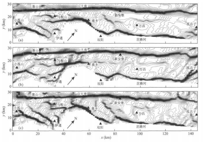
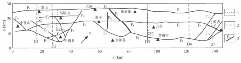
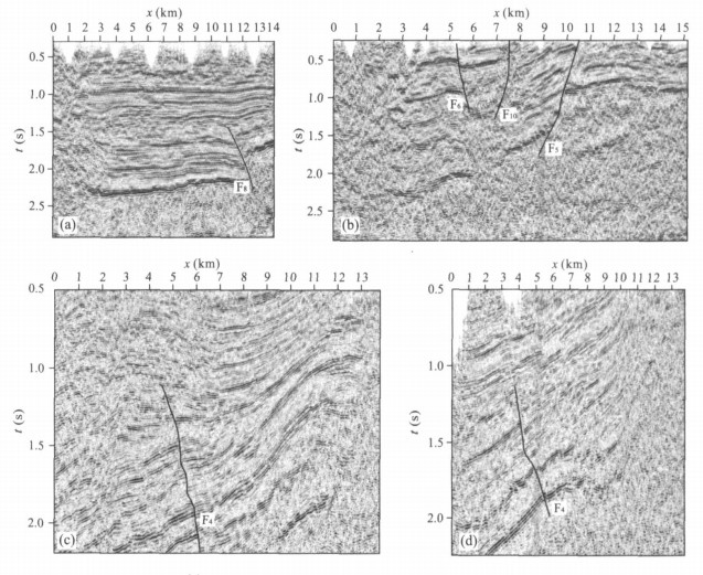
The predecessors mainly researched properties of boundary faults and secondary fault of the faulted system in Yitong basin.In order to explain the characteristics of other faults in this basin, the paper obtains the locations of 14 faults, rebuilds faulted structure pattern curve of this basin and describes the charateristics of gravity field of main faults using the techniques of small subdomain filtering and three-directional small subdomain filtering.The comparison with other physical geography data (4 seismic profiles and 4 electrical resistivity sections) proves that the new found faults by the three-directional small subdomain filtering are existent and ensures that the techniques used in this paper are valid.In the paper, we expatiate on the characteristics of 14 faults and mainly study the existence and property of mid-faults.The mid-faults with boundary faults of this basin are main faulted structure that controls the whole basin and formed in geologic epoch.The secondary faulted structure joints Xilamulun faulted structure and the basal of the south part of this basin (the south of the secondary fault) is related to Huabei plate, while the north of it is compound basal of Dongbei small plates.
The predecessors mainly researched properties of boundary faults and secondary fault of the faulted system in Yitong basin.In order to explain the characteristics of other faults in this basin, the paper obtains the locations of 14 faults, rebuilds faulted structure pattern curve of this basin and describes the charateristics of gravity field of main faults using the techniques of small subdomain filtering and three-directional small subdomain filtering.The comparison with other physical geography data (4 seismic profiles and 4 electrical resistivity sections) proves that the new found faults by the three-directional small subdomain filtering are existent and ensures that the techniques used in this paper are valid.In the paper, we expatiate on the characteristics of 14 faults and mainly study the existence and property of mid-faults.The mid-faults with boundary faults of this basin are main faulted structure that controls the whole basin and formed in geologic epoch.The secondary faulted structure joints Xilamulun faulted structure and the basal of the south part of this basin (the south of the secondary fault) is related to Huabei plate, while the north of it is compound basal of Dongbei small plates.


2009, 34(4): 673-681.
Abstract:
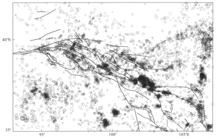
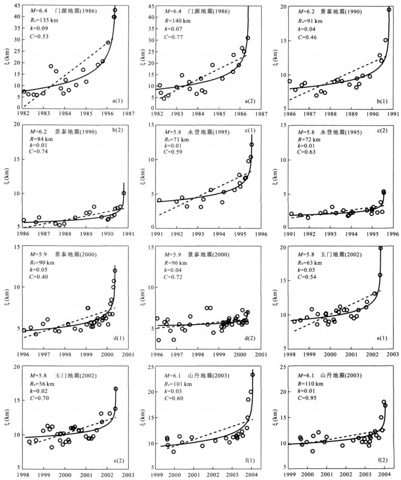
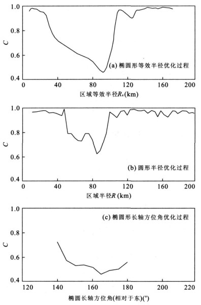
For studying the characteristics of seismic correlation length before great earthquakes, the temporal-spatial change of seismicity prior to 6 moderate strong earthquakes (ML>5. 5) in the boundaries along the northeast margin of Tibet block have been analyzed. We use ellipse, whose long axis is coincident with the strike of main fault belt in the source area, as the spatial window to analyze growing correlation length prior to main-shock and design the corresponding optimization procedure. Comparison between the results from elliptical and circular spatial windows shows that the growing correlation length prior to 6 moderate strong earthquakes studied have been observed in both two spatial windows. The results from ellipse are better than that from circular, and the growth ranges of correlation length in former are larger than those in later yet the smaller curvature parameter values of C are obtained in elliptical spatial windows. Three types of random synthetic catalog are used to test the significance of the results. The results reject the null hypothesis for three types of random synthetic catalog and show that the observed patterns are not consequences of random fluctuations. That theory is found to be of above 99% confidence levels. The scaling relation we found, log Re~0.46 M between the main-shock magnitude M and the equivalent radius Re of the critical region is in good agreement with theoretical values.
For studying the characteristics of seismic correlation length before great earthquakes, the temporal-spatial change of seismicity prior to 6 moderate strong earthquakes (ML>5. 5) in the boundaries along the northeast margin of Tibet block have been analyzed. We use ellipse, whose long axis is coincident with the strike of main fault belt in the source area, as the spatial window to analyze growing correlation length prior to main-shock and design the corresponding optimization procedure. Comparison between the results from elliptical and circular spatial windows shows that the growing correlation length prior to 6 moderate strong earthquakes studied have been observed in both two spatial windows. The results from ellipse are better than that from circular, and the growth ranges of correlation length in former are larger than those in later yet the smaller curvature parameter values of C are obtained in elliptical spatial windows. Three types of random synthetic catalog are used to test the significance of the results. The results reject the null hypothesis for three types of random synthetic catalog and show that the observed patterns are not consequences of random fluctuations. That theory is found to be of above 99% confidence levels. The scaling relation we found, log Re~0.46 M between the main-shock magnitude M and the equivalent radius Re of the critical region is in good agreement with theoretical values.


2009, 34(4): 682-690.
Abstract:
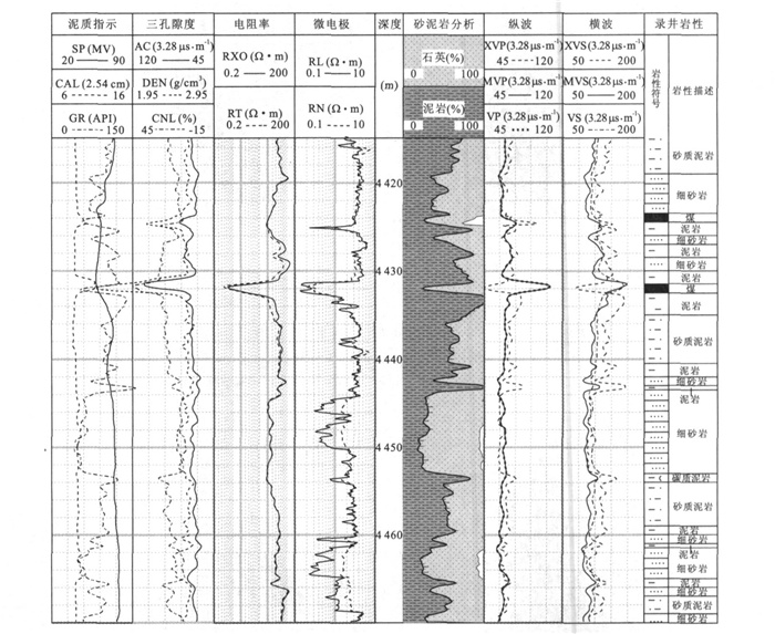
In this paper we propose a genetic algorithm for optimal stratigraphical division using multi-parameter well-log data.The algorithm incorporates the Fisher optimal division and edge detection methods into genetic searching in order to find out rapidly from a well a group of division boundaries that satisfy an optimization criterion.The optimization criterion involves the following steps: After a well (or a segment of it) is divided into a group of subsections, the total in-subsection deviation of the multi-parameter log data is minimized.Then the total inter-subsection deviation of the data is maximized, and the boundary points are to the largest extent singular points in log curves.This criterion is used to formulate the fitness function in our genetic algorithm.In the algorithm, logging measurement points are taken as genes, and groups of ordered measurement points as chromosomes; Genetic strategies of tournament selection, catastrophic mutation, Monte Carlo sampling crossover, and elitist reservation are adopted.We test the method on a geologically well-studied well which penetrates the deep-buried Mesozoic strata in Jiyang depression, Shandong, China.It is shown that, using log data alone, our method obtains stratigrahic division results that are geologically sound.Meanwhile the method proves far faster than an ordinary Fisher optimal division method in computation.We conclude that our method is highly applicable in statratigraphic division studies in areas such as Jiyang depression, where the interested strata is deep-buried, with scarce relevant well cores, poor seismic resolution, and abundant log data.
In this paper we propose a genetic algorithm for optimal stratigraphical division using multi-parameter well-log data.The algorithm incorporates the Fisher optimal division and edge detection methods into genetic searching in order to find out rapidly from a well a group of division boundaries that satisfy an optimization criterion.The optimization criterion involves the following steps: After a well (or a segment of it) is divided into a group of subsections, the total in-subsection deviation of the multi-parameter log data is minimized.Then the total inter-subsection deviation of the data is maximized, and the boundary points are to the largest extent singular points in log curves.This criterion is used to formulate the fitness function in our genetic algorithm.In the algorithm, logging measurement points are taken as genes, and groups of ordered measurement points as chromosomes; Genetic strategies of tournament selection, catastrophic mutation, Monte Carlo sampling crossover, and elitist reservation are adopted.We test the method on a geologically well-studied well which penetrates the deep-buried Mesozoic strata in Jiyang depression, Shandong, China.It is shown that, using log data alone, our method obtains stratigrahic division results that are geologically sound.Meanwhile the method proves far faster than an ordinary Fisher optimal division method in computation.We conclude that our method is highly applicable in statratigraphic division studies in areas such as Jiyang depression, where the interested strata is deep-buried, with scarce relevant well cores, poor seismic resolution, and abundant log data.


2009, 34(4): 691-698.
Abstract:
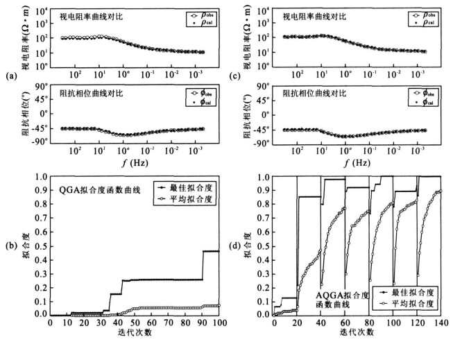
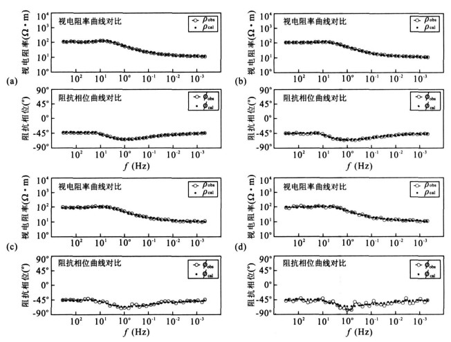
This paper applied the conventional quantum genetic algorithm (QGA) to solve the nonlinear magnetotelluric inverse problem of layered model.However, the conventional QGA shows a premature convergence problem throughout our numerical experiments.In order to overcome the shortcoming of premature convergence, we improved the conventional QGA with automatically adjusting the size of model space with different scales, and eventually developed a novel method, referred as to adaptive quantum genetic algorithm (AQGA), for the inversion of magnetotelluric data.The validity of AQGA method is demonstrated by some optimization test functions and synthetic magnetotelluric models.The results show that AQGA mitigate the premature convergence and improve the efficiency and accuracy of inverted models.The obtained models using AQGA for magnetotelluric field data are well agreed with geological structure, which inferred that the improved AQGA method is powerful for the nonlinear optimization problem.
This paper applied the conventional quantum genetic algorithm (QGA) to solve the nonlinear magnetotelluric inverse problem of layered model.However, the conventional QGA shows a premature convergence problem throughout our numerical experiments.In order to overcome the shortcoming of premature convergence, we improved the conventional QGA with automatically adjusting the size of model space with different scales, and eventually developed a novel method, referred as to adaptive quantum genetic algorithm (AQGA), for the inversion of magnetotelluric data.The validity of AQGA method is demonstrated by some optimization test functions and synthetic magnetotelluric models.The results show that AQGA mitigate the premature convergence and improve the efficiency and accuracy of inverted models.The obtained models using AQGA for magnetotelluric field data are well agreed with geological structure, which inferred that the improved AQGA method is powerful for the nonlinear optimization problem.


2009, 34(4): 699-707.
Abstract:
The shear wave velocity of well log is an important parameter for mutual inversion, but lots of wells are short of this value.As present estimation method can't calculate the shear velocity precisely, based on rock physics, using VRH model this paper firstly calculates the equivalent elastic modulus via multi-mineral analysis from routine well logs, and then by taking compressional velocity as a constraint, calculates the shear wave velocity based on Biot-Gassmann equations.The method has clearer physics meaning, and practice results show that this method is much more convenient, economic and precise than Xu-White methods, and the error between computational value and measured value is less than 5 percent.
The shear wave velocity of well log is an important parameter for mutual inversion, but lots of wells are short of this value.As present estimation method can't calculate the shear velocity precisely, based on rock physics, using VRH model this paper firstly calculates the equivalent elastic modulus via multi-mineral analysis from routine well logs, and then by taking compressional velocity as a constraint, calculates the shear wave velocity based on Biot-Gassmann equations.The method has clearer physics meaning, and practice results show that this method is much more convenient, economic and precise than Xu-White methods, and the error between computational value and measured value is less than 5 percent.


2009, 34(4): 708-716.
Abstract:
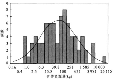
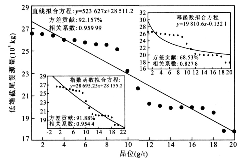
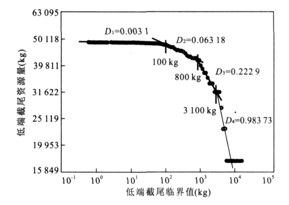
Dashui gold deposit boasts its superlarge size.Based on the previous geological research, the quantitative regulation of resource growth has been revealed by studying the multifractals and grade-tonnage relation from geological data of ore-bodies.The ore-body lengths are subjected to single fractal distribution, while tonnages vs grades relation can be better fitted to the exponential function or linear function.With the multifractal characteristics of double-logarithmic chart of tonnages vs grades and tonnage vs orebody resources, all the above show that, in the fractal metallogenic structure space, the growth of mineral resources in specific metallogenic phase was a nonlinear proliferation process related to self-organized optimization and its random makes the relation of tonnage vs grades tend to be exponential function, and the whole metallogenic process was the linear addition of multi-phase ore-body resources.Furthermore, the tonnage vs grade equations consistent with statistics were found by the maximal entropy and the utility theory and verified by the orebody geological data of Chaijiazhuang gold deposit.
Dashui gold deposit boasts its superlarge size.Based on the previous geological research, the quantitative regulation of resource growth has been revealed by studying the multifractals and grade-tonnage relation from geological data of ore-bodies.The ore-body lengths are subjected to single fractal distribution, while tonnages vs grades relation can be better fitted to the exponential function or linear function.With the multifractal characteristics of double-logarithmic chart of tonnages vs grades and tonnage vs orebody resources, all the above show that, in the fractal metallogenic structure space, the growth of mineral resources in specific metallogenic phase was a nonlinear proliferation process related to self-organized optimization and its random makes the relation of tonnage vs grades tend to be exponential function, and the whole metallogenic process was the linear addition of multi-phase ore-body resources.Furthermore, the tonnage vs grade equations consistent with statistics were found by the maximal entropy and the utility theory and verified by the orebody geological data of Chaijiazhuang gold deposit.