


2010 Vol. 35, No. 2
Display Method:
2010, 35(2): 161-174.
doi: 10.3799/dqkx.2010.017
 PDF 1218KB
Abstract:
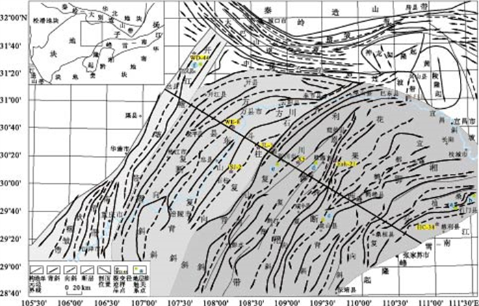
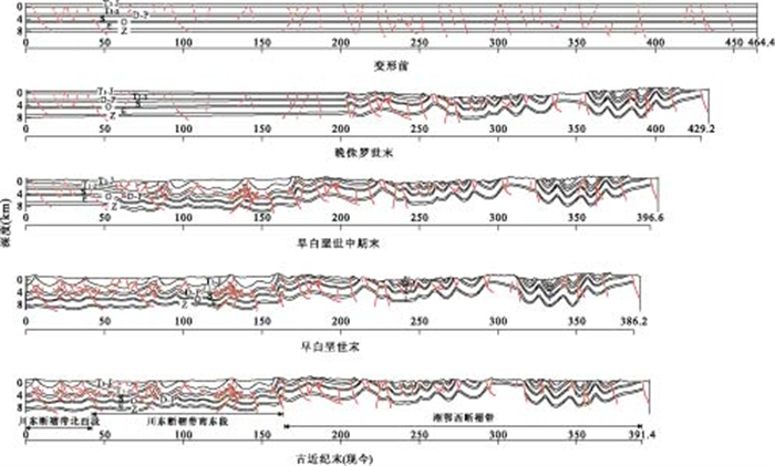
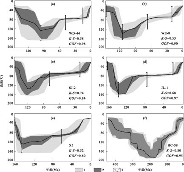
The Mesozoic intra-continental evolution of about 400 km wide middle-upper Yangtze thrust belt from western Hunan-Hubei-eastern Sichuan provinces has been established with a time interval of 70 Ma (from 165 Ma to 95 Ma). Based on apatite fission track (AFT), time-temperature thermal history and balanced cross-section, we conclude that the deformation evolution is progressive from southeast (Jiangnan-Xuefeng intra-continental orogeny) to northwest (Huayingshan thrust belt), and younger and younger. The shortening of thick-skinned fault-fold zone in western Hunan Province-Hubei Province is less than that of thin-skinned fault-fold zone in east Sichuan Province. The shortening rate of the fault-fold zone in western Hunan Province-Hubei Province during Jurassic is obviously more than that of the southeast region of the fault-fold zone of eastern Sichuan Province during the early and middle periods of Early Crataceous. And the shortening rate of the southeast region of the fault-fold zone of eastern Sichuan Province during the early and middle periods of Early Crataceous is more than that of the northwest region of the fault-fold zone of eastern Sichuan Province during the late periods of Early Crataceous. The differences of the shortening rates in the different zones are controlled by the basement and the strength of the compressional deformation. These results indicate that Mesozoic intra-continental deformation in western Hunan Province-Hubei Province to eastern Sichuan Province is progressive with a large width and a long diachronous interval. Because of the different basement, basement involvement level and participation level of detachment layer, the differences of shorterning and shortening rates reflect the obvious differences of intra-continental deformation and its dynamics. The "driving engine" of Mesozoic intra-continental progressive deformation is speculated to be in Taoyuan-Huaihua area, if the Jiangnan-Xuefeng uplift is in place or parautochthon. The Taoyuan-Huaihua area is also where the Jiangnan-Xuefeng Mesozoic intra-continental orogenesis began and expanded southward and northward with a flower-structure geometry.
The Mesozoic intra-continental evolution of about 400 km wide middle-upper Yangtze thrust belt from western Hunan-Hubei-eastern Sichuan provinces has been established with a time interval of 70 Ma (from 165 Ma to 95 Ma). Based on apatite fission track (AFT), time-temperature thermal history and balanced cross-section, we conclude that the deformation evolution is progressive from southeast (Jiangnan-Xuefeng intra-continental orogeny) to northwest (Huayingshan thrust belt), and younger and younger. The shortening of thick-skinned fault-fold zone in western Hunan Province-Hubei Province is less than that of thin-skinned fault-fold zone in east Sichuan Province. The shortening rate of the fault-fold zone in western Hunan Province-Hubei Province during Jurassic is obviously more than that of the southeast region of the fault-fold zone of eastern Sichuan Province during the early and middle periods of Early Crataceous. And the shortening rate of the southeast region of the fault-fold zone of eastern Sichuan Province during the early and middle periods of Early Crataceous is more than that of the northwest region of the fault-fold zone of eastern Sichuan Province during the late periods of Early Crataceous. The differences of the shortening rates in the different zones are controlled by the basement and the strength of the compressional deformation. These results indicate that Mesozoic intra-continental deformation in western Hunan Province-Hubei Province to eastern Sichuan Province is progressive with a large width and a long diachronous interval. Because of the different basement, basement involvement level and participation level of detachment layer, the differences of shorterning and shortening rates reflect the obvious differences of intra-continental deformation and its dynamics. The "driving engine" of Mesozoic intra-continental progressive deformation is speculated to be in Taoyuan-Huaihua area, if the Jiangnan-Xuefeng uplift is in place or parautochthon. The Taoyuan-Huaihua area is also where the Jiangnan-Xuefeng Mesozoic intra-continental orogenesis began and expanded southward and northward with a flower-structure geometry.


2010, 35(2): 175-185.
doi: 10.3799/dqkx.2010.018
Abstract:
The dating of LA-ICP-MS zircon U-Pb was carried out for granodiorite porphyries at Dabaoshan polymetallic ore deposit in North Guangdong Province. In cathodoluminescence (CL) image, most zircons in two granodiorite porphyry samples exhibit oscillatory zoning, which is typical for magmatic zircon. The dating of LA-ICP-MS zircon U-Pb of two samples shows the results that 12 points of oscillatory zoned domains of Dabaoshan granodiorite porphyry sample yields a group of weighted mean 206Pb/238U ages at (175.8±1.5)Ma (MSWD=0.037) and 16 points of oscillatory zoned domains of Chuandu granodiorite porphyry yields a group of weighted mean 206Pb/238U ages at (175.0±1.7) Ma (MSWD=0.41). So the epoch of granodiorite porphyry emplacement is nearly 175 Ma, belonging to the first stage of the early Yanshanian (180-170 Ma). According to the precise ages we have obtained, Dabaoshan and Chuandu granodiorite porphyries are a whole magamtic rock divided by the post-mineralization fault, and the faulted space is the most important direction for further exploration of Mo-W. The study, together with others, suggests that its geodynamic setting was the same as that of the near magamatic rocks, which formed in the same episode lithosphere extension event in Nanling region. In addition, we conclude that in the first stage of the early Yanshanian, some granodiorite porphyries favorable to forming Mo-W deposits have been undiscovered in Nanling region.
The dating of LA-ICP-MS zircon U-Pb was carried out for granodiorite porphyries at Dabaoshan polymetallic ore deposit in North Guangdong Province. In cathodoluminescence (CL) image, most zircons in two granodiorite porphyry samples exhibit oscillatory zoning, which is typical for magmatic zircon. The dating of LA-ICP-MS zircon U-Pb of two samples shows the results that 12 points of oscillatory zoned domains of Dabaoshan granodiorite porphyry sample yields a group of weighted mean 206Pb/238U ages at (175.8±1.5)Ma (MSWD=0.037) and 16 points of oscillatory zoned domains of Chuandu granodiorite porphyry yields a group of weighted mean 206Pb/238U ages at (175.0±1.7) Ma (MSWD=0.41). So the epoch of granodiorite porphyry emplacement is nearly 175 Ma, belonging to the first stage of the early Yanshanian (180-170 Ma). According to the precise ages we have obtained, Dabaoshan and Chuandu granodiorite porphyries are a whole magamtic rock divided by the post-mineralization fault, and the faulted space is the most important direction for further exploration of Mo-W. The study, together with others, suggests that its geodynamic setting was the same as that of the near magamatic rocks, which formed in the same episode lithosphere extension event in Nanling region. In addition, we conclude that in the first stage of the early Yanshanian, some granodiorite porphyries favorable to forming Mo-W deposits have been undiscovered in Nanling region.


2010, 35(2): 186-200.
doi: 10.3799/dqkx.2010.019
Abstract:
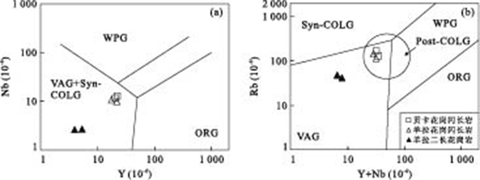
There is still much dispute over the exact subduction and collision time of Jinshajiang arc-basin system, which reveals geological evolution history of the paleo-Tethys in West China. This study provides chronological, petrological, and geochemical data of Gongka and Yangla granitoid plutons that are situated on the western margin of Jinshajiang suture zone but poorly studied in Deqin-Weixi area, Yunnan Province. The Yangla granitoid complex is divided into granodiorite and monzonite. LA-ICP-MS zircon dating results are 229.6 Ma (Yangla granodiorite), 232 Ma (Gongka granodiorite) and 261 Ma (Yangla monzonite), respectively. Yangla monzonites, showing O-adakitic affinity, was generated through partial melting of oceanic slab when subducting, probably subjected to metasomatism of the mantle wedge. Gongka granodiorites and Yangla granodiorites were derived from partial melting of lower crustal rocks. In general, we conclude that the subduction started from Middle Permian to Late Permian and the collision started in Late Permian and terminated in early Middle Triassic.
There is still much dispute over the exact subduction and collision time of Jinshajiang arc-basin system, which reveals geological evolution history of the paleo-Tethys in West China. This study provides chronological, petrological, and geochemical data of Gongka and Yangla granitoid plutons that are situated on the western margin of Jinshajiang suture zone but poorly studied in Deqin-Weixi area, Yunnan Province. The Yangla granitoid complex is divided into granodiorite and monzonite. LA-ICP-MS zircon dating results are 229.6 Ma (Yangla granodiorite), 232 Ma (Gongka granodiorite) and 261 Ma (Yangla monzonite), respectively. Yangla monzonites, showing O-adakitic affinity, was generated through partial melting of oceanic slab when subducting, probably subjected to metasomatism of the mantle wedge. Gongka granodiorites and Yangla granodiorites were derived from partial melting of lower crustal rocks. In general, we conclude that the subduction started from Middle Permian to Late Permian and the collision started in Late Permian and terminated in early Middle Triassic.


2010, 35(2): 201-210.
doi: 10.3799/dqkx.2010.020
Abstract:
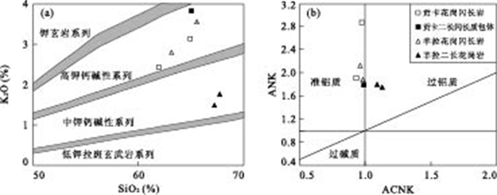
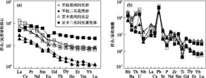
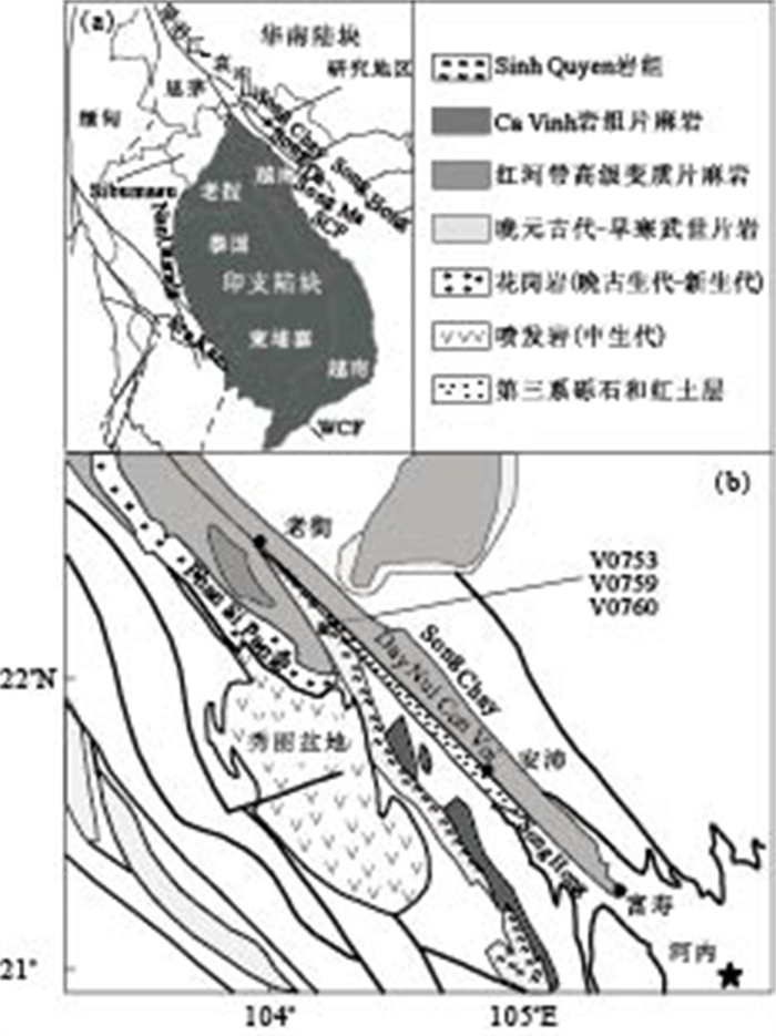
Northwestern Vietnam tectonically is an important part of the eastern Tethyan orogenic belt and this terrain has recorded the amalgamation history of the Indochina and South China blocks. Tectonic provenance of the terrain plays a key role for constraints on the location of the suture between these two blocks in NW Vietnam. In this study, detrital zircon ages of the Sinh Quyen Formation as part of the Paleo- to Meso-Proterozoic basement rocks in NW Vietnam are reported for discussion of sedimentary sources and tectonic province of the basement. The rock formation is composed mainly of felsic paragneiss and migmatite. One hundred and sixteen zircon grains separated from three felsic paragneiss samples were analyzed by the LA-ICP-MS U-Pb dating method. Results of a total of 123 analytical spots demonstrate that crystallization ages of the detrital zircons mainly cluster around ~1.8 Ga with minor ~2.2 Ga to ~3.0 Ga, indicating Paleoproterozoic basement rocks as major sedimentary sources of the Sinh Quyen Formation. Basement rocks in northwestern Vietnam are similar to old basements in South China in formation time and so it can be proposed that the Sinh Quyen Formation is of the South China affinity or originated from crustal material of the South China block. Part of detrital zircon grains record ~250 Ma metamorphic overgrowth in the rim, probably related to the collision of South China and Indochina blocks and therefore recording the paleo-Tethyan orogenic event.
Northwestern Vietnam tectonically is an important part of the eastern Tethyan orogenic belt and this terrain has recorded the amalgamation history of the Indochina and South China blocks. Tectonic provenance of the terrain plays a key role for constraints on the location of the suture between these two blocks in NW Vietnam. In this study, detrital zircon ages of the Sinh Quyen Formation as part of the Paleo- to Meso-Proterozoic basement rocks in NW Vietnam are reported for discussion of sedimentary sources and tectonic province of the basement. The rock formation is composed mainly of felsic paragneiss and migmatite. One hundred and sixteen zircon grains separated from three felsic paragneiss samples were analyzed by the LA-ICP-MS U-Pb dating method. Results of a total of 123 analytical spots demonstrate that crystallization ages of the detrital zircons mainly cluster around ~1.8 Ga with minor ~2.2 Ga to ~3.0 Ga, indicating Paleoproterozoic basement rocks as major sedimentary sources of the Sinh Quyen Formation. Basement rocks in northwestern Vietnam are similar to old basements in South China in formation time and so it can be proposed that the Sinh Quyen Formation is of the South China affinity or originated from crustal material of the South China block. Part of detrital zircon grains record ~250 Ma metamorphic overgrowth in the rim, probably related to the collision of South China and Indochina blocks and therefore recording the paleo-Tethyan orogenic event.


2010, 35(2): 211-223.
doi: 10.3799/dqkx.2010.021
Abstract:
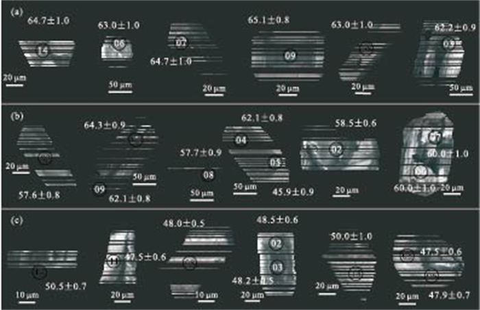
The Paleogene volcanic rock in Linzizong Group is developed in the Gangdise belt, southern Tibet plateau and it is deemed to represent the result of Neo-Tethys from its subduction to the India-Asia collision. Its precise age is significant to constrain the time of the India-Asia collision. Herein a systematic study, including zircon U-Pb ages, major and trace elements and Sr-Nd isotopic geochemistry, has been done to volcanic rock from Linzizong Group in Zhunuo area in middle Gangdise belt. We obtain Linzizong Group volcanic rock LA-ICP-MS zircon U-Pb data showing the following ages: the Dianzhong Formation, 64.8±1.6 Ma, the Nianbo Formation, 59.7±1.8 Ma, the Pana Formation, 48.9±0.8 Ma. The data of elementary and isotopic geochemistry suggest that the characteristics of these formations in Zhunuo area are similar to regional characteristics. Among them, Dianzhong and Nianbo formations are calc-alkalic and high-K calc-alkalic rocks with characteristics of arc-island volcanic rocks. Pana Formation contains shoshonite and is syn-collision volcanic rock. It is proved that suture of the Yarlung Zangbo oceanic basin and the beginning of collision between India and Asia were about 50 Ma.
The Paleogene volcanic rock in Linzizong Group is developed in the Gangdise belt, southern Tibet plateau and it is deemed to represent the result of Neo-Tethys from its subduction to the India-Asia collision. Its precise age is significant to constrain the time of the India-Asia collision. Herein a systematic study, including zircon U-Pb ages, major and trace elements and Sr-Nd isotopic geochemistry, has been done to volcanic rock from Linzizong Group in Zhunuo area in middle Gangdise belt. We obtain Linzizong Group volcanic rock LA-ICP-MS zircon U-Pb data showing the following ages: the Dianzhong Formation, 64.8±1.6 Ma, the Nianbo Formation, 59.7±1.8 Ma, the Pana Formation, 48.9±0.8 Ma. The data of elementary and isotopic geochemistry suggest that the characteristics of these formations in Zhunuo area are similar to regional characteristics. Among them, Dianzhong and Nianbo formations are calc-alkalic and high-K calc-alkalic rocks with characteristics of arc-island volcanic rocks. Pana Formation contains shoshonite and is syn-collision volcanic rock. It is proved that suture of the Yarlung Zangbo oceanic basin and the beginning of collision between India and Asia were about 50 Ma.


2010, 35(2): 224-234.
doi: 10.3799/dqkx.2010.022
Abstract:
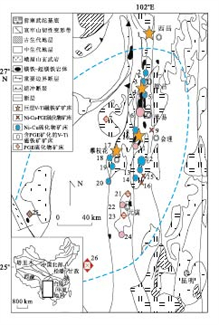
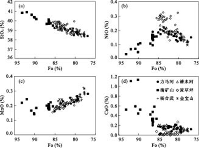
Several mafic-ultramafic intrusions hosting economic Ni-Cu-(PGE) sulfide deposits and sub-economic sulfide mineralization occur in the central zone of the Emeishan large igneous province (LIP). These magmatic sulfide deposits can be divided into the Ni-Cu type (e.g. Limahe and Qingshuihe), Ni-Cu-PGE type (e.g. Qingkuangshan and Huangcaoping) and PGE type (e.g. Jinbaoshan and Yanghewu), according to the variations in the content of platinum-group elements (PGE). Electron microprobe analyses of olivine show that almost all olivine crystals are chrysolite (Fo76.8-Fo89.6), with an exception of some grains from the Qingkuangshan intrusion which are forsterite (Fo90.1-Fo93.1). The compositions of olivine are distinct between intrusions containing different types of sulfides. For the Ni-Cu sulfide-bearing intrusions, the Fo and Ni contents of olivine range from 77 to 87 and from 976×10-6 to 2 176×10-6, respectively. Olivine crystals in the Ni-Cu-PGE sulfide-bearing intrusions have Fo numbers varying from 80 to 86 and (1 024-2 543)×10-6 Ni. The PGE sulfide-bearing intrusions contain olivine crystals with Fo numbers ranging from 78 to 84 and Ni contents of 776×10-6 to 1 755×10-6. The olivine from the Qingkuangshan intrusion, which contains economic Ni-Cu-PGE sulfides, is distinct from others by its high Fo numbers (up to 93.1) and CaO content (0.24%-1.14%) and extremely low Ni (266×10-6). The Ni concentrations and Mg# of parental magma have been estimated by using the compositions of most Fo-rich olivine crystals and the results show a high-MgO picritic-basaltic magma. Modeling of olivine fractional crystallization and sulfide segregation show that the parental magma for the Ni-Cu type mineralized intrusions has experienced the most extensive sulfide segregation (~0.1%). For the Ni-Cu-PGE type intrusions, it is ~0.06%, and for the PGE type intrusions it is ~0.02%. Re-equilibration of the early formed olivine crystals with the trapped liquid can account for the variations of olivine compositions.
Several mafic-ultramafic intrusions hosting economic Ni-Cu-(PGE) sulfide deposits and sub-economic sulfide mineralization occur in the central zone of the Emeishan large igneous province (LIP). These magmatic sulfide deposits can be divided into the Ni-Cu type (e.g. Limahe and Qingshuihe), Ni-Cu-PGE type (e.g. Qingkuangshan and Huangcaoping) and PGE type (e.g. Jinbaoshan and Yanghewu), according to the variations in the content of platinum-group elements (PGE). Electron microprobe analyses of olivine show that almost all olivine crystals are chrysolite (Fo76.8-Fo89.6), with an exception of some grains from the Qingkuangshan intrusion which are forsterite (Fo90.1-Fo93.1). The compositions of olivine are distinct between intrusions containing different types of sulfides. For the Ni-Cu sulfide-bearing intrusions, the Fo and Ni contents of olivine range from 77 to 87 and from 976×10-6 to 2 176×10-6, respectively. Olivine crystals in the Ni-Cu-PGE sulfide-bearing intrusions have Fo numbers varying from 80 to 86 and (1 024-2 543)×10-6 Ni. The PGE sulfide-bearing intrusions contain olivine crystals with Fo numbers ranging from 78 to 84 and Ni contents of 776×10-6 to 1 755×10-6. The olivine from the Qingkuangshan intrusion, which contains economic Ni-Cu-PGE sulfides, is distinct from others by its high Fo numbers (up to 93.1) and CaO content (0.24%-1.14%) and extremely low Ni (266×10-6). The Ni concentrations and Mg# of parental magma have been estimated by using the compositions of most Fo-rich olivine crystals and the results show a high-MgO picritic-basaltic magma. Modeling of olivine fractional crystallization and sulfide segregation show that the parental magma for the Ni-Cu type mineralized intrusions has experienced the most extensive sulfide segregation (~0.1%). For the Ni-Cu-PGE type intrusions, it is ~0.06%, and for the PGE type intrusions it is ~0.02%. Re-equilibration of the early formed olivine crystals with the trapped liquid can account for the variations of olivine compositions.


2010, 35(2): 235-244.
doi: 10.3799/dqkx.2010.023
Abstract:
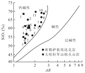
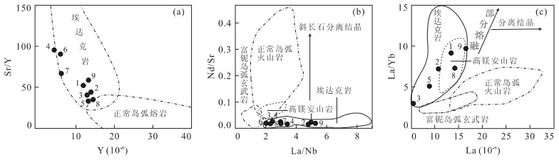
The volcanic rock assemblage of Dahalajunshan Formation is island arc calc-alkaline sodic volcanic rocks formed at plate convergent margins. The distribution of the volcanic rocks coincides with the anomaly of Au-Cu. All the gold-copper ore spots and mineralization spots in this area are volcanic rock-hosted of Dahalajunshan volcanic rocks,which show favorable ore-forming condition of gold-copper deposits. The gold mineralization is hosted in volcanic rocks mostly,and the epithermal gold deposit is the most significant type in this region. The Kulesayi porphyry is calc-alkaline hypabyssal rock,whose average SiO2 is 57.06%-70.74%,and they are rich in Al2O3,Na2O,Sr and LREE,poor in MgO,Y,Yb and very poor in HREE. With their Na2O/K2O of more than 1,Sr/Y of 57.67,and positive anomaly of Eu,they have characters of O-type adakite. The Kulesayi porphyry coincides with anomaly of Mo. Molybedenun deposit with good prospects for further exploration has been found here. The Kulesayi porphyry and Dahalajunshan volcanic rocks compose the assemblage of island arc volcanic rocks in Early Carboniferous,which enriches the tectonic rock association in this region,and is important for the geotectonic evolution study,regional metallogenic law exploration,and prospecting for the gold-copper deposit (relative to island arc volcanic rocks) and copper-molybedenun deposit (relative to adakite).
The volcanic rock assemblage of Dahalajunshan Formation is island arc calc-alkaline sodic volcanic rocks formed at plate convergent margins. The distribution of the volcanic rocks coincides with the anomaly of Au-Cu. All the gold-copper ore spots and mineralization spots in this area are volcanic rock-hosted of Dahalajunshan volcanic rocks,which show favorable ore-forming condition of gold-copper deposits. The gold mineralization is hosted in volcanic rocks mostly,and the epithermal gold deposit is the most significant type in this region. The Kulesayi porphyry is calc-alkaline hypabyssal rock,whose average SiO2 is 57.06%-70.74%,and they are rich in Al2O3,Na2O,Sr and LREE,poor in MgO,Y,Yb and very poor in HREE. With their Na2O/K2O of more than 1,Sr/Y of 57.67,and positive anomaly of Eu,they have characters of O-type adakite. The Kulesayi porphyry coincides with anomaly of Mo. Molybedenun deposit with good prospects for further exploration has been found here. The Kulesayi porphyry and Dahalajunshan volcanic rocks compose the assemblage of island arc volcanic rocks in Early Carboniferous,which enriches the tectonic rock association in this region,and is important for the geotectonic evolution study,regional metallogenic law exploration,and prospecting for the gold-copper deposit (relative to island arc volcanic rocks) and copper-molybedenun deposit (relative to adakite).


2010, 35(2): 245-253.
doi: 10.3799/dqkx.2010.024
Abstract:
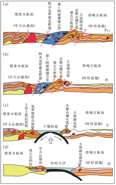
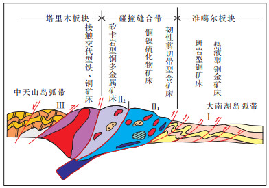
Previous researches indicate that the eastern Tianshan plate suture zone between Kangur and Aqqikkudug faults underwent four stages geological evolution, namely, the formation of Tupan-Hami ocean in Devonian, subduction-type orogeny in Early Carboniferous, collisional orogeny in Late Carboniferous and post orogenic further deformation of the plate suture in Permian. Four obvious tectonic belts of the East Tianshan suture zone can be subdivided from north to south, which constitute a downward convergent wedge-shaped suture zone. Distribution of ore deposits in the East Tianshan is controlled by tectonics. From north to south, they are porphyry copper deposits in the front nappe belt, magmatic Cu (Ni) sulfide deposits and ductile shear zone type gold deposits in the phiolite mélange belt, skarn type copper-ploymetallic deposits and hydrothermal gold deposits in the imbricate rock slices. The above different types in East Tianshan aggregate into four large metallogenic belts: copper metallogenic belt to the north of Kangur fault, gold, copper and nickel metallogenic belt (north belt), iron, copper, and silver polymetallic metallogenic belt of Yamansu-Aqqikkudug area (south belt), iron, lead-zinc and silver metallogenic belt.
Previous researches indicate that the eastern Tianshan plate suture zone between Kangur and Aqqikkudug faults underwent four stages geological evolution, namely, the formation of Tupan-Hami ocean in Devonian, subduction-type orogeny in Early Carboniferous, collisional orogeny in Late Carboniferous and post orogenic further deformation of the plate suture in Permian. Four obvious tectonic belts of the East Tianshan suture zone can be subdivided from north to south, which constitute a downward convergent wedge-shaped suture zone. Distribution of ore deposits in the East Tianshan is controlled by tectonics. From north to south, they are porphyry copper deposits in the front nappe belt, magmatic Cu (Ni) sulfide deposits and ductile shear zone type gold deposits in the phiolite mélange belt, skarn type copper-ploymetallic deposits and hydrothermal gold deposits in the imbricate rock slices. The above different types in East Tianshan aggregate into four large metallogenic belts: copper metallogenic belt to the north of Kangur fault, gold, copper and nickel metallogenic belt (north belt), iron, copper, and silver polymetallic metallogenic belt of Yamansu-Aqqikkudug area (south belt), iron, lead-zinc and silver metallogenic belt.


2010, 35(2): 254-260.
doi: 10.3799/dqkx.2010.025
Abstract:
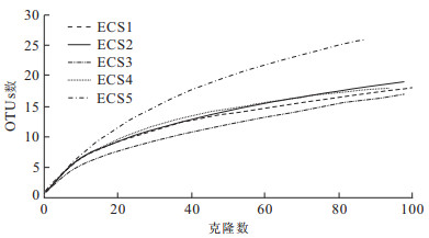
Archaeal 16S rDNA clone libraries were constructed from sediments of different depths to elucidate the distribution and diversity of archaea in the Fujian and Zhejiang coastal mud wedge of the inner continental shelf of the East China Sea. We obtained 473 useable clones and 50 different OTUs (Operational Taxonomic Units). Phylogenetic and statistic analysis of clone libraries show that: archaeal 16S rDNA sequences are within phylums of Crenarchaeota and Euryarchaeota, respectively. The majority of archaeal phylotypes are Miscellaneous Crenarchaeotic Group (MCG), whereas few sequences fall into Marine Benthic Group B (MBG-B), South African Gold Mine Euryarchaeotic Group (SAGMEG), Anaerobic Methanotrophs 3 (ANME-3), Marine Crenarchaeotic Group I (MG-I) and Marine Benthic Group D (MBG-D). There might be anaerobic oxidation of methane carried out by group ANME-3 in the mud wedge. Homologous sequence analyses show that the distribution of archaea in the mud wedge is related to the surrounding environment. UniFrac analysis and sediment environmental parameters indicate that the vertical distribution of archaea closely coincides with the variation of sediment total organic carbon content and grain size.
Archaeal 16S rDNA clone libraries were constructed from sediments of different depths to elucidate the distribution and diversity of archaea in the Fujian and Zhejiang coastal mud wedge of the inner continental shelf of the East China Sea. We obtained 473 useable clones and 50 different OTUs (Operational Taxonomic Units). Phylogenetic and statistic analysis of clone libraries show that: archaeal 16S rDNA sequences are within phylums of Crenarchaeota and Euryarchaeota, respectively. The majority of archaeal phylotypes are Miscellaneous Crenarchaeotic Group (MCG), whereas few sequences fall into Marine Benthic Group B (MBG-B), South African Gold Mine Euryarchaeotic Group (SAGMEG), Anaerobic Methanotrophs 3 (ANME-3), Marine Crenarchaeotic Group I (MG-I) and Marine Benthic Group D (MBG-D). There might be anaerobic oxidation of methane carried out by group ANME-3 in the mud wedge. Homologous sequence analyses show that the distribution of archaea in the mud wedge is related to the surrounding environment. UniFrac analysis and sediment environmental parameters indicate that the vertical distribution of archaea closely coincides with the variation of sediment total organic carbon content and grain size.


2010, 35(2): 261-267.
doi: 10.3799/dqkx.2010.026
Abstract:
The trace metal elements and average grain size were determined for sediments of Pearl River Estuary and three important factors were identified using factor analysis method, which controls chemical compositions of sediments, such as catchment erosion, biogenic deposit, marine dominated condition. Moreover, further research indicates that the factor score curves of the three factors can be used to represent the changes of humidity, temperature and the hydrodynamics, respectively, which provides a good effective approach to paleoenviromental reconstruction. On the basis of the study, the evolution history of the regional climate and environment is evaluated and it is revealed that the basic climate succession in the region of Pearl River Delta is the cool-humid, cool-dry, warm-dry, warm-dry, warm-humid and warm-dry successively.
The trace metal elements and average grain size were determined for sediments of Pearl River Estuary and three important factors were identified using factor analysis method, which controls chemical compositions of sediments, such as catchment erosion, biogenic deposit, marine dominated condition. Moreover, further research indicates that the factor score curves of the three factors can be used to represent the changes of humidity, temperature and the hydrodynamics, respectively, which provides a good effective approach to paleoenviromental reconstruction. On the basis of the study, the evolution history of the regional climate and environment is evaluated and it is revealed that the basic climate succession in the region of Pearl River Delta is the cool-humid, cool-dry, warm-dry, warm-dry, warm-humid and warm-dry successively.


2010, 35(2): 268-276.
doi: 10.3799/dqkx.2010.027
Abstract:
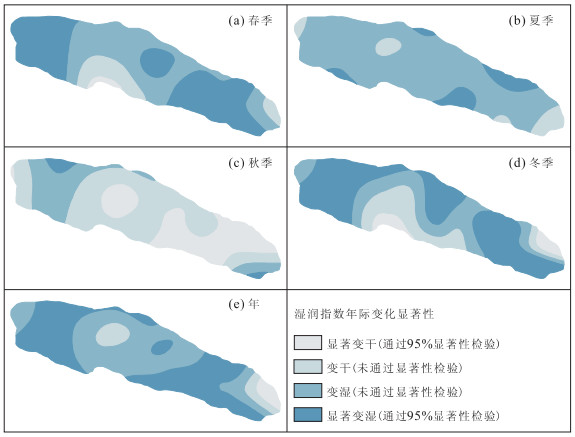
Based on the climatic data of 20 weather stations from 1960 to 2006, the monthly potential evaporation was calculated using the Penman-Monteith model, and then the monthly humid index was reconstructed in Qilian Mountains and Hexi Corridor. In order to study the temporal and spatial characteristics of the dry-wet conditions in the study area, the seasonal and annual humid indices were analyzed. Statistical results indicate that the study area was drier before 1980s, and the humid index has been on the rise since 1960s. The change rate of annual humid index was 0.001 4 a-1, which indicates that the humid condition of study area has become better obviously, especially in spring and winter. The spatial change of dry-wet conditions of the study area shows that it is becoming wetter from eastern to western parts in east region with an exception of the eastern area of Wushaoling Mountains which is becoming drier; for most middle region, it is also becoming drier insignificantly except for the northern area of Shule South Mountains and Zhangye oasis, and, it is becoming wetter in most western region except for the western area of Dunhuang City where it is becoming wetter insignificantly.
Based on the climatic data of 20 weather stations from 1960 to 2006, the monthly potential evaporation was calculated using the Penman-Monteith model, and then the monthly humid index was reconstructed in Qilian Mountains and Hexi Corridor. In order to study the temporal and spatial characteristics of the dry-wet conditions in the study area, the seasonal and annual humid indices were analyzed. Statistical results indicate that the study area was drier before 1980s, and the humid index has been on the rise since 1960s. The change rate of annual humid index was 0.001 4 a-1, which indicates that the humid condition of study area has become better obviously, especially in spring and winter. The spatial change of dry-wet conditions of the study area shows that it is becoming wetter from eastern to western parts in east region with an exception of the eastern area of Wushaoling Mountains which is becoming drier; for most middle region, it is also becoming drier insignificantly except for the northern area of Shule South Mountains and Zhangye oasis, and, it is becoming wetter in most western region except for the western area of Dunhuang City where it is becoming wetter insignificantly.


2010, 35(2): 277-282.
doi: 10.3799/dqkx.2010.028
Abstract:
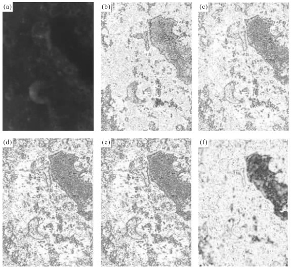
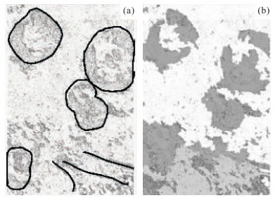
The classical edge extracting algorithms in the image processing can extract lunar surface geological features, but can not extract texture features of lunar terrain from Chang'e-1 image data. This paper suggests a method of coherent algorithm to extract the lunar surface geological features with Chang'e-1 data, which is based on coherent calculation of signals in digital signal processing transplanted into image processing for lunar data. We processed some Chang'e-1 image data by using coherent calculation which involves calculating the similarity between pixels or pixel groups. By comparing several classical algorithms with our algorithm, the effectiveness of this method is demonstrated. The coherent algorithm can extract linear and circular geological structure features as well as the texture features of lunar terrain from Chang'e-1 lunar image at the same time. And it is also able to identify the small-diameter craters. So the method can be applied to computer-driven automatic recognition of lunar structures and landforms for evolution analysis of the moon.
The classical edge extracting algorithms in the image processing can extract lunar surface geological features, but can not extract texture features of lunar terrain from Chang'e-1 image data. This paper suggests a method of coherent algorithm to extract the lunar surface geological features with Chang'e-1 data, which is based on coherent calculation of signals in digital signal processing transplanted into image processing for lunar data. We processed some Chang'e-1 image data by using coherent calculation which involves calculating the similarity between pixels or pixel groups. By comparing several classical algorithms with our algorithm, the effectiveness of this method is demonstrated. The coherent algorithm can extract linear and circular geological structure features as well as the texture features of lunar terrain from Chang'e-1 lunar image at the same time. And it is also able to identify the small-diameter craters. So the method can be applied to computer-driven automatic recognition of lunar structures and landforms for evolution analysis of the moon.


2010, 35(2): 283-290.
doi: 10.3799/dqkx.2010.029
Abstract:
In order to efficiently extract quantitative parameters in active tectonics research, JX4C digital photogrammetric system has been used to found stereo model based on CORONA KH-4B stereo pairs with 2 m resolution, which were declassified in 1995 by USA for scientific purpose. Meanwhile, large scale digital elevation model (DEM) and digital orthophoto mapping (DOM) have been formed. These processing techniques are applied in a case study of the Kuqa fold-and-thrust belt in southern Tianshan, China, to quantitatively analyze the Kumugeliemu active fault and the Qiulitage active fault-related folds, considering the seismic reflection profiles therein and data from field measurements. Results show that the CORONA stereo pairs can be used in JX4C digital photogrammetric system, and root mean square error (RMS) of relative orientation is about 0.01 mm, while absolute orientation is about 10 m. Some parameters for deformation of river terrace and fault and fold scarps are identified and measured, which are helpful to reveal the characters of active tectonics. The processing techniques are feasible and effective particularly in remote settings with complex topology and the measurement precision can meet the requirement for analysis of active tectonics.
In order to efficiently extract quantitative parameters in active tectonics research, JX4C digital photogrammetric system has been used to found stereo model based on CORONA KH-4B stereo pairs with 2 m resolution, which were declassified in 1995 by USA for scientific purpose. Meanwhile, large scale digital elevation model (DEM) and digital orthophoto mapping (DOM) have been formed. These processing techniques are applied in a case study of the Kuqa fold-and-thrust belt in southern Tianshan, China, to quantitatively analyze the Kumugeliemu active fault and the Qiulitage active fault-related folds, considering the seismic reflection profiles therein and data from field measurements. Results show that the CORONA stereo pairs can be used in JX4C digital photogrammetric system, and root mean square error (RMS) of relative orientation is about 0.01 mm, while absolute orientation is about 10 m. Some parameters for deformation of river terrace and fault and fold scarps are identified and measured, which are helpful to reveal the characters of active tectonics. The processing techniques are feasible and effective particularly in remote settings with complex topology and the measurement precision can meet the requirement for analysis of active tectonics.


2010, 35(2): 291-301.
doi: 10.3799/dqkx.2010.030
Abstract:
Mars gullies, the very young features exposed on crater rims and sand dunes, are studied in detail using 15 HiRISE images and 107 MOC images in this research, and the hypotheses of gully origination are examined. The results support the hypothesis that the gullies were formed by the erosion of liquid water that carried sand particles. And the existence of polygonal shape on crater walls suggests that water ice maybe located on Mars subsurface, which can melt to liquid water and produce gullies.
Mars gullies, the very young features exposed on crater rims and sand dunes, are studied in detail using 15 HiRISE images and 107 MOC images in this research, and the hypotheses of gully origination are examined. The results support the hypothesis that the gullies were formed by the erosion of liquid water that carried sand particles. And the existence of polygonal shape on crater walls suggests that water ice maybe located on Mars subsurface, which can melt to liquid water and produce gullies.


2010, 35(2): 302-310.
doi: 10.3799/dqkx.2010.031
Abstract:
The digital mine software development is the key step for building the digital mine. A digital mine software named QuantyMine has been developed, which is composed of seven subsystems and can be employed to build the digital mine. There are many key technologies involved in the software, three of which are discussed in this paper. The first one is three-dimensional visualization mine modeling technology; the second one is dynamic reserve estimation technology responding to the changing market; and the third one is system integration technology for mine informationization. The following functions can be realized by employing the QuantyMine: (1) All kinds of mine data including survey data, geology data, geophysical data, geochemical data, assay data, environment data, remote sensing data can be stored in the central Oracle database, which acts as a shared data platform for the digital mine. (2) All kinds of mine map could be drawn automatically or semi-automatically by computer based on the central mine subject database. (3) 3D mine modeling and visualization, and three-dimension spatial analyses can be fulfiled. (4)It facilitates the mine reserve estimation using vertical section method, geological block method and kriging method estimate. (5) Mine design and planning can be performed. (6) Digital mine can be run on the internet. Based on this system, a basic digital mine of Zijin copper and gold mine has been constructed.
The digital mine software development is the key step for building the digital mine. A digital mine software named QuantyMine has been developed, which is composed of seven subsystems and can be employed to build the digital mine. There are many key technologies involved in the software, three of which are discussed in this paper. The first one is three-dimensional visualization mine modeling technology; the second one is dynamic reserve estimation technology responding to the changing market; and the third one is system integration technology for mine informationization. The following functions can be realized by employing the QuantyMine: (1) All kinds of mine data including survey data, geology data, geophysical data, geochemical data, assay data, environment data, remote sensing data can be stored in the central Oracle database, which acts as a shared data platform for the digital mine. (2) All kinds of mine map could be drawn automatically or semi-automatically by computer based on the central mine subject database. (3) 3D mine modeling and visualization, and three-dimension spatial analyses can be fulfiled. (4)It facilitates the mine reserve estimation using vertical section method, geological block method and kriging method estimate. (5) Mine design and planning can be performed. (6) Digital mine can be run on the internet. Based on this system, a basic digital mine of Zijin copper and gold mine has been constructed.


2010, 35(2): 311-316.
doi: 10.3799/dqkx.2010.032
Abstract:
Because of poor understanding about the mechanism of rockbust and about the effect factors, the statistic data of large amounts of rockburst are typical imbalanced data sets (IDS). On the basis of analyzing re-sampling technology, a novel hybrid re-sampling technique based on Automated Adaptive Selection of the Number of Nearest Neighbors (ADSNN-Hybrid RS) is proposed and applied to study the prediction of rockburst. This method takes advantage of both technology of improved Synthetic Minority Over-sampling Technique (SMOTE) method and Neighborhood Cleaning Rule (NCR) data cleaning method. In the procedure of over-sampling with the SMOTE method, blindfold new synthetic minority class examples by randomly interpolating pairs of closest neighbors were added into the minority class; and data sets with nominal features can not be dealt with. These two problems were solved by the automated adaptive selection of nearest neighbors and adjusting the neighbor selective strategy. As a consequence, the quality of the new samples can be well controlled. In the procedure of under-sampling, by using the improved under-sampling technique of neighborhood cleaning rule, borderline majority class examples and the noisy or redundant data were removed. The main motivation behind these methods is not only to balance the training data, but also to remove noisy examples lying on the wrong side of the decision border. The removal of noisy examples might aid in finding better-defined class clusters, therefore, allow the creation of simpler models with better generalization capabilities. In turn, it promises effective processing of IDS and a considerably enhanced classifier performance. The VCR rockburst data sets were employed as a sample IDS for classification and prediction. By adding extra artificial minority class samples as the expanded training set, experiment was conducted, which yields exactly consistent prediction results with the actual situation. The ADSNN-Hybrid RS and classification scheme we developed is feasible and reasonable for applications of IDS from engineering. Thus this method can be readily implemented to determine the controlling factors of engineering. Such a prediction can provide reasonable and sufficient guidance to design a safe construction scheme in deep mining engineering.
Because of poor understanding about the mechanism of rockbust and about the effect factors, the statistic data of large amounts of rockburst are typical imbalanced data sets (IDS). On the basis of analyzing re-sampling technology, a novel hybrid re-sampling technique based on Automated Adaptive Selection of the Number of Nearest Neighbors (ADSNN-Hybrid RS) is proposed and applied to study the prediction of rockburst. This method takes advantage of both technology of improved Synthetic Minority Over-sampling Technique (SMOTE) method and Neighborhood Cleaning Rule (NCR) data cleaning method. In the procedure of over-sampling with the SMOTE method, blindfold new synthetic minority class examples by randomly interpolating pairs of closest neighbors were added into the minority class; and data sets with nominal features can not be dealt with. These two problems were solved by the automated adaptive selection of nearest neighbors and adjusting the neighbor selective strategy. As a consequence, the quality of the new samples can be well controlled. In the procedure of under-sampling, by using the improved under-sampling technique of neighborhood cleaning rule, borderline majority class examples and the noisy or redundant data were removed. The main motivation behind these methods is not only to balance the training data, but also to remove noisy examples lying on the wrong side of the decision border. The removal of noisy examples might aid in finding better-defined class clusters, therefore, allow the creation of simpler models with better generalization capabilities. In turn, it promises effective processing of IDS and a considerably enhanced classifier performance. The VCR rockburst data sets were employed as a sample IDS for classification and prediction. By adding extra artificial minority class samples as the expanded training set, experiment was conducted, which yields exactly consistent prediction results with the actual situation. The ADSNN-Hybrid RS and classification scheme we developed is feasible and reasonable for applications of IDS from engineering. Thus this method can be readily implemented to determine the controlling factors of engineering. Such a prediction can provide reasonable and sufficient guidance to design a safe construction scheme in deep mining engineering.


2010, 35(2): 317-323.
doi: 10.3799/dqkx.2010.033
Abstract:
A catastrophic earthquake always intensively disturbs ground strata and affects the slope stability for a long period of time. The Wenchuan earthquake not only triggered serious coseismic landslides, but also extensively accelerated the landslide activity during the subsequent heavy rains. Based on the interpretation of high resolution of aerial photographs, 1 214 landslides are identified, most of which are shallow landslides, rock falls, and rock slides triggered in the high seismic intensity region of the Wenchuan earthquake near the Beichuan City and along the valleys of the Jianjiang River. A heavy rainfall on 24 September, 2008 triggered more landslides and debris flows in the central part of the area affected by the Wenchuan earthquake. The accumulated precipitation triggering landslides and debris flows is 272.7 mm in two days, while the rainfall amount and intensity recorded in this area have a return period of about 20 years. 878 new landslides in the study area of 340 km2 are identified by interpretation of SPOT images. To understand the impact of the Wenchuan earthquake on the landslide occurrence due to subsequent heavy rainfall, this study mainly focuses on the variations in the the density of coseismic landslides and following rainfall-induced landslides through aerial photographs and SPOT images. Comparison of aerial photographs taken on 18 May, 2008 (after the "5·12" Wenchuan earthquake) and SPOT images taken on 14 October, 2008 (after "9·24" rainstorm event) indicates that the landslide number in the study area increases by 42%, while landslide area increases by 46.6%, which shows the great impact of the heavy rainfall after the earthquake on the development and activity of landslides in the study area. The above study results also show that the Wenchuan earthquake affected area is particularly susceptible to landslides and debris flow occurrence after extreme rainfall events.
A catastrophic earthquake always intensively disturbs ground strata and affects the slope stability for a long period of time. The Wenchuan earthquake not only triggered serious coseismic landslides, but also extensively accelerated the landslide activity during the subsequent heavy rains. Based on the interpretation of high resolution of aerial photographs, 1 214 landslides are identified, most of which are shallow landslides, rock falls, and rock slides triggered in the high seismic intensity region of the Wenchuan earthquake near the Beichuan City and along the valleys of the Jianjiang River. A heavy rainfall on 24 September, 2008 triggered more landslides and debris flows in the central part of the area affected by the Wenchuan earthquake. The accumulated precipitation triggering landslides and debris flows is 272.7 mm in two days, while the rainfall amount and intensity recorded in this area have a return period of about 20 years. 878 new landslides in the study area of 340 km2 are identified by interpretation of SPOT images. To understand the impact of the Wenchuan earthquake on the landslide occurrence due to subsequent heavy rainfall, this study mainly focuses on the variations in the the density of coseismic landslides and following rainfall-induced landslides through aerial photographs and SPOT images. Comparison of aerial photographs taken on 18 May, 2008 (after the "5·12" Wenchuan earthquake) and SPOT images taken on 14 October, 2008 (after "9·24" rainstorm event) indicates that the landslide number in the study area increases by 42%, while landslide area increases by 46.6%, which shows the great impact of the heavy rainfall after the earthquake on the development and activity of landslides in the study area. The above study results also show that the Wenchuan earthquake affected area is particularly susceptible to landslides and debris flow occurrence after extreme rainfall events.


2010, 35(2): 324-330.
doi: 10.3799/dqkx.2010.034
Abstract:
5·12 Wenchuan earthquake triggered a series of secondary landslides, landslides, debris flows, and other geological disasters, which posed a major threat to peoples' lives and property and socio-economic development. For risk assessment of secondary geological hazards in the area, the worst-hit Wenchuan County was selected as the study area. Remote sensing and geographic information technology spatial data management and spatial data analysis platform have been applied to gain relevant information, to make a correlative analysis between secondary geological disasters in the study area and the topography, lithology, hydrology, earthquake rupture. In addition, information value method has been used to evaluate the risk of secondary geological disasters. It is found that the area of high risk, moderate risk and low risk is 1 130.196 km2, 1 739.584 km2, 1 213.219 km2 respectively. The distribution of secondary geology disaster triggered by earthquake has the colony type distribution characteristic featured with a concentrated development of geological disasters in the fault zone and the nearby regions and a quick decay and the fragmentary distribution farther away form the fault zone areas. Analysis also shows that risk of secondary geological disaster in north and east areas of Wenchuan is heavy, while that in the west and south areas is light, which is coincident with the reality. The study further demonstrates that the geographical information system combined with information value model can quickly and effectively evaluate the spatial distribution and risk of secondary geological disasters.
5·12 Wenchuan earthquake triggered a series of secondary landslides, landslides, debris flows, and other geological disasters, which posed a major threat to peoples' lives and property and socio-economic development. For risk assessment of secondary geological hazards in the area, the worst-hit Wenchuan County was selected as the study area. Remote sensing and geographic information technology spatial data management and spatial data analysis platform have been applied to gain relevant information, to make a correlative analysis between secondary geological disasters in the study area and the topography, lithology, hydrology, earthquake rupture. In addition, information value method has been used to evaluate the risk of secondary geological disasters. It is found that the area of high risk, moderate risk and low risk is 1 130.196 km2, 1 739.584 km2, 1 213.219 km2 respectively. The distribution of secondary geology disaster triggered by earthquake has the colony type distribution characteristic featured with a concentrated development of geological disasters in the fault zone and the nearby regions and a quick decay and the fragmentary distribution farther away form the fault zone areas. Analysis also shows that risk of secondary geological disaster in north and east areas of Wenchuan is heavy, while that in the west and south areas is light, which is coincident with the reality. The study further demonstrates that the geographical information system combined with information value model can quickly and effectively evaluate the spatial distribution and risk of secondary geological disasters.


