2010 Vol. 35, No. 3
Display Method:
2010, 35(3): 331-337.
doi: 10.3799/dqkx.2010.035
 PDF 721KB
Abstract:
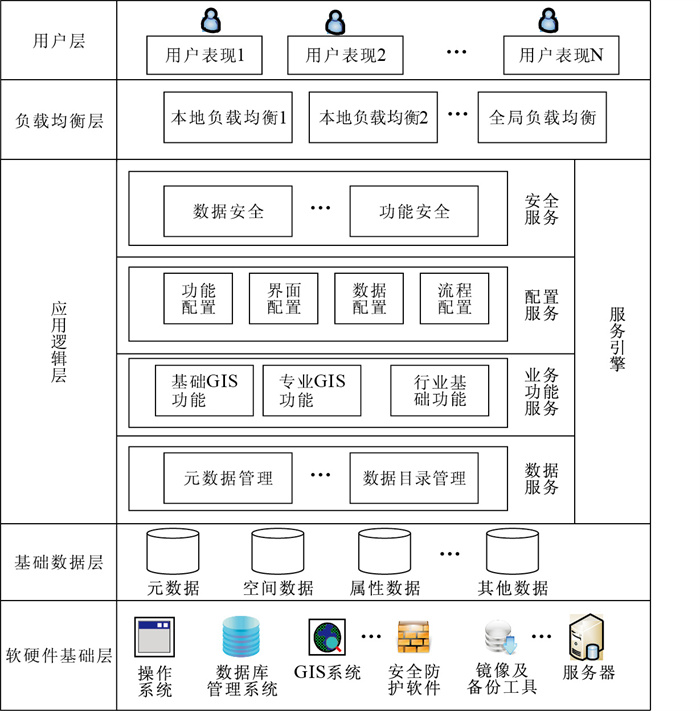
To fully integrate various urban information resources and effectively consolidate business applications of all urban departments, the foundation information supporting platform is established to meet the need of building information foundation platform for digital city, which can manage various urban information resources effectively and provide various applications and services. The integration development platform for digital is realized by the MapGIS data center technology of data warehouse, function warehouse, building up secondary development. And the platform can provide a unified application and service system for all kinds of urban business and realize network-based social services and sharing various urban information resources. Then it can maximize the economic and social benefits of urban information resources in China.
To fully integrate various urban information resources and effectively consolidate business applications of all urban departments, the foundation information supporting platform is established to meet the need of building information foundation platform for digital city, which can manage various urban information resources effectively and provide various applications and services. The integration development platform for digital is realized by the MapGIS data center technology of data warehouse, function warehouse, building up secondary development. And the platform can provide a unified application and service system for all kinds of urban business and realize network-based social services and sharing various urban information resources. Then it can maximize the economic and social benefits of urban information resources in China.


2010, 35(3): 338-344.
doi: 10.3799/dqkx.2010.036
Abstract:
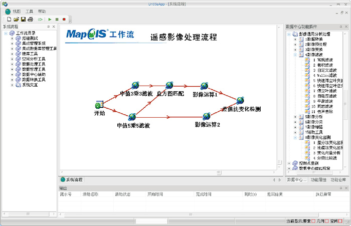
In order to break through business-oriented systems, and issue-oriented modeling technology to improve the geographic information system (GIS) application systems to adapt to ever-changing needs and the ability to reuse, workflow technology combined with application of formal language is used to achieve precise quantitative mathematical model of the effective conversion and heavy methods on the abstract operator space and expansion is used to simplify the large-scale analysis of heterogeneous modeling and applications to and the complex logic modeling. As a result, the new spatial analysis modeling is featured by visualization, precision, simplicity. On this basis, combined with visual interface building, functional warehouse and space resource management, support cross-platform GIS applications is built quickly, which in turn builds integrated environment for multi-domain application systems integration and functionality, provides the means to reuse, reduces GIS application difficulty of system development for GIS applications, provides in-depth and comprehensive technical support for GIS application.
In order to break through business-oriented systems, and issue-oriented modeling technology to improve the geographic information system (GIS) application systems to adapt to ever-changing needs and the ability to reuse, workflow technology combined with application of formal language is used to achieve precise quantitative mathematical model of the effective conversion and heavy methods on the abstract operator space and expansion is used to simplify the large-scale analysis of heterogeneous modeling and applications to and the complex logic modeling. As a result, the new spatial analysis modeling is featured by visualization, precision, simplicity. On this basis, combined with visual interface building, functional warehouse and space resource management, support cross-platform GIS applications is built quickly, which in turn builds integrated environment for multi-domain application systems integration and functionality, provides the means to reuse, reduces GIS application difficulty of system development for GIS applications, provides in-depth and comprehensive technical support for GIS application.


2010, 35(3): 345-350.
doi: 10.3799/dqkx.2010.037
Abstract:
As spatial data center technology is increasingly well-developed and highly sophisticated, the land resource management area is in bad need of a new model of distributed geographic information system (GIS) applications, which is featured by the integrated management and utilization of spatial data. In addition, much has to be worked out soon in the areas such spatial data integration and comprehensive use, incremental updates, as well as software functions sharing and cooperative development of different manufacturers. In this paper, based on the spatial data center technology, and by introducing the distributed heterogeneous spatial data seamless integration technology, a concept model called seamless spatial data center is established, and the technology is discussed.
As spatial data center technology is increasingly well-developed and highly sophisticated, the land resource management area is in bad need of a new model of distributed geographic information system (GIS) applications, which is featured by the integrated management and utilization of spatial data. In addition, much has to be worked out soon in the areas such spatial data integration and comprehensive use, incremental updates, as well as software functions sharing and cooperative development of different manufacturers. In this paper, based on the spatial data center technology, and by introducing the distributed heterogeneous spatial data seamless integration technology, a concept model called seamless spatial data center is established, and the technology is discussed.


2010, 35(3): 351-356.
doi: 10.3799/dqkx.2010.038
Abstract:
To solve the problem about function configuration, scalability and multi-tenancy efficiency based on the geographic information system (GIS) fourth level model of "Software as a Service" architecture, the model architecture for GIS service engine of configurable function is presented. And the kernel technologies including work flow, function warehouse, configuration, right management for GIS service engine of function configuration are introduced. Then remote image application system is constructed based on the technology of GIS service engine of function configuration, and it provides technical support for the new application model of software as a service.
To solve the problem about function configuration, scalability and multi-tenancy efficiency based on the geographic information system (GIS) fourth level model of "Software as a Service" architecture, the model architecture for GIS service engine of configurable function is presented. And the kernel technologies including work flow, function warehouse, configuration, right management for GIS service engine of function configuration are introduced. Then remote image application system is constructed based on the technology of GIS service engine of function configuration, and it provides technical support for the new application model of software as a service.


2010, 35(3): 357-361.
doi: 10.3799/dqkx.2010.039
Abstract:
More and more organizations and departments need collaboration of geographic information function to complete work. The key is component reuse and collaboration in geographic information system (GIS) area. This paper adopts the component framework based on black box reuse, discusses the key technologies of function warehouse. Firstly, multi-granularity component structure is presented, including atom granularity, function component, function plug-in and function flow; Secondly, uniform function protocol is defined for unified management and release, unified configuration and system building on heterogeneous function resources. Through unified protocol, running service can discover and call function resource dynamically and achieve the function resource position and parameter transfer. Function warehouse can integrate various types of function resources, implement the uniform management and call in data center, and finally achieve collaboration of geographic information function with workflow engine and visual model building tools.
More and more organizations and departments need collaboration of geographic information function to complete work. The key is component reuse and collaboration in geographic information system (GIS) area. This paper adopts the component framework based on black box reuse, discusses the key technologies of function warehouse. Firstly, multi-granularity component structure is presented, including atom granularity, function component, function plug-in and function flow; Secondly, uniform function protocol is defined for unified management and release, unified configuration and system building on heterogeneous function resources. Through unified protocol, running service can discover and call function resource dynamically and achieve the function resource position and parameter transfer. Function warehouse can integrate various types of function resources, implement the uniform management and call in data center, and finally achieve collaboration of geographic information function with workflow engine and visual model building tools.


2010, 35(3): 362-368.
doi: 10.3799/dqkx.2010.040
Abstract:
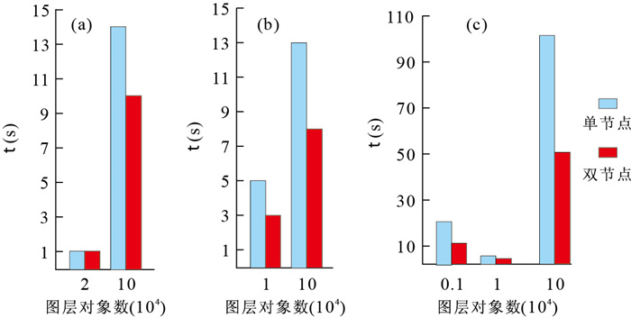
In order to improve spatial operation efficiency of massive data in distributed environment and to solve the interactive design problems of spatial analysis processing module designed to service agreement with the underlying database, spatial data models and so on. The basic characteristics of distributed computing are analyzed in this paper. The authors of this paper discuss the distributed computing spatial information technology system form the following aspects: apace computing task decomposition, distributed spatial data classification method, sharing data replication strategy, the data partitioning strategy based on the load and the caching mechanism of space computing framework. Based on this framework, the authors have developed the system for solving the practical problems, and solved the efficiency of large-scale spatial data operations in the complex distributed environment. At last, the distributed computing environment test of the classic space experiments has shown that, the framework is a design novelty, and can greatly reduce the spatial computing time in the distributed environments.
In order to improve spatial operation efficiency of massive data in distributed environment and to solve the interactive design problems of spatial analysis processing module designed to service agreement with the underlying database, spatial data models and so on. The basic characteristics of distributed computing are analyzed in this paper. The authors of this paper discuss the distributed computing spatial information technology system form the following aspects: apace computing task decomposition, distributed spatial data classification method, sharing data replication strategy, the data partitioning strategy based on the load and the caching mechanism of space computing framework. Based on this framework, the authors have developed the system for solving the practical problems, and solved the efficiency of large-scale spatial data operations in the complex distributed environment. At last, the distributed computing environment test of the classic space experiments has shown that, the framework is a design novelty, and can greatly reduce the spatial computing time in the distributed environments.


2010, 35(3): 369-374.
doi: 10.3799/dqkx.2010.041
Abstract:
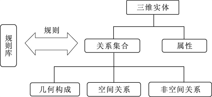
Three-dimensional objects are in various forms, and opinions differ as to the spatial relationships between objects. It is even more difficult to reach a consensus on the relationship between space and non-spatial three-dimensional data model. There are three kinds of three-dimensional space-oriented, namely, entity type, relationship-oriented and mixed-type, but the traditional models have drawbacks, such as topology difficulties for operation, incomplete object semantics description, lack of relationship expression. Based on a rule-based library, we design a new three-dimensional data model aimed at retaining the advantages and overcoming the disadvantages of the traditional models. The new model takes into account the topology of three-dimensional vector-oriented data model entities, introducing the concept of rules, unifying the relational and object data model. building a rule base for space objects and structures with a unified, complete expression and management. The three-dimensional spatial data model has been applied in a number of cities both in geology and mining and it proves to be successful. The success of applications shows that the model is featured by unities of expression, with a custom, scalable spatial object-relational skills between the space object and the object of its structure, adapting to the complex application requirements, and it has good application prospects.
Three-dimensional objects are in various forms, and opinions differ as to the spatial relationships between objects. It is even more difficult to reach a consensus on the relationship between space and non-spatial three-dimensional data model. There are three kinds of three-dimensional space-oriented, namely, entity type, relationship-oriented and mixed-type, but the traditional models have drawbacks, such as topology difficulties for operation, incomplete object semantics description, lack of relationship expression. Based on a rule-based library, we design a new three-dimensional data model aimed at retaining the advantages and overcoming the disadvantages of the traditional models. The new model takes into account the topology of three-dimensional vector-oriented data model entities, introducing the concept of rules, unifying the relational and object data model. building a rule base for space objects and structures with a unified, complete expression and management. The three-dimensional spatial data model has been applied in a number of cities both in geology and mining and it proves to be successful. The success of applications shows that the model is featured by unities of expression, with a custom, scalable spatial object-relational skills between the space object and the object of its structure, adapting to the complex application requirements, and it has good application prospects.


2010, 35(3): 375-379.
doi: 10.3799/dqkx.2010.042
Abstract:
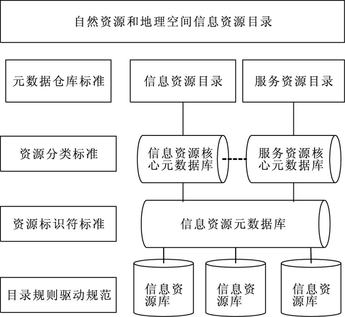
E-government information resources integration based on catalog system are beneficial to the sharing and exchange of information resources. According to the characteristics of the natural resources and geo-spatial information resources, the paper analyzed the catalog system of e-government resources, and then put forward the data catalog system of the natural resources and geo-spatial information resources integration transformation to deal with synthesis decision-making. This integrated approach establishes the basis of the organic integration of information resources, and adapts to the dynamic changes of information resources. At the same time, through cataloging, it can make data providers and share sectors clear, and provides the establishment of long-term mechanism for the integration and sharing of information resources.
E-government information resources integration based on catalog system are beneficial to the sharing and exchange of information resources. According to the characteristics of the natural resources and geo-spatial information resources, the paper analyzed the catalog system of e-government resources, and then put forward the data catalog system of the natural resources and geo-spatial information resources integration transformation to deal with synthesis decision-making. This integrated approach establishes the basis of the organic integration of information resources, and adapts to the dynamic changes of information resources. At the same time, through cataloging, it can make data providers and share sectors clear, and provides the establishment of long-term mechanism for the integration and sharing of information resources.


2010, 35(3): 380-384.
doi: 10.3799/dqkx.2010.043
Abstract:
In order to solve the data organization problem and improve the query efficiency of seamless integration of spatial data and its incremental update in distributed and heterogeneous environment, some features of geo-database mechanism can be used, such as storage in multi-components and incremental storage. Through corresponding seam data to the deleted component in version mechanism, and corresponding seamless data to the added component in version mechanism, and corresponding seamless consistency maintenance process to the data version update process, it establishes a new mechanism called spatial data seamless integration version management mechanism. By this method, seamless integration issue is transformed into initial seamless version establishment issue and version data seamless consistency maintenance issue, and seamless spatial query and dynamic splicing process is transformed into the distributed version query process, which reduces the computational complexity and enhances system efficiency; with the seamless version mechanism, natural storage support for the incremental update is also provided.
In order to solve the data organization problem and improve the query efficiency of seamless integration of spatial data and its incremental update in distributed and heterogeneous environment, some features of geo-database mechanism can be used, such as storage in multi-components and incremental storage. Through corresponding seam data to the deleted component in version mechanism, and corresponding seamless data to the added component in version mechanism, and corresponding seamless consistency maintenance process to the data version update process, it establishes a new mechanism called spatial data seamless integration version management mechanism. By this method, seamless integration issue is transformed into initial seamless version establishment issue and version data seamless consistency maintenance issue, and seamless spatial query and dynamic splicing process is transformed into the distributed version query process, which reduces the computational complexity and enhances system efficiency; with the seamless version mechanism, natural storage support for the incremental update is also provided.


2010, 35(3): 385-390.
doi: 10.3799/dqkx.2010.044
Abstract:
Spatial objects' matching is the first step and also the key step of incremental updating for spatial database. In this paper, a spatial objects' matching algorithm for finding the changed information is studied. On the basis of the research on the uncertainty problem existing in spatial data, this paper suggests fuzzy theory is introduced to spatial objects' matching algorithm. The paper focuses on how to solve spatial objects' matching problem by using fuzzy methods. And taking the region entities as examples for studying matching process, the author proposes the region objects' matching algorithm considering associated area similarities. This algorithm firstly uses associated area similarity's measuring genes to confirm the fuzzy topological relationship matrix, then quantifies the degree of membership matrix, and finally determines the relationship between fuzzy topological classifications. By using frame index, associated area similarity's measuring genes, the algorithm optimizes and simplifies computational complexity, and improves the algorithm efficiency as well.
Spatial objects' matching is the first step and also the key step of incremental updating for spatial database. In this paper, a spatial objects' matching algorithm for finding the changed information is studied. On the basis of the research on the uncertainty problem existing in spatial data, this paper suggests fuzzy theory is introduced to spatial objects' matching algorithm. The paper focuses on how to solve spatial objects' matching problem by using fuzzy methods. And taking the region entities as examples for studying matching process, the author proposes the region objects' matching algorithm considering associated area similarities. This algorithm firstly uses associated area similarity's measuring genes to confirm the fuzzy topological relationship matrix, then quantifies the degree of membership matrix, and finally determines the relationship between fuzzy topological classifications. By using frame index, associated area similarity's measuring genes, the algorithm optimizes and simplifies computational complexity, and improves the algorithm efficiency as well.


2010, 35(3): 391-396.
doi: 10.3799/dqkx.2010.045
Abstract:
In order to manage huge data of basic national geographic information, analyze data contents and composites of national basic geographic information, we build a mapset model based on entity-oriented spatial data model of MapGIS, adopting the ideas of MapGIS data center, and making an analogy of the mainstream data model of database. A study is carried out on the model, including probing into its characters, introducing its basic operators, such as building spatial database, integrated management and performance of spatial database, security control and maintenance of spatial database based on mapset model, and applying the mapset model in building national basic geographic information database system. The result shows the model has potential impact on all geographic information system (GIS) applications.
In order to manage huge data of basic national geographic information, analyze data contents and composites of national basic geographic information, we build a mapset model based on entity-oriented spatial data model of MapGIS, adopting the ideas of MapGIS data center, and making an analogy of the mainstream data model of database. A study is carried out on the model, including probing into its characters, introducing its basic operators, such as building spatial database, integrated management and performance of spatial database, security control and maintenance of spatial database based on mapset model, and applying the mapset model in building national basic geographic information database system. The result shows the model has potential impact on all geographic information system (GIS) applications.


2010, 35(3): 397-402.
doi: 10.3799/dqkx.2010.046
Abstract:
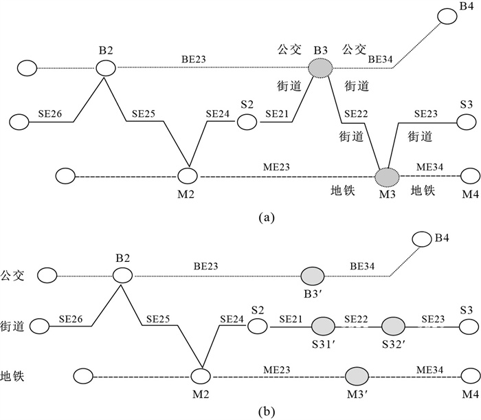
City transportation has transformed from single modal to multimodal composite transportation system. Compared with single modal network model, multimodal composite transport network model adds the concept of mode transfer; therefore its topological consistency maintenance is more complex. Aimed at the difference and complexity between single mode and multimode, this paper analyzes the changing types in multimodal network, presents the topological consistency maintenance methods for these typical changing types. Test shows that these methods can correctly maintain the topological relationship of multimodal network. The method presented in the paper provides valuable references for study on topological consistency of multimodal network.
City transportation has transformed from single modal to multimodal composite transportation system. Compared with single modal network model, multimodal composite transport network model adds the concept of mode transfer; therefore its topological consistency maintenance is more complex. Aimed at the difference and complexity between single mode and multimode, this paper analyzes the changing types in multimodal network, presents the topological consistency maintenance methods for these typical changing types. Test shows that these methods can correctly maintain the topological relationship of multimodal network. The method presented in the paper provides valuable references for study on topological consistency of multimodal network.


2010, 35(3): 403-406, 462.
doi: 10.3799/dqkx.2010.047
Abstract:
To improve the quality of three-dimensional scene, view frustum culling according to the amount of rendering data and observation positions is needed. Based on the character of three-dimensional terrain scene and the parameters of far-near clip plane in perspective projection, this paper builds a relationship between the far-near clip plane of perspective projection and the observation model for the three-dimensional scene with grid raster terrain data. By using the dynamic setting of far-near clip plane, this method can change the abnormal phenomenon caused by the fixed clip plane. It enhances the quality of three-dimensional rendering and ensures the accuracy and quickening the speed of rendering at the same time.
To improve the quality of three-dimensional scene, view frustum culling according to the amount of rendering data and observation positions is needed. Based on the character of three-dimensional terrain scene and the parameters of far-near clip plane in perspective projection, this paper builds a relationship between the far-near clip plane of perspective projection and the observation model for the three-dimensional scene with grid raster terrain data. By using the dynamic setting of far-near clip plane, this method can change the abnormal phenomenon caused by the fixed clip plane. It enhances the quality of three-dimensional rendering and ensures the accuracy and quickening the speed of rendering at the same time.


2010, 35(3): 407-414.
doi: 10.3799/dqkx.2010.048
Abstract:
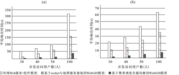
In order to improve the concurrent access performance of WebGIS, this paper studies deficiencies of load-balancing technologies in the current WebGIS and analyzes the necessity and feasibility to solve load-balancing in WebGIS based on collaborative tasks clustering technology under the situation of large volume of concurrent accesses. A WebGIS model based on cluster scheduling load-balancing algorithm is proposed. The key is to research the cluster scheduling load-balancing algorithm. A test-bed is established. A series of test results prove that the model has good global load balancing performance.
In order to improve the concurrent access performance of WebGIS, this paper studies deficiencies of load-balancing technologies in the current WebGIS and analyzes the necessity and feasibility to solve load-balancing in WebGIS based on collaborative tasks clustering technology under the situation of large volume of concurrent accesses. A WebGIS model based on cluster scheduling load-balancing algorithm is proposed. The key is to research the cluster scheduling load-balancing algorithm. A test-bed is established. A series of test results prove that the model has good global load balancing performance.


2010, 35(3): 415-420.
doi: 10.3799/dqkx.2010.049
Abstract:
To improve the efficiency for space distance semi-join based on external approximation index, a method of spatial distance semi-join based on multi-approximate index is proposed. The constraint relationship of distance and the number of spatial objects during processing semi-join are deduced based on taking advantage of characteristics of multi-approximate index structure. And these are used during spatial distance semi-join to reduce the number of spatial objects needed to process during refine filter step. A series of tests and verifications indicate that the new method of spatial distance semi-join is valid and the performance of index based on multi-approximation is more effective than the index based on external approximation during processing spatial distance semi-join.
To improve the efficiency for space distance semi-join based on external approximation index, a method of spatial distance semi-join based on multi-approximate index is proposed. The constraint relationship of distance and the number of spatial objects during processing semi-join are deduced based on taking advantage of characteristics of multi-approximate index structure. And these are used during spatial distance semi-join to reduce the number of spatial objects needed to process during refine filter step. A series of tests and verifications indicate that the new method of spatial distance semi-join is valid and the performance of index based on multi-approximation is more effective than the index based on external approximation during processing spatial distance semi-join.

2010, 35(3): 421-425.
doi: 10.3799/dqkx.2010.050
Abstract:
Fractal net evolution approach (FNEA) is a relatively mature one among the object-oriented image segmentation algorithms, but its efficiency is to be improved. Quad-Tree segmentation is a kind of effective image segmentation method. In this paper, an improved object oriented multi-scale image segmentation method based on the quad-tree pre-segmentation and FNEA is introduced. The experiment shows that the effect of its segmentation result is almost the same as that of traditional FNEA method. Moreover, It saves time.
Fractal net evolution approach (FNEA) is a relatively mature one among the object-oriented image segmentation algorithms, but its efficiency is to be improved. Quad-Tree segmentation is a kind of effective image segmentation method. In this paper, an improved object oriented multi-scale image segmentation method based on the quad-tree pre-segmentation and FNEA is introduced. The experiment shows that the effect of its segmentation result is almost the same as that of traditional FNEA method. Moreover, It saves time.


2010, 35(3): 426-430,489.
doi: 10.3799/dqkx.2010.051
Abstract:
In the distributed environment, each node usually has to share the geographic metadata of other nodes. In order to achieve the target and ensure high independence and autonomy of each node, based on "Information integration and sharing of land resources platform mechanism" project and special message queue designed, we launch a data synchronization mechanism based on XML Web Service. Through the synchronization mechanism, it weakens the concept of center and nodes, achieves non-center structure under the physical structure and makes each node share data actively and store different copies of the same data, achieving the target of geographic metadata in a better way.
In the distributed environment, each node usually has to share the geographic metadata of other nodes. In order to achieve the target and ensure high independence and autonomy of each node, based on "Information integration and sharing of land resources platform mechanism" project and special message queue designed, we launch a data synchronization mechanism based on XML Web Service. Through the synchronization mechanism, it weakens the concept of center and nodes, achieves non-center structure under the physical structure and makes each node share data actively and store different copies of the same data, achieving the target of geographic metadata in a better way.


2010, 35(3): 431-436.
doi: 10.3799/dqkx.2010.052
Abstract:
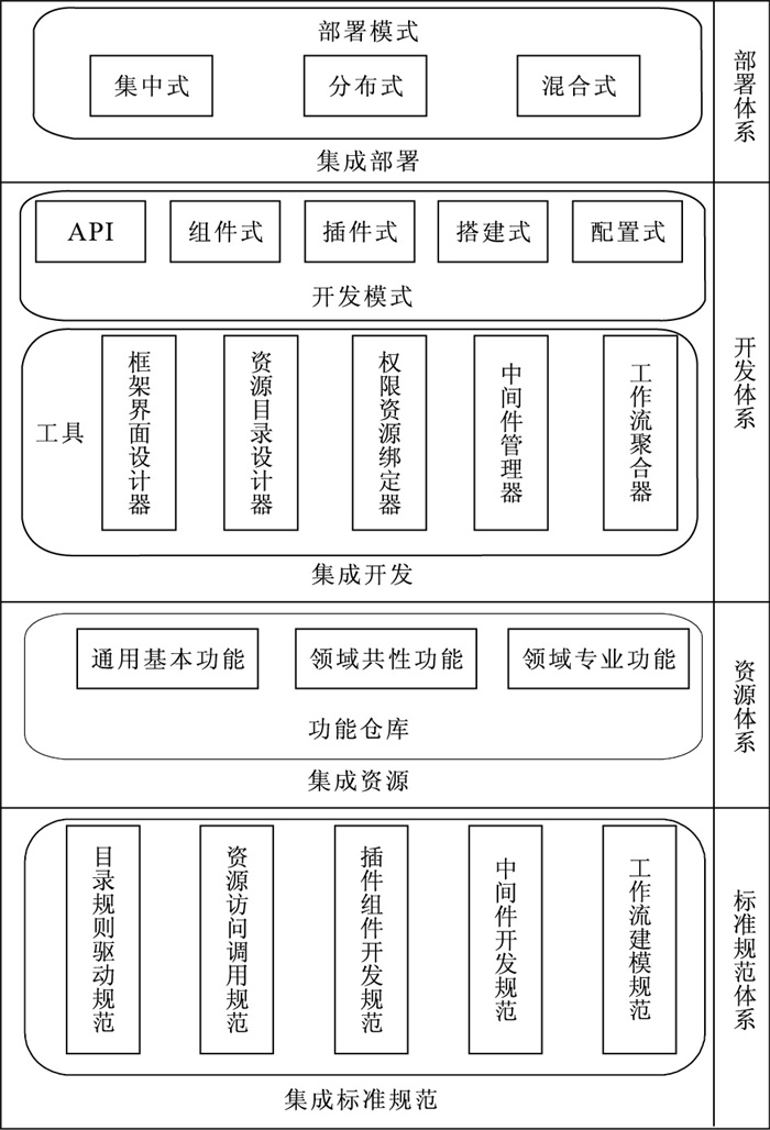
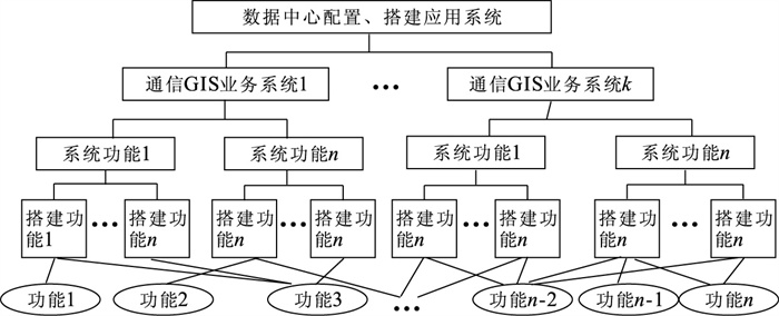
This paper presents a development system chain to build integration environment providing resource integration management, function modeling, and application system building. General model for developing, deploying, and extending business-oriented spatial information service is introduced. This chain includes four elements, classified as standards and norms system, resources system, development system, and deployment system. Based on a flexible architecture termed suspended inversion model, the chain introduces the conception of development model and function warehouse, defines the hierarchical relation of service development and user group, integrates a set of norms including service development and resources management, a set of tools including service development and maintenance, and deployment model, and finally maximizes its applications.
This paper presents a development system chain to build integration environment providing resource integration management, function modeling, and application system building. General model for developing, deploying, and extending business-oriented spatial information service is introduced. This chain includes four elements, classified as standards and norms system, resources system, development system, and deployment system. Based on a flexible architecture termed suspended inversion model, the chain introduces the conception of development model and function warehouse, defines the hierarchical relation of service development and user group, integrates a set of norms including service development and resources management, a set of tools including service development and maintenance, and deployment model, and finally maximizes its applications.


2010, 35(3): 437-443.
doi: 10.3799/dqkx.2010.053
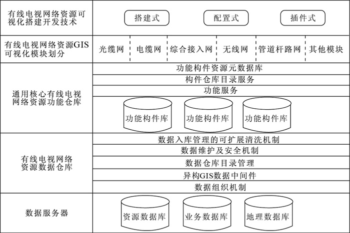
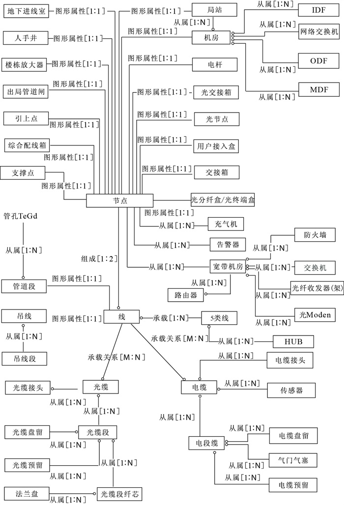
Abstract:
To avoid repeated investment and redundant construction risk of CATV network operators, this paper designes a cable television network resource management platform based on MapGIS data center technology. The platform encapsulates common functions and resource data model in CATV network resource management, supporting the zero-programming, smart combination, quick to build CATV network resource applications based on GIS. The project validation proves that the development of GIS application system in similar industries, can save 80% of development costs with guaranteed quality.
To avoid repeated investment and redundant construction risk of CATV network operators, this paper designes a cable television network resource management platform based on MapGIS data center technology. The platform encapsulates common functions and resource data model in CATV network resource management, supporting the zero-programming, smart combination, quick to build CATV network resource applications based on GIS. The project validation proves that the development of GIS application system in similar industries, can save 80% of development costs with guaranteed quality.


2010, 35(3): 444-452.
doi: 10.3799/dqkx.2010.054
Abstract:
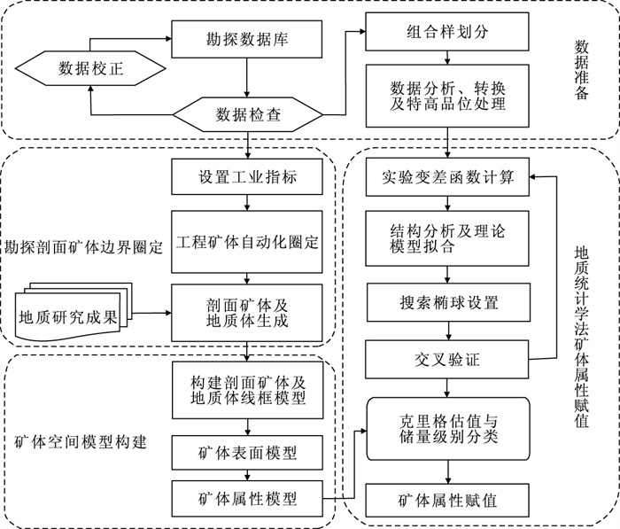
To make up the deficiencies of existing digital ore deposit modeling methods and its applications in mineral survey data managements, a method is advanced for ore deposit modeling in geological mineral survey data management. The method is featured with the following improvement: (1) Original mineral survey data standard informationization; (2) Automatic engineering orebody delineation by multi-confine and comlpex industry index; (3) Orebody joint and extrapolate mode in profile map based on semantic identification; (4) Orebody surface modeling by orebody wireframe model contours in profile map; (5) Orebody spatial attribute modeling by TIN+Octree data structure and geostatistics, and its applications in mineral reserve estimation. So that it can enhance research precision on geological mineral survey and provide the credible orebody model for mining design.
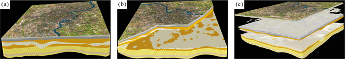
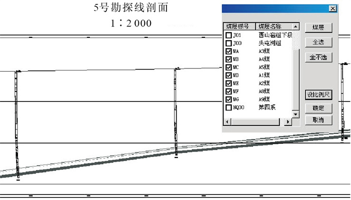
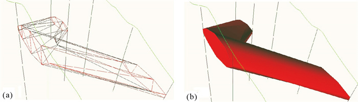
To make up the deficiencies of existing digital ore deposit modeling methods and its applications in mineral survey data managements, a method is advanced for ore deposit modeling in geological mineral survey data management. The method is featured with the following improvement: (1) Original mineral survey data standard informationization; (2) Automatic engineering orebody delineation by multi-confine and comlpex industry index; (3) Orebody joint and extrapolate mode in profile map based on semantic identification; (4) Orebody surface modeling by orebody wireframe model contours in profile map; (5) Orebody spatial attribute modeling by TIN+Octree data structure and geostatistics, and its applications in mineral reserve estimation. So that it can enhance research precision on geological mineral survey and provide the credible orebody model for mining design.


2010, 35(3): 453-458.
doi: 10.3799/dqkx.2010.055
Abstract:
For the purpose of rational exploitation of mineral resources and effective monitor of ecological environment in mining areas, we did experiments about land-use classification of the high spatial resolution airborne image from a mining area in Heng County of Guangxi province using element-oriented method. By optimizing the evolution of multi-scale fractal network segment process, two levels of image elements were extracted efficiently. Based on the multi-scale image elements, the land-use classification knowledge base of the study area was established through analyzing spectral, spatial and class-relation features in this area. The classification precision improved from 53% to 90% by decision supporting fuzzy logic reasoning of the knowledge base. The experiments show that the element-oriented method can obtain high precision land-use classification for taking full advantage of various features of the mining area from the high spatial resolution image.
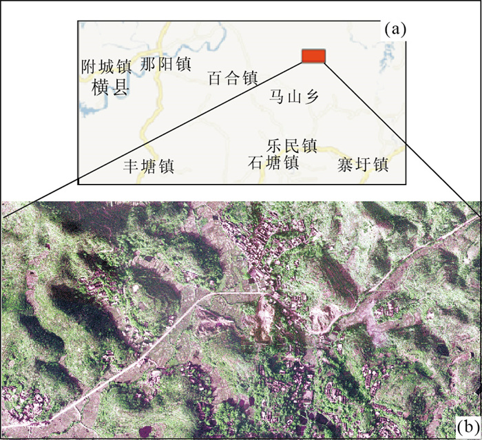
For the purpose of rational exploitation of mineral resources and effective monitor of ecological environment in mining areas, we did experiments about land-use classification of the high spatial resolution airborne image from a mining area in Heng County of Guangxi province using element-oriented method. By optimizing the evolution of multi-scale fractal network segment process, two levels of image elements were extracted efficiently. Based on the multi-scale image elements, the land-use classification knowledge base of the study area was established through analyzing spectral, spatial and class-relation features in this area. The classification precision improved from 53% to 90% by decision supporting fuzzy logic reasoning of the knowledge base. The experiments show that the element-oriented method can obtain high precision land-use classification for taking full advantage of various features of the mining area from the high spatial resolution image.


2010, 35(3): 459-462.
doi: 10.3799/dqkx.2010.056
Abstract:
This paper studies the algorithm of auto-creation of logic diagrams with or without orientation of telecommunication to overcome the maintenance difficulty of hand-drawn logic diagram telecommunications. This algorithm initializes the graph by database, traverses the graph by deep-search-first method, and sets the vertex's offset of every line. At a result, a diagram is created without needless intercrossing by adjusting the line's order. This method avoids getting this diagram manually. Therefore this algorithm works when the diagram is of normal scale.
This paper studies the algorithm of auto-creation of logic diagrams with or without orientation of telecommunication to overcome the maintenance difficulty of hand-drawn logic diagram telecommunications. This algorithm initializes the graph by database, traverses the graph by deep-search-first method, and sets the vertex's offset of every line. At a result, a diagram is created without needless intercrossing by adjusting the line's order. This method avoids getting this diagram manually. Therefore this algorithm works when the diagram is of normal scale.


2010, 35(3): 463-470.
doi: 10.3799/dqkx.2010.057
Abstract:
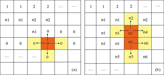
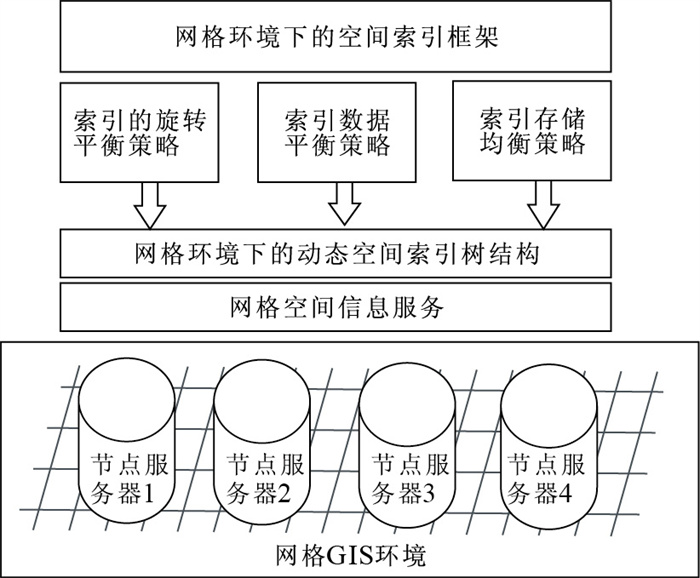
In order to improve the efficiency of parallel processing of a spatial mass data under the distributed parallel computing grid environment, this paper presents a new grid slot hash parallel spatial index GSHR-Tree structure established with the parallel spatial indexing mechanism. Based on the hash table and dynamic spatial slot, we have improved the structure of the classical parallel R-tree index. The GSHR-Tree index makes full use of the good qualities of R-Tree and hash data structure. A new parallel spatial index is constructed to meet the needs of parallel grid computing about the magnanimous spatial data in the distributed network. This arithmetic splits space into multi-slots by multiplying and reverting and maps these slots to sites in distributed and parallel system. Each site constructs the spatial objects in its spatial slot into an R-tree. On the basis of this tree structure, the index data is distributed among multiple nodes in the grid networks by using large node R-tree method. Instead of spatial object's recursive comparison where original R-tree has been used, the algorithm builds the spatial index by applying binary code operation in which computer runs more efficiently, and extends dynamic hash code for bit comparison, using the system response time of the parallel processing of spatial scope query algorithm as the performance evaluation factor. The result of the simulated the experiments shows GSHR-Tree is performed to prove the reasonable design and the high performance of the indexing structure presented in the paper.
In order to improve the efficiency of parallel processing of a spatial mass data under the distributed parallel computing grid environment, this paper presents a new grid slot hash parallel spatial index GSHR-Tree structure established with the parallel spatial indexing mechanism. Based on the hash table and dynamic spatial slot, we have improved the structure of the classical parallel R-tree index. The GSHR-Tree index makes full use of the good qualities of R-Tree and hash data structure. A new parallel spatial index is constructed to meet the needs of parallel grid computing about the magnanimous spatial data in the distributed network. This arithmetic splits space into multi-slots by multiplying and reverting and maps these slots to sites in distributed and parallel system. Each site constructs the spatial objects in its spatial slot into an R-tree. On the basis of this tree structure, the index data is distributed among multiple nodes in the grid networks by using large node R-tree method. Instead of spatial object's recursive comparison where original R-tree has been used, the algorithm builds the spatial index by applying binary code operation in which computer runs more efficiently, and extends dynamic hash code for bit comparison, using the system response time of the parallel processing of spatial scope query algorithm as the performance evaluation factor. The result of the simulated the experiments shows GSHR-Tree is performed to prove the reasonable design and the high performance of the indexing structure presented in the paper.


2010, 35(3): 471-474.
doi: 10.3799/dqkx.2010.058
Abstract:
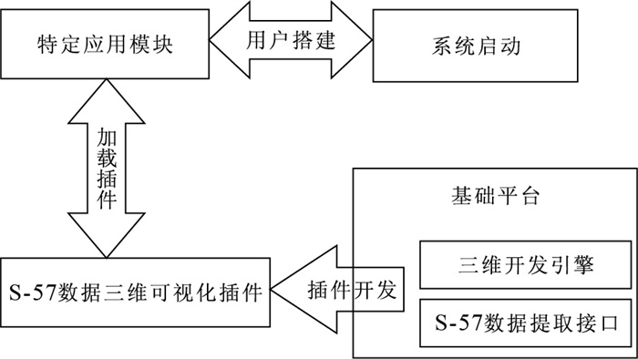
S-57 is the HIO standard for digital hydrographic data, which now has become an important means of information management for the global hydrographic departments. Additionally, the technology of 3D modeling and visualization has been widely used in the information construction of the hydrographic management. And it is urgent to work out the technical issue in the maritime management system as how to extract the useful information from the S-57 format data and realize the 3D modeling and visualization. In order to solve these problems, this paper presents the model of 3D visualization of the sea based S-57 standard, using the spatial interpolation techniques to optimize the three-dimensional terrain data of the digital hydrographic management, providing the interaction interface of 3D objects, truthfully displaying the sailing condition in the sea area and electronic chart object's spatial information, which offers an important reference to the sea rescue and the maritime management.
S-57 is the HIO standard for digital hydrographic data, which now has become an important means of information management for the global hydrographic departments. Additionally, the technology of 3D modeling and visualization has been widely used in the information construction of the hydrographic management. And it is urgent to work out the technical issue in the maritime management system as how to extract the useful information from the S-57 format data and realize the 3D modeling and visualization. In order to solve these problems, this paper presents the model of 3D visualization of the sea based S-57 standard, using the spatial interpolation techniques to optimize the three-dimensional terrain data of the digital hydrographic management, providing the interaction interface of 3D objects, truthfully displaying the sailing condition in the sea area and electronic chart object's spatial information, which offers an important reference to the sea rescue and the maritime management.


2010, 35(3): 475-479.
doi: 10.3799/dqkx.2010.059
Abstract:
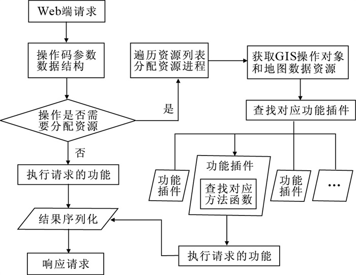
A solution of GIS Server in multi-process mode based on Plug-in technology is introduced in this paper to make it much steadier, and more convenient for extending. The server model is constituted with scheduler and management module and exe process, and solves the problem of simultaneous operations by multi-users with the method of assigning data resources. According to executive functions, the model is divided into five sub-modules in detail: server management level, operation level, user management level, exe process and map level. In the aspect of function realization, the author splits the process of executing functions based on the flow of responding the requests, and brings forward the design idea of packing the operations using plug-in technology, which makes the functions independent of server. This model achieves the balance load so that the server can run more steadily, and develops the applications more efficiently with plug-in technology and Web Service technology.
A solution of GIS Server in multi-process mode based on Plug-in technology is introduced in this paper to make it much steadier, and more convenient for extending. The server model is constituted with scheduler and management module and exe process, and solves the problem of simultaneous operations by multi-users with the method of assigning data resources. According to executive functions, the model is divided into five sub-modules in detail: server management level, operation level, user management level, exe process and map level. In the aspect of function realization, the author splits the process of executing functions based on the flow of responding the requests, and brings forward the design idea of packing the operations using plug-in technology, which makes the functions independent of server. This model achieves the balance load so that the server can run more steadily, and develops the applications more efficiently with plug-in technology and Web Service technology.


2010, 35(3): 480-484.
doi: 10.3799/dqkx.2010.060
Abstract:
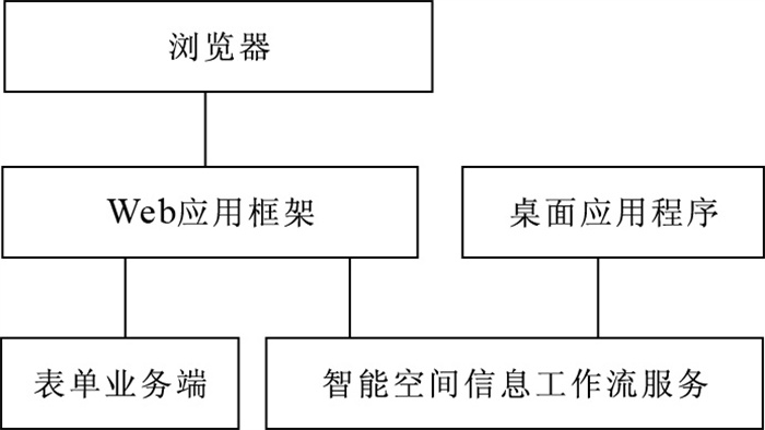
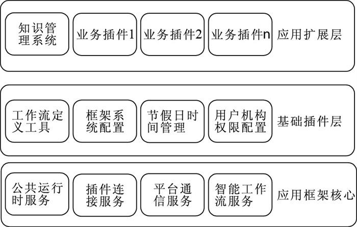
Since it's difficult to combine geographic information system (GIS) service and application system in multi-level flexibly and to build GIS Web application system quickly with the traditional framework and development method, we propose a new GIS application framework based service-oriented architecture (SOA) by introducing workflow into spatial information process, as well as simplifying user's development work through a service-oriented business model. On this basis, we have implemented a GIS application framework composed of the following three parts: system framework, workflow engine and forms. It has been proved in practice that SOA can offer various GIS services with different granularities and different function packages based on GIS workflow, as well as build business system quickly with form based on SOA. This model offers a new method to GIS development.
Since it's difficult to combine geographic information system (GIS) service and application system in multi-level flexibly and to build GIS Web application system quickly with the traditional framework and development method, we propose a new GIS application framework based service-oriented architecture (SOA) by introducing workflow into spatial information process, as well as simplifying user's development work through a service-oriented business model. On this basis, we have implemented a GIS application framework composed of the following three parts: system framework, workflow engine and forms. It has been proved in practice that SOA can offer various GIS services with different granularities and different function packages based on GIS workflow, as well as build business system quickly with form based on SOA. This model offers a new method to GIS development.

2010, 35(3): 485-489.
doi: 10.3799/dqkx.2010.061
Abstract:
Optimizing the RPC (Rational Polynomial Coefficient) model can improve the positioning accuracy of the RPC correction model. Tacking an IRS-P5 image for example, in the cases of using 0-9 control points or using compensation model, we analyze the accuracy change of the image ortho correction. The results show that the accuracy can be improved from 55.80 m to 5.80 m when we increase the control points from 0 to 1; while the accuracy is close to 5.0 m when the number of control points is more than 5; In addition, the accuracy reach 4.0 m when we use 1 control point and compensation model. It indicates that the accuracy of ortho correction of RPC modal can substantially increase by adding control points, also can reach high correction accuracy using compensation model in the cases of missing control point.
Optimizing the RPC (Rational Polynomial Coefficient) model can improve the positioning accuracy of the RPC correction model. Tacking an IRS-P5 image for example, in the cases of using 0-9 control points or using compensation model, we analyze the accuracy change of the image ortho correction. The results show that the accuracy can be improved from 55.80 m to 5.80 m when we increase the control points from 0 to 1; while the accuracy is close to 5.0 m when the number of control points is more than 5; In addition, the accuracy reach 4.0 m when we use 1 control point and compensation model. It indicates that the accuracy of ortho correction of RPC modal can substantially increase by adding control points, also can reach high correction accuracy using compensation model in the cases of missing control point.


2010, 35(3): 490-494.
doi: 10.3799/dqkx.2010.062
Abstract:
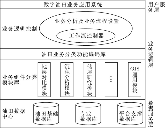
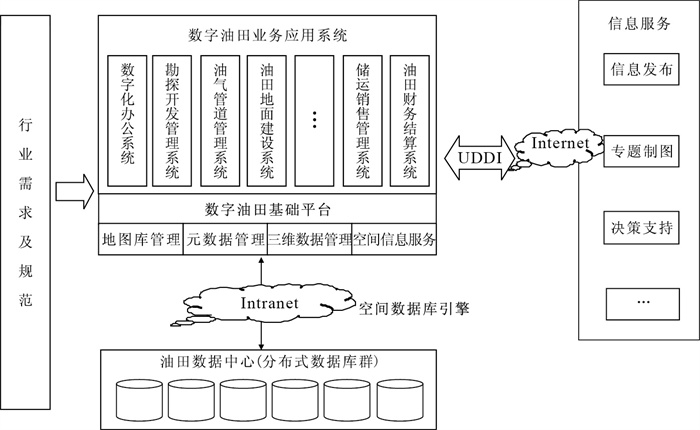
The current geographic information system (GIS) fundamental platform can not provide efficient support for digitalizing oilfield. It is necessary to build an oil-application-oriented fundamental platform. This paper carries out the key technology research, such as management of unified storage of multi-type oilfield data, multiple level magnanimity distributed oilfield data, integration of application model and GIS platform, construction of the cooperation work platform. A framework of digital oilfield fundamental platform is proposed. It offers a breakthrough GIS applications in petroleum industry. The research and development of the fundamental platform also extends GIS applications.
The current geographic information system (GIS) fundamental platform can not provide efficient support for digitalizing oilfield. It is necessary to build an oil-application-oriented fundamental platform. This paper carries out the key technology research, such as management of unified storage of multi-type oilfield data, multiple level magnanimity distributed oilfield data, integration of application model and GIS platform, construction of the cooperation work platform. A framework of digital oilfield fundamental platform is proposed. It offers a breakthrough GIS applications in petroleum industry. The research and development of the fundamental platform also extends GIS applications.


2010, 35(3): 495-500.
doi: 10.3799/dqkx.2010.063
Abstract:
Due to rapid development of intelligent terminals and Internet, the mobile spatial information services becomes an important part of Digital City and Digital Earth, and the kinds of embedded geographic information system (GIS) based on positioning and navigation become the main form of the services. This paper analyzes the characteristics of modern spatial information services, with hierarchical modular design method. The modules, such as portable GIS-based abstraction layer, multiple data storage model, electronic map display engine and high-performance applications service engine is introduced. A portable embedded GIS platform is designed, which provides a practical solution for popular application development of mobile spatial information service.
Due to rapid development of intelligent terminals and Internet, the mobile spatial information services becomes an important part of Digital City and Digital Earth, and the kinds of embedded geographic information system (GIS) based on positioning and navigation become the main form of the services. This paper analyzes the characteristics of modern spatial information services, with hierarchical modular design method. The modules, such as portable GIS-based abstraction layer, multiple data storage model, electronic map display engine and high-performance applications service engine is introduced. A portable embedded GIS platform is designed, which provides a practical solution for popular application development of mobile spatial information service.


2010, 35(3): 501-506.
doi: 10.3799/dqkx.2010.064
Abstract:
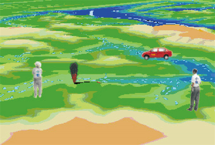
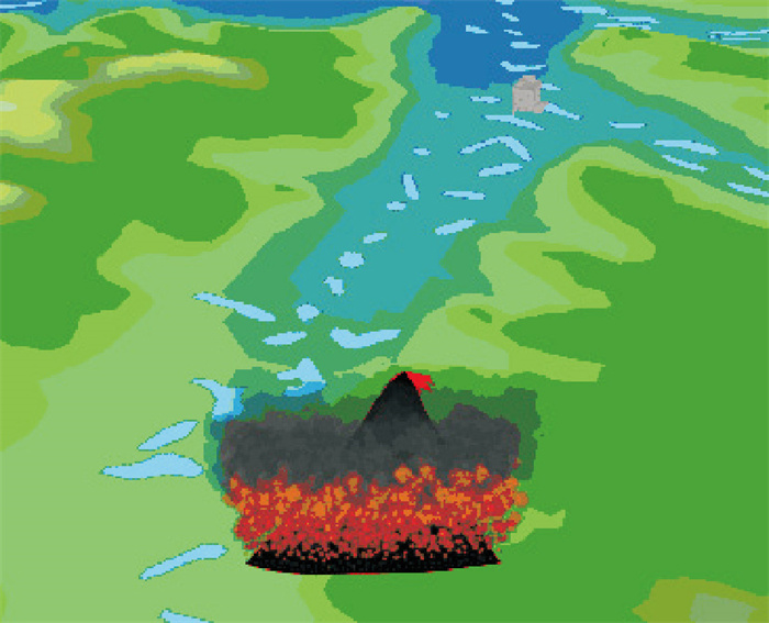
Quick and accurate monitoring and positioning forest fire can help save precious time in fire fighting, reduce loss of forest resources and decrease environmental pollution. In order to achieve the goal, geographic information system (GIS) and remote sensing (RS) were used, and giver a real exploring example about using MapGIS as an explored platform, designing and realizing "forest fire fighting monitoring and warning system". As two popular monitoring and positioning technologies, remote sensing image positioning and video image positioning take advantage of each other in both macro and micro perspectives. Fire rating prediction provides a reference for monitoring the focus, and fire inference analysis of the close combination of meteorological information and vegetation information simulates the spread of fire. The exploring example proves that GIS has advantage of visibility in forest fire fighting monitoring, especially, its strong functions about spatial analysis promotes informational and scientific forest fire management.
Quick and accurate monitoring and positioning forest fire can help save precious time in fire fighting, reduce loss of forest resources and decrease environmental pollution. In order to achieve the goal, geographic information system (GIS) and remote sensing (RS) were used, and giver a real exploring example about using MapGIS as an explored platform, designing and realizing "forest fire fighting monitoring and warning system". As two popular monitoring and positioning technologies, remote sensing image positioning and video image positioning take advantage of each other in both macro and micro perspectives. Fire rating prediction provides a reference for monitoring the focus, and fire inference analysis of the close combination of meteorological information and vegetation information simulates the spread of fire. The exploring example proves that GIS has advantage of visibility in forest fire fighting monitoring, especially, its strong functions about spatial analysis promotes informational and scientific forest fire management.