2010 Vol. 35, No. 5
Display Method:
2010, 35(5): 697-712.
doi: 10.3799/dqkx.2010.085
 PDF 2780KB
Abstract:
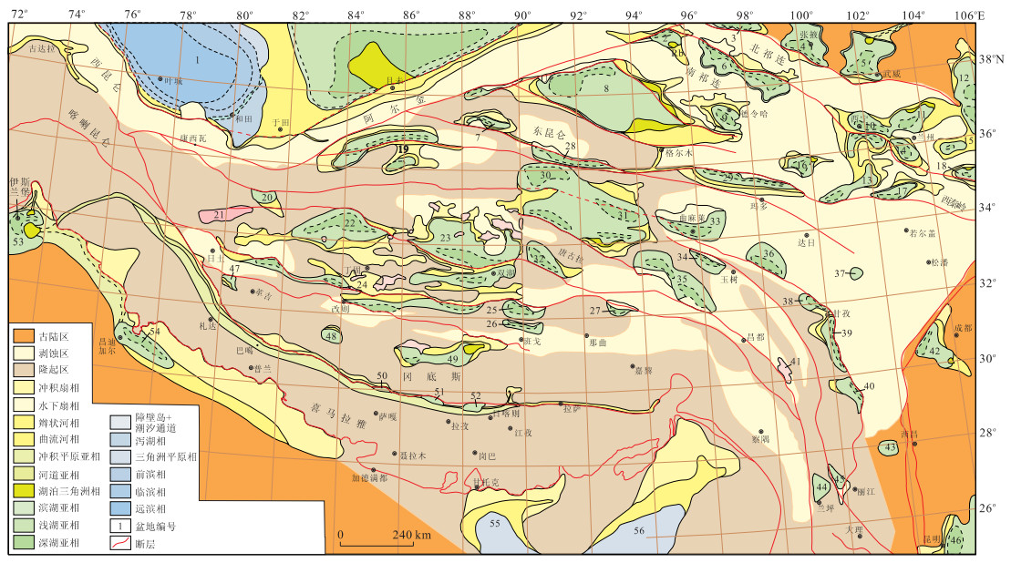
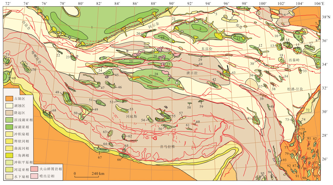
By doing an integrated research on the types of 98 remnant basins, tectonic setting and lithostratigraphic sequence, we studied the evolution of tectonic lithofacies paleogeography of the Paleocene—Eocene, Oligocene, Miocene and Pliocene of Qinghai-Tibet plateau, dividing it into four stages: (1) The Paleocene to Eocene characterized by an uplift and erosional area in Songpan—Garzê and Gangdisê, depressed basins (lakes and pluvial plain) in eastern Tarim, Qaidam, Qiangtang and Hoh Xil, and Neo-Tethys sea in western and southern Qinghai-Tibet plateau; (2) The Oligocene characterized by an uplift area in Gangdisê-Himalaya and Karakorum (marked by the absence of the sediments), rivers (originated from east and flew to west) in Yarlung Zangbo Jiang (marked by the deposition of Dazhuka conglomerate), an uplift and erosional area in western Kunlun and Songpan-Garzê, and depressed basins (lakes) in Tarim, Qaidam, Qiangtang and Hoh Xil. Besides, it is also featured with a depressed littoral and neritic basin in southwestern Tarim and the termination of marine-facies deposition at the end of the Oligocene; (3) The Miocene characterized with the widespread of regional unconformity in the plateau, the overall uplift of the plateau in its adjacent area ca. 23 Ma, depressed basins (lakes) in Tarim, Qaidam, Xining-Nanzhou, Qiangtang, Hoh Xil, lacustrine-facies deposition expanding to its peak in the plateau and its adjacent area ca. 18—13 Ma, and the formation of south-north fault basins in southern Tibet ca. 13—10 Ma, all indicating that the plateau uplifted to its peak and began to collapse; (4) The Pliocene characterized by an uplift and erosional area in most part of the plateau except in Hoh Xil-Qiangtang, Tarim and Qaidam. The continuing uplift and intensive fault in plateau elevated and divided the original large basin into small basins. The lacustrine-facies deposition prominently shrank and boulderstones accumulated, indicating a response to the overall uplift of the plateau. The plateau, which was higher in east and lower in west in physiognomy in the Paleogene, experienced a process of uneven uplift and sag in the Neogene and finally became higher in west and lower in east in physiognomy. This process indicates that a great physiognomy-reverse event happened in the Qinghai-Tibet plateau.
By doing an integrated research on the types of 98 remnant basins, tectonic setting and lithostratigraphic sequence, we studied the evolution of tectonic lithofacies paleogeography of the Paleocene—Eocene, Oligocene, Miocene and Pliocene of Qinghai-Tibet plateau, dividing it into four stages: (1) The Paleocene to Eocene characterized by an uplift and erosional area in Songpan—Garzê and Gangdisê, depressed basins (lakes and pluvial plain) in eastern Tarim, Qaidam, Qiangtang and Hoh Xil, and Neo-Tethys sea in western and southern Qinghai-Tibet plateau; (2) The Oligocene characterized by an uplift area in Gangdisê-Himalaya and Karakorum (marked by the absence of the sediments), rivers (originated from east and flew to west) in Yarlung Zangbo Jiang (marked by the deposition of Dazhuka conglomerate), an uplift and erosional area in western Kunlun and Songpan-Garzê, and depressed basins (lakes) in Tarim, Qaidam, Qiangtang and Hoh Xil. Besides, it is also featured with a depressed littoral and neritic basin in southwestern Tarim and the termination of marine-facies deposition at the end of the Oligocene; (3) The Miocene characterized with the widespread of regional unconformity in the plateau, the overall uplift of the plateau in its adjacent area ca. 23 Ma, depressed basins (lakes) in Tarim, Qaidam, Xining-Nanzhou, Qiangtang, Hoh Xil, lacustrine-facies deposition expanding to its peak in the plateau and its adjacent area ca. 18—13 Ma, and the formation of south-north fault basins in southern Tibet ca. 13—10 Ma, all indicating that the plateau uplifted to its peak and began to collapse; (4) The Pliocene characterized by an uplift and erosional area in most part of the plateau except in Hoh Xil-Qiangtang, Tarim and Qaidam. The continuing uplift and intensive fault in plateau elevated and divided the original large basin into small basins. The lacustrine-facies deposition prominently shrank and boulderstones accumulated, indicating a response to the overall uplift of the plateau. The plateau, which was higher in east and lower in west in physiognomy in the Paleogene, experienced a process of uneven uplift and sag in the Neogene and finally became higher in west and lower in east in physiognomy. This process indicates that a great physiognomy-reverse event happened in the Qinghai-Tibet plateau.


2010, 35(5): 713-727.
doi: 10.3799/dqkx.2010.086.
Abstract:
In this paper we deduce the expanding and forming processes of the Qinghai-Tibet plateau by summarizing the spatio-temporal difference of uplift during Cenozoic. The uplift in the Paleocene-Eocene(65—35 Ma) mainly showed rock uplift driven by thrusting in different crust levels. The major denudation areas included the Tianshuihai, the Qilian Shan, Songpan-Ganzi-Bayan Har and Gangdise etc. There appeared alluvial-pluvial plain with low elevation in the Qiangtang-Hoh Xil-Qaidam and Xining-Linxia areas, and maritime space in the western Kunlun and Himalaya areas. In the Late Oligocene-Early Miocene (25—17 Ma), intensive thrusting induced increased crust thickness in the southern Tibet (including the Gangdese and the northern Himalayan belt). Then in about 17—12 Ma, crust isostatic compensation drove the southern Tibet to reach the current high elevation. Foreland basin developed in the Qiangtang-Hoh Xil area, and basin-range lelief emerged in the northern margin of the Qinghai-Tibet plateau during the late Oligocene-early Miocene. In the middle-late Miocene (13—7 Ma), centering in the southern Tibet (the Gangdise-northern Himalayan belt), the plateau grew and expanded northwardly. The basin in the Qiangtang-Hoh Xil area uplifted regionally and reached quite high altitude. In the northern margin of the Qinghai-Tibet plateau, a series of mountains ulteriorly popped up to the basin. The modern basin-range relief formed by and large but still kept lower average attitude. Since Pliocene, the plateau has been expanding northward rapidly. Rapid unitary surface uplift has been happening in the vast area of the Qiangtang-Hoh Xil-Songpan-Garzê-Bayan Har, forming the hinterland of the current plateau. In the northern edge of the plateau, the series of mountains also have been acutely uplifting and expanding forward adjacent basin, and average attitude has also been going up. In the Himalaya, the southern edge of the plateau, the relief contrast has been strengthening by thrusting and eroding. A series of high mountains finalize, with super-elevation of more than 7 000 m, such as the Qomolangma.
In this paper we deduce the expanding and forming processes of the Qinghai-Tibet plateau by summarizing the spatio-temporal difference of uplift during Cenozoic. The uplift in the Paleocene-Eocene(65—35 Ma) mainly showed rock uplift driven by thrusting in different crust levels. The major denudation areas included the Tianshuihai, the Qilian Shan, Songpan-Ganzi-Bayan Har and Gangdise etc. There appeared alluvial-pluvial plain with low elevation in the Qiangtang-Hoh Xil-Qaidam and Xining-Linxia areas, and maritime space in the western Kunlun and Himalaya areas. In the Late Oligocene-Early Miocene (25—17 Ma), intensive thrusting induced increased crust thickness in the southern Tibet (including the Gangdese and the northern Himalayan belt). Then in about 17—12 Ma, crust isostatic compensation drove the southern Tibet to reach the current high elevation. Foreland basin developed in the Qiangtang-Hoh Xil area, and basin-range lelief emerged in the northern margin of the Qinghai-Tibet plateau during the late Oligocene-early Miocene. In the middle-late Miocene (13—7 Ma), centering in the southern Tibet (the Gangdise-northern Himalayan belt), the plateau grew and expanded northwardly. The basin in the Qiangtang-Hoh Xil area uplifted regionally and reached quite high altitude. In the northern margin of the Qinghai-Tibet plateau, a series of mountains ulteriorly popped up to the basin. The modern basin-range relief formed by and large but still kept lower average attitude. Since Pliocene, the plateau has been expanding northward rapidly. Rapid unitary surface uplift has been happening in the vast area of the Qiangtang-Hoh Xil-Songpan-Garzê-Bayan Har, forming the hinterland of the current plateau. In the northern edge of the plateau, the series of mountains also have been acutely uplifting and expanding forward adjacent basin, and average attitude has also been going up. In the Himalaya, the southern edge of the plateau, the relief contrast has been strengthening by thrusting and eroding. A series of high mountains finalize, with super-elevation of more than 7 000 m, such as the Qomolangma.

2010, 35(5): 728-736.
doi: 10.3799/dqkx.2010.087
Abstract:
Clay mineralogy of sediments of the basins in different locations of the Qinghai-Tibet plateau was investigated to reveal the paleoclimate evolution in Tibet. Our results show that the planetary wind system prevailed over the Paleocene-Eocene in Tibet. A rapid cooling in Qaidam was found in ~36 Ma, prior to the global cooling event by ~2 Ma. In the Oligocene, paleoclimate was warm and dry and the temperature was lower than that of the previous stage. In Miocene-Pliocene period cooling event was found in ~21.5 Ma in Qaidam and Xunhua basins, northeastern Tibet. Climate change in 8-7 Ma occurred in the whole Qinghai-Tibet plateau. In Gyirong, southern Tibet and in Yecheng, western Tibet, smectite occurred in a certain amount in the sediments prior to ~1.8 Ma, indicating that climate was relatively humid in these regions prior to ~1.8 Ma though the climate changed into cool and dry in the Qinghai-Tibet plateau.
Clay mineralogy of sediments of the basins in different locations of the Qinghai-Tibet plateau was investigated to reveal the paleoclimate evolution in Tibet. Our results show that the planetary wind system prevailed over the Paleocene-Eocene in Tibet. A rapid cooling in Qaidam was found in ~36 Ma, prior to the global cooling event by ~2 Ma. In the Oligocene, paleoclimate was warm and dry and the temperature was lower than that of the previous stage. In Miocene-Pliocene period cooling event was found in ~21.5 Ma in Qaidam and Xunhua basins, northeastern Tibet. Climate change in 8-7 Ma occurred in the whole Qinghai-Tibet plateau. In Gyirong, southern Tibet and in Yecheng, western Tibet, smectite occurred in a certain amount in the sediments prior to ~1.8 Ma, indicating that climate was relatively humid in these regions prior to ~1.8 Ma though the climate changed into cool and dry in the Qinghai-Tibet plateau.


2010, 35(5): 737-746.
doi: 10.3799/dqkx.2010.088
Abstract:
The eastern Kunlun Orogen,as a southernmost morphotectonic transition belt of northward attenuation in topographic relief across the northern Tibetan plateau,is a key area in examining and recovering the processing and mechanisms of the far-field lithospheric deformation. In this paper,we try to illustrate the Early Cenozoic tectonic processing in the eastern Kunlun Orogen based on a systematic detrital zircon fission track (ZFT) study. It is indicated that widely distributed pre-Cenozoic strata in the study area experienced a ZFT differential resetting (~300—200℃) at around Paleocene-Eocene postdating their burying. Binomial fitting for the single grain ages yielded youngest peak ages (P1) that mainly fall between 42—59 Ma,which corresponds to a ceasing timing for the differential resetting of detrital,Regional thermal history. Relevant data concordantly suggest that the eastern Kunlun Orogen experienced a regional tectonic uplift in Paleocene-Eocene,which coincides with the timing of the Indian-Asian collision,which implies that the Kunlun Orogen occurred as a deformation frontier instantly as the Indian plate collided with Asian plate. Our study provides an evidence that the Tibetan lithosphere (or curst) deformation at early stage is essentially of rigid plate,rather than the present day of significant continuous deformation,which might be a combined result by several mechanisms of lithospheric layers thickened respectively.
The eastern Kunlun Orogen,as a southernmost morphotectonic transition belt of northward attenuation in topographic relief across the northern Tibetan plateau,is a key area in examining and recovering the processing and mechanisms of the far-field lithospheric deformation. In this paper,we try to illustrate the Early Cenozoic tectonic processing in the eastern Kunlun Orogen based on a systematic detrital zircon fission track (ZFT) study. It is indicated that widely distributed pre-Cenozoic strata in the study area experienced a ZFT differential resetting (~300—200℃) at around Paleocene-Eocene postdating their burying. Binomial fitting for the single grain ages yielded youngest peak ages (P1) that mainly fall between 42—59 Ma,which corresponds to a ceasing timing for the differential resetting of detrital,Regional thermal history. Relevant data concordantly suggest that the eastern Kunlun Orogen experienced a regional tectonic uplift in Paleocene-Eocene,which coincides with the timing of the Indian-Asian collision,which implies that the Kunlun Orogen occurred as a deformation frontier instantly as the Indian plate collided with Asian plate. Our study provides an evidence that the Tibetan lithosphere (or curst) deformation at early stage is essentially of rigid plate,rather than the present day of significant continuous deformation,which might be a combined result by several mechanisms of lithospheric layers thickened respectively.


2010, 35(5): 747-758.
doi: 10.3799/dqkx.2010.089
Abstract:
Zanda basin, formed in 9.5 Ma, is a Cenozoic sedimentary basin which lies in the converging range between the Himalaya tectonic belt and Karakorum tectonic belt. The Neogene strata in the basin are integrated, continuous and horizontal, showing a steady tectonic condition since Miocene. Analysis of sedimentary section indicates that ancient flow direction is northwest to southeast, while the modern flow direction of river—Xiangquan River is southeast to northwest, opposite to the ancient flow direction. Analysis of sendimentary construction and the composition of gravel displays that the sedimentary source is Ayila Rijyu northwest of Zanda basin. P1, P2 peak ages of Zanda basin are 12.6—15.3 Ma and 19.8—22.2 Ma respectively, which is consistent with the thermal event age of Ayila Rijyu. P1, P2 are of static peak ages, reflecting the rapid cooling event such as normal faulting based on the DZFT research of lag time and depositional time by Bernet and Garver. It is found by thermal history analysis of zircon and apatite fission track that the cooling rate of source area is 15.4 ℃/Ma at 32.6—9.5 Ma, and there was a rapid uplift and exhumation at the same time in the source region at 3.6—1.4 Ma reflected by zircon and apatite fission track ages. P1, P2 peak ages of modern river zircon samples of Karakurom belt are 10.5—10.8 Ma and 27.7—30.9 Ma respectively, showing the thermal events of Ayila Rijyu. Comparing the FT ages and depositional information of Zanda basin and orogenetic belt, it is shown that Zanda basin is Cenozoic sedimentary basin determined by southeast of Karakorum fault; Zanda basin and Ayila Rijyu Moutain are a typical coupling process by identical FT thermochronology structure.
Zanda basin, formed in 9.5 Ma, is a Cenozoic sedimentary basin which lies in the converging range between the Himalaya tectonic belt and Karakorum tectonic belt. The Neogene strata in the basin are integrated, continuous and horizontal, showing a steady tectonic condition since Miocene. Analysis of sedimentary section indicates that ancient flow direction is northwest to southeast, while the modern flow direction of river—Xiangquan River is southeast to northwest, opposite to the ancient flow direction. Analysis of sendimentary construction and the composition of gravel displays that the sedimentary source is Ayila Rijyu northwest of Zanda basin. P1, P2 peak ages of Zanda basin are 12.6—15.3 Ma and 19.8—22.2 Ma respectively, which is consistent with the thermal event age of Ayila Rijyu. P1, P2 are of static peak ages, reflecting the rapid cooling event such as normal faulting based on the DZFT research of lag time and depositional time by Bernet and Garver. It is found by thermal history analysis of zircon and apatite fission track that the cooling rate of source area is 15.4 ℃/Ma at 32.6—9.5 Ma, and there was a rapid uplift and exhumation at the same time in the source region at 3.6—1.4 Ma reflected by zircon and apatite fission track ages. P1, P2 peak ages of modern river zircon samples of Karakurom belt are 10.5—10.8 Ma and 27.7—30.9 Ma respectively, showing the thermal events of Ayila Rijyu. Comparing the FT ages and depositional information of Zanda basin and orogenetic belt, it is shown that Zanda basin is Cenozoic sedimentary basin determined by southeast of Karakorum fault; Zanda basin and Ayila Rijyu Moutain are a typical coupling process by identical FT thermochronology structure.


2010, 35(5): 759-773.
doi: 10.3799/dqkx.2010.090
Abstract:
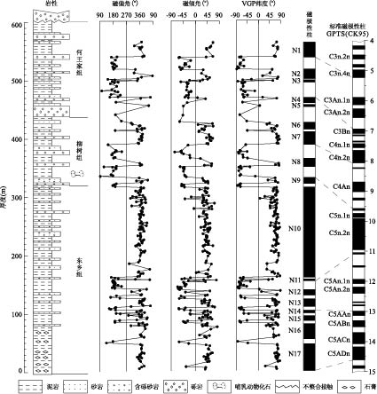
The Gyirong basin is one of east-west extensional basins distributed among the high Himalayas. The Late Cenozoic sequence is mainly Woma Formation, consisting of lacustrine and fluvial deposits, from which a Hipparion fauna in 7 Ma was found. However, Danzengzhukang Formation is newly found at the base of the section attributed to alluvial sequence. The zircon and apatite fission track thermochronology shows that eroded source experienced tectonic thermal event at 12-11 Ma, and early activity of the east boundary normal fault of the basin occurred during 13.4±1.9 Ma. Based on the previous paleomagnetostratigraphic researches of the basin, the age interval of the section is most reasonably determined as between 10 and 1.67 Ma. Through abundant palynological analyses, 3 palynological zones and 9 palynological assemblages and vegetable types are recognized, and 3 phases of paleoclimatic changes are revealed: (1) 10.0-6.7 Ma, correlating with palynological zone Ⅰ and assemblages 1-2, it was warm and damp-dry coniferous-leaved and broad-leaved mixed forests, but became cool and humid during 9.5-7.0 Ma. (2) 6.7-3.3 Ma, correlating with palynological zone Ⅱ and assemblages 3-7, it turned cold and arid deciduous coniferous-leaved forests, marked by the increase in the cold-tolerant tree taxa and drought-tolerant herb taxa, but the relative increase of broad-leaved taxa suggests climate underwent warm and humid fluctuations during 5.0-4.3 Ma. (3) 3.30-1.67 Ma, correlating with palynological zone Ⅲ and assemblages 8-9, it got cool and damp-dry deciduous coniferous-leaved and broad-leaved mixed forests.
The Gyirong basin is one of east-west extensional basins distributed among the high Himalayas. The Late Cenozoic sequence is mainly Woma Formation, consisting of lacustrine and fluvial deposits, from which a Hipparion fauna in 7 Ma was found. However, Danzengzhukang Formation is newly found at the base of the section attributed to alluvial sequence. The zircon and apatite fission track thermochronology shows that eroded source experienced tectonic thermal event at 12-11 Ma, and early activity of the east boundary normal fault of the basin occurred during 13.4±1.9 Ma. Based on the previous paleomagnetostratigraphic researches of the basin, the age interval of the section is most reasonably determined as between 10 and 1.67 Ma. Through abundant palynological analyses, 3 palynological zones and 9 palynological assemblages and vegetable types are recognized, and 3 phases of paleoclimatic changes are revealed: (1) 10.0-6.7 Ma, correlating with palynological zone Ⅰ and assemblages 1-2, it was warm and damp-dry coniferous-leaved and broad-leaved mixed forests, but became cool and humid during 9.5-7.0 Ma. (2) 6.7-3.3 Ma, correlating with palynological zone Ⅱ and assemblages 3-7, it turned cold and arid deciduous coniferous-leaved forests, marked by the increase in the cold-tolerant tree taxa and drought-tolerant herb taxa, but the relative increase of broad-leaved taxa suggests climate underwent warm and humid fluctuations during 5.0-4.3 Ma. (3) 3.30-1.67 Ma, correlating with palynological zone Ⅲ and assemblages 8-9, it got cool and damp-dry deciduous coniferous-leaved and broad-leaved mixed forests.


2010, 35(5): 774-788.
doi: 10.3799/dqkx.2010.091
Abstract:
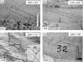
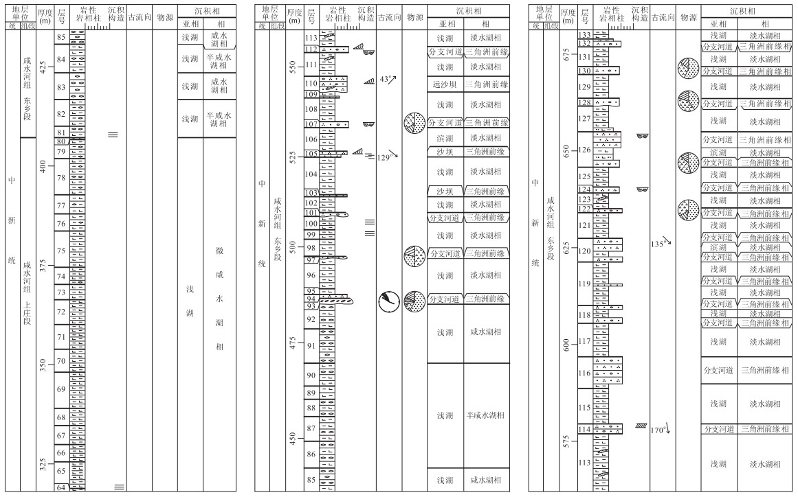
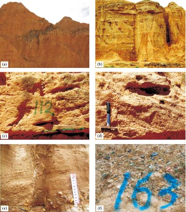
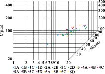
The measured section in the southern margin of Xunhua basin located at Yangjuangongbai-Xigoushangzhuang Village, Jishi Town, Xunhua County, Qinghai Province, consists of Miocene to Pliocene strata, named as Tala Fm., Xianshuihe Fm. (consisting of Zhongzhuang Mem., Shangzhuang Mem. and Dongxiang Mem.) and Linxia Fm. (consisting of Liushu Mem. and Hewangjia Mem.). The detailed research of sedimentary facies indicates that the depositional system of the section consists of alluvial fan facies (Tala Fm.), salt water lacustrine facies and delta front facies (Xianshuihe Fm.), lacustrine facies and delta front facies with underwater fan facies (Linxia Fm.) from bottom to top. Paleocurrent measurements obtained from the imbricated structures and cross-beddings show that the paleocurrent direction of section was SE-NW, except the Linxia Fm.. The sedimentary origin analysis demonstrates that the northern margin of the western Qinling thrust belt and the south margin of the Lajishan thrust belt had uplifted as denudation areas and provided deposits to the Xunhua basin. On the contrary, during the depositional stage of the Linxia Fm., the paleocurrent was NWW, indicating that the Jishi Mountain of the eastern edge of Xunhua basin had uplifted as a main denudation area during the Late Miocene-Pliocene. The results of the grain size probability accumulative curves and C-M patterns accord with the division of sedimentary facies mentioned above, and indicate that some tractive current developed in delta front facies and underwater fan facies.
The measured section in the southern margin of Xunhua basin located at Yangjuangongbai-Xigoushangzhuang Village, Jishi Town, Xunhua County, Qinghai Province, consists of Miocene to Pliocene strata, named as Tala Fm., Xianshuihe Fm. (consisting of Zhongzhuang Mem., Shangzhuang Mem. and Dongxiang Mem.) and Linxia Fm. (consisting of Liushu Mem. and Hewangjia Mem.). The detailed research of sedimentary facies indicates that the depositional system of the section consists of alluvial fan facies (Tala Fm.), salt water lacustrine facies and delta front facies (Xianshuihe Fm.), lacustrine facies and delta front facies with underwater fan facies (Linxia Fm.) from bottom to top. Paleocurrent measurements obtained from the imbricated structures and cross-beddings show that the paleocurrent direction of section was SE-NW, except the Linxia Fm.. The sedimentary origin analysis demonstrates that the northern margin of the western Qinling thrust belt and the south margin of the Lajishan thrust belt had uplifted as denudation areas and provided deposits to the Xunhua basin. On the contrary, during the depositional stage of the Linxia Fm., the paleocurrent was NWW, indicating that the Jishi Mountain of the eastern edge of Xunhua basin had uplifted as a main denudation area during the Late Miocene-Pliocene. The results of the grain size probability accumulative curves and C-M patterns accord with the division of sedimentary facies mentioned above, and indicate that some tractive current developed in delta front facies and underwater fan facies.


2010, 35(5): 789-802.
doi: 10.3799/dqkx.2010.092
Abstract:
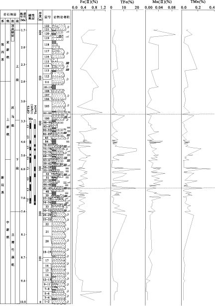
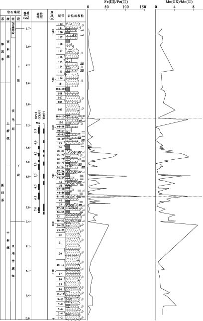
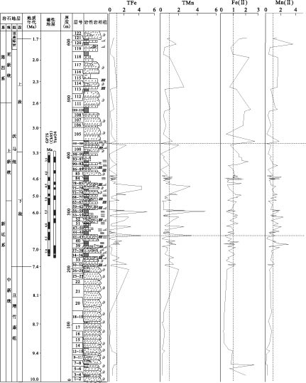
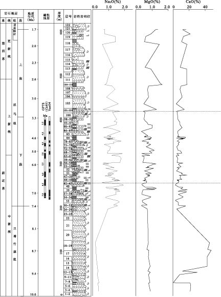
Based on the study of the combining forms of the valence-variable elements such as Fe and Mn at the Oma section in the Gyirong basin, Tibet, and on the relation of the contents of the various forms of the valence-variable elements with climate conditions, the environmental change during the rising of the Qinghai-Tibet plateau is discussed. The distribution rules of the geochemical elements during 10.0-1.7 Ma of the Oma section were ascertained with element geochemistry principles applied and dating data as well as indexes of the conventional and major elements analyzed. The results show that in the sedimentary period of the profile, while the geochemical environment changed from strong reduction state through weak oxidation state to reduction state, the paleoclimate varied from dry-cold through warm-wet to dry-cold accordingly.
Based on the study of the combining forms of the valence-variable elements such as Fe and Mn at the Oma section in the Gyirong basin, Tibet, and on the relation of the contents of the various forms of the valence-variable elements with climate conditions, the environmental change during the rising of the Qinghai-Tibet plateau is discussed. The distribution rules of the geochemical elements during 10.0-1.7 Ma of the Oma section were ascertained with element geochemistry principles applied and dating data as well as indexes of the conventional and major elements analyzed. The results show that in the sedimentary period of the profile, while the geochemical environment changed from strong reduction state through weak oxidation state to reduction state, the paleoclimate varied from dry-cold through warm-wet to dry-cold accordingly.


2010, 35(5): 803-810.
doi: 10.3799/dqkx.2010.093
Abstract:
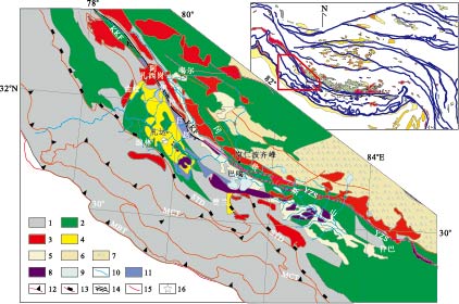
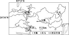
Xunhua basin is one of the inter-mountainous basins distributed in northeastern margin of the Tibetan plateau with over 1 000 m thick lacustrine and fluvial sediments of the Cenozoic. These sediments record both tectonics and climate changes and provide great potential for deciphering how tectonic uplift and climate change interact with each other. However, the absence of high resolution chronology of these sediments has prevented us from understanding their relationship. Accordingly, we performed a detailed magnetostratigraphic study of the Neogene lacustrine and fluvial sediments at the Xigou Section in the Xunhua basin. 560 samples were collected from 280 sites throughout ~560 m thick lacustrine and fluvial sedimentary sequences. A total of 267 samples yielded well defined characteristic remanent magnetization components (ChRMs) by stepwise thermal demagnetization and were used to establish the magnetostratigraphy of the Xigou Section. Based on the vertebrate fossils found at the upper part of the section and characters of the magnetozones, the magnetostratigraphy of the Xigou Section can correlate well with the geomagnetic polarity timescale (CK95), which suggests a depositional age of ~14.6 Ma to ~5.0 Ma. On the basis of the analysis of the sedimentary faceis at the Xigou Section, we are convinced that the Xunhua basin shrinked gradually during ~14.6 to 5.0 Ma. One huge thick conglomerate layer (~20 m thickness) appeared firstly at ~7.3 Ma and was considered to be caused by rapid uplift of the surrounded mountains, which was almost coinstantaneous with rapid uplift of the Tibetan plateau at ~8.0 Ma, implying the synchronous uplift of the Tibetan plateau.
Xunhua basin is one of the inter-mountainous basins distributed in northeastern margin of the Tibetan plateau with over 1 000 m thick lacustrine and fluvial sediments of the Cenozoic. These sediments record both tectonics and climate changes and provide great potential for deciphering how tectonic uplift and climate change interact with each other. However, the absence of high resolution chronology of these sediments has prevented us from understanding their relationship. Accordingly, we performed a detailed magnetostratigraphic study of the Neogene lacustrine and fluvial sediments at the Xigou Section in the Xunhua basin. 560 samples were collected from 280 sites throughout ~560 m thick lacustrine and fluvial sedimentary sequences. A total of 267 samples yielded well defined characteristic remanent magnetization components (ChRMs) by stepwise thermal demagnetization and were used to establish the magnetostratigraphy of the Xigou Section. Based on the vertebrate fossils found at the upper part of the section and characters of the magnetozones, the magnetostratigraphy of the Xigou Section can correlate well with the geomagnetic polarity timescale (CK95), which suggests a depositional age of ~14.6 Ma to ~5.0 Ma. On the basis of the analysis of the sedimentary faceis at the Xigou Section, we are convinced that the Xunhua basin shrinked gradually during ~14.6 to 5.0 Ma. One huge thick conglomerate layer (~20 m thickness) appeared firstly at ~7.3 Ma and was considered to be caused by rapid uplift of the surrounded mountains, which was almost coinstantaneous with rapid uplift of the Tibetan plateau at ~8.0 Ma, implying the synchronous uplift of the Tibetan plateau.


2010, 35(5): 811-820.
doi: 10.3799/dqkx.2010.094
Abstract:
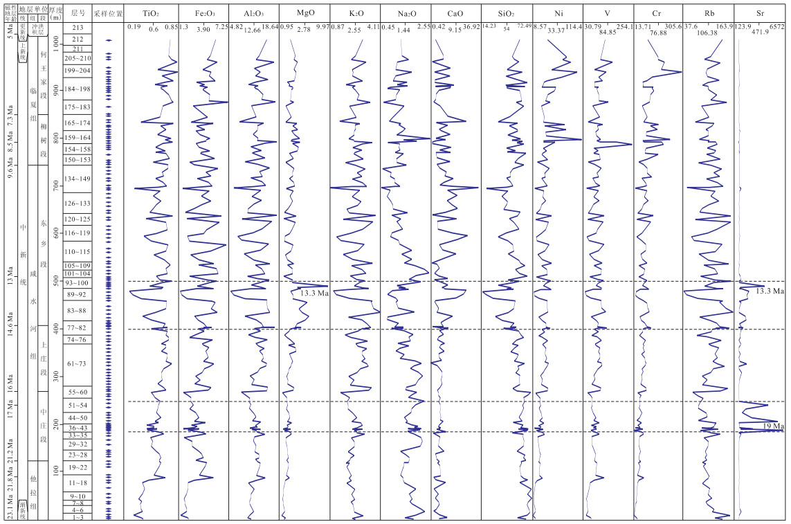
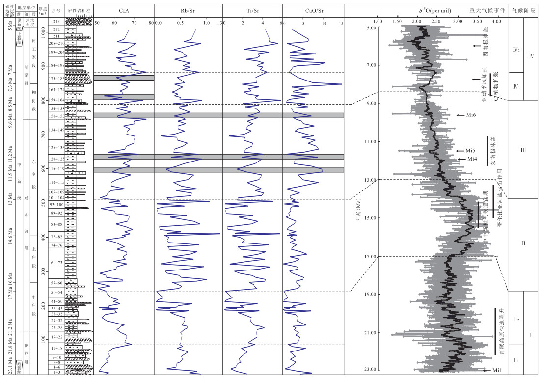
The measured Yangjuangongbai-Xigoushangzhuang Section, Xunhua Section, lies in the southern margin of the Xunhua basin, which is composed of three lithostratigraphic units named Tala Formation, Xianshuihe Formation and Linxia Formation from Oligocene to Pliocene with the thickness of 1 047 m. According to the detail research of the section and sedimentary facies, major and trace elements were analyzed to reveal paleoclimatic information from the deposits during 23.1-5.0 Ma. SiO2, Al2O3, CaO and TFeO (Fe2O3+FeO) are the main chemical components with a sum of 80% at the average level. The element ratios between the deposits and the upper continental crust (UCC) indicate that the paleoclimate of the studied area is characterized as cold and dry during 23.1-5.0 Ma. According to variations of CIA (chemical index of alteration), Rb/Sr, TiO2/Sr and CaO/Sr, the paleoclimate can be divided into four stages. Stage Ⅰ: 23.1-17.0 Ma, it was characterized by cold-dry paleoclimate, including two substages: substage Ⅰ1 (23.1-21.8 Ma) was half-dry and turned warm since Mi1; substage Ⅰ2 (21.8-17.0 Ma) became cold and dry. Stage Ⅱ: 17.0-13.0 Ma, it was warm and wet. Stage Ⅲ: 13.0-8.5 Ma, it was cooler than stage Ⅱ but also wet. Stage Ⅳ: 8.5-5.0 Ma, it changed cold and dry again with two substages: substage Ⅳ1 (8.5-7.0 Ma) was fluctuant changeover and substage Ⅳ2 (7.0-5.0 Ma) became cold and dry. We conclude that both uplift of the Qinghai-Tibet plateau and global climatic changes had effect on the paleoclimatic evolvement during about 23.1-5.0 Ma in the Xunhua basin.
The measured Yangjuangongbai-Xigoushangzhuang Section, Xunhua Section, lies in the southern margin of the Xunhua basin, which is composed of three lithostratigraphic units named Tala Formation, Xianshuihe Formation and Linxia Formation from Oligocene to Pliocene with the thickness of 1 047 m. According to the detail research of the section and sedimentary facies, major and trace elements were analyzed to reveal paleoclimatic information from the deposits during 23.1-5.0 Ma. SiO2, Al2O3, CaO and TFeO (Fe2O3+FeO) are the main chemical components with a sum of 80% at the average level. The element ratios between the deposits and the upper continental crust (UCC) indicate that the paleoclimate of the studied area is characterized as cold and dry during 23.1-5.0 Ma. According to variations of CIA (chemical index of alteration), Rb/Sr, TiO2/Sr and CaO/Sr, the paleoclimate can be divided into four stages. Stage Ⅰ: 23.1-17.0 Ma, it was characterized by cold-dry paleoclimate, including two substages: substage Ⅰ1 (23.1-21.8 Ma) was half-dry and turned warm since Mi1; substage Ⅰ2 (21.8-17.0 Ma) became cold and dry. Stage Ⅱ: 17.0-13.0 Ma, it was warm and wet. Stage Ⅲ: 13.0-8.5 Ma, it was cooler than stage Ⅱ but also wet. Stage Ⅳ: 8.5-5.0 Ma, it changed cold and dry again with two substages: substage Ⅳ1 (8.5-7.0 Ma) was fluctuant changeover and substage Ⅳ2 (7.0-5.0 Ma) became cold and dry. We conclude that both uplift of the Qinghai-Tibet plateau and global climatic changes had effect on the paleoclimatic evolvement during about 23.1-5.0 Ma in the Xunhua basin.


2010, 35(5): 821-827.
doi: 10.3799/dqkx.2010.095
Abstract:
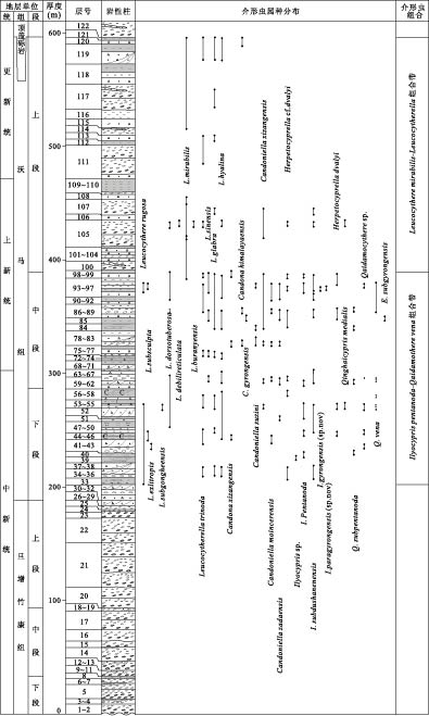
Diverse and abundant ostracoda fossils were found in the Gyirong basin in the south of the Tibet. Our research is based on 37 species of ostracoda including 8 undefined ones that belong to 9 generas. On the basis of the characteristics of ostracoda fossil succession, the ostracoda fauna in this area can be divided into 2 ostracoda assembldges in ascending order as follows: Ilyocypris pentanoda-Qaidamothere vena assembldge and Leucocythere mirabilis-Leucocytherella assembldge. We compared the ostracoda assembldges of Oma Formation with those worldwide at the same stratum and concluded that the age of Oma Formation is Late Miocene to Early Pleistocene.
Diverse and abundant ostracoda fossils were found in the Gyirong basin in the south of the Tibet. Our research is based on 37 species of ostracoda including 8 undefined ones that belong to 9 generas. On the basis of the characteristics of ostracoda fossil succession, the ostracoda fauna in this area can be divided into 2 ostracoda assembldges in ascending order as follows: Ilyocypris pentanoda-Qaidamothere vena assembldge and Leucocythere mirabilis-Leucocytherella assembldge. We compared the ostracoda assembldges of Oma Formation with those worldwide at the same stratum and concluded that the age of Oma Formation is Late Miocene to Early Pleistocene.


2010, 35(5): 828-838.
doi: 10.3799/dqkx.2010.096
Abstract:
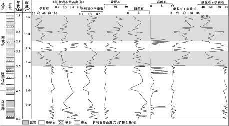
To reconstruct the paleoclimate in the Miocene, clay mineralogy of the Xunhua sediments was investigated using X-ray diffraction (XRD) and scanning electron microscopy (SEM) methods. Our results show that clay minerals of the Miocene sediments are mainly illite and smectite, with minor chlorite, kaolinite, and palygorskite. The apparent changes in their relative contents and illite crystallinity suggest that warm and humid paleoclimate conditions prevailed over the period of 23.1—21.2 Ma, then the mainly cold and dry climate succeeded in the period of 21.2—14.3 Ma, with short intervals of warm and humid climate conditions. The mainly warm and humid climate dominated in the period of 14.3-10.6 Ma, and it changed into a mainly cold and dry climate in the period of 10.6—9.3 Ma. The paleoclimate of the episode of 9.3—5.2 Ma was warm and humid, and it fluctuated frequently between cold/dry and warm/humid. The rapid changes in clay indices in the curves at 21.2 Ma and 5.8 Ma probably suggest the uplift in Xunhua of Qinghai-Tibet plateau.
To reconstruct the paleoclimate in the Miocene, clay mineralogy of the Xunhua sediments was investigated using X-ray diffraction (XRD) and scanning electron microscopy (SEM) methods. Our results show that clay minerals of the Miocene sediments are mainly illite and smectite, with minor chlorite, kaolinite, and palygorskite. The apparent changes in their relative contents and illite crystallinity suggest that warm and humid paleoclimate conditions prevailed over the period of 23.1—21.2 Ma, then the mainly cold and dry climate succeeded in the period of 21.2—14.3 Ma, with short intervals of warm and humid climate conditions. The mainly warm and humid climate dominated in the period of 14.3-10.6 Ma, and it changed into a mainly cold and dry climate in the period of 10.6—9.3 Ma. The paleoclimate of the episode of 9.3—5.2 Ma was warm and humid, and it fluctuated frequently between cold/dry and warm/humid. The rapid changes in clay indices in the curves at 21.2 Ma and 5.8 Ma probably suggest the uplift in Xunhua of Qinghai-Tibet plateau.


2010, 35(5): 839-848.
doi: 10.3799/dqkx.2010.097
Abstract:
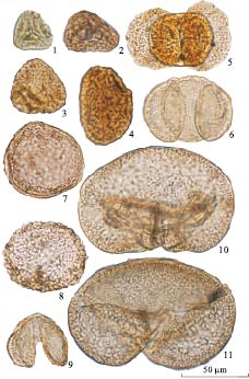
Based on the data of palynology from the Dahonggou Section, Daqaidam area in northeast marginal Qaidam basin. 5 palynological assemblages are recognized as follows: Quercoidites-Ephedripites-Meliaceoidites from the upper Lulehe Formation belongs Early Eocene; Quercoidites-Piceaepollenites-Meliaceoidites from the bottom of Lower Ganchaigou Formation belongs to Middle Eocene; Ephedripites-Qinghaipollis-Nitrariadites from the middle of Lower Ganchaigou Formation belongs to Later Eocene-Early Oligocene; Ephedripites-Chenopodipollis-Nitrariadites from the bottom of Upper Ganchaigou Formation belongs to Middle Oligocene; Betulaepollenites-Ephedripites-Pinus from the top of Upper Ganchaigou Formation belongs to Late Oligocene. Palynological assemblage from the Tarim basin, Qaidam basin and Xining-Minhe basin can be well compared.
Based on the data of palynology from the Dahonggou Section, Daqaidam area in northeast marginal Qaidam basin. 5 palynological assemblages are recognized as follows: Quercoidites-Ephedripites-Meliaceoidites from the upper Lulehe Formation belongs Early Eocene; Quercoidites-Piceaepollenites-Meliaceoidites from the bottom of Lower Ganchaigou Formation belongs to Middle Eocene; Ephedripites-Qinghaipollis-Nitrariadites from the middle of Lower Ganchaigou Formation belongs to Later Eocene-Early Oligocene; Ephedripites-Chenopodipollis-Nitrariadites from the bottom of Upper Ganchaigou Formation belongs to Middle Oligocene; Betulaepollenites-Ephedripites-Pinus from the top of Upper Ganchaigou Formation belongs to Late Oligocene. Palynological assemblage from the Tarim basin, Qaidam basin and Xining-Minhe basin can be well compared.


2010, 35(5): 849-856.
doi: 10.3799/dqkx.2010.098
Abstract:
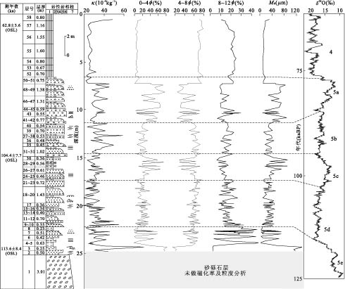
Sedimentological analyses of the third terrace along the banks of the Yellow River in Xunhua basin have yielded results that have more than regional significance. They are concerned with the reaction of rivers to climatic changes in the Pleistocene. Based on the field investigations, granularity, magnetic susceptibility, palynological records and optically stimulated luminescence (OSL) dating, the age of the third terrace was revealed. It shows that the Yellow River incised during the transition from interglacial to glacial. Evidences show that the paleoclimate and environment in Xunhua basin during the Late Pleistocene can be roughly divided into six stages: (1) 120—114 ka, the climate was warm and moist; (2) 114—105 ka, the climate turned cool and dry; (3) 105—98 ka, the climate was relatively warm and humid; (4) 98-85 ka, the climate turned cool and temperature; (5) 85—75 ka, the climate was warm and humid; (6) 75—63 ka, the climate was cold and dry, which can be compared with high-resolution ice core and marine oxygen isotope climate series.
Sedimentological analyses of the third terrace along the banks of the Yellow River in Xunhua basin have yielded results that have more than regional significance. They are concerned with the reaction of rivers to climatic changes in the Pleistocene. Based on the field investigations, granularity, magnetic susceptibility, palynological records and optically stimulated luminescence (OSL) dating, the age of the third terrace was revealed. It shows that the Yellow River incised during the transition from interglacial to glacial. Evidences show that the paleoclimate and environment in Xunhua basin during the Late Pleistocene can be roughly divided into six stages: (1) 120—114 ka, the climate was warm and moist; (2) 114—105 ka, the climate turned cool and dry; (3) 105—98 ka, the climate was relatively warm and humid; (4) 98-85 ka, the climate turned cool and temperature; (5) 85—75 ka, the climate was warm and humid; (6) 75—63 ka, the climate was cold and dry, which can be compared with high-resolution ice core and marine oxygen isotope climate series.


2010, 35(5): 857-866.
doi: 10.3799/dqkx.2010.099
Abstract:
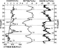
The later phase of marine isotope stage 3 (i.e. MIS3a) on Qinghai-Tibet plateau was characterized by its special warm-humid climate. The constructed AMS14C calendar age-depth model, the component of n-alkanes, together with the grain size and total organic carbon (TOC) of lacustrine sediments in Dujiangyan S1 Section are used to elucidate the paleoclimate changes. The results indicate that rapid fluctuation on millennial scale was the main characteristic in the eastern margin of Qinghai-Tibet plateau during 43.6—34.6 kaBP. The Dansgaard-Oeschger events 11—7 can be reflected by these proxies, especially TOC. Comparison between TOC curve and oxygen isotope record from Hulu Cave and Greenland GRIP indicates that paleoclimate records in Dujiangyan respond to ice volume change in the high-latitude area and Asia monsoon oscillation. But the difference was shown because the influence of insolation values precession was strong in this area.
The later phase of marine isotope stage 3 (i.e. MIS3a) on Qinghai-Tibet plateau was characterized by its special warm-humid climate. The constructed AMS14C calendar age-depth model, the component of n-alkanes, together with the grain size and total organic carbon (TOC) of lacustrine sediments in Dujiangyan S1 Section are used to elucidate the paleoclimate changes. The results indicate that rapid fluctuation on millennial scale was the main characteristic in the eastern margin of Qinghai-Tibet plateau during 43.6—34.6 kaBP. The Dansgaard-Oeschger events 11—7 can be reflected by these proxies, especially TOC. Comparison between TOC curve and oxygen isotope record from Hulu Cave and Greenland GRIP indicates that paleoclimate records in Dujiangyan respond to ice volume change in the high-latitude area and Asia monsoon oscillation. But the difference was shown because the influence of insolation values precession was strong in this area.


2010, 35(5): 867-872.
doi: 10.3799/dqkx.2010.100
Abstract:
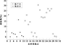
This paper focuses on the aquatic environmental conditions responsible for kashin-beck disease (KBD) within the Ruo'ergai County of Sichuan Province. A total of 38 groundwater and surface water samples were collected during September 2008. The water quality data sets in this research include major cations, anions, and trace elements. The results indicate that the drinking water in the KBD area has relatively low contents in both the major and trace elements and people drinking the surface water there are more likely to become KBD victims. Combined with the hydrological and hydrochemical evidence, it reveals that the KBD mainly results from the abnormal contents of multiple constituents in the drinking water. The multivariate analytical method factor analysis (FA) results further indicate that the KBD prevalence in the study area has close relationship with P, F, Se, Mn contents in drinking water and the lower the P, F, Se, and Mn contents are, the more the KBD cases are invloved.
This paper focuses on the aquatic environmental conditions responsible for kashin-beck disease (KBD) within the Ruo'ergai County of Sichuan Province. A total of 38 groundwater and surface water samples were collected during September 2008. The water quality data sets in this research include major cations, anions, and trace elements. The results indicate that the drinking water in the KBD area has relatively low contents in both the major and trace elements and people drinking the surface water there are more likely to become KBD victims. Combined with the hydrological and hydrochemical evidence, it reveals that the KBD mainly results from the abnormal contents of multiple constituents in the drinking water. The multivariate analytical method factor analysis (FA) results further indicate that the KBD prevalence in the study area has close relationship with P, F, Se, Mn contents in drinking water and the lower the P, F, Se, and Mn contents are, the more the KBD cases are invloved.

2010, 35(5): 873-878.
doi: 10.3799/dqkx.2010.101
Abstract:
The variation characteristics of oxygen and hydrogen isotopes in surface runoff of the Lhasa River basin was studied based on the observations of δ18O and δD in river water and related meteorological and hydrological data in 2008. The results indicate that: (1) precipitation is the main recharge source and that the Lhasa River has experienced strong evaporation; (2) positive d values indicate the snow melting water recharge; (3) during the Tibetan plateau summer monsoon period, the lapse rate of δ18O in river water is approximately 0.16‰·(100 m)-1 due to the "altitude effect"; (4) in large-scale circulation, the basin water presents a significant continental effect. This study demonstrates that it is possible to trace the hydrological cycle with oxygen isotope and deuterium distribution in land runoff in the high altitude areas and to provide the stable isotopic evidence of the ancient latitude variation.
The variation characteristics of oxygen and hydrogen isotopes in surface runoff of the Lhasa River basin was studied based on the observations of δ18O and δD in river water and related meteorological and hydrological data in 2008. The results indicate that: (1) precipitation is the main recharge source and that the Lhasa River has experienced strong evaporation; (2) positive d values indicate the snow melting water recharge; (3) during the Tibetan plateau summer monsoon period, the lapse rate of δ18O in river water is approximately 0.16‰·(100 m)-1 due to the "altitude effect"; (4) in large-scale circulation, the basin water presents a significant continental effect. This study demonstrates that it is possible to trace the hydrological cycle with oxygen isotope and deuterium distribution in land runoff in the high altitude areas and to provide the stable isotopic evidence of the ancient latitude variation.


2010, 35(5): 879-884.
doi: 10.3799/dqkx.2010.102
Abstract:
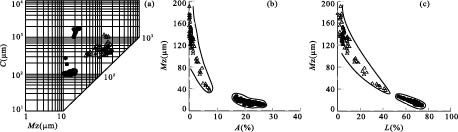
Based on the grain size analyses of "Wushan Loess" at Wushan area, the causes of "Wushan Loess" are discussed in this paper. The results show as follows. The component particles of the "Wushan Loess" are predominantly less than 50 μm with the average content of > 50 μm about 16.9%; the average content of coarse silt (10-50 μm) is 43.1% as the "dominant group" of the "Wushan Loess"; the average content of 5-10 μm group is 14.5% and < 5 μm group makes up 25.5%. The characteristics of grain size parameters and frequency and probability cumulative distribution curves are the same as those of typical atmospheric dust sediment, which shows that the "Wushan Loess" is of aeolian origin. C-M, L-M, A-M chart and statistical indices of grain size distribution are obviously different from those of fluvial sediment and are the same as those of Xiashu Loess distributed in the middle and lower reaches of the Yangtze River. The most discriminant analysis result is of negative value, which displays that the aeolian origin is prevailing and individual layer is affected by water flow action.
Based on the grain size analyses of "Wushan Loess" at Wushan area, the causes of "Wushan Loess" are discussed in this paper. The results show as follows. The component particles of the "Wushan Loess" are predominantly less than 50 μm with the average content of > 50 μm about 16.9%; the average content of coarse silt (10-50 μm) is 43.1% as the "dominant group" of the "Wushan Loess"; the average content of 5-10 μm group is 14.5% and < 5 μm group makes up 25.5%. The characteristics of grain size parameters and frequency and probability cumulative distribution curves are the same as those of typical atmospheric dust sediment, which shows that the "Wushan Loess" is of aeolian origin. C-M, L-M, A-M chart and statistical indices of grain size distribution are obviously different from those of fluvial sediment and are the same as those of Xiashu Loess distributed in the middle and lower reaches of the Yangtze River. The most discriminant analysis result is of negative value, which displays that the aeolian origin is prevailing and individual layer is affected by water flow action.


2010, 35(5): 885-890.
doi: 10.3799/dqkx.2010.103
Abstract:
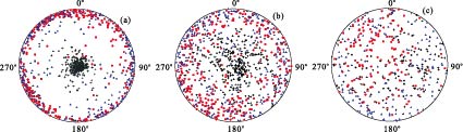
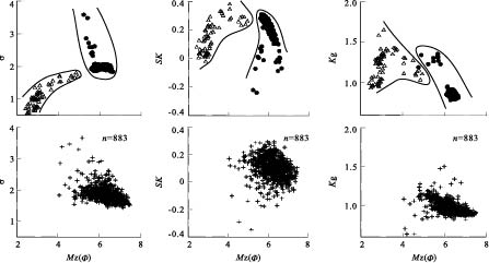
In this paper we present the magnetic fabric and magnetic susceptibility characters of one newly found "Wushan Loess" Section, which was also compared with the modern Yangtze River sediments and aeolian loess and "Sand-Dune" sediments distributed at the Middle Yangtze River. The results are as follows. (1) The κ, P, F, L, E values of the "Wushan Loess" are close to those of the aeolian loess and "Sand-Dune" sediments, however these values are obviously lower than those of the modern Yangtze River sediments. (2) Shown on the F-L graph, data of the "Wushan Loess" converge upon the origin of coordinates, similar to the aeolian loess and "Sand-Dune" sediments distributed at the Middle Yangtze River, which reveals sedimentary environment with relatively lower power. Data of the modern Yangtze River sediments lies around the F-axis, showing more dominance of F rather than L. (3) Maximum magnetic principal axis of the "Wushan Loess" is similar to that of the aeolian loess and "Sand-Dune" sediments distributed at the Middle Yangtze River, with the direction of declination relatively dispersing and the inclination of long axis varying between 36° and 38° and the inclination of the short axis varying between 37° and 39°. However the direction of maximum magnetic principal axis declination of the modern Yangtze River is relatively stable with inclination of the long axis smaller than 10° and short axis bigger than 80°. (4) T values of the "Wushan Loess" vary between -1 and 1 while T values of the modern Yangtze River are mainly higher than 1. Generally, magnetic fabric characters are similar to aeolian loess and "Sand-Dune" sediments distributed at the Middle Yangtze River, revealing its aeolian origin.
In this paper we present the magnetic fabric and magnetic susceptibility characters of one newly found "Wushan Loess" Section, which was also compared with the modern Yangtze River sediments and aeolian loess and "Sand-Dune" sediments distributed at the Middle Yangtze River. The results are as follows. (1) The κ, P, F, L, E values of the "Wushan Loess" are close to those of the aeolian loess and "Sand-Dune" sediments, however these values are obviously lower than those of the modern Yangtze River sediments. (2) Shown on the F-L graph, data of the "Wushan Loess" converge upon the origin of coordinates, similar to the aeolian loess and "Sand-Dune" sediments distributed at the Middle Yangtze River, which reveals sedimentary environment with relatively lower power. Data of the modern Yangtze River sediments lies around the F-axis, showing more dominance of F rather than L. (3) Maximum magnetic principal axis of the "Wushan Loess" is similar to that of the aeolian loess and "Sand-Dune" sediments distributed at the Middle Yangtze River, with the direction of declination relatively dispersing and the inclination of long axis varying between 36° and 38° and the inclination of the short axis varying between 37° and 39°. However the direction of maximum magnetic principal axis declination of the modern Yangtze River is relatively stable with inclination of the long axis smaller than 10° and short axis bigger than 80°. (4) T values of the "Wushan Loess" vary between -1 and 1 while T values of the modern Yangtze River are mainly higher than 1. Generally, magnetic fabric characters are similar to aeolian loess and "Sand-Dune" sediments distributed at the Middle Yangtze River, revealing its aeolian origin.