


2010 Vol. 35, No. 6
Display Method:
2010, 35(6): 891-898.
doi: 10.3799/dqkx.2010.104
 PDF 1679KB
Abstract:
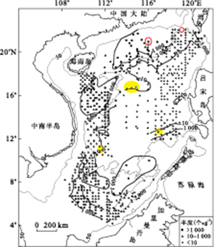
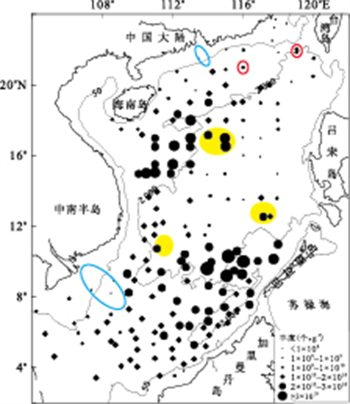
This paper determines the calcium carbonate content in 213 surface sediment samples from the South China Sea (SCS) in order to have a comprehensive analysis of the distribution character of calcium carbonate and its controlling factors in surface sediments of the SCS. The results show that there are different influence parameters in distributions of calcium carbonate in various regions: In the shelf, calcium carbonate contents are low owing to largely terrigenous material input; In the slope, calcium carbonate contents are high due to abundant supply of calcareous organisms, low terrigenous material input and weak dissolvability; In the deep basin, calcium carbonate contents are very low because of strong dissolvability. According to the distribution character of calcium carbonate content in surface sediments in the SCS, it is concluded that the carbonate compensation depths (CCD) are about 3700m in the north of 14°N and about 4000m in the south of 14°N. Pearson Correlation shows that calcareous nannofossils had significant contribution to the calcium carbonate content in surface sediments in the SCS.
This paper determines the calcium carbonate content in 213 surface sediment samples from the South China Sea (SCS) in order to have a comprehensive analysis of the distribution character of calcium carbonate and its controlling factors in surface sediments of the SCS. The results show that there are different influence parameters in distributions of calcium carbonate in various regions: In the shelf, calcium carbonate contents are low owing to largely terrigenous material input; In the slope, calcium carbonate contents are high due to abundant supply of calcareous organisms, low terrigenous material input and weak dissolvability; In the deep basin, calcium carbonate contents are very low because of strong dissolvability. According to the distribution character of calcium carbonate content in surface sediments in the SCS, it is concluded that the carbonate compensation depths (CCD) are about 3700m in the north of 14°N and about 4000m in the south of 14°N. Pearson Correlation shows that calcareous nannofossils had significant contribution to the calcium carbonate content in surface sediments in the SCS.


2010, 35(6): 899-907.
doi: 10.3799/dqkx.2010.105
Abstract:
Dripping water was seasonally collected from several sites (denoted as site 1D, 3D, 4D and 5D toward the cave entrance respectively) inside the oligotrophic Heshang cave, Central China, to detect the metabolic activities of microbial communities in response to rainfall and temperature. Viable counting method, the DAPI staining technique as well as Biolog Eco microplates were exploited for microbial counting and metabolic changes of microbial communities. Results confirm the existence of microbes in the dripping water though the microbial biomass is as low as that in the deep sea water column. The metabolic activities of microbial communities varied with sites as indicated by the average well color development (AWCD) values in Biolog ECO microplates. Microbes in site 1D showed the strongest metabolic activities followed by those in site 3D. Microbial communities in the sites near the cave entrance, such as site 4D and site 5D, however, displayed the weakest metabolic activities as shown by the invariant AWCD values after 24-hour incubation. Similar microbial diversity indices were observed between different sites such as site 1D and site 3D, and even among different seasons. This indicates the presence of a fairly stable microbial diversity in the dripping water, probably due to the oligotrophic condition in the cave. However, the carbon utilization pattern of microbial communities in site 1D differed greatly among seasons; the pattern in Sept. 2008 is distinguishable from those in other sampling periods. The seasonal variation in carbon utilization might arises from the seasonal changes of dissolved organic matter or the changes in the flow rate of dripping water. Noticeably, such kind of seasonal variation in the carbon utilization was not reproduced in site 3D. Yet we need further investigations to determine the relationship between the changes in microbial community and the climate factors such as temperature and rainfall.
Dripping water was seasonally collected from several sites (denoted as site 1D, 3D, 4D and 5D toward the cave entrance respectively) inside the oligotrophic Heshang cave, Central China, to detect the metabolic activities of microbial communities in response to rainfall and temperature. Viable counting method, the DAPI staining technique as well as Biolog Eco microplates were exploited for microbial counting and metabolic changes of microbial communities. Results confirm the existence of microbes in the dripping water though the microbial biomass is as low as that in the deep sea water column. The metabolic activities of microbial communities varied with sites as indicated by the average well color development (AWCD) values in Biolog ECO microplates. Microbes in site 1D showed the strongest metabolic activities followed by those in site 3D. Microbial communities in the sites near the cave entrance, such as site 4D and site 5D, however, displayed the weakest metabolic activities as shown by the invariant AWCD values after 24-hour incubation. Similar microbial diversity indices were observed between different sites such as site 1D and site 3D, and even among different seasons. This indicates the presence of a fairly stable microbial diversity in the dripping water, probably due to the oligotrophic condition in the cave. However, the carbon utilization pattern of microbial communities in site 1D differed greatly among seasons; the pattern in Sept. 2008 is distinguishable from those in other sampling periods. The seasonal variation in carbon utilization might arises from the seasonal changes of dissolved organic matter or the changes in the flow rate of dripping water. Noticeably, such kind of seasonal variation in the carbon utilization was not reproduced in site 3D. Yet we need further investigations to determine the relationship between the changes in microbial community and the climate factors such as temperature and rainfall.


2010, 35(6): 908-920.
doi: 10.3799/dqkx.2010.106
Abstract:
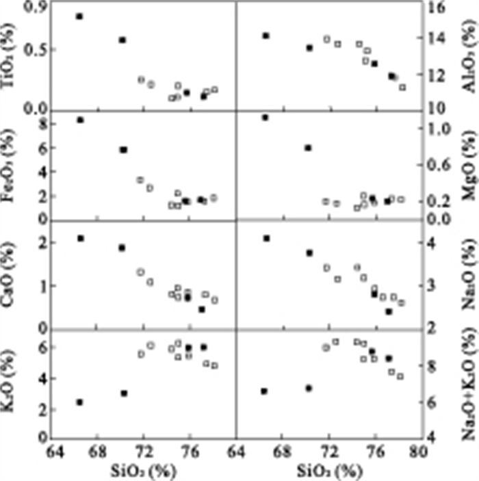
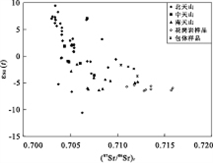
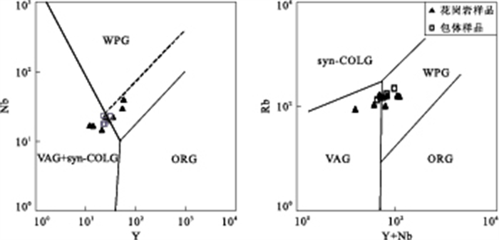
The Late Permian Yingmailai granitic intrusion is located in the middle part of the southern Tianshan. It consists predominantly of biotite K-feldspar granite with minor two-mica K-feldspar granite. Two types of ellipse-shaped xenoliths including dark-color fine-granular xenolith and light-color granitic xenolith have been recognized in the granitic intrusion. The xenoliths share geochemical similarities with granites. They are characterized by high SiO2 contents, enrichment of K and total alkali coupled with low MgO and CaO contents. Furthermore, they display the enrichment in Rb, Ba, Th and REE as well as significant fractionation of LREE from HREE, and negative Nb, Ta, Zr and Hf anomalies on the ORG normalized trace element patterns. The similar variation trends of major oxides between granites and xenoliths on the Harker diagram suggest that they derived from a common parental magma. The A/CNK ratios range from 0.99 to 1.08, meta-aluminous to per-aluminous feature. The chondrite-normalized REE patterns are characterized by strong enrichment of LREE relative to HREE and significantly negative Eu anomalies. In combination with their high (87Sr/86Sr)t ratios (0.71036 to 0.71585) and negative εNd(t) values (-1.67 to -6.45), it can be inferred that the magmas might have been produced by dehydration melting of crust-source amphibole-bearing mafic rocks (< 50km), and that crystal fractionation of biotite and plagioclase with minor magnetite might have occurred before emplacement. The petrological and geochemical characteristics of the granitic rocks suggest that the intrusion is a transition type between A and S types, and formed in the late or end stage of collision between Tarim and Kazakhstan plate in Late Permian time.
The Late Permian Yingmailai granitic intrusion is located in the middle part of the southern Tianshan. It consists predominantly of biotite K-feldspar granite with minor two-mica K-feldspar granite. Two types of ellipse-shaped xenoliths including dark-color fine-granular xenolith and light-color granitic xenolith have been recognized in the granitic intrusion. The xenoliths share geochemical similarities with granites. They are characterized by high SiO2 contents, enrichment of K and total alkali coupled with low MgO and CaO contents. Furthermore, they display the enrichment in Rb, Ba, Th and REE as well as significant fractionation of LREE from HREE, and negative Nb, Ta, Zr and Hf anomalies on the ORG normalized trace element patterns. The similar variation trends of major oxides between granites and xenoliths on the Harker diagram suggest that they derived from a common parental magma. The A/CNK ratios range from 0.99 to 1.08, meta-aluminous to per-aluminous feature. The chondrite-normalized REE patterns are characterized by strong enrichment of LREE relative to HREE and significantly negative Eu anomalies. In combination with their high (87Sr/86Sr)t ratios (0.71036 to 0.71585) and negative εNd(t) values (-1.67 to -6.45), it can be inferred that the magmas might have been produced by dehydration melting of crust-source amphibole-bearing mafic rocks (< 50km), and that crystal fractionation of biotite and plagioclase with minor magnetite might have occurred before emplacement. The petrological and geochemical characteristics of the granitic rocks suggest that the intrusion is a transition type between A and S types, and formed in the late or end stage of collision between Tarim and Kazakhstan plate in Late Permian time.


2010, 35(6): 921-932.
doi: 10.3799/dqkx.2010.107
Abstract:
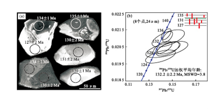
A large scale of intermediate dykes developed in Xar Moron fault belt in Linxi county, Inner-Mongolia, with NE3° to 5° angle of strike and nearly vertical trend. LA-ICP-MS zircon U-Pb dating method and whole rock geochemistry test were applied. It is indicated that the intermediate dykes emplaced in Lower Cretaceous with LA-ICP-MS zircon U-Pb age of 132.2±2.2Ma. The whole rock geochemistry of the dykes reveals transition characteristics between high potassium calc-alkaline series and shoshonite series. They formed in intraplate extensional background and sourced from crust-mantle magmatic mixing, which result from the mantle magma underplating below the early subducted oceanic crust. The strike of the dykes was chronically controlled by a sinistral shear mechanism in the area, which might be related to the northward movement of Pacific plate to Asian plate.
A large scale of intermediate dykes developed in Xar Moron fault belt in Linxi county, Inner-Mongolia, with NE3° to 5° angle of strike and nearly vertical trend. LA-ICP-MS zircon U-Pb dating method and whole rock geochemistry test were applied. It is indicated that the intermediate dykes emplaced in Lower Cretaceous with LA-ICP-MS zircon U-Pb age of 132.2±2.2Ma. The whole rock geochemistry of the dykes reveals transition characteristics between high potassium calc-alkaline series and shoshonite series. They formed in intraplate extensional background and sourced from crust-mantle magmatic mixing, which result from the mantle magma underplating below the early subducted oceanic crust. The strike of the dykes was chronically controlled by a sinistral shear mechanism in the area, which might be related to the northward movement of Pacific plate to Asian plate.


2010, 35(6): 933-946.
doi: 10.3799/dqkx.2010.108
Abstract:
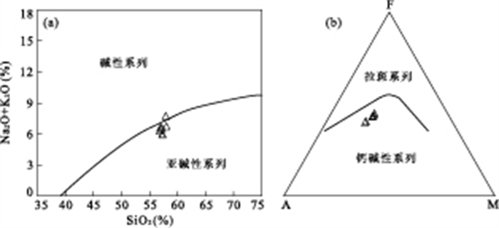
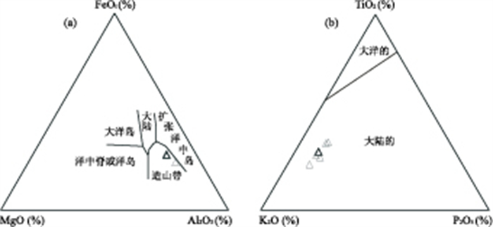
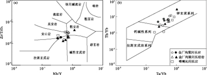
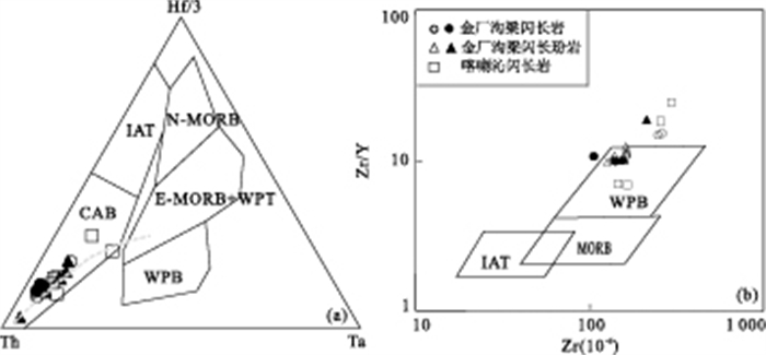
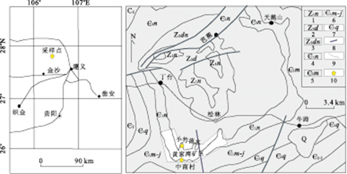
Jinchanggouliang region, which consists of Jinchanggouliang, Erdaogou and Xiaoerdaogou gold deposits, is located in the north of North China Craton (NCC) and south of Inner Mongolia-Daxinganling orogenic belt. Numerous early Mesozoic diorites and diorite porphyries occurred and yielded LA-ICP-MS zircon U-Pb age of 228±1 Ma (MSWD=0.26) in the region. Both diorites and diorite porphyries are dominated by shoshonitic rocks, which contain SiO2 ranging from 51.22% to 68.48% and MgO from 1.35% to 8.13%, and are characterized by high contents of Na2O+K2O and Al2O3 but low concentrations of P2O5. These rocks are enriched in LREE, LILE but depleted in HFSE. All samples possess uniform (87Sr/86Sr)i isotopic ratios (0.704 95-0.705 92) but relatively wider range of εNd(t) (-0.2 to -9.5) and T2DM ages (1.02-1.77 Ga). These results indicate that the magma source derived from mixing of lithospheric mantle and lower crust melt. Diagrams of major and trace elements reveal that dykes formed in transitional environment between land arc and intra-plate. Combined with some new discoveries in the neighborhood, such as dyke swarms, alkaline intrusive complex and A2-type granite, this study proposes that NCB had completed the collision with Siberia plate in Late Triassic and the north of NCC went into a post-orogenic extension stage.
Jinchanggouliang region, which consists of Jinchanggouliang, Erdaogou and Xiaoerdaogou gold deposits, is located in the north of North China Craton (NCC) and south of Inner Mongolia-Daxinganling orogenic belt. Numerous early Mesozoic diorites and diorite porphyries occurred and yielded LA-ICP-MS zircon U-Pb age of 228±1 Ma (MSWD=0.26) in the region. Both diorites and diorite porphyries are dominated by shoshonitic rocks, which contain SiO2 ranging from 51.22% to 68.48% and MgO from 1.35% to 8.13%, and are characterized by high contents of Na2O+K2O and Al2O3 but low concentrations of P2O5. These rocks are enriched in LREE, LILE but depleted in HFSE. All samples possess uniform (87Sr/86Sr)i isotopic ratios (0.704 95-0.705 92) but relatively wider range of εNd(t) (-0.2 to -9.5) and T2DM ages (1.02-1.77 Ga). These results indicate that the magma source derived from mixing of lithospheric mantle and lower crust melt. Diagrams of major and trace elements reveal that dykes formed in transitional environment between land arc and intra-plate. Combined with some new discoveries in the neighborhood, such as dyke swarms, alkaline intrusive complex and A2-type granite, this study proposes that NCB had completed the collision with Siberia plate in Late Triassic and the north of NCC went into a post-orogenic extension stage.


2010, 35(6): 947-958.
doi: 10.3799/dqkx.2010.109
Abstract:
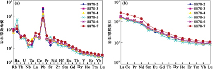
Herein, XRF, ICP-MS and hydride generation atomic fluorescence spectrometry (HGAFS) techniques were used to analyze the major, trace elements and Se contents of the Se-rich black rock series in Zunyi, Guizhou Province, respectively. Based on the elemental geochemistry, we suggest that the Se-rich black rock series, including K-bentonite, phosphrite, black shales, cherts and Ni-Mo ore samples, mainly formed by hydrothermal deposition. Meanwhile, the petrogenesis of the black rock series was related with volcanism. Furthermore, K-bentonite, phosphrite, black shales, chert and Ni-Mo ore samples are characterized by high Se contents, and high enrichment coefficients correspond to those of the crust (801, 531.2, 449, 123 and 11 133). Combining with previous studies, we propose that the enrichment of Se in study area is related to many factors, such as existence of abundant sulfide, hydrothermal deposition and volcanism.
Herein, XRF, ICP-MS and hydride generation atomic fluorescence spectrometry (HGAFS) techniques were used to analyze the major, trace elements and Se contents of the Se-rich black rock series in Zunyi, Guizhou Province, respectively. Based on the elemental geochemistry, we suggest that the Se-rich black rock series, including K-bentonite, phosphrite, black shales, cherts and Ni-Mo ore samples, mainly formed by hydrothermal deposition. Meanwhile, the petrogenesis of the black rock series was related with volcanism. Furthermore, K-bentonite, phosphrite, black shales, chert and Ni-Mo ore samples are characterized by high Se contents, and high enrichment coefficients correspond to those of the crust (801, 531.2, 449, 123 and 11 133). Combining with previous studies, we propose that the enrichment of Se in study area is related to many factors, such as existence of abundant sulfide, hydrothermal deposition and volcanism.


2010, 35(6): 959-968.
doi: 10.3799/dqkx.2010.110
Abstract:
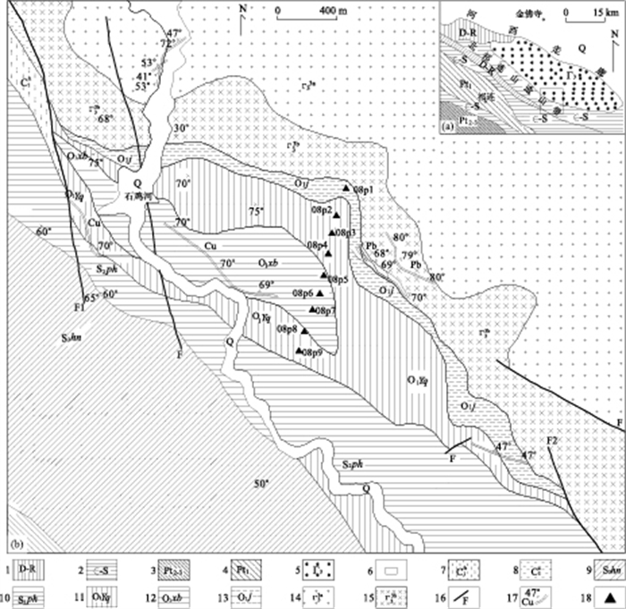
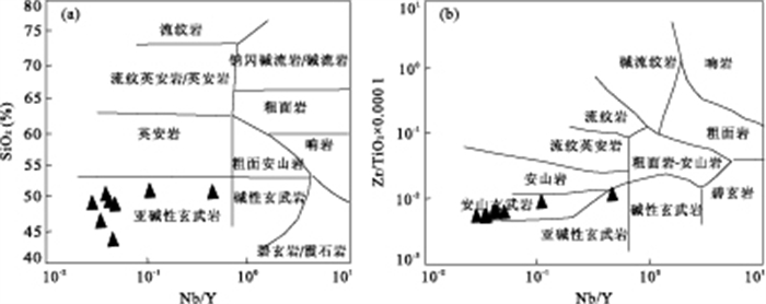
Recent studies showed that the Shijihe area is an important polymetallic metallogenic belt in western part of North Qilian Mountains in China. However, geological study degree is very low due to its remoteness and poor conditions. The Lavas of Shijihe area consists of actinolitite hornstone and spilite. The geochemical characteristics of metamorphic basic lava with flat REE distribution patterns, the contents of HFSE similar to N-MORB and εNd(0)=+9.03~+9.42 (except the sample 08p1) manifest that the rocks belong to the tholeiitic basalt series. Sr isotope characteristics indicate that Sr isotopic composition of the rocks was altered because of the metamorphism of the rock instead of the interfused crust. Sm-Nd isochron age is 481±20 Ma. The metamorphic basic lavas of Shijihe area is residue of Early Ordovician. The diagenesis environment is oceanic ridge instead of continental collision with closing of ocean basin.
Recent studies showed that the Shijihe area is an important polymetallic metallogenic belt in western part of North Qilian Mountains in China. However, geological study degree is very low due to its remoteness and poor conditions. The Lavas of Shijihe area consists of actinolitite hornstone and spilite. The geochemical characteristics of metamorphic basic lava with flat REE distribution patterns, the contents of HFSE similar to N-MORB and εNd(0)=+9.03~+9.42 (except the sample 08p1) manifest that the rocks belong to the tholeiitic basalt series. Sr isotope characteristics indicate that Sr isotopic composition of the rocks was altered because of the metamorphism of the rock instead of the interfused crust. Sm-Nd isochron age is 481±20 Ma. The metamorphic basic lavas of Shijihe area is residue of Early Ordovician. The diagenesis environment is oceanic ridge instead of continental collision with closing of ocean basin.


2010, 35(6): 969-984.
doi: 10.3799/dqkx.2010.111
Abstract:
Taoxi uplift is a part of Wuyishan uplift and occurs as metamorphic core complexes. There are abundant medium to large scale copper and polymetallic ore deposits distributed in the uplift, such as the super large scale Zijinshan copper-gold deposit, super large Yanbei tin deposit, and large scale Hongshan copper deposit. This area is representative of a rich segment of Wuyi metallogenic belt. The main geochronology dating of mineralization concentrates in the range of 130-90 Ma, the late Yanshan period. The ore deposits, as well as most copper-gold ore deposits located in Taoxi uplift are of porphyry-magmatic hydrothermal type. Geochronology dating of ore bearing porphyry stocks is 94-140 Ma, the middle to late period derivatives of Yanshan magmatic complex resulted from interaction of crust with mantle and the lithosphere delamination in the Late Mesozoic. Taoxi Uplift is characterized by lithosphere thickening and delamination, intrusion of the asthenosphere matter and magmatism, and accompanied mineralization.
Taoxi uplift is a part of Wuyishan uplift and occurs as metamorphic core complexes. There are abundant medium to large scale copper and polymetallic ore deposits distributed in the uplift, such as the super large scale Zijinshan copper-gold deposit, super large Yanbei tin deposit, and large scale Hongshan copper deposit. This area is representative of a rich segment of Wuyi metallogenic belt. The main geochronology dating of mineralization concentrates in the range of 130-90 Ma, the late Yanshan period. The ore deposits, as well as most copper-gold ore deposits located in Taoxi uplift are of porphyry-magmatic hydrothermal type. Geochronology dating of ore bearing porphyry stocks is 94-140 Ma, the middle to late period derivatives of Yanshan magmatic complex resulted from interaction of crust with mantle and the lithosphere delamination in the Late Mesozoic. Taoxi Uplift is characterized by lithosphere thickening and delamination, intrusion of the asthenosphere matter and magmatism, and accompanied mineralization.


2010, 35(6): 985-999.
doi: 10.3799/dqkx.2010.112
Abstract:
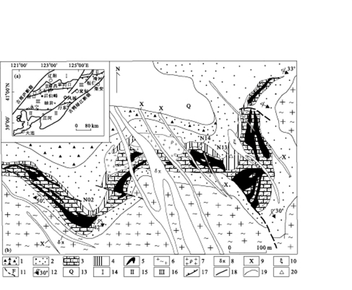
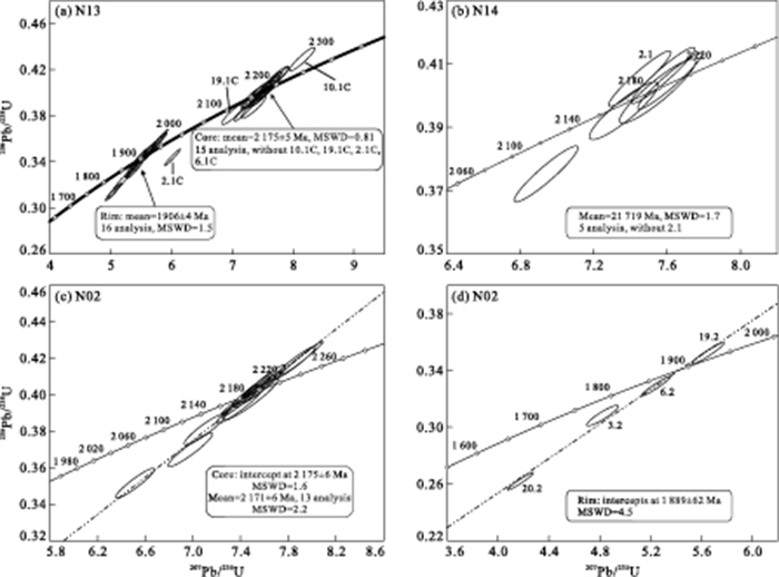
SHRIMP zircon U-Pb dating results are firstly reported for the hyalotourmalites in Houxianyu borate deposit in order to determine its formation time. The zircons commonly have core-rim structures. Most cores show oscillatory zoning in CL and plane polarized light images, suggesting a magmatic detrital origin. The zircon without distinct structural change may represent a metamorphic origin. Magmatic detrital zircons and metamorphic zircons from three samples yield ages of 2 171-2 175 Ma and 1 894-1 906 Ma, respectively. Combined with geology and lithology, the protolith of hyalotourmalite is concluded to be the product of exhalation of submarine hot water caused by the magmatic activity with the magma derived from the depleted mantle source with crustal contamination in the cratonic rift environment, which occurred in the middle Palaeoproterozoic (2 171-2 175 Ma) and underwent the late metamorphism during a period of 1 894-1 906 Ma.
SHRIMP zircon U-Pb dating results are firstly reported for the hyalotourmalites in Houxianyu borate deposit in order to determine its formation time. The zircons commonly have core-rim structures. Most cores show oscillatory zoning in CL and plane polarized light images, suggesting a magmatic detrital origin. The zircon without distinct structural change may represent a metamorphic origin. Magmatic detrital zircons and metamorphic zircons from three samples yield ages of 2 171-2 175 Ma and 1 894-1 906 Ma, respectively. Combined with geology and lithology, the protolith of hyalotourmalite is concluded to be the product of exhalation of submarine hot water caused by the magmatic activity with the magma derived from the depleted mantle source with crustal contamination in the cratonic rift environment, which occurred in the middle Palaeoproterozoic (2 171-2 175 Ma) and underwent the late metamorphism during a period of 1 894-1 906 Ma.


2010, 35(6): 1000-1010.
doi: 10.3799/dqkx.2010.113
Abstract:
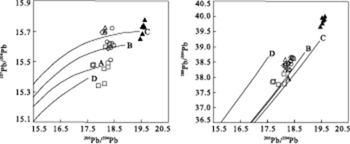
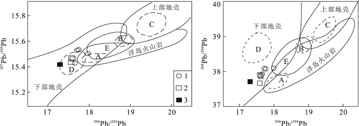
Zhaxikang deposit is the only large Pb-Zn-Sb-Ag symbiotic deposit in the northern Himalayas gold-antimony polymetallic belt, with its ore body located in the high-angle twisting fault zone striking SN direction. The δ34S of pyrite, sphalerite, galena, jamesonite, stibnite ranges from 4.5‰ to 12.0‰, with the majority ranging from 8‰ to 11‰, and it is enriched in sulfur with a narrow range, indicating that the same sulfur source, mainly from the rock formation in the marine sulfur reduction. The ratio of 206Pb/204Pb, 207Pb/204Pb and 208Pb/204Pb is at 18.474-19.637, 15.649-15.774 and 39.660-40.010 respectively, falling near the upper crust of lead evolution line within the investment plan, and into a straight line. δDV-SMOW values of water in fluid inclusions of quartz varies from -127‰ to -135‰, δ18OH2O to -13.7‰ to 12.4‰, in the distribution of geothermal water in Tibet. He-Ar isotopes shows that the ore-forming fluid was mainly derived from rustal fluids and saturated meteoric water, and apparently there is no mixing mantle fluid composition. The multi-isotope composition of the deposit has significant difference with gold or gold-antimony deposit in North Himalayan metallogenic belt, which indicates its unique mineralization of Zhaxikang deposits. As the Indian plate colliding to Eurasian plate in Miocene post-collisional transition environment from intra-continental orogeny to extension slip in North Himalayan belt, there formed a series of high-angle fault zones of SN direction, causing partial melting of crust which increased local heat flux sharply and geothermal gradient anomalies driving groundwater convection cycle, extracting metallogenic elements from Late Triassic-Early Cretaceous turbidite or black carbon and silicon gray mudstone strata The deposit formed by replacement and filling along the SN fault zone, which belongs to sedimentary-structural-geothermal water multi-stage replacement and hydrothermal vein deposits.
Zhaxikang deposit is the only large Pb-Zn-Sb-Ag symbiotic deposit in the northern Himalayas gold-antimony polymetallic belt, with its ore body located in the high-angle twisting fault zone striking SN direction. The δ34S of pyrite, sphalerite, galena, jamesonite, stibnite ranges from 4.5‰ to 12.0‰, with the majority ranging from 8‰ to 11‰, and it is enriched in sulfur with a narrow range, indicating that the same sulfur source, mainly from the rock formation in the marine sulfur reduction. The ratio of 206Pb/204Pb, 207Pb/204Pb and 208Pb/204Pb is at 18.474-19.637, 15.649-15.774 and 39.660-40.010 respectively, falling near the upper crust of lead evolution line within the investment plan, and into a straight line. δDV-SMOW values of water in fluid inclusions of quartz varies from -127‰ to -135‰, δ18OH2O to -13.7‰ to 12.4‰, in the distribution of geothermal water in Tibet. He-Ar isotopes shows that the ore-forming fluid was mainly derived from rustal fluids and saturated meteoric water, and apparently there is no mixing mantle fluid composition. The multi-isotope composition of the deposit has significant difference with gold or gold-antimony deposit in North Himalayan metallogenic belt, which indicates its unique mineralization of Zhaxikang deposits. As the Indian plate colliding to Eurasian plate in Miocene post-collisional transition environment from intra-continental orogeny to extension slip in North Himalayan belt, there formed a series of high-angle fault zones of SN direction, causing partial melting of crust which increased local heat flux sharply and geothermal gradient anomalies driving groundwater convection cycle, extracting metallogenic elements from Late Triassic-Early Cretaceous turbidite or black carbon and silicon gray mudstone strata The deposit formed by replacement and filling along the SN fault zone, which belongs to sedimentary-structural-geothermal water multi-stage replacement and hydrothermal vein deposits.


2010, 35(6): 1011-1022.
doi: 10.3799/dqkx.2010.114
Abstract:
Zircon U-Pb isotopic ages of Jinduicheng and Laoniushan granite are measured by LA-ICP-MS techniques, and we find that the mean ages are 143.7±3 Ma and 144.5±4.4 Ma respectively, which correspond to the molybdenite Re-Os age 139±3.0 Ma of Jinduicheng molybdenite polymetallic deposit. It indicates that the diagenetic and metallogenic ages of Jinduicheng deposit are between Jurassic and Cretaceous, related with Yanshan movement. Granites in Jinduicheng are richer in SiO2, K2O than those in Laoniushan. The geochemical data demonstrate that Jinduicheng and Laoniushan granites are both characterized with high Si, rich alkali, peraluminous rock series and the calcium alkaline rock series, which indicate that the rock-bodies belong to the continental crust granite; the high εSr (t), low εNd(t), and the Pb isotope values prove the main source of the rock-bodies is partial melting of lower continental-crust materials. The chronology and the litho-geochemical data confirm that Laoniushan and Jinduicheng granite are the same magma source area, and it is concluded that Laoniushan rock body has provided mass hydrothermal and mineral substance in depth for the small Jinduicheng rock body, which in turn led to the phenomenon of the Jinduicheng small rock body containing large ore deposit.
Zircon U-Pb isotopic ages of Jinduicheng and Laoniushan granite are measured by LA-ICP-MS techniques, and we find that the mean ages are 143.7±3 Ma and 144.5±4.4 Ma respectively, which correspond to the molybdenite Re-Os age 139±3.0 Ma of Jinduicheng molybdenite polymetallic deposit. It indicates that the diagenetic and metallogenic ages of Jinduicheng deposit are between Jurassic and Cretaceous, related with Yanshan movement. Granites in Jinduicheng are richer in SiO2, K2O than those in Laoniushan. The geochemical data demonstrate that Jinduicheng and Laoniushan granites are both characterized with high Si, rich alkali, peraluminous rock series and the calcium alkaline rock series, which indicate that the rock-bodies belong to the continental crust granite; the high εSr (t), low εNd(t), and the Pb isotope values prove the main source of the rock-bodies is partial melting of lower continental-crust materials. The chronology and the litho-geochemical data confirm that Laoniushan and Jinduicheng granite are the same magma source area, and it is concluded that Laoniushan rock body has provided mass hydrothermal and mineral substance in depth for the small Jinduicheng rock body, which in turn led to the phenomenon of the Jinduicheng small rock body containing large ore deposit.


2010, 35(6): 1023-1028.
doi: 10.3799/dqkx.2010.115
Abstract:
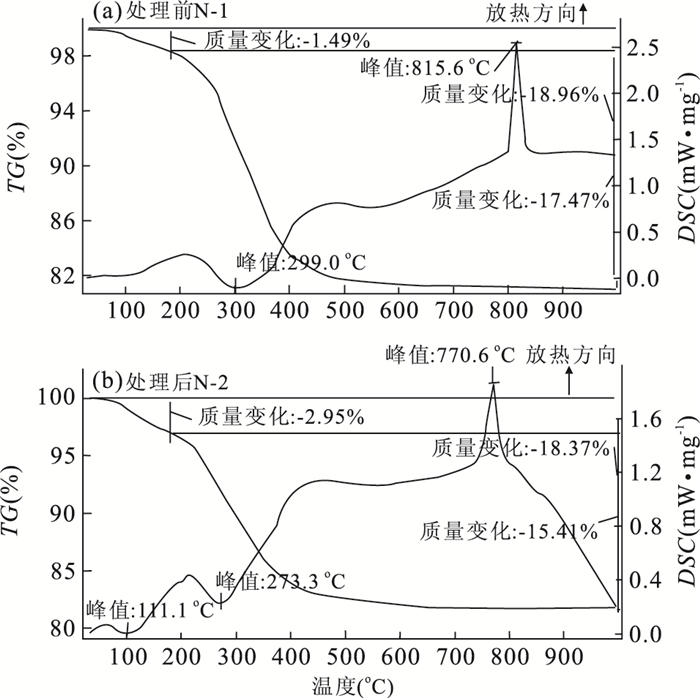
The quality grade, gemology characteristics, cutting and grinding processing of the loosen turquoises filled with aluminum phosphate adhesive are improved distinctly, and consequently they are similar with the natural turquoises. They can not be identified easily by gemmology testing methods. In order to verify the structure of this kind of modified turquoises and discuss the mechanism of the turquoises improved by the aluminium phosphate inorganic adhesive, the environmental scanning electron microscope (ESEM), thermogravimetric and thermal analysis (TG-DSC), infrared spectrum (IR) and X-ray powder diffraction (XRD) have been used to study the structural characteristics, phase, and thermal property of the turquoises filled with aluminum phosphate adhesive. It is indicated that the micro-pores of the turquoises after treatment are completely filled by aluminum phosphate adhesive as gelatinous, and the mineral composition and molecular structure of turquoises show no noticeable changes, but is amorphous in a degree. The amorphous structure is relevant with the filling of aluminum phosphate that is the inorganic polymer network structure forms when the aluminum phosphate adhesive is dehydrated. Moreover, the endothermic and exothermic reaction temperatures of the turquoises after treatment fall in certain degree than the natural ones caused by the addition of aluminum phosphate.
The quality grade, gemology characteristics, cutting and grinding processing of the loosen turquoises filled with aluminum phosphate adhesive are improved distinctly, and consequently they are similar with the natural turquoises. They can not be identified easily by gemmology testing methods. In order to verify the structure of this kind of modified turquoises and discuss the mechanism of the turquoises improved by the aluminium phosphate inorganic adhesive, the environmental scanning electron microscope (ESEM), thermogravimetric and thermal analysis (TG-DSC), infrared spectrum (IR) and X-ray powder diffraction (XRD) have been used to study the structural characteristics, phase, and thermal property of the turquoises filled with aluminum phosphate adhesive. It is indicated that the micro-pores of the turquoises after treatment are completely filled by aluminum phosphate adhesive as gelatinous, and the mineral composition and molecular structure of turquoises show no noticeable changes, but is amorphous in a degree. The amorphous structure is relevant with the filling of aluminum phosphate that is the inorganic polymer network structure forms when the aluminum phosphate adhesive is dehydrated. Moreover, the endothermic and exothermic reaction temperatures of the turquoises after treatment fall in certain degree than the natural ones caused by the addition of aluminum phosphate.


2010, 35(6): 1029-1034.
doi: 10.3799/dqkx.2010.116
Abstract:
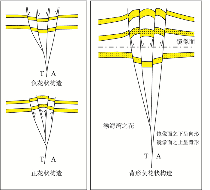
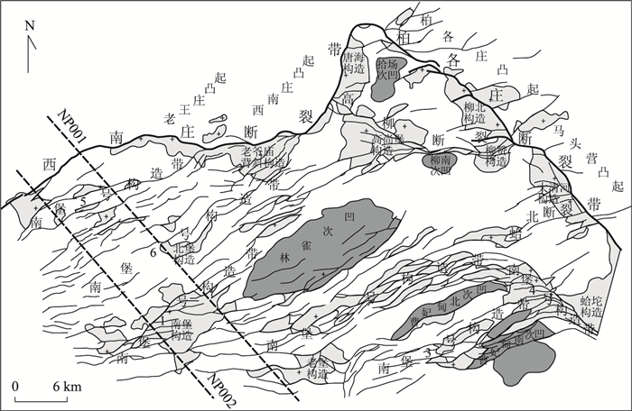
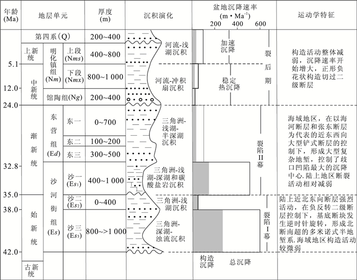
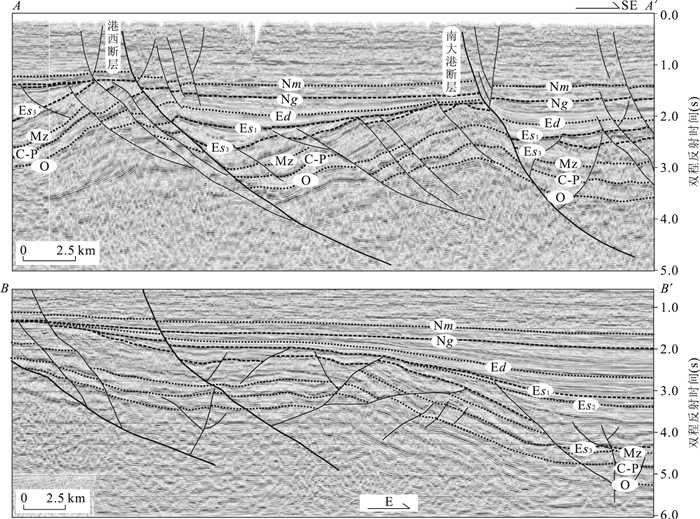
Flower structures are specific modes of formation, and their distinctive characteristics make them important criteria for the identification of a strike-slip zone in vertical cross-sections and on seismic profiles. Two element types of the classical flower structures were respectively negative and positive flower structures. There is a new kind of flower structure termed antiformal negative flower structures in Nanpu sag, Bohai Bay basin. A antiformal negative flower structure in 3D seismic profiles from the Nanpu sag consists of a shallow antiform and a deep synform bounded by upward and outward spreading strands of a strike-slip fault that have mostly normal separations. In map-view, the folds and associated normal faults present an en echelon arrangement. Antiformal negative flower structure formed in the transtensional setting of Nanpu sag. The shallow antiform is forced folds caused by the transtensional faults dragging cover into folds. Antiformal negative flower structure undergone two phases of deformation including: (1) forming of drag fold and (2) fualting and collapsing of the fold crest. The antiformal negative flower structures are a widespread structural styles in the Neogene of the Bohai Bay basin.
Flower structures are specific modes of formation, and their distinctive characteristics make them important criteria for the identification of a strike-slip zone in vertical cross-sections and on seismic profiles. Two element types of the classical flower structures were respectively negative and positive flower structures. There is a new kind of flower structure termed antiformal negative flower structures in Nanpu sag, Bohai Bay basin. A antiformal negative flower structure in 3D seismic profiles from the Nanpu sag consists of a shallow antiform and a deep synform bounded by upward and outward spreading strands of a strike-slip fault that have mostly normal separations. In map-view, the folds and associated normal faults present an en echelon arrangement. Antiformal negative flower structure formed in the transtensional setting of Nanpu sag. The shallow antiform is forced folds caused by the transtensional faults dragging cover into folds. Antiformal negative flower structure undergone two phases of deformation including: (1) forming of drag fold and (2) fualting and collapsing of the fold crest. The antiformal negative flower structures are a widespread structural styles in the Neogene of the Bohai Bay basin.


2010, 35(6): 1035-1040.
doi: 10.3799/dqkx.2010.117
Abstract:
Our study on two typical intra-cratonic basins, namely, Ordos basin, China and Surat basin, Australia indicates that the sequence stratigraphic infilling succession is correlated, The study results show that intra-cratonic basin has unique stratigraphic infilling characteristics, such as (1) typical fining-upward lithology association successions with a sandstone-rich lower part and a mudstone-rich upper part; (2) asymmetrical base level cycle mainly composed of ascending half cycle, with the characteristic of long term transgression and short term regression; (3) sequence stratigraphy made up primarily of a lowstand system tract with multistorey stacked sandstones forming excellent reservoir quality, and little deposition of transgressive system tract and highstand systems tract with isolated sandstones within mud-dominated deposits forming medium or poor reservoir. The spatial and temporal distributions of sequence stratigraphy and sandstones in the intra-cratonic basin are characterized by the source-ward retrogradation controlled by structure action of basin margin, sediment supply, eustasy, palaeotopography, basin infilling, climate, or integrated influence of above-listed factors.
Our study on two typical intra-cratonic basins, namely, Ordos basin, China and Surat basin, Australia indicates that the sequence stratigraphic infilling succession is correlated, The study results show that intra-cratonic basin has unique stratigraphic infilling characteristics, such as (1) typical fining-upward lithology association successions with a sandstone-rich lower part and a mudstone-rich upper part; (2) asymmetrical base level cycle mainly composed of ascending half cycle, with the characteristic of long term transgression and short term regression; (3) sequence stratigraphy made up primarily of a lowstand system tract with multistorey stacked sandstones forming excellent reservoir quality, and little deposition of transgressive system tract and highstand systems tract with isolated sandstones within mud-dominated deposits forming medium or poor reservoir. The spatial and temporal distributions of sequence stratigraphy and sandstones in the intra-cratonic basin are characterized by the source-ward retrogradation controlled by structure action of basin margin, sediment supply, eustasy, palaeotopography, basin infilling, climate, or integrated influence of above-listed factors.


2010, 35(6): 1041-1052.
doi: 10.3799/dqkx.2010.118
Abstract:
The middle and north area of Huanghua depression, located in the middle of the Bohai Bay basin, is a significant Cenozoic tectonic unit. This study area underwent the episodic subsidence and the subsidence center migrated regularly which was interpreted through the analysis of the tectonic-sequence surface, syn-sedimentary fault's activity and the back-stripping of the subsidence history. The bottom interface of Guantao Formation is a regional post-rifting unconformity surface and divides the basin's Cenozoic evolution into rifting and post-rifting stage. In the filling sequence of the rifting stage, the bottom interface of the first member of Shahejie Formation is also a regional recognizable angle disconformity surface in the whole basin and divides the rifting stage into Episodic Ⅰ and Episodic Ⅱ. The geometry feature and property of the fault system shows that the tectonic deformation of the study area was controlled by the NW-SE extending stress field in the rifting Episodic Ⅰ from Es3 to Es2. However, the extending stress field turned to NS in the Episodic Ⅱ from Es1 to Ed. In the post-rifting stage, the middle and north area of Huanghua depression underwent stable subsidence at early stage and accelerated subsidence at late stage. This episodic subsidence process is closely related to the change of the regional extending stress field orientation which was controlled by the tectonic events of the surrounding plates. Especially, the accelerated westward subduction from the Pacific Plate to the Eurasia Plate triggered the southward expanding of the dextral slipping of the Tanlu fault and the activity of the north section of the Lanliao fault through the Huanghua depression after the Late Eocene. The continued dextral slipping between the east and west boundary faults created a NS trending extensional overlap at the Bohai Sea, completely changed the stress field distribution in the middle and north area of Huanghua depression, and generated the episodic evolution in the rifting stage.
The middle and north area of Huanghua depression, located in the middle of the Bohai Bay basin, is a significant Cenozoic tectonic unit. This study area underwent the episodic subsidence and the subsidence center migrated regularly which was interpreted through the analysis of the tectonic-sequence surface, syn-sedimentary fault's activity and the back-stripping of the subsidence history. The bottom interface of Guantao Formation is a regional post-rifting unconformity surface and divides the basin's Cenozoic evolution into rifting and post-rifting stage. In the filling sequence of the rifting stage, the bottom interface of the first member of Shahejie Formation is also a regional recognizable angle disconformity surface in the whole basin and divides the rifting stage into Episodic Ⅰ and Episodic Ⅱ. The geometry feature and property of the fault system shows that the tectonic deformation of the study area was controlled by the NW-SE extending stress field in the rifting Episodic Ⅰ from Es3 to Es2. However, the extending stress field turned to NS in the Episodic Ⅱ from Es1 to Ed. In the post-rifting stage, the middle and north area of Huanghua depression underwent stable subsidence at early stage and accelerated subsidence at late stage. This episodic subsidence process is closely related to the change of the regional extending stress field orientation which was controlled by the tectonic events of the surrounding plates. Especially, the accelerated westward subduction from the Pacific Plate to the Eurasia Plate triggered the southward expanding of the dextral slipping of the Tanlu fault and the activity of the north section of the Lanliao fault through the Huanghua depression after the Late Eocene. The continued dextral slipping between the east and west boundary faults created a NS trending extensional overlap at the Bohai Sea, completely changed the stress field distribution in the middle and north area of Huanghua depression, and generated the episodic evolution in the rifting stage.


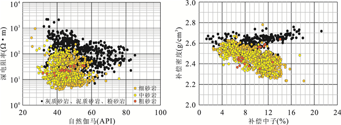
2010, 35(6): 1053-1059.
doi: 10.3799/dqkx.2010.119
Abstract:
The fourth and sixth members of upper Triassic Xujiahe Formation develop structural, structural-lithological and lithological reservoirs with characteristics of low porosity, permeability, resistivity and high irreducible water saturation in Guang'an gasfield of Sichuan basin, southwestern China. In space, relationship of the reservoir porosity and permeability varies greatly, and the reservoir gas and water distribution is complex, resulting in difficulty in gas and water pay recognition. Based on the core calibration of logging data, relationships among lithology, logging characterization, petrophysical property and gas-bearing capacity of the target zones were explored. It can be concluded that the reservoirs are made up of fine, medium- and coarse-grained sandstones with characteristics of low values of gamma ray, density and resistivity and high values of sonic, while the porosity and permeability show no correlation with gas-bearing capacity. The porosity and permeability model were established by considering the sixth and fourth members of Xujiahe Formation separately and subdividing the study area into four blocks, which improves precision of the porosity and permeability interpretation. On the recognition that different gas reservoir types have different gas and water distributions, three methods of high definition induction logging, nuclear-magnetic resonance logging and comprehensive discrimination were jointly applied to distinguish gas and water pays, which increases the accuracy of gas and water pay identification. The application of these methods in the Guang'an gasfield show they are suitable for gas and water pay recognition of structural and structural-lithological reservoirs, whereas not feasible for lithological reservoirs with low structural magnitude whose water saturations of gas pay are transitional with those of water and gas- and water-bearing pay due to incomplete separation of gas and water.
The fourth and sixth members of upper Triassic Xujiahe Formation develop structural, structural-lithological and lithological reservoirs with characteristics of low porosity, permeability, resistivity and high irreducible water saturation in Guang'an gasfield of Sichuan basin, southwestern China. In space, relationship of the reservoir porosity and permeability varies greatly, and the reservoir gas and water distribution is complex, resulting in difficulty in gas and water pay recognition. Based on the core calibration of logging data, relationships among lithology, logging characterization, petrophysical property and gas-bearing capacity of the target zones were explored. It can be concluded that the reservoirs are made up of fine, medium- and coarse-grained sandstones with characteristics of low values of gamma ray, density and resistivity and high values of sonic, while the porosity and permeability show no correlation with gas-bearing capacity. The porosity and permeability model were established by considering the sixth and fourth members of Xujiahe Formation separately and subdividing the study area into four blocks, which improves precision of the porosity and permeability interpretation. On the recognition that different gas reservoir types have different gas and water distributions, three methods of high definition induction logging, nuclear-magnetic resonance logging and comprehensive discrimination were jointly applied to distinguish gas and water pays, which increases the accuracy of gas and water pay identification. The application of these methods in the Guang'an gasfield show they are suitable for gas and water pay recognition of structural and structural-lithological reservoirs, whereas not feasible for lithological reservoirs with low structural magnitude whose water saturations of gas pay are transitional with those of water and gas- and water-bearing pay due to incomplete separation of gas and water.


2010, 35(6): 1060-1068.
doi: 10.3799/dqkx.2010.120
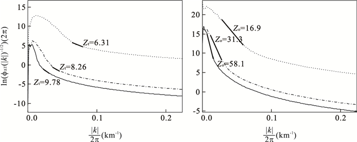
Abstract:
In order to investigate thermal state of crust in northern continental margin of the South China Sea, we calculated the Curie point depths with the shipboard magnetic anomaly by employing the method of power-density spectrum analysis. Combining with the seismic section, faults, and the heat flow distribution, the deep thermal structure was discussed in the study area. The result shows that Curie point depths were between 13 and 26 km. NE-directed faults were mostly distributed in the gradient belt of Curie point isotherm, while NW-directed faults had the features of segmentation and fragment. The correlations were apparent between the Curie point depths and heat flow data. It reveals that magnetic bodies in shelf and upper slope were mostly distributed over upper crust and upper part of lower crust; and the crust and the top of mantle in under slope and the oceanic areas were subject to magnetization. Magnetic quiet zone was located at the margin of the uplift of the Curie point isotherm. Residue ancient oceanic crusts extended from F3 fault to F4 fault. Chaoshan depression and centre uplift of the Southwest Taiwan basin were the main areas of underplating, and F2 fault was the north boundary.
In order to investigate thermal state of crust in northern continental margin of the South China Sea, we calculated the Curie point depths with the shipboard magnetic anomaly by employing the method of power-density spectrum analysis. Combining with the seismic section, faults, and the heat flow distribution, the deep thermal structure was discussed in the study area. The result shows that Curie point depths were between 13 and 26 km. NE-directed faults were mostly distributed in the gradient belt of Curie point isotherm, while NW-directed faults had the features of segmentation and fragment. The correlations were apparent between the Curie point depths and heat flow data. It reveals that magnetic bodies in shelf and upper slope were mostly distributed over upper crust and upper part of lower crust; and the crust and the top of mantle in under slope and the oceanic areas were subject to magnetization. Magnetic quiet zone was located at the margin of the uplift of the Curie point isotherm. Residue ancient oceanic crusts extended from F3 fault to F4 fault. Chaoshan depression and centre uplift of the Southwest Taiwan basin were the main areas of underplating, and F2 fault was the north boundary.


2010, 35(6): 1069-1074.
doi: 10.3799/dqkx.2010.121
Abstract:
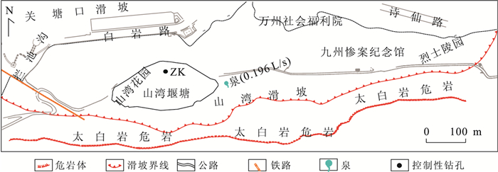
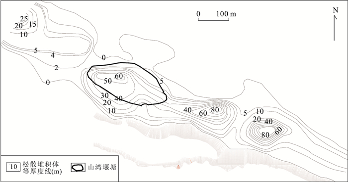
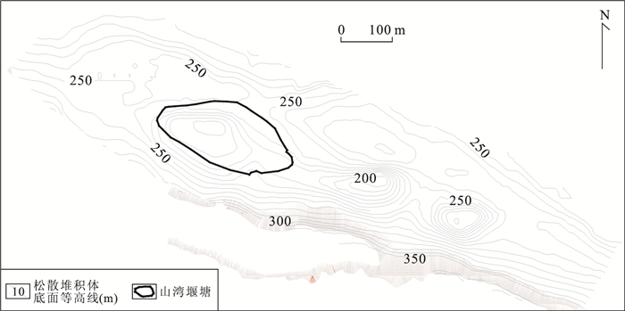
The interaction of fluvial geomorphology evolution and special geological environment in horizontal formation in Wanzhou district resulted in its unique stepladder geomorphic feature. Based on a systematic field investigation, exploration and data collection, combining with the drilling at Shanwan pond in 2008, we conducted a comprehensive study of its sediment for the first time, systematically collecting sediment samples, doing analysis to determine its age and composition. It shows the consistency of Shanwan cliff collapse and the regional tectonism. The sediment profile of Shanwan landslide collapse deposit at each stage is presented and it is divided into 10 cycles of failure. Combining with the sediment dating, the deposition rate of Shanwan landslide sediment is researched, and the recession rate of Shanwan cliff is proposed as 0.31-0.37 m/ka.
The interaction of fluvial geomorphology evolution and special geological environment in horizontal formation in Wanzhou district resulted in its unique stepladder geomorphic feature. Based on a systematic field investigation, exploration and data collection, combining with the drilling at Shanwan pond in 2008, we conducted a comprehensive study of its sediment for the first time, systematically collecting sediment samples, doing analysis to determine its age and composition. It shows the consistency of Shanwan cliff collapse and the regional tectonism. The sediment profile of Shanwan landslide collapse deposit at each stage is presented and it is divided into 10 cycles of failure. Combining with the sediment dating, the deposition rate of Shanwan landslide sediment is researched, and the recession rate of Shanwan cliff is proposed as 0.31-0.37 m/ka.


2010, 35(6): 1075-1080.
doi: 10.3799/dqkx.2010.122
Abstract:
To ensure the geological security for the development of urban planning of facility-sliding strata of Badong Formation in the Three Gorges reservoir area, we discuss the geological environment development and protection issues in abnormal slope areas by means of system analysis and analogy. Loess landslide in Badong City is a super complex deformable body formed by multi-stages, and systematic analysis indicates that under the condition of the operation of Three Gorges reservoir, the loess landslide is nearly in whole stability except the front which can be put to restrictive use.So part of relocation is necessary and appropriate. Generally speaking, the new site area and the loess landslide share similar geological environment, belonging to the slope geological environment of the Three Gorges reservoir area characterized by facility-sliding strata of Badong Formation and consequent slope structure. The development of a large number of influential landslides reveals a more vulnerable side of the geological environment, and as a result it can only be subject to restrictive use. Strengthening the construction of geological disaster prevention system and risk management can control the risk level of the planning and development in allowed geologically secure conditions.
To ensure the geological security for the development of urban planning of facility-sliding strata of Badong Formation in the Three Gorges reservoir area, we discuss the geological environment development and protection issues in abnormal slope areas by means of system analysis and analogy. Loess landslide in Badong City is a super complex deformable body formed by multi-stages, and systematic analysis indicates that under the condition of the operation of Three Gorges reservoir, the loess landslide is nearly in whole stability except the front which can be put to restrictive use.So part of relocation is necessary and appropriate. Generally speaking, the new site area and the loess landslide share similar geological environment, belonging to the slope geological environment of the Three Gorges reservoir area characterized by facility-sliding strata of Badong Formation and consequent slope structure. The development of a large number of influential landslides reveals a more vulnerable side of the geological environment, and as a result it can only be subject to restrictive use. Strengthening the construction of geological disaster prevention system and risk management can control the risk level of the planning and development in allowed geologically secure conditions.


