


2011 Vol. 36, No. 2
Display Method:
2011, 36(2): 181-188.
doi: 10.3799/dqkx.2011.019
 PDF 433KB
Abstract:
Scientific targeting is a successful key for exploration of both the concealed and new type of mineral deposits. Geological anomaly areas with complex structures in the crust can be defined as preferable ore-finding areas based on the theory of ore-forming geoanomaly. Areas where critical ore-forming factors such as thermal energy and ore-fluid source, plumbing fluid systems, trap (depositional) site, and fluid seal (cap) are well developed within the preferable ore-finding areas can be defined as potential mineral resource areas based on the theory of ore-forming system. Areas where association of ore deposits may exist can be defined as perspective ore-finding areas based on the theory of ore-forming series. This study demonstrates that both hierarchy and heterogeneity of the spatial and temporal distribution of ore deposits and their power-law size frequency distribution in individual province as well as the largest deposits discovered generally in the early phases of mineral exploration of a terrain lay a theoretical foundation of the telescoping ore deposits at multiple exploration scales. Ambiguity and uncertainty of ore-finding information from single discipline make it necessary to explore ore deposits using integrated ore-finding information from multi-disciplines such as geology, geochemistry, geophysics and remote sensing image. Probabilistic modeling techniques based on both ore-forming system model and integrated ore-finding pattern are the best approaches to assess mineral potentials of ore-finding target areas from two aspects of both ore-forming essence and phenomenon.
Scientific targeting is a successful key for exploration of both the concealed and new type of mineral deposits. Geological anomaly areas with complex structures in the crust can be defined as preferable ore-finding areas based on the theory of ore-forming geoanomaly. Areas where critical ore-forming factors such as thermal energy and ore-fluid source, plumbing fluid systems, trap (depositional) site, and fluid seal (cap) are well developed within the preferable ore-finding areas can be defined as potential mineral resource areas based on the theory of ore-forming system. Areas where association of ore deposits may exist can be defined as perspective ore-finding areas based on the theory of ore-forming series. This study demonstrates that both hierarchy and heterogeneity of the spatial and temporal distribution of ore deposits and their power-law size frequency distribution in individual province as well as the largest deposits discovered generally in the early phases of mineral exploration of a terrain lay a theoretical foundation of the telescoping ore deposits at multiple exploration scales. Ambiguity and uncertainty of ore-finding information from single discipline make it necessary to explore ore deposits using integrated ore-finding information from multi-disciplines such as geology, geochemistry, geophysics and remote sensing image. Probabilistic modeling techniques based on both ore-forming system model and integrated ore-finding pattern are the best approaches to assess mineral potentials of ore-finding target areas from two aspects of both ore-forming essence and phenomenon.

2011, 36(2): 189-200.
doi: 10.3799/dqkx.2011.020
Abstract:
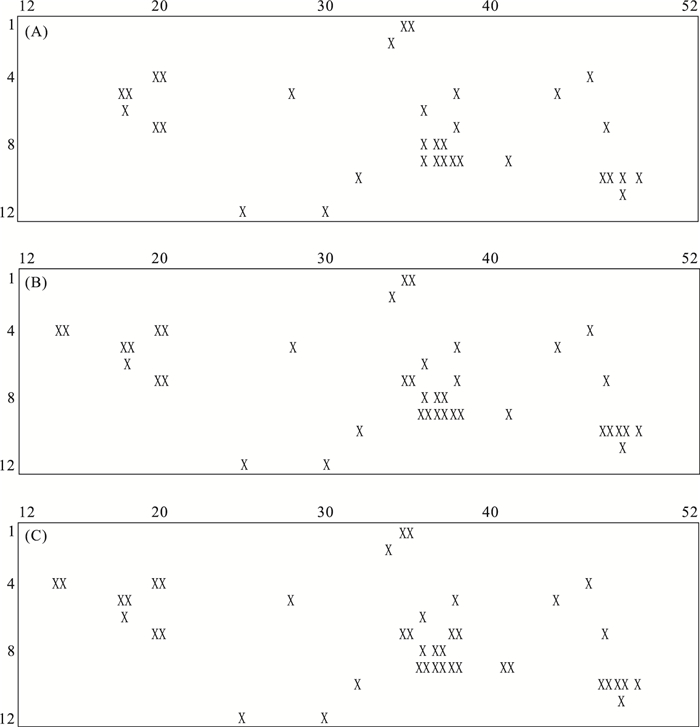
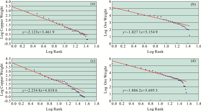
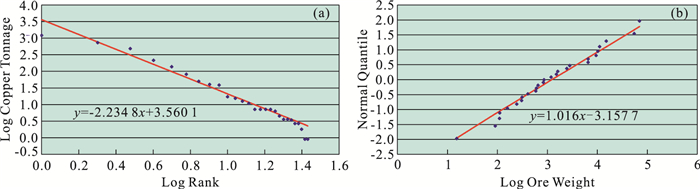
Five principal sources of uncertainty in quantitative mineral resource estimation are listed and illustrated by means of a simple example (mosaic model) and a case history study for large copper deposits in the Abitibi area of the Canadian Shield. Abitibi copper potential originally was estimated on the basis of 1968 estimates of production and reserves totalling 3.12 Mt Cu. This prognostication now could be evaluated on the basis of 2008 copper production and reserves totalling 9.50 Mt Cu. An earlier hindsight study performed on the basis of 1977 data (totalling 5.23 Mt Cu) showed seven new discoveries occurring either in the immediate vicinities of known deposits or on broad regional copper anomalies predicted from the 1968 inputs. By 1977, the global geographic distribution pattern of large copper deposits in the Abitibi area had stabilized. During the next 30 years, new copper was essentially found close to existing deposits, much of it deeper down in the Earth's crust. In this paper, uncertainties associated with copper ore tonnage are analyzed by comparison of 2008 data with 1968 data using (a) log-log plots of size versus rank, and (b) lognormal QQ-plots. Straight lines fitted by least squares on these plots show that 1968 slopes provide good estimates of 2008 slopes but 1968 intercepts are much less than 2008 intercepts. In each linear log-weight versus log-rank plot, the slope is related to fractal dimension of a Pareto frequency distribution, and in a lognormal QQ-plot it is determined by logarithmic variance. The difference between 2008 and 1968 intercepts represents the increase in copper ore production and reserves from 1968 to 2008. The Pareto model fits actual copper and massive sulphides increase over the past 40 years better than the lognormal frequency distribution model for 10 km×10 km cells on favorable environments in the Abitibi area.
Five principal sources of uncertainty in quantitative mineral resource estimation are listed and illustrated by means of a simple example (mosaic model) and a case history study for large copper deposits in the Abitibi area of the Canadian Shield. Abitibi copper potential originally was estimated on the basis of 1968 estimates of production and reserves totalling 3.12 Mt Cu. This prognostication now could be evaluated on the basis of 2008 copper production and reserves totalling 9.50 Mt Cu. An earlier hindsight study performed on the basis of 1977 data (totalling 5.23 Mt Cu) showed seven new discoveries occurring either in the immediate vicinities of known deposits or on broad regional copper anomalies predicted from the 1968 inputs. By 1977, the global geographic distribution pattern of large copper deposits in the Abitibi area had stabilized. During the next 30 years, new copper was essentially found close to existing deposits, much of it deeper down in the Earth's crust. In this paper, uncertainties associated with copper ore tonnage are analyzed by comparison of 2008 data with 1968 data using (a) log-log plots of size versus rank, and (b) lognormal QQ-plots. Straight lines fitted by least squares on these plots show that 1968 slopes provide good estimates of 2008 slopes but 1968 intercepts are much less than 2008 intercepts. In each linear log-weight versus log-rank plot, the slope is related to fractal dimension of a Pareto frequency distribution, and in a lognormal QQ-plot it is determined by logarithmic variance. The difference between 2008 and 1968 intercepts represents the increase in copper ore production and reserves from 1968 to 2008. The Pareto model fits actual copper and massive sulphides increase over the past 40 years better than the lognormal frequency distribution model for 10 km×10 km cells on favorable environments in the Abitibi area.


2011, 36(2): 201-208.
doi: 10.3799/dqkx.2011.021
Abstract:
For national or global resource estimation of frequencies of metals, a lognormal distribution has commonly been recommended but not adequately tested. Tests of frequencies of Cu, Zn, Pb, Ag, and Au contents of 1 984 well-explored mineral deposits display a poor fit to the lognormal distribution. When the same metals plus Mo, Co, Nb2O3, and REE2O3 are grouped into 19 geologically defined deposit types, only eight of the 73 tests fail to be fit by lognormal distribution, and most of those failures are in two deposit types suggesting a problem with those types. Estimates of the mean and standard deviation of each of the metals in each of the deposit types are provided for modeling.
For national or global resource estimation of frequencies of metals, a lognormal distribution has commonly been recommended but not adequately tested. Tests of frequencies of Cu, Zn, Pb, Ag, and Au contents of 1 984 well-explored mineral deposits display a poor fit to the lognormal distribution. When the same metals plus Mo, Co, Nb2O3, and REE2O3 are grouped into 19 geologically defined deposit types, only eight of the 73 tests fail to be fit by lognormal distribution, and most of those failures are in two deposit types suggesting a problem with those types. Estimates of the mean and standard deviation of each of the metals in each of the deposit types are provided for modeling.

2011, 36(2): 209-226.
doi: 10.3799/dqkx.2011.022
Abstract:
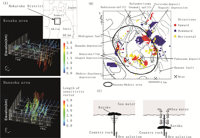
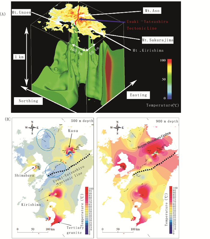
Sample data in the Earth and environmental sciences are limited in quantity and sampling location and therefore, sophisticated spatial modeling techniques are indispensable for accurate imaging of complicated structures and properties of geomaterials. This paper presents several effective methods that are grouped into two categories depending on the nature of regionalized data used. Type I data originate from plural populations and type II data satisfy the prerequisite of stationarity and have distinct spatial correlations. For the type I data, three methods are shown to be effective and demonstrated to produce plausible results: (1) a spline-based method, (2) a combination of a spline-based method with a stochastic simulation, and (3) a neural network method. Geostatistics proves to be a powerful tool for type II data. Three new approaches of geostatistics are presented with case studies: an application to directional data such as fracture, multi-scale modeling that incorporates a scaling law, and space-time joint analysis for multivariate data. Methods for improving the contribution of such spatial modeling to Earth and environmental sciences are also discussed and future important problems to be solved are summarized.
Sample data in the Earth and environmental sciences are limited in quantity and sampling location and therefore, sophisticated spatial modeling techniques are indispensable for accurate imaging of complicated structures and properties of geomaterials. This paper presents several effective methods that are grouped into two categories depending on the nature of regionalized data used. Type I data originate from plural populations and type II data satisfy the prerequisite of stationarity and have distinct spatial correlations. For the type I data, three methods are shown to be effective and demonstrated to produce plausible results: (1) a spline-based method, (2) a combination of a spline-based method with a stochastic simulation, and (3) a neural network method. Geostatistics proves to be a powerful tool for type II data. Three new approaches of geostatistics are presented with case studies: an application to directional data such as fracture, multi-scale modeling that incorporates a scaling law, and space-time joint analysis for multivariate data. Methods for improving the contribution of such spatial modeling to Earth and environmental sciences are also discussed and future important problems to be solved are summarized.


2011, 36(2): 227-235.
doi: 10.3799/dqkx.2011.023
Abstract:
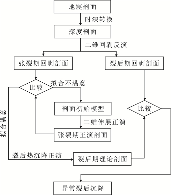
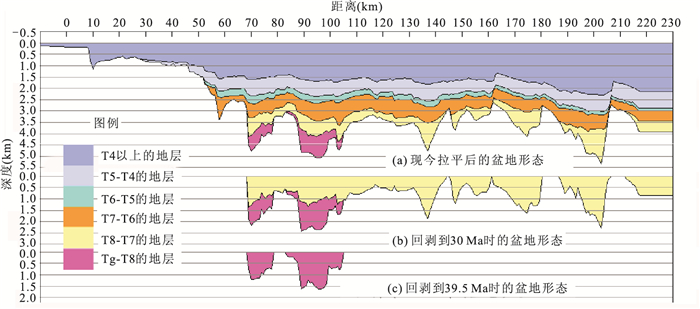
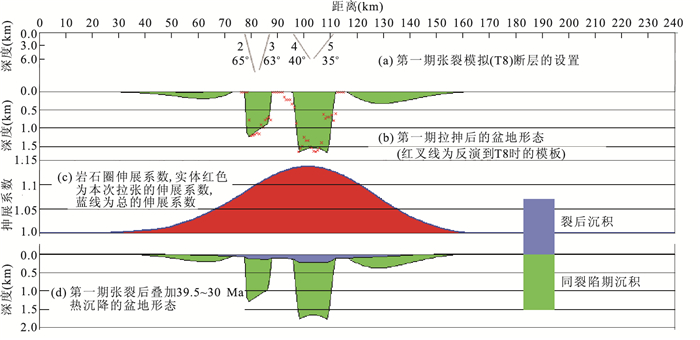
Anomalous post-rifting subsidence, i.e. the post-rifting subsidence larger than the thermal subsidence predicted by the McKenzie model, observed in many extensional sedimentary basins including those in the northern South China Sea. The characterization of anomalous post-rifting subsidence is the first step in understanding its origin and mechanism and its impact on the formation of oil/gas reservoirs. This paper introduces three methods for characterizing anomalous post-rifting subsidence, namely, the paleo-water depth comparison, the strain-rate inversion, and the 2D forward-backward modeling. The conditions, advantages and disadvantages of these methods are discussed. The application of the third method, which is proposed by the authors, in the Pearl River Mouth basin of the northern South China Sea is presented. Taking into account the lithospheric flexural rigidity, the method calculates the lithosphere stretch factor and theoretical thermal subsidence through 2D forward modeling, and then compares the theoretic subsidence with the observed one given by 2D backstripping. Necessary improvements of the method are also discussed.
Anomalous post-rifting subsidence, i.e. the post-rifting subsidence larger than the thermal subsidence predicted by the McKenzie model, observed in many extensional sedimentary basins including those in the northern South China Sea. The characterization of anomalous post-rifting subsidence is the first step in understanding its origin and mechanism and its impact on the formation of oil/gas reservoirs. This paper introduces three methods for characterizing anomalous post-rifting subsidence, namely, the paleo-water depth comparison, the strain-rate inversion, and the 2D forward-backward modeling. The conditions, advantages and disadvantages of these methods are discussed. The application of the third method, which is proposed by the authors, in the Pearl River Mouth basin of the northern South China Sea is presented. Taking into account the lithospheric flexural rigidity, the method calculates the lithosphere stretch factor and theoretical thermal subsidence through 2D forward modeling, and then compares the theoretic subsidence with the observed one given by 2D backstripping. Necessary improvements of the method are also discussed.


2011, 36(2): 236-246.
doi: 10.3799/dqkx.2011.024
Abstract:
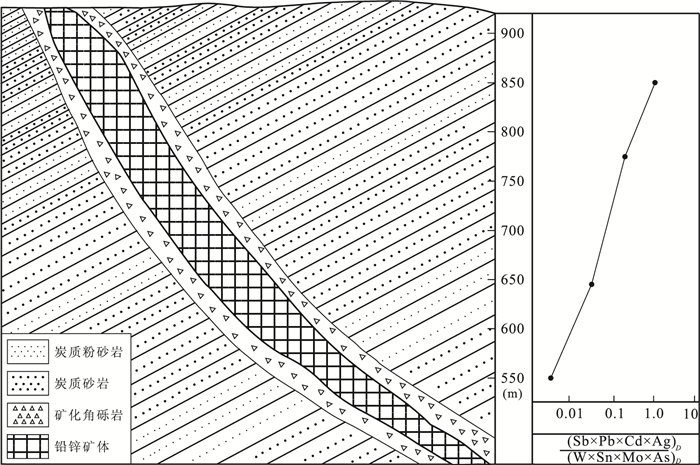
The Huaaobaote Pb-Zn-Ag polymetalic deposit, tectonically located at the south segment of the Dahinggan Mountains ore-forming belt of the circum-western Pacific metallogenetic domain, is a buried hydrothermal vein deposit associated with early Cretaceous tectono-magma activities discovered in recent years. The following conclusions are drawn by studying on primary halos of ore bodies. (1) The ore and halos forming-elements exhibit a clear zonation. Based on their anomalous intensity the transverse element zonation of the ore deposit are established as follows (from high to low): Cd→Pb→Zn→Ag→Sb→In→Hg→As→Cu→Sn→W→Mo→Bi. The five elements (Cd、Pb、Zn、Ag、Sb) ranked in the front of this zoning sequence can be regarded as long range indicators; and the four elements (Sn、W、Mo、Bi)in the rear of this zoning sequence regarded as short range indicators. (2) The axial zonation of this ore deposits is as follows: Sb→Pb→Cd→Ag→Zn→Hg→Cu→In→As→Bi→Sn→Mo→W, which is similar to the standard zonation of hydrothermal ore deposits determined by S.V. Grigorian. (3) Indexes such as (Sb×Pb×Cd×Ag)D/(As×Sn×Mo×W)D are constructed as a criterion for evaluating the ore potential in depth, which is equal or greater than 1.30 on the top portion of the ore bodies, 0.35-0.056 in the middle- upper portion, 0.056-0.005 in the middle-lower portion and equal or lesser than 0.005 at the end portion of the ore bodies, illustrating that the criterion values decrease regularly and abruptly with depth, and they can be used for predicting the ore potentials at a given depth.
The Huaaobaote Pb-Zn-Ag polymetalic deposit, tectonically located at the south segment of the Dahinggan Mountains ore-forming belt of the circum-western Pacific metallogenetic domain, is a buried hydrothermal vein deposit associated with early Cretaceous tectono-magma activities discovered in recent years. The following conclusions are drawn by studying on primary halos of ore bodies. (1) The ore and halos forming-elements exhibit a clear zonation. Based on their anomalous intensity the transverse element zonation of the ore deposit are established as follows (from high to low): Cd→Pb→Zn→Ag→Sb→In→Hg→As→Cu→Sn→W→Mo→Bi. The five elements (Cd、Pb、Zn、Ag、Sb) ranked in the front of this zoning sequence can be regarded as long range indicators; and the four elements (Sn、W、Mo、Bi)in the rear of this zoning sequence regarded as short range indicators. (2) The axial zonation of this ore deposits is as follows: Sb→Pb→Cd→Ag→Zn→Hg→Cu→In→As→Bi→Sn→Mo→W, which is similar to the standard zonation of hydrothermal ore deposits determined by S.V. Grigorian. (3) Indexes such as (Sb×Pb×Cd×Ag)D/(As×Sn×Mo×W)D are constructed as a criterion for evaluating the ore potential in depth, which is equal or greater than 1.30 on the top portion of the ore bodies, 0.35-0.056 in the middle- upper portion, 0.056-0.005 in the middle-lower portion and equal or lesser than 0.005 at the end portion of the ore bodies, illustrating that the criterion values decrease regularly and abruptly with depth, and they can be used for predicting the ore potentials at a given depth.

2011, 36(2): 247-254.
doi: 10.3799/dqkx.2011.025
Abstract:
For many years, porphyry ore deposits have been regarded as the primary sources of the Cu and Mo in a traditional way. However, the geologic conditions of the diagenesis and metallogenesis of the porphyry ore deposits are complex with various mineralization types. Some of the large-superlarge deposits are multielemental and comprehensive. In addition to the Cu, Mo porphyry ore deposits, the metallogenesis and prospecting on nontraditional resources have great potential, including Au, Ag, Sn, W, Bi, Pb, Zn, Re, U, Co, S, Se, Te, PGE, magnetite, etc; rutile and rare metals, such as Ta, Nb are also worth paying attention to. It is of important theoretical value and practical significance to study the diagenesis and metallogenesis of geological background, geological characteristics, mineralization of distribution and the enrichment of a nontraditional view on the porphyry ore deposits; it is meaningful to summarize the indicator of prognosis and assessment on the nontraditional mineral resources, and to guide the prospecting and resource potential assessment on the porphyry ore deposits.
For many years, porphyry ore deposits have been regarded as the primary sources of the Cu and Mo in a traditional way. However, the geologic conditions of the diagenesis and metallogenesis of the porphyry ore deposits are complex with various mineralization types. Some of the large-superlarge deposits are multielemental and comprehensive. In addition to the Cu, Mo porphyry ore deposits, the metallogenesis and prospecting on nontraditional resources have great potential, including Au, Ag, Sn, W, Bi, Pb, Zn, Re, U, Co, S, Se, Te, PGE, magnetite, etc; rutile and rare metals, such as Ta, Nb are also worth paying attention to. It is of important theoretical value and practical significance to study the diagenesis and metallogenesis of geological background, geological characteristics, mineralization of distribution and the enrichment of a nontraditional view on the porphyry ore deposits; it is meaningful to summarize the indicator of prognosis and assessment on the nontraditional mineral resources, and to guide the prospecting and resource potential assessment on the porphyry ore deposits.

2011, (2): 255-261.
doi: 10.3799/dqkx.2011.026
Abstract:
Space-based design features eological data warehouse, unlike the traditional warehouse based on time. The key concept in the design of the multi-dimension model is to choose suitable multi-dimensions, such as spatial, temporal and attribute dimensions, and determine the granularity and measure, according the data requirements of the subject involved. A geohazards data warehouse of the Three Gorges Reservoir Area is built on 5 subjects to integrate the mass data in different space and time scales; the experiments show that the warehouse makes the geohazards prediction more accurate and rapid in two ways: Firstly, it enables fast search of the data since the data are re-organized by geohazards type, alarm levels and data layers; Secondly, it facilitates the discovery of the geohazards laws from data warehouse through the data mining tools.
Space-based design features eological data warehouse, unlike the traditional warehouse based on time. The key concept in the design of the multi-dimension model is to choose suitable multi-dimensions, such as spatial, temporal and attribute dimensions, and determine the granularity and measure, according the data requirements of the subject involved. A geohazards data warehouse of the Three Gorges Reservoir Area is built on 5 subjects to integrate the mass data in different space and time scales; the experiments show that the warehouse makes the geohazards prediction more accurate and rapid in two ways: Firstly, it enables fast search of the data since the data are re-organized by geohazards type, alarm levels and data layers; Secondly, it facilitates the discovery of the geohazards laws from data warehouse through the data mining tools.


2011, 36(2): 262-276.
doi: 10.3799/dqkx.2011.027
Abstract:
The research about Tethys along the eastern boundary of the Qinghai-Tebit plateau arouses great interests of geologists from all over the world. However, geological jobs keep relatively inadequate and decentralized in the Sanjiang-Indo-China multinational area. Therefore, under the Tethyan tectonic background, it is significant to determine rules of tectonic geography and mineralization of the Tethyan ophiolite complex belt, and to discover the direct evidence of ocean plates based on the former research including its stratigraphy, petrology, structural geology and paleontology. Our study covers the following aspects: (1) The suture location and the subduction direction of different periods are concluded by connecting the tectonic magma belts with the orogenic belt. A geometric pattern of a more fragmentary ophiolite geography of the paleo-Tethys contrasting to that of meso-neo-Tethys can be found easily from the paleogeography. (2) The initial location of sutures greatly changed by events of Indo-Chinese epoch, Yanshanian epoch, and Himalayan epoch can be concluded from our research of the typical ophiolite outcrop area. (3) The formation and distribution of some important mineral resources are obviously controlled by the ophiolite complex belt. The ultra basic rock belts provide the ore material resources of magmatic cobalt and nickel metallogenic belt. The large area of acid magma formed during the course of the close and collision of plates, parallel to the ophiolite belt, is the important material resource of the hydrothermal wolfram and tin deposit belts. The formation of the regional hydrothermal deposits was improved by the transition of tectonic system around the Miocene.
The research about Tethys along the eastern boundary of the Qinghai-Tebit plateau arouses great interests of geologists from all over the world. However, geological jobs keep relatively inadequate and decentralized in the Sanjiang-Indo-China multinational area. Therefore, under the Tethyan tectonic background, it is significant to determine rules of tectonic geography and mineralization of the Tethyan ophiolite complex belt, and to discover the direct evidence of ocean plates based on the former research including its stratigraphy, petrology, structural geology and paleontology. Our study covers the following aspects: (1) The suture location and the subduction direction of different periods are concluded by connecting the tectonic magma belts with the orogenic belt. A geometric pattern of a more fragmentary ophiolite geography of the paleo-Tethys contrasting to that of meso-neo-Tethys can be found easily from the paleogeography. (2) The initial location of sutures greatly changed by events of Indo-Chinese epoch, Yanshanian epoch, and Himalayan epoch can be concluded from our research of the typical ophiolite outcrop area. (3) The formation and distribution of some important mineral resources are obviously controlled by the ophiolite complex belt. The ultra basic rock belts provide the ore material resources of magmatic cobalt and nickel metallogenic belt. The large area of acid magma formed during the course of the close and collision of plates, parallel to the ophiolite belt, is the important material resource of the hydrothermal wolfram and tin deposit belts. The formation of the regional hydrothermal deposits was improved by the transition of tectonic system around the Miocene.


2011, 36(2): 277-281.
doi: 10.3799/dqkx.2011.028
Abstract:
In this paper, tin-copper polymetallic deposit in western low of east part of Gejiu is studied through a systematic analysis of its geological setting, geological characteristics of the deposit, characteristics of alterations zoning, geochemical component of altered granite, and deep exploration experience. The results show that the deposit is a part of diverse magmatic hydrothermal mineralization system, which often occurs in the inner altered granite, especially the edge and transition facies. It is a high-temperature magmatic hydrothermal deposit combining with the post-gas-liquid mineralization by the decomposition and gasification of magma in early stage and the alteration of magma intrusion in later stage. The deposit has close relationship with wall-rock alteration, especially potash feldspathization, pyritization, fluoritization and tourmalinization. The main metallic elements of the deposit include Cu, Sn, W; the elements Ag, Mo, Bi, Cd, In, U are the comprehensive utilized elements. The discovery of this type of deposits has great significance for deep exploration and further resources exploration in Gejiu mining area.
In this paper, tin-copper polymetallic deposit in western low of east part of Gejiu is studied through a systematic analysis of its geological setting, geological characteristics of the deposit, characteristics of alterations zoning, geochemical component of altered granite, and deep exploration experience. The results show that the deposit is a part of diverse magmatic hydrothermal mineralization system, which often occurs in the inner altered granite, especially the edge and transition facies. It is a high-temperature magmatic hydrothermal deposit combining with the post-gas-liquid mineralization by the decomposition and gasification of magma in early stage and the alteration of magma intrusion in later stage. The deposit has close relationship with wall-rock alteration, especially potash feldspathization, pyritization, fluoritization and tourmalinization. The main metallic elements of the deposit include Cu, Sn, W; the elements Ag, Mo, Bi, Cd, In, U are the comprehensive utilized elements. The discovery of this type of deposits has great significance for deep exploration and further resources exploration in Gejiu mining area.
2011, 36(2): 282-288.
doi: 10.3799/dqkx.2011.029
Abstract:
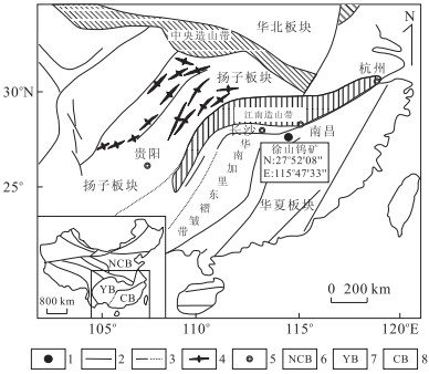
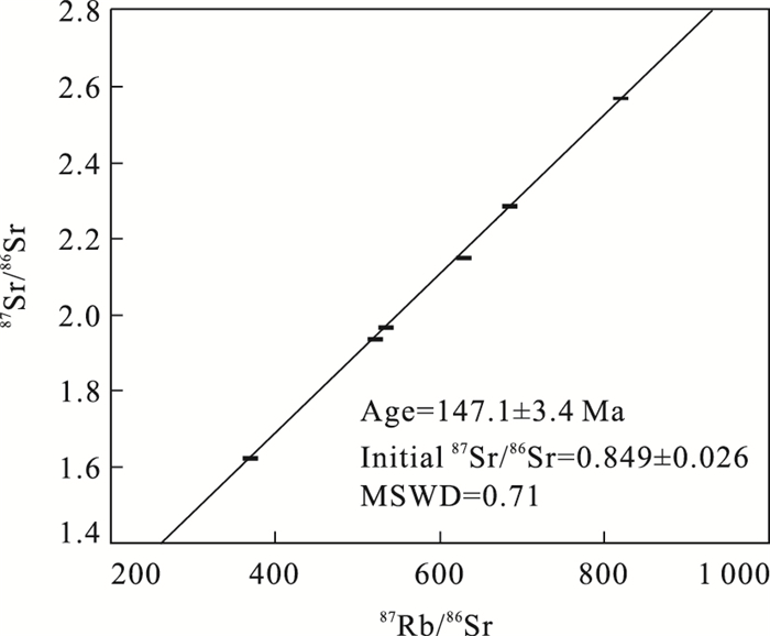
The Xushan tungsten-copper deposit is located in the central part of Jiangxi Province. It is a trinity deposit comprising three types of ore-bodies, i.e. quartz vein type, skarn type, and granite type. Rb-Sr micro-isochron method is first applied to determining the ore-forming age by using single grain of muscovite growing at the edge of the wolframite-quartz vein type tungsten ore. Result shows that the mineralization age is 147.1±3.4 Ma, with MSWD=0.71, and the ISr value is 0.849±0.026. This ore-forming age is similar to those of quartz-wolframite-vein tungsten deposits in southern Jiangxi, but is much later than the ages of copper deposits in northeastern Jiangxi and slightly earlier than the ages of copper deposits in northwestern Jiangxi. The very high ISr value may suggest that the ore-related granite was a melting product of highly evolved and highly saturated crust material, and the ore-forming fluids have extracted the strontium of extremely high 87Sr/86Sr ratios from the granite through water-rock interaction. It also suggests that there was almost no contribution of mantle material during the formation of either ore-related granite or tungsten mineralization.
The Xushan tungsten-copper deposit is located in the central part of Jiangxi Province. It is a trinity deposit comprising three types of ore-bodies, i.e. quartz vein type, skarn type, and granite type. Rb-Sr micro-isochron method is first applied to determining the ore-forming age by using single grain of muscovite growing at the edge of the wolframite-quartz vein type tungsten ore. Result shows that the mineralization age is 147.1±3.4 Ma, with MSWD=0.71, and the ISr value is 0.849±0.026. This ore-forming age is similar to those of quartz-wolframite-vein tungsten deposits in southern Jiangxi, but is much later than the ages of copper deposits in northeastern Jiangxi and slightly earlier than the ages of copper deposits in northwestern Jiangxi. The very high ISr value may suggest that the ore-related granite was a melting product of highly evolved and highly saturated crust material, and the ore-forming fluids have extracted the strontium of extremely high 87Sr/86Sr ratios from the granite through water-rock interaction. It also suggests that there was almost no contribution of mantle material during the formation of either ore-related granite or tungsten mineralization.


2011, 36(2): 289-298.
doi: 10.3799/dqkx.2011.030
Abstract:
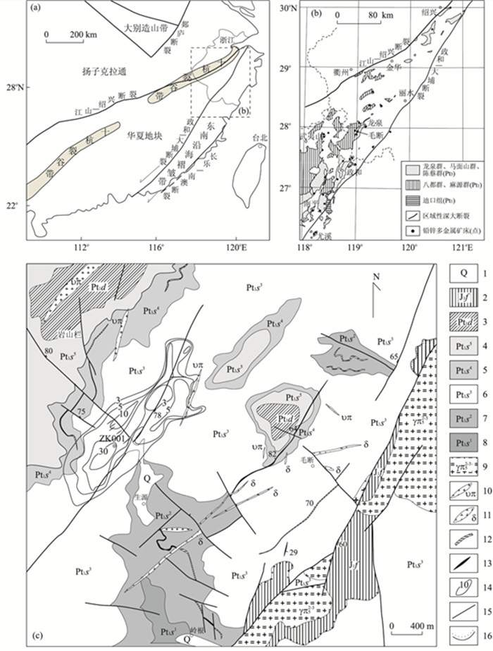
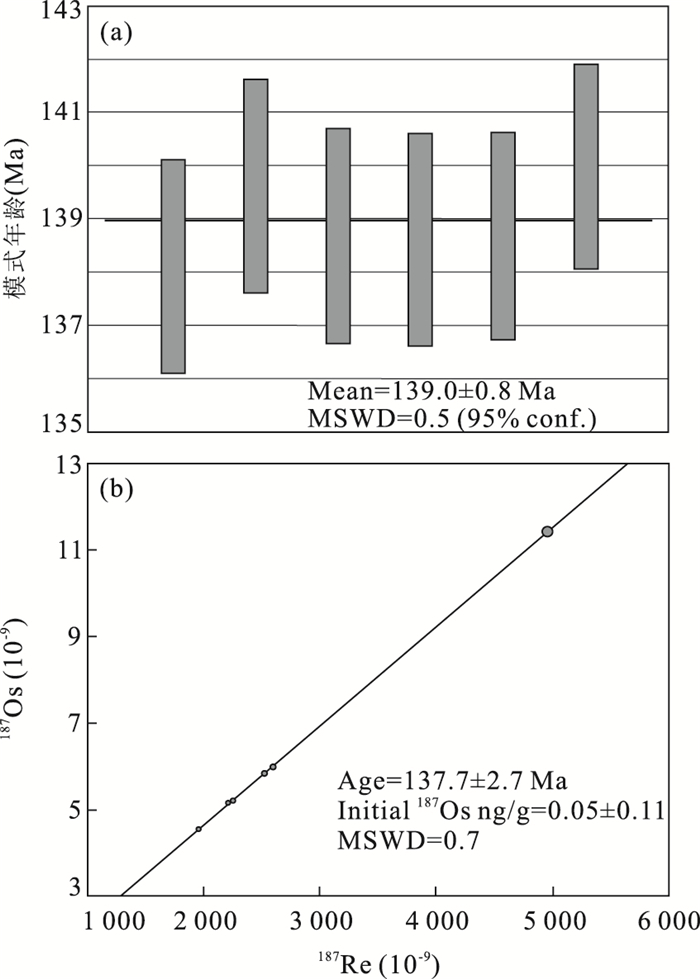
The Maoduan lead-zinc polymetallic deposit, located in uplift area between the Jiangshan-Shaoxing and Zhenghe-Dabu deep faults in southwestern Zhejiang Province, is one of typical lead-zinc polymetallic deposits in this region. Re-Os dating of 5 molybdenite separated from the Maoduan lead-zinc polymetallic deposit gave model ages from 138.6±2.0 Ma to 140.0±1.9 Ma. These data yielded an isochron age of 137.7±2.7 Ma with MSWD=0.7, and a weighted average model age of 139.0±0.8 Ma (MSWD=0.5). This result is in good agreement with the Maoduan concealed monzogranite, indicating that Pb-Zn polymetal mineralization was related to granite crystallization. According to the precise Re-Os ages we have reported and previous studies, we interpret the Maoduan Pb-Zn deposit formed in an extensional setting related to lithospheric extension during the Early Cretaceous in South China. Meanwhile, we also point out that 140±7 Ma may be another important time range of tungsten-molybdenite-lead-zinc polymetallic mineralization in South China.
The Maoduan lead-zinc polymetallic deposit, located in uplift area between the Jiangshan-Shaoxing and Zhenghe-Dabu deep faults in southwestern Zhejiang Province, is one of typical lead-zinc polymetallic deposits in this region. Re-Os dating of 5 molybdenite separated from the Maoduan lead-zinc polymetallic deposit gave model ages from 138.6±2.0 Ma to 140.0±1.9 Ma. These data yielded an isochron age of 137.7±2.7 Ma with MSWD=0.7, and a weighted average model age of 139.0±0.8 Ma (MSWD=0.5). This result is in good agreement with the Maoduan concealed monzogranite, indicating that Pb-Zn polymetal mineralization was related to granite crystallization. According to the precise Re-Os ages we have reported and previous studies, we interpret the Maoduan Pb-Zn deposit formed in an extensional setting related to lithospheric extension during the Early Cretaceous in South China. Meanwhile, we also point out that 140±7 Ma may be another important time range of tungsten-molybdenite-lead-zinc polymetallic mineralization in South China.
2011, 36(2): 299-306.
doi: 10.3799/dqkx.2011.031
Abstract:
This paper summarizes in detail some advances in recent years about the ore-forming tectonic environment of VHMS type, SEDEX type and VSHMS type massive sulfide deposits, on which VHMS type deposit emphasizes three aspects as follows: the spatial and temporal distribution regularities of VHMS type ore deposits which occurred in intra-arc or backarc rift; metallogenic knowledge acquired from contrasting of ancient global VHMS type deposits; summary on the characteristics of lithological types and rock association, and general evolutionary processes of magma from modern seabed hydrothermal areas controlled under trench-island arc-backarc basin tectonic system. SEDEX type deposit emphasizes the metallogenic geodynamic environment from shale-hosted massive sulfide deposits of Proterozoic northeastern Australia. It is different from traditional understandings that these super-large size deposits do not occur in the intra-continental rift or aulocogen tectonic environments, whereas occurred in far-field backarc continental extension basin under plate convergent process, and it is especially pointed out that the paleaozoic typical SEDEX type deposit, such as Sullivan, Red dog, is also regarded as the same metallogenic geodynamic setting as their Proterozoic counterparts. Apart from this, these deposits under the tectonic environment related to convergent plate have more important ore-finding prospect. VSHMS type deposit was concerned much more in the latest ten years, although it has the similar ore ccurrence and metallogenic process as those deposits mentioned above, the different metallogenic tectonic environments, generally occurring in the transition tectonic setting between VHMS type and SEDEX type deposit, making it more important implication for tectonic setting. Accordingly, under convergent plate tectonic setting, from the plate boundary to far-field backarc intra-continental extension basin, a metallogenic sequence was established, i.e, VHMS→VSHMS→SEDEX.
This paper summarizes in detail some advances in recent years about the ore-forming tectonic environment of VHMS type, SEDEX type and VSHMS type massive sulfide deposits, on which VHMS type deposit emphasizes three aspects as follows: the spatial and temporal distribution regularities of VHMS type ore deposits which occurred in intra-arc or backarc rift; metallogenic knowledge acquired from contrasting of ancient global VHMS type deposits; summary on the characteristics of lithological types and rock association, and general evolutionary processes of magma from modern seabed hydrothermal areas controlled under trench-island arc-backarc basin tectonic system. SEDEX type deposit emphasizes the metallogenic geodynamic environment from shale-hosted massive sulfide deposits of Proterozoic northeastern Australia. It is different from traditional understandings that these super-large size deposits do not occur in the intra-continental rift or aulocogen tectonic environments, whereas occurred in far-field backarc continental extension basin under plate convergent process, and it is especially pointed out that the paleaozoic typical SEDEX type deposit, such as Sullivan, Red dog, is also regarded as the same metallogenic geodynamic setting as their Proterozoic counterparts. Apart from this, these deposits under the tectonic environment related to convergent plate have more important ore-finding prospect. VSHMS type deposit was concerned much more in the latest ten years, although it has the similar ore ccurrence and metallogenic process as those deposits mentioned above, the different metallogenic tectonic environments, generally occurring in the transition tectonic setting between VHMS type and SEDEX type deposit, making it more important implication for tectonic setting. Accordingly, under convergent plate tectonic setting, from the plate boundary to far-field backarc intra-continental extension basin, a metallogenic sequence was established, i.e, VHMS→VSHMS→SEDEX.


2011, 36(2): 307-316.
doi: 10.3799/dqkx.2011.032
Abstract:
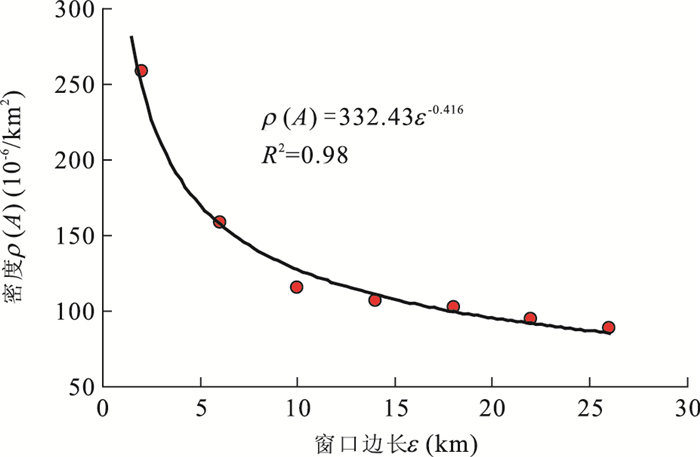
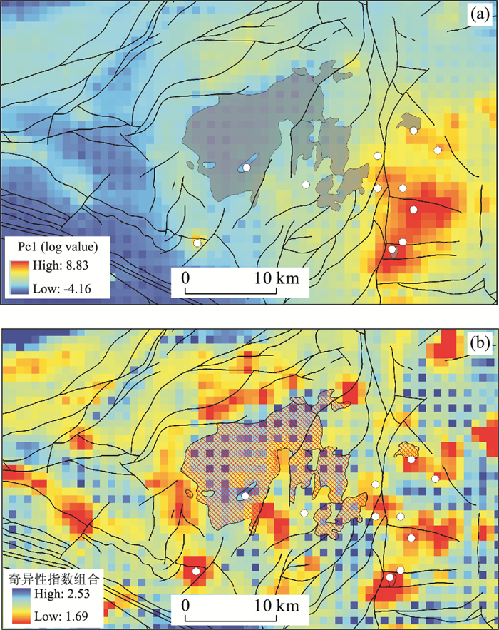
This paper investigates the nonlinear properties of geo-anomalies related to mineralization. It was demonstrated that geochemical anomalies in stream sediments in Gejiu mineral district caused by Sn mineralization can be modeled by fractal and multifractal models and they depict singularity, discontinuity, chaoticality, and indifferentiality. It was also shown that the singularity calculated from 2D geochemical landscape can reflect the causes of buried sources. The concepts and methods were validated using the concentration values of trace elements Sn, Cu, As, Pb, Zn and Cd in stream sediments. The results obtained using windows-based local singularity analysis method not only provide anomalies in general agreement with the locations of known mineral deposits in the eastern Gejiu district but also new anomalies delineated in the other areas of Gejiu that provide potential target areas for further mineral exploration for undiscovered Sn mineral deposits. It is anticipated that the singularity analysis method introduced in the paper will become a new powerful tool applicable for quantitative prediction of buried mineral deposits in covered terrain.
This paper investigates the nonlinear properties of geo-anomalies related to mineralization. It was demonstrated that geochemical anomalies in stream sediments in Gejiu mineral district caused by Sn mineralization can be modeled by fractal and multifractal models and they depict singularity, discontinuity, chaoticality, and indifferentiality. It was also shown that the singularity calculated from 2D geochemical landscape can reflect the causes of buried sources. The concepts and methods were validated using the concentration values of trace elements Sn, Cu, As, Pb, Zn and Cd in stream sediments. The results obtained using windows-based local singularity analysis method not only provide anomalies in general agreement with the locations of known mineral deposits in the eastern Gejiu district but also new anomalies delineated in the other areas of Gejiu that provide potential target areas for further mineral exploration for undiscovered Sn mineral deposits. It is anticipated that the singularity analysis method introduced in the paper will become a new powerful tool applicable for quantitative prediction of buried mineral deposits in covered terrain.


2011, 36(2): 317-326.
doi: 10.3799/dqkx.2011.033
Abstract:
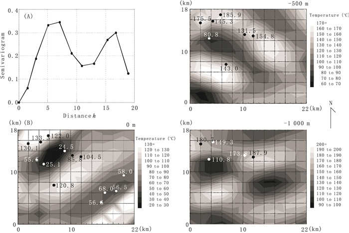
The east Tianshan ore-belt is one of the most important ore concentrated districts of Cu-Au in China. Long and complicated geological evolution created a complex geological background, multi-periods and diversity of mineralization. In this study, stream sediment survey data of Cu-Au are used for spatial distribution analysis, and then Geostatistical method and Spectrum-Area (S-A) method are implemented to obtain ore-forming information at different scale. The research results are as follows: (1) the modeling semivirograms show the max range of Cu and Au are 80 km and 47 km, the direction of max range is along the trend of regional deep faults, which are the major factors controlling the distribution of Cu, Au concentration. Cu concentration exhibits more strong structure character than Au in region. (2) Both low pass filtering in S-A and universal Kringing can obtain the similar ore forming information which reflect the regularity of enrichment of ore-forming elements caused by regional mineralization. (3) Multi-fractal filtering can effectively decompose the concentration data from stream sediment survey in complicated geological setting into different hierarchy, including local anomalies and regional anomalies. Different anomaly filters defined in ln(Spectrum)-ln(Area) plot can be constructed to obtain Cu and Au anomalies at different scale. The local Cu anomalies obtained by S-A method are spatially associated with known Cu deposits, which reveal some conceal ore-forming information in low background. The local anomalies of Au in pinch-and-swell and oriented in North-East trend obtained by S-A method may imply that the gold mineralization is controlled by sub-fault system in NE trend.
The east Tianshan ore-belt is one of the most important ore concentrated districts of Cu-Au in China. Long and complicated geological evolution created a complex geological background, multi-periods and diversity of mineralization. In this study, stream sediment survey data of Cu-Au are used for spatial distribution analysis, and then Geostatistical method and Spectrum-Area (S-A) method are implemented to obtain ore-forming information at different scale. The research results are as follows: (1) the modeling semivirograms show the max range of Cu and Au are 80 km and 47 km, the direction of max range is along the trend of regional deep faults, which are the major factors controlling the distribution of Cu, Au concentration. Cu concentration exhibits more strong structure character than Au in region. (2) Both low pass filtering in S-A and universal Kringing can obtain the similar ore forming information which reflect the regularity of enrichment of ore-forming elements caused by regional mineralization. (3) Multi-fractal filtering can effectively decompose the concentration data from stream sediment survey in complicated geological setting into different hierarchy, including local anomalies and regional anomalies. Different anomaly filters defined in ln(Spectrum)-ln(Area) plot can be constructed to obtain Cu and Au anomalies at different scale. The local Cu anomalies obtained by S-A method are spatially associated with known Cu deposits, which reveal some conceal ore-forming information in low background. The local anomalies of Au in pinch-and-swell and oriented in North-East trend obtained by S-A method may imply that the gold mineralization is controlled by sub-fault system in NE trend.


2011, 36(2): 327-335.
doi: 10.3799/dqkx.2011.034
Abstract:
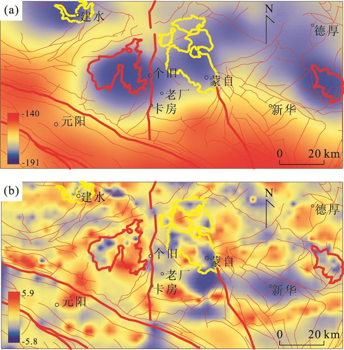
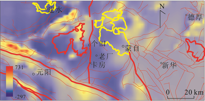
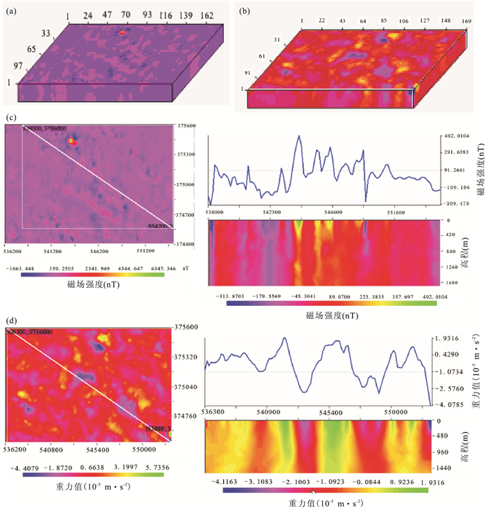
Geological process often experienced a number of causal or complex genetic stages, which often resulted in original gravity and magnetic anomaly composed of various geological elements including background anomaly, and local anomaly which may be caused by deposits, alternation and concealed rocks, etc., which are associated with mineral exploration and prospecting. It is one of the most difficult issues in mineral prospecting and potential resource assessment as how to separate gravity and magnetic anomaly, which is significant for mineral exploration from original composite anomaly. Empirical mode decomposition (EMD) is considered to be an effective method in superimposed information separation. In this paper, a new bidimensional empirical mode decomposition (BEMD) method is proposed, that is, biharmonic spline interpolation (BSI) instead of general spline interpolation for improving stability. As a case study, gravity and magnetic data in Gejiu, Yunnan, China, have been used to extract local anomaly which could reveal potential information in mineral exploration by multiscale and nonlinear decomposition with BEMD method. It extends the application of empirical mode decomposition.
Geological process often experienced a number of causal or complex genetic stages, which often resulted in original gravity and magnetic anomaly composed of various geological elements including background anomaly, and local anomaly which may be caused by deposits, alternation and concealed rocks, etc., which are associated with mineral exploration and prospecting. It is one of the most difficult issues in mineral prospecting and potential resource assessment as how to separate gravity and magnetic anomaly, which is significant for mineral exploration from original composite anomaly. Empirical mode decomposition (EMD) is considered to be an effective method in superimposed information separation. In this paper, a new bidimensional empirical mode decomposition (BEMD) method is proposed, that is, biharmonic spline interpolation (BSI) instead of general spline interpolation for improving stability. As a case study, gravity and magnetic data in Gejiu, Yunnan, China, have been used to extract local anomaly which could reveal potential information in mineral exploration by multiscale and nonlinear decomposition with BEMD method. It extends the application of empirical mode decomposition.


2011, 36(2): 336-340.
doi: 10.3799/dqkx.2011.035
Abstract:
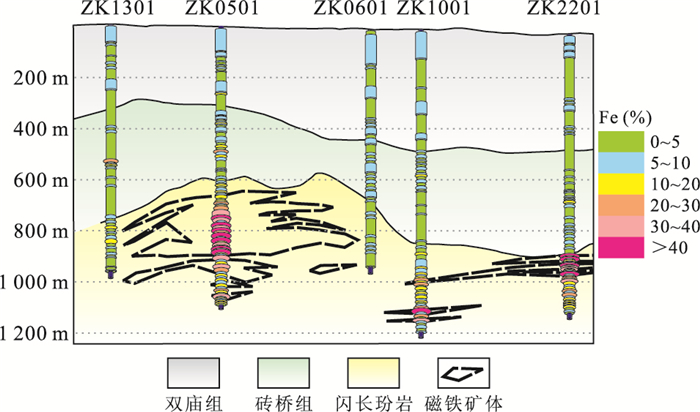
Portable X-ray fluorescence spectrum (PXRF) is a new analysis technique in-situ and is usually applied in both geochemical research at geological outcrop scale and heavy metal pollution assessment in soil. In this study, PXRF was used to recognize lithology section and to analyze the content of Fe, Mn, Cr, Co, Ni, Ti, V, Cu, Zn, Pb, Ag, Mo, K, Ca, As, Sb, Bi, Cs, Zr and Nb along 5 drill holes in the Nihe iron deposit, Anhui, East China. Based on these data, the spatial distribution of these elements is obtained. The results show that (1) the areas with high values of Fe obtained by PXRF have high spatial correlation with the area with high grade of Fe delineated by chemical analysis; (2) Fe anomalies, Fe-V-Mn-Cr-Ni-Ti-Bi anomalies, Zn anomalies and Zn-Cu-Cd anomalies are good indicators for Fe mineralization, Cu and Zn mineralization, respectively; and (3) K and Ca anomalies are good indictors for potash feldspar alteration and anhydrite alteration, respectively. These results indicate that PXRF is a convenient, quick, practical, reliable, and nondestructive technique of low cost for identifying of mineralization and alteration along drill in the field.
Portable X-ray fluorescence spectrum (PXRF) is a new analysis technique in-situ and is usually applied in both geochemical research at geological outcrop scale and heavy metal pollution assessment in soil. In this study, PXRF was used to recognize lithology section and to analyze the content of Fe, Mn, Cr, Co, Ni, Ti, V, Cu, Zn, Pb, Ag, Mo, K, Ca, As, Sb, Bi, Cs, Zr and Nb along 5 drill holes in the Nihe iron deposit, Anhui, East China. Based on these data, the spatial distribution of these elements is obtained. The results show that (1) the areas with high values of Fe obtained by PXRF have high spatial correlation with the area with high grade of Fe delineated by chemical analysis; (2) Fe anomalies, Fe-V-Mn-Cr-Ni-Ti-Bi anomalies, Zn anomalies and Zn-Cu-Cd anomalies are good indicators for Fe mineralization, Cu and Zn mineralization, respectively; and (3) K and Ca anomalies are good indictors for potash feldspar alteration and anhydrite alteration, respectively. These results indicate that PXRF is a convenient, quick, practical, reliable, and nondestructive technique of low cost for identifying of mineralization and alteration along drill in the field.


2011, 36(2): 341-346.
doi: 10.3799/dqkx.2011.036
Abstract:
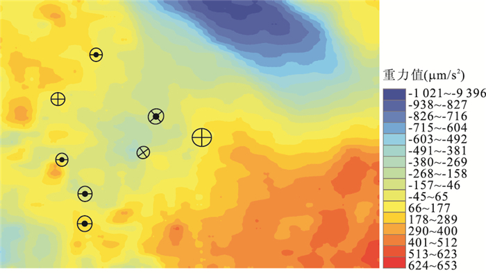
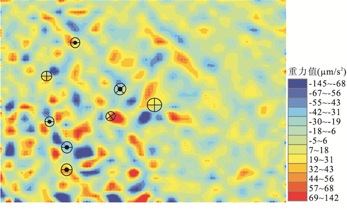
A singular-value decomposition (SVD) program on a MATLAB platform was effectively used to handle gravity signals for the Tongshi gold field. Firstly. The gravity signals are firstly decomposed into different eigenimages with singular-value decomposition method. Secondly, the thresholds between the eigenvalues reflecting different layers of ore-controlling factors are established by multi-fractal method. Finally the eigenvalues with different layers of ore-controlling factors were rebuilt on certain mathematical rules. This yielded three layers of two-dimensional singular-value images that meticulously depict ore-controlling factors in different scales respectively. (1) The regional ore-controlling factor is a saddle valley with the gravity anomaly values varying from -55 to 51 μm/s2 of the NW trending swell with the gravity anomaly values varying from -55 to 567 μm/s2 on the SW side of the Mesozoic volcanic sedimentary basin with the gravity anomaly values varying from -56 to -974 μm/s2. The saddle valley might be tectonically an extensional area where the Tongshi complex pluton and all gold deposits are located and thus this area is a favorable area for gold deposits. (2) The local ore-controlling factor is the Tongshi complex pluton with a negative circular gravity anomaly varying from -339 to -11 μm/s2 and the ring contact metasomatic mineralization zone around the Tongshi complex with the positive gravity anomaly varying from 37 to 345 μm/s2. The porphyry gold occurrences are located within the Tongshi intrusive complex and Skarn iron-copper-gold occurrences are located in the inner contact metasomatic zone between the intrusive complex and its host rocks. Crypto-breccia and Carlin-type gold deposits are located at the outer contact metasomatic zone between the intrusive complex and its host rocks. Thus the two areas are potential areas for gold deposits. (3) The concrete ore-controlling factor is crossing areas between the NE trending faults and NW trending faults reflected by the two trending gravity anomaly zones. Almost all gold deposits are located within crossing areas and thus these areas are prospective areas for gold deposits. (4) The Tongshi gold field has a typical complexity with multi-layers of ore-controlling factors.
A singular-value decomposition (SVD) program on a MATLAB platform was effectively used to handle gravity signals for the Tongshi gold field. Firstly. The gravity signals are firstly decomposed into different eigenimages with singular-value decomposition method. Secondly, the thresholds between the eigenvalues reflecting different layers of ore-controlling factors are established by multi-fractal method. Finally the eigenvalues with different layers of ore-controlling factors were rebuilt on certain mathematical rules. This yielded three layers of two-dimensional singular-value images that meticulously depict ore-controlling factors in different scales respectively. (1) The regional ore-controlling factor is a saddle valley with the gravity anomaly values varying from -55 to 51 μm/s2 of the NW trending swell with the gravity anomaly values varying from -55 to 567 μm/s2 on the SW side of the Mesozoic volcanic sedimentary basin with the gravity anomaly values varying from -56 to -974 μm/s2. The saddle valley might be tectonically an extensional area where the Tongshi complex pluton and all gold deposits are located and thus this area is a favorable area for gold deposits. (2) The local ore-controlling factor is the Tongshi complex pluton with a negative circular gravity anomaly varying from -339 to -11 μm/s2 and the ring contact metasomatic mineralization zone around the Tongshi complex with the positive gravity anomaly varying from 37 to 345 μm/s2. The porphyry gold occurrences are located within the Tongshi intrusive complex and Skarn iron-copper-gold occurrences are located in the inner contact metasomatic zone between the intrusive complex and its host rocks. Crypto-breccia and Carlin-type gold deposits are located at the outer contact metasomatic zone between the intrusive complex and its host rocks. Thus the two areas are potential areas for gold deposits. (3) The concrete ore-controlling factor is crossing areas between the NE trending faults and NW trending faults reflected by the two trending gravity anomaly zones. Almost all gold deposits are located within crossing areas and thus these areas are prospective areas for gold deposits. (4) The Tongshi gold field has a typical complexity with multi-layers of ore-controlling factors.


2011, 36(2): 347-354.
doi: 10.3799/dqkx.2011.037
Abstract:
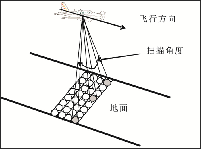
This paper reviews the applications of laser mapping technology in the fields of global glacier analysis and monitoring, local and large scale faults extraction, landslide mapping and susceptibility assessment, shoreline detection and coastal erosion monitoring. As a new type of air-or-space borne remote sensing sensor, the application of laser mapping technology (including spaceborne, airborne, vehicle-based and terrestrial) has been extended from conventional surveying and precision surveying to such various fields as cultural heritage protection. The four application fields reviewed in the paper are four major research topics that are mostly related to human-environmental interaction. The review conclusion shows that the laser mapping technology should be or is becoming an indispensable tool for above mentioned issues.
This paper reviews the applications of laser mapping technology in the fields of global glacier analysis and monitoring, local and large scale faults extraction, landslide mapping and susceptibility assessment, shoreline detection and coastal erosion monitoring. As a new type of air-or-space borne remote sensing sensor, the application of laser mapping technology (including spaceborne, airborne, vehicle-based and terrestrial) has been extended from conventional surveying and precision surveying to such various fields as cultural heritage protection. The four application fields reviewed in the paper are four major research topics that are mostly related to human-environmental interaction. The review conclusion shows that the laser mapping technology should be or is becoming an indispensable tool for above mentioned issues.

2011, 36(2): 355-359.
doi: 10.3799/dqkx.2011.038
Abstract:
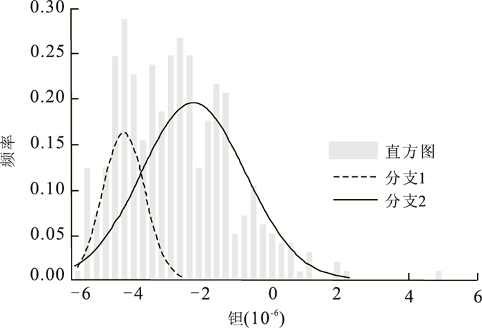
When separating the mixed distributions of element abundance, probability graphs can only make a rough estimate of parameters. To solve this problem, we introduce a method of Minimum Message Length Criterion-Expectation-Maximization Algorithm (MML-EM). Simulation studies have shown that the method has higher accuracy than probability graphs in estimating the parameters of mixed distributions of element abundance. It is applied to dealing with the geochemical data of quartz vein, sampled from tungsten ore in Dajishan, Jiangxi Province. The research shows that the concentrations of W, Ta and Nb are mixed pairs of log-normal distributions, biomodel distributions. Referring to the previous geological results, the conclusion is as follows. For W, the component with high average value represents the high-grade ore formed by hydrothermal filling type in ore-forming processes, and the one with low average value represents the mineralization in other stages, high-value parts of which may indicate that there is a weak disseminated tungsten mineralization at late magmatic stage. For Ta and Nb, the situation is similar. So the method provides a good quantitative tool that can help separate the mixed distributions of geochemical data and explain the multiple geological events.
When separating the mixed distributions of element abundance, probability graphs can only make a rough estimate of parameters. To solve this problem, we introduce a method of Minimum Message Length Criterion-Expectation-Maximization Algorithm (MML-EM). Simulation studies have shown that the method has higher accuracy than probability graphs in estimating the parameters of mixed distributions of element abundance. It is applied to dealing with the geochemical data of quartz vein, sampled from tungsten ore in Dajishan, Jiangxi Province. The research shows that the concentrations of W, Ta and Nb are mixed pairs of log-normal distributions, biomodel distributions. Referring to the previous geological results, the conclusion is as follows. For W, the component with high average value represents the high-grade ore formed by hydrothermal filling type in ore-forming processes, and the one with low average value represents the mineralization in other stages, high-value parts of which may indicate that there is a weak disseminated tungsten mineralization at late magmatic stage. For Ta and Nb, the situation is similar. So the method provides a good quantitative tool that can help separate the mixed distributions of geochemical data and explain the multiple geological events.


2011, 36(2): 360-366.
doi: 10.3799/dqkx.2011.039
Abstract:
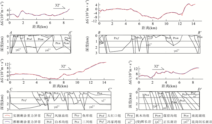
3D geological modeling is an important method and frontier of mineral resources exploration and assessment in the world. In this paper, a case study of the Luanchuan molybdenum polymetallic ore belt which has complicated geological setting and diversity metallogenic condition of geology, 3D geological modeling is combined geological knowledge with gravity and magnetic data integration. The research contents, methods, and results are summarized as the following aspects: (1) based on the geological setting and metallogenic conditions to determine the deposit characteristics of the study area and the near-surface geological object features of the spatial properties; (2) on basis of geological information in the qualitative interpretation using gravity and magnetic data, 2.5D forward interpretation and 3D imaging method of potential field inversion and interpretation of the probability of deep geological objects; (3) combination geological data with gravity and magnetic inversion datas to determine the space-time-genesis relationship among the Late Jurassic porphyry rock, ore, and ore mineralization favorable geological structures. The research results show that combination the geological characteristics including rock properties with inversion of gravity and magnetic interpretation to define geological object geometries, which is beneficial for geological prospecting, delineation of the quantitative evaluation of prospecting targets.
3D geological modeling is an important method and frontier of mineral resources exploration and assessment in the world. In this paper, a case study of the Luanchuan molybdenum polymetallic ore belt which has complicated geological setting and diversity metallogenic condition of geology, 3D geological modeling is combined geological knowledge with gravity and magnetic data integration. The research contents, methods, and results are summarized as the following aspects: (1) based on the geological setting and metallogenic conditions to determine the deposit characteristics of the study area and the near-surface geological object features of the spatial properties; (2) on basis of geological information in the qualitative interpretation using gravity and magnetic data, 2.5D forward interpretation and 3D imaging method of potential field inversion and interpretation of the probability of deep geological objects; (3) combination geological data with gravity and magnetic inversion datas to determine the space-time-genesis relationship among the Late Jurassic porphyry rock, ore, and ore mineralization favorable geological structures. The research results show that combination the geological characteristics including rock properties with inversion of gravity and magnetic interpretation to define geological object geometries, which is beneficial for geological prospecting, delineation of the quantitative evaluation of prospecting targets.

2011, 36(2): 367-374.
doi: 10.3799/dqkx.2011.040
Abstract:
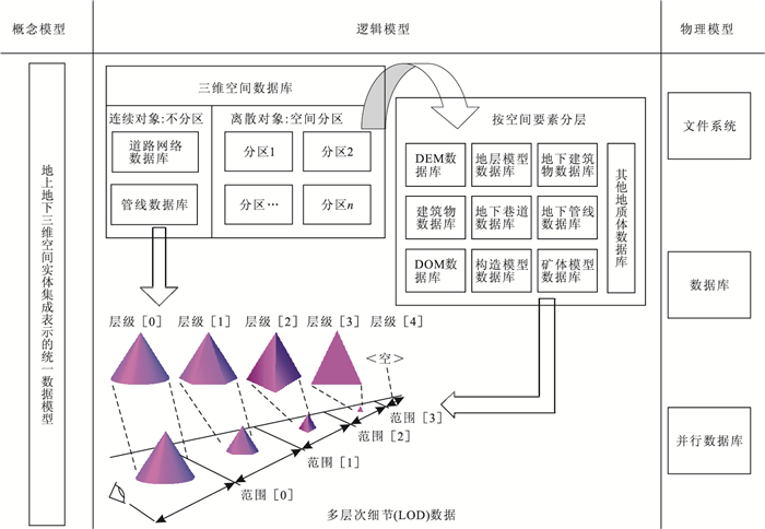
In the application of large scale aboveground and underground entity 3D modeling and spatial analysis, it is a key issue as how to realize integrated organization and management of massive 3D spatial data efficiently due to the diversity and unbalanced distribution of 3D models. A 3D spatial database model considering spatial and semantic relationships is proposed to solve this problem and corresponding concept model, logical model and physical model are also presented. Especially aiming at the complexity of geological bodies, the multi-scale underground spatial object concept model considering semantic and multi-level 3D spatial index mechanism is put forward. The prototype 3D spatial database management system has been applied in managing and processing 3D digital city model data of Wuhan and Nanjing. The result shows the validity of the proposed 3D spatial database model.
In the application of large scale aboveground and underground entity 3D modeling and spatial analysis, it is a key issue as how to realize integrated organization and management of massive 3D spatial data efficiently due to the diversity and unbalanced distribution of 3D models. A 3D spatial database model considering spatial and semantic relationships is proposed to solve this problem and corresponding concept model, logical model and physical model are also presented. Especially aiming at the complexity of geological bodies, the multi-scale underground spatial object concept model considering semantic and multi-level 3D spatial index mechanism is put forward. The prototype 3D spatial database management system has been applied in managing and processing 3D digital city model data of Wuhan and Nanjing. The result shows the validity of the proposed 3D spatial database model.


2011, 36(2): 375-380.
doi: 10.3799/dqkx.2011.041
Abstract:
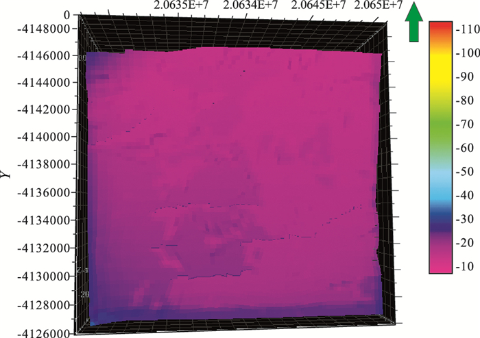
Analysis of the tectonic stress field plays an important role in petroleum accumulation dynamics simulation. The current study on stress field is mainly focused on two-dimensional analysis of plane. With development of the three-dimensional simulation of petroleum forming process, three-dimensional numerical simulation of stress field becomes increasingly important. In this paper, the finite element simulation of stress field and solution of the whole process, based on three-dimensional space, are discussed. After analysis and study of finite element method, the calculation method, based on irregular hexahedral element described by the corner-point grid data model, is put forward in the paper. The three-dimensional finite element method of tectonic stress field, based on irregular corner-point grid data model, is the innovation of this paper.Finally, the above method is used in actual three-dimensional stress field simulation calculation in Dongying depression-Niuzhuang Wangjiagang region. The results, compared to other data models, are more realistic.
Analysis of the tectonic stress field plays an important role in petroleum accumulation dynamics simulation. The current study on stress field is mainly focused on two-dimensional analysis of plane. With development of the three-dimensional simulation of petroleum forming process, three-dimensional numerical simulation of stress field becomes increasingly important. In this paper, the finite element simulation of stress field and solution of the whole process, based on three-dimensional space, are discussed. After analysis and study of finite element method, the calculation method, based on irregular hexahedral element described by the corner-point grid data model, is put forward in the paper. The three-dimensional finite element method of tectonic stress field, based on irregular corner-point grid data model, is the innovation of this paper.Finally, the above method is used in actual three-dimensional stress field simulation calculation in Dongying depression-Niuzhuang Wangjiagang region. The results, compared to other data models, are more realistic.


2011, 36(2): 381-385.
doi: 10.3799/dqkx.2011.042
Abstract:
The curve vector data are characterized by small differences between coordinate values of adjacent points. So in this paper, differences between the coordinate values are converted to the integer offset and then the offset is used as the substitute for coordinates of vector data. The integer offset sequence is processed by integer wavelet transform and then lossless entropy coding is used to compress the wavelet coefficients. Compressing the China's digital geographic map data of SHP files by the presented method generates a compression ratio higher than 11. Experimental results show that, for the vector data lossless compression, the presented compression method can achieve a higher compression ratio than other similar methods.
The curve vector data are characterized by small differences between coordinate values of adjacent points. So in this paper, differences between the coordinate values are converted to the integer offset and then the offset is used as the substitute for coordinates of vector data. The integer offset sequence is processed by integer wavelet transform and then lossless entropy coding is used to compress the wavelet coefficients. Compressing the China's digital geographic map data of SHP files by the presented method generates a compression ratio higher than 11. Experimental results show that, for the vector data lossless compression, the presented compression method can achieve a higher compression ratio than other similar methods.


2011, 36(2): 386-392.
doi: 10.3799/dqkx.2011.043
Abstract:
Glacial-interglacial change in terrestrial carbon pools is an unknown issue in paleo-carbon cycle research. Carbon flux between carbon pools in different time scales has been studied from marine isotope, model simulating and paleo-environmental evidence by many scientists. Any tiny fluctuation of soil carbon pool with vast carbon reserves would affect ecosystem more easily than other terrestrial carbon pools and atmospheric CO2 concentration, and in turn impacted global climate finally. In this paper, the evolution of carbon density of soil organic matter (SOCD) in south of Chinese loess plateau over the past 40 ka was studied. It was found that SOCD in MIS-3 was more intensive than magnetic susceptibility in the details to explain tiny fluctuations. SOCD increased rapidly and fluctuated several times in high level in MIS-3. It may be because climate in this period was more suitable for soil organic carbon's accumulation and preservation in loess and paleosoil. In the last glacial maximum (LGM), SOCD decreased sharply as climate rapidly fluctuated. During the period, there was a climatic and SOCD rebounding event that lasted for about 2 ka and the minimum SOCD value occurred at ~14 ka BP and ~19 ka BP. Compared with the marine oxygen isotope, the trends of soil organic carbon pool in LGM and Holocene were similar. The magnetic susceptibility began to increase at 15 ka, and the increase seemed to be prior to SOCD and marine oxygen isotope. At the early time of Holocene, SOCD increased gradually and then decreased, and the maximum was at about 7-5 ka BP.
Glacial-interglacial change in terrestrial carbon pools is an unknown issue in paleo-carbon cycle research. Carbon flux between carbon pools in different time scales has been studied from marine isotope, model simulating and paleo-environmental evidence by many scientists. Any tiny fluctuation of soil carbon pool with vast carbon reserves would affect ecosystem more easily than other terrestrial carbon pools and atmospheric CO2 concentration, and in turn impacted global climate finally. In this paper, the evolution of carbon density of soil organic matter (SOCD) in south of Chinese loess plateau over the past 40 ka was studied. It was found that SOCD in MIS-3 was more intensive than magnetic susceptibility in the details to explain tiny fluctuations. SOCD increased rapidly and fluctuated several times in high level in MIS-3. It may be because climate in this period was more suitable for soil organic carbon's accumulation and preservation in loess and paleosoil. In the last glacial maximum (LGM), SOCD decreased sharply as climate rapidly fluctuated. During the period, there was a climatic and SOCD rebounding event that lasted for about 2 ka and the minimum SOCD value occurred at ~14 ka BP and ~19 ka BP. Compared with the marine oxygen isotope, the trends of soil organic carbon pool in LGM and Holocene were similar. The magnetic susceptibility began to increase at 15 ka, and the increase seemed to be prior to SOCD and marine oxygen isotope. At the early time of Holocene, SOCD increased gradually and then decreased, and the maximum was at about 7-5 ka BP.


