2011 Vol. 36, No. 4
Display Method:
2011, 36(4): 370-678.
doi: 10.3799/dqkx.2011.068
 PDF 2679KB
Abstract:
Alpine glacier and snow can record signals of surface earth. From September 2002 to October 2005, Surface snow samples were collected on Urumqi glacier No.1 and chemical characteristics and seasonal variations of major ions, dust, and metal were measured. Results show that the concentration of major ions is Ca2+ > SO42- > NO3- > Cl- > NH4+ > Mg2+ > Na+ > K+, Ca2+ is the dominant cation, SO42- is the dominant anion. All ions have good correlation except NO3-. δ18O shows minus correlation with air temperature change. Dust and major ionic concentrations in the snow show obvious seasonal change trend, with higher concentrations in spring but lower ones in summer, which indicates the chemical input of dust activities to snow. Temporal changes of heavy metal (Cd, Pb, Zn, Al, Fe) indicate that human activities also have effect on the snow chemistry.
Alpine glacier and snow can record signals of surface earth. From September 2002 to October 2005, Surface snow samples were collected on Urumqi glacier No.1 and chemical characteristics and seasonal variations of major ions, dust, and metal were measured. Results show that the concentration of major ions is Ca2+ > SO42- > NO3- > Cl- > NH4+ > Mg2+ > Na+ > K+, Ca2+ is the dominant cation, SO42- is the dominant anion. All ions have good correlation except NO3-. δ18O shows minus correlation with air temperature change. Dust and major ionic concentrations in the snow show obvious seasonal change trend, with higher concentrations in spring but lower ones in summer, which indicates the chemical input of dust activities to snow. Temporal changes of heavy metal (Cd, Pb, Zn, Al, Fe) indicate that human activities also have effect on the snow chemistry.


2011, 36(4): 599-609.
doi: 10.3799/dqkx.2011.062
Abstract:
Quantitatively analyzed planktonic foraminiferal data of core A7 were used to discuss the paleoenvironmental changes in the middle Okinawa Trough during the past 18 000 years. The planktonic foraminiferal fauna shows apparent changes corresponding well to the deglaciation-Holocene phases: At about 18-15 ka, the fauna was dominated by cold water species such as Neogloboquadrina dutertrei and Neogloboquadrina pachyderma; Cold water species decreased rapidly between 15-9.4 ka; After 9.4 ka the fauna was dominated by warm water species such as Pulleniatina obliquiloculata, Globigerinoides ruber and Globigerina glutinata. Millennial-scale climate changes during the last deglaciation such as Heinrich 1 (H1), Bølling-Allerød (B/A) and Younger Dryas (YD) were also recorded by planktonic foraminiferal changes, it also shows a series of cold events (at about 2.3-4.6, 5.3, 6.2, 7.3, 8.2 ka) superimposed on a Holocene warming trend. At about 9.4 ka, a sudden change in the relative abundance of warm to cold planktonic foraminiferal species probably indicates a sudden strengthening of the Kuroshio Current in the Okinawa Trough. Five foraminiferal transfer functions were used to estimate the paleo sea-surface temperature (SST) in core A7, through comparisons with SST estimates from two independent methods (U37k' and Mg/Ca-based SST), and the reliability of different foraminiferal transfer functions were evaluated. Our results suggest that SIMMAX doesn't show apparent deglaciation-Holocene SST changes. The other two transfer functions (MAT and RAM), which are also based on modern analog techniques as SIMMAX, both show small SST variations after 13 ka, without any indication of decreased SST during the YD period. Transfer functions FP-12E and IKM-Chen based on Imbrie-Kipp method, show general deglaciation-Holocene SST trends similar to U37k' and Mg/Ca-based SST, however, the deglacial warming is about 1 ka later than the B/A warming, and with no apparent SST decreases during the YD period. We find out that the abnormal SST estimated by FP-12E and IKM-Chen during the last deglaciation were probably caused by Globigerina bulloides, the relative abundance of which was probably controlled by productivity during that period. Through getting rid of the productivity effect of G. bulloides in FP-12E and IKM-Chen, the two modified transfer functions provide SST estimates comparable to the U37k' and Mg/Ca-based SST. Therefore, we concluded that the modified foraminiferal transfer functions of FP-12E and IKM-Chen are more suitable for paleo-SST estimates in the middle Okinawa Trough.
Quantitatively analyzed planktonic foraminiferal data of core A7 were used to discuss the paleoenvironmental changes in the middle Okinawa Trough during the past 18 000 years. The planktonic foraminiferal fauna shows apparent changes corresponding well to the deglaciation-Holocene phases: At about 18-15 ka, the fauna was dominated by cold water species such as Neogloboquadrina dutertrei and Neogloboquadrina pachyderma; Cold water species decreased rapidly between 15-9.4 ka; After 9.4 ka the fauna was dominated by warm water species such as Pulleniatina obliquiloculata, Globigerinoides ruber and Globigerina glutinata. Millennial-scale climate changes during the last deglaciation such as Heinrich 1 (H1), Bølling-Allerød (B/A) and Younger Dryas (YD) were also recorded by planktonic foraminiferal changes, it also shows a series of cold events (at about 2.3-4.6, 5.3, 6.2, 7.3, 8.2 ka) superimposed on a Holocene warming trend. At about 9.4 ka, a sudden change in the relative abundance of warm to cold planktonic foraminiferal species probably indicates a sudden strengthening of the Kuroshio Current in the Okinawa Trough. Five foraminiferal transfer functions were used to estimate the paleo sea-surface temperature (SST) in core A7, through comparisons with SST estimates from two independent methods (U37k' and Mg/Ca-based SST), and the reliability of different foraminiferal transfer functions were evaluated. Our results suggest that SIMMAX doesn't show apparent deglaciation-Holocene SST changes. The other two transfer functions (MAT and RAM), which are also based on modern analog techniques as SIMMAX, both show small SST variations after 13 ka, without any indication of decreased SST during the YD period. Transfer functions FP-12E and IKM-Chen based on Imbrie-Kipp method, show general deglaciation-Holocene SST trends similar to U37k' and Mg/Ca-based SST, however, the deglacial warming is about 1 ka later than the B/A warming, and with no apparent SST decreases during the YD period. We find out that the abnormal SST estimated by FP-12E and IKM-Chen during the last deglaciation were probably caused by Globigerina bulloides, the relative abundance of which was probably controlled by productivity during that period. Through getting rid of the productivity effect of G. bulloides in FP-12E and IKM-Chen, the two modified transfer functions provide SST estimates comparable to the U37k' and Mg/Ca-based SST. Therefore, we concluded that the modified foraminiferal transfer functions of FP-12E and IKM-Chen are more suitable for paleo-SST estimates in the middle Okinawa Trough.


2011, 36(4): 610-620.
doi: 10.3799/dqkx.2011.063
Abstract:
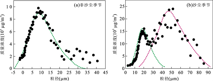
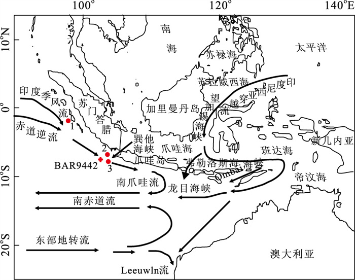
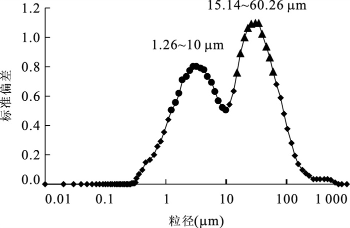
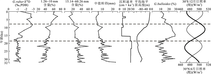
Core BAR9442 (6°04.56′S and 102°25.08′E; 2 542 m water depth) is obtained below the present South Java Current, offshore the southern portion of Sumatra in the eastern Indian Ocean. Based on analyses of δ18O, AMS14C ages, grain-size distribution of standard deviation stages and relative abundance of Globigerina bulloides which commonly encountered in upwelling areas, as well as the record of clay mineral in Gingele et al.(2002), we come to the following conclusion: during the last glacial period 30-17 kaBP, when sea level was lower, terrigenous sands supply increased. Even the austral summer insulations strengthened, though the southward shift of the ITCZ in the austral summer may have been considerably restricted, where the northwest monsoon did not operate, and this would create a situation analogous to the southeast monsoon operating throughout the year, because the trade winds would blow continually across the study area. The climate was cold and dry. Under the influence of Indian northeastern monsoon, the percentage content of illite was the highest, and upwelling activity was absent and induced a low productivity. Rapid rise of sea level at the deglaciation 17-8 kaBP, the shallow connections re-opened, Makassar Strait and Lombok Strait were wider, leading to intensified surface ITF, and clay mineral became the dominated terrigenous material. The SE monsoon and NW monsoon seem to be strengthened in Early Holocene, indicating that the biannual monsoonal system was mostly intense at this time. During the Holocene (about 8 kaBP), with the sea level rising, the throughflow enhanced, and the clay minerals of the terrigenous sediments have a maximum influx while intensified NW monsoon generated a warm and wet climate.
Core BAR9442 (6°04.56′S and 102°25.08′E; 2 542 m water depth) is obtained below the present South Java Current, offshore the southern portion of Sumatra in the eastern Indian Ocean. Based on analyses of δ18O, AMS14C ages, grain-size distribution of standard deviation stages and relative abundance of Globigerina bulloides which commonly encountered in upwelling areas, as well as the record of clay mineral in Gingele et al.(2002), we come to the following conclusion: during the last glacial period 30-17 kaBP, when sea level was lower, terrigenous sands supply increased. Even the austral summer insulations strengthened, though the southward shift of the ITCZ in the austral summer may have been considerably restricted, where the northwest monsoon did not operate, and this would create a situation analogous to the southeast monsoon operating throughout the year, because the trade winds would blow continually across the study area. The climate was cold and dry. Under the influence of Indian northeastern monsoon, the percentage content of illite was the highest, and upwelling activity was absent and induced a low productivity. Rapid rise of sea level at the deglaciation 17-8 kaBP, the shallow connections re-opened, Makassar Strait and Lombok Strait were wider, leading to intensified surface ITF, and clay mineral became the dominated terrigenous material. The SE monsoon and NW monsoon seem to be strengthened in Early Holocene, indicating that the biannual monsoonal system was mostly intense at this time. During the Holocene (about 8 kaBP), with the sea level rising, the throughflow enhanced, and the clay minerals of the terrigenous sediments have a maximum influx while intensified NW monsoon generated a warm and wet climate.


2011, 36(4): 621-634.
doi: 10.3799/dqkx.2011.064
Abstract:
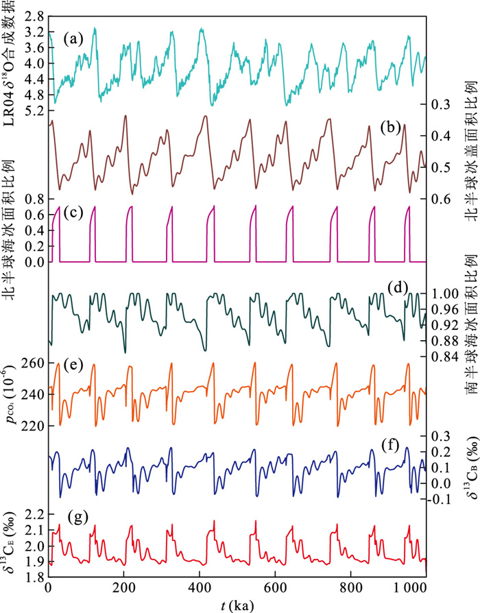
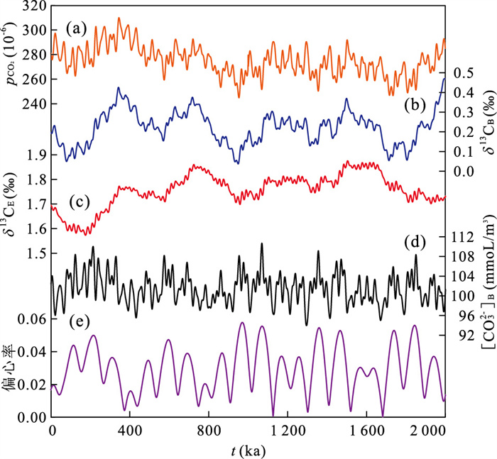
The widely discovered 400-kyr cycles of foraminiferal carbon isotopes (δ13C) from world oceans are interpreted to be linked to the forcing of Earth's eccentricity around the Sun. During the past 1.6 million years (Ma), however, this period extended to 500-kyr and the δ13C maxima of the carbon cycle didn't correspond to the eccentricity's minima. The origin of the 400-kyr cycle and the mechanism for its obscuring during the Pleistocene are elusive. Here we develop a 9-box biogeochemical model on the purpose of understanding interactions between tropical process and variability of ice sheet and their influences on oceanic carbon cycle. The simulated results show that deglaciation is concurrent with the appearance of sea ice in the northern high latitude; while when the northern high latitude is free of sea ice, the ice sheet begins to build up. The simulated building of ice sheet is slower than its retreat, thus the variability of ice sheet is asymmetric. The model can simulate asymmetric 100-kyr cycle of ice sheet under only seasonal solar insolation rather than Milankovitch forcing. By adding the summer insolation of northern high latitude into the ablation term of the ice sheet, precession components become stronger in simulated results. The onset of deglaciation is nonlinearly phase locked to the summer insolation forcing, which leads to a good comparison with geological record. The simulated concentration of atmospheric CO2 is becoming higher during deglaciation owing to the insulation effect of sea ice and is becoming lower during the decrease of ocean circulation. If the model is forced by only tropical weathering process but without the variability of ice sheet, simulated δ13C results exhibit strong 400-kyr cycles indicating a significant response of ocean carbon reservoir to tropical forcing. If the model is forced by both the variability of weathering and ice sheet, however, simulated δ13C results show weaker 400-kyr but stronger 100-kyr cycles and the phase difference between the simulated δ13C and the eccentricity at the 400-kyr band is also different from that in the simulation forced by only weathering process. Our model results seem to indicate that when ice sheet is introduced into the earth system it will result in oceanic circulation reorganization which can suppress the signal of tropical process in ocean carbon reservoir.
The widely discovered 400-kyr cycles of foraminiferal carbon isotopes (δ13C) from world oceans are interpreted to be linked to the forcing of Earth's eccentricity around the Sun. During the past 1.6 million years (Ma), however, this period extended to 500-kyr and the δ13C maxima of the carbon cycle didn't correspond to the eccentricity's minima. The origin of the 400-kyr cycle and the mechanism for its obscuring during the Pleistocene are elusive. Here we develop a 9-box biogeochemical model on the purpose of understanding interactions between tropical process and variability of ice sheet and their influences on oceanic carbon cycle. The simulated results show that deglaciation is concurrent with the appearance of sea ice in the northern high latitude; while when the northern high latitude is free of sea ice, the ice sheet begins to build up. The simulated building of ice sheet is slower than its retreat, thus the variability of ice sheet is asymmetric. The model can simulate asymmetric 100-kyr cycle of ice sheet under only seasonal solar insolation rather than Milankovitch forcing. By adding the summer insolation of northern high latitude into the ablation term of the ice sheet, precession components become stronger in simulated results. The onset of deglaciation is nonlinearly phase locked to the summer insolation forcing, which leads to a good comparison with geological record. The simulated concentration of atmospheric CO2 is becoming higher during deglaciation owing to the insulation effect of sea ice and is becoming lower during the decrease of ocean circulation. If the model is forced by only tropical weathering process but without the variability of ice sheet, simulated δ13C results exhibit strong 400-kyr cycles indicating a significant response of ocean carbon reservoir to tropical forcing. If the model is forced by both the variability of weathering and ice sheet, however, simulated δ13C results show weaker 400-kyr but stronger 100-kyr cycles and the phase difference between the simulated δ13C and the eccentricity at the 400-kyr band is also different from that in the simulation forced by only weathering process. Our model results seem to indicate that when ice sheet is introduced into the earth system it will result in oceanic circulation reorganization which can suppress the signal of tropical process in ocean carbon reservoir.


2011, 36(4): 635-642.
doi: 10.3799/dqkx.2011.065
Abstract:
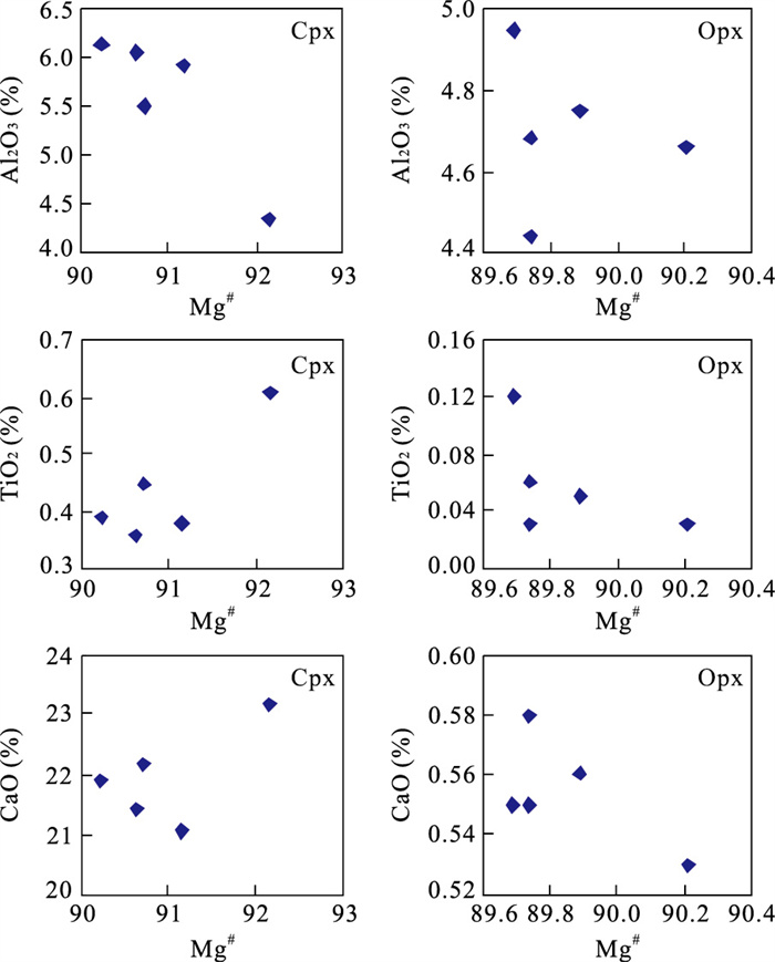
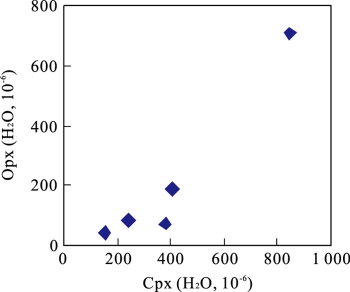
The analysis of infrared spectrum of pyroxene in lherzolite from peridotite xenoliths in Niutoushan, Longhai, Fujian, shows that there is water hosted in the pyroxene which exists by OH hydroxyl. The water content of clinopyroxene is (151-845)×10-6, of orthopyroxene is (40-710)×10-6, and of the whole rock (25-90)×10-6 respectively. The water contents, both of pyroxene and of the whole rock, are higher than those in Nühan, Hannuoba and Subei basin, but are almost the same as those in Yangyuan. It demonstrates that pyroxene is the important reservoir in the upper mantle in Niutoushan. It may have experienced oceanic crust subduction and underplating in investigation locality.
The analysis of infrared spectrum of pyroxene in lherzolite from peridotite xenoliths in Niutoushan, Longhai, Fujian, shows that there is water hosted in the pyroxene which exists by OH hydroxyl. The water content of clinopyroxene is (151-845)×10-6, of orthopyroxene is (40-710)×10-6, and of the whole rock (25-90)×10-6 respectively. The water contents, both of pyroxene and of the whole rock, are higher than those in Nühan, Hannuoba and Subei basin, but are almost the same as those in Yangyuan. It demonstrates that pyroxene is the important reservoir in the upper mantle in Niutoushan. It may have experienced oceanic crust subduction and underplating in investigation locality.

2011, 36(4): 643-658.
doi: 10.3799/dqkx.2011.066
Abstract:
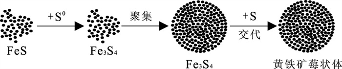
Pyrite framboid, the wonderful microcrystalline (0.1-1 μm) mineral aggregate (5-50 μm), has been a study focus in different disciplines since scientists first discovered (1923) and named it (1935). This paper reviews the progresses and existing problems of pyrite framboid's studies during different study stages including the biogenesis' theory stage (1923-1969), abiogenesis' theory stage (1969-2000) and multiple genesis's theory stage (2000-present) in terms of formation mechanism and the relationship with the environments. It also explores the prospects of pyrite framboid' study, pointing out that pyrite framboid has a great potential as the indicator of the surface and deep biospheres, the extraterrestrial environments and life; and finally puts forward the proposal that we should further the study of pyrite framboid by integrating its studies in that of earth science, life science, materials science, chemistry, nanotechnology and condensed matter physics.
Pyrite framboid, the wonderful microcrystalline (0.1-1 μm) mineral aggregate (5-50 μm), has been a study focus in different disciplines since scientists first discovered (1923) and named it (1935). This paper reviews the progresses and existing problems of pyrite framboid's studies during different study stages including the biogenesis' theory stage (1923-1969), abiogenesis' theory stage (1969-2000) and multiple genesis's theory stage (2000-present) in terms of formation mechanism and the relationship with the environments. It also explores the prospects of pyrite framboid' study, pointing out that pyrite framboid has a great potential as the indicator of the surface and deep biospheres, the extraterrestrial environments and life; and finally puts forward the proposal that we should further the study of pyrite framboid by integrating its studies in that of earth science, life science, materials science, chemistry, nanotechnology and condensed matter physics.


2011, 36(4): 659-669.
doi: 10.3799/dqkx.2011.067
Abstract:
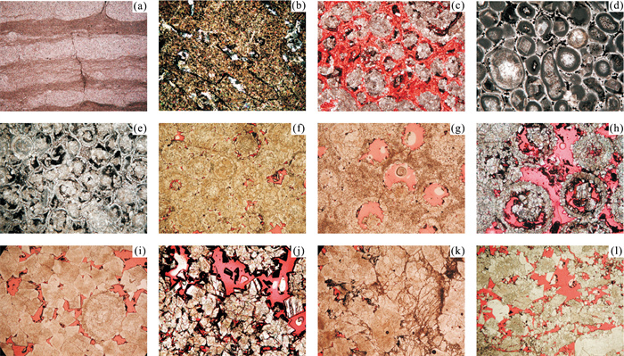
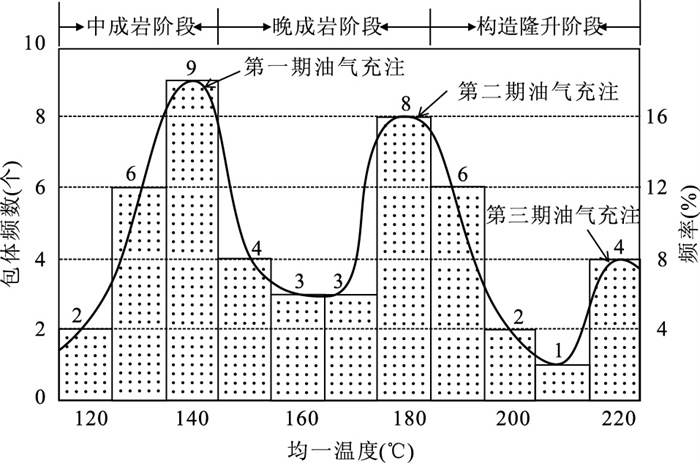
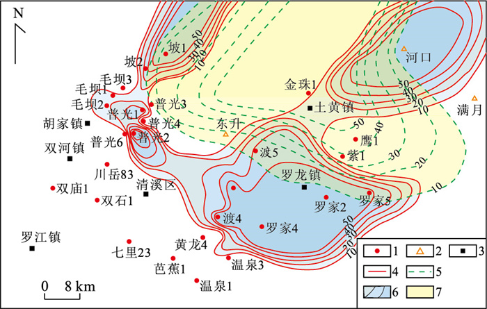
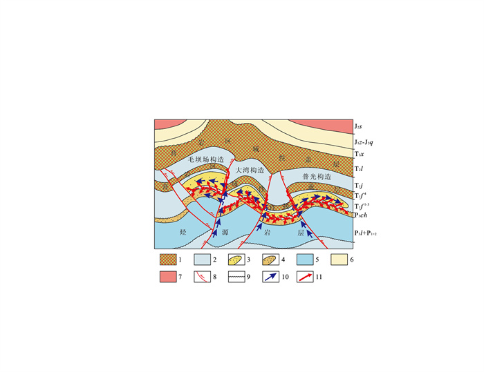
Through the comprehensive study of the texture-genetic classification, diagenetic manners and evolution stages, trace element characteristics of Fe, Mn, Sr, and isotopic geochemistry characteristics of C, O and Sr of Feixianguan Formation, Lower Triassic in Northeast Sichuan, four diagenetic systems were divided in the dolostone of Feixianguan Formation according to "hydrological system", which were pore brine of the penecontemporaneous stage, compaction hot brine of the early and middle diagenetic stages. The character and source of dolomitic fluids of various diagenetic stages and system had certain familiarity and inheritance features of development and evolution, but the interaction process between fluid and rock, diagenetic manners and characteristics of product and assemblage were different respectively. So the diagenetic systems and manner of diagenesis, which are related to the reservoir development closely, are mainly the burial dolomitization and dissolution of multiple-stage. According to the temporal-spatial accordance and matching relations of reservoirs and oil-gas accumulations in different diagenesis systems, four controlling factors of high-quality dolomite reservoirs were concluded: (1) the regional distribution and size of reservoirs were controlled by oolitic shoal microfacies; (2) high-quality reservoirs were based on the burial dolomitization of early and middle diagenetic stages; (3) the distribution of reservoirs was expanded and their quality was improved by burial dolomitization of the late diagenetic stage; (4) tectonic disruption, TSR and dissolution were the key to forming highly-efficient oolitic shoal gas reservoir which contained acid gas rich in H2S and CO2.
Through the comprehensive study of the texture-genetic classification, diagenetic manners and evolution stages, trace element characteristics of Fe, Mn, Sr, and isotopic geochemistry characteristics of C, O and Sr of Feixianguan Formation, Lower Triassic in Northeast Sichuan, four diagenetic systems were divided in the dolostone of Feixianguan Formation according to "hydrological system", which were pore brine of the penecontemporaneous stage, compaction hot brine of the early and middle diagenetic stages. The character and source of dolomitic fluids of various diagenetic stages and system had certain familiarity and inheritance features of development and evolution, but the interaction process between fluid and rock, diagenetic manners and characteristics of product and assemblage were different respectively. So the diagenetic systems and manner of diagenesis, which are related to the reservoir development closely, are mainly the burial dolomitization and dissolution of multiple-stage. According to the temporal-spatial accordance and matching relations of reservoirs and oil-gas accumulations in different diagenesis systems, four controlling factors of high-quality dolomite reservoirs were concluded: (1) the regional distribution and size of reservoirs were controlled by oolitic shoal microfacies; (2) high-quality reservoirs were based on the burial dolomitization of early and middle diagenetic stages; (3) the distribution of reservoirs was expanded and their quality was improved by burial dolomitization of the late diagenetic stage; (4) tectonic disruption, TSR and dissolution were the key to forming highly-efficient oolitic shoal gas reservoir which contained acid gas rich in H2S and CO2.


2011, 36(4): 679-686.
doi: 10.3799/dqkx.2011.069
Abstract:
The study of temperature changes is the key to the understanding of the variations of earth climate system. A systematic study on the global climatic evolution and its driving mechanism facilitates the understanding of temperature variations. Because of the preservation ability and the distribution of brachiopod shells in Paleozoic, it has been regarded as a common method to distill the oxygen isotopic information from brachiopod shells assigned as preserved well to reconstruct temperature changes in ancient seawater. But there were few reports utilizing their Mg/Ca (mmol/mol) ratios to research variations of temparature in ancient seawater. In this study, brachiopod shells collected from Longmen Mountain in Sichuan Province were analyzed for δ18O and trace elements Mn, Fe, Mg, Sr and Ca. With optical observation, cathodoluminescence and trace elements concentration, brachiopod shells were assigned to be preserved well and those data of oxygen isotope and trace elements were valid. Compared with the temperatures calculated with oxygen isotope thermometer, the temperatures of the Mg/Ca ratio thermometer are more similar with the ones indicated by biological and paleogeographical evidences. It is possibly due to the unknown oxygen isotope in ancient seawater and its instability. Though the Mg/Ca ratios were also affected by the salinity and pH of ancient seawater, the temperatures according to Mg/Ca ratio thermometer in brachiopod shells were similar with those in reality.
The study of temperature changes is the key to the understanding of the variations of earth climate system. A systematic study on the global climatic evolution and its driving mechanism facilitates the understanding of temperature variations. Because of the preservation ability and the distribution of brachiopod shells in Paleozoic, it has been regarded as a common method to distill the oxygen isotopic information from brachiopod shells assigned as preserved well to reconstruct temperature changes in ancient seawater. But there were few reports utilizing their Mg/Ca (mmol/mol) ratios to research variations of temparature in ancient seawater. In this study, brachiopod shells collected from Longmen Mountain in Sichuan Province were analyzed for δ18O and trace elements Mn, Fe, Mg, Sr and Ca. With optical observation, cathodoluminescence and trace elements concentration, brachiopod shells were assigned to be preserved well and those data of oxygen isotope and trace elements were valid. Compared with the temperatures calculated with oxygen isotope thermometer, the temperatures of the Mg/Ca ratio thermometer are more similar with the ones indicated by biological and paleogeographical evidences. It is possibly due to the unknown oxygen isotope in ancient seawater and its instability. Though the Mg/Ca ratios were also affected by the salinity and pH of ancient seawater, the temperatures according to Mg/Ca ratio thermometer in brachiopod shells were similar with those in reality.


2011, 36(4): 687-702.
doi: 10.3799/dqkx.2011.070
Abstract:
The study area is geographically located in the northern side of Xar Moron River suture belt in the eastern Inner Mongolia and the southern Da Hingg'an Mountains and tectonically between the Sonidzuoqi-Xilinhot-southern Xi Ujimqin suture belt and Xar Moron River suture belt. It's a key area for the study on the collision process between the northern margin of North China Plate and the blocks to the north. The detrital zircons from Permian sandstones in Hexigten Banner (Keqi for short) and Linxi areas in the northern side of Xar Moron River suture belt have been dated by LA-ICP-MS U-Pb method. The dating results suggest that the previous Mid-Permian "Zhesi" Fm. is probably a Late Permian or even Early Triassic sedimentary sequence. The provenance of the Permian sediments in Keqi and Linxi areas is mainly from Sonidzuoqi-Xilinhot-sourthern Xi Ujimqin magma arc in the north, and partly from the northern margin of North China Plate. It is indicated that the collision between the northern margin of North China Plate and the blocks to the north had started in Late Permian during the Linxi Fm. depositing, the Permian sediments' provenance in Linxi and Keqi areas mixed those from the north and south, and the final closure time was about 250 Ma.
The study area is geographically located in the northern side of Xar Moron River suture belt in the eastern Inner Mongolia and the southern Da Hingg'an Mountains and tectonically between the Sonidzuoqi-Xilinhot-southern Xi Ujimqin suture belt and Xar Moron River suture belt. It's a key area for the study on the collision process between the northern margin of North China Plate and the blocks to the north. The detrital zircons from Permian sandstones in Hexigten Banner (Keqi for short) and Linxi areas in the northern side of Xar Moron River suture belt have been dated by LA-ICP-MS U-Pb method. The dating results suggest that the previous Mid-Permian "Zhesi" Fm. is probably a Late Permian or even Early Triassic sedimentary sequence. The provenance of the Permian sediments in Keqi and Linxi areas is mainly from Sonidzuoqi-Xilinhot-sourthern Xi Ujimqin magma arc in the north, and partly from the northern margin of North China Plate. It is indicated that the collision between the northern margin of North China Plate and the blocks to the north had started in Late Permian during the Linxi Fm. depositing, the Permian sediments' provenance in Linxi and Keqi areas mixed those from the north and south, and the final closure time was about 250 Ma.


2011, 36(4): 703-720.
doi: 10.3799/dqkx.2011.071
Abstract:
The petrogenesis and tectonic setting of the Indosinian granites within the South China Block (SCB) are controversial, and there is no sound geochronological proof on occurrence of Indosinian magmatism in northwestern Jiangxi Province. Mengshan granitoids in this region were thought to be a Yanshanian intrusion. However, our new geochronological results show that Mengshan granites consist of three Indosinian magmatisms, with ages of 236±3 Ma, 220±3 Ma and 217±1 Ma respectively. Researches on geochemistry and Hf isotope of zircons are carried out. The Mengshan granites are metaluminous-peraluminous, having high SiO2 and K2O, with K2O+Na2O 7.53%-8.86%. The granites have ∑REE of 213.09-380.75 μg/g and REE patterns of LREE-enrichment with moderate negative Eu anomalies (Eu/Eu* = 0.07-0.40).There is strong enrichment in LILE, but showing pronounced negative anomalies in HFSE (Nb, Ta and TiO2) relative to neighbouring elements. Calculated εNd (t) values for most of samples are -9.9 to -6.1 and corresponding two-stage Nd model ages (tDM2) are 1.5-1.8 Ga. Most of the zircons from the greyish-white coarse biotite granites which were formed firstly have εHf(t) of 1.10 to 2.65, their single-stage Hf model ages tDM1 range from 782 to 866 Ma and two-stage Hf model ages tDM2 are 1 096-1 186 Ma.The zircons from the fined-grained granites which were formed thirdly in Mengshan complex have εHf(t) values of 1.71-4.98, and Hf tDM1 of 671-832 Ma and Hf tDM2 mostly are 932-1 139 Ma.The compositions of zircon Hf isotope suggest an addition of newly mantle-derived magma during the diagenesis of Mengshan granites, which provide a direct proof for the relationship between basalts underplating and the genesises of some Indonisian granites in South China. Decoupling between Nd and Hf isotopes has been found in Mengshan granites, and it probably resulted from the involvement of Neoproterozoic island-arc crust. The regularity of genentic types and the temporal-spatial distribution of the Indosinian magmatism in SCB are summarized. On this basis, the Indosinian tectonic setting and the petrogenesis of the Indosinian granites in SCB are discussed. The northwestward subduction of Pacific was probably responsible to the Indosinian magmatisms in SCB.
The petrogenesis and tectonic setting of the Indosinian granites within the South China Block (SCB) are controversial, and there is no sound geochronological proof on occurrence of Indosinian magmatism in northwestern Jiangxi Province. Mengshan granitoids in this region were thought to be a Yanshanian intrusion. However, our new geochronological results show that Mengshan granites consist of three Indosinian magmatisms, with ages of 236±3 Ma, 220±3 Ma and 217±1 Ma respectively. Researches on geochemistry and Hf isotope of zircons are carried out. The Mengshan granites are metaluminous-peraluminous, having high SiO2 and K2O, with K2O+Na2O 7.53%-8.86%. The granites have ∑REE of 213.09-380.75 μg/g and REE patterns of LREE-enrichment with moderate negative Eu anomalies (Eu/Eu* = 0.07-0.40).There is strong enrichment in LILE, but showing pronounced negative anomalies in HFSE (Nb, Ta and TiO2) relative to neighbouring elements. Calculated εNd (t) values for most of samples are -9.9 to -6.1 and corresponding two-stage Nd model ages (tDM2) are 1.5-1.8 Ga. Most of the zircons from the greyish-white coarse biotite granites which were formed firstly have εHf(t) of 1.10 to 2.65, their single-stage Hf model ages tDM1 range from 782 to 866 Ma and two-stage Hf model ages tDM2 are 1 096-1 186 Ma.The zircons from the fined-grained granites which were formed thirdly in Mengshan complex have εHf(t) values of 1.71-4.98, and Hf tDM1 of 671-832 Ma and Hf tDM2 mostly are 932-1 139 Ma.The compositions of zircon Hf isotope suggest an addition of newly mantle-derived magma during the diagenesis of Mengshan granites, which provide a direct proof for the relationship between basalts underplating and the genesises of some Indonisian granites in South China. Decoupling between Nd and Hf isotopes has been found in Mengshan granites, and it probably resulted from the involvement of Neoproterozoic island-arc crust. The regularity of genentic types and the temporal-spatial distribution of the Indosinian magmatism in SCB are summarized. On this basis, the Indosinian tectonic setting and the petrogenesis of the Indosinian granites in SCB are discussed. The northwestward subduction of Pacific was probably responsible to the Indosinian magmatisms in SCB.


2011, 36(4): 721-728.
doi: 10.3799/dqkx.2011.072
Abstract:
To obtain the exact metallogenic age of Xiaoxi'nancha copper-gold deposit, the quartz-molybdenite vein newly discovered in the Beishan ore block is studied and dated by Re-Os isotopic dating of molybdenite. The quartz-molybdenite vein is parallel to adjacent lode copper-gold ore bodies, which indicates that both are controlled by the common structure system. The dominant metal minerals in molybdenum ore is molybdenite which is occasionally cut by later pyrite and chalcopyrite. Due to the intergrowth of different metal minerals, the lode molybdenum mineralization in Xiaoxi'nancha deposit is clearly earlier than major copper-gold metallogenic stage. Accordingly, it can be concluded that the lode molybdenum mineralization belongs to early metallogenic stage of copper-gold mineralization. Six samples of molybdenite for Re-Os isotopic dating are analyzed. The model ages vary from 109.2±3.4 Ma to 110.8±4.0 Ma, average 109.9±3.9 Ma, and a good isochron age of 111.1±3.1 Ma. These results are consistent with new isotopic dating of granitic intrusions related to copper-gold mineralization in this deposit. It indicates that the large copper-gold mineralization took place in late Yanshanian periods and both the granites and copper-gold mineralization were generated under extensive active continental margin resulted from the obliquely subduction of Pacific Ocean slab. Moreover, petrological & geochemical characters, isotopic dating of ore-forming intrusions as well as low content of Re in molybdenite demonstrate that granitic intrusions and copper-gold mineralization were derived from deep source, mainly upper mantle.
To obtain the exact metallogenic age of Xiaoxi'nancha copper-gold deposit, the quartz-molybdenite vein newly discovered in the Beishan ore block is studied and dated by Re-Os isotopic dating of molybdenite. The quartz-molybdenite vein is parallel to adjacent lode copper-gold ore bodies, which indicates that both are controlled by the common structure system. The dominant metal minerals in molybdenum ore is molybdenite which is occasionally cut by later pyrite and chalcopyrite. Due to the intergrowth of different metal minerals, the lode molybdenum mineralization in Xiaoxi'nancha deposit is clearly earlier than major copper-gold metallogenic stage. Accordingly, it can be concluded that the lode molybdenum mineralization belongs to early metallogenic stage of copper-gold mineralization. Six samples of molybdenite for Re-Os isotopic dating are analyzed. The model ages vary from 109.2±3.4 Ma to 110.8±4.0 Ma, average 109.9±3.9 Ma, and a good isochron age of 111.1±3.1 Ma. These results are consistent with new isotopic dating of granitic intrusions related to copper-gold mineralization in this deposit. It indicates that the large copper-gold mineralization took place in late Yanshanian periods and both the granites and copper-gold mineralization were generated under extensive active continental margin resulted from the obliquely subduction of Pacific Ocean slab. Moreover, petrological & geochemical characters, isotopic dating of ore-forming intrusions as well as low content of Re in molybdenite demonstrate that granitic intrusions and copper-gold mineralization were derived from deep source, mainly upper mantle.


2011, 36(4): 729-739.
doi: 10.3799/dqkx.2011.073
Abstract:
The Xueru intrusion is chiefly composed of medium-fine-grained monzogranite and medium-coarse-grained porphyritic monzogranite. There are a large number of skarn iron and copper deposits around the contact zone with the Langshan Formation limestone. The rock and zircon LA-ICP-MS U-Pb, XRF, ICP-AES and other analysis show that the monzogranite is enriched in K2O, SiO2, LREE and Rb, Ba, Pb, Th and other large ion lithophile elements; high field strength elements such as Nb, Ta, Sr, Ti are relatively poor; REE distribution curve is significantly rightward, with moderate negative Eu anomaly. The granites belong to high-K calc-alkaline-shoshonitic rock series, and the post-collision granite, which formed in 79.25±0.97 Ma and 79.72±0.51 Ma, in the stage of post-collision between Qiangtang block and the Lhasa block after the late of Early Cretaceous-the beginning of Late Cretaceous Bangonghu-Nujiang suture closed. It is concluded that the source of Xueru intrusion is the lower crust garnet amphibolite facies-plagioclase amphibolite facies mafic rocks which are rich in fluid, the granites formed by partial melting of the mafic rocks in the post-collision environment, which is very conductive to the formation of copper-polymetallic deposit in Ban'ge area, the mineralization of skarn iron and copper deposits occurred around 80 Ma. This study can greatly facilitate regional mineral exploration.
The Xueru intrusion is chiefly composed of medium-fine-grained monzogranite and medium-coarse-grained porphyritic monzogranite. There are a large number of skarn iron and copper deposits around the contact zone with the Langshan Formation limestone. The rock and zircon LA-ICP-MS U-Pb, XRF, ICP-AES and other analysis show that the monzogranite is enriched in K2O, SiO2, LREE and Rb, Ba, Pb, Th and other large ion lithophile elements; high field strength elements such as Nb, Ta, Sr, Ti are relatively poor; REE distribution curve is significantly rightward, with moderate negative Eu anomaly. The granites belong to high-K calc-alkaline-shoshonitic rock series, and the post-collision granite, which formed in 79.25±0.97 Ma and 79.72±0.51 Ma, in the stage of post-collision between Qiangtang block and the Lhasa block after the late of Early Cretaceous-the beginning of Late Cretaceous Bangonghu-Nujiang suture closed. It is concluded that the source of Xueru intrusion is the lower crust garnet amphibolite facies-plagioclase amphibolite facies mafic rocks which are rich in fluid, the granites formed by partial melting of the mafic rocks in the post-collision environment, which is very conductive to the formation of copper-polymetallic deposit in Ban'ge area, the mineralization of skarn iron and copper deposits occurred around 80 Ma. This study can greatly facilitate regional mineral exploration.


2011, 36(4): 740-746.
doi: 10.3799/dqkx.2011.074
Abstract:
There are two types of assessment methods of area mineral resources: aggregated form assessment and disaggregated form assessment. In aggregated form assessment, it is easy to get assessment of total mineral resources quantity of an area without high level data, but it is void of the message of spatial location of mineral resources, which is necessary to some co-assessments of resources, economy, environment and society. In disaggregated form assessment, work area is firstly divided into same shape grid units and then the mineralization favorableness unit and the mineral resources of unknown units are predicted analogically with known ore bearing units data, but potential resources number of known ore bearing units can not be obtained. So the paper presents a new method assessment of area mineral resources potential combining grid-units-based aggregated form with disaggregated form, in which the disaggregated form assessment number is modified by the information of aggregated form assessment, and at same time the aggregated form assessment result resources are located with the information of disaggregated form assessment. In the paper the method is used to assess Pb-Zn mineral potential of Yunnan Province and gets satisfactary results. The new method is particularly useful to GIS-based co-assessment of resources, economy, environment and society.
There are two types of assessment methods of area mineral resources: aggregated form assessment and disaggregated form assessment. In aggregated form assessment, it is easy to get assessment of total mineral resources quantity of an area without high level data, but it is void of the message of spatial location of mineral resources, which is necessary to some co-assessments of resources, economy, environment and society. In disaggregated form assessment, work area is firstly divided into same shape grid units and then the mineralization favorableness unit and the mineral resources of unknown units are predicted analogically with known ore bearing units data, but potential resources number of known ore bearing units can not be obtained. So the paper presents a new method assessment of area mineral resources potential combining grid-units-based aggregated form with disaggregated form, in which the disaggregated form assessment number is modified by the information of aggregated form assessment, and at same time the aggregated form assessment result resources are located with the information of disaggregated form assessment. In the paper the method is used to assess Pb-Zn mineral potential of Yunnan Province and gets satisfactary results. The new method is particularly useful to GIS-based co-assessment of resources, economy, environment and society.
2011, 36(4): 747-754.
doi: 10.3799/dqkx.2011.075
Abstract:
At present, researchers use the geochemical block theory to predict amount of mineral resources based on the geochemical data. Although they take the influences of formation and structure besides the ore material source into account, the application remains in qualitative stage, such as the analysis of the ore potentiality of geochemical block and the classification to prospective area. On the foundation of geological background researches we come to the conclusion that the enrichment factors, namely formation and structure are two necessary conditions for the ore-forming material base. So in the course of calculation of resource extent, we should take their influences into consideration. Finally, we set up the ore prospecting probability-geochemical block ore prospecting method, and use it to quantitatively assess the amount of boron ore in eastern Liaoning. Results show that the eastern Liaoning is of great potential in boron ore, which accords with the facts.
At present, researchers use the geochemical block theory to predict amount of mineral resources based on the geochemical data. Although they take the influences of formation and structure besides the ore material source into account, the application remains in qualitative stage, such as the analysis of the ore potentiality of geochemical block and the classification to prospective area. On the foundation of geological background researches we come to the conclusion that the enrichment factors, namely formation and structure are two necessary conditions for the ore-forming material base. So in the course of calculation of resource extent, we should take their influences into consideration. Finally, we set up the ore prospecting probability-geochemical block ore prospecting method, and use it to quantitatively assess the amount of boron ore in eastern Liaoning. Results show that the eastern Liaoning is of great potential in boron ore, which accords with the facts.


2011, 36(4): 755-760.
doi: 10.3799/dqkx.2011.076
Abstract:
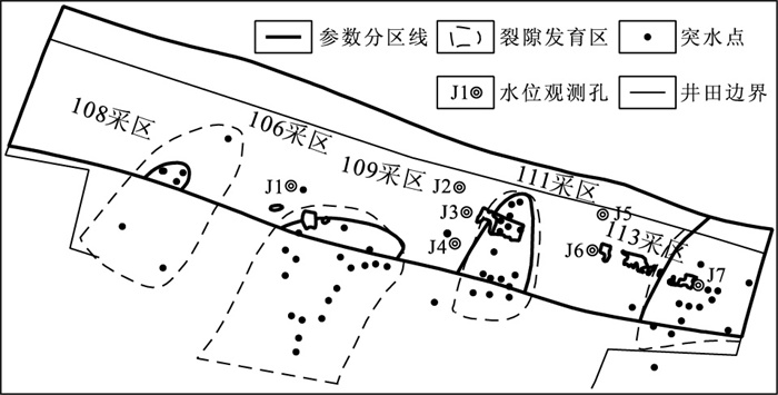
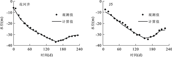
In numerical simulation of mine discharge of karst water, a regional model and a local model are constructed to solve the boundary conceptualization, and the heterogeneity of karst medium is depicted using information compound technology. The regional model of the study area, Xinggong mining area, is constructed due to the fact that it has complete hydrogeological boundary which can provide specified flow values for boundaries in the simulation model of mine discharge in Wanghe coal mine, which is the local model. The vertical and horizontal parameters of the water filling aquifer are divided using information compound technology, based on the analysis of many data such as borehole, structure, water inrush and geophysical investigation. The refined simulation model of mine discharge in Wanghe coal mine is then constructed. The normal mine discharge and maximum mine discharge of different mining faces are forecasted using this model. The results show that when mining the faces of 111070, 113090, 113110 and 113120, the normal mine discharges are 490, 350, 560 and 590 m3/h respectively, and the maximum mine discharges are 690, 490, 790, and 830 m3/h respectively. The results can provide a scientific basis for the mine design department to determine mining scheme, arrange drainage equipment and take measures to control water.
In numerical simulation of mine discharge of karst water, a regional model and a local model are constructed to solve the boundary conceptualization, and the heterogeneity of karst medium is depicted using information compound technology. The regional model of the study area, Xinggong mining area, is constructed due to the fact that it has complete hydrogeological boundary which can provide specified flow values for boundaries in the simulation model of mine discharge in Wanghe coal mine, which is the local model. The vertical and horizontal parameters of the water filling aquifer are divided using information compound technology, based on the analysis of many data such as borehole, structure, water inrush and geophysical investigation. The refined simulation model of mine discharge in Wanghe coal mine is then constructed. The normal mine discharge and maximum mine discharge of different mining faces are forecasted using this model. The results show that when mining the faces of 111070, 113090, 113110 and 113120, the normal mine discharges are 490, 350, 560 and 590 m3/h respectively, and the maximum mine discharges are 690, 490, 790, and 830 m3/h respectively. The results can provide a scientific basis for the mine design department to determine mining scheme, arrange drainage equipment and take measures to control water.

2011, 36(4): 761-764.
doi: 10.3799/dqkx.2011.077
Abstract:
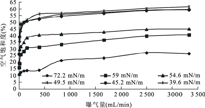
The strengthening effect of anionic surfactant sodium dodecyl benzene sulfonate (SDBS) on air sparging (AS) was investigated using a series of one-dimensional column experiments. The results show that the addition of SDBS into groundwater lowered the groundwater surface tension, which in turn reduced the air entry capillary pressure. As a result, the air saturation in groundwater was increased accordingly. At the air injection rate of 100 mL/min, the surface tension reduction from 72.2 mN/m to 49.5 mN/m led to air saturation enhancement from 13.2% to 50.1%. As the surface tension further decreased, the air saturation no longer increased, but slightly reduced instead. Through the contaminant removal experiment, it was found that the addition of SDBS greatly increased the chlorobenzene removal efficiency, and the change trend of removal efficiency was almost the same to the change of air saturation. Thus, the addition of surfactant into groundwater can be an effective method to enhance air sparging.
The strengthening effect of anionic surfactant sodium dodecyl benzene sulfonate (SDBS) on air sparging (AS) was investigated using a series of one-dimensional column experiments. The results show that the addition of SDBS into groundwater lowered the groundwater surface tension, which in turn reduced the air entry capillary pressure. As a result, the air saturation in groundwater was increased accordingly. At the air injection rate of 100 mL/min, the surface tension reduction from 72.2 mN/m to 49.5 mN/m led to air saturation enhancement from 13.2% to 50.1%. As the surface tension further decreased, the air saturation no longer increased, but slightly reduced instead. Through the contaminant removal experiment, it was found that the addition of SDBS greatly increased the chlorobenzene removal efficiency, and the change trend of removal efficiency was almost the same to the change of air saturation. Thus, the addition of surfactant into groundwater can be an effective method to enhance air sparging.


2011, 36(4): 765-770.
doi: 10.3799/dqkx.2011.078
Abstract:
A certain degree of oil pollution can lead to wettability variation in porous medium, which can bring about low water-holding capacity, oil contamination of groundwater, low food quality and production. In this study, water repellency of sand and clay was measured by WDPT and MED methods under different diesel and engine oil contents. Critical oil content of porous media in oil-contaminated porous media was determined preliminarily, beyond which hydrophilic surface could change into hydrophobic surface. The results show that critical oil contents of clay and sand contaminated by engine oil are about 7% and 0.5% respectively. Critical oil content of sand contaminated by diesel is about 14%, while diesel doesn't have remarkable effect on water repellency. In addition, when water content increases to a critical value, wettability of oil-contaminated porous medium will reverse again. Critical water contents of sand contaminated by engine oil and diesel are both between 0.2%-1%, while critical water content of clay contaminated by engine oil is approximately equal to its oil content in value.
A certain degree of oil pollution can lead to wettability variation in porous medium, which can bring about low water-holding capacity, oil contamination of groundwater, low food quality and production. In this study, water repellency of sand and clay was measured by WDPT and MED methods under different diesel and engine oil contents. Critical oil content of porous media in oil-contaminated porous media was determined preliminarily, beyond which hydrophilic surface could change into hydrophobic surface. The results show that critical oil contents of clay and sand contaminated by engine oil are about 7% and 0.5% respectively. Critical oil content of sand contaminated by diesel is about 14%, while diesel doesn't have remarkable effect on water repellency. In addition, when water content increases to a critical value, wettability of oil-contaminated porous medium will reverse again. Critical water contents of sand contaminated by engine oil and diesel are both between 0.2%-1%, while critical water content of clay contaminated by engine oil is approximately equal to its oil content in value.


2011, 36(4): 771-778.
doi: 10.3799/dqkx.2011.079
Abstract:
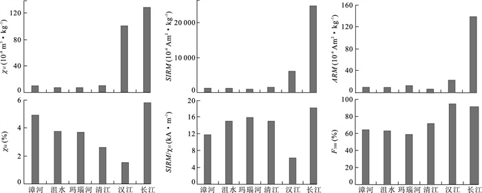
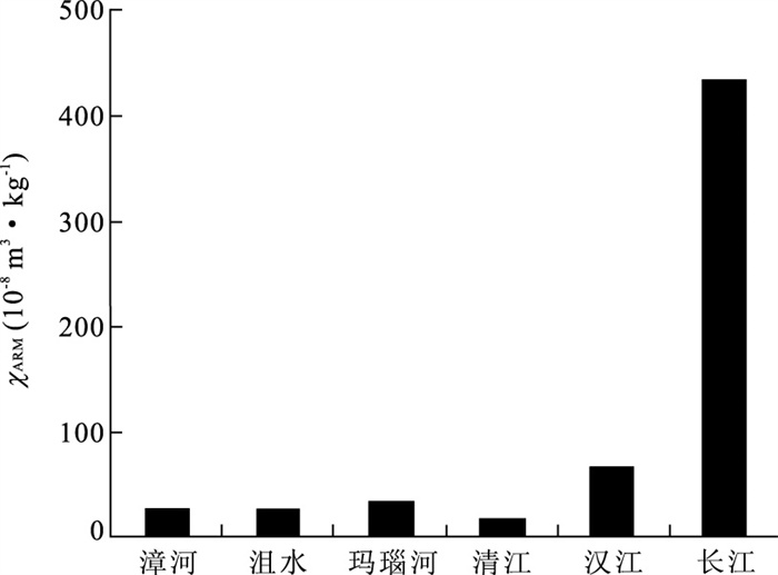
In this paper we report the magnetic characteristics of the confluent river sediments into the Jianghan Plain. Magnetic characteristics are obviously different between different rivers, such as the Yangtze River, Hanjiang River, Zhanghe River, Juhe River, Manaohe River and Qingjiang River, and are well correlated with rock types of the provenance. Magnetic minerals from the Yangtze River and the Hanjiang River are almost ferrimagnetic, which dominate the magnetic characteristics of the samples. Content of ferrimagnetic minerals in the Yangtze River sediments is higher than that in the Hanjiang River. Ferrimagnetic minerals have thicker crystals in the Yangtze River than that in the Hanjiang River, both of which are almost from pseudo-single to multi domain. Higher concentration of ferrimagnetic minerals and thicker magnetic particles are found in the Hanjiang River than the other tributaries of the Yangtze River flowing to Jianghan plain. High concentration of incomplete anti-ferromagnetism minerals and superparamagnetic particles are found in the Mannaohe River and Zhanghe River sediments respectively. High concentration of incomplete anti-ferromagnetism minerals are found in the Qingjiang River sediments, also with thick magnetic particles. Based on the research we conclude that magnetic characteristics of sediments in Jianghan Plain can provide useful information on constraining sediment provenance.
In this paper we report the magnetic characteristics of the confluent river sediments into the Jianghan Plain. Magnetic characteristics are obviously different between different rivers, such as the Yangtze River, Hanjiang River, Zhanghe River, Juhe River, Manaohe River and Qingjiang River, and are well correlated with rock types of the provenance. Magnetic minerals from the Yangtze River and the Hanjiang River are almost ferrimagnetic, which dominate the magnetic characteristics of the samples. Content of ferrimagnetic minerals in the Yangtze River sediments is higher than that in the Hanjiang River. Ferrimagnetic minerals have thicker crystals in the Yangtze River than that in the Hanjiang River, both of which are almost from pseudo-single to multi domain. Higher concentration of ferrimagnetic minerals and thicker magnetic particles are found in the Hanjiang River than the other tributaries of the Yangtze River flowing to Jianghan plain. High concentration of incomplete anti-ferromagnetism minerals and superparamagnetic particles are found in the Mannaohe River and Zhanghe River sediments respectively. High concentration of incomplete anti-ferromagnetism minerals are found in the Qingjiang River sediments, also with thick magnetic particles. Based on the research we conclude that magnetic characteristics of sediments in Jianghan Plain can provide useful information on constraining sediment provenance.


2011, 36(4): 779-788.
doi: 10.3799/dqkx.2011.080
Abstract:
Multi-proxy of environmental magnetism (such as mass susceptibility, frequency dependent susceptibility, saturation isothermal, demagnetizing factor and thermalmagnetic curve) and magnetic fabric parameters derived from the recent sediments at Tianxing Centralshoal of Wuhan are employed to reconstruct the history of paleo-hydrology and climate changes in the mid-upper reaches of the Yangtze River. The assemblage zones of multi-proxy of environmental magnetism indicate that both upper (0.60-1.50 m) and lower (2.40-3.30 m) zones are dominated by the ferromagnetic magnetite. The upper zone is marked by the superparamagnetic grains, which make greater contributions to the mass susceptibility. The percentage of antiferromagnetic minerals in the middle zone (1.50-2.40 m) increases in inverse proportion to the percentage of the ferromagnetic. Therefore, the depth variation of the magnetic mineral contents is like letter C reflecting the magnetic characteristics of "SOFT", "hard" and "SOFT" throughout the section. The analysis on the magnetic fabric parameters demonstrates that hydrodynamic intensity of sedimentary environment, ordering degrees of particle arrangement, and flow velocity of the Yangtze River have undergone significant changes in the past 100 years, which is related to the paleo-hydrological change of the Yangtze River. Variation patterns of magnetic properties in the recent sediments are consistent with the climate change and discharge change at Hankou Station. Especially, hydrodynamic intensity of sedimentary environment has changed from unstable to stable, then unstable, corresponding to the temperature and precipitation changes from hot-wet to cool-dry and hot-wet. Our research has provided significant evidence for further understanding the influence of climate change on the paleo-hydrology and sedimentary environment of the Yangtze River in the historical period.
Multi-proxy of environmental magnetism (such as mass susceptibility, frequency dependent susceptibility, saturation isothermal, demagnetizing factor and thermalmagnetic curve) and magnetic fabric parameters derived from the recent sediments at Tianxing Centralshoal of Wuhan are employed to reconstruct the history of paleo-hydrology and climate changes in the mid-upper reaches of the Yangtze River. The assemblage zones of multi-proxy of environmental magnetism indicate that both upper (0.60-1.50 m) and lower (2.40-3.30 m) zones are dominated by the ferromagnetic magnetite. The upper zone is marked by the superparamagnetic grains, which make greater contributions to the mass susceptibility. The percentage of antiferromagnetic minerals in the middle zone (1.50-2.40 m) increases in inverse proportion to the percentage of the ferromagnetic. Therefore, the depth variation of the magnetic mineral contents is like letter C reflecting the magnetic characteristics of "SOFT", "hard" and "SOFT" throughout the section. The analysis on the magnetic fabric parameters demonstrates that hydrodynamic intensity of sedimentary environment, ordering degrees of particle arrangement, and flow velocity of the Yangtze River have undergone significant changes in the past 100 years, which is related to the paleo-hydrological change of the Yangtze River. Variation patterns of magnetic properties in the recent sediments are consistent with the climate change and discharge change at Hankou Station. Especially, hydrodynamic intensity of sedimentary environment has changed from unstable to stable, then unstable, corresponding to the temperature and precipitation changes from hot-wet to cool-dry and hot-wet. Our research has provided significant evidence for further understanding the influence of climate change on the paleo-hydrology and sedimentary environment of the Yangtze River in the historical period.