2011 Vol. 36, No. 5
Display Method:
2011, 36(5): 789-797.
doi: 10.3799/dqkx.2011.081
 PDF 7113KB
Abstract:
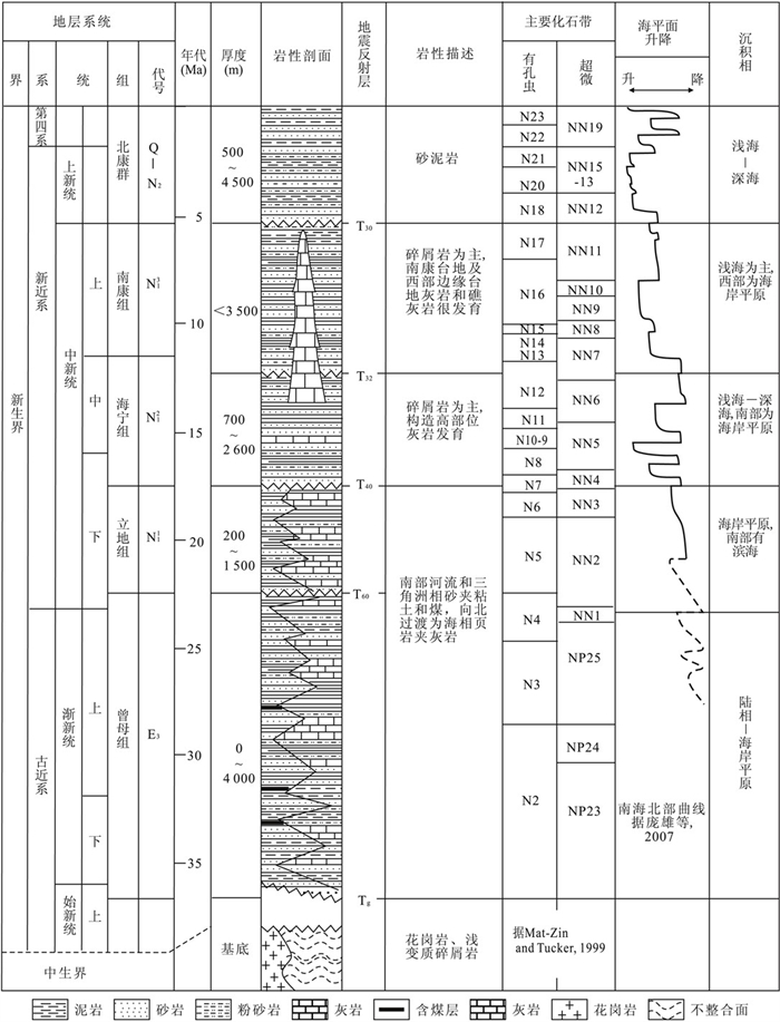
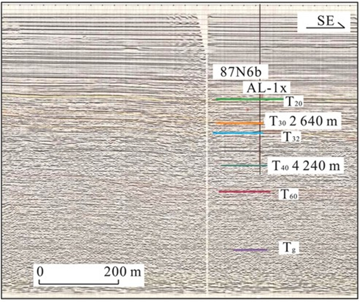
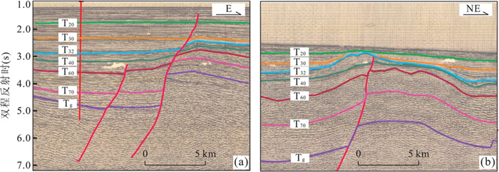
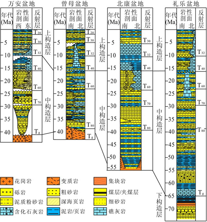
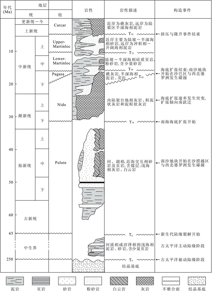
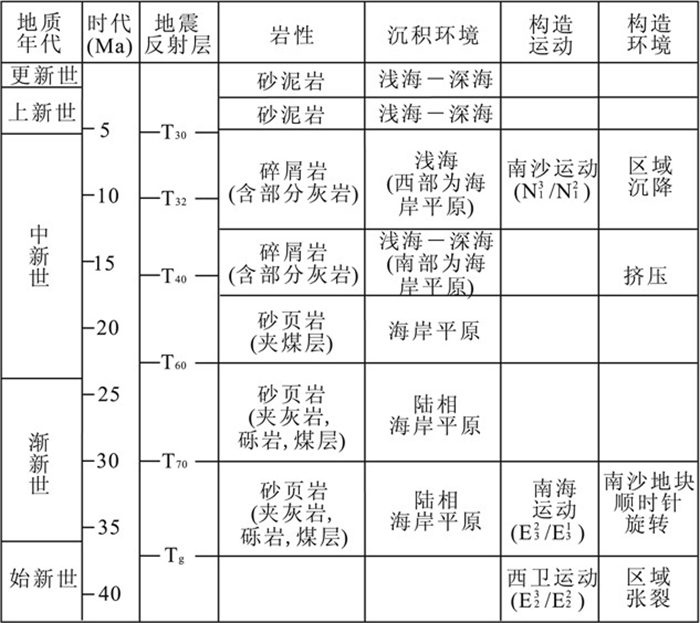
The Zengmu basin is a well-studied hydrocarbon-bearing basin in the Nansha area of the southern South China Sea.The stratigraphic system of the Zengmu basin has been an important element for building regional stratigraphic system.However, the large thickness and quick changes of the strata facies have made it difficult and controversial to divide and date the basin.In order to provide basis for stratigraphic division and correlation in hydrocarbon exploration, we analyze existing data from wells and seismic profiles as well as proposed stratigtraphic columns, and propose a stratigraphic system that is comparable with that used in the exploration of the northern South China Sea.This system combines the numbering system of the CNOOC and the nomenclature of the GMGS, and date the stratigraphic boundaries with existing wells and cross-well seismic profiles.The strata above the basement are divided into four formations and one group (the Zengmu, Lidi, Haining, and Nankang Formations, and the Beikang Group), which are bottomed by five unconformities (Tg, T60, T40, T32, and T30).In order to facilitate the application of this stratigraphic system, the comparison of this scheme with other schemes is also presented, and facies changes within a formation and characteristic unconformities between formations are demonstrated by seismic profiles.
The Zengmu basin is a well-studied hydrocarbon-bearing basin in the Nansha area of the southern South China Sea.The stratigraphic system of the Zengmu basin has been an important element for building regional stratigraphic system.However, the large thickness and quick changes of the strata facies have made it difficult and controversial to divide and date the basin.In order to provide basis for stratigraphic division and correlation in hydrocarbon exploration, we analyze existing data from wells and seismic profiles as well as proposed stratigtraphic columns, and propose a stratigraphic system that is comparable with that used in the exploration of the northern South China Sea.This system combines the numbering system of the CNOOC and the nomenclature of the GMGS, and date the stratigraphic boundaries with existing wells and cross-well seismic profiles.The strata above the basement are divided into four formations and one group (the Zengmu, Lidi, Haining, and Nankang Formations, and the Beikang Group), which are bottomed by five unconformities (Tg, T60, T40, T32, and T30).In order to facilitate the application of this stratigraphic system, the comparison of this scheme with other schemes is also presented, and facies changes within a formation and characteristic unconformities between formations are demonstrated by seismic profiles.


2011, 36(5): 798-806.
doi: 10.3799/dqkx.2011.082
Abstract:
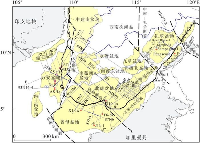
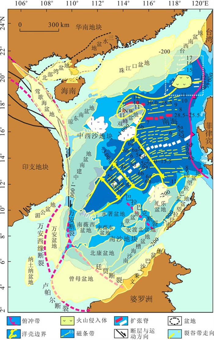
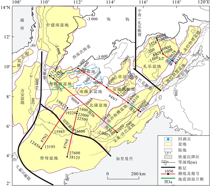
Nansha region is an important part of our country, with great potential for hydrocarbon resources and scientific researches.In order to analyze and compare the basins' structure as well as the sedimentary history systematically, we interprete most of the seismic profiles we have to carry out the stratigraphic correlation between Wan'an, Zengmu (Great Sarawak), Beikang, Nanweixi and Liyue basin.It is found that the stratigraphy are divided into three tectonic periods and four stages, divided by rifting unconformity (Tg), breakup unconformity (T60 or T40), and rifting-depressing unconformity (T40 or T32).The lower tectonic periods are composed of Mesozoic strata, distributed discontinuously, thicker in the Liyue basin and beneath uplift.It's the pre-kinematic sequence.The middle tectonic period is separated into rifting stage in the lower part and rifting-depressing stage in the upper part by T40 in Wan'an and Zengmu basin, and by T60 in Beikang, Nanweixi and Liyue basin.The sedimentation in the rifting-depressing stage may be caused by the drift of the Nansha block.The sequence after T40 (or T32) belongs to depressing stage.According to the rotation, erosion and fold structure, there is a collision event around Middle Miocene (T40), which is especially obvious in Beikang-Nanweixi basin.Besides the folding wave on the surface, the lens-shaped Early Miocene sequence accompanied with newly formed shear faults between T60 and T40 showed a compressive moment around T40, furthermore the Middle Miocene sequence (T40—T32) appear draping with thin top and thick wing.We suppose that the Nansha block collided with Borneo at this time.Relative to the northern continental margin, Zengmu seems much similar with Yinggehai basin, Beikang-Nanweixi basin seems to be conjugate with Qiongdongnan and Zhongjiannan.Liyue basin should be conjugate with Zhongsha uplift by SW sub sea basin.This conjugate pattern is consistent with the phenomena that T60 is the breakup unconformity.
Nansha region is an important part of our country, with great potential for hydrocarbon resources and scientific researches.In order to analyze and compare the basins' structure as well as the sedimentary history systematically, we interprete most of the seismic profiles we have to carry out the stratigraphic correlation between Wan'an, Zengmu (Great Sarawak), Beikang, Nanweixi and Liyue basin.It is found that the stratigraphy are divided into three tectonic periods and four stages, divided by rifting unconformity (Tg), breakup unconformity (T60 or T40), and rifting-depressing unconformity (T40 or T32).The lower tectonic periods are composed of Mesozoic strata, distributed discontinuously, thicker in the Liyue basin and beneath uplift.It's the pre-kinematic sequence.The middle tectonic period is separated into rifting stage in the lower part and rifting-depressing stage in the upper part by T40 in Wan'an and Zengmu basin, and by T60 in Beikang, Nanweixi and Liyue basin.The sedimentation in the rifting-depressing stage may be caused by the drift of the Nansha block.The sequence after T40 (or T32) belongs to depressing stage.According to the rotation, erosion and fold structure, there is a collision event around Middle Miocene (T40), which is especially obvious in Beikang-Nanweixi basin.Besides the folding wave on the surface, the lens-shaped Early Miocene sequence accompanied with newly formed shear faults between T60 and T40 showed a compressive moment around T40, furthermore the Middle Miocene sequence (T40—T32) appear draping with thin top and thick wing.We suppose that the Nansha block collided with Borneo at this time.Relative to the northern continental margin, Zengmu seems much similar with Yinggehai basin, Beikang-Nanweixi basin seems to be conjugate with Qiongdongnan and Zhongjiannan.Liyue basin should be conjugate with Zhongsha uplift by SW sub sea basin.This conjugate pattern is consistent with the phenomena that T60 is the breakup unconformity.


2011, 36(5): 807-814.
doi: 10.3799/dqkx.2011.083
Abstract:
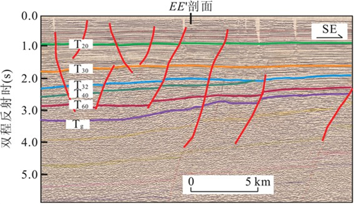
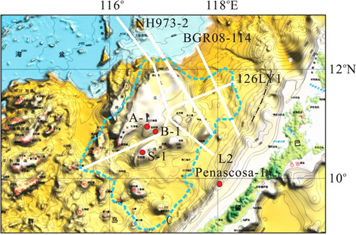
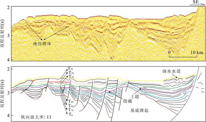
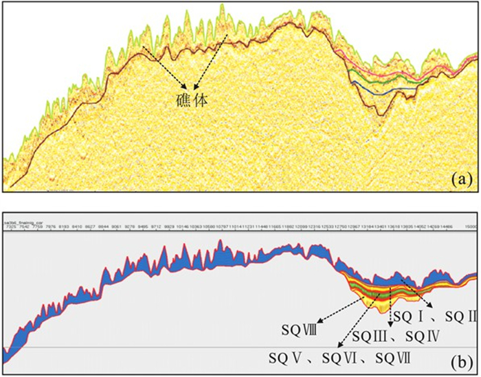
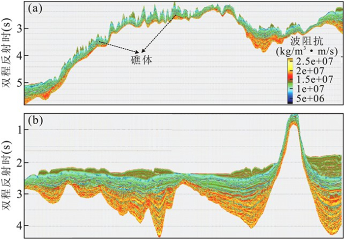
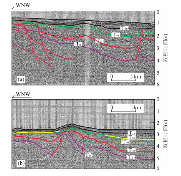
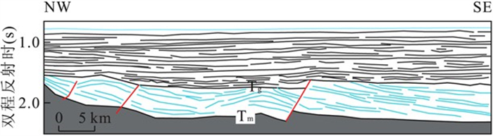
Liyue basin is located in the Nansha block of the South China Sea, which has been subject to compression, rifting, drifting and collision with Borneo block since Mesozoic.It is a complicated superimposed basin with great potential for exploration, with its well developed carbonate platforms being unique targets both for research and exploration.Based on new seismic profile NH973-2, in combination with published well and seismic data, the stratigraphic sequences across the section are analyzed in order to reveal the sedimentary sequences and seismic characters in the Liyue basin.The carbonate platforms are characterized by round external form, chaotic internal reflector.Based on tectonic subsidence calculation, we determine three stages of tectonic evolution in Liyue basin during Cenozoic and come to the conclusion that tectonic actions have had control over the development of Liyue carbonate platform.
Liyue basin is located in the Nansha block of the South China Sea, which has been subject to compression, rifting, drifting and collision with Borneo block since Mesozoic.It is a complicated superimposed basin with great potential for exploration, with its well developed carbonate platforms being unique targets both for research and exploration.Based on new seismic profile NH973-2, in combination with published well and seismic data, the stratigraphic sequences across the section are analyzed in order to reveal the sedimentary sequences and seismic characters in the Liyue basin.The carbonate platforms are characterized by round external form, chaotic internal reflector.Based on tectonic subsidence calculation, we determine three stages of tectonic evolution in Liyue basin during Cenozoic and come to the conclusion that tectonic actions have had control over the development of Liyue carbonate platform.


2011, 36(5): 815-822.
doi: 10.3799/dqkx.2011.084
Abstract:
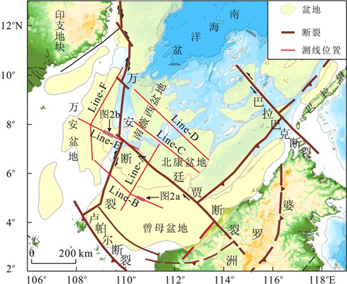
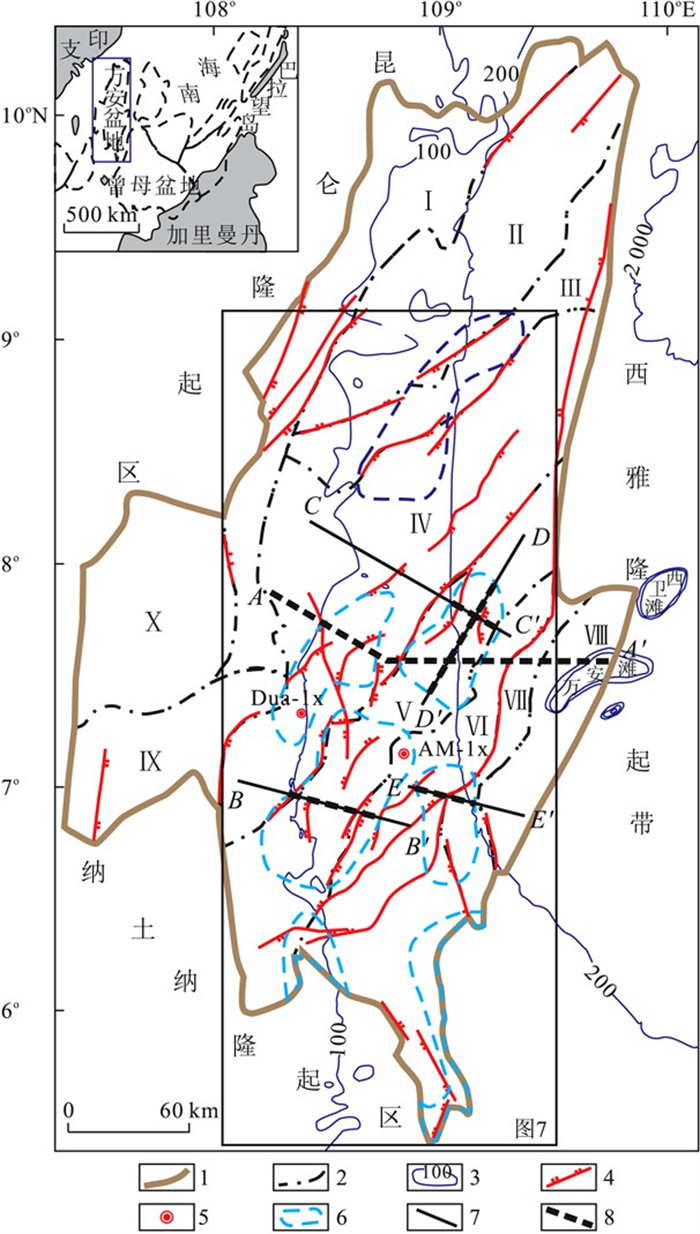
Tectonic evolution in Nansha is analyzed by depicting the faults and calculating the tectonic subsidence along 5 profiles across Nansha.The study shows the following results: 1.T60 (23.8 Ma) is an important tectonic transformation boundary (except for the region around Youngshu basin) because most normal faults have been activated until sequence boundary T40 (16 Ma) or T60 (23.8 Ma) and subsidence curves across the region are characterized by syn-rift basin before T60 (23.8 Ma) and post-rift basin after that.2.The Southeast of Nansha is the outstanding topography with a combination of a NE-SW belt of high subsidence along Nansha trough and its NE elongating zone with a NE-SW belt of thrust to the Southeast indicating there is a stress reverse in T40 boundary.3.There is high subsidence period since 5.3 Ma which may relate to the weakness of compression to the SE of Nansha.
Tectonic evolution in Nansha is analyzed by depicting the faults and calculating the tectonic subsidence along 5 profiles across Nansha.The study shows the following results: 1.T60 (23.8 Ma) is an important tectonic transformation boundary (except for the region around Youngshu basin) because most normal faults have been activated until sequence boundary T40 (16 Ma) or T60 (23.8 Ma) and subsidence curves across the region are characterized by syn-rift basin before T60 (23.8 Ma) and post-rift basin after that.2.The Southeast of Nansha is the outstanding topography with a combination of a NE-SW belt of high subsidence along Nansha trough and its NE elongating zone with a NE-SW belt of thrust to the Southeast indicating there is a stress reverse in T40 boundary.3.There is high subsidence period since 5.3 Ma which may relate to the weakness of compression to the SE of Nansha.


2011, 36(5): 823-830.
doi: 10.3799/dqkx.2011.085
Abstract:
The deep seismic surveys in the southern South China Sea (SCS) are of vital importance for conjugate continental margins and the theory of formation and evolution of SCS.This paper firstly reviews the survey history, then analyzes the geological and geophysical characteristics and finally presents the significance of deep structure research in southern SCS based on comparing the conjugate continental margins with Newfoundland and Iberia.Deep structures of the southwestern sub-basin, velocity structures of sea mountains in the deep basin, and the whole rifting system could make breakthrough for the theory of formation and evolution of the SCS in the future.
The deep seismic surveys in the southern South China Sea (SCS) are of vital importance for conjugate continental margins and the theory of formation and evolution of SCS.This paper firstly reviews the survey history, then analyzes the geological and geophysical characteristics and finally presents the significance of deep structure research in southern SCS based on comparing the conjugate continental margins with Newfoundland and Iberia.Deep structures of the southwestern sub-basin, velocity structures of sea mountains in the deep basin, and the whole rifting system could make breakthrough for the theory of formation and evolution of the SCS in the future.


2011, 36(5): 831-836.
doi: 10.3799/dqkx.2011.086
Abstract:
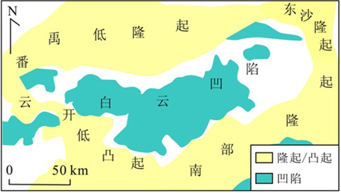
Baiyun depression is characterized by high geotemperature and high pressure formation.By theory of geotemperature-pressure system, the geotemperature, formation pressure and geotemperature-pressure system at Baiyun depression and their relationships with hydrocarbon distribution are analyzed in vertical and lateral sections.Research shows that overpressure composite geotemperature-pressure system develops at Baiyun depression, namely normal geotemperature-pressure system of shallow zone and overpressure system of deep zone.Based on coupling characteristics of geotemperature and pressure, Baiyun depression is divided into six geotemperature-pressure system divisions.The northern slope belt is located in the area with high temperature and normal pressure, as well as high temperature and high pressure.The main sag is mainly located in the area with ultra high temperature and high pressure, and the center belt belongs to ultra high temperature and ultra high pressure region.The southern slope belt is located in the area with high temperature and high pressure.Natural gas pools are mainly distributed in relative low energy area.The special characteristics of geotemperature-pressure system at Baiyun depression provide strong power for hydrocarbon migration, and control the distribution of oil and gas reservoirs.
Baiyun depression is characterized by high geotemperature and high pressure formation.By theory of geotemperature-pressure system, the geotemperature, formation pressure and geotemperature-pressure system at Baiyun depression and their relationships with hydrocarbon distribution are analyzed in vertical and lateral sections.Research shows that overpressure composite geotemperature-pressure system develops at Baiyun depression, namely normal geotemperature-pressure system of shallow zone and overpressure system of deep zone.Based on coupling characteristics of geotemperature and pressure, Baiyun depression is divided into six geotemperature-pressure system divisions.The northern slope belt is located in the area with high temperature and normal pressure, as well as high temperature and high pressure.The main sag is mainly located in the area with ultra high temperature and high pressure, and the center belt belongs to ultra high temperature and ultra high pressure region.The southern slope belt is located in the area with high temperature and high pressure.Natural gas pools are mainly distributed in relative low energy area.The special characteristics of geotemperature-pressure system at Baiyun depression provide strong power for hydrocarbon migration, and control the distribution of oil and gas reservoirs.


2011, 36(5): 837-844.
doi: 10.3799/dqkx.2011.087
Abstract:
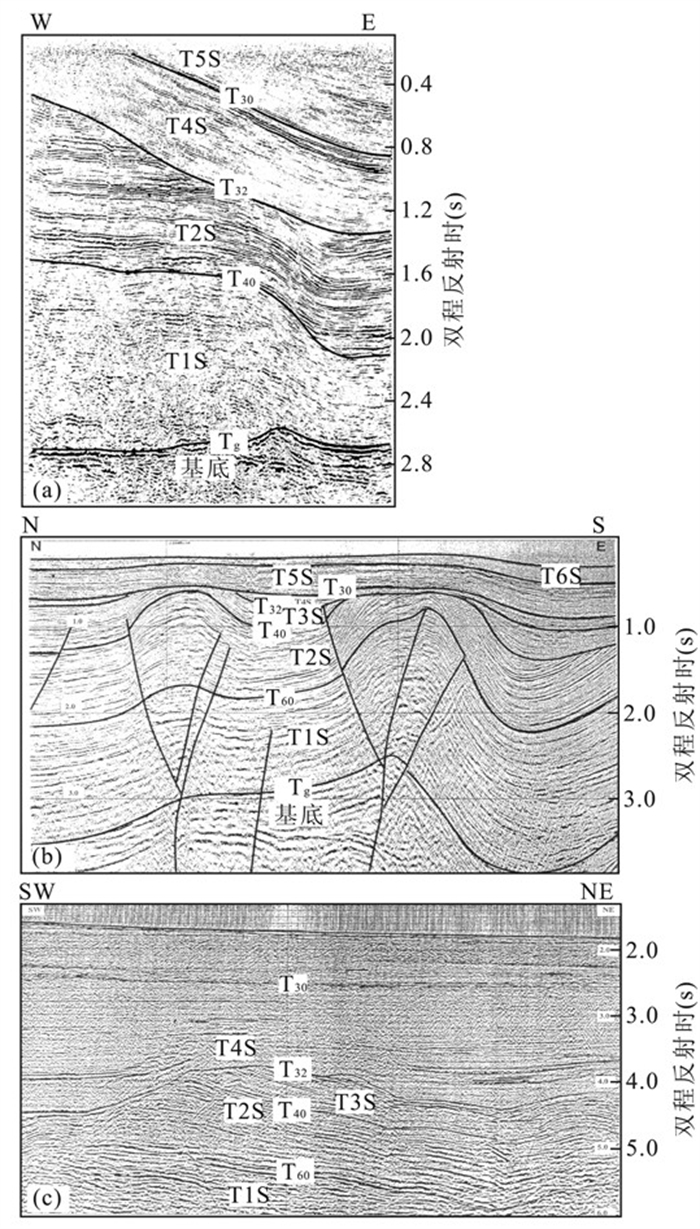
The evolution of rift-drift-subsidence can usually be illuminated by sedimental style, subsidence history and structural style, so it's possible to understand basin evolution through analysis of depositional process and coupling tectonic-sedimentary.In this paper, infill stratigraphy, subsidence history and structural characteristics are analyzed.The results show that Liyue basin is characterized by typical "tow-layer" structural pattern, which is separated by a regional breakup unconformity (T60). The horsts and grabens are in low basin overlain by upper depressions of the Neogene.And the half-grabens characterized by asymmetric wedge-shape are bounded by both normal faults and large-scale listric faults, which controlled the sedimentary cycles.The subsidence method is mainly tectonic subsidence before 23.8 Ma but is thermal subsidence after Late Oligocene.There were three regional subsidence episodes, and each subsidence rate was from slow to fast.Liyue basin is primarily composed of three regressive cycles of rift infilling influenced by regional tectonic, which correspond to three stages of basin development.The first stage, characterized by extensional stress, is related to early rift development from approximately 45 Ma until Early Oligocene.Featured by both extension and strike-slip stress, the second is associated with rift-drift development from initiation of sea floor spreading in South China Sea at 30 Ma until the end of sea floor spreading at Middle Miocene.And the third is late post-rift subsidence from approximately 16 Ma until 5.5 Ma, which is controlled by transpressive stress field.
The evolution of rift-drift-subsidence can usually be illuminated by sedimental style, subsidence history and structural style, so it's possible to understand basin evolution through analysis of depositional process and coupling tectonic-sedimentary.In this paper, infill stratigraphy, subsidence history and structural characteristics are analyzed.The results show that Liyue basin is characterized by typical "tow-layer" structural pattern, which is separated by a regional breakup unconformity (T60). The horsts and grabens are in low basin overlain by upper depressions of the Neogene.And the half-grabens characterized by asymmetric wedge-shape are bounded by both normal faults and large-scale listric faults, which controlled the sedimentary cycles.The subsidence method is mainly tectonic subsidence before 23.8 Ma but is thermal subsidence after Late Oligocene.There were three regional subsidence episodes, and each subsidence rate was from slow to fast.Liyue basin is primarily composed of three regressive cycles of rift infilling influenced by regional tectonic, which correspond to three stages of basin development.The first stage, characterized by extensional stress, is related to early rift development from approximately 45 Ma until Early Oligocene.Featured by both extension and strike-slip stress, the second is associated with rift-drift development from initiation of sea floor spreading in South China Sea at 30 Ma until the end of sea floor spreading at Middle Miocene.And the third is late post-rift subsidence from approximately 16 Ma until 5.5 Ma, which is controlled by transpressive stress field.


2011, 36(5): 845-852.
doi: 10.3799/dqkx.2011.088
Abstract:
Wan'an basin, as a typical Cenozoic transtensional basin, is one of the most important petroliferous basins in the southwestern of South China Sea.In this study, using seismic, drilling and some palaeontologic data, the Cenozoic sequence stratum pattern in Wan'an basin is established, which is subdivided into three super-sequences, six secondary sequences and ten tertiary sequences.In this sequence, the depositional process of Cenozoic strata in Wan'an basin is interpreted as gradually transgression based on comparative study of seismic and drilling data.SSQ1 and SSQ2 sequences are predominantly composed of lacustrine deposits during syn-rift.And SSQ3, SSQ4, SSQ5 as well as SSQ6 sequences are characterized by transitional facies and marine deposit.According to the interpretation of the lithofacies and sedimentary facies from typical seismic profiles, several kinds of lithostratigraphic traps are recognized and predicted, including basin floor fan, turbidite fan and colluvial mass in low-stand system tracts; upward wedge-out sands in transgressive system tracts; and delta sands and biohermal suite in high-stand system tracts.
Wan'an basin, as a typical Cenozoic transtensional basin, is one of the most important petroliferous basins in the southwestern of South China Sea.In this study, using seismic, drilling and some palaeontologic data, the Cenozoic sequence stratum pattern in Wan'an basin is established, which is subdivided into three super-sequences, six secondary sequences and ten tertiary sequences.In this sequence, the depositional process of Cenozoic strata in Wan'an basin is interpreted as gradually transgression based on comparative study of seismic and drilling data.SSQ1 and SSQ2 sequences are predominantly composed of lacustrine deposits during syn-rift.And SSQ3, SSQ4, SSQ5 as well as SSQ6 sequences are characterized by transitional facies and marine deposit.According to the interpretation of the lithofacies and sedimentary facies from typical seismic profiles, several kinds of lithostratigraphic traps are recognized and predicted, including basin floor fan, turbidite fan and colluvial mass in low-stand system tracts; upward wedge-out sands in transgressive system tracts; and delta sands and biohermal suite in high-stand system tracts.


2011, 36(5): 853-860.
doi: 10.3799/dqkx.2011.089
Abstract:
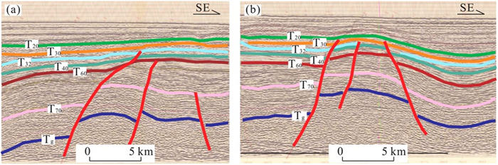
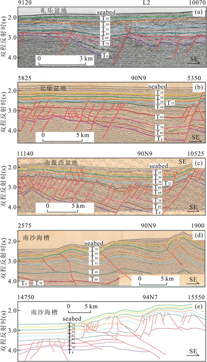
To further understand the characteristics and tectonic evolution of sedimentary in the central waters of the Nansha, we select typical survey line 02N02 in this area and present detailed interpretation of its structure and stratigraphy.It finds that there is a set of thick Mesozoic or even older strata in the area, especially in the southern area, which generally has strong folding, and there is a series of NE-NEE-trending faults controlling the deposition obviously in the wings of folds.Anticline has been eroded at the top, deposited in the wings.The filling and coating deposition between Cenozoic Tg (the top of Middle Eocene) and T40 (the bottom of Middle Miocene) interface in rift valleys were controlled by faults, and the formation of cap rock above T40 with little change in stratigraphic thickness were less controlled by faults.Combining these features above and comparing the line 87N4 intersecting with line 02N02 and the line 90N9 nearby the line 02N02 to the east, and the line 94N2 crossing this area, we analyze the Mesozoic and Cenozoic tectonic origin of the central Nansha Sea area, and further discuss its evolution.
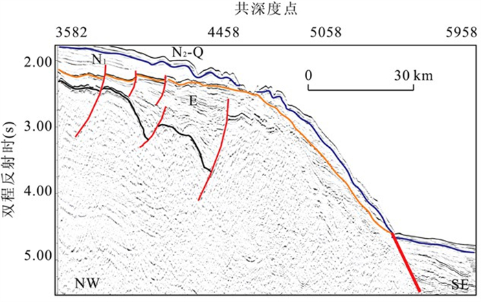
To further understand the characteristics and tectonic evolution of sedimentary in the central waters of the Nansha, we select typical survey line 02N02 in this area and present detailed interpretation of its structure and stratigraphy.It finds that there is a set of thick Mesozoic or even older strata in the area, especially in the southern area, which generally has strong folding, and there is a series of NE-NEE-trending faults controlling the deposition obviously in the wings of folds.Anticline has been eroded at the top, deposited in the wings.The filling and coating deposition between Cenozoic Tg (the top of Middle Eocene) and T40 (the bottom of Middle Miocene) interface in rift valleys were controlled by faults, and the formation of cap rock above T40 with little change in stratigraphic thickness were less controlled by faults.Combining these features above and comparing the line 87N4 intersecting with line 02N02 and the line 90N9 nearby the line 02N02 to the east, and the line 94N2 crossing this area, we analyze the Mesozoic and Cenozoic tectonic origin of the central Nansha Sea area, and further discuss its evolution.


2011, 36(5): 861-868.
doi: 10.3799/dqkx.2011.090
Abstract:
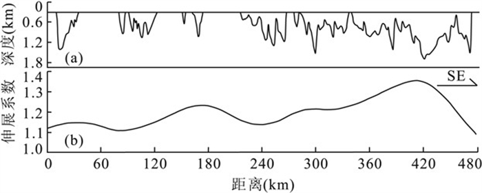
The Liyue block is composed of two parts, namely, Reed Bank and Liyue basin, which is separated by Zhongnan fault in west, Palawan trough in southeast and fault scarp in the north of Nansha area.Based on gravity and seismic data set, a systematic investigation on major tectonic and crust structure units in the Liyue block is made.Multichannel seismic data can better our understanding of the stratum and fault structure located in the sediment basement.In the Reed Bank, composed of reefs, the faults are undeveloped and the stratum is flat.In the basin area, the early faults are developed with two kinds of structures: tilted fault block and low relief anticline.The thickness of the Mesozoic strata in basin area decreases from SW to NE.But the thickness of rifting strata increases from SW to NE, which indicates the fault activity strength in the rift period increases from southwest to northeast.Gravity inversion is performed to understand the geometry of the MOHO surface and the crustal thicknesses beneath.The region is characterized by a large positive Bouguer gravity anomaly (60 to 140 mGal), and the MOHO depth generally varies from 16 to 27 km.In general, crustal structures can be distinguished from the thinned continental crust.The Liyue block is characterized by stretching factors ranging from 1.3 to 2.0, which indicates that the local region is lowly stretched.
The Liyue block is composed of two parts, namely, Reed Bank and Liyue basin, which is separated by Zhongnan fault in west, Palawan trough in southeast and fault scarp in the north of Nansha area.Based on gravity and seismic data set, a systematic investigation on major tectonic and crust structure units in the Liyue block is made.Multichannel seismic data can better our understanding of the stratum and fault structure located in the sediment basement.In the Reed Bank, composed of reefs, the faults are undeveloped and the stratum is flat.In the basin area, the early faults are developed with two kinds of structures: tilted fault block and low relief anticline.The thickness of the Mesozoic strata in basin area decreases from SW to NE.But the thickness of rifting strata increases from SW to NE, which indicates the fault activity strength in the rift period increases from southwest to northeast.Gravity inversion is performed to understand the geometry of the MOHO surface and the crustal thicknesses beneath.The region is characterized by a large positive Bouguer gravity anomaly (60 to 140 mGal), and the MOHO depth generally varies from 16 to 27 km.In general, crustal structures can be distinguished from the thinned continental crust.The Liyue block is characterized by stretching factors ranging from 1.3 to 2.0, which indicates that the local region is lowly stretched.


2011, 36(5): 869-876.
doi: 10.3799/dqkx.2011.091
Abstract:
The Cenozoic stratigraphic interpretation of lower continental slope in the northern South China Sea is studied and compared with Baiyun sag, to understand the sedimentary characteristics and stratigraphic distribution of deep water basin for environmental impact of construction, based on the seismic profiles acquired by SO49 and 973 cruises.The Cenozoic sediments of lower continental slope in southern Baiyun sag can be divided into eight stratas, namely, Pliocene-Quaternary, Late Miocene, Middle Miocene, Early Miocene, Late Oligocene, Late Eocene-Early Oligocene, Middle Eocene, Paleogene-Early Eocene.The tectonic evolution of lower continental slope depressions can be divided into following stages: rifting, rifting-depression transitional and depression stages, while their depositional environments change from river to shallow marine and abyssa1, which results in different topography in different stages.The topographic evolvement in the study area includes three stages, that is, Neocene to present, Late Oligocene, Early Oligocene and Paleogene.
The Cenozoic stratigraphic interpretation of lower continental slope in the northern South China Sea is studied and compared with Baiyun sag, to understand the sedimentary characteristics and stratigraphic distribution of deep water basin for environmental impact of construction, based on the seismic profiles acquired by SO49 and 973 cruises.The Cenozoic sediments of lower continental slope in southern Baiyun sag can be divided into eight stratas, namely, Pliocene-Quaternary, Late Miocene, Middle Miocene, Early Miocene, Late Oligocene, Late Eocene-Early Oligocene, Middle Eocene, Paleogene-Early Eocene.The tectonic evolution of lower continental slope depressions can be divided into following stages: rifting, rifting-depression transitional and depression stages, while their depositional environments change from river to shallow marine and abyssa1, which results in different topography in different stages.The topographic evolvement in the study area includes three stages, that is, Neocene to present, Late Oligocene, Early Oligocene and Paleogene.


2011, 36(5): 877-885.
doi: 10.3799/dqkx.2011.092
Abstract:
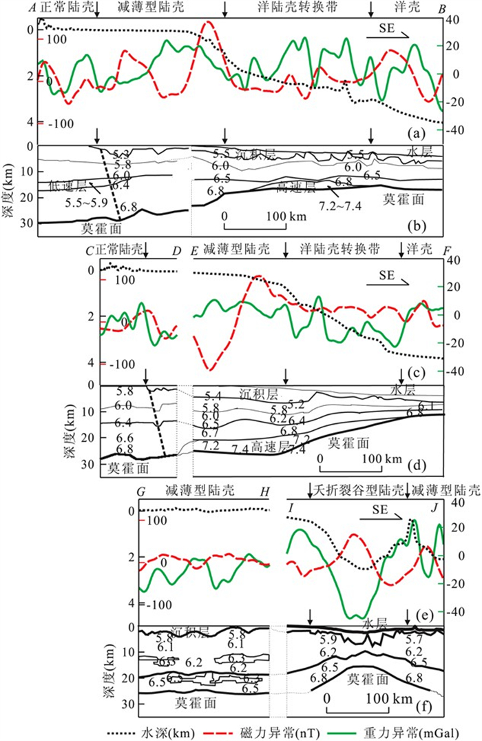
In order to analyze crustal structures and features in the conjugate margins of South China Sea (SCS), we collected large numbers of studied results from the ocean bottom seismometers experiments, onshore-offshore seismic experiments, gravity and magnetism anomalies.This paper firstly constructs three land-sea super cross-sections from east to west in the northern margin of SCS.The results show the onshore-offshore transitional zone is a border separating the unstretched and the stretched continental crust.The low velocity layer (LVL) in the middle crust was widely imaged in the unstretched continental crust.However, the high velocity layer (HVL) in the lower crust was detected in the stretched continental crust.By analyzing the mechanisms of the LVL in the middle crust and HVL in the base of crust, we believe the crustal structures had distinctly different attributes in the continental South China and in the northern SCS, which indicates that the littoral fault zone (LFZ) could be the boundary fault between them.Then, we reveal the crustal features in the Liyue Bank based on water depth, gravity and magnetism anomalies.The Moho depth thins from about 24 km in the Liyne bank to 11 km in the oceanic basin.The ocean-continent transitional zone generally widens from east to west in the southern margin.Finally, we devide the crustal structure in the conjugated margin of SCS into four types, including the unstretched continental crust, the stretched continental crust, the ocean-continent transitional zone, and the ancient ocean crust.
In order to analyze crustal structures and features in the conjugate margins of South China Sea (SCS), we collected large numbers of studied results from the ocean bottom seismometers experiments, onshore-offshore seismic experiments, gravity and magnetism anomalies.This paper firstly constructs three land-sea super cross-sections from east to west in the northern margin of SCS.The results show the onshore-offshore transitional zone is a border separating the unstretched and the stretched continental crust.The low velocity layer (LVL) in the middle crust was widely imaged in the unstretched continental crust.However, the high velocity layer (HVL) in the lower crust was detected in the stretched continental crust.By analyzing the mechanisms of the LVL in the middle crust and HVL in the base of crust, we believe the crustal structures had distinctly different attributes in the continental South China and in the northern SCS, which indicates that the littoral fault zone (LFZ) could be the boundary fault between them.Then, we reveal the crustal features in the Liyue Bank based on water depth, gravity and magnetism anomalies.The Moho depth thins from about 24 km in the Liyne bank to 11 km in the oceanic basin.The ocean-continent transitional zone generally widens from east to west in the southern margin.Finally, we devide the crustal structure in the conjugated margin of SCS into four types, including the unstretched continental crust, the stretched continental crust, the ocean-continent transitional zone, and the ancient ocean crust.


2011, 36(5): 886-894.
doi: 10.3799/dqkx.2011.093
Abstract:
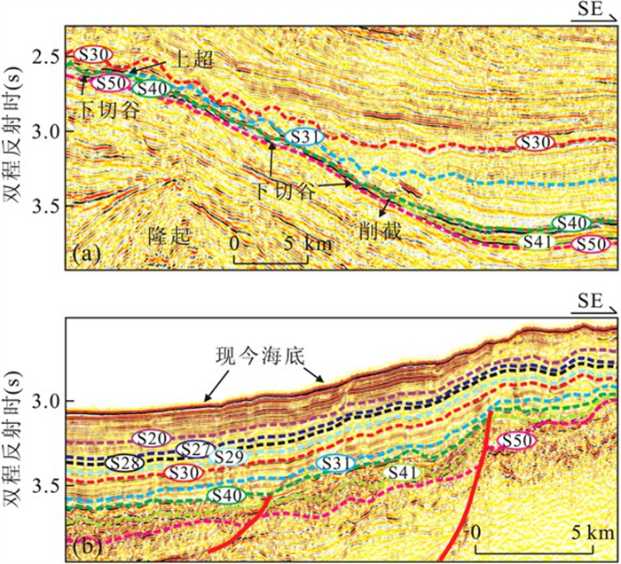
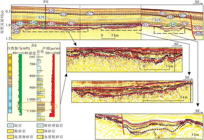
Based on the integrated study of 2D seismic data, well data and biostratigraphy in the Qiongdongnan basin (QDNB), the Late Miocene unconformity (S40) at about 11.6 Ma which separated the underlying Meishan and overlying Huangliu Formation is interpreted.The characters of S40 including sea level changes, seismic-sedimentary facies and subsidence rate show significant differences in its eastern and western areas as follows: (1) In the littoral-neritic area of the northwestern QDNB, it is angular with intense erosion of the underlying strata, and even erosion of the whole Meishan Formation. (2) In the bathyal-abyssal area of southeastern QDNB, Meishan Formation is characterized by higher amplitude, generally continuous-hummocky and even progradational reflection, whereas Huangliu Formation is featured with low-amplitude, continuous facies.We suggest that the S40 interface displaying different characteristics was controlled by different mechanism factors, the western basin was strongly eroded by the underlying strata under the influence of massive sea-level fall; whereas the eastern basin with great subsidence occurred due to the Xisha trough activity since Late Miocene.This tectonic activity caused the eastern QDNB to change abruptly from shallow water to semi-deep or deep water environment, consequently the basin exhibits deep and shallow landforms in the east and west respectively.This topography remains until the present day.The interpretation of S40 is helpful not only to explain the South China Sea evolution but also to predict potential reservoir target.
Based on the integrated study of 2D seismic data, well data and biostratigraphy in the Qiongdongnan basin (QDNB), the Late Miocene unconformity (S40) at about 11.6 Ma which separated the underlying Meishan and overlying Huangliu Formation is interpreted.The characters of S40 including sea level changes, seismic-sedimentary facies and subsidence rate show significant differences in its eastern and western areas as follows: (1) In the littoral-neritic area of the northwestern QDNB, it is angular with intense erosion of the underlying strata, and even erosion of the whole Meishan Formation. (2) In the bathyal-abyssal area of southeastern QDNB, Meishan Formation is characterized by higher amplitude, generally continuous-hummocky and even progradational reflection, whereas Huangliu Formation is featured with low-amplitude, continuous facies.We suggest that the S40 interface displaying different characteristics was controlled by different mechanism factors, the western basin was strongly eroded by the underlying strata under the influence of massive sea-level fall; whereas the eastern basin with great subsidence occurred due to the Xisha trough activity since Late Miocene.This tectonic activity caused the eastern QDNB to change abruptly from shallow water to semi-deep or deep water environment, consequently the basin exhibits deep and shallow landforms in the east and west respectively.This topography remains until the present day.The interpretation of S40 is helpful not only to explain the South China Sea evolution but also to predict potential reservoir target.


2011, 36(5): 895-904.
doi: 10.3799/dqkx.2011.094
Abstract:
One recently acquired regional multi-channel seismic profile (NH973-2) across the Reed Bank basin, the South China Sea (SCS), is interpreted.Based on the interpretations of these profiles, we have worked out its stratigraphic sequences, tectonic structures and extension factors.Four tectonic-stratigraphic units are determined, together with 6 sequence boundaries.Detailed analyses on the extension factors based on the measurement of fault heaves reveal two episodes of continental extension separated by a distinct unconformity.The main extension occurred during the continental rifting (Early Tertiary), and resulted in the formation of half-grabens and rotated blocks, controlled by deeply rooted detachment system.During the second extension phase (drifting period, Late Oligocene-Early Miocene) intensity reduced sharply and focused on the continental-oceanic transition area.A widespread carbonate platform developed across the Reed bank region concurrent with the drifting period of the SCS.Fault-related stretching factor (βf) is found to be comparable and shows discrepancy with the whole crust stretching factors (βc) in the study area.Thus we conclude that the continental crust of the Reed Bank basin experienced depth-dependent extension.
One recently acquired regional multi-channel seismic profile (NH973-2) across the Reed Bank basin, the South China Sea (SCS), is interpreted.Based on the interpretations of these profiles, we have worked out its stratigraphic sequences, tectonic structures and extension factors.Four tectonic-stratigraphic units are determined, together with 6 sequence boundaries.Detailed analyses on the extension factors based on the measurement of fault heaves reveal two episodes of continental extension separated by a distinct unconformity.The main extension occurred during the continental rifting (Early Tertiary), and resulted in the formation of half-grabens and rotated blocks, controlled by deeply rooted detachment system.During the second extension phase (drifting period, Late Oligocene-Early Miocene) intensity reduced sharply and focused on the continental-oceanic transition area.A widespread carbonate platform developed across the Reed bank region concurrent with the drifting period of the SCS.Fault-related stretching factor (βf) is found to be comparable and shows discrepancy with the whole crust stretching factors (βc) in the study area.Thus we conclude that the continental crust of the Reed Bank basin experienced depth-dependent extension.


2011, 36(5): 905-913.
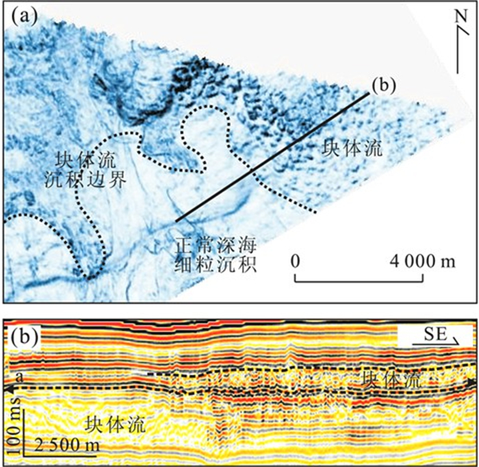
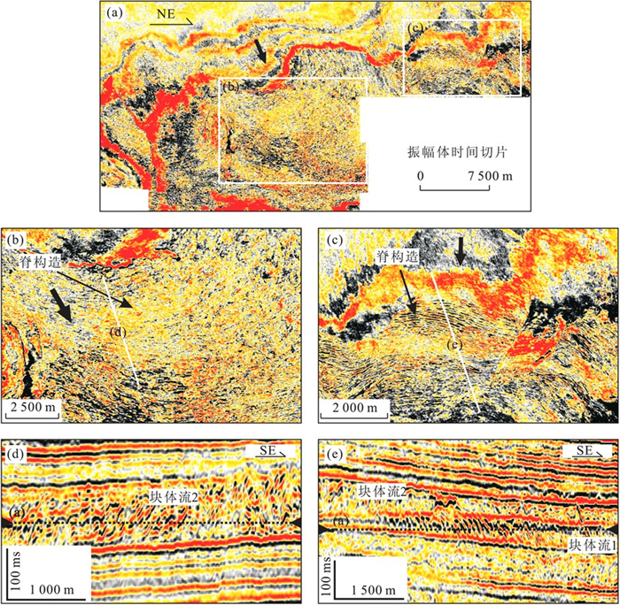
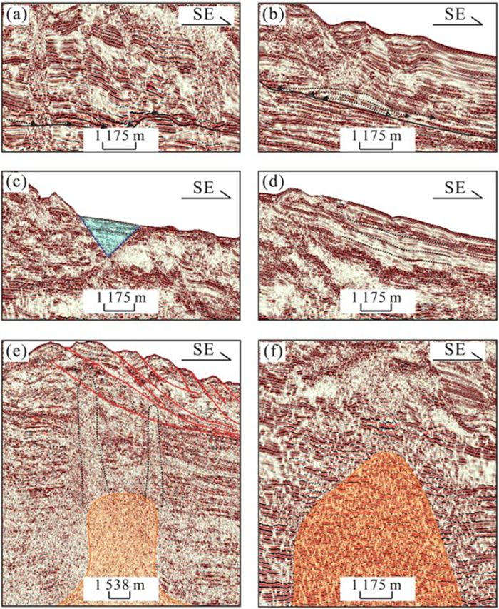
doi: 10.3799/dqkx.2011.095
Abstract:
In order to understand the deepwater depositional system in Qiongdongnan basin better, this study interprets the deepwater depositional architectures based on the regional 2D and 3D seismic data and it is found that large-scale MTDs are well developed in Qiongdongnan basin.According to the detailed study on MTDs, typical elements have been identified such as slide, escarpment, transported blocks, remnant blocks, compression ridge, thrust fault and ponded depositon on the irregular top surface.The MTDs on the slope with steep angles are characterized by chaotic seismic facies with tense deformation, while those on the gentle-angle slope are characterized by the slide with less deformation, which indicates that the angle of the slope has obvious control effect on the development and internal architecture features of MTDs.Being regarded as an important part of deepwater deposition, MTDs have an important effect on the spatial distribution of sediment in deepwater.On the one hand, the irregular top surface of MTDs affects the distribution and internal architecture of succedent sediments; on the other hand, MTDs erodes the former strata directly and wrecks the internal structure of former strata.And also, the erosion can give rise to effusion of the fluid in potential reservoir.Hence, according to its important role in deepwater deposition system, it is necessary to further the elaborate study on the MTDs to make the deepwater exploration more efficiently.
In order to understand the deepwater depositional system in Qiongdongnan basin better, this study interprets the deepwater depositional architectures based on the regional 2D and 3D seismic data and it is found that large-scale MTDs are well developed in Qiongdongnan basin.According to the detailed study on MTDs, typical elements have been identified such as slide, escarpment, transported blocks, remnant blocks, compression ridge, thrust fault and ponded depositon on the irregular top surface.The MTDs on the slope with steep angles are characterized by chaotic seismic facies with tense deformation, while those on the gentle-angle slope are characterized by the slide with less deformation, which indicates that the angle of the slope has obvious control effect on the development and internal architecture features of MTDs.Being regarded as an important part of deepwater deposition, MTDs have an important effect on the spatial distribution of sediment in deepwater.On the one hand, the irregular top surface of MTDs affects the distribution and internal architecture of succedent sediments; on the other hand, MTDs erodes the former strata directly and wrecks the internal structure of former strata.And also, the erosion can give rise to effusion of the fluid in potential reservoir.Hence, according to its important role in deepwater deposition system, it is necessary to further the elaborate study on the MTDs to make the deepwater exploration more efficiently.


2011, 36(5): 914-920.
doi: 10.3799/dqkx.2011.096
Abstract:
Guangzhou marine geological survey have carried out a number of voyages for gas hydrate investigation and research at the continental slope of northern South China Sea since 2000 and has acquired abundance of seismic data.On the basis of detailed interpretation of those seismic data, this paper recognizes six typical seismic facies, namely lenticular progradation facies, hummocky progradation facies, V-shaped filling facies, sheet parallel facies, diapir-gas chimney disorder facies and hummocky disorder facies.Thus developed three sedimentary facies including deep sea fan, slump and canyon channel facies.Combined with the distribution of the bottom simulating reflector (BSR) in the study area and the spatial relationship of the BSR with the variety of sedimentary facies, three gas hydrate accumulation models have been established as follows: fault communication with deep sea fan, fault communication with canyon channel and fault communication with canyon channel and slump fan.
Guangzhou marine geological survey have carried out a number of voyages for gas hydrate investigation and research at the continental slope of northern South China Sea since 2000 and has acquired abundance of seismic data.On the basis of detailed interpretation of those seismic data, this paper recognizes six typical seismic facies, namely lenticular progradation facies, hummocky progradation facies, V-shaped filling facies, sheet parallel facies, diapir-gas chimney disorder facies and hummocky disorder facies.Thus developed three sedimentary facies including deep sea fan, slump and canyon channel facies.Combined with the distribution of the bottom simulating reflector (BSR) in the study area and the spatial relationship of the BSR with the variety of sedimentary facies, three gas hydrate accumulation models have been established as follows: fault communication with deep sea fan, fault communication with canyon channel and fault communication with canyon channel and slump fan.


2011, 36(5): 921-930.
doi: 10.3799/dqkx.2011.097
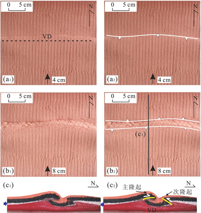
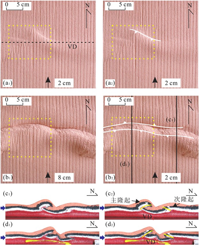
Abstract:
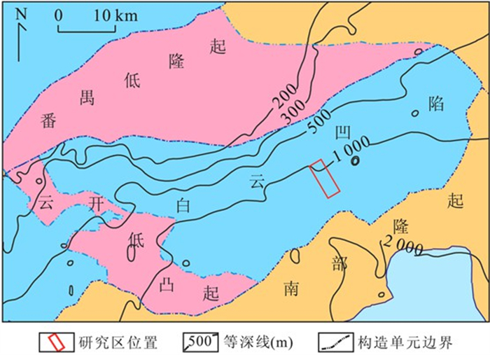
To investigate the influence of weakness body on compression, we carry out six sets of analogue modeling experiments to study the impact of size, location as well as the force direction of weakness body on structural deformation.Based on the modeling results, effects of weakness body on compression structure deformation in the Yinggehai and Qiongdongnan basin are discussed.Experiments show that during compression, uplift first appears and propagates rapidly in area with weakness body, then the uplift appears in non-weakness body, the uplift area in weakness body is bigger than that in area without weakness body, and its fold deformation is stronger than that of non-weakness body.With larger weakness body, the deformation region of weakness body becomes bigger, and the deformation gets stronger.However, the deformation region of non-weakness body stays stable.When the weakness body is located closer to compressive boundary, the deformation of compressive structures appears earlier and stronger; otherwise the deformation is later and weaker.The compressive deformation is stronger under normal compression than that under oblique compression.By experimental modeling, we conclude that the features of compression fold in middle sag of Yinggehai basin and Qiongdongnan basin may be related with distance of oblique compress boundary and the existence of weakness body, and the oblique compress stress comes from sinistral slip of Indochina block.Some fold size is connected with initial size of weakness body.
To investigate the influence of weakness body on compression, we carry out six sets of analogue modeling experiments to study the impact of size, location as well as the force direction of weakness body on structural deformation.Based on the modeling results, effects of weakness body on compression structure deformation in the Yinggehai and Qiongdongnan basin are discussed.Experiments show that during compression, uplift first appears and propagates rapidly in area with weakness body, then the uplift appears in non-weakness body, the uplift area in weakness body is bigger than that in area without weakness body, and its fold deformation is stronger than that of non-weakness body.With larger weakness body, the deformation region of weakness body becomes bigger, and the deformation gets stronger.However, the deformation region of non-weakness body stays stable.When the weakness body is located closer to compressive boundary, the deformation of compressive structures appears earlier and stronger; otherwise the deformation is later and weaker.The compressive deformation is stronger under normal compression than that under oblique compression.By experimental modeling, we conclude that the features of compression fold in middle sag of Yinggehai basin and Qiongdongnan basin may be related with distance of oblique compress boundary and the existence of weakness body, and the oblique compress stress comes from sinistral slip of Indochina block.Some fold size is connected with initial size of weakness body.


2011, 36(5): 931-938.
doi: 10.3799/dqkx.2011.098
Abstract:
Based on a large quantity of seismic data interpretation and some drilling data in Wan'an basin, the Miocene Wan'an carbonate platforms are identified from seismic reflection profiles and their sedimentary characteristics as well as spatial and temporal distributions are documented in detail.The Wan'an carbonate platforms developed initially during the Early Miocene and reached its prosperous period during the Middle Miocene, showing north-south orientation, and mainly occurring on the hanging wall of the strike-slip fault block in the centre of the basin and the southern basin margin.The Miocene Wan'an carbonate platform can be divided into the east band and the west band according to two different sedimentary tectonic forming backgrounds, where the west side is the slope dipping towards the east fractured by faults and approaches land-source areas resulting in alternating clastic and carbonate rocks, while the east side is close to the South China Sea basin and far from terrigenous areas showing thick and pure carbonate rocks.The sequence stratigraphic analyses show that the Wan'an carbonate platform exists mainly in transgressive and highstand system tracts.The sedimentary facies of single carbonate platform show ring construction in the plane view, and they are relatively narrow but regular, which may be divided into inner platform facies, fringing platform facies, foreslope facies (ramp and steep slope) and basin floor facies.However, the basin floor facies are found only in the eastern side of carbonate platform which may be related to the geological settings near the South China Sea.
Based on a large quantity of seismic data interpretation and some drilling data in Wan'an basin, the Miocene Wan'an carbonate platforms are identified from seismic reflection profiles and their sedimentary characteristics as well as spatial and temporal distributions are documented in detail.The Wan'an carbonate platforms developed initially during the Early Miocene and reached its prosperous period during the Middle Miocene, showing north-south orientation, and mainly occurring on the hanging wall of the strike-slip fault block in the centre of the basin and the southern basin margin.The Miocene Wan'an carbonate platform can be divided into the east band and the west band according to two different sedimentary tectonic forming backgrounds, where the west side is the slope dipping towards the east fractured by faults and approaches land-source areas resulting in alternating clastic and carbonate rocks, while the east side is close to the South China Sea basin and far from terrigenous areas showing thick and pure carbonate rocks.The sequence stratigraphic analyses show that the Wan'an carbonate platform exists mainly in transgressive and highstand system tracts.The sedimentary facies of single carbonate platform show ring construction in the plane view, and they are relatively narrow but regular, which may be divided into inner platform facies, fringing platform facies, foreslope facies (ramp and steep slope) and basin floor facies.However, the basin floor facies are found only in the eastern side of carbonate platform which may be related to the geological settings near the South China Sea.


2011, 36(5): 939-948.
doi: 10.3799/dqkx.2011.099
Abstract:
In order to study the lithospheric thermodynamic properties of Nansha trough foreland basin, we simulate the deep lithosphere temperature field and rheological structure during the thrust faults tectonic activities from Middle Miocene to Holocene and after thrusting (static) in the basin using the finite element method, based on previous studies of geological and geophysical data together with a variety of rock thermodynamic parameters.Simulation results indicate that heat flow contribution from mantle reaches 60%-70% of surface heat flow which is controlled by deep mantle in Nansha trough foreland basin.Thrusting movements increase the surface heat flow in thrust-slip fault belts by 15%-25% to 70-75 mW/m2.Our results also show that the temperature of sedimentary layer is less than 200 ℃, while the temperature at Moho varies from 420 to 500 ℃; crust geothermal gradient ranges from 25 to 30 ℃/km.And calculated thickness of thermal lithosphere is about 80 km, which varies slightly laterally.The lithosphere in Nansha waters shows obvious rheological stratification properties, as a typical "sandwich" structure.Horizontally, lithosphere strength decreases in the direction from Nansha trough to thrust belt (NW to SE).The thickness of mechanical lithosphere is about 50 km and the effective elastic thickness ranges from 30 to 32 km.The simulated thermal lithosphere rheological structure also reveals that lithosphere of Nansha basin has rheological characteristics of strong mantle and weak crust, acting as high-strength block.Earthquake activities of Nansha waters are closely related to thermal structure, thermal activity and integrated strength of lithosphere.The weak thermal activity in the crust and high lithosphere strength may be important reasons for rare earthquake occurrence in this area.
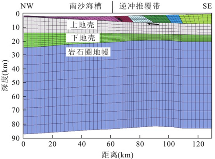
In order to study the lithospheric thermodynamic properties of Nansha trough foreland basin, we simulate the deep lithosphere temperature field and rheological structure during the thrust faults tectonic activities from Middle Miocene to Holocene and after thrusting (static) in the basin using the finite element method, based on previous studies of geological and geophysical data together with a variety of rock thermodynamic parameters.Simulation results indicate that heat flow contribution from mantle reaches 60%-70% of surface heat flow which is controlled by deep mantle in Nansha trough foreland basin.Thrusting movements increase the surface heat flow in thrust-slip fault belts by 15%-25% to 70-75 mW/m2.Our results also show that the temperature of sedimentary layer is less than 200 ℃, while the temperature at Moho varies from 420 to 500 ℃; crust geothermal gradient ranges from 25 to 30 ℃/km.And calculated thickness of thermal lithosphere is about 80 km, which varies slightly laterally.The lithosphere in Nansha waters shows obvious rheological stratification properties, as a typical "sandwich" structure.Horizontally, lithosphere strength decreases in the direction from Nansha trough to thrust belt (NW to SE).The thickness of mechanical lithosphere is about 50 km and the effective elastic thickness ranges from 30 to 32 km.The simulated thermal lithosphere rheological structure also reveals that lithosphere of Nansha basin has rheological characteristics of strong mantle and weak crust, acting as high-strength block.Earthquake activities of Nansha waters are closely related to thermal structure, thermal activity and integrated strength of lithosphere.The weak thermal activity in the crust and high lithosphere strength may be important reasons for rare earthquake occurrence in this area.


2011, 36(5): 949-955.
doi: 10.3799/dqkx.2011.100
Abstract:
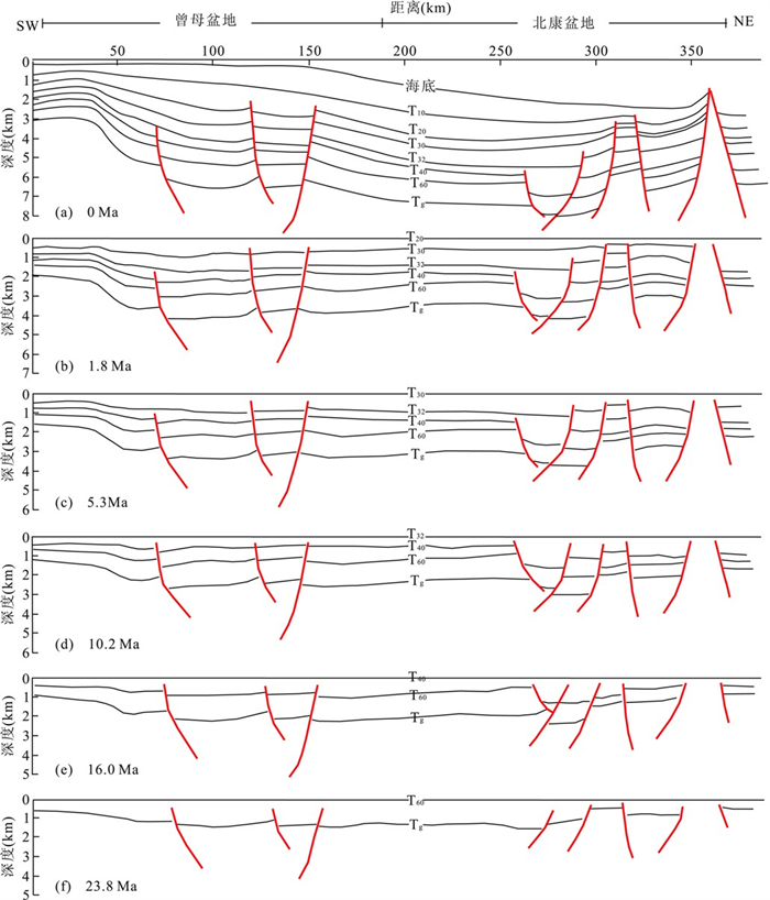
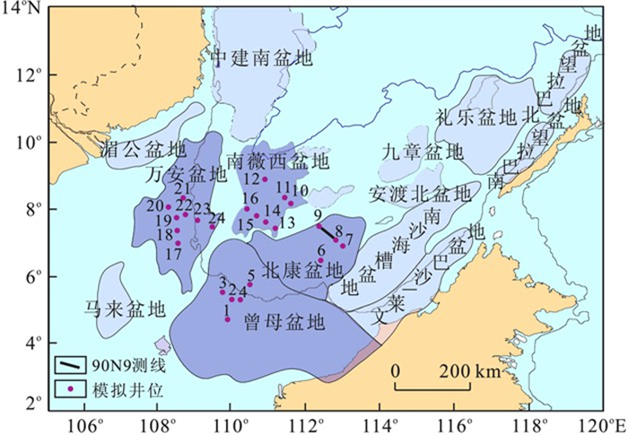
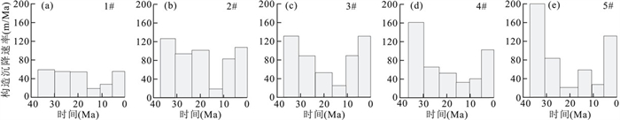
Tectonic subsidence histories of Zengmu basin, Beikang basin, Nanweixi basin and Wan'an basin in Nansha area are analyzed with back-stripping technique.1D tectonic subsidence histories of 24 presumed wells are calculated.The results show that Nansha area experienced 3 main subsiding stages in Cenozoic: (1) Nansha area experienced rifting stage in 40.5—30.0 Ma with a wide range of subsidence.In the first subsiding stage, the max tectonic subsidence rate is 160 m/Ma, which was supposed to be controlled by Xiwei movement. (2) In the second stage (30.0—10.2 Ma), Nansha area ended rifting stage and shifted to depression stage in connection with collision between ancient South China Sea and Borneo.The max tectonic subsidence rate decreased to 20—50 m/Ma. (3) For the third stage (10.2—0 Ma), the regional basins experienced a stage of accelerated subsidence in connection with Nasha movement since Late Miocene.Nansha area experienced regional subsiding stage.
Tectonic subsidence histories of Zengmu basin, Beikang basin, Nanweixi basin and Wan'an basin in Nansha area are analyzed with back-stripping technique.1D tectonic subsidence histories of 24 presumed wells are calculated.The results show that Nansha area experienced 3 main subsiding stages in Cenozoic: (1) Nansha area experienced rifting stage in 40.5—30.0 Ma with a wide range of subsidence.In the first subsiding stage, the max tectonic subsidence rate is 160 m/Ma, which was supposed to be controlled by Xiwei movement. (2) In the second stage (30.0—10.2 Ma), Nansha area ended rifting stage and shifted to depression stage in connection with collision between ancient South China Sea and Borneo.The max tectonic subsidence rate decreased to 20—50 m/Ma. (3) For the third stage (10.2—0 Ma), the regional basins experienced a stage of accelerated subsidence in connection with Nasha movement since Late Miocene.Nansha area experienced regional subsiding stage.


2011, 36(5): 956-966.
doi: 10.3799/dqkx.2011.101
Abstract:
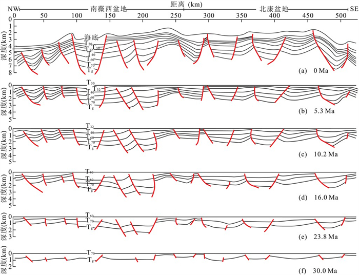
Nansha Sea area lies between extinct paleo-South China Sea and newly-formed South China Sea (SCS) and its relevant researches are of great importance for understanding the mechanisms of rifting in northern SCS continental margin, seafloor spreading in the new SCS, and southward subduction of the paleo-SCS.This paper studies the Cenozoic tectonics and basin evolution in the area by utilizing balanced section.It is suggested that the Cenozoic tectonics in this area have evident zonality features demonstrated by different dominating factors and tectonic activity stages in the three blocks separated by major faults.The tectonic activities of Nansha block are dominated by NW-striking stress, and are divided into an extension-and compression stage by Mid-Late Miocene.Wan'an basin is controlled by Wan'an Fault, and shows no significant stage feature.Zengmu block displays overall similar tectonic activity characteristics and some differences from Nansha block.Based on these results, evolution of major basin in this area is divided into four stages: rifting-, syn-sediment-, compressing-, and regional subsidence stage.However, evolution differs in different basins: Beikang basin is prominent in the rifting and compressing stage, and is lack of regional subsidence stage; Nanweixi basin rifts strongly in the north and is relatively weak in the south; Wan'an basin is lack of compressing stage; Zengmu basin shows evident four-stage feature.
Nansha Sea area lies between extinct paleo-South China Sea and newly-formed South China Sea (SCS) and its relevant researches are of great importance for understanding the mechanisms of rifting in northern SCS continental margin, seafloor spreading in the new SCS, and southward subduction of the paleo-SCS.This paper studies the Cenozoic tectonics and basin evolution in the area by utilizing balanced section.It is suggested that the Cenozoic tectonics in this area have evident zonality features demonstrated by different dominating factors and tectonic activity stages in the three blocks separated by major faults.The tectonic activities of Nansha block are dominated by NW-striking stress, and are divided into an extension-and compression stage by Mid-Late Miocene.Wan'an basin is controlled by Wan'an Fault, and shows no significant stage feature.Zengmu block displays overall similar tectonic activity characteristics and some differences from Nansha block.Based on these results, evolution of major basin in this area is divided into four stages: rifting-, syn-sediment-, compressing-, and regional subsidence stage.However, evolution differs in different basins: Beikang basin is prominent in the rifting and compressing stage, and is lack of regional subsidence stage; Nanweixi basin rifts strongly in the north and is relatively weak in the south; Wan'an basin is lack of compressing stage; Zengmu basin shows evident four-stage feature.