2011 Vol. 36, No. 6
Display Method:
2011, 36(6): 967-976.
doi: 10.3799/dqkx.2011.102
 PDF 9576KB
Abstract:
Based on the data of shallow seismic survey and drilling geological profiles, a buried fault has been found. With eight shallow seismic profiles, it is found that the buried fault is 600m to 1200m apart from the front of Yuwangshan in front of Yuwangshan Mountain, cutting the floor of Daxie basin, likely extending into Quaternary strata at the basin bottom. Using OSL dating and sporo-pollen analysis, we study the Quaternary sediment in the bore holes of Qianjia village, and suggest that the Quaternary sediment is late Pleistocene stratum at western margin in Daxie basin. On the composite drilling geological section in Qianjia village, fault fracture zone is 8.5m in width in Jurassic tuff. On the drilling geological section of Liangnan village, we find two faults in Jurassic tuff, one of which is 5m in width. At the depth of 35m in Liangnan DQZK6 drilling hole, fault plane obliquity is 70° in clay, with its slickenside approximately upright. In Qianjia QJZK8 bore hole, fault plane obliquity is also 70° at depth of 35m in clay. Active rate of the fault is 0.034-0.046mm/a in vertical direction, and it is a weak active fault in early period of late Pleistocene. From the exploration result, we obtain the depth of the upper break point of the buried fault as 35m in the front of Yuwang Mountain. The active fault will not directly destroy buildings on ground surface along the fault zone.
Based on the data of shallow seismic survey and drilling geological profiles, a buried fault has been found. With eight shallow seismic profiles, it is found that the buried fault is 600m to 1200m apart from the front of Yuwangshan in front of Yuwangshan Mountain, cutting the floor of Daxie basin, likely extending into Quaternary strata at the basin bottom. Using OSL dating and sporo-pollen analysis, we study the Quaternary sediment in the bore holes of Qianjia village, and suggest that the Quaternary sediment is late Pleistocene stratum at western margin in Daxie basin. On the composite drilling geological section in Qianjia village, fault fracture zone is 8.5m in width in Jurassic tuff. On the drilling geological section of Liangnan village, we find two faults in Jurassic tuff, one of which is 5m in width. At the depth of 35m in Liangnan DQZK6 drilling hole, fault plane obliquity is 70° in clay, with its slickenside approximately upright. In Qianjia QJZK8 bore hole, fault plane obliquity is also 70° at depth of 35m in clay. Active rate of the fault is 0.034-0.046mm/a in vertical direction, and it is a weak active fault in early period of late Pleistocene. From the exploration result, we obtain the depth of the upper break point of the buried fault as 35m in the front of Yuwang Mountain. The active fault will not directly destroy buildings on ground surface along the fault zone.


2011, 36(6): 977-984.
doi: 10.3799/dqkx.2011.103
Abstract:
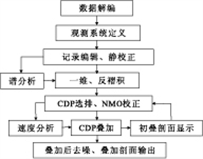
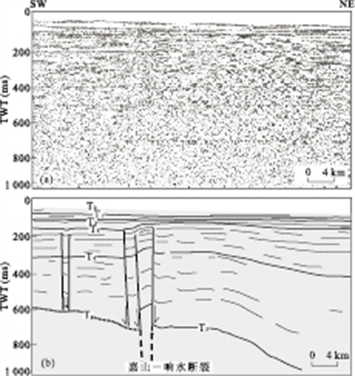
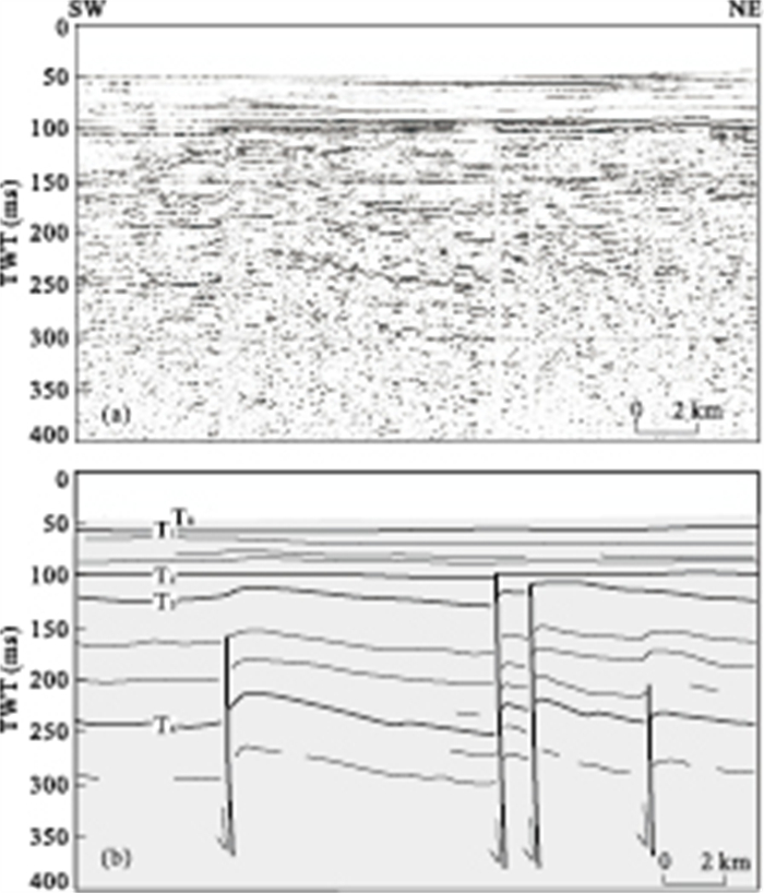
Many Quaternary folds and faults are identified on the seismic reflection profiles acquired in the adjacent areas of Qianliyan Island of southern Yellow Sea. The faults are mainly of reverse fault. The folds are mainly gentle and tilted, caused by fault activities. Most folds and faults occurred below a plane of unconformity between middle Pleistocene and its overlying upper Pleistocene. Some faults, such as Qianliyan fault, are late Pleistocene active fault. Many faults and folds were synsedimentarily developed in the lower Pleistocene and underlying strata, revealling rather strong tectonic activity, especially at the basin boundary where the faults even cut into the late Pleistocene stratum. The formation of folds and faults was attributed to the last tectogenesis of the Yellow Sea in middle Pleistocene, which maybe correspond to the Kunlun-Huanghe movement of Qinghai-Tibet plateau. At that time, the N-S striking horizontal stress drove the early-developed basin boundary faults reactive and further induced the NEE or E-W striking tectonic deformation in the overlying sedimentary layer.
Many Quaternary folds and faults are identified on the seismic reflection profiles acquired in the adjacent areas of Qianliyan Island of southern Yellow Sea. The faults are mainly of reverse fault. The folds are mainly gentle and tilted, caused by fault activities. Most folds and faults occurred below a plane of unconformity between middle Pleistocene and its overlying upper Pleistocene. Some faults, such as Qianliyan fault, are late Pleistocene active fault. Many faults and folds were synsedimentarily developed in the lower Pleistocene and underlying strata, revealling rather strong tectonic activity, especially at the basin boundary where the faults even cut into the late Pleistocene stratum. The formation of folds and faults was attributed to the last tectogenesis of the Yellow Sea in middle Pleistocene, which maybe correspond to the Kunlun-Huanghe movement of Qinghai-Tibet plateau. At that time, the N-S striking horizontal stress drove the early-developed basin boundary faults reactive and further induced the NEE or E-W striking tectonic deformation in the overlying sedimentary layer.


2011, 36(6): 985-992.
doi: 10.3799/dqkx.2011.104
Abstract:
Our study area from the Fanjing Mountain to the Sangzhi County is a part of the propagation tectonic zone of the Xuefengshan Precambrian basement. Expounding the deformation in the area facilitates not only the understanding of the deformation in and around the Xuefengshan, but also the exploration in the marine strata in the southern China. Complex history of deformation in the area can be divided into two-stage Indosinian deformation and two-stage Yanshanian deformation. Two-stage Indosinian deformation is of NEE-EW- and NE-striking folding or faulting. Two-stage Yanshanian deformation is of NE- and NNE-NS-striking faulting or folding. Based on the structural analysis and the tectonic setting, this paper suggests that Indosinian deformation mechanism is mainly related to closing of Tethys Ocean and scissor-style collision of South China to North China plates; however, Yanshanian deformation mechanism is mainly related to northwestward subduction of Izanaqi plate and Kula-Pacific plate.
Our study area from the Fanjing Mountain to the Sangzhi County is a part of the propagation tectonic zone of the Xuefengshan Precambrian basement. Expounding the deformation in the area facilitates not only the understanding of the deformation in and around the Xuefengshan, but also the exploration in the marine strata in the southern China. Complex history of deformation in the area can be divided into two-stage Indosinian deformation and two-stage Yanshanian deformation. Two-stage Indosinian deformation is of NEE-EW- and NE-striking folding or faulting. Two-stage Yanshanian deformation is of NE- and NNE-NS-striking faulting or folding. Based on the structural analysis and the tectonic setting, this paper suggests that Indosinian deformation mechanism is mainly related to closing of Tethys Ocean and scissor-style collision of South China to North China plates; however, Yanshanian deformation mechanism is mainly related to northwestward subduction of Izanaqi plate and Kula-Pacific plate.


2011, 36(6): 993-998.
doi: 10.3799/dqkx.2011.105
Abstract:
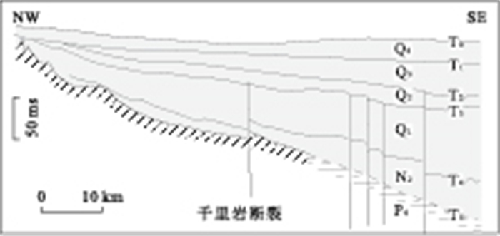
Haiyuan-Liupan Shan area is located in the northeastern margin of present Tibetan plateau. The study of the active structures in this area will provide constraints not only for the seismic evaluation but also for the northeastward growth of the plateau. Based on the geological survey and optically stimulated luminescence (OSL) dating, the timing of the active structures has been determined. The results indicate that active structures occurred in Late Quaternary along the Haiyuan-Liupan Shan and Xiangshan-Tianjing Shan faults, forming the structures such as angular unconformity (planation surface), fold and fault. This suggests that Haiyuan-Liupan Shan area should be considered as a focus of seismic evaluation, and also that the Tibetan plateau grew in its northeast margin in Late Quaternary.
Haiyuan-Liupan Shan area is located in the northeastern margin of present Tibetan plateau. The study of the active structures in this area will provide constraints not only for the seismic evaluation but also for the northeastward growth of the plateau. Based on the geological survey and optically stimulated luminescence (OSL) dating, the timing of the active structures has been determined. The results indicate that active structures occurred in Late Quaternary along the Haiyuan-Liupan Shan and Xiangshan-Tianjing Shan faults, forming the structures such as angular unconformity (planation surface), fold and fault. This suggests that Haiyuan-Liupan Shan area should be considered as a focus of seismic evaluation, and also that the Tibetan plateau grew in its northeast margin in Late Quaternary.


2011, 36(6): 999-1008.
doi: 10.3799/dqkx.2011.106
Abstract:
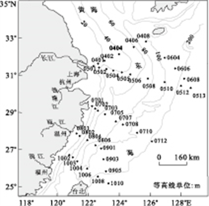
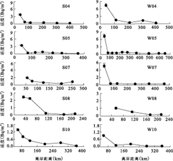
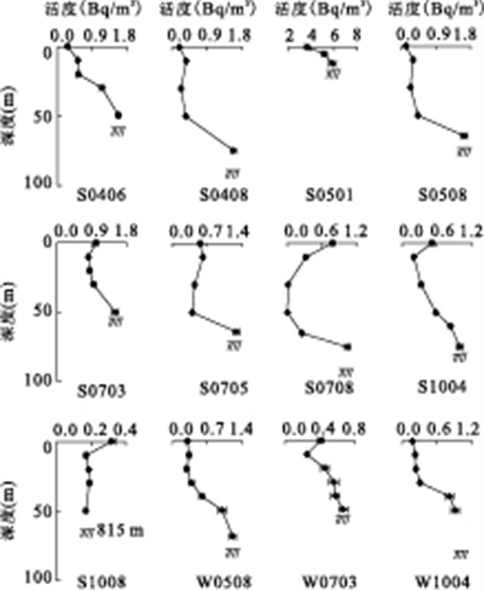
224Ra in the seawater of the East China Sea (ECS) were measured using Mn-fiber adsorption—emanation method. The content level and distribution feature of 224Ra in sea water in summer and winter were studied. The 224Ra activities were < LLD~5.88Bq/m3 with an average of 0.85Bq/m3 in the summer and < LLD~7.50Bq/m3 with an average of 0.72Bq/m3 in the winter. Both seasons 224Ra in the surface water have similar distribution and decreased rapidly with the increasing distance from the coast. The high 224Ra activity at 0.5-7.5Bq/m3 is located within 30-100km offshore and the lowest activity at < 0.13Bq/m3 was in the Kuroshio Current. The 224Ra concentrations in the middle shelf are 0.13-0.5Bq/m3. The vertical distributions showed two different characteristics. The horizontal and vertical eddy diffusion coefficients calculated by the one-dimensional state model of 224Ra were (7.1-88.9)×106cm2/s and 2.18-163cm2/s, respectively. The upwelling rates off Zhejiang were calculated using 224Ra vertical distribution, which varied between (8.4-13.3)×10-3cm/s in the summer and (16.3-16.8)×10-3cm/s in the winter.
224Ra in the seawater of the East China Sea (ECS) were measured using Mn-fiber adsorption—emanation method. The content level and distribution feature of 224Ra in sea water in summer and winter were studied. The 224Ra activities were < LLD~5.88Bq/m3 with an average of 0.85Bq/m3 in the summer and < LLD~7.50Bq/m3 with an average of 0.72Bq/m3 in the winter. Both seasons 224Ra in the surface water have similar distribution and decreased rapidly with the increasing distance from the coast. The high 224Ra activity at 0.5-7.5Bq/m3 is located within 30-100km offshore and the lowest activity at < 0.13Bq/m3 was in the Kuroshio Current. The 224Ra concentrations in the middle shelf are 0.13-0.5Bq/m3. The vertical distributions showed two different characteristics. The horizontal and vertical eddy diffusion coefficients calculated by the one-dimensional state model of 224Ra were (7.1-88.9)×106cm2/s and 2.18-163cm2/s, respectively. The upwelling rates off Zhejiang were calculated using 224Ra vertical distribution, which varied between (8.4-13.3)×10-3cm/s in the summer and (16.3-16.8)×10-3cm/s in the winter.


2011, 36(6): 1009-1020.
doi: 10.3799/dqkx.2011.107
Abstract:
To better understand the formation of Baolun gold deposit and provide information for further exploration, fluid inclusions of quartz in gold-bearing quartz veins were investigated using Raman method. Our results showed that there were mainly two types of inclusion, i. e., CO2-H2O and H2O, respectively. The former contained mainly CO2, with minor CH4, formed in the mineralization stage of gold-bearing quartz veins and gold multi-metal sulfide veins. These inclusions occurred in isolation or group with varied volume, and were the primary inclusion, exhibiting the characteristics of immiscible fluid inclusion. The later occurred mainly in quantz-calcite veins, containing pure H2O. The results of micro-thermometric measurement showed that the homogenization temperatures of mineralization periods Ⅰ and Ⅱ were 248-376℃ and 213-320℃, respectively. The homogenization temperature of the post-mineralization period fluid inclusion was 140-244℃. Ore-forming fluid was the CO2-H2O-NaCl hydrothermal system, mineralization periods Ⅰ and Ⅱ were dominantly mid-low salinities (0.8%-16.05% NaCl equiv) and rich in volatile component (density 0.21-0.85g/cm3). Temperature, salinity, and CO2 concentration all decreased in the late mineralization period. The calcite δ13C(PBD, ‰) and δ18O(PBD, ‰) values of the late stage veins were -6.86 to -13.14 and -10.64 to -14.51, respectively, indicating a magma origin in combination with fluid-rock reactions and organic mixing from the country rocks during the migration and transportation processes. Immiscibility due to water/rock reactions and decrease in fluid temperature and pressure was probably responsible for the gold deposition.
To better understand the formation of Baolun gold deposit and provide information for further exploration, fluid inclusions of quartz in gold-bearing quartz veins were investigated using Raman method. Our results showed that there were mainly two types of inclusion, i. e., CO2-H2O and H2O, respectively. The former contained mainly CO2, with minor CH4, formed in the mineralization stage of gold-bearing quartz veins and gold multi-metal sulfide veins. These inclusions occurred in isolation or group with varied volume, and were the primary inclusion, exhibiting the characteristics of immiscible fluid inclusion. The later occurred mainly in quantz-calcite veins, containing pure H2O. The results of micro-thermometric measurement showed that the homogenization temperatures of mineralization periods Ⅰ and Ⅱ were 248-376℃ and 213-320℃, respectively. The homogenization temperature of the post-mineralization period fluid inclusion was 140-244℃. Ore-forming fluid was the CO2-H2O-NaCl hydrothermal system, mineralization periods Ⅰ and Ⅱ were dominantly mid-low salinities (0.8%-16.05% NaCl equiv) and rich in volatile component (density 0.21-0.85g/cm3). Temperature, salinity, and CO2 concentration all decreased in the late mineralization period. The calcite δ13C(PBD, ‰) and δ18O(PBD, ‰) values of the late stage veins were -6.86 to -13.14 and -10.64 to -14.51, respectively, indicating a magma origin in combination with fluid-rock reactions and organic mixing from the country rocks during the migration and transportation processes. Immiscibility due to water/rock reactions and decrease in fluid temperature and pressure was probably responsible for the gold deposition.


2011, 36(6): 1021-1032.
doi: 10.3799/dqkx.2011.108
Abstract:
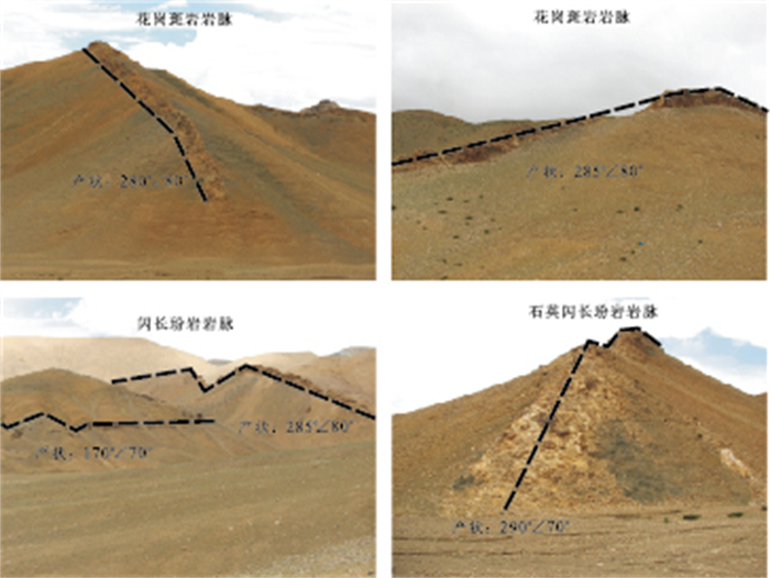
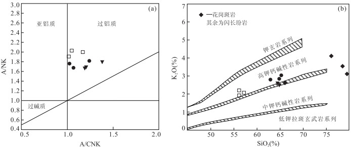
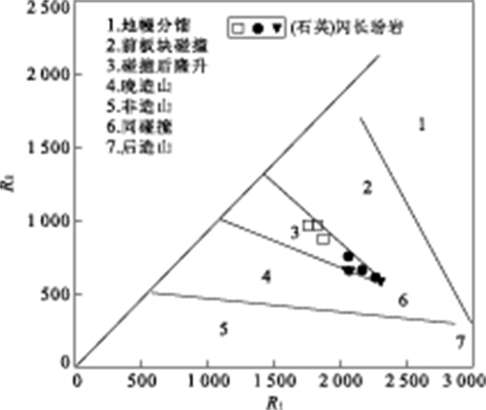
A series of NS-and EW-striking dykes occur in Bangong lake region, western segment of the Bangong lake-Nujiang suture in Tibetan plateau, including both granite porphyry and diorite porphyrite. Based on petrochemical analyses and zircon U-Pb LA-ICP-MS dating combined with field investigation, the present authors propose that these dykes represent a crustal extension event of the Bangong lake arc zone after the closure of Bangeng lake middle-Tethys oceanic basin. The granite porphyries occuring only in NS-strike and the diorite porphyrites occuring both in NS- and EW-strike respectively yield a weighted mean age of 79.59±0.32Ma (MSWD=1.08) with 13 zircons and (76.9±1.2)Ma (MSWD=2.8) with 6. These results indicate that the crustal extensional process of the Bangong lake arc zone occurring in Late Cretaceous epoch was initialed only in EW-trending and slightly later also in NS-trending. Petrochemically, the two types of the dykes appear arc magmatic features characterized by enrichment of large iron incompatible elements (Rb, U, Th, K, Pb) and depletion of high field strength elements (Nb and Ti) which were attributed to metasomatism of Indian-MORB mantle by subducted sediment melt. Furthermore, by analyzing geochemical characteristics of the dyke, we come to the conclusion that the granite porphyries were generated at a shallower depth under amphibolite facies conditions, and the diorite porphyrites were probably under eclogite facies or garnet amphibolite conditions. And the amount of sediment melt involved in the mantle metasomatism related to diorite porphyrites varies largely from 1% to 10% with a source partial melting degree ranging from 8% to 15%. Whereas in the granite porphyries, the amount varies from 10% to 15% and their source partial melting degree is up to 15%.
A series of NS-and EW-striking dykes occur in Bangong lake region, western segment of the Bangong lake-Nujiang suture in Tibetan plateau, including both granite porphyry and diorite porphyrite. Based on petrochemical analyses and zircon U-Pb LA-ICP-MS dating combined with field investigation, the present authors propose that these dykes represent a crustal extension event of the Bangong lake arc zone after the closure of Bangeng lake middle-Tethys oceanic basin. The granite porphyries occuring only in NS-strike and the diorite porphyrites occuring both in NS- and EW-strike respectively yield a weighted mean age of 79.59±0.32Ma (MSWD=1.08) with 13 zircons and (76.9±1.2)Ma (MSWD=2.8) with 6. These results indicate that the crustal extensional process of the Bangong lake arc zone occurring in Late Cretaceous epoch was initialed only in EW-trending and slightly later also in NS-trending. Petrochemically, the two types of the dykes appear arc magmatic features characterized by enrichment of large iron incompatible elements (Rb, U, Th, K, Pb) and depletion of high field strength elements (Nb and Ti) which were attributed to metasomatism of Indian-MORB mantle by subducted sediment melt. Furthermore, by analyzing geochemical characteristics of the dyke, we come to the conclusion that the granite porphyries were generated at a shallower depth under amphibolite facies conditions, and the diorite porphyrites were probably under eclogite facies or garnet amphibolite conditions. And the amount of sediment melt involved in the mantle metasomatism related to diorite porphyrites varies largely from 1% to 10% with a source partial melting degree ranging from 8% to 15%. Whereas in the granite porphyries, the amount varies from 10% to 15% and their source partial melting degree is up to 15%.


2011, 36(6): 1033-1043.
doi: 10.3799/dqkx.2011.109
Abstract:
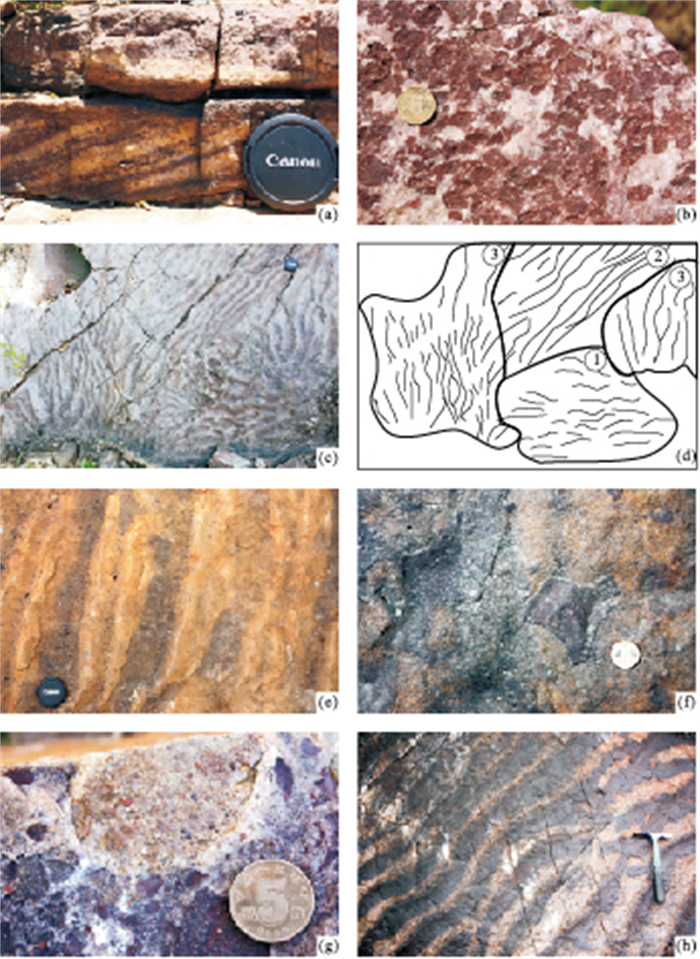
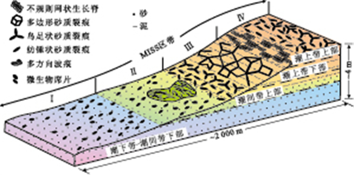
Microbially induced sedimentary structures (MISS) are derived from the interaction of microbes and sedimentation by various geological processes, and have been studied more often as biosignature for early life, while their significance in paleoenvironmental analysis has not been adequately studied yet. Our study shows that the Ruyang (Pt2) and Luoyu Groups (Pt3) in the southern North China Platform are dominated by peritidal silisiclastics with abundant MISS, especially those related with mat destruction, and indicates that the morphologic variation and association of MISS are largely influenced by topography. The topography, to some extent, determines the hydrodynamics, substrate exposure duration and water supplement, and exerts influence on mat growth and their destruction, and in turn influence the morphology of MISS, especially in peritidal environments. From the subtidal to supratidal, four zones have been recognized, each of them with its own distinctiveness in MISS morphological association. The subtidal to lower intertidal zone is short of in situ MISS but has some redeposited mat chips, while the upper intertidal is featured by mat protected ripple marks and chips. The lower supertidal is rich in various MISS, especially sand cracks, for its low hydrodynamics, sufficient water supplement and frequently exposed environment, with thick mats, while the upper supertidal abounds smaller sand cracks than those in lower supertidal zone due to relatively thin microbial mats. Thus, Meso- to Neo-proterozoic MISS from the southern North China Platform show that the morphologic association of MISS can be used as good indicators for paleoenvironmental reconstruction.
Microbially induced sedimentary structures (MISS) are derived from the interaction of microbes and sedimentation by various geological processes, and have been studied more often as biosignature for early life, while their significance in paleoenvironmental analysis has not been adequately studied yet. Our study shows that the Ruyang (Pt2) and Luoyu Groups (Pt3) in the southern North China Platform are dominated by peritidal silisiclastics with abundant MISS, especially those related with mat destruction, and indicates that the morphologic variation and association of MISS are largely influenced by topography. The topography, to some extent, determines the hydrodynamics, substrate exposure duration and water supplement, and exerts influence on mat growth and their destruction, and in turn influence the morphology of MISS, especially in peritidal environments. From the subtidal to supratidal, four zones have been recognized, each of them with its own distinctiveness in MISS morphological association. The subtidal to lower intertidal zone is short of in situ MISS but has some redeposited mat chips, while the upper intertidal is featured by mat protected ripple marks and chips. The lower supertidal is rich in various MISS, especially sand cracks, for its low hydrodynamics, sufficient water supplement and frequently exposed environment, with thick mats, while the upper supertidal abounds smaller sand cracks than those in lower supertidal zone due to relatively thin microbial mats. Thus, Meso- to Neo-proterozoic MISS from the southern North China Platform show that the morphologic association of MISS can be used as good indicators for paleoenvironmental reconstruction.


2011, 36(6): 1044-1052.
doi: 10.3799/dqkx.2011.110
Abstract:
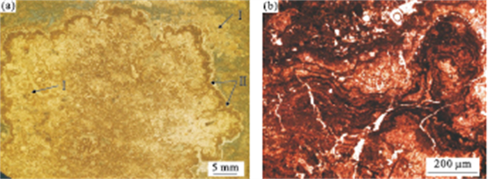
Most fossil reefs found so far are preserved in marine sediments with high biodiversity of reef-building organisms and recognized as implication for shallow normal marine environment. However, lacustrine reefs are relatively scarce and usually constructed by low biodiversity but high abundance of reef associated fossils, implying specialized water conditions. The frame of Paleogene lacustrine reefs in Dongying depression of Shandong Province were constructed mainly by Cladosiphonia and bound by Cyanobacteria. Reef-dwelling organisms are of great abundance though only a few species are involved, such as ostracodes, micro-gastropods and spirorbis, which belong to euryhaline organisms. Large amount of fibrous calcite cement was formed as the product of early diagenesis around the Cladosiphonia, reinforcing the solidity of reef structure. Early diagenesis cement widely formed in the reef structure suggests high saturation of lacustrine chemistry for carbonate precipitation. Paleogene is a special stage in geologic history, during which different types of evaporates were deposited all over the world. Paleogene Cladosiphonia-build reefs in Dongying depression should have been formed under arid climate conditions. Cladosiphonia-build reefs undoubtedly facilitates the understanding of the palaeoecology of ancient lacustrine and the condition of paleoclimate, and is of great importance to the study of petroleum reservoir as well.
Most fossil reefs found so far are preserved in marine sediments with high biodiversity of reef-building organisms and recognized as implication for shallow normal marine environment. However, lacustrine reefs are relatively scarce and usually constructed by low biodiversity but high abundance of reef associated fossils, implying specialized water conditions. The frame of Paleogene lacustrine reefs in Dongying depression of Shandong Province were constructed mainly by Cladosiphonia and bound by Cyanobacteria. Reef-dwelling organisms are of great abundance though only a few species are involved, such as ostracodes, micro-gastropods and spirorbis, which belong to euryhaline organisms. Large amount of fibrous calcite cement was formed as the product of early diagenesis around the Cladosiphonia, reinforcing the solidity of reef structure. Early diagenesis cement widely formed in the reef structure suggests high saturation of lacustrine chemistry for carbonate precipitation. Paleogene is a special stage in geologic history, during which different types of evaporates were deposited all over the world. Paleogene Cladosiphonia-build reefs in Dongying depression should have been formed under arid climate conditions. Cladosiphonia-build reefs undoubtedly facilitates the understanding of the palaeoecology of ancient lacustrine and the condition of paleoclimate, and is of great importance to the study of petroleum reservoir as well.


2011, 36(6): 1053-1063.
doi: 10.3799/dqkx.2011.111
Abstract:
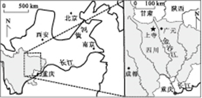
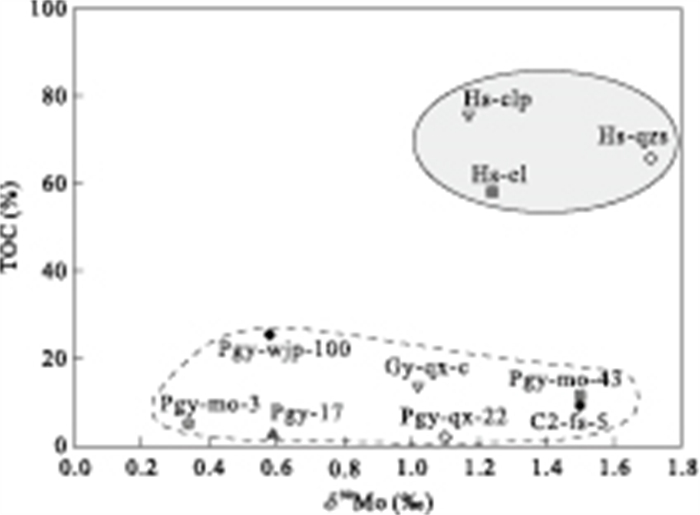
In this research, new Molybdenum isotopic compositions of the bitumen, in the Gaungyuan section, Sichuan, as well as trace elements are determined. The results show that it has a large variation of δ98Mo (+0.34‰~+1.71‰) in this region, reaching the range of anoxic sediments δ98Mo in general. The slightly positive δEu anomaly has been shown in the Cambrian interval (0.75-1.68), specially, with a sample from Qiongzhusi Formation (Hs-qzs) with a significant positive δEu anomaly (1.68), corresponding to the enrichment of redox-sensitive trace elements (such as Mo, Ni, V), with the positive δ98Mo (1.17‰-1.71‰). These characteristics might be related to local intense hydrothermal erupting, corresponding to the large quantity of H2S and HS- into the contemporaneous seawater. Introduction of these sulfide gases would cause MoO42- to be transferred into MoS42-, favoring the preferential deposition of the heavy Mo isotope as MoS42- and thus leaving a positive Mo isotope value. Although no much good correlation between TMV and TMNi has been shown in this area, the distinct fields from difference interval of bitumen is observed by the plot of δ98Mo against V/Ni ratios, it implies the possible stability of δ98Mo by local mobilization during diagenesis/early catagenesis.
In this research, new Molybdenum isotopic compositions of the bitumen, in the Gaungyuan section, Sichuan, as well as trace elements are determined. The results show that it has a large variation of δ98Mo (+0.34‰~+1.71‰) in this region, reaching the range of anoxic sediments δ98Mo in general. The slightly positive δEu anomaly has been shown in the Cambrian interval (0.75-1.68), specially, with a sample from Qiongzhusi Formation (Hs-qzs) with a significant positive δEu anomaly (1.68), corresponding to the enrichment of redox-sensitive trace elements (such as Mo, Ni, V), with the positive δ98Mo (1.17‰-1.71‰). These characteristics might be related to local intense hydrothermal erupting, corresponding to the large quantity of H2S and HS- into the contemporaneous seawater. Introduction of these sulfide gases would cause MoO42- to be transferred into MoS42-, favoring the preferential deposition of the heavy Mo isotope as MoS42- and thus leaving a positive Mo isotope value. Although no much good correlation between TMV and TMNi has been shown in this area, the distinct fields from difference interval of bitumen is observed by the plot of δ98Mo against V/Ni ratios, it implies the possible stability of δ98Mo by local mobilization during diagenesis/early catagenesis.


2011, 36(6): 1064-1072.
doi: 10.3799/dqkx.2011.112
Abstract:
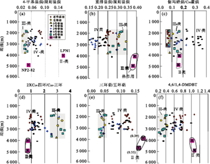
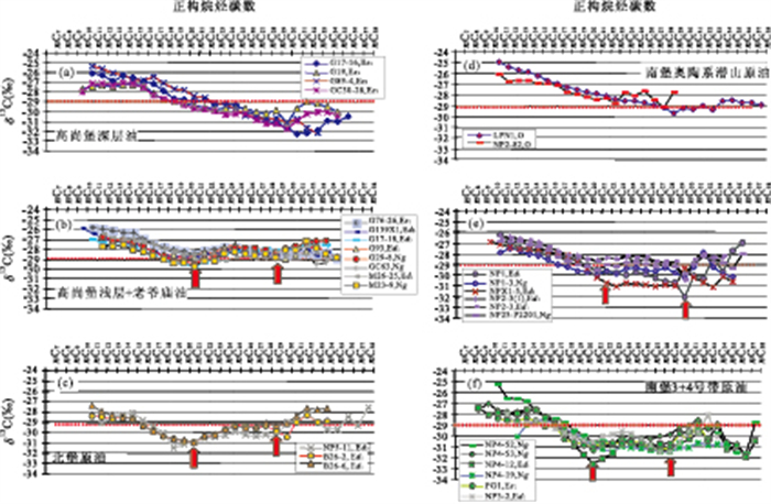
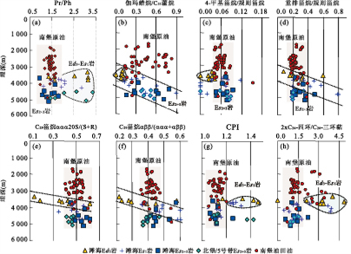
The origin of the hydrocarbons in the Napu depression is still not clear. Compound specific carbon isotope of n-alkanes has been utilized, combined with biomarkers to carry out detail geochemical investigations for the oils and source rocks within the whole depression for the first time. The results show that the Tertiary Es3 rocks (type-Ⅰ) in the Shichang sub-depression are characterized by abundant 4-methyl steranes and dibenzothiophenes but low concentration of gammacerane with a "tilted linear" shape of compound specific carbon isotope distribution. The type-Ⅰ genetic related oil has been discovered in the Tertiary Es3 interval of Gaoshangpu and Liuzan oilfields. The Tertiary Es2+3 rock (type-Ⅱ) in the south Nanpu depression is featured by a relatively high content of gammacerane while little 4-methyl sterane contained, and it has a similar carbon isotope curve and dibenzothiophene concentration to that of the type-Ⅰ rock. The type-Ⅱ genetic oil has been discovered in the Ordovician burial hills. The Tertiary Es1-Ed3 rock (Ⅲ) in the Nanpu depression is distinguished from the others by obviously high content of diasteranes and pregnant series with a relatively lowerδ13C of n-alkane and nearly a "W" shape of carbon isotopic pattern. The type-Ⅲ genetic related oils was discovered in the NP4, 5 tectonic belts. It is observed that the oils in the NP1, 2 tectonic belts, Laoyemiao oilfield and the Tertiary Nm-Es1 of Gaoshangpu and Liuzan oilfield have intermediate biomarker and isotope characteristics between the type-Ⅱ and type-Ⅲ source rocks and the related oils, indicating mixed sources of the oils derived from both the type-Ⅱ and type-Ⅲ rocks. It is found that the related contribution of the Es2+3 source rocks to the mixed oils is up to 82%. We suggest that the Es2+3 is an important set of source rock in the Nanpu depression, responsible for most of the oils. This result is different from the previous ones that most of the oils in the Nanpu depression were derived from the Es1-Ed3 source rocks rather than the Es2+3, which provides essential information for further petroleum exploration of the depression.
The origin of the hydrocarbons in the Napu depression is still not clear. Compound specific carbon isotope of n-alkanes has been utilized, combined with biomarkers to carry out detail geochemical investigations for the oils and source rocks within the whole depression for the first time. The results show that the Tertiary Es3 rocks (type-Ⅰ) in the Shichang sub-depression are characterized by abundant 4-methyl steranes and dibenzothiophenes but low concentration of gammacerane with a "tilted linear" shape of compound specific carbon isotope distribution. The type-Ⅰ genetic related oil has been discovered in the Tertiary Es3 interval of Gaoshangpu and Liuzan oilfields. The Tertiary Es2+3 rock (type-Ⅱ) in the south Nanpu depression is featured by a relatively high content of gammacerane while little 4-methyl sterane contained, and it has a similar carbon isotope curve and dibenzothiophene concentration to that of the type-Ⅰ rock. The type-Ⅱ genetic oil has been discovered in the Ordovician burial hills. The Tertiary Es1-Ed3 rock (Ⅲ) in the Nanpu depression is distinguished from the others by obviously high content of diasteranes and pregnant series with a relatively lowerδ13C of n-alkane and nearly a "W" shape of carbon isotopic pattern. The type-Ⅲ genetic related oils was discovered in the NP4, 5 tectonic belts. It is observed that the oils in the NP1, 2 tectonic belts, Laoyemiao oilfield and the Tertiary Nm-Es1 of Gaoshangpu and Liuzan oilfield have intermediate biomarker and isotope characteristics between the type-Ⅱ and type-Ⅲ source rocks and the related oils, indicating mixed sources of the oils derived from both the type-Ⅱ and type-Ⅲ rocks. It is found that the related contribution of the Es2+3 source rocks to the mixed oils is up to 82%. We suggest that the Es2+3 is an important set of source rock in the Nanpu depression, responsible for most of the oils. This result is different from the previous ones that most of the oils in the Nanpu depression were derived from the Es1-Ed3 source rocks rather than the Es2+3, which provides essential information for further petroleum exploration of the depression.


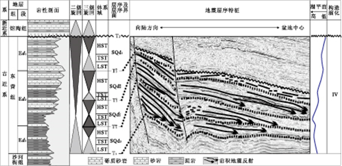
2011, 36(6): 1073-1084.
doi: 10.3799/dqkx.2011.113
Abstract:
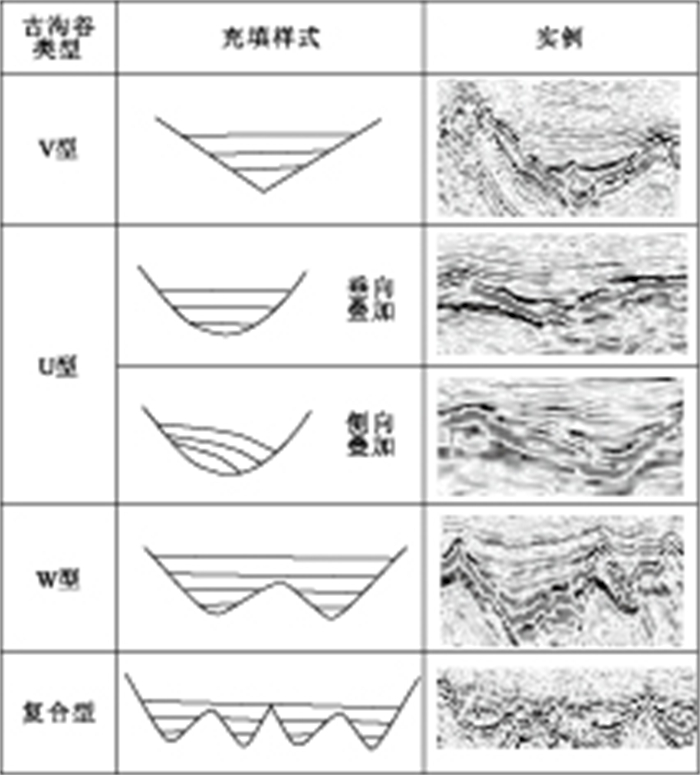
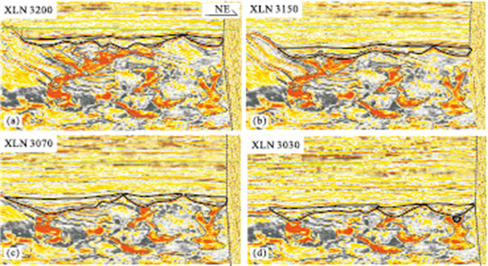
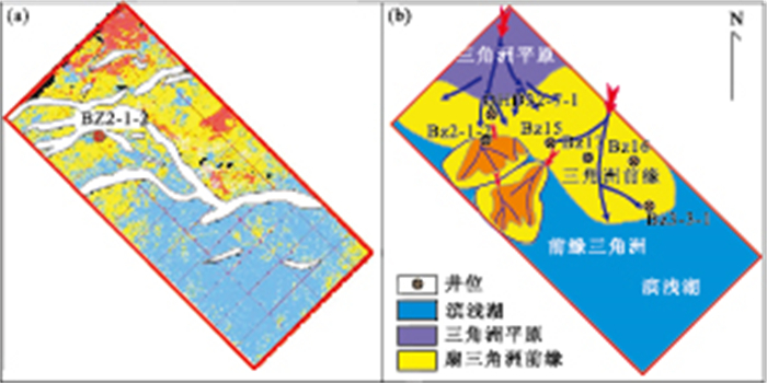
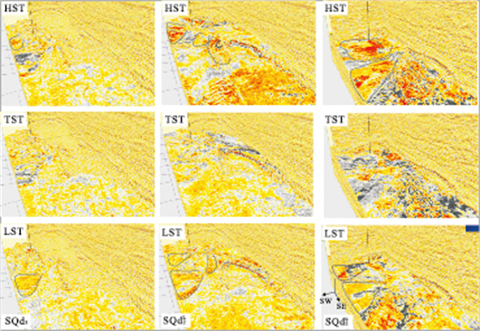
Based on sequence stratigraphy, seismic sedimentology theory and 3D visualization technology, High resolution three-dimensional facies architecture was described in detail using the recent 3D seismic data of Dongying Formation of BZ3-1 Block, western slope of Bozhong sag. The paleo-channels of Dongying formation could be subdivided into four types including type V, U, W and Compound, and were delineated the branching and converging infilling characteristics from up-stream to down-stream and the evolution stage from occurrence to extinction. Normally, Fan-shaped abnormal areas of seismic multi-attributes were located in the footwall of faults. On the basis of an integrated analysis of well log and core data, seismic facies, seismic multi-attribute, the sedimentary facies of sequences of Dongying formation were found to include fan-delta, braided river delta and coast-shallow lake, and the boundaries of these facies were crystallized quantitatively. The results of high resolution three-dimensional sedimentary systems analysis show that the third-order sequence located in different system tracts of second-order sequence could be lead to their system tracts with the different sedimentary types and scale. Because sequence SQd3 belong to the lowstand system tracts of second-order sequence, and the fan scale of lowstand system tracts of sequence SQd3 was larger than that of its highstand system tracts'; Sequence SQd2L is located in the transgressve system tracts of second-order sequence, and the delta scale of lowstand system tracts of sequence SQd2L was equal to that of its highstand system tracts'; Sequence SQd2u developed in the highstand system tracts of second-order sequence, and the delta scale of lowstand system tracts of sequence SQd2L was less than that its highstand system tracts'.
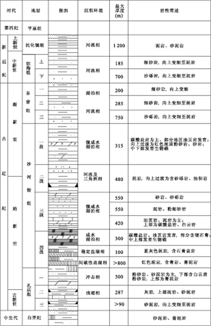
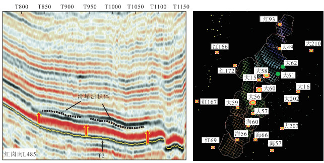
Based on sequence stratigraphy, seismic sedimentology theory and 3D visualization technology, High resolution three-dimensional facies architecture was described in detail using the recent 3D seismic data of Dongying Formation of BZ3-1 Block, western slope of Bozhong sag. The paleo-channels of Dongying formation could be subdivided into four types including type V, U, W and Compound, and were delineated the branching and converging infilling characteristics from up-stream to down-stream and the evolution stage from occurrence to extinction. Normally, Fan-shaped abnormal areas of seismic multi-attributes were located in the footwall of faults. On the basis of an integrated analysis of well log and core data, seismic facies, seismic multi-attribute, the sedimentary facies of sequences of Dongying formation were found to include fan-delta, braided river delta and coast-shallow lake, and the boundaries of these facies were crystallized quantitatively. The results of high resolution three-dimensional sedimentary systems analysis show that the third-order sequence located in different system tracts of second-order sequence could be lead to their system tracts with the different sedimentary types and scale. Because sequence SQd3 belong to the lowstand system tracts of second-order sequence, and the fan scale of lowstand system tracts of sequence SQd3 was larger than that of its highstand system tracts'; Sequence SQd2L is located in the transgressve system tracts of second-order sequence, and the delta scale of lowstand system tracts of sequence SQd2L was equal to that of its highstand system tracts'; Sequence SQd2u developed in the highstand system tracts of second-order sequence, and the delta scale of lowstand system tracts of sequence SQd2L was less than that its highstand system tracts'.


2011, 36(6): 1085-1094.
doi: 10.3799/dqkx.2011.114
Abstract:
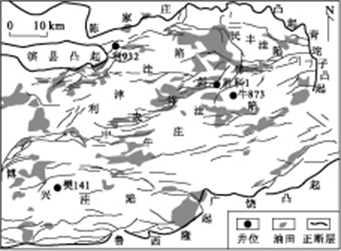
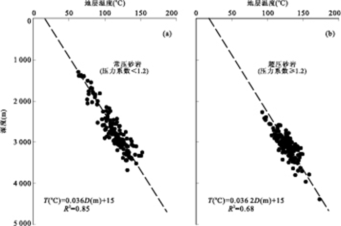
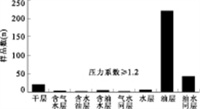
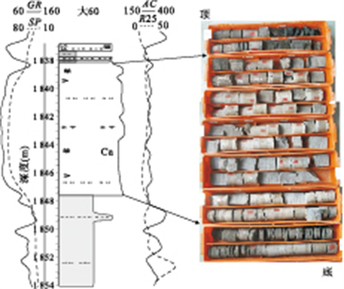
Overpressures are common in the third member and the fourth member of Shahejie (Es3 and Es4) Formations of Dongying depression. The sonic log displays an obvious response to the overpressure from which the overpressured mudstones have higher acoustic travel time and the acoustic travel time of the normally pressured and overpressured mudstones is reduced with increasing vertical effective stress. In this paper, large numbers of well-log, tests and geological data in Dongying depression are used to determine the origin of overpressure. We put forward that the oil generation is the major overpressure mechanism based on the confirmation of that the overpressured sediments are normal compaction. It is supported by the following evidences: (1) The overpressured mudstones exhibit no anomalous low density; (2) There is apparent lack of correlation between mudstone densities and effective vertical stress; (3) The overpressured reservoir sandstones show neither anomalous high matrix porosities nor anomalous geothermal gradient; (4) The depths to the top of the overpressure range from 2000m to 3000m, increasing with the increased source rocks depths and the temperatures for the top of overpressure zones are approximately 87-123℃ corresponding to an estimated vitrinite reflectance (Ro) of 0.5%-0.75%; (5) The overpressured source rocks are still capable of oil generation; (6) There are good conditions for overpressure seals because of the calcareous mudstones; (7) There are large numbers of microfractures in the source rocks; (8) The overpressured reservoirs are predominantly oil saturated or oil-bearing and overpressured water reservoirs are rare. It is concluded that overpressures in the reservoir rocks are generated by the fluid transmission from the overpressured source rocks.
Overpressures are common in the third member and the fourth member of Shahejie (Es3 and Es4) Formations of Dongying depression. The sonic log displays an obvious response to the overpressure from which the overpressured mudstones have higher acoustic travel time and the acoustic travel time of the normally pressured and overpressured mudstones is reduced with increasing vertical effective stress. In this paper, large numbers of well-log, tests and geological data in Dongying depression are used to determine the origin of overpressure. We put forward that the oil generation is the major overpressure mechanism based on the confirmation of that the overpressured sediments are normal compaction. It is supported by the following evidences: (1) The overpressured mudstones exhibit no anomalous low density; (2) There is apparent lack of correlation between mudstone densities and effective vertical stress; (3) The overpressured reservoir sandstones show neither anomalous high matrix porosities nor anomalous geothermal gradient; (4) The depths to the top of the overpressure range from 2000m to 3000m, increasing with the increased source rocks depths and the temperatures for the top of overpressure zones are approximately 87-123℃ corresponding to an estimated vitrinite reflectance (Ro) of 0.5%-0.75%; (5) The overpressured source rocks are still capable of oil generation; (6) There are good conditions for overpressure seals because of the calcareous mudstones; (7) There are large numbers of microfractures in the source rocks; (8) The overpressured reservoirs are predominantly oil saturated or oil-bearing and overpressured water reservoirs are rare. It is concluded that overpressures in the reservoir rocks are generated by the fluid transmission from the overpressured source rocks.


2011, 36(6): 1095-1104.
doi: 10.3799/dqkx.2011.115
Abstract:
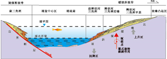
In order to understand the sedimentary characteristics and distribution of the turbidites developed at the gentle slope of depression basins, the upper Cretaceous Qing1 & 2 members at the western slope of South Songliao basin is chosen as the research object. Its sedimentary facies and distribution are studied by investigating the cores, logging data and seismic interpretation. This area mainly developed delta front-fluxoturbidite system, and the fluxoturbidites in the study area which are the oil and gas reservoir can be divided into the following three micro-facies: turbidite channel, turbidite lobe and turbidite sheet sand. Based on the sedimentary facies correlation and distribution analysis, the depositional model of the fluxoturbidites developed on the gentle slope of depression basins was built, which is the linear-source mud/sand turbidites model. Compared with rift basins, the scale of fluxoturbidites developed in depression basins is relatively smaller and the grain size of it is finer because the fault activity of gentle slope in depression basin is very weak and its slope with lower angle. Furthermore, different from the rift basin, fluxoturbidites in depression basin mainly developed in the base level rise phase of 3rd sequence and its accumulation is also closely related to the transgression in the 4th sequence.
In order to understand the sedimentary characteristics and distribution of the turbidites developed at the gentle slope of depression basins, the upper Cretaceous Qing1 & 2 members at the western slope of South Songliao basin is chosen as the research object. Its sedimentary facies and distribution are studied by investigating the cores, logging data and seismic interpretation. This area mainly developed delta front-fluxoturbidite system, and the fluxoturbidites in the study area which are the oil and gas reservoir can be divided into the following three micro-facies: turbidite channel, turbidite lobe and turbidite sheet sand. Based on the sedimentary facies correlation and distribution analysis, the depositional model of the fluxoturbidites developed on the gentle slope of depression basins was built, which is the linear-source mud/sand turbidites model. Compared with rift basins, the scale of fluxoturbidites developed in depression basins is relatively smaller and the grain size of it is finer because the fault activity of gentle slope in depression basin is very weak and its slope with lower angle. Furthermore, different from the rift basin, fluxoturbidites in depression basin mainly developed in the base level rise phase of 3rd sequence and its accumulation is also closely related to the transgression in the 4th sequence.


2011, 36(6): 1105-1118.
doi: 10.3799/dqkx.2011.116
Abstract:
Aiming at Chengdian deep water sandstone in Biyang depression of Nanxiang basin, we analyzed the core, the particle size, thin section, heavy minerals testing materials, structure of sandbody and the geophysical response of sedimentary sandbody, and found that the sub-lacustrine fan is an isolated body with fine and coarse lithology which consists of mainly massive lithologic facies with the characteristics of sandy debris flow sediments, but wavy bedding and cross bedding lithologic facies, two lithologic facies have its own particle-size feature, which shows the feature of turbidity current and tractive current.It's controlled by the paroxysmal flood, the revolving tilted effect and a gentle slope, we define it as a flood cause sub-lacustrine fan of composite transportation. In order to trace its provenance using clastic zircons dating analysis of sandstone samples, we selected samples from Chengdian sub-lacustrine and the Houzhuang delta area. The result shows: zircons microarea apparent ages of Chengdian sub-lacustrine and Houzhuang delta mainly similarly distribute between 115Ma and 166Ma with single peak and the magmatic zircons occupy the main part, with a few metamorphic zircons. Also, there are some different type zircons distributing in the age populations of 247-210Ma, 475-412Ma, 813-663Ma and 3489-1692Ma. In combination with regional geological settings and detritus zircon ages and heavy minerals composition, the authors come to the following preliminary conclusions: the sub-lacustrine sandbody derived from Houzhuang delta and its source rocks formation period is early Cretaceous to middle Jurassic, corresponding to Yanshan tectonic stage. Moreover, the source area is mainly Yanshanian granite in Kuanping-taowan tecnoic rock facies belt, including Yanshanian metamorphic rocks and the metamorphic rocks or magmatic rocks of Prejinningian period, Jinningian period, Caledonian period and Indosinian period may offer contributions to different degree.
Aiming at Chengdian deep water sandstone in Biyang depression of Nanxiang basin, we analyzed the core, the particle size, thin section, heavy minerals testing materials, structure of sandbody and the geophysical response of sedimentary sandbody, and found that the sub-lacustrine fan is an isolated body with fine and coarse lithology which consists of mainly massive lithologic facies with the characteristics of sandy debris flow sediments, but wavy bedding and cross bedding lithologic facies, two lithologic facies have its own particle-size feature, which shows the feature of turbidity current and tractive current.It's controlled by the paroxysmal flood, the revolving tilted effect and a gentle slope, we define it as a flood cause sub-lacustrine fan of composite transportation. In order to trace its provenance using clastic zircons dating analysis of sandstone samples, we selected samples from Chengdian sub-lacustrine and the Houzhuang delta area. The result shows: zircons microarea apparent ages of Chengdian sub-lacustrine and Houzhuang delta mainly similarly distribute between 115Ma and 166Ma with single peak and the magmatic zircons occupy the main part, with a few metamorphic zircons. Also, there are some different type zircons distributing in the age populations of 247-210Ma, 475-412Ma, 813-663Ma and 3489-1692Ma. In combination with regional geological settings and detritus zircon ages and heavy minerals composition, the authors come to the following preliminary conclusions: the sub-lacustrine sandbody derived from Houzhuang delta and its source rocks formation period is early Cretaceous to middle Jurassic, corresponding to Yanshan tectonic stage. Moreover, the source area is mainly Yanshanian granite in Kuanping-taowan tecnoic rock facies belt, including Yanshanian metamorphic rocks and the metamorphic rocks or magmatic rocks of Prejinningian period, Jinningian period, Caledonian period and Indosinian period may offer contributions to different degree.


Characteristics of Fault Cementation Zone and Its Origin in Linpan Oil Pool of the Huimin Depression
2011, 36(6): 1119-1124.
doi: 10.3799/dqkx.2011.117
Abstract:
Fault block oil reservoirs are well developed in Linpan oil pool of the Huimin depression. But the sealing mechanism of fault is not clear. The fault cementation zone characteristics and its origin are discussed by means of core data, well logging data, physical property and scanning electronic microscope analysis. The subsurface water rich in Ca2+ and Mg2+ migrates from deep formation to shallow part along the fault zone during faulting activity in Linpan oil pool. Calcite and dolomite deposit along the fault zone due to the decreasing geothermal pressure upward. As a result, the permeability of the fault zone decreases about one order of magnitude and the accumulated oil is well sealed by fault cementation zone.
Fault block oil reservoirs are well developed in Linpan oil pool of the Huimin depression. But the sealing mechanism of fault is not clear. The fault cementation zone characteristics and its origin are discussed by means of core data, well logging data, physical property and scanning electronic microscope analysis. The subsurface water rich in Ca2+ and Mg2+ migrates from deep formation to shallow part along the fault zone during faulting activity in Linpan oil pool. Calcite and dolomite deposit along the fault zone due to the decreasing geothermal pressure upward. As a result, the permeability of the fault zone decreases about one order of magnitude and the accumulated oil is well sealed by fault cementation zone.


2011, 36(6): 1125-1133.
doi: 10.3799/dqkx.2011.118
Abstract:
It is supposed that we can effectively predict the fracture density in carbonate layer by studying the pattern of vertical fracture development controlled by mechanical stratigraphy. The latitude of stratum is smooth in Ordovician carbonate in Xikeer outcrop area of Xinjiang autonomous region. Opening-mode fractures (joints) that are perpendicular to bedding are typically controlled by mechanical stratigraphy. After computing amounts and analyzing characteristics of vertical fractures in combination with the results of dividing sedimentary cycle in stratum section of Number 21 (latitude 39°50'17.34″N, longitude 77°28'36.12″E), number 32 (latitude 39°50'18.18″N, longitude 77°28'25.62″E) and number 43 (latitude 39°50'10.88″N, longitude 77°28'26.1″E) in researching outcrop area, we identify the distribution characteristics of different mechanical interfaces and based on which we calculate the fracture density controlled by different mechanical units in each section. The average of fracture density of section 21 is 7.1 per meter which is larger than 2.9 per meter of section 43 and 2.2 per meter of section 32. At the same time, we study the dominating factors of fracture density differences in different section from lithological characteristics, thickness of mechanical unit and stress state. It shows that fracture density increases as the content of mudstone is higher in limestone in carbonate stratigraphy and fracture density is sharply lower in grain limestone than that in mudstone. On the other hand, because of the influence of stress shadow, the thickness of mechanical unit has negative correlation with fracture density: the thicker the mechanical unit is, the less the fracture density is. Fracture saturation in section 43 and section 32 is larger than 0.8, which shows they have approached fracture saturated state. However, the section 21 that has the largest fracture density is of unsaturated state, with a fracture saturation of mere 0.6. Therefore, the average fracture has negative correlation with fracture saturation.
It is supposed that we can effectively predict the fracture density in carbonate layer by studying the pattern of vertical fracture development controlled by mechanical stratigraphy. The latitude of stratum is smooth in Ordovician carbonate in Xikeer outcrop area of Xinjiang autonomous region. Opening-mode fractures (joints) that are perpendicular to bedding are typically controlled by mechanical stratigraphy. After computing amounts and analyzing characteristics of vertical fractures in combination with the results of dividing sedimentary cycle in stratum section of Number 21 (latitude 39°50'17.34″N, longitude 77°28'36.12″E), number 32 (latitude 39°50'18.18″N, longitude 77°28'25.62″E) and number 43 (latitude 39°50'10.88″N, longitude 77°28'26.1″E) in researching outcrop area, we identify the distribution characteristics of different mechanical interfaces and based on which we calculate the fracture density controlled by different mechanical units in each section. The average of fracture density of section 21 is 7.1 per meter which is larger than 2.9 per meter of section 43 and 2.2 per meter of section 32. At the same time, we study the dominating factors of fracture density differences in different section from lithological characteristics, thickness of mechanical unit and stress state. It shows that fracture density increases as the content of mudstone is higher in limestone in carbonate stratigraphy and fracture density is sharply lower in grain limestone than that in mudstone. On the other hand, because of the influence of stress shadow, the thickness of mechanical unit has negative correlation with fracture density: the thicker the mechanical unit is, the less the fracture density is. Fracture saturation in section 43 and section 32 is larger than 0.8, which shows they have approached fracture saturated state. However, the section 21 that has the largest fracture density is of unsaturated state, with a fracture saturation of mere 0.6. Therefore, the average fracture has negative correlation with fracture saturation.


2011, 36(6): 1134-1142.
doi: 10.3799/dqkx.2011.119
Abstract:
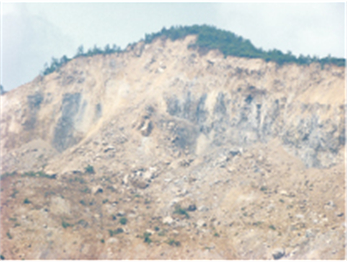
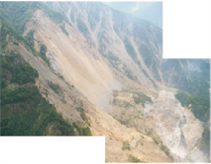
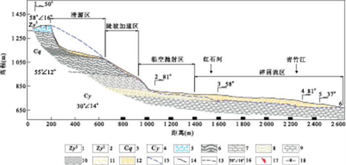
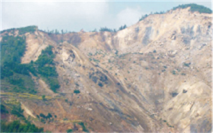
The "5·12" Wenchuan earthquake induced thousands of landslides, including hundreds of large-scale ones. The deformation and destroy characteristics of 20 large-scale landslides induced by Wenchuan earthquake found in our in-depth investigation and extensive survey, combined with the tools of shaking table test and numerical simulation, we find that their deformation and destroy model and intrinsic mechanical mechanism Wenchuan earthquake are significantly different from those of landsides induced by routine gravity. On the condition of strong shock, the earthquake-horizontal acceleration on the middle-top of the declivity can exceed 1g, and its earthquake horizontal inertia enormously exceeds the tension strength of the rock mass. Seismic action firstly shaped a deep large fissure which was parallel to the clinohedron on the back of the slope, and then the bottom of the pull-apart rock mass engendered shearing glide, finally, there induced landslide. On the condition of strong shock, the most essential deformation and destroy element of the slope rock mass are tension-cracks and shearing glide, and mainly dominated by tension-cracks. With different slope structures, the bottom shearing glide occurs with different discontinuities. According to the geological environment of the landsliding source region as well as the characteristics of the slope form and lithological association, this paper divides the large-scale landslides induced by Wenchuan earthquake into five genetic types, namely, tension-cracking and consequent sliding, tension-cracking and bedding sliding, tension-cracking and horizontal sliding, tension-cracking and scattering sliding and tension-cracking and shearing sliding.
The "5·12" Wenchuan earthquake induced thousands of landslides, including hundreds of large-scale ones. The deformation and destroy characteristics of 20 large-scale landslides induced by Wenchuan earthquake found in our in-depth investigation and extensive survey, combined with the tools of shaking table test and numerical simulation, we find that their deformation and destroy model and intrinsic mechanical mechanism Wenchuan earthquake are significantly different from those of landsides induced by routine gravity. On the condition of strong shock, the earthquake-horizontal acceleration on the middle-top of the declivity can exceed 1g, and its earthquake horizontal inertia enormously exceeds the tension strength of the rock mass. Seismic action firstly shaped a deep large fissure which was parallel to the clinohedron on the back of the slope, and then the bottom of the pull-apart rock mass engendered shearing glide, finally, there induced landslide. On the condition of strong shock, the most essential deformation and destroy element of the slope rock mass are tension-cracks and shearing glide, and mainly dominated by tension-cracks. With different slope structures, the bottom shearing glide occurs with different discontinuities. According to the geological environment of the landsliding source region as well as the characteristics of the slope form and lithological association, this paper divides the large-scale landslides induced by Wenchuan earthquake into five genetic types, namely, tension-cracking and consequent sliding, tension-cracking and bedding sliding, tension-cracking and horizontal sliding, tension-cracking and scattering sliding and tension-cracking and shearing sliding.


2011, 36(6): 1143-1148.
doi: 10.3799/dqkx.2011.120
Abstract:
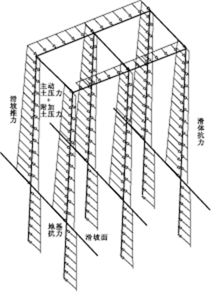
Contemporary force models of double row piles are mainly established on the basis of soil arch effect, ignoring interactions between top ring beam and link beam. In this paper, a force model of frame anti-sliding piles is presented to solve the problem efficiently for its spatial force analyzing techniques, which takes double row anti-slide piles as a single-layer multi-span frame structure composed of piles, beams and soils. A calculation approach for the model is proposed. It decomposes the frame structure into two parts along sliding surface, and deformation equations are rebuilt up correspondingly under pile lead border condition, continuous deformation of strong point, static force balance and deformation coordination between top ring beams and pile leads. A program is developed using MATLAB. Finally, the approach is applied in the test of Three Gorges reservoir geo-hazard prevention project, and the result shows that it is suitable for force calculation of frame anti-sliding piles.
Contemporary force models of double row piles are mainly established on the basis of soil arch effect, ignoring interactions between top ring beam and link beam. In this paper, a force model of frame anti-sliding piles is presented to solve the problem efficiently for its spatial force analyzing techniques, which takes double row anti-slide piles as a single-layer multi-span frame structure composed of piles, beams and soils. A calculation approach for the model is proposed. It decomposes the frame structure into two parts along sliding surface, and deformation equations are rebuilt up correspondingly under pile lead border condition, continuous deformation of strong point, static force balance and deformation coordination between top ring beams and pile leads. A program is developed using MATLAB. Finally, the approach is applied in the test of Three Gorges reservoir geo-hazard prevention project, and the result shows that it is suitable for force calculation of frame anti-sliding piles.


2011, 36(6): 1149-1154.
doi: 10.3799/dqkx.2011.121
Abstract:
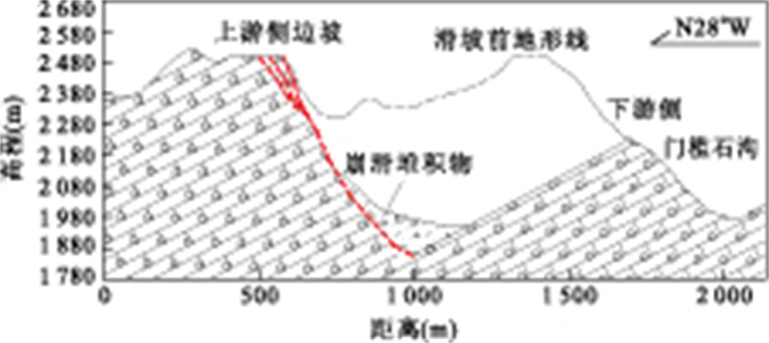
Wenchuan earthquake of magnitude of 8.0 triggered a large amount of rock slope collapse. In Yingxiu, many high magmatite rock slopes collapsed when Wenchuan earthquake struck, which resulted in huge damage. So it is urgent to study the collapse mechanism. This study takes Laohuzui collapse, a typical high slope collapse located at Yingxiu, the Wenchuan earthquake epicenter, as the object of this research. The engineering geological condition was investigated and the physical and mechanical parameters of rockmass and structural plane was determined. With the stereographic projection method using the discontinuity network simulation results, the basic failure modes of the slope was obtained, which is dual-plane sliding mainly due to the interconnected three group joints. Re-establishing the Laohuzui high slope model before earthquake, the process of dynamic response on the rock slope under earthquake was simulated by using 2DUDEC, and the destruction and collapse mechanism was analyzed. The main conclusion is that the Laohuzui slope collapse is a progressive failure. At first, the tensile failure took place in the slope toe, then the slope top would be subject to tensile failure followed by the front surface failure along the cut-through plane by three group joints, which resulted in the whole slope collapse. The slinging failure took place at the slope top under the seismic and gravity action condition.
Wenchuan earthquake of magnitude of 8.0 triggered a large amount of rock slope collapse. In Yingxiu, many high magmatite rock slopes collapsed when Wenchuan earthquake struck, which resulted in huge damage. So it is urgent to study the collapse mechanism. This study takes Laohuzui collapse, a typical high slope collapse located at Yingxiu, the Wenchuan earthquake epicenter, as the object of this research. The engineering geological condition was investigated and the physical and mechanical parameters of rockmass and structural plane was determined. With the stereographic projection method using the discontinuity network simulation results, the basic failure modes of the slope was obtained, which is dual-plane sliding mainly due to the interconnected three group joints. Re-establishing the Laohuzui high slope model before earthquake, the process of dynamic response on the rock slope under earthquake was simulated by using 2DUDEC, and the destruction and collapse mechanism was analyzed. The main conclusion is that the Laohuzui slope collapse is a progressive failure. At first, the tensile failure took place in the slope toe, then the slope top would be subject to tensile failure followed by the front surface failure along the cut-through plane by three group joints, which resulted in the whole slope collapse. The slinging failure took place at the slope top under the seismic and gravity action condition.


2011, 36(6): 1155-1164.
doi: 10.3799/dqkx.2011.122
Abstract:
Wenchuan earthquake triggered tens of thousands of landslides. Eight factors that influence landslide occurrence, including seismic intensity, lithology, slope angle, faults, elevation, slope aspect, drainages, and roads were created in raster data format base on geographical information system (GIS) and remote sensing (RS) technologies. The landslide hazard map was derived by using weight-of-evidence modeling. Earthquake-induced landslide susceptibility zonings of other eight impact factor combination categories were analyzed and mapped one after another, using GIS raster analysis methods. The eight different impact factor combinations analysis suggests that seismic intensity play an important role in determining the landslide susceptibility index value, while geological, geomorphological, and human-related factors only play minor roles. The resulting susceptibility map was divided into five categories, i.e. extremely high, high, moderate, low, and extremely low by using Natural Breaks law. The validation results show satisfactory agreement between the susceptibility map and the existing data on landslide distributions in the form of area under curve (AUC) up to 81.855%. The area with extremely high and high susceptibility accounts for about 11255.93km2, 23.12% of the study area, including landslide areas of 521.98km2, 73.36% of all landslide occurrence areas.
Wenchuan earthquake triggered tens of thousands of landslides. Eight factors that influence landslide occurrence, including seismic intensity, lithology, slope angle, faults, elevation, slope aspect, drainages, and roads were created in raster data format base on geographical information system (GIS) and remote sensing (RS) technologies. The landslide hazard map was derived by using weight-of-evidence modeling. Earthquake-induced landslide susceptibility zonings of other eight impact factor combination categories were analyzed and mapped one after another, using GIS raster analysis methods. The eight different impact factor combinations analysis suggests that seismic intensity play an important role in determining the landslide susceptibility index value, while geological, geomorphological, and human-related factors only play minor roles. The resulting susceptibility map was divided into five categories, i.e. extremely high, high, moderate, low, and extremely low by using Natural Breaks law. The validation results show satisfactory agreement between the susceptibility map and the existing data on landslide distributions in the form of area under curve (AUC) up to 81.855%. The area with extremely high and high susceptibility accounts for about 11255.93km2, 23.12% of the study area, including landslide areas of 521.98km2, 73.36% of all landslide occurrence areas.


2011, 36(6): 1165-1172.
doi: 10.3799/dqkx.2011.123
Abstract:
In this paper, we propose a two-region non-Darcian flow model near a pumping well in a leaky aquifer. The flow near the pumping well is assumed to be non-Darcian, with the area nearby defined as non-Darcian flow region, while the flow far away from the pumping well can be regarded as Darcian flow. The critical distance distinguishing the non-Darcian flow region and Darcian flow region can be determined by the critical Renolds number. We have used a linearization procedure coupled with Laplace transform to solve such a two-region non-Darcian flow model. The drawdowns both in the non-Darcian flow region and Darcian flow region have been obtained by using the so-called Stefest numerical Laplace inversion method. We have compared our results with those for the one-region Darcian flow model and the one-region non-Darcian flow model. The results indicate that: (1) The drawdowns in the non-Darcian flow region of different critical distances approach the same asymptotic value at early stages, as well as the result for the one-region non-Darcian flow model; while at late stages, significant difference has been found between the drawdowns obtained in this study; (2) A larger "non-Darcian hydraulic conductivity" kD results in a greater drawdown in the entire aquifer at early stages, while leads to a smaller drawdown in the non-Darcian flow region at late stages and has little impact on the drawdowns in the Darcian flow region; (3) The leakage effect on the drawdown is similar to that for the Darcian flow case, and it only exists at late stages; (4) When the wellbore storage is considered, all the drawdowns inside the well for different kD and dimensionless leakage parameter BD values approach the same asymptotic value at early stages and are straight lines in double logarithmic paper at early stages.
In this paper, we propose a two-region non-Darcian flow model near a pumping well in a leaky aquifer. The flow near the pumping well is assumed to be non-Darcian, with the area nearby defined as non-Darcian flow region, while the flow far away from the pumping well can be regarded as Darcian flow. The critical distance distinguishing the non-Darcian flow region and Darcian flow region can be determined by the critical Renolds number. We have used a linearization procedure coupled with Laplace transform to solve such a two-region non-Darcian flow model. The drawdowns both in the non-Darcian flow region and Darcian flow region have been obtained by using the so-called Stefest numerical Laplace inversion method. We have compared our results with those for the one-region Darcian flow model and the one-region non-Darcian flow model. The results indicate that: (1) The drawdowns in the non-Darcian flow region of different critical distances approach the same asymptotic value at early stages, as well as the result for the one-region non-Darcian flow model; while at late stages, significant difference has been found between the drawdowns obtained in this study; (2) A larger "non-Darcian hydraulic conductivity" kD results in a greater drawdown in the entire aquifer at early stages, while leads to a smaller drawdown in the non-Darcian flow region at late stages and has little impact on the drawdowns in the Darcian flow region; (3) The leakage effect on the drawdown is similar to that for the Darcian flow case, and it only exists at late stages; (4) When the wellbore storage is considered, all the drawdowns inside the well for different kD and dimensionless leakage parameter BD values approach the same asymptotic value at early stages and are straight lines in double logarithmic paper at early stages.