2012 Vol. 37, No. 1
Display Method:
2012, 37(1): 1-17.
doi: 10.3799/dqkx.2012.001
 PDF 4327KB
Abstract:
Exhumation processes of ultrahigh-pressure (UHP) metamorphic rocks, by which these deep-seated rocks were rapidly returned from mantle depths of more than 100 km within deep subduction zones into the upper crust and to the surface, are of paramount importance for the understanding of the kinematics and dynamics of convergent plate margins and continental collision belts. At least four large successive stages of the exhumation process of UHP metamorphic rocks in the Dabie-Sulu area, east-central China, mainly based on structural, petrological, geochemical data and available geochronological data, combined with previously regional polyphased deformation analyses, can be distinguished. Massive eclogites recorded the deep continental subduction/collision between the Sino-Korean and Yangtze cratons during the Triassic (~250-230 Ma).The early exhumation occurred after the peak of UHP metamorphism at conditions of up to > 3.1-4.0 GPa and 800±50 ℃, which may correspond to the D2 regional deformation phase and took place at mantle depths, displaying the model of vertical ductile extrusion, within the coesite stability field. The subsequent exhumation stages, corresponding with D3, D4 and D5 regional deformation phase, respectively, and two intermediate tectono-thermal events, i.e., the formation of the granulite/amphibolite facies symplectite or corona and the generation of extensive partial melting, occurred in crustal levels. Shear zones of an anastomosing rheological type were developed at diffterent stages and depths, indicating that the partitioning of deformation and metamorphism within the UHP metamorphic belt repeated. These imply that the exhumation of the UHP rocks is a complex tectonic process, in response to subduction/collision or extension of the continental crust, and is strongly constrained by a number of internal and external factors of the belt. In particular, fluids play important roles in the exhumation process of UHP rocks in the Dabie-Sulu area, east-central China.
Exhumation processes of ultrahigh-pressure (UHP) metamorphic rocks, by which these deep-seated rocks were rapidly returned from mantle depths of more than 100 km within deep subduction zones into the upper crust and to the surface, are of paramount importance for the understanding of the kinematics and dynamics of convergent plate margins and continental collision belts. At least four large successive stages of the exhumation process of UHP metamorphic rocks in the Dabie-Sulu area, east-central China, mainly based on structural, petrological, geochemical data and available geochronological data, combined with previously regional polyphased deformation analyses, can be distinguished. Massive eclogites recorded the deep continental subduction/collision between the Sino-Korean and Yangtze cratons during the Triassic (~250-230 Ma).The early exhumation occurred after the peak of UHP metamorphism at conditions of up to > 3.1-4.0 GPa and 800±50 ℃, which may correspond to the D2 regional deformation phase and took place at mantle depths, displaying the model of vertical ductile extrusion, within the coesite stability field. The subsequent exhumation stages, corresponding with D3, D4 and D5 regional deformation phase, respectively, and two intermediate tectono-thermal events, i.e., the formation of the granulite/amphibolite facies symplectite or corona and the generation of extensive partial melting, occurred in crustal levels. Shear zones of an anastomosing rheological type were developed at diffterent stages and depths, indicating that the partitioning of deformation and metamorphism within the UHP metamorphic belt repeated. These imply that the exhumation of the UHP rocks is a complex tectonic process, in response to subduction/collision or extension of the continental crust, and is strongly constrained by a number of internal and external factors of the belt. In particular, fluids play important roles in the exhumation process of UHP rocks in the Dabie-Sulu area, east-central China.


2012, 37(1): 18-24.
doi: 10.3799/dqkx.2012.002
Abstract:
Assemblages of the Upper Devonian ultrabasic rock, cumlative complex, diabase-dike swarm as well as basic pillow lava nipping radiolarian Si-sargillaceous rocks are discovered in Hujierte area, Inner Mongolia, China. They are typical ophiolite, which geochemical compositions accord with the characteristics of MORB. The age of 371.0±5.3 Ma using zircon U-Pb geologic dating method shows that there is the Upper Paleozoic era oceanic crust in this area, being a part of the Paleo-Asiatic Ocean, it is possibly a branch of ocean basin in archipelago paleogeographic pattern between the Siberian plate and the Sino-Korean plate, not inner the Sino-Korean plate, a northern part of the Sino-Korean plate should be on the south of Hujierte at the least.
Assemblages of the Upper Devonian ultrabasic rock, cumlative complex, diabase-dike swarm as well as basic pillow lava nipping radiolarian Si-sargillaceous rocks are discovered in Hujierte area, Inner Mongolia, China. They are typical ophiolite, which geochemical compositions accord with the characteristics of MORB. The age of 371.0±5.3 Ma using zircon U-Pb geologic dating method shows that there is the Upper Paleozoic era oceanic crust in this area, being a part of the Paleo-Asiatic Ocean, it is possibly a branch of ocean basin in archipelago paleogeographic pattern between the Siberian plate and the Sino-Korean plate, not inner the Sino-Korean plate, a northern part of the Sino-Korean plate should be on the south of Hujierte at the least.


2012, 37(1): 25-34.
doi: 10.3799/dqkx.2012.003
Abstract:
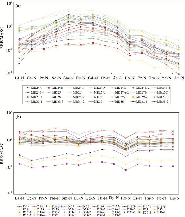
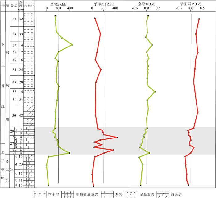
Trace elements and rare earth elements (REE) contents of conodonts, distinguished by very low color alteration index (CAI), were measured by laser ablation inductively coupled plasma mass spectrometry (LA-ICPMS) from Meishan D section across the Permian-Triassic boundary in Zhejiang Province. Comparative analyses of surrounding rocks geochemistry study, using solutions, a significantly different response to paleo-environmental changes was revealed. Present data indicate both the total REE contents in conodont and the Ce anomalies demonstrate a more sensitive change towards temporal environmental evolution than those in whole rocks. Therefore, conodont elements are more sensitive to ambient variation than the surrounding rocks, and it is reliable for LA-ICPMS in situ analysis of conodonts. Meanwhile, we can reconstruct the Early Triassic environment using the Ce anomaly of conodont, and it provides a new evidence for acute evolutions and long-term anoxia conditions from the Permo-Triassic crisis to the Early Triassic.
Trace elements and rare earth elements (REE) contents of conodonts, distinguished by very low color alteration index (CAI), were measured by laser ablation inductively coupled plasma mass spectrometry (LA-ICPMS) from Meishan D section across the Permian-Triassic boundary in Zhejiang Province. Comparative analyses of surrounding rocks geochemistry study, using solutions, a significantly different response to paleo-environmental changes was revealed. Present data indicate both the total REE contents in conodont and the Ce anomalies demonstrate a more sensitive change towards temporal environmental evolution than those in whole rocks. Therefore, conodont elements are more sensitive to ambient variation than the surrounding rocks, and it is reliable for LA-ICPMS in situ analysis of conodonts. Meanwhile, we can reconstruct the Early Triassic environment using the Ce anomaly of conodont, and it provides a new evidence for acute evolutions and long-term anoxia conditions from the Permo-Triassic crisis to the Early Triassic.


2012, 37(1): 35-46.
doi: 10.3799/dqkx.2012.004
Abstract:
Six fossil leaves with fine venation and well-preserved cuticles of Machilus tiantaiensis Ding S. T. et Sun B. N. sp. nov. (Lauraceae) were discovered from the Late Miocene Xiananshan Formation of Tiantai County, eastern Zhejiang Province, China. The fossils were characterized by elliptic shape with entire margin, acuminate apex, cuneate base and pinnate venation; the anticlinal walls of epidermal cells are undulated, the unicellular trichome bases are mostly found on the veins; leaves hypostomatic, stomata paracytic with two embedded guard cells and one or two subsidiary cells. The leaf cuticular and architectural features of these fossil leaves suggest the affinity within the genus Machilus. The quantitative traits of leaf morphology were studied here, and a free data analysis package (palaeontological statistics) is utilized for cluster analysis. The leaf morphologic and cuticular features show that the fossil is similar to the modern leaves of M. pingii mostly. The paleoatmospheric CO2 concentration is estimated through the stomatal ratio between the fossil species and the extant M. pingii Cheng ex Yang (nearest living relative of the fossil species), and the result shows that the level of atmospheric CO2 in the Late Miocene of Tiantai is about 407.9×10⁻⁶. The modern trees of Machilus are distributed in tropical and subtropical regions of South and Southeast Asia, which indicates that the Miocene climate of eastern China was warm and humid.
Six fossil leaves with fine venation and well-preserved cuticles of Machilus tiantaiensis Ding S. T. et Sun B. N. sp. nov. (Lauraceae) were discovered from the Late Miocene Xiananshan Formation of Tiantai County, eastern Zhejiang Province, China. The fossils were characterized by elliptic shape with entire margin, acuminate apex, cuneate base and pinnate venation; the anticlinal walls of epidermal cells are undulated, the unicellular trichome bases are mostly found on the veins; leaves hypostomatic, stomata paracytic with two embedded guard cells and one or two subsidiary cells. The leaf cuticular and architectural features of these fossil leaves suggest the affinity within the genus Machilus. The quantitative traits of leaf morphology were studied here, and a free data analysis package (palaeontological statistics) is utilized for cluster analysis. The leaf morphologic and cuticular features show that the fossil is similar to the modern leaves of M. pingii mostly. The paleoatmospheric CO2 concentration is estimated through the stomatal ratio between the fossil species and the extant M. pingii Cheng ex Yang (nearest living relative of the fossil species), and the result shows that the level of atmospheric CO2 in the Late Miocene of Tiantai is about 407.9×10⁻⁶. The modern trees of Machilus are distributed in tropical and subtropical regions of South and Southeast Asia, which indicates that the Miocene climate of eastern China was warm and humid.


2012, 37(1): 47-56.
doi: 10.3799/dqkx.2012.005
Abstract:
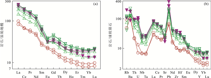
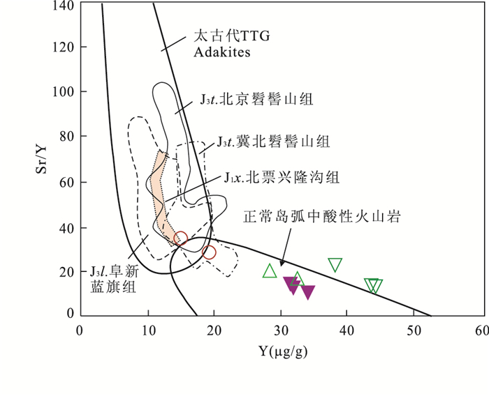
The Late Jurassic volcanic rocks of the Lanqi Formation in the Beipiao area, the western Liaoning Province, are composed of the lower andesitic breccia lava with tuffs and the upper trachyandesite. Based on the study of geochemistry, andesitic breccia lava are from 56.99% to 58.22% in SiO2, high Al2O3 (> 15%), high MgO (≤4.22%, 0.44 to 0.49 in Mg#)and low K2O (< 2.2%) characterizes by high Sr (> 500 μg/g), Cr (> 125 μg/g), Ni (> 47 μg/g) contents and higher Sr/Y ratio (> 28) and low REE (< 112 μg/g), U (< 0.3 μg/g), Th (< 2 μg/g) and HREE (Y < 20 μg/g, Yb < 1.6 μg/g) contents and by strongly fractionated LREE (10.49 to 10.59 in (La/Yb)N) and distinct positive Sr anomalies and negligible negative Eu anomalies (0.62 to 0.99 in Eu/Eu*), which are similar to those of the adakitic rock; and trachyandesite are from 52.09% to 61.08% in SiO2, high Al2O3(> 16.6%) and K2O (> 2%), low MgO (≤2.64%, 0.08 to 0.38 in Mg#) characterizes by high REE (> 180 μg/g), U (≥0.80 μg/g), Th (> 4 μg/g) and Sr (> 350 μg/g) contents, and low Cr (< 28 μg/g), Ni (< 19 μg/g) contents and low Sr/Y ratio (≤23) and by strongly fractionated LREE (10.22 to 16.28 in (La/Yb)N) and distinct negative Eu and Sr anomalies, which differ from those of the adakitic rock. All the volcanic rocks also show positive Pb and Ba anomalies, and negative Nb-Ta anomalies, and have moderate εSr(t) (20.15 to 23.34), TDM (1.45 to 1.50 Ga) and low εNd(t) (-7.69 to -8.62), which are similar to the features of the EMI-like component and of the ancient continental lower crust of the North China craton and the Late Jurassic-Early Cretaceous volcanic rocks in Yanshan orogen belt. In this paper, author thinks that andesitic magmas of Lanqi Formation are derived partial melting of foundered lower continental basaltic crust near the transition between the crust-mantle and occur the interaction of the mantle and crust, and trachyandesitic magmas from partial melting of foundered lower continental basaltic crust. The magma evolution of Lanqi Formation indicates that the process of the crust thinning from the thicken crust, it is an important significance to understand the deep process for the lithospheric thinning of the North China Craton during the Mesozoic era.
The Late Jurassic volcanic rocks of the Lanqi Formation in the Beipiao area, the western Liaoning Province, are composed of the lower andesitic breccia lava with tuffs and the upper trachyandesite. Based on the study of geochemistry, andesitic breccia lava are from 56.99% to 58.22% in SiO2, high Al2O3 (> 15%), high MgO (≤4.22%, 0.44 to 0.49 in Mg#)and low K2O (< 2.2%) characterizes by high Sr (> 500 μg/g), Cr (> 125 μg/g), Ni (> 47 μg/g) contents and higher Sr/Y ratio (> 28) and low REE (< 112 μg/g), U (< 0.3 μg/g), Th (< 2 μg/g) and HREE (Y < 20 μg/g, Yb < 1.6 μg/g) contents and by strongly fractionated LREE (10.49 to 10.59 in (La/Yb)N) and distinct positive Sr anomalies and negligible negative Eu anomalies (0.62 to 0.99 in Eu/Eu*), which are similar to those of the adakitic rock; and trachyandesite are from 52.09% to 61.08% in SiO2, high Al2O3(> 16.6%) and K2O (> 2%), low MgO (≤2.64%, 0.08 to 0.38 in Mg#) characterizes by high REE (> 180 μg/g), U (≥0.80 μg/g), Th (> 4 μg/g) and Sr (> 350 μg/g) contents, and low Cr (< 28 μg/g), Ni (< 19 μg/g) contents and low Sr/Y ratio (≤23) and by strongly fractionated LREE (10.22 to 16.28 in (La/Yb)N) and distinct negative Eu and Sr anomalies, which differ from those of the adakitic rock. All the volcanic rocks also show positive Pb and Ba anomalies, and negative Nb-Ta anomalies, and have moderate εSr(t) (20.15 to 23.34), TDM (1.45 to 1.50 Ga) and low εNd(t) (-7.69 to -8.62), which are similar to the features of the EMI-like component and of the ancient continental lower crust of the North China craton and the Late Jurassic-Early Cretaceous volcanic rocks in Yanshan orogen belt. In this paper, author thinks that andesitic magmas of Lanqi Formation are derived partial melting of foundered lower continental basaltic crust near the transition between the crust-mantle and occur the interaction of the mantle and crust, and trachyandesitic magmas from partial melting of foundered lower continental basaltic crust. The magma evolution of Lanqi Formation indicates that the process of the crust thinning from the thicken crust, it is an important significance to understand the deep process for the lithospheric thinning of the North China Craton during the Mesozoic era.


2012, 37(1): 57-68.
doi: 10.3799/dqkx.2012.006
Abstract:
In this paper, geochemical data of the major and trace elements are analyzed for the samples with different depths and lithology of the upper part of ocean drilling program (ODP) ODP 735B hole, Southwest Indian Ocean ridge. Based on these data, together with some other achievements, geochemical comparisions between and within these two cycles are discussed, and their petrogenesis are constrained. The major element characteristics indicate that their variation was well dominated by the mineral assemblage modal which are controlled by fractional crystallization of the rocks. The correlation of the bulk composition of major elements can, to some extent, indicate the formation of minerals and evolution of geochemical characteristics during the crystallization of basaltic melts. Besides the positive Eu anomaly, LREEs are clearly fractionated, while no fractionation of HREEs occurs. The spidergram shows depletion in Nb and Ta, and enrichment in Sr and K; however, this feature cannot be considered as the basis to decide the geochemical characteristics of the source so as to look into the geological significance.
In this paper, geochemical data of the major and trace elements are analyzed for the samples with different depths and lithology of the upper part of ocean drilling program (ODP) ODP 735B hole, Southwest Indian Ocean ridge. Based on these data, together with some other achievements, geochemical comparisions between and within these two cycles are discussed, and their petrogenesis are constrained. The major element characteristics indicate that their variation was well dominated by the mineral assemblage modal which are controlled by fractional crystallization of the rocks. The correlation of the bulk composition of major elements can, to some extent, indicate the formation of minerals and evolution of geochemical characteristics during the crystallization of basaltic melts. Besides the positive Eu anomaly, LREEs are clearly fractionated, while no fractionation of HREEs occurs. The spidergram shows depletion in Nb and Ta, and enrichment in Sr and K; however, this feature cannot be considered as the basis to decide the geochemical characteristics of the source so as to look into the geological significance.


2012, 37(1): 69-76.
doi: 10.3799/dqkx.2012.007
Abstract:
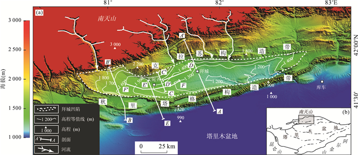
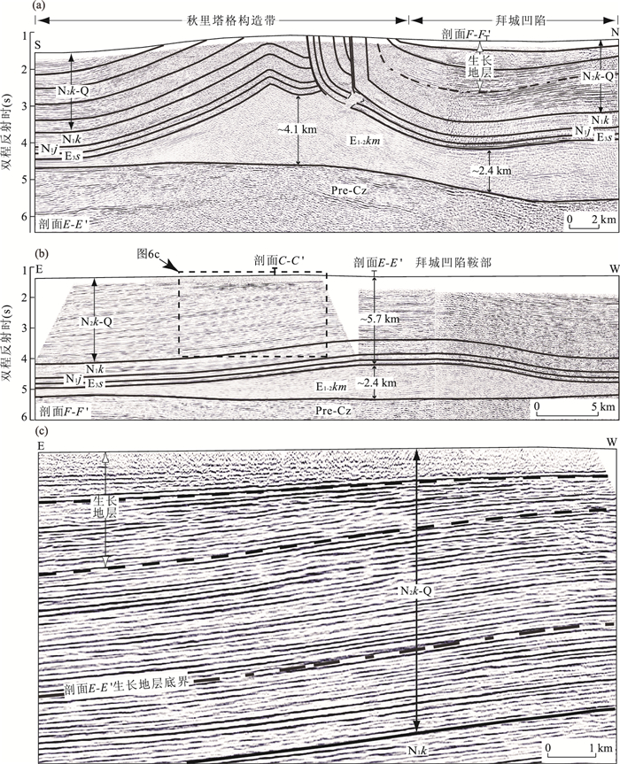
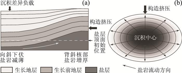
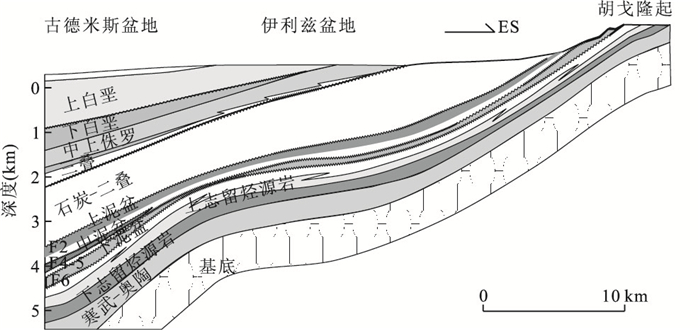
The role of differential sedimentary loading in deformation of viscous rock salt in contractional setting is unclear. Combined with field observation, well and seismic data, salt structures in Baicheng sag, Kuqa fold-and-thrust belt were constrained, and their formation mechanisms were investigated. The structural map of top salt shows that two depocenters were developed in Baicheng sag, eastern depocenter near Baicheng County and western depocenter to the south of well BZ1, respectively. Dawanqi salt pillow and saddle of Baicheng sag were developed between two depocenters. Seismic and well data reveals that: (1) the salt layer below two depocenters is very thin, while thick salt layer has accumulated between two depocenters; (2) Dawanqi salt pillow formed from the Late Pliocene to present; (3) the saddle of Baicheng sag, which is an antiform structure in E-W trend, formed from the end of Late Pliocene to present. Based on our investigations and previous studies, we propose a model showing salt flow related to salt structures in Baicheng sag, Kuqa fold-and-thrust belt, and it suggests that differential sedimentary loading plays an important role in Kuqa fold-and-thrust belt: (1) under bulk shortening and differential sedimentary loading, salt flew out of depocenter in three-dimensional; (2) salt flew dominantly along the direction of contraction (N-S) and also obviously along strike (E-W).
The role of differential sedimentary loading in deformation of viscous rock salt in contractional setting is unclear. Combined with field observation, well and seismic data, salt structures in Baicheng sag, Kuqa fold-and-thrust belt were constrained, and their formation mechanisms were investigated. The structural map of top salt shows that two depocenters were developed in Baicheng sag, eastern depocenter near Baicheng County and western depocenter to the south of well BZ1, respectively. Dawanqi salt pillow and saddle of Baicheng sag were developed between two depocenters. Seismic and well data reveals that: (1) the salt layer below two depocenters is very thin, while thick salt layer has accumulated between two depocenters; (2) Dawanqi salt pillow formed from the Late Pliocene to present; (3) the saddle of Baicheng sag, which is an antiform structure in E-W trend, formed from the end of Late Pliocene to present. Based on our investigations and previous studies, we propose a model showing salt flow related to salt structures in Baicheng sag, Kuqa fold-and-thrust belt, and it suggests that differential sedimentary loading plays an important role in Kuqa fold-and-thrust belt: (1) under bulk shortening and differential sedimentary loading, salt flew out of depocenter in three-dimensional; (2) salt flew dominantly along the direction of contraction (N-S) and also obviously along strike (E-W).


2012, 37(1): 77-92.
doi: 10.3799/dqkx.2012.008
Abstract:
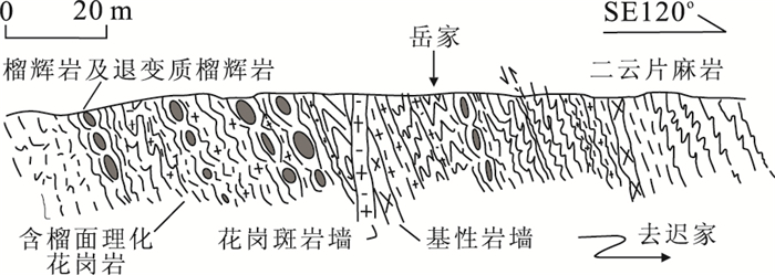
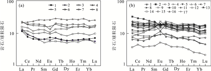
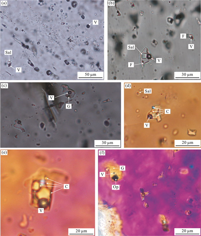
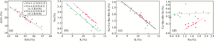
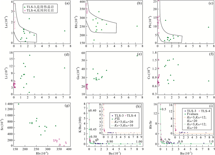
Tonglüshan Fe-Cu (Au) deposit is one of the largest skarn deposits in middle-lower Yangtze River metallogenic belt, which is associated with the Early Cretaceous Yangxin quartz diorite stock. Granitic pegmatites are well developed in the southeast mining area, emplaced in the Yangxin quartz diorite pluton and cut by garnet-diopside skarn. The cross-cutting relationships thus indicate that the granitic pegmatites are temporarily intermediate between the quartz diorite and skarn. Granitic pegmatites consist mainly of K-feldspar, plagioclase, and quartz, with conspicuous graphic textures marked by intergrowths of K-feldspar and quartz. K-feldspar with graphic textures from one granitic pegmatite dike has been successfully dated by the 40Ar/39Ar laser microprobe incremental heating technique, yielding a well-defined plateau age of 136.0±1.0 Ma (2σ), which is interpreted to be the emplacement age of the granitic pegmatite dike. The age constraints indicate that the pegmatites formed coevally with the quartz diorite stock in the mine and related skarn Cu-Au mineralization. In situ laser ablation inductively coupled plasma mass spectrometry (LA-ICPMS) provides a wealth of information on the major and trace elements of K-feldspar from granitic pegmatites and quartz diorite. The average bulk compositions of K-feldspar from the pegmatite and quartz diorite are represented by Or81Ab18 and Or78Ab21, respectively. K-feldspar minerals with graphic textures have higher Si and lower Al than those without graphic texture. Textural and geochemical data indicate that graphic textures in the pegmatites resulted from alternating growth of K-feldspar and quartz due to dynamic alteration of the relative concentration of SiO2 and Al2O3 in areas proximal to the outer zone of growing K-feldspar crystals. Both K-feldspars from quartz diorite and granitic pegmatite are enriched in large-ion lithophile elements (LILE), but the pegmatite contains more abundant Rb and Pb and lesser amounts of Ba, Sr, Li, and Cs. In the Rb-Ba, La-Ba, K/Ba-Ba, and Rb/Sr-Ba diagrams, samples of the pegmatite and quartz diorite display a trend predicted by the Rayleigh factional crystallization, indicating that the granitic pegmatite was generated by strong fractional crystallization of quartz dioritic magma. However, Pb, Li, and Ga deviate obviously from the trend of fractional crystallization, indicating these elements may have been complexed by a fluid phase. Abundance of melt and fluid inclusions in quartz minerals from the granitic pegmatites demonstrates that the pegmatite formed from melt and fluid coexisting system. This study provides a better understanding of the formation of pegmatites, exsolution of ore fluids from evolving magmas, and hydrothermal mineralization.
Tonglüshan Fe-Cu (Au) deposit is one of the largest skarn deposits in middle-lower Yangtze River metallogenic belt, which is associated with the Early Cretaceous Yangxin quartz diorite stock. Granitic pegmatites are well developed in the southeast mining area, emplaced in the Yangxin quartz diorite pluton and cut by garnet-diopside skarn. The cross-cutting relationships thus indicate that the granitic pegmatites are temporarily intermediate between the quartz diorite and skarn. Granitic pegmatites consist mainly of K-feldspar, plagioclase, and quartz, with conspicuous graphic textures marked by intergrowths of K-feldspar and quartz. K-feldspar with graphic textures from one granitic pegmatite dike has been successfully dated by the 40Ar/39Ar laser microprobe incremental heating technique, yielding a well-defined plateau age of 136.0±1.0 Ma (2σ), which is interpreted to be the emplacement age of the granitic pegmatite dike. The age constraints indicate that the pegmatites formed coevally with the quartz diorite stock in the mine and related skarn Cu-Au mineralization. In situ laser ablation inductively coupled plasma mass spectrometry (LA-ICPMS) provides a wealth of information on the major and trace elements of K-feldspar from granitic pegmatites and quartz diorite. The average bulk compositions of K-feldspar from the pegmatite and quartz diorite are represented by Or81Ab18 and Or78Ab21, respectively. K-feldspar minerals with graphic textures have higher Si and lower Al than those without graphic texture. Textural and geochemical data indicate that graphic textures in the pegmatites resulted from alternating growth of K-feldspar and quartz due to dynamic alteration of the relative concentration of SiO2 and Al2O3 in areas proximal to the outer zone of growing K-feldspar crystals. Both K-feldspars from quartz diorite and granitic pegmatite are enriched in large-ion lithophile elements (LILE), but the pegmatite contains more abundant Rb and Pb and lesser amounts of Ba, Sr, Li, and Cs. In the Rb-Ba, La-Ba, K/Ba-Ba, and Rb/Sr-Ba diagrams, samples of the pegmatite and quartz diorite display a trend predicted by the Rayleigh factional crystallization, indicating that the granitic pegmatite was generated by strong fractional crystallization of quartz dioritic magma. However, Pb, Li, and Ga deviate obviously from the trend of fractional crystallization, indicating these elements may have been complexed by a fluid phase. Abundance of melt and fluid inclusions in quartz minerals from the granitic pegmatites demonstrates that the pegmatite formed from melt and fluid coexisting system. This study provides a better understanding of the formation of pegmatites, exsolution of ore fluids from evolving magmas, and hydrothermal mineralization.


2012, 37(1): 93-104.
doi: 10.3799/dqkx.2012.009
Abstract:
Scientific classification of the geological objects is one of the most important basic research topics in geology. In this paper, thorough review of current research situation is made to establish the classification and nomenclature of deep sea sediments which unify the quantification and can be easily operated. Researches on various topics were conducted, eg., the composition and distribution of oceanic sediments, the relationship between water depth, average grain size and clay content, the discrepancy of clay, calcareous and siliceous content determination between smear and chemical analysis. The authors establish the quantitative relationship between calcareous and CaCO3, between siliceous and biogenic SiO2. This paper also compares and calibrates sedimentation method and laser method for grain size determination, and discusses generality and comparability of the classification and nomenclature system. Innovative key technique and scheme of classification and nomenclature for deep sea sediments were then put forward. The deep sea sediments are classified as deep sea clay, calcareous ooze, siliceous ooze, and clay-siliceous-calcareous ooze according to the simple classification method. The simple classification satisfies the general requirement of marine geological survey and basic understanding of sediment types. This method considers existing sediments mixture and existing classification methods. The deep sea sediments are further classified into 16 sub-types based on the sophisticated classification method, which therefore gives more detailed and comprehensive descriptions for the deep sea sediments and satisfies the requirement for comprehensive marine investigation. The classification and nomenclature for deep sea sediments are comparable with that for shallow sea sediments on diagram, indices, amount of types, naming methods, representation of mixture sediments and operability. Therefore, the classification and nomenclature for deep sea sediments is designed to be a succession of shallow sea sediments classification.
Scientific classification of the geological objects is one of the most important basic research topics in geology. In this paper, thorough review of current research situation is made to establish the classification and nomenclature of deep sea sediments which unify the quantification and can be easily operated. Researches on various topics were conducted, eg., the composition and distribution of oceanic sediments, the relationship between water depth, average grain size and clay content, the discrepancy of clay, calcareous and siliceous content determination between smear and chemical analysis. The authors establish the quantitative relationship between calcareous and CaCO3, between siliceous and biogenic SiO2. This paper also compares and calibrates sedimentation method and laser method for grain size determination, and discusses generality and comparability of the classification and nomenclature system. Innovative key technique and scheme of classification and nomenclature for deep sea sediments were then put forward. The deep sea sediments are classified as deep sea clay, calcareous ooze, siliceous ooze, and clay-siliceous-calcareous ooze according to the simple classification method. The simple classification satisfies the general requirement of marine geological survey and basic understanding of sediment types. This method considers existing sediments mixture and existing classification methods. The deep sea sediments are further classified into 16 sub-types based on the sophisticated classification method, which therefore gives more detailed and comprehensive descriptions for the deep sea sediments and satisfies the requirement for comprehensive marine investigation. The classification and nomenclature for deep sea sediments are comparable with that for shallow sea sediments on diagram, indices, amount of types, naming methods, representation of mixture sediments and operability. Therefore, the classification and nomenclature for deep sea sediments is designed to be a succession of shallow sea sediments classification.


2012, 37(1): 105-112.
doi: 10.3799/dqkx.2012.010
Abstract:
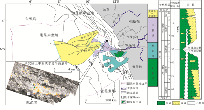
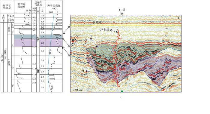
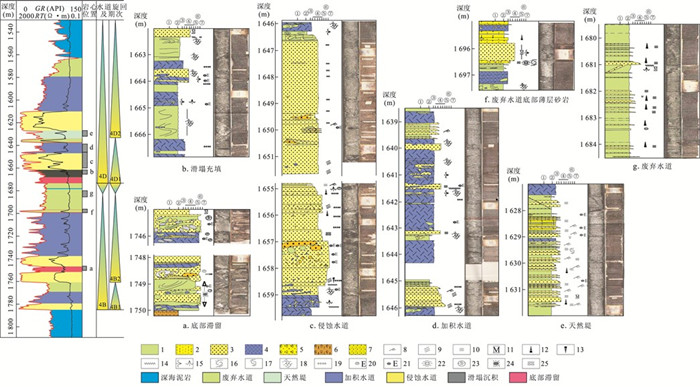
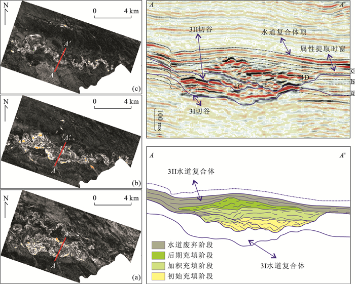
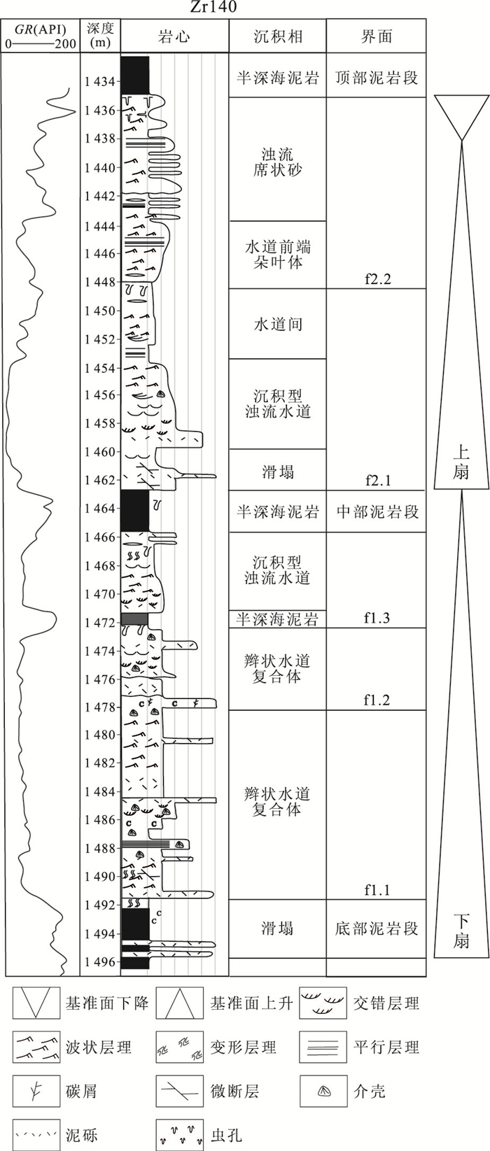
Deep-water channels are recognized as the very important hydrocarbon reservoir types in the oil industry. The research on the filling structure and evolution of deep water channel is very important for deep-water oil & gas exploration and development. In this paper, based on the well and 3D seismic data, the epoch, structure and evolution of Upper Miocene deep water channel in Congo Fan basin is analyzed. For the purposes of describing the internal architecture clearly, we divided the channels system into different grade channel complex and individual channel, which based on their sequence stratigraphic setting. Individual channel is mainly composed by 6 microfacies. From bottom to up, there are basal lags, slumps, eroded channels, stacked channels, levee, abandoned channels, which is the process of fluid energy gradually reducing; the 3th channel complex in the research area formed in a multi-stage process of erosion and filling. It can be divided into five evolution stages, including initial erosion stage, the initial filling stage, the stacking-filling stage, the later filling stage and the abandon stage. The different stages show the different filling architecture and distribution of 3th channel complex, which is controlled by the sea-level changes, the slope gradient and the rheological properties of gravity flow.
Deep-water channels are recognized as the very important hydrocarbon reservoir types in the oil industry. The research on the filling structure and evolution of deep water channel is very important for deep-water oil & gas exploration and development. In this paper, based on the well and 3D seismic data, the epoch, structure and evolution of Upper Miocene deep water channel in Congo Fan basin is analyzed. For the purposes of describing the internal architecture clearly, we divided the channels system into different grade channel complex and individual channel, which based on their sequence stratigraphic setting. Individual channel is mainly composed by 6 microfacies. From bottom to up, there are basal lags, slumps, eroded channels, stacked channels, levee, abandoned channels, which is the process of fluid energy gradually reducing; the 3th channel complex in the research area formed in a multi-stage process of erosion and filling. It can be divided into five evolution stages, including initial erosion stage, the initial filling stage, the stacking-filling stage, the later filling stage and the abandon stage. The different stages show the different filling architecture and distribution of 3th channel complex, which is controlled by the sea-level changes, the slope gradient and the rheological properties of gravity flow.
2012, 37(1): 113-124.
doi: 10.3799/dqkx.2012.011
Abstract:
The margin of South China in Late Triassic-Middle Jurassic had undergone multi transgression-regression cycles. The element geochemistry character indicates the paleosalinity and the water depth records the relative movements of the sea level. There are three levels of sea level change in the margin of South China. The grade III sea-level fluctuated frequently. There were 3 times in Late Triassic, 4 times in Early Jurassic and 2 times in Early or Middle Jurassic. These fluctuations constituted a large-scale transgression-regression cycle. The relative movements curve of the grade I sea-level is synchronous with the change of the long-period global sea-level curve in early Norian-late Sinemurian of the margin of South China. But it is contrary in late Sinemurian-Aalenian. The relative movements curve of the grade III sea-level and the short-period global sea-level curve occurred 4 fluctuations in Rhaetian-late Sinemurian. And they were almost simultaneously in time. The element migration and enrichment which were indicated by Sr/Cu reflected the warm-humid and dry-heat of the climate. The area of Middle Guangdong-East Guangdong in Late Triassic-Early-Middle Jurassic undergone the climate change of warm-humid to dry-heat and to warm-humid.
The margin of South China in Late Triassic-Middle Jurassic had undergone multi transgression-regression cycles. The element geochemistry character indicates the paleosalinity and the water depth records the relative movements of the sea level. There are three levels of sea level change in the margin of South China. The grade III sea-level fluctuated frequently. There were 3 times in Late Triassic, 4 times in Early Jurassic and 2 times in Early or Middle Jurassic. These fluctuations constituted a large-scale transgression-regression cycle. The relative movements curve of the grade I sea-level is synchronous with the change of the long-period global sea-level curve in early Norian-late Sinemurian of the margin of South China. But it is contrary in late Sinemurian-Aalenian. The relative movements curve of the grade III sea-level and the short-period global sea-level curve occurred 4 fluctuations in Rhaetian-late Sinemurian. And they were almost simultaneously in time. The element migration and enrichment which were indicated by Sr/Cu reflected the warm-humid and dry-heat of the climate. The area of Middle Guangdong-East Guangdong in Late Triassic-Early-Middle Jurassic undergone the climate change of warm-humid to dry-heat and to warm-humid.


2012, 37(1): 125-138.
doi: 10.3799/dqkx.2012.012
Abstract:
Upper Permian-Middle Triassic sections in Youjiang basin contain many volcanic tuff horizons. Zircon LA-ICP-MS U-Pb dating of 4 volcanic tuff samples from the bottom of the Luolou and Baifeng formations in the Jiuxu and Lizhou areas, Guangxi Province, yield the depositional ages of 252.8±1.8, 253.0±2.4, 247.2±1.5 and 239.3±2.7 Ma, respectively, which, together with the inherited or xenocrystal zircon ages (with peak values of 264 and 267 Ma), indicate that episodical volcanism occurred during Middle Permian Gudalupian and Middle Triassic Bithynian in southwestern China. The appearance of the inherited zircon ages (260~270 Ma) from the volcanic tuffs around the Permian-Triassic boundary (PTB) indicate the volcanic events in South China may have caused the End-Permian extinction. The depositional age of 247.2±1.5 Ma from the volcanic tuff at the bottom of the Middle Triassic Baifeng Formation indicates it is more appropriate to place the Early to Middle Trissic boundary at 247.2 Ma. The petrographical study of the volcanic tuffs indicates the Youjiang basin expierenced the tectonic transition from extension to compression after Middle Triassic, and especially after Bithynian, which resulted in the great tectonic subsidence of the basin.
Upper Permian-Middle Triassic sections in Youjiang basin contain many volcanic tuff horizons. Zircon LA-ICP-MS U-Pb dating of 4 volcanic tuff samples from the bottom of the Luolou and Baifeng formations in the Jiuxu and Lizhou areas, Guangxi Province, yield the depositional ages of 252.8±1.8, 253.0±2.4, 247.2±1.5 and 239.3±2.7 Ma, respectively, which, together with the inherited or xenocrystal zircon ages (with peak values of 264 and 267 Ma), indicate that episodical volcanism occurred during Middle Permian Gudalupian and Middle Triassic Bithynian in southwestern China. The appearance of the inherited zircon ages (260~270 Ma) from the volcanic tuffs around the Permian-Triassic boundary (PTB) indicate the volcanic events in South China may have caused the End-Permian extinction. The depositional age of 247.2±1.5 Ma from the volcanic tuff at the bottom of the Middle Triassic Baifeng Formation indicates it is more appropriate to place the Early to Middle Trissic boundary at 247.2 Ma. The petrographical study of the volcanic tuffs indicates the Youjiang basin expierenced the tectonic transition from extension to compression after Middle Triassic, and especially after Bithynian, which resulted in the great tectonic subsidence of the basin.


2012, 37(1): 139-144.
doi: 10.3799/dqkx.2012.013
Abstract:
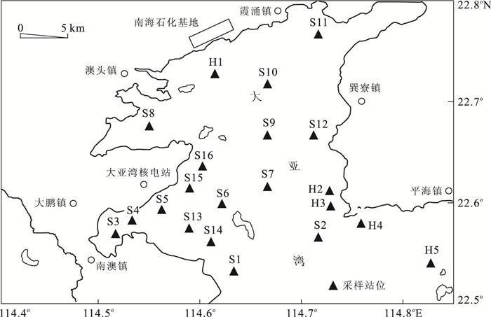
In order to make a comprehensive analysis of the heavy metals pollution and potential ecological risk in Daya bay, China, this paper focuses on seawater-sediment-Sargassum system as research object and analyzes the geochemical and biogeochemical characteristics for Cu, Pb and As in the seawater, surface sediment, Sargassum and cells of Sargassum. The results show that the concentrations of Cu, Pb and As are lower than the values of grade Ⅰ national standards for sediment, but some are of high-value in some sampling sites because of the source of input. The biological absorption coefficients indicate that the accumulation ability of heavy metals for Sargassum is arranged from high to low, as follows: As > Pb > Cu and Sargassum exhibits high abilities of accumulation of As. The study of the ultrastructure using transmission electron microscope reveals that the cell structures of Sargassum are anomalous and aberrant and there are lots of relatively high electron-density substances diffuse in the cells. The energy-dispersive spectroscopy (EDS) analysis shows that Cu, Pb and As in the form of comparatively high electron-density substance diffuse in the cell structures induce irreversible damage to the cell. The results provide the forepart warning information for ecological environment of Daya bay.
In order to make a comprehensive analysis of the heavy metals pollution and potential ecological risk in Daya bay, China, this paper focuses on seawater-sediment-Sargassum system as research object and analyzes the geochemical and biogeochemical characteristics for Cu, Pb and As in the seawater, surface sediment, Sargassum and cells of Sargassum. The results show that the concentrations of Cu, Pb and As are lower than the values of grade Ⅰ national standards for sediment, but some are of high-value in some sampling sites because of the source of input. The biological absorption coefficients indicate that the accumulation ability of heavy metals for Sargassum is arranged from high to low, as follows: As > Pb > Cu and Sargassum exhibits high abilities of accumulation of As. The study of the ultrastructure using transmission electron microscope reveals that the cell structures of Sargassum are anomalous and aberrant and there are lots of relatively high electron-density substances diffuse in the cells. The energy-dispersive spectroscopy (EDS) analysis shows that Cu, Pb and As in the form of comparatively high electron-density substance diffuse in the cell structures induce irreversible damage to the cell. The results provide the forepart warning information for ecological environment of Daya bay.

2012, 37(1): 145-155.
doi: 10.3799/dqkx.2012.014
Abstract:
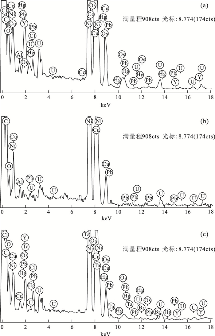
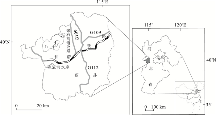
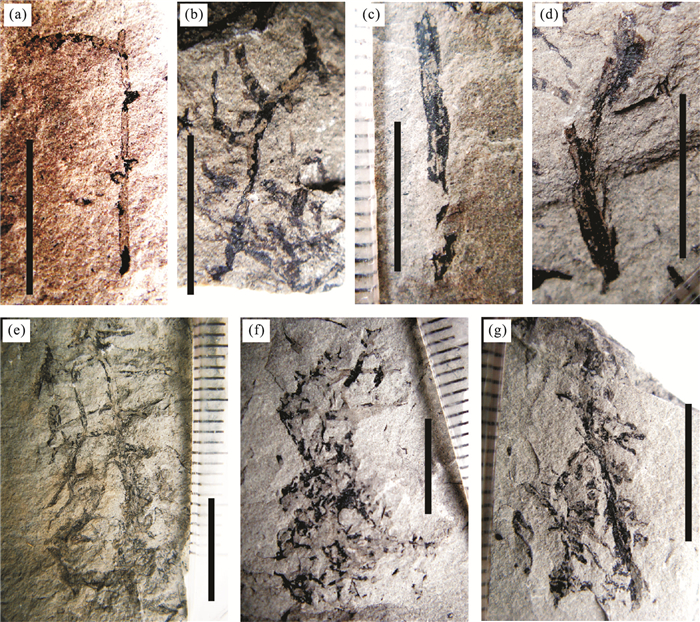
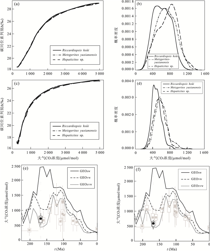
This paper summarizes the latest approaches and results of reconstructed paleo-CO2 level for the pre-Quaternary period. With the link and response between the carbon isotope composition of the fossil liverworts and the paleo-CO2 level, the carbon isotope discrimination (Δ13C) of fossil liverwort is introduced as a new proxy for paleo-CO2 level. It is an interdisciplinary research concerning the relevant domains such as geology, botany, phytophysiology, geochemistry, probability and statistics. The theory and process of the new proxy are clarified and its corresponding mathematical model, BRYOCARB, is introduced. Furthermore, in order to test the result of the new method, a case study has been carried out. Three species fossil liverworts of the Middle Jurassic were collected from Yuxian County, Hebei Province, which is one of the best known fossil sites of bryophytes in China. After a series of experiments and analyses, their carbon isotope compositions were measured and then their Δ13C were calculated. With the Δ13C values and some other environmental parameters running in BRYOCARB, the paleo-CO2 level was calculated, which is ~705 (BRYOCARBNP for with no pores liverworts) μmol/mol or ~566 (BRYOCARBP for with pores liverworts) μmol/mol. The results show a good agreement with other proxies and the long term geochemical models, which proves the carbon isotope discrimination of fossil liverwort is an effective proxy.
This paper summarizes the latest approaches and results of reconstructed paleo-CO2 level for the pre-Quaternary period. With the link and response between the carbon isotope composition of the fossil liverworts and the paleo-CO2 level, the carbon isotope discrimination (Δ13C) of fossil liverwort is introduced as a new proxy for paleo-CO2 level. It is an interdisciplinary research concerning the relevant domains such as geology, botany, phytophysiology, geochemistry, probability and statistics. The theory and process of the new proxy are clarified and its corresponding mathematical model, BRYOCARB, is introduced. Furthermore, in order to test the result of the new method, a case study has been carried out. Three species fossil liverworts of the Middle Jurassic were collected from Yuxian County, Hebei Province, which is one of the best known fossil sites of bryophytes in China. After a series of experiments and analyses, their carbon isotope compositions were measured and then their Δ13C were calculated. With the Δ13C values and some other environmental parameters running in BRYOCARB, the paleo-CO2 level was calculated, which is ~705 (BRYOCARBNP for with no pores liverworts) μmol/mol or ~566 (BRYOCARBP for with pores liverworts) μmol/mol. The results show a good agreement with other proxies and the long term geochemical models, which proves the carbon isotope discrimination of fossil liverwort is an effective proxy.

2012, 37(1): 156-162.
doi: 10.3799/dqkx.2012.015
Abstract:
Geological sequestration is an effective way to enhance the net reduction of global CO2 emission. In nature, there is vast amount of carbonation of mafic-ultramafic rocks, reacting with CO2 to produce stable carbonate minerals. Factors that affect carbonation reaction rates of mafic-ultramafic rocks with CO2 include temperature, pressure, pH values, fluid flow rate, and contact surface area, etc.. Exothermic mineral reactions can drive the carbonation system into a self-heating regime. Meanwhile, controlling fluid flow rates can maintain the optimal temperature for reaction rate. Peridotites in ophiolite, continental flood basalt and deep-sea basalt are widespread on the shallow surface of the earth, providing an alternative for CO2 storage. Current research demonstrates that both technology and economic cost are available. Therefore, mafic-ultramafic rocks have huge potential for CO2 sequestration and it is a new approach to CO2 geological sequestration.
Geological sequestration is an effective way to enhance the net reduction of global CO2 emission. In nature, there is vast amount of carbonation of mafic-ultramafic rocks, reacting with CO2 to produce stable carbonate minerals. Factors that affect carbonation reaction rates of mafic-ultramafic rocks with CO2 include temperature, pressure, pH values, fluid flow rate, and contact surface area, etc.. Exothermic mineral reactions can drive the carbonation system into a self-heating regime. Meanwhile, controlling fluid flow rates can maintain the optimal temperature for reaction rate. Peridotites in ophiolite, continental flood basalt and deep-sea basalt are widespread on the shallow surface of the earth, providing an alternative for CO2 storage. Current research demonstrates that both technology and economic cost are available. Therefore, mafic-ultramafic rocks have huge potential for CO2 sequestration and it is a new approach to CO2 geological sequestration.


2012, 37(1): 163-170.
doi: 10.3799/dqkx.2012.016
Abstract:
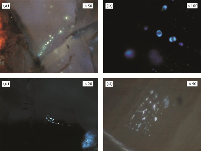
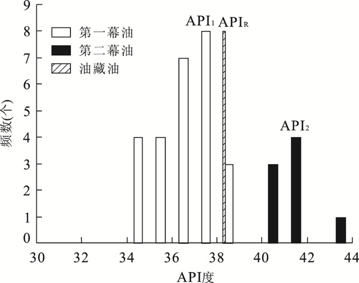
The petroleum accumulation always accompanies several petroleum charging episodes. The timing of petroleum accumulation determined by fluid inclusion method is usually representative of all the possible petroleum charging episodes, however, not all the petroleum charging episodes have contributions to present petroleum accumulation. Consequently, the premise for accurately determining the timing of petroleum accumulation is to confirm which petroleum charging episode has the most contribution to present petroleum accumulation. Petroleum inclusion is the direct evidence for petroleum migration and the variation of its fluorescent color reflects both of its maturity changing and the thermal evolvement level of its source rock if other influence factors have little effects on the oil maturity. The maturity of petroleum inclusion can be quantified by the relationship between the micro beam fluorescence spectrum parameters and API (American Petroleum Institute) degree of the known reservoir petroleum fluid. The analysis of contributions degree of petroleum charging to present petroleum accumulation is based on API degree prediction. The frequency distribution of API degree of petroleum inclusions should be a normal distribution in each petroleum charging episode. In theory, how many the episodes are, there are corresponding normal distributions of API degree of the petroleum inclusion. We can determine which episodic has the most contribution to the present petroleum accumulation by comparing the frequency distribution of API degree of petroleum inclusions with the API degree of present reservoir fluid, which can be a better restricted condition for the analysis of petroleum migration and accumulation and PVTx history of petroleum charging.
The petroleum accumulation always accompanies several petroleum charging episodes. The timing of petroleum accumulation determined by fluid inclusion method is usually representative of all the possible petroleum charging episodes, however, not all the petroleum charging episodes have contributions to present petroleum accumulation. Consequently, the premise for accurately determining the timing of petroleum accumulation is to confirm which petroleum charging episode has the most contribution to present petroleum accumulation. Petroleum inclusion is the direct evidence for petroleum migration and the variation of its fluorescent color reflects both of its maturity changing and the thermal evolvement level of its source rock if other influence factors have little effects on the oil maturity. The maturity of petroleum inclusion can be quantified by the relationship between the micro beam fluorescence spectrum parameters and API (American Petroleum Institute) degree of the known reservoir petroleum fluid. The analysis of contributions degree of petroleum charging to present petroleum accumulation is based on API degree prediction. The frequency distribution of API degree of petroleum inclusions should be a normal distribution in each petroleum charging episode. In theory, how many the episodes are, there are corresponding normal distributions of API degree of the petroleum inclusion. We can determine which episodic has the most contribution to the present petroleum accumulation by comparing the frequency distribution of API degree of petroleum inclusions with the API degree of present reservoir fluid, which can be a better restricted condition for the analysis of petroleum migration and accumulation and PVTx history of petroleum charging.


2012, 37(1): 171-180.
doi: 10.3799/dqkx.2012.017
Abstract:
The Permian Maokou Formation in southern China is taken as regional source rocks. Both the bottom and the top layers of Maokou Formation at the Shangsi section in Guangyuan, Northwest Sichuan developed siliceous rocks, however, only the top layer is taken as excellent source rocks with a thickness of 16 m and the maxium residual organic carbon of 10.90%. Based on the analysis of petrology, carbon isotopes and trace elements, it suggests the existence of upwelling in both the Wordian and Capitanian periods. Nutrient elements brought by upwelling are beneficial to form high primary productivity. The paleo-oceanic phytoplankton growth rate became from high to low and finally to high which coincided with the changes of atmospheric pCO2. The lower Maokou Formation with high primary productivity is poor source rock. The reason is that normoxic environment during the deposition and earlier diagenesis stages of the lower Maokou Formation went against the conservation of organic matter. While the upper Maokou Formation with high primary productivity is taken as excellent source rocks, as a great transgression event during Late Maokou period result in the occurrence of anaerobic environment which led to the formation of excellent source rock layer. The study on the controlling factors in the formation of excellent source rocks in the Maokou Formation is the base of distribution prediction of marine excellent source rocks and hydrocarbon reservoirs prediction in southern China.
The Permian Maokou Formation in southern China is taken as regional source rocks. Both the bottom and the top layers of Maokou Formation at the Shangsi section in Guangyuan, Northwest Sichuan developed siliceous rocks, however, only the top layer is taken as excellent source rocks with a thickness of 16 m and the maxium residual organic carbon of 10.90%. Based on the analysis of petrology, carbon isotopes and trace elements, it suggests the existence of upwelling in both the Wordian and Capitanian periods. Nutrient elements brought by upwelling are beneficial to form high primary productivity. The paleo-oceanic phytoplankton growth rate became from high to low and finally to high which coincided with the changes of atmospheric pCO2. The lower Maokou Formation with high primary productivity is poor source rock. The reason is that normoxic environment during the deposition and earlier diagenesis stages of the lower Maokou Formation went against the conservation of organic matter. While the upper Maokou Formation with high primary productivity is taken as excellent source rocks, as a great transgression event during Late Maokou period result in the occurrence of anaerobic environment which led to the formation of excellent source rock layer. The study on the controlling factors in the formation of excellent source rocks in the Maokou Formation is the base of distribution prediction of marine excellent source rocks and hydrocarbon reservoirs prediction in southern China.


2012, 37(1): 181-190.
doi: 10.3799/dqkx.2012.018
Abstract:
Based on cores and well logs, the analyses of tectono-sedimentary setting and facies show that F4 unit formed by submarine fan located in the continental rise. Lower Devonian F4 unit can be divided into upper cycle and lower cycle by a correlating fan-wide marine mud datum called "middle mud", which correspond individual the two-stage of the submarine fan evolution. Each cycle can be subdivided into several sub-cycles by mudstone or thin bedded siltstone, and mudstone which can be traced in the interior fan, thereby establishing the cronostraticframe of F4 unit. In light of the analysis of subfacies and their mechanisms, the reservoir types of F4 unit include braided channel-complex, sedimentary channel and tongue-like body. Facies distribution maps in the precision stratiraphic framework indicate that the submarine fan sediments formed F4 unit were supplied from at least two sources, i.e., northwest and southeast. The genetic type of F4 unit is a multiple point-source sand-rich fan. This study provides not only correlation strategy of submarine fan, but also a reliable geological model for the further development of F4 unit.
Based on cores and well logs, the analyses of tectono-sedimentary setting and facies show that F4 unit formed by submarine fan located in the continental rise. Lower Devonian F4 unit can be divided into upper cycle and lower cycle by a correlating fan-wide marine mud datum called "middle mud", which correspond individual the two-stage of the submarine fan evolution. Each cycle can be subdivided into several sub-cycles by mudstone or thin bedded siltstone, and mudstone which can be traced in the interior fan, thereby establishing the cronostraticframe of F4 unit. In light of the analysis of subfacies and their mechanisms, the reservoir types of F4 unit include braided channel-complex, sedimentary channel and tongue-like body. Facies distribution maps in the precision stratiraphic framework indicate that the submarine fan sediments formed F4 unit were supplied from at least two sources, i.e., northwest and southeast. The genetic type of F4 unit is a multiple point-source sand-rich fan. This study provides not only correlation strategy of submarine fan, but also a reliable geological model for the further development of F4 unit.


2012, 37(1): 191-198.
doi: 10.3799/dqkx.2012.019
Abstract:
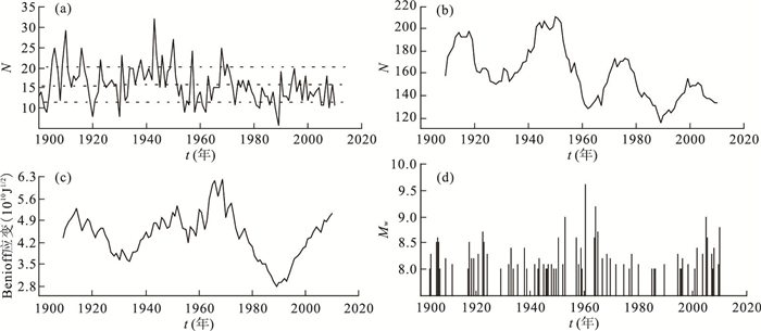
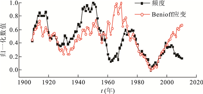
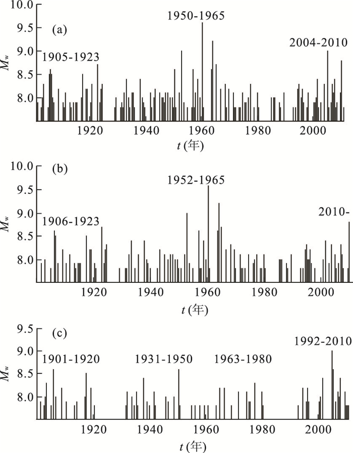
Using the global earthquake catalogue with Mw≥7.0 since 1900, we analyze the characteristics of great earthquakes in the global area, the circum-Pacific seismic belt (namely P-system)and the low-latitude circum-earth zone (namely E-systerm) respectively. In addition, the technique of Morlet wavelet transform is applied to quantitatively analyze the seismicity periodicities. Results show: (1) there are two principal periodic components, including 45.5 a and 32.0 a, in the global seismicity. For the P-system, the principal period is 45.5 a. The principal periodic components are 30.9 a and 47.5 a in the seismicity of the E-system; (2) The earthquake frequency with Mw≥7.0 of the globe, the P-system and the E-system show a prominent period of about 30 a. However, the temporal process of earthquake frequency is not synchronous with the global seismicity of Mw≥8.5, so it is not properly distinguish the active or quiet period by frequency and the variation of earthquake frequency may be a reaction that some global activity influence on the global seismicity; (3) The global great earthquakes showing the seismicity period is about 50.0 a (including an active and a quiet period). Great earthquakes (Mw≥8.5) in globe occurred frequently since 2004, showing a high actively trend based on the characteristics of great earthquakes cyclic process. It has been in high active period with many large earthquakes(Mw≥7.8) in the E-system since 1992, and currently it is in the end of the active period. The 2010 Chile Mw=8.8 event may be the sign that it begins a new active period in the P-system.
Using the global earthquake catalogue with Mw≥7.0 since 1900, we analyze the characteristics of great earthquakes in the global area, the circum-Pacific seismic belt (namely P-system)and the low-latitude circum-earth zone (namely E-systerm) respectively. In addition, the technique of Morlet wavelet transform is applied to quantitatively analyze the seismicity periodicities. Results show: (1) there are two principal periodic components, including 45.5 a and 32.0 a, in the global seismicity. For the P-system, the principal period is 45.5 a. The principal periodic components are 30.9 a and 47.5 a in the seismicity of the E-system; (2) The earthquake frequency with Mw≥7.0 of the globe, the P-system and the E-system show a prominent period of about 30 a. However, the temporal process of earthquake frequency is not synchronous with the global seismicity of Mw≥8.5, so it is not properly distinguish the active or quiet period by frequency and the variation of earthquake frequency may be a reaction that some global activity influence on the global seismicity; (3) The global great earthquakes showing the seismicity period is about 50.0 a (including an active and a quiet period). Great earthquakes (Mw≥8.5) in globe occurred frequently since 2004, showing a high actively trend based on the characteristics of great earthquakes cyclic process. It has been in high active period with many large earthquakes(Mw≥7.8) in the E-system since 1992, and currently it is in the end of the active period. The 2010 Chile Mw=8.8 event may be the sign that it begins a new active period in the P-system.


2012, 37(1): 199-206.
doi: 10.3799/dqkx.2012.020
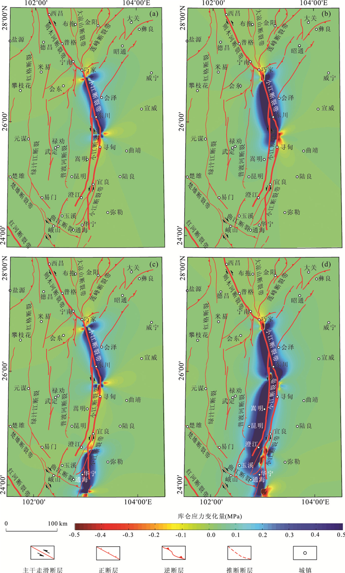
Abstract:
In this article, we calculate and map the patterns of Coulomb stress changes induced by a major earthquake sequence of 4 events M≥7 on the Xiaojiang-Zemuhe fault zone in 1733 to 1850, and analyze the effects of the static stress triggering induced by the individual preceding events to the following events. The results show that, in the sequence of major earthquakes, every following event occurred in an area where Coulomb stress had been remarkably increased by the preceding event (s). For instance, both the M=73/4 earthquake of 1733 on the northern segment of the Xiaojiang fault zone and the M=8 earthquake of 1833 on the middle segment of the fault zone induced positive increments of Coulomb stress on the Zemuhe fault zone, suggesting that the occurrence of the M=71/2 earthquake of 1850 on Zemuhe fault zone is related to the stress triggering effects caused by the 2 preceding major events. Again, the M=73/4 earthquake of 1733 on the northern segment of the Xiaojiang fault zone and the M=7 earthquake of 1789 on the middle-southern segment of the fault zone produced remarkable Coulomb stress triggering effects on the middle segment of the fault zone, that is related with the occurrence of the M=8 earthquake of 1833 on the middle segment of the fault zone. Therefore, we believe that mechanically significant interactions exist among the different segments of the Xiaojiang fault zone, as well as between the fault zone and the Zemuhe fault zone.
In this article, we calculate and map the patterns of Coulomb stress changes induced by a major earthquake sequence of 4 events M≥7 on the Xiaojiang-Zemuhe fault zone in 1733 to 1850, and analyze the effects of the static stress triggering induced by the individual preceding events to the following events. The results show that, in the sequence of major earthquakes, every following event occurred in an area where Coulomb stress had been remarkably increased by the preceding event (s). For instance, both the M=73/4 earthquake of 1733 on the northern segment of the Xiaojiang fault zone and the M=8 earthquake of 1833 on the middle segment of the fault zone induced positive increments of Coulomb stress on the Zemuhe fault zone, suggesting that the occurrence of the M=71/2 earthquake of 1850 on Zemuhe fault zone is related to the stress triggering effects caused by the 2 preceding major events. Again, the M=73/4 earthquake of 1733 on the northern segment of the Xiaojiang fault zone and the M=7 earthquake of 1789 on the middle-southern segment of the fault zone produced remarkable Coulomb stress triggering effects on the middle segment of the fault zone, that is related with the occurrence of the M=8 earthquake of 1833 on the middle segment of the fault zone. Therefore, we believe that mechanically significant interactions exist among the different segments of the Xiaojiang fault zone, as well as between the fault zone and the Zemuhe fault zone.