2012 Vol. 37, No. 4
Display Method:
 PDF 519KB
2012, 37(4): 627-634.
doi: 10.3799/dqkx.2012.072
Abstract:
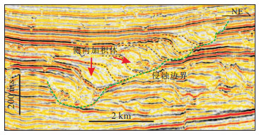
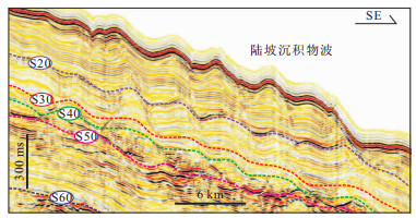
Deepwater reservoir has become one of the major issues in submarine hydrocarbon exploration in China recently. Based on high resolution 2D and 3D seismic data, depositional patterns and architectures of deepwater depositional systems are identified on the northwestern continental margins of the South China Sea. Apart from hemipelagic and pelagic mudstones, a number of gravity flow deposits are extensively developed, including large scale mass transport deposits (MTDs), submarine canyons and sediment waves. Four slope types are identified, including progradational type, slumping type, channelized type, wide and gentle type slopes. Each slope type has different morphological features and depositional architectures. Giant MTDs occur on the slumping and channelized slopes, whereas the sediment waves are only developed on the lower part of wide and gentle slope and the two sides of the Changchang segment of the Central Canyon. Due to special morphological features with an eastward flared shape and increasing water depth in the deepwater area since the Late Miocene, the unique Central Canyon with a trend paralleling to shelf break of northern margins is formed along the axial deepest water-depth line. The fillings in the Central Canyon are composed by not only turbidity channels from the head segment of the canyon in the west, but also the MTDs from the continental slope in the north, particularly from the slumping and channelized slopes. The Central Canyon system could be considered as multiple-sources to sink system for sediment transportation, and also a system containing important reservoirs in the deepwater area on the northwestern continental margin of the South China Sea.
Deepwater reservoir has become one of the major issues in submarine hydrocarbon exploration in China recently. Based on high resolution 2D and 3D seismic data, depositional patterns and architectures of deepwater depositional systems are identified on the northwestern continental margins of the South China Sea. Apart from hemipelagic and pelagic mudstones, a number of gravity flow deposits are extensively developed, including large scale mass transport deposits (MTDs), submarine canyons and sediment waves. Four slope types are identified, including progradational type, slumping type, channelized type, wide and gentle type slopes. Each slope type has different morphological features and depositional architectures. Giant MTDs occur on the slumping and channelized slopes, whereas the sediment waves are only developed on the lower part of wide and gentle slope and the two sides of the Changchang segment of the Central Canyon. Due to special morphological features with an eastward flared shape and increasing water depth in the deepwater area since the Late Miocene, the unique Central Canyon with a trend paralleling to shelf break of northern margins is formed along the axial deepest water-depth line. The fillings in the Central Canyon are composed by not only turbidity channels from the head segment of the canyon in the west, but also the MTDs from the continental slope in the north, particularly from the slumping and channelized slopes. The Central Canyon system could be considered as multiple-sources to sink system for sediment transportation, and also a system containing important reservoirs in the deepwater area on the northwestern continental margin of the South China Sea.


2012, 37(4): 635-644.
doi: 10.3799/dqkx.2012.073
Abstract:
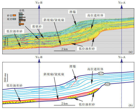
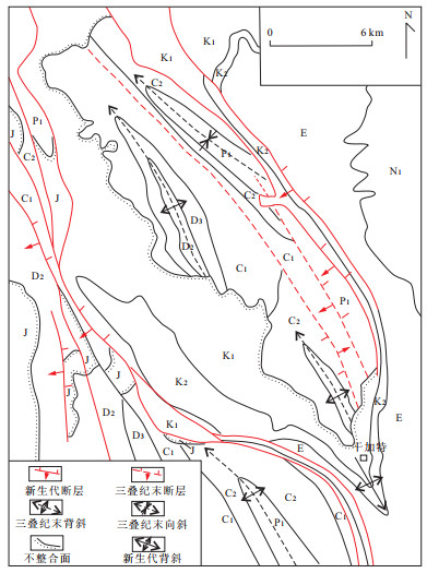
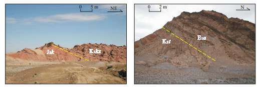
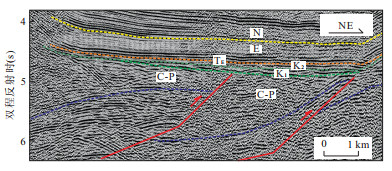
Jurassic-Cretaceous strata are widespread in outcrops of northern margin of West Kunlun Mountains. However, drilling data indicate that they are sparsely and discontinuously distributed in the foreland overlaid regions. To determine the contact relations between the Jurassic-Cretaceous and overlaying and underlying strata, and their distribution and thickness variation, new data of field geologic investigation and interpretation of seismic profiles are presented, which suggest that the Jurassic-Cretaceous strata overlay the beneath sequences in an angular unconformity and contact with the overlaying sediments in a parallel unconformity, while within the Jurassic-Cretaceous sequence they contact with each other in conformity or parallel unconformity. These contact relations show totally different features compared to those of adjacent regions. Based on these contact relations, we establish structural interpretation models. The structural interpretation of seismic profiles and subsequent strata distribution and thickness variation indicate that compression event in End Triassic and its remnant paleo-tectonotopography has controlled occurrence and thickness of Jurassic-Cretaceous strata, while compression since Neogene has reconstructed their distribution and thickness patterns. The study results provide significant constraints for the Mesozoic-Cenozoic evolution of piedmont fold and thrust belt in the front of West Kunlun Mountains and petroleum exploration in this region.
Jurassic-Cretaceous strata are widespread in outcrops of northern margin of West Kunlun Mountains. However, drilling data indicate that they are sparsely and discontinuously distributed in the foreland overlaid regions. To determine the contact relations between the Jurassic-Cretaceous and overlaying and underlying strata, and their distribution and thickness variation, new data of field geologic investigation and interpretation of seismic profiles are presented, which suggest that the Jurassic-Cretaceous strata overlay the beneath sequences in an angular unconformity and contact with the overlaying sediments in a parallel unconformity, while within the Jurassic-Cretaceous sequence they contact with each other in conformity or parallel unconformity. These contact relations show totally different features compared to those of adjacent regions. Based on these contact relations, we establish structural interpretation models. The structural interpretation of seismic profiles and subsequent strata distribution and thickness variation indicate that compression event in End Triassic and its remnant paleo-tectonotopography has controlled occurrence and thickness of Jurassic-Cretaceous strata, while compression since Neogene has reconstructed their distribution and thickness patterns. The study results provide significant constraints for the Mesozoic-Cenozoic evolution of piedmont fold and thrust belt in the front of West Kunlun Mountains and petroleum exploration in this region.


2012, 37(4): 645-653.
doi: 10.3799/dqkx.2012.074
Abstract:
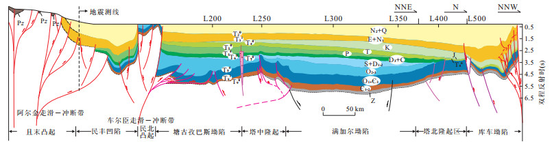
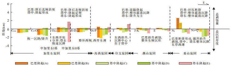
Based on elaborate geological structural interpretation of seismic profiles, this paper analyzes in details the controlling of fault activity to development of central uplift zone and marine cratonic evolution of Tarim basin. The research indicates that there are mainly three episodes of fault systems: the middle Caledonian orogeny I episode, the middle Caledonian orogeny II episode and the mid-late Himalayan (since Late Miocene). These fault systems controlled the tectonic evolution of central uplift zone and migration of uplift-sag, in which Bachu uplift experienced back-bulge ramp in the mid-late of Caledonian period, forebulge in the Hercynian-Yanshanian period and the latest compressional fault uplift in the mid-late of Himalayan period, Tazhong uplift started at the first episode of Caledonian period and formed at the second episode of Caledonian period and Tadong uplift started and formed at the second episode of Caledonian period. The evolution of marine cratonic basin is divided into three periods which are formation, disintegration and extinction. Analysis shows that the fault system of Caledonian I and Caledonian II episodes resulted in breakup of Tarim marine cratonic basin.
Based on elaborate geological structural interpretation of seismic profiles, this paper analyzes in details the controlling of fault activity to development of central uplift zone and marine cratonic evolution of Tarim basin. The research indicates that there are mainly three episodes of fault systems: the middle Caledonian orogeny I episode, the middle Caledonian orogeny II episode and the mid-late Himalayan (since Late Miocene). These fault systems controlled the tectonic evolution of central uplift zone and migration of uplift-sag, in which Bachu uplift experienced back-bulge ramp in the mid-late of Caledonian period, forebulge in the Hercynian-Yanshanian period and the latest compressional fault uplift in the mid-late of Himalayan period, Tazhong uplift started at the first episode of Caledonian period and formed at the second episode of Caledonian period and Tadong uplift started and formed at the second episode of Caledonian period. The evolution of marine cratonic basin is divided into three periods which are formation, disintegration and extinction. Analysis shows that the fault system of Caledonian I and Caledonian II episodes resulted in breakup of Tarim marine cratonic basin.


2012, 37(4): 654-666.
doi: 10.3799/dqkx.2012.075
Abstract:
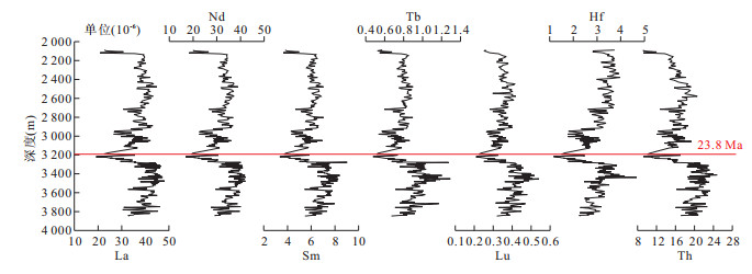
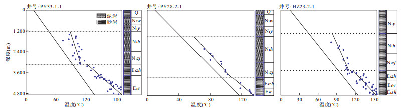
An important tectonic event and associated unconformity surface occurred in deepwater area of the Pearl River Mouth basin, South China Sea. Research results indicate: (1)The 23.8 Ma tectonic events is the convert face of Cenozoic tectonic evolution in Zhu Ⅱ depression of the basin, which divides the Paleogene syn-rifting stage and Neogene post-rifting stage. In the former, the basin-forming mechanisms are dominated by the stretching and strike-slip faults systems, however, in the later, faulting and geothermal effect (late in geothermal effect primarily) control the basin evolution. (2) The 23.8 Ma tectonic events resulted in great change in basin sedimentary filling. Through the analysis of trace elements and isotope, the sediment provenance comes from the southeast coastal granite materials before the 23.8 Ma, but from the east of the Qinghai-Tibet plateau and the Yunnan-Guizhou plateau after 23.8 Ma. At the same time, the slope-break surface jumps from south to north in the Baiyun depression, and sedimentary facies change also from shallow continental shelf to deepwater slop environments. (3) The 23.8 Ma tectonic events is a transferring surface of basin geothermal system. The quantitative restore of typical drilling thermal history shows geothermal gradient obviously changes at the 23.8 Ma. Through the thermal history inversion in deepwater area of the Pearl River Mouth basin, geothermal gradient rising process occur during the Paleogene, indicating the basin underwent extensional process, and the geothermal gradient falls clearly after 23.8 Ma, indicating the basin underwent a geothermal subsidence process. (4) The 23.8 Ma tectonic events reveals a great change in volcanic activity, the single ingredient of large basaltic magma eruption gradually strengthened before the 23.8 Ma, and the eruption gradually weakened after the surface. A dynamic model of the 23.8 Ma tectonic events is established. The mantle diapir from the asthenosphere flowing is regarded as the power source for the South China Sea spreading. The 23.8 Ma tectonic events resulted from the jumping of the South China Sea spreading and change in mantle diapir possibly related with the deep magma escaping.
An important tectonic event and associated unconformity surface occurred in deepwater area of the Pearl River Mouth basin, South China Sea. Research results indicate: (1)The 23.8 Ma tectonic events is the convert face of Cenozoic tectonic evolution in Zhu Ⅱ depression of the basin, which divides the Paleogene syn-rifting stage and Neogene post-rifting stage. In the former, the basin-forming mechanisms are dominated by the stretching and strike-slip faults systems, however, in the later, faulting and geothermal effect (late in geothermal effect primarily) control the basin evolution. (2) The 23.8 Ma tectonic events resulted in great change in basin sedimentary filling. Through the analysis of trace elements and isotope, the sediment provenance comes from the southeast coastal granite materials before the 23.8 Ma, but from the east of the Qinghai-Tibet plateau and the Yunnan-Guizhou plateau after 23.8 Ma. At the same time, the slope-break surface jumps from south to north in the Baiyun depression, and sedimentary facies change also from shallow continental shelf to deepwater slop environments. (3) The 23.8 Ma tectonic events is a transferring surface of basin geothermal system. The quantitative restore of typical drilling thermal history shows geothermal gradient obviously changes at the 23.8 Ma. Through the thermal history inversion in deepwater area of the Pearl River Mouth basin, geothermal gradient rising process occur during the Paleogene, indicating the basin underwent extensional process, and the geothermal gradient falls clearly after 23.8 Ma, indicating the basin underwent a geothermal subsidence process. (4) The 23.8 Ma tectonic events reveals a great change in volcanic activity, the single ingredient of large basaltic magma eruption gradually strengthened before the 23.8 Ma, and the eruption gradually weakened after the surface. A dynamic model of the 23.8 Ma tectonic events is established. The mantle diapir from the asthenosphere flowing is regarded as the power source for the South China Sea spreading. The 23.8 Ma tectonic events resulted from the jumping of the South China Sea spreading and change in mantle diapir possibly related with the deep magma escaping.


2012, 37(4): 667-678.
doi: 10.3799/dqkx.2012.076
Abstract:
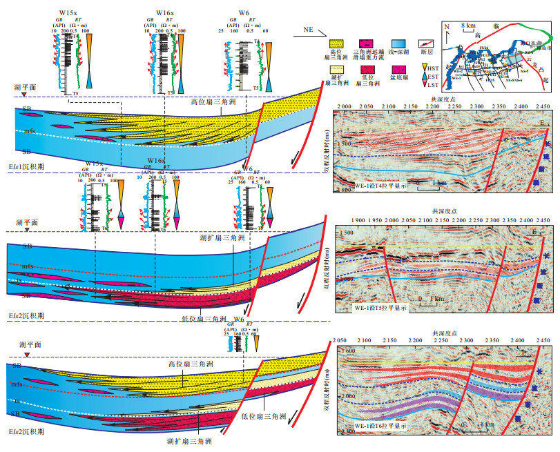
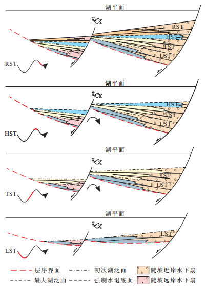
To explore the sequence stratigraphic architecture of Paleogene Liushagang Formation (Els) in the Fushan sag of Beibuwan basin, by using drilling, logging, seismic data, the isochronous sequence stratigraphic framework in systems tracts level has been established. Aiming at different tectonic units in Els of Fushan sag, with comprehensive consideration of tectonic activities, basin marginal background, provenance supply, etc., sequence strata architecture of Els can be extracted into four types, namely, fault controlling steep type, multi-stage fault terrace type, flexure break type, and gentle slope break type. The features of sequence architecture, different types of traps developed in different sequence architecture. It is of great significance to the hydrocarbon exploration in Els, Fushan sag.
To explore the sequence stratigraphic architecture of Paleogene Liushagang Formation (Els) in the Fushan sag of Beibuwan basin, by using drilling, logging, seismic data, the isochronous sequence stratigraphic framework in systems tracts level has been established. Aiming at different tectonic units in Els of Fushan sag, with comprehensive consideration of tectonic activities, basin marginal background, provenance supply, etc., sequence strata architecture of Els can be extracted into four types, namely, fault controlling steep type, multi-stage fault terrace type, flexure break type, and gentle slope break type. The features of sequence architecture, different types of traps developed in different sequence architecture. It is of great significance to the hydrocarbon exploration in Els, Fushan sag.


2012, 37(4): 679-692.
doi: 10.3799/dqkx.2012.077
Abstract:
The lithofacies of the upper Middle Triassic Guanggaishan Formation outcropping along both northern and southern sides of the Bailongjiang uplift (composite anticline), southwestern Qinling orogenic belt were studied in this article. By sedimentation and lithofacies, the Guanggaishan Formation is identified and classified into five types: debris flow, grain flow, turbidity current, traction current, and still-water bedding current, which can be subdivided into more sublithofacies in this paper. Nine cycles of lithofacies sequence have been recognized from the Feixian section, Diebu in northern side of the Bailongjiang uplift, of which a single cycle is composed of gavel debris facies to Bouma sequence, indicating cyclicity and periodicity of tectonism and sedimentation. It is proposed that there are some similarities and discrepancies for lithofacies in two sides of the Bailongjiang uplift. The similarities are well-developed slope debris and turbidity flow facies with little slumping and collapsed facies, and proximal sources comprising limestone. The discrepancies are different texture and cycle number of facies sequence from different sections, different aged strata in source regions. The assemblage of lithofacies indicates that the Guanggaishan Formation is of relatively ramp continental slope facies within remnant sea basin, where the basin had been formed by flexing during continent collision. According to deep sea basins and remnant basin in the Late Paleozoic-Early Middle Triassic for the Taohe basin, north to the Bailongjiang uplift, and to the sharing of the same basin basement for the Ruo'ergai flysch basin, south to the uplift, it is inferred that there could be no shallow platform carbonate facies under the both flysch basins, which means poor prospective for oil-gas resources exploration in the region.
The lithofacies of the upper Middle Triassic Guanggaishan Formation outcropping along both northern and southern sides of the Bailongjiang uplift (composite anticline), southwestern Qinling orogenic belt were studied in this article. By sedimentation and lithofacies, the Guanggaishan Formation is identified and classified into five types: debris flow, grain flow, turbidity current, traction current, and still-water bedding current, which can be subdivided into more sublithofacies in this paper. Nine cycles of lithofacies sequence have been recognized from the Feixian section, Diebu in northern side of the Bailongjiang uplift, of which a single cycle is composed of gavel debris facies to Bouma sequence, indicating cyclicity and periodicity of tectonism and sedimentation. It is proposed that there are some similarities and discrepancies for lithofacies in two sides of the Bailongjiang uplift. The similarities are well-developed slope debris and turbidity flow facies with little slumping and collapsed facies, and proximal sources comprising limestone. The discrepancies are different texture and cycle number of facies sequence from different sections, different aged strata in source regions. The assemblage of lithofacies indicates that the Guanggaishan Formation is of relatively ramp continental slope facies within remnant sea basin, where the basin had been formed by flexing during continent collision. According to deep sea basins and remnant basin in the Late Paleozoic-Early Middle Triassic for the Taohe basin, north to the Bailongjiang uplift, and to the sharing of the same basin basement for the Ruo'ergai flysch basin, south to the uplift, it is inferred that there could be no shallow platform carbonate facies under the both flysch basins, which means poor prospective for oil-gas resources exploration in the region.


2012, 37(4): 693-706.
doi: 10.3799/dqkx.2012.078
Abstract:
The Zhangxia Formation in the Longmen area, Luoyang City, was a set of deposited thin-bedded microcrystalline limestone and thick-bedded oolitic limestone, with abundant bioturbation. Based on sedimentology and ichnology characteristics, six ichnofabrics were determined, namely from the bottom up, Planolites montanus ichnofabric in low energy, subtidal carbonate platform; Palaeophycus tubularis-Thalassinoides horizontalis ichnofabric in shallow, medium energy, subtidal carbonate platform; Skolithos linearis-Planolites montanus ichnofabric in onshore oolitic shoals, inter flat and fore shoals of oolitic platform with alternation of high and low energy; blurry bioturbation ichnofabric in deeper water, lower energy of open platform; Macaronichnus segregatis ichnofabric in oolitic shoals with high energy and Palaeophycus heberti ichnofabric in subtidal restricted platform with low energy. Zhangxia Formation in Longmen area developed from carbonate platform without oolitic shoals to with oolitic shoals. The sedimentary environment evolved from onshore oolitic shoals to open platform without oolitic shoals, and finally ended up with platform oolitic shoals and restricted platform with the regression.
The Zhangxia Formation in the Longmen area, Luoyang City, was a set of deposited thin-bedded microcrystalline limestone and thick-bedded oolitic limestone, with abundant bioturbation. Based on sedimentology and ichnology characteristics, six ichnofabrics were determined, namely from the bottom up, Planolites montanus ichnofabric in low energy, subtidal carbonate platform; Palaeophycus tubularis-Thalassinoides horizontalis ichnofabric in shallow, medium energy, subtidal carbonate platform; Skolithos linearis-Planolites montanus ichnofabric in onshore oolitic shoals, inter flat and fore shoals of oolitic platform with alternation of high and low energy; blurry bioturbation ichnofabric in deeper water, lower energy of open platform; Macaronichnus segregatis ichnofabric in oolitic shoals with high energy and Palaeophycus heberti ichnofabric in subtidal restricted platform with low energy. Zhangxia Formation in Longmen area developed from carbonate platform without oolitic shoals to with oolitic shoals. The sedimentary environment evolved from onshore oolitic shoals to open platform without oolitic shoals, and finally ended up with platform oolitic shoals and restricted platform with the regression.


2012, 37(4): 707-718.
doi: 10.3799/dqkx.2012.079
Abstract:
The process of oil and gas accumulation is highly complex in Lunnan low uplift due to the fact that hydrocarbon has been generated by multiple petroleum kitchens.Based on the principles of dynamics of petroleum accumulation, we found the macro frame of the hydrocarbon conduits system and conducting pattern of Lunnan petroleum province in this paper.The distribution with basin-scale of the Silurian argulite proves that the Ordovician karst reservoir hasn't been formed, when the Cambrian source rock got into the step of hydrocarbon generating climax in the late Caledonian movement.Therefore, Silurian sand bed was the main lateral conduit path of the oil-gas originated from the Cambrian.Meanwhile, the intense uplift with a long time exposure happened in the early Hercynian movement triggered a deep hypergene karst that upgraded the quality of the carbonate reservoir effectively, and the horizontal migration pathway of the petroleum was the Ordovician karst bed.The essence of the hydrocarbon accumulating in Himalayan movement is a process of adjustment and reconstruction to the Ordovician self-contained pools formed in the Hercynian movement, which included gas washing triggered by the excessive dry gas invasion and the vertical conducting adjustment by faults of various scale.The origin of the Triassic pools in Lunnan, Sangtamu and Jiefangqudong oilfield was mainly controlled by the vertical conduit of discordogenic fault.Furthermore, the powerful seal ability of the overlying cap rock restrained the lateral conducting bed of the dry gas distributed in the Ordovician so that the oil pool in the Ordovician transformed into the secondary condensate pool by fractionation of gas washing. Moreover, the phase fractionation of decompression caused by fractures, intrabed faults that connected Ordovician and Carboniferous in the Sangtamu area and the endostratic fault of Ordovician not only formed the secondary condensates with vapour phase in the Carboniferous traps, but also controlled the distribution of the condensate pool and its fluid property in Lungudong oilfield.
The process of oil and gas accumulation is highly complex in Lunnan low uplift due to the fact that hydrocarbon has been generated by multiple petroleum kitchens.Based on the principles of dynamics of petroleum accumulation, we found the macro frame of the hydrocarbon conduits system and conducting pattern of Lunnan petroleum province in this paper.The distribution with basin-scale of the Silurian argulite proves that the Ordovician karst reservoir hasn't been formed, when the Cambrian source rock got into the step of hydrocarbon generating climax in the late Caledonian movement.Therefore, Silurian sand bed was the main lateral conduit path of the oil-gas originated from the Cambrian.Meanwhile, the intense uplift with a long time exposure happened in the early Hercynian movement triggered a deep hypergene karst that upgraded the quality of the carbonate reservoir effectively, and the horizontal migration pathway of the petroleum was the Ordovician karst bed.The essence of the hydrocarbon accumulating in Himalayan movement is a process of adjustment and reconstruction to the Ordovician self-contained pools formed in the Hercynian movement, which included gas washing triggered by the excessive dry gas invasion and the vertical conducting adjustment by faults of various scale.The origin of the Triassic pools in Lunnan, Sangtamu and Jiefangqudong oilfield was mainly controlled by the vertical conduit of discordogenic fault.Furthermore, the powerful seal ability of the overlying cap rock restrained the lateral conducting bed of the dry gas distributed in the Ordovician so that the oil pool in the Ordovician transformed into the secondary condensate pool by fractionation of gas washing. Moreover, the phase fractionation of decompression caused by fractures, intrabed faults that connected Ordovician and Carboniferous in the Sangtamu area and the endostratic fault of Ordovician not only formed the secondary condensates with vapour phase in the Carboniferous traps, but also controlled the distribution of the condensate pool and its fluid property in Lungudong oilfield.


2012, 37(4): 719-727.
doi: 10.3799/dqkx.2012.080
Abstract:
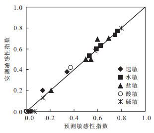
In order to determine the affecting factors and to build the predicating model of sensitivity in Luxiang depression, this paper firstly analyzes the sensitivity results and some parameters, including porosity, permeability, contents of different kinds of clay minerals tested in laboratory. Then it analyzes the relationship between sensitivity and porosity, permeability, contents of different kinds of clay minerals, throat type, and the distribution of clay minerals, integrated with the lab methods, such as core casting slices, microscope scanning, etc. Next, parameter prediction models are built by relating with sedimentary facies and depth. The porosity, permeability, contents of different clays, contents of quartz and feldspar were predicted based on these models which were used for sensitivity prediction. At last, sensitivity predicating models are built for speed sensitivity, water sensitivity, acid sensitivity and alkali sensitivity using Elman neural network. Results show that the Elman is efficient in sensitivity prediction; there are strong speed sensitivity, acid sensitivity, alkali sensitivity and salt sensitivity in Wuxing structural zone; whereas there is strong speed sensitivity in the center and northwest of Luxiang depression.
In order to determine the affecting factors and to build the predicating model of sensitivity in Luxiang depression, this paper firstly analyzes the sensitivity results and some parameters, including porosity, permeability, contents of different kinds of clay minerals tested in laboratory. Then it analyzes the relationship between sensitivity and porosity, permeability, contents of different kinds of clay minerals, throat type, and the distribution of clay minerals, integrated with the lab methods, such as core casting slices, microscope scanning, etc. Next, parameter prediction models are built by relating with sedimentary facies and depth. The porosity, permeability, contents of different clays, contents of quartz and feldspar were predicted based on these models which were used for sensitivity prediction. At last, sensitivity predicating models are built for speed sensitivity, water sensitivity, acid sensitivity and alkali sensitivity using Elman neural network. Results show that the Elman is efficient in sensitivity prediction; there are strong speed sensitivity, acid sensitivity, alkali sensitivity and salt sensitivity in Wuxing structural zone; whereas there is strong speed sensitivity in the center and northwest of Luxiang depression.


2012, 37(4): 728-734.
doi: 10.3799/dqkx.2012.081
Abstract:
Exploration clue taking hydrocarbon-rich depression was completed in oil and gas exploration of rifted lake basin, such as: "sag-wide oil-bearing" theory, oil and gas distribution "complementarity" principle and so on, and summed up a lot of laws of oil and gas enrichment. Nanpu sag was a small-scale hydrocarbon-rich depression, which was great rich resources while complicated, structure or sequence-lithologic reservoir could be formed in the whole sag. All of these reservoirs were distributed according to complementarity feature of hydrocarbon distribution. Analyzing and finding that hydrocarbon reservoirs were mainly distributed in the deep part in the north of Gaoliu fault, while mainly in the south of it. If there was no oil founded in the structure traps, lithology traps nearby could be the important aims.
Exploration clue taking hydrocarbon-rich depression was completed in oil and gas exploration of rifted lake basin, such as: "sag-wide oil-bearing" theory, oil and gas distribution "complementarity" principle and so on, and summed up a lot of laws of oil and gas enrichment. Nanpu sag was a small-scale hydrocarbon-rich depression, which was great rich resources while complicated, structure or sequence-lithologic reservoir could be formed in the whole sag. All of these reservoirs were distributed according to complementarity feature of hydrocarbon distribution. Analyzing and finding that hydrocarbon reservoirs were mainly distributed in the deep part in the north of Gaoliu fault, while mainly in the south of it. If there was no oil founded in the structure traps, lithology traps nearby could be the important aims.


2012, 37(4): 735-742.
doi: 10.3799/dqkx.2012.082
Abstract:
As the regional stress field transferred from extension to compression in the Triassic, a large-scale down-warped lacustrine basin developed in the interior Tarim basin. According to seismic sequence interpretation, four third-order sequences were identified in the Triassic. Both top and bottom surfaces of the Triassic were regional truncation unconformities. Besides a few terminal types of truncate, up-lap and incised valley, top-lap was the widespread mark of sequence boundary. Furthermore, sequences correlations among wells reveals that sequences were very special in depositional evolutions as follows: in their lake-expanding systems tracts, large-scale braided river deltas had usually developed with coarse sediment and thick sandbodies; contrarily, in their high-stand systems tracts, the deltas were small with much finer sediments. Presumedly, stratigraphic sequences were dominated by episodic compressive tectonism, which gradually intensified and then weakened. Responding to violently compressive action in lake-expanding systems tracts, the lithosphere had flexed and as a result the basin rapidly expanded; on the other hand, the surrounding forebulges and orogenic belts had intensely uplifted, and the sediment supplies had been largely accelerated so that it exceeded the accommodation increment which caused that the braided river deltas had extensively developed.
As the regional stress field transferred from extension to compression in the Triassic, a large-scale down-warped lacustrine basin developed in the interior Tarim basin. According to seismic sequence interpretation, four third-order sequences were identified in the Triassic. Both top and bottom surfaces of the Triassic were regional truncation unconformities. Besides a few terminal types of truncate, up-lap and incised valley, top-lap was the widespread mark of sequence boundary. Furthermore, sequences correlations among wells reveals that sequences were very special in depositional evolutions as follows: in their lake-expanding systems tracts, large-scale braided river deltas had usually developed with coarse sediment and thick sandbodies; contrarily, in their high-stand systems tracts, the deltas were small with much finer sediments. Presumedly, stratigraphic sequences were dominated by episodic compressive tectonism, which gradually intensified and then weakened. Responding to violently compressive action in lake-expanding systems tracts, the lithosphere had flexed and as a result the basin rapidly expanded; on the other hand, the surrounding forebulges and orogenic belts had intensely uplifted, and the sediment supplies had been largely accelerated so that it exceeded the accommodation increment which caused that the braided river deltas had extensively developed.


2012, 37(4): 743-750.
doi: 10.3799/dqkx.2012.083
Abstract:
Special sequence stratigraphic framework formed in the foreland basin due to its unique tectonic and sedimentary background. In this paper, the sequence patterns in orogenic front uplift belt are discussed taking an example of the Chepaizi area, western Junggar basin. Five key chronohorizons are identified in Mesozoic-Cenozoic sedimentary intervals (Tugulu Group of Lower Crataceous, Anjihaihe Group of Paleogene, Shawan Group and Taxihe Group of Neogene) in the study area. According to the features and orders of the sequence boundaries, two first-order sequences, three second-order sequences and four third-order sequences are divided. Controlled by the special orogenic front uplift slope depositional setting in foreland basin and multiple episodic thrusting processes, the Mesozoic-Cenozoic sequences show two contrasting segments of sequence architecture with only lowstand system tract and transgressive system tract in the Chepaizi area. Coarser grain deposits developed in lowstand system tract during thrusting period, and finer grain deposits developed in transgressive system tract during tectonic relaxing period. The lowstand incised valleys, large scale fan deltas and transgressive beach sandbars are the mainly favorable reservoir rocks and exploration targets.
Special sequence stratigraphic framework formed in the foreland basin due to its unique tectonic and sedimentary background. In this paper, the sequence patterns in orogenic front uplift belt are discussed taking an example of the Chepaizi area, western Junggar basin. Five key chronohorizons are identified in Mesozoic-Cenozoic sedimentary intervals (Tugulu Group of Lower Crataceous, Anjihaihe Group of Paleogene, Shawan Group and Taxihe Group of Neogene) in the study area. According to the features and orders of the sequence boundaries, two first-order sequences, three second-order sequences and four third-order sequences are divided. Controlled by the special orogenic front uplift slope depositional setting in foreland basin and multiple episodic thrusting processes, the Mesozoic-Cenozoic sequences show two contrasting segments of sequence architecture with only lowstand system tract and transgressive system tract in the Chepaizi area. Coarser grain deposits developed in lowstand system tract during thrusting period, and finer grain deposits developed in transgressive system tract during tectonic relaxing period. The lowstand incised valleys, large scale fan deltas and transgressive beach sandbars are the mainly favorable reservoir rocks and exploration targets.


2012, 37(4): 751-762.
doi: 10.3799/dqkx.2012.084
Abstract:
The Yingshan Formation of Middle-Lower Ordovician in Tazhong uplift in Tarim is an important fracture and karst-modified carbonate reservoir. Main pore types in this reservoir include fractures, vug and caves, which mainly resulted from multi-stage epigenetic dissolution and post-stage hypogenetic excavation. The reservoir architectural systems are of extreme heterogeneity and significant compartmentalization. This study presents an architectural hierarchy for the reservoirs not controlled by facices according to the system theory. On the basis of integrated information revealed by a variety of methods, such as geophysical methods including prestack fracture prediction technology, paleo-geomorphological analysis technology, seismic-logging wave impedance inversion technology, three-dimensional seismic attribute extraction technology, and well-logging explanation, core observation etc, the four types of reservoir units including fracture-dominated, vug-dominated, cave-dominated and complex can be identified and mapped in this area, these reservoir architectural units genetically formed in epigenetic and hydrothermal karst modification, fracturing. Moreover, the genesis of some reservoir units are studied in detail.
The Yingshan Formation of Middle-Lower Ordovician in Tazhong uplift in Tarim is an important fracture and karst-modified carbonate reservoir. Main pore types in this reservoir include fractures, vug and caves, which mainly resulted from multi-stage epigenetic dissolution and post-stage hypogenetic excavation. The reservoir architectural systems are of extreme heterogeneity and significant compartmentalization. This study presents an architectural hierarchy for the reservoirs not controlled by facices according to the system theory. On the basis of integrated information revealed by a variety of methods, such as geophysical methods including prestack fracture prediction technology, paleo-geomorphological analysis technology, seismic-logging wave impedance inversion technology, three-dimensional seismic attribute extraction technology, and well-logging explanation, core observation etc, the four types of reservoir units including fracture-dominated, vug-dominated, cave-dominated and complex can be identified and mapped in this area, these reservoir architectural units genetically formed in epigenetic and hydrothermal karst modification, fracturing. Moreover, the genesis of some reservoir units are studied in detail.


2012, 37(4): 763-770.
doi: 10.3799/dqkx.2012.085
Abstract:
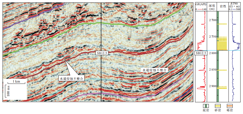
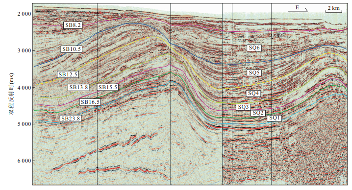
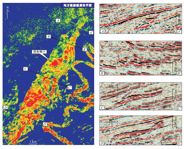
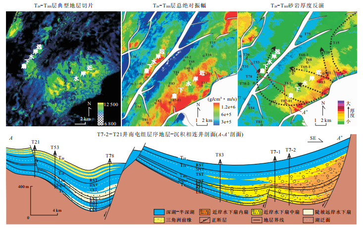
The research of deepwater sedimentary systems in the Niger Delta basin is one of the key issues in hydrocarbon exploration in the world. According to the analysis of 3D seismic data, well, core, sedimentary structure and logs characters, depositional characteristics of deepwater systems are discussed on Neocene in the south of Niger Delta basin. Sequence stratigraphic framework is established based on identification of sequence boundary and 6 third-order sequences are divided and named as SQ1-SQ6. The depositional models of deepwater sedimentary systems are established. Three kinds of depositional facies are identified in the deepwater sedimentary systems, namely, turbidite channel, submarine lobe and hemipelagic mudstones. Channel only has few branches that are highly sinuous, with morphology similar to that of meandering river; submarine lobes can be divided into terminal lobe and crevasse splay lobe. During the Neocene deposition from the SQ1 to the SQ6, relative sea level firstly fell and then rose, submarine lobe facies developed in the SQ1-SQ4 and turbidite channel facies developed in the SQ5-SQ6.
The research of deepwater sedimentary systems in the Niger Delta basin is one of the key issues in hydrocarbon exploration in the world. According to the analysis of 3D seismic data, well, core, sedimentary structure and logs characters, depositional characteristics of deepwater systems are discussed on Neocene in the south of Niger Delta basin. Sequence stratigraphic framework is established based on identification of sequence boundary and 6 third-order sequences are divided and named as SQ1-SQ6. The depositional models of deepwater sedimentary systems are established. Three kinds of depositional facies are identified in the deepwater sedimentary systems, namely, turbidite channel, submarine lobe and hemipelagic mudstones. Channel only has few branches that are highly sinuous, with morphology similar to that of meandering river; submarine lobes can be divided into terminal lobe and crevasse splay lobe. During the Neocene deposition from the SQ1 to the SQ6, relative sea level firstly fell and then rose, submarine lobe facies developed in the SQ1-SQ4 and turbidite channel facies developed in the SQ5-SQ6.


2012, 37(4): 771-778.
doi: 10.3799/dqkx.2012.086
Abstract:
The strata of Nantun Formation in Ta nan sag of Mongolia developed a great number of offshore subaqueous fan deposits, which has been determined to have been formed by the supplying source of steep slope of the basin according to the synthetically analysis of the petrologic characteristics, the heavy mineral assemblages and the seismic data, and it is also found out that this subaqueous fan is a kind of infrequent steep-slope offshore subaqueous fan. On the basis of the summary of the seismic, logging and core features, the offshore subaqueous fan can be divided into four kinds of sub-facies (supply channel, inner fan, middle-fan, and outer fan respectively) and several micro facies, and there are significantly different characteristics between different facies belts.The steep-slope offshore subaqueous fan spread along the central fault in the form of string beadings and developed in low stand system tract, transgressive system tract and regressive system. The formation and evolution of the steep-slope offshore subaqueous fan were commonly controlled by three factors, namely, sediment supply, ancient landform and tectonic movement. Despite its poor reservoir properties, amounts of lithologic reservoirs and tectonic-lithologic combined reservoirs often formed in the system owing to the surrounding high pressure dark mudstone. It was influenced by the incontinuous deposition as well as the inner heterogeneity of layers.The reservoirs of the steep offshore subaqueous fan usually are featured with more oil layers, thin single oil layers and different oiliness levels in different layers.
The strata of Nantun Formation in Ta nan sag of Mongolia developed a great number of offshore subaqueous fan deposits, which has been determined to have been formed by the supplying source of steep slope of the basin according to the synthetically analysis of the petrologic characteristics, the heavy mineral assemblages and the seismic data, and it is also found out that this subaqueous fan is a kind of infrequent steep-slope offshore subaqueous fan. On the basis of the summary of the seismic, logging and core features, the offshore subaqueous fan can be divided into four kinds of sub-facies (supply channel, inner fan, middle-fan, and outer fan respectively) and several micro facies, and there are significantly different characteristics between different facies belts.The steep-slope offshore subaqueous fan spread along the central fault in the form of string beadings and developed in low stand system tract, transgressive system tract and regressive system. The formation and evolution of the steep-slope offshore subaqueous fan were commonly controlled by three factors, namely, sediment supply, ancient landform and tectonic movement. Despite its poor reservoir properties, amounts of lithologic reservoirs and tectonic-lithologic combined reservoirs often formed in the system owing to the surrounding high pressure dark mudstone. It was influenced by the incontinuous deposition as well as the inner heterogeneity of layers.The reservoirs of the steep offshore subaqueous fan usually are featured with more oil layers, thin single oil layers and different oiliness levels in different layers.


2012, 37(4): 779-790.
doi: 10.3799/dqkx.2012.087
Abstract:
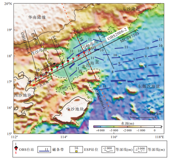
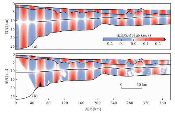
Deep crustal structure in the northwest sub-basin contains the key information of the rifting process of the northern continental margin of the South China Sea (SCS). A 386 km-long seismic profile (OBS2006-2) with wide-angle reflective and refractive ocean bottom seismometer (OBS) data was acquired across Xisha block and the Northwest sub-basin (NW sub-basin) of the SCS in NEE direction, which is the only profile hitherto parallel to the expanding ridge of the NW sub-basin. The crustal structure along OBS2006-2 has been obtained by using ray-tracing simulation method (RAYINVR), which yields information on the velocities, tectonics, and geophysical properties. Our velocity structure indicates that sediment thickness increases from Xisha block (about 1-2 km) to NW sub-basin (about 2-3 km). Moho interface changes from typical continent margin of South China (~27 km) to oceanic crust (~12 km). The velocity at the top of upper mantle varies from 7.8 to 8.0 km/s. No high velocity layer and low velocity layer have been identified. Voluminous magmatism in transition zone between Xisha block and NW sub-basin, is possibly related to the initial extending of the NW sub-basin. The part of model in the domain of 220-370 km would be of oceanic crust while the western part in the domain of 0-220 km may be of thinned continental crust. Residual magma may exist under the speading ridge of the NW sub-basin deduced by the anomaly of Pn seismic phase.
Deep crustal structure in the northwest sub-basin contains the key information of the rifting process of the northern continental margin of the South China Sea (SCS). A 386 km-long seismic profile (OBS2006-2) with wide-angle reflective and refractive ocean bottom seismometer (OBS) data was acquired across Xisha block and the Northwest sub-basin (NW sub-basin) of the SCS in NEE direction, which is the only profile hitherto parallel to the expanding ridge of the NW sub-basin. The crustal structure along OBS2006-2 has been obtained by using ray-tracing simulation method (RAYINVR), which yields information on the velocities, tectonics, and geophysical properties. Our velocity structure indicates that sediment thickness increases from Xisha block (about 1-2 km) to NW sub-basin (about 2-3 km). Moho interface changes from typical continent margin of South China (~27 km) to oceanic crust (~12 km). The velocity at the top of upper mantle varies from 7.8 to 8.0 km/s. No high velocity layer and low velocity layer have been identified. Voluminous magmatism in transition zone between Xisha block and NW sub-basin, is possibly related to the initial extending of the NW sub-basin. The part of model in the domain of 220-370 km would be of oceanic crust while the western part in the domain of 0-220 km may be of thinned continental crust. Residual magma may exist under the speading ridge of the NW sub-basin deduced by the anomaly of Pn seismic phase.


2012, 37(4): 791-804.
doi: 10.3799/dqkx.2012.088
Abstract:
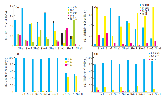
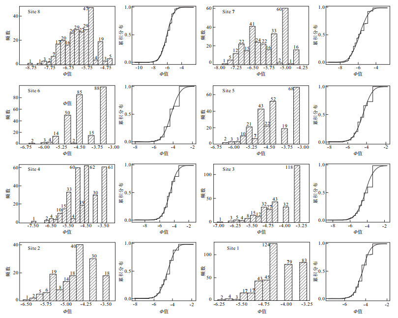
The study of gravel-facies, an important sedimentary indicator of tectonic event could facilitate the understanding of the evolution of the uplift in orogen. In this paper, the Cenozoic gravels in Oytag section located in the piedmont of northeastern Pamir, has been chosen to conduct gravel counting. The results show that gravels in Cenozoic are mainly igneous and metamorphic, indicating that they came from Pamir area. As the first occurrence of new gravel types, the granite gravel emerges at the bottom of Atushi Formation of Pliocene. The gravels are mainly of giant-size, sub-rounded and sub-angular, moderated and middling to bad sorted, with a ratio of the length of maximum axis to the minimum axis ranging from 1 to 2. Combined with Cenozoic depositing environment and thermochronology records, following uplifting periods have been identified in northeastern Pamir as Late Oligocene to Early Miocene, Mid Miocene and since Early Pliocene.
The study of gravel-facies, an important sedimentary indicator of tectonic event could facilitate the understanding of the evolution of the uplift in orogen. In this paper, the Cenozoic gravels in Oytag section located in the piedmont of northeastern Pamir, has been chosen to conduct gravel counting. The results show that gravels in Cenozoic are mainly igneous and metamorphic, indicating that they came from Pamir area. As the first occurrence of new gravel types, the granite gravel emerges at the bottom of Atushi Formation of Pliocene. The gravels are mainly of giant-size, sub-rounded and sub-angular, moderated and middling to bad sorted, with a ratio of the length of maximum axis to the minimum axis ranging from 1 to 2. Combined with Cenozoic depositing environment and thermochronology records, following uplifting periods have been identified in northeastern Pamir as Late Oligocene to Early Miocene, Mid Miocene and since Early Pliocene.


2012, 37(4): 805-814.
doi: 10.3799/dqkx.2012.089
Abstract:
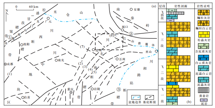
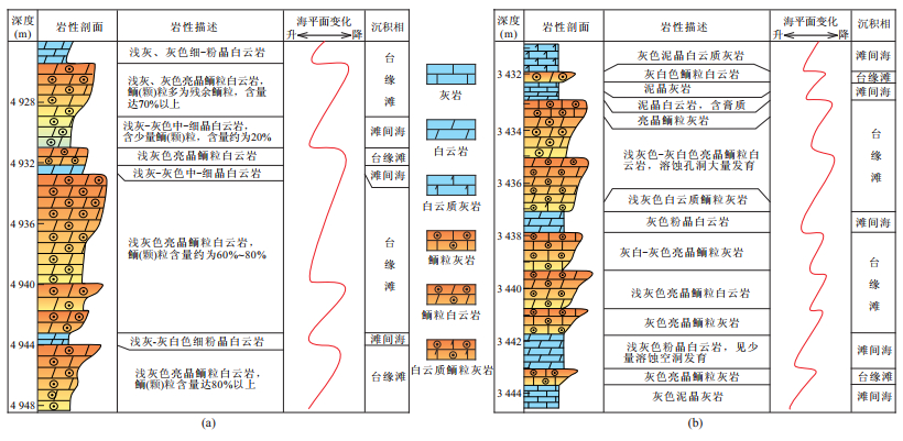
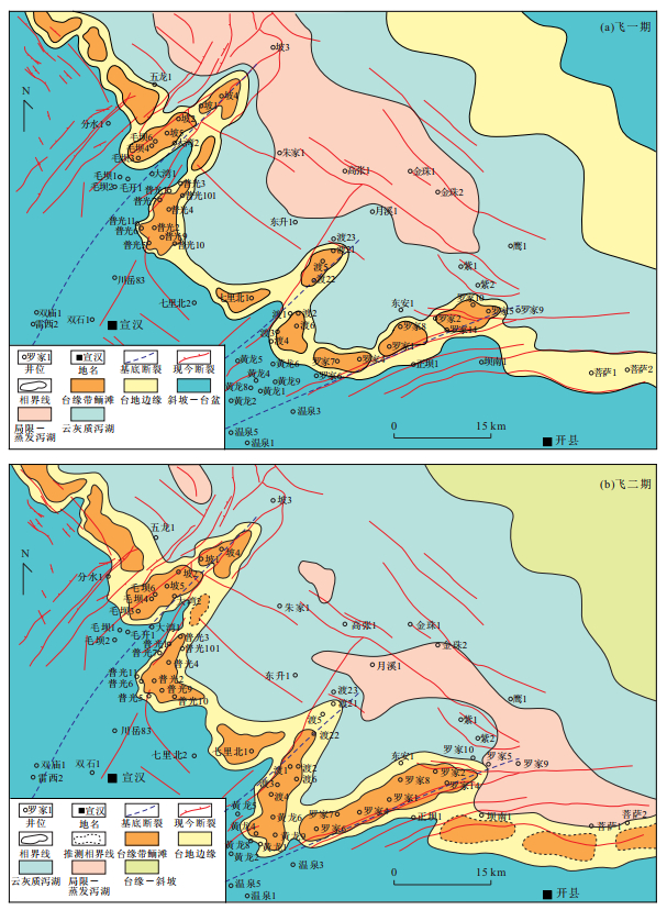
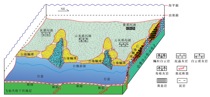
To better probe the laws of distribution of oolitic shoal which lies in the platform margin of Feixianguan Formation, Sichuan basin to facilitate the exploration and development on the oolitic shoal gas pool, this paper analyses the development properties and distribution law of platform margin shoal by means of case study of northeastern region of Sichuan basin, after which it points out that this type of oolitic shoal expands in the direction of NW-SE along the platform margin and stretches in "finger-shape" to the platform interior from which two groups of positive faults basement cross in directions of NE and NW, while the extension direction of the "finger-shape" is vertical to the platform margin. Furthermore, paleogeography framework formed by syndepositional activities of basement cracking, sedimentary paleogeomorphology and relative sea level change dominates the longitudinal and horizontal discipline of this oolitic shoal jointly. First, syndepositional tension of basement cracking in the direction NW contributes to the sedimentary framework of platform-hollow differentiation, which simultaneously controls the distribution of platform margin and also facies of oolitic shoal on it., while that of NE one aggravates the degree of differentiation of sedimentary geomorphy in the researching area. Oolitic shoal of platform margin occurs on the "cracking uplift" highland formed by the basement cracking in the direction of NE-SW, which migrates to the internal platform, characterized by the fault controlling oolitic shoal of platform margin fingered slim zone of "belts dominated by NW, decorated by NE". Second, the relative eustasy regulates sedimentary thickness and scale. Consequently an integration model of multi-factor on the shoal of platform margin can be established eventually.
To better probe the laws of distribution of oolitic shoal which lies in the platform margin of Feixianguan Formation, Sichuan basin to facilitate the exploration and development on the oolitic shoal gas pool, this paper analyses the development properties and distribution law of platform margin shoal by means of case study of northeastern region of Sichuan basin, after which it points out that this type of oolitic shoal expands in the direction of NW-SE along the platform margin and stretches in "finger-shape" to the platform interior from which two groups of positive faults basement cross in directions of NE and NW, while the extension direction of the "finger-shape" is vertical to the platform margin. Furthermore, paleogeography framework formed by syndepositional activities of basement cracking, sedimentary paleogeomorphology and relative sea level change dominates the longitudinal and horizontal discipline of this oolitic shoal jointly. First, syndepositional tension of basement cracking in the direction NW contributes to the sedimentary framework of platform-hollow differentiation, which simultaneously controls the distribution of platform margin and also facies of oolitic shoal on it., while that of NE one aggravates the degree of differentiation of sedimentary geomorphy in the researching area. Oolitic shoal of platform margin occurs on the "cracking uplift" highland formed by the basement cracking in the direction of NE-SW, which migrates to the internal platform, characterized by the fault controlling oolitic shoal of platform margin fingered slim zone of "belts dominated by NW, decorated by NE". Second, the relative eustasy regulates sedimentary thickness and scale. Consequently an integration model of multi-factor on the shoal of platform margin can be established eventually.

2012, 37(4): 815-824.
doi: 10.3799/dqkx.2012.090
Abstract:
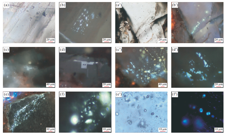
The composition information of individual oil inclusion is not only important for quantitatively understanding the maturity evolution of petroleum during the petroleum charging, but also significant for the precise depiction of the dynamic evolution during petroleum accumulation. However, it is very difficult to obtain the detailed composition of individual petroleum inclusion directly by experimental methods. Petroleum inclusions thermodynamics method is an easy and fast indirect method for obtaining the individual petroleum inclusion composition which has been well developed in last ten years. Ten oil composition data with different maturity are used to build the standard relation diagram of oil inclusions homogenization temperature (Thoil) and the degree of gaseous filling (Fv) at room temperature (20 ℃) using petroleum inclusions thermodynamics method on condition that firstly, match the saturation pressure and improvement of the gas and liquid mole volume calculations, then the equivalent composition can be determined by comparing the measured homogenization temperature and the degree of gaseous filling at room temperature (20 ℃) with the standard Thoil-Fv diagram. The compositions of petroleum inclusions with different maturity are quantified by a series of measurements on oil inclusions in the deeply buried reservoir in Minfeng area in North Dongying depression including fluorescence analysis, microthermometry and 3D reconstruction of the oil inclusions volume. The results show that both of the well Feng 8 and well Fengshen 1 happened two episodes of petroleum charging events. The first episode oil charging whose methane mole percent content is between 31%-35% contributed to the petroleum accumulation of well Feng 8, and the second episode oil whose methane mole percent content is more than 60% controlled the gas condensate accumulation of well Fengshen 1. The composition prediction results facilitates further establishing the oil and gas charging PVTxt history in the deeply buried reservoir in Minfeng area in North Dongying depression.
The composition information of individual oil inclusion is not only important for quantitatively understanding the maturity evolution of petroleum during the petroleum charging, but also significant for the precise depiction of the dynamic evolution during petroleum accumulation. However, it is very difficult to obtain the detailed composition of individual petroleum inclusion directly by experimental methods. Petroleum inclusions thermodynamics method is an easy and fast indirect method for obtaining the individual petroleum inclusion composition which has been well developed in last ten years. Ten oil composition data with different maturity are used to build the standard relation diagram of oil inclusions homogenization temperature (Thoil) and the degree of gaseous filling (Fv) at room temperature (20 ℃) using petroleum inclusions thermodynamics method on condition that firstly, match the saturation pressure and improvement of the gas and liquid mole volume calculations, then the equivalent composition can be determined by comparing the measured homogenization temperature and the degree of gaseous filling at room temperature (20 ℃) with the standard Thoil-Fv diagram. The compositions of petroleum inclusions with different maturity are quantified by a series of measurements on oil inclusions in the deeply buried reservoir in Minfeng area in North Dongying depression including fluorescence analysis, microthermometry and 3D reconstruction of the oil inclusions volume. The results show that both of the well Feng 8 and well Fengshen 1 happened two episodes of petroleum charging events. The first episode oil charging whose methane mole percent content is between 31%-35% contributed to the petroleum accumulation of well Feng 8, and the second episode oil whose methane mole percent content is more than 60% controlled the gas condensate accumulation of well Fengshen 1. The composition prediction results facilitates further establishing the oil and gas charging PVTxt history in the deeply buried reservoir in Minfeng area in North Dongying depression.


2012, 37(4): 825-832.
doi: 10.3799/dqkx.2012.091
Abstract:
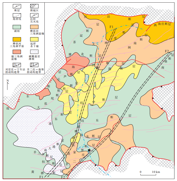
The Qikou sag at the central of the Bohai bay basin lies in the superimposition of the extension and strike-slip, and is controlled by the eastern boundary Tanlu fault and the western boundary Taihang Mountain-front strike-slip fault. Through the detailed structural research of the latest large area 3D high precision seismic data, the wrench structures were found as well as the extensional structures in the Paleogene cover of the Qikou sag. On the seismic profiles, the wrench structure can be divided into four types based on the different combination styles of the faults in the basement and the Tertiary cover. They are the slip-complex faulted fold type, slip-simple flower structure type, thrust-simple flower structure type and the slip-deflecting fold type. Meanwhile, the wrench structure not only improved the physical property of the basement rock but also controlled the entrance of the ancient resource and the distribution of the sand. Different reservoirs formed in the pre-Tertiary, Paleogene and Neogene tectospheres. The Paleogene deflecting folds, huge faulted-noses and litho-stratigraphic reservoirs are important exploration fields and the same case with the Neogene reverse drag anticline and the flank of the faulted-noses. The research of the wrench belts is significant for the theory and practice because of the important petroleum exploration success beside the wrench structure belts in last two years.
The Qikou sag at the central of the Bohai bay basin lies in the superimposition of the extension and strike-slip, and is controlled by the eastern boundary Tanlu fault and the western boundary Taihang Mountain-front strike-slip fault. Through the detailed structural research of the latest large area 3D high precision seismic data, the wrench structures were found as well as the extensional structures in the Paleogene cover of the Qikou sag. On the seismic profiles, the wrench structure can be divided into four types based on the different combination styles of the faults in the basement and the Tertiary cover. They are the slip-complex faulted fold type, slip-simple flower structure type, thrust-simple flower structure type and the slip-deflecting fold type. Meanwhile, the wrench structure not only improved the physical property of the basement rock but also controlled the entrance of the ancient resource and the distribution of the sand. Different reservoirs formed in the pre-Tertiary, Paleogene and Neogene tectospheres. The Paleogene deflecting folds, huge faulted-noses and litho-stratigraphic reservoirs are important exploration fields and the same case with the Neogene reverse drag anticline and the flank of the faulted-noses. The research of the wrench belts is significant for the theory and practice because of the important petroleum exploration success beside the wrench structure belts in last two years.


2012, 37(4): 833-842.
doi: 10.3799/dqkx.2012.092
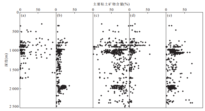
Abstract:
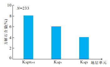
There are 3 sets of obvious overpressure systems in the strata above the Qingshankou Formation in Qijiagulong-Sanzhao depression, Songliao basin. The overpressure in the Qingshankou (K2qn) and Nenjiang (K2n) Formation mud rock which is the key zone of exploration which not only controls the formation of hydrocarbon, but also impacts the adjacent reservoir property deeply. Based on the previous studies, this paper utilizes abundant materials, including thermal decomposition, X-ray diffraction, microscope analysis, SEM and blue epoxy resin-impregnated thin sections, to study the effect of overpressure on diagenesis. The results indicate: (1) the overpressure constrained the transformation of clay minerals, and also depressed the evolution of hydrocarbon structure. (2) The compaction and cementation during diagenesis responded apparently to the overpressure depression. The overpressure didn't affects dissolution directly, but via the geo-fluids indirectly, causing the increase of porosity by induced pore.
There are 3 sets of obvious overpressure systems in the strata above the Qingshankou Formation in Qijiagulong-Sanzhao depression, Songliao basin. The overpressure in the Qingshankou (K2qn) and Nenjiang (K2n) Formation mud rock which is the key zone of exploration which not only controls the formation of hydrocarbon, but also impacts the adjacent reservoir property deeply. Based on the previous studies, this paper utilizes abundant materials, including thermal decomposition, X-ray diffraction, microscope analysis, SEM and blue epoxy resin-impregnated thin sections, to study the effect of overpressure on diagenesis. The results indicate: (1) the overpressure constrained the transformation of clay minerals, and also depressed the evolution of hydrocarbon structure. (2) The compaction and cementation during diagenesis responded apparently to the overpressure depression. The overpressure didn't affects dissolution directly, but via the geo-fluids indirectly, causing the increase of porosity by induced pore.


2012, 37(4): 843-850.
doi: 10.3799/dqkx.2012.093
Abstract:
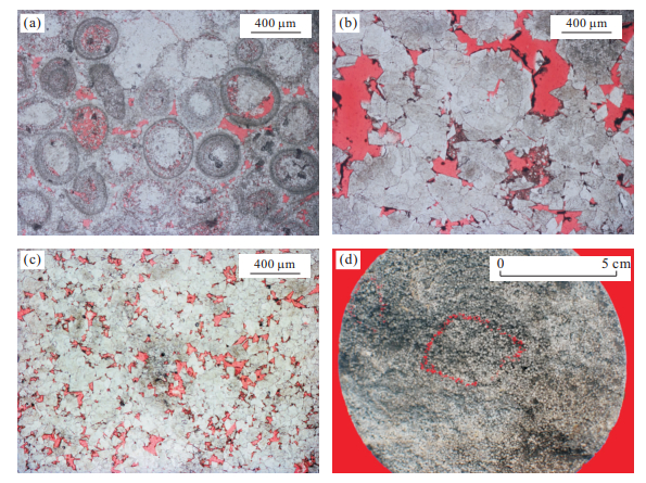
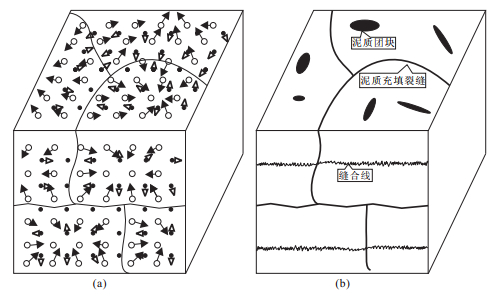
Through Paleontology appraisal, outcrop contrast and under mirror slice observation methods, this paper analyzes the causes of reticular cracks, Baota Formation limestone, Ordovician. Paleontology is mainly of cephalopods (Sinoceras chinensis), trilobites, ostracoda and echinodermata (Metacrinus), occasionally including Brachiopoda, noalga. The formation is divided into two units: the lower purple and the upper celadon. The crack, stretching from the surface and bottom without penetrating the adjacent formation, stops when extended to the biological fossils. The patterns are of nodular, tortoise shell and the S curve, etc; dentate suture lines cut through the crack. Microscopic study shows that shale mass spreads in the limy matrices, with shale mass connected each other or connected to the main crack by the micro crack, the macroaxis of the limy chipping in shale exhibited along the crack. There are no obvious boundaries between limy matrices and shale crack in fresh profile. It is concluded that the Yangtze plate, Baota period was in a stable craton sedimentary environment, and reticular cracks formed due to limy particles by chemical differentiation and clay mineral syneresis in compressions with shale filling cracks with no-flow periods in a deep water(more than euphotic zone) slow deposition low-energy open platform environment, which indicates that cracks formed because of the non-structural causes.
Through Paleontology appraisal, outcrop contrast and under mirror slice observation methods, this paper analyzes the causes of reticular cracks, Baota Formation limestone, Ordovician. Paleontology is mainly of cephalopods (Sinoceras chinensis), trilobites, ostracoda and echinodermata (Metacrinus), occasionally including Brachiopoda, noalga. The formation is divided into two units: the lower purple and the upper celadon. The crack, stretching from the surface and bottom without penetrating the adjacent formation, stops when extended to the biological fossils. The patterns are of nodular, tortoise shell and the S curve, etc; dentate suture lines cut through the crack. Microscopic study shows that shale mass spreads in the limy matrices, with shale mass connected each other or connected to the main crack by the micro crack, the macroaxis of the limy chipping in shale exhibited along the crack. There are no obvious boundaries between limy matrices and shale crack in fresh profile. It is concluded that the Yangtze plate, Baota period was in a stable craton sedimentary environment, and reticular cracks formed due to limy particles by chemical differentiation and clay mineral syneresis in compressions with shale filling cracks with no-flow periods in a deep water(more than euphotic zone) slow deposition low-energy open platform environment, which indicates that cracks formed because of the non-structural causes.


2012, 37(4): 851-859.
doi: 10.3799/dqkx.2012.094
Abstract:
A set of rocks between volcanic lava and normal sedimentary clastic rock were developed in Lower Cretaceous of Wuerxun and Bei'er depression in Hailaer basin. Compared with normal sedimentary rocks, their diagenesis types are particular. The methods of description of microscopic sections and scanning electron microscope (sem) are used to research the diagenesis types, and to summarize succession of diagenesis. The results show that types of pyroclastic rocks diagenesis include weldition, mechanical percolation, compaction, devitrification, recrystallization, cementation, transformation of neogenic mineral and dissolution. Weldition, devitrification and dissolution of tuffaceous matter are specific diagenesis types in pyroclastic rocks. There are four typical diagenetic paragenetic associations which have genetic relationships, including (1) microcrystalline quartz and microcrystalline calcite; (2) quartz dissolution and crystallization; (3) authigenic muscovite; smectite; illite and chlorite; (4) zeolite and authigenic feldspar. The order succession of diagenesis is as follows: weldition, mechanical percolation, devitrification, dissolution of tuffaceous matter, claymineral mixed layer, authigenic muscovite, zeolite cementation, particles strong cementation and ankerite. The diagenesis stage of Wuerxun in Lower Cretaceous ranges from early diagenetic B to late diagenetic B. The main stage is late diagenetic A.
A set of rocks between volcanic lava and normal sedimentary clastic rock were developed in Lower Cretaceous of Wuerxun and Bei'er depression in Hailaer basin. Compared with normal sedimentary rocks, their diagenesis types are particular. The methods of description of microscopic sections and scanning electron microscope (sem) are used to research the diagenesis types, and to summarize succession of diagenesis. The results show that types of pyroclastic rocks diagenesis include weldition, mechanical percolation, compaction, devitrification, recrystallization, cementation, transformation of neogenic mineral and dissolution. Weldition, devitrification and dissolution of tuffaceous matter are specific diagenesis types in pyroclastic rocks. There are four typical diagenetic paragenetic associations which have genetic relationships, including (1) microcrystalline quartz and microcrystalline calcite; (2) quartz dissolution and crystallization; (3) authigenic muscovite; smectite; illite and chlorite; (4) zeolite and authigenic feldspar. The order succession of diagenesis is as follows: weldition, mechanical percolation, devitrification, dissolution of tuffaceous matter, claymineral mixed layer, authigenic muscovite, zeolite cementation, particles strong cementation and ankerite. The diagenesis stage of Wuerxun in Lower Cretaceous ranges from early diagenetic B to late diagenetic B. The main stage is late diagenetic A.


2012, 37(4): 860-868.
doi: 10.3799/dqkx.2012.095
Abstract:
Based on the measured temperature, pressure and acoustic log data of more than two hundred wells, the distribution characteristics of geothermal field, geopressure field and the geothermal-geopressure system of the Qianjiang Formation in the Qianjiang depression are analyzed by using the theory of geothermal-geopressure system. The relationship between the systems with petroleum accumulation is also discussed from the perspectives of hydrocarbon generation, preservation and distribution. This research comes to the following results: The Banghu and Zhouji syncline belts have higher geothermal gradient, which is favorable to the maturation of the Qianjiang Formation source rock expulsion. The present pressures of the Qianjiang Formation and stones mostly belong to normal range, whereas the deep Qianjiang Formation mudstones present uncompaction which enhanced its seal ability. In vertical, the T-P system of the Qianjiang Formation includes two kinds of static pressure and overpressure. The static pressure systems mainly distribute at the Qianbei steep slope belt, the eastern slope belt and the western slope belt where the reservoirs were formed by self-generation and self-storage, whereas the overpressure systems exist in the Banghu and Zhouji syncline belts where the reservoirs are distributed mostly at the top of the deep overpressure system and within the shallower normal pressure system. The lateral T-P systems can be divided into 8 subareas, namely, NTHP, LTHP, HTNP, NTNP, LTNP, HTLP, NTLP and LTLP, and the NTNP is the place where petroleum mainly accumulated.
Based on the measured temperature, pressure and acoustic log data of more than two hundred wells, the distribution characteristics of geothermal field, geopressure field and the geothermal-geopressure system of the Qianjiang Formation in the Qianjiang depression are analyzed by using the theory of geothermal-geopressure system. The relationship between the systems with petroleum accumulation is also discussed from the perspectives of hydrocarbon generation, preservation and distribution. This research comes to the following results: The Banghu and Zhouji syncline belts have higher geothermal gradient, which is favorable to the maturation of the Qianjiang Formation source rock expulsion. The present pressures of the Qianjiang Formation and stones mostly belong to normal range, whereas the deep Qianjiang Formation mudstones present uncompaction which enhanced its seal ability. In vertical, the T-P system of the Qianjiang Formation includes two kinds of static pressure and overpressure. The static pressure systems mainly distribute at the Qianbei steep slope belt, the eastern slope belt and the western slope belt where the reservoirs were formed by self-generation and self-storage, whereas the overpressure systems exist in the Banghu and Zhouji syncline belts where the reservoirs are distributed mostly at the top of the deep overpressure system and within the shallower normal pressure system. The lateral T-P systems can be divided into 8 subareas, namely, NTHP, LTHP, HTNP, NTNP, LTNP, HTLP, NTLP and LTLP, and the NTNP is the place where petroleum mainly accumulated.