2012 Vol. 37, No. 5
Display Method:
 PDF 535KB
2012, 37(5): 869-877.
doi: 10.3799/dqkx.2012.096
Abstract:
The rich phosphatized embryo fossils and a large number of small shelly fossils were found from Early Cambrian Kuanchuanpu biota in the southern Shaanxi Province. So far, only embryonic fossils of the different development stages after blastosphere have been found in the embryo fossils previously reported, with the absence of fossils of transgene embryo. This paper presents many new specimens of cleavage embryos fossils in Kuanchuanpu biota, ranging from four cells, 64 cells, 128 cells, 512 cells to classification of cells without embryo fossils of cells, as well as a number of fossil specimens developed during blastosphere period, the original embryo stage and different bowel hatch larval stage, which constituted the integrated developmental sequence of embryo from single cells (Olivooides) to blastocysts, the original embryo, and then to bowel hatch larval cone (Punctatus). The variations of these cell fossils in numbers, forms, arrangement and blastocysts cavity can be compared to those in the Wen'an biota of Guizhou belonging to Ediacaran. In addition, they can also be compared to the cleavage embryos of living Cnidaria. Here, the fossils found for the first time complement specimens of embryo fossils in Kuanchuanpu biota and reveal developmental process of Olivooides embryos. Moreover, new specimens can also provide evidences to reveal genetic relationship and early evolution of the metazoan.
The rich phosphatized embryo fossils and a large number of small shelly fossils were found from Early Cambrian Kuanchuanpu biota in the southern Shaanxi Province. So far, only embryonic fossils of the different development stages after blastosphere have been found in the embryo fossils previously reported, with the absence of fossils of transgene embryo. This paper presents many new specimens of cleavage embryos fossils in Kuanchuanpu biota, ranging from four cells, 64 cells, 128 cells, 512 cells to classification of cells without embryo fossils of cells, as well as a number of fossil specimens developed during blastosphere period, the original embryo stage and different bowel hatch larval stage, which constituted the integrated developmental sequence of embryo from single cells (Olivooides) to blastocysts, the original embryo, and then to bowel hatch larval cone (Punctatus). The variations of these cell fossils in numbers, forms, arrangement and blastocysts cavity can be compared to those in the Wen'an biota of Guizhou belonging to Ediacaran. In addition, they can also be compared to the cleavage embryos of living Cnidaria. Here, the fossils found for the first time complement specimens of embryo fossils in Kuanchuanpu biota and reveal developmental process of Olivooides embryos. Moreover, new specimens can also provide evidences to reveal genetic relationship and early evolution of the metazoan.


2012, 37(5): 878-892.
doi: 10.3799/dqkx.2012.097
Abstract:
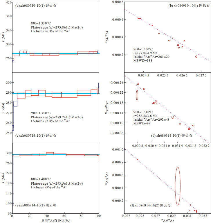
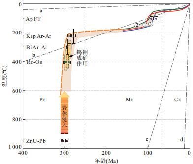
The Balkhash metallogenic belt in Kazakhstan, with many porphyritic Cu-Mo deposits and some quartz-vein greisen Mo-W deposits, is a famous porphyritic Cu-Mo metallogenic belt in Central Asian metallogenic domain. Three typical Mo-W deposits such as East Kounrad, Akshatau, and Zhanet, are studied in this paper through the application of geothermochronology. Zircon SHRIMP U-Pb geochronology yields ages of 293.6±2.7 Ma (alkaline granite), 306±1 Ma (granodiorite), and 304±4 Ma (porphyry monzonite), for East Kounrad, Akshatau, and Zhanet deposits respectively, belonging to the tectonic-magmatism in the Late Hercynian. 40Ar/39Ar thermochronology gives the cooling ages at 292±3 Ma for biotite from Akshatau, and 288.8±3.6 Ma and 278±5 Ma for K-feldspars from Akshatau and East Kounrad, respectively. Apatite fission track dating of granitoids gives low temperature cooling ages of 92.1±5.7 Ma, 92.2±5.0 Ma and 80.3±4.9 Ma, for East Kounrad, Akshatau, and Zhanet deposits, respectively, suggesting the uplifting and exhumation of Mo-W deposits together with the granitoids during the Late Cretaceous. The geochronological data and thermal history modeling presented in this paper, together with metallogenic information from previous studies, reveal the entire thermo-history, from the intrusion of plutons and Mo-W metallogenesis in the abyssal system in the Late Carboniferous and the Early Permian, through regional cooling, to the exhumation of the deposits in the Late Cretaceous, in the western part of Balkhash metallogenic belt.
The Balkhash metallogenic belt in Kazakhstan, with many porphyritic Cu-Mo deposits and some quartz-vein greisen Mo-W deposits, is a famous porphyritic Cu-Mo metallogenic belt in Central Asian metallogenic domain. Three typical Mo-W deposits such as East Kounrad, Akshatau, and Zhanet, are studied in this paper through the application of geothermochronology. Zircon SHRIMP U-Pb geochronology yields ages of 293.6±2.7 Ma (alkaline granite), 306±1 Ma (granodiorite), and 304±4 Ma (porphyry monzonite), for East Kounrad, Akshatau, and Zhanet deposits respectively, belonging to the tectonic-magmatism in the Late Hercynian. 40Ar/39Ar thermochronology gives the cooling ages at 292±3 Ma for biotite from Akshatau, and 288.8±3.6 Ma and 278±5 Ma for K-feldspars from Akshatau and East Kounrad, respectively. Apatite fission track dating of granitoids gives low temperature cooling ages of 92.1±5.7 Ma, 92.2±5.0 Ma and 80.3±4.9 Ma, for East Kounrad, Akshatau, and Zhanet deposits, respectively, suggesting the uplifting and exhumation of Mo-W deposits together with the granitoids during the Late Cretaceous. The geochronological data and thermal history modeling presented in this paper, together with metallogenic information from previous studies, reveal the entire thermo-history, from the intrusion of plutons and Mo-W metallogenesis in the abyssal system in the Late Carboniferous and the Early Permian, through regional cooling, to the exhumation of the deposits in the Late Cretaceous, in the western part of Balkhash metallogenic belt.


2012, 37(5): 893-902.
doi: 10.3799/dqkx.2012.098
Abstract:
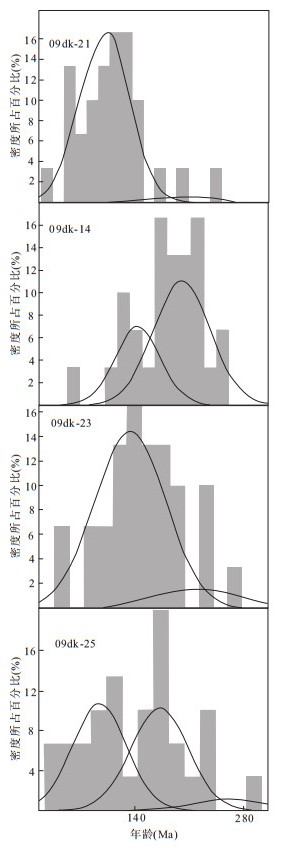
Fourteen samples were collected from the Kuqa River section for apatite fission track analysis in order to investigate the thermal history of the Kuqa Basin and its sedimentary provenance. By comparing the apparent ages of samples with the related strata ages, the samples can be divided into two groups: the annealed group and the detrital group (unreset samples).The AFT ages become younger from 136 Ma to 93.7 Ma from the Tianshan Mountain to the Kuqa Basin, probably recording a basin-ward propagation of the thrust-fold belt. Samples 09dk-6, 09dk-7, 09dk-8 and 09dk-11 failed the X2 test likely due to the subsequent tectonic deformation. The youngest ages extracted from these samples probably record the latest activities of the Kuruli Syncline, Jiesidelike Anticline and the A'ge Fault at 74.4 Ma, 24.2 Ma and 50.8 Ma, respectively. The detrital samples have three peak ages at 250 Ma, 160 Ma and 100 Ma respectively. Thermal history modeling reveals four periods of denudation at 250 Ma, 160 Ma, 100 Ma and 20 Ma in the Kuqa basin and the Tianshan Mountains. The multi-stage denudation is linked to far-field effects resulted from the collision and accretion of terranes along the southern Asian continental margin.
Fourteen samples were collected from the Kuqa River section for apatite fission track analysis in order to investigate the thermal history of the Kuqa Basin and its sedimentary provenance. By comparing the apparent ages of samples with the related strata ages, the samples can be divided into two groups: the annealed group and the detrital group (unreset samples).The AFT ages become younger from 136 Ma to 93.7 Ma from the Tianshan Mountain to the Kuqa Basin, probably recording a basin-ward propagation of the thrust-fold belt. Samples 09dk-6, 09dk-7, 09dk-8 and 09dk-11 failed the X2 test likely due to the subsequent tectonic deformation. The youngest ages extracted from these samples probably record the latest activities of the Kuruli Syncline, Jiesidelike Anticline and the A'ge Fault at 74.4 Ma, 24.2 Ma and 50.8 Ma, respectively. The detrital samples have three peak ages at 250 Ma, 160 Ma and 100 Ma respectively. Thermal history modeling reveals four periods of denudation at 250 Ma, 160 Ma, 100 Ma and 20 Ma in the Kuqa basin and the Tianshan Mountains. The multi-stage denudation is linked to far-field effects resulted from the collision and accretion of terranes along the southern Asian continental margin.


2012, 37(5): 903-916.
doi: 10.3799/dqkx.2012.099
Abstract:
The exhumation of ore-bearing rocks after mineralization plays an important role in the ore preservation, and their relation is one of major issues of mineral deposit geology. The number percentage and area proportion of intermediate-acid intrusive bodies are regarded as two indexes of mountain exhumation degree in this paper. The temperature-space distribution of current outcropped deposits in Tianshan range not only is helpful for understanding the relationship between the mountain exhumation with the preservation of early-formed deposits, but also facilitates further ore-prospecting. Statistics results show that there are very few number and little area proportion of intermediate-acid intrusive bodies in Yilianhabigaer mountain in western segment of north Tianshan, Bogeda mountain in middle segment of north Tianshan, and southwest Tianshan, where there are only few outcropped metal ore deposits mainly characterized by epithermal mineralization. And relative deeply intrusive rocks, as well as lots of large to super-large intrusive-rock-related meso-hypothermal ore deposits, are widely exposed in Jueluotage area in southern part of north Tianshan, middle Tianshan unit, and Kuluketage area in eastern segment of south Tianshan. Previous data from fission track dating of apatite shows that Yilianhabigaer mountain, Bogeda mountain, and southwest Tianshan initially uplifted at the end of the Mesozoic, followed by rapid uplift and deformation since about ca.25 Ma. Mountains in middle Tianshan, southern part of north Tianshan, and eastern segment of south Tianshan begun to uplift rapidly and denudate since the Early Jurassic, but only weak uplift occurred in the Cenozoic. The outcropped rocks, the distribution characteristics of metal ore deposits, and the uplift-exhumation process of mountains suggest that superficial volcano-sedimentary rocks are still preserved in Yilianhabigaer mountain, Bogeda mountain, and southwest Tianshan, because of shallow erosion as response to short-time sustained denudation and rapid uplift during the late Cenozoic, leading to exposure of few intermediate-acid intrusive bodies and mostly epithermal metal deposits at the surface. While those superficial volcano-sedimentary rocks in middle Tianshan, southern part of north Tianshan, and eastern segment of south Tianshan probably have already been denudated away due to long-time erosion since the Middle Mesozoic and weak deformation in the Cenozoic, and deeply intrusive rocks and meso-hypothermal ore deposits widely outcropped at the surface as a result. As to the ore-prospecting in distinct units of Tianshan range, it is suggested that various types of deposits with different ore-forming temperature should be focused on at the surface and there is favorable mineralization potential in southwest Tianshan. It also shows that the exhumation diversity of mountain is one of the most important reasons for the popular saying that "large deposits are limited within the national boundary".
The exhumation of ore-bearing rocks after mineralization plays an important role in the ore preservation, and their relation is one of major issues of mineral deposit geology. The number percentage and area proportion of intermediate-acid intrusive bodies are regarded as two indexes of mountain exhumation degree in this paper. The temperature-space distribution of current outcropped deposits in Tianshan range not only is helpful for understanding the relationship between the mountain exhumation with the preservation of early-formed deposits, but also facilitates further ore-prospecting. Statistics results show that there are very few number and little area proportion of intermediate-acid intrusive bodies in Yilianhabigaer mountain in western segment of north Tianshan, Bogeda mountain in middle segment of north Tianshan, and southwest Tianshan, where there are only few outcropped metal ore deposits mainly characterized by epithermal mineralization. And relative deeply intrusive rocks, as well as lots of large to super-large intrusive-rock-related meso-hypothermal ore deposits, are widely exposed in Jueluotage area in southern part of north Tianshan, middle Tianshan unit, and Kuluketage area in eastern segment of south Tianshan. Previous data from fission track dating of apatite shows that Yilianhabigaer mountain, Bogeda mountain, and southwest Tianshan initially uplifted at the end of the Mesozoic, followed by rapid uplift and deformation since about ca.25 Ma. Mountains in middle Tianshan, southern part of north Tianshan, and eastern segment of south Tianshan begun to uplift rapidly and denudate since the Early Jurassic, but only weak uplift occurred in the Cenozoic. The outcropped rocks, the distribution characteristics of metal ore deposits, and the uplift-exhumation process of mountains suggest that superficial volcano-sedimentary rocks are still preserved in Yilianhabigaer mountain, Bogeda mountain, and southwest Tianshan, because of shallow erosion as response to short-time sustained denudation and rapid uplift during the late Cenozoic, leading to exposure of few intermediate-acid intrusive bodies and mostly epithermal metal deposits at the surface. While those superficial volcano-sedimentary rocks in middle Tianshan, southern part of north Tianshan, and eastern segment of south Tianshan probably have already been denudated away due to long-time erosion since the Middle Mesozoic and weak deformation in the Cenozoic, and deeply intrusive rocks and meso-hypothermal ore deposits widely outcropped at the surface as a result. As to the ore-prospecting in distinct units of Tianshan range, it is suggested that various types of deposits with different ore-forming temperature should be focused on at the surface and there is favorable mineralization potential in southwest Tianshan. It also shows that the exhumation diversity of mountain is one of the most important reasons for the popular saying that "large deposits are limited within the national boundary".


2012, 37(5): 917-928.
doi: 10.3799/dqkx.2012.100
Abstract:
The early Paleozoic ophiolite section of Qiashikansayi hollow is located at the segment of Hongliuguo-Lapeiquan ophiolite belt in the North Altyn Tagh Mountains, striking from south to north. The volcanics from the south entrance of the hollow consist of meta-basalts and meta-rhyolites, with typical "double peaks". The geochemistry data show that meta-basalts derived from enriched mantle have suffered from contamination of crust, and were formed in a continental rift setting; Meta- rhyolites are similar to the A-type granite in the composition, resulted from the partial melt of lower crust due to the underplating of mantle-derived magma. Zircon LA-ICP-MS dating of rhyolite yields a U-Pb age of 749.8±4.6 Ma, representing the time of crystallization of the bimodal volcanics, and providing time evidence for the initial breakup of North Altyn Ocean together with the published regional geological reports. There are similar time of initial breakup between North Altyn Ocean and North Qilian Ocean. We suggest that this volcanic action is closely related with the breakup of Rodinia supercontinent.
The early Paleozoic ophiolite section of Qiashikansayi hollow is located at the segment of Hongliuguo-Lapeiquan ophiolite belt in the North Altyn Tagh Mountains, striking from south to north. The volcanics from the south entrance of the hollow consist of meta-basalts and meta-rhyolites, with typical "double peaks". The geochemistry data show that meta-basalts derived from enriched mantle have suffered from contamination of crust, and were formed in a continental rift setting; Meta- rhyolites are similar to the A-type granite in the composition, resulted from the partial melt of lower crust due to the underplating of mantle-derived magma. Zircon LA-ICP-MS dating of rhyolite yields a U-Pb age of 749.8±4.6 Ma, representing the time of crystallization of the bimodal volcanics, and providing time evidence for the initial breakup of North Altyn Ocean together with the published regional geological reports. There are similar time of initial breakup between North Altyn Ocean and North Qilian Ocean. We suggest that this volcanic action is closely related with the breakup of Rodinia supercontinent.


2012, 37(5): 929-936.
doi: 10.3799/dqkx.2012.101
Abstract:
This paper reports whole-rock geochemical compositions and zircon dating results of late Paleoproterozoic crustally-derived carbonatite in the northern Altyn Tagh. The carbonatite cuts contry rocks and occurs as stocks or dikes and contains different types of contry rocks. It is mainly composed of calcite, diopside, and a few silicate minerals (such as, feldspar, quartz, etc.). Samples of the carbonatite are characterized with high CaO contents (20.56%-39.80%), a large range of SiO2 contents (23.33%-54.06%), low TREE (28.36×10⁻⁶-63.01×10⁻⁶), weakly negative Eu anomalies (Eu/Eu*=0.69-0.83), moderately fractionated REE patterns ((La/Yb)n=9.20-16.85). Compared with Sr, Rb, Ba, Th (LILE), the high field strength elements (HFSE), especially Nb, Ti and P, are strongly depleted. Zircons of the carbonatite show core-rim textures, and commonly show weakly zoning. SHRIMP U-Pb zircon dating result of the carbonatites is 1 931±18 Ma. All these threw lights on that the carbonatite are formed by the anatexis of impure marbles from Milan group.
This paper reports whole-rock geochemical compositions and zircon dating results of late Paleoproterozoic crustally-derived carbonatite in the northern Altyn Tagh. The carbonatite cuts contry rocks and occurs as stocks or dikes and contains different types of contry rocks. It is mainly composed of calcite, diopside, and a few silicate minerals (such as, feldspar, quartz, etc.). Samples of the carbonatite are characterized with high CaO contents (20.56%-39.80%), a large range of SiO2 contents (23.33%-54.06%), low TREE (28.36×10⁻⁶-63.01×10⁻⁶), weakly negative Eu anomalies (Eu/Eu*=0.69-0.83), moderately fractionated REE patterns ((La/Yb)n=9.20-16.85). Compared with Sr, Rb, Ba, Th (LILE), the high field strength elements (HFSE), especially Nb, Ti and P, are strongly depleted. Zircons of the carbonatite show core-rim textures, and commonly show weakly zoning. SHRIMP U-Pb zircon dating result of the carbonatites is 1 931±18 Ma. All these threw lights on that the carbonatite are formed by the anatexis of impure marbles from Milan group.


2012, 37(5): 937-946.
doi: 10.3799/dqkx.2012.102
Abstract:
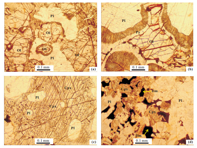
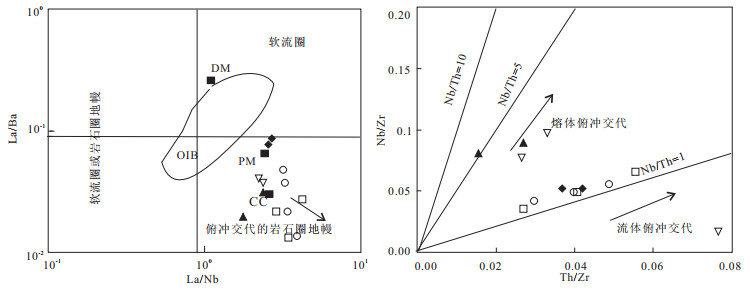
Halaqiaola mafic intrusion lies in the southeast margin of the Altai orogenic belt in Xinjiang, northwestern China. The main rock types are gabbros, gabbro norite, plagioclase-bearing pyroxenite, olivine gabbro and troctolite. Halaqiaola intrusion has low contents of TiO2 (0.09%-1.28%) and alkali (Na2O+K2O=0.37%-0.78%), and belongs to tholeiitic series; the intrusion is rich in large ion lithophile elements and light rare earth elements and depleted in high field elements (such as Nb, Ta). The εNd(t) and the εSr(t) values range from -2.62 to -0.78 and 37.49 to 45.28 respectively. Element geochemistry and Nd-Sr isotopic composition shows that the magma was derived from the dehydration of subducted plate and metasomatismed enriched lithosphere mantle. The primary magma of the intrusion is basaltic magma. During the process of magma evolution, the primary magma has experienced fractional crystallization of olivine, clinopyroxene and plagioclase, with ilmenite-precipitation in the late period.
Halaqiaola mafic intrusion lies in the southeast margin of the Altai orogenic belt in Xinjiang, northwestern China. The main rock types are gabbros, gabbro norite, plagioclase-bearing pyroxenite, olivine gabbro and troctolite. Halaqiaola intrusion has low contents of TiO2 (0.09%-1.28%) and alkali (Na2O+K2O=0.37%-0.78%), and belongs to tholeiitic series; the intrusion is rich in large ion lithophile elements and light rare earth elements and depleted in high field elements (such as Nb, Ta). The εNd(t) and the εSr(t) values range from -2.62 to -0.78 and 37.49 to 45.28 respectively. Element geochemistry and Nd-Sr isotopic composition shows that the magma was derived from the dehydration of subducted plate and metasomatismed enriched lithosphere mantle. The primary magma of the intrusion is basaltic magma. During the process of magma evolution, the primary magma has experienced fractional crystallization of olivine, clinopyroxene and plagioclase, with ilmenite-precipitation in the late period.


2012, 37(5): 947-954.
doi: 10.3799/dqkx.2012.103
Abstract:
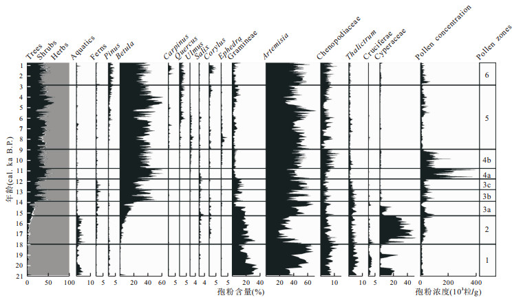
Moon Lake is one of the volcanic crater lakes at the Aershan-Chaihe volcanic field in the middle part of Daxing'an Mountain Range, located at the current northern margin of the East Asian monsoon. Pollen records of 8.86 m-long sediment core of Moon Lake reveal the vegetation evolution and climate change since the Late Glacial. The result indicates predominantly steppe communities, which are typical of cold and dry climate conditions between 20.9 and 18.0 cal. ka B.P.; the meadow communities which stand for cold and damp climate conditions are present between 18.0 and 15.3 cal. ka B.P.; the beginning of expansion of arbor marks the vegetation change from meadow to forest steppe and the onset of the Late Glacial climatic amelioration towards warm and humid from 15.3 to 14.0 cal. ka B.P.; the woodland expands with the shrink of steppe under the warm and humid climate from 14.0 to 12.8 cal. ka B.P., correlating with the Bølling-Allerød climate event; the steppe expands later from 12.8 to 11.8 cal. ka B.P. effected by the cold climate, correlating with the Younger Dryas climate events; forest steppe dominates study area under warm climate from 11.8 to 0.8 cal. ka B.P. with six times steppe expansion impacted by cold climate events, which occurred at 9.0-8.9, 8.2-7.8, 7.0-6.8, 6.1-5.6, 5.4-5.2, 2.3-1.8 cal. ka B.P. during the Holocene. These climate events are comparable with other global and regional high-resolution paleoclimate records, revealing the Moon Lake sensitively record the global and regional climate change and high-resolution pollen analysis of study area is a good indicator of East Asian monsoon strength change.
Moon Lake is one of the volcanic crater lakes at the Aershan-Chaihe volcanic field in the middle part of Daxing'an Mountain Range, located at the current northern margin of the East Asian monsoon. Pollen records of 8.86 m-long sediment core of Moon Lake reveal the vegetation evolution and climate change since the Late Glacial. The result indicates predominantly steppe communities, which are typical of cold and dry climate conditions between 20.9 and 18.0 cal. ka B.P.; the meadow communities which stand for cold and damp climate conditions are present between 18.0 and 15.3 cal. ka B.P.; the beginning of expansion of arbor marks the vegetation change from meadow to forest steppe and the onset of the Late Glacial climatic amelioration towards warm and humid from 15.3 to 14.0 cal. ka B.P.; the woodland expands with the shrink of steppe under the warm and humid climate from 14.0 to 12.8 cal. ka B.P., correlating with the Bølling-Allerød climate event; the steppe expands later from 12.8 to 11.8 cal. ka B.P. effected by the cold climate, correlating with the Younger Dryas climate events; forest steppe dominates study area under warm climate from 11.8 to 0.8 cal. ka B.P. with six times steppe expansion impacted by cold climate events, which occurred at 9.0-8.9, 8.2-7.8, 7.0-6.8, 6.1-5.6, 5.4-5.2, 2.3-1.8 cal. ka B.P. during the Holocene. These climate events are comparable with other global and regional high-resolution paleoclimate records, revealing the Moon Lake sensitively record the global and regional climate change and high-resolution pollen analysis of study area is a good indicator of East Asian monsoon strength change.

2012, 37(5): 955-965.
doi: 10.3799/dqkx.2012.104
Abstract:
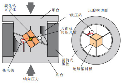
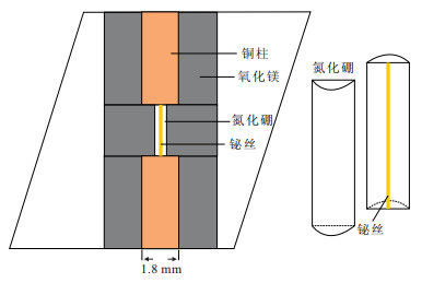
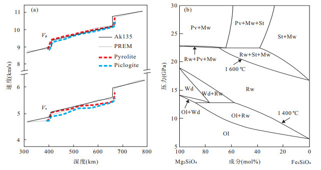
High temperature and high pressure (HTHP) experiments is an important approach to study the nature of earth's deep interior. Multi-anvil press is widely used investigating phase transitions and mineral physics under the upper mantle conditions. The pressure calibration of the 18/12 (Octahedron Edge length/Truncated Edge Length) sample assembly for the multi-anvil press installed in China university of geosciences are summarized in this paper. Pressures for the 18/12 assembly were calibrated using phase transitions in bismuth at 2.55 GPa (Ⅰ-Ⅱ), and 7.7 GPa (Ⅲ-Ⅴ) at room temperature, and using quartz /coesite phase transition at 3.2 GPa and 1 200 ℃. This assembly can cover a pressure and temperature range up to 8 GPa and 2 000 ℃. Finally, the applications of HT-HP experiment in geosciences are also briefly discussed.
High temperature and high pressure (HTHP) experiments is an important approach to study the nature of earth's deep interior. Multi-anvil press is widely used investigating phase transitions and mineral physics under the upper mantle conditions. The pressure calibration of the 18/12 (Octahedron Edge length/Truncated Edge Length) sample assembly for the multi-anvil press installed in China university of geosciences are summarized in this paper. Pressures for the 18/12 assembly were calibrated using phase transitions in bismuth at 2.55 GPa (Ⅰ-Ⅱ), and 7.7 GPa (Ⅲ-Ⅴ) at room temperature, and using quartz /coesite phase transition at 3.2 GPa and 1 200 ℃. This assembly can cover a pressure and temperature range up to 8 GPa and 2 000 ℃. Finally, the applications of HT-HP experiment in geosciences are also briefly discussed.


2012, 37(5): 966-980.
doi: 10.3799/dqkx.2012.105
Abstract:
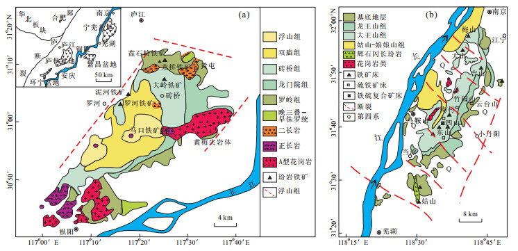
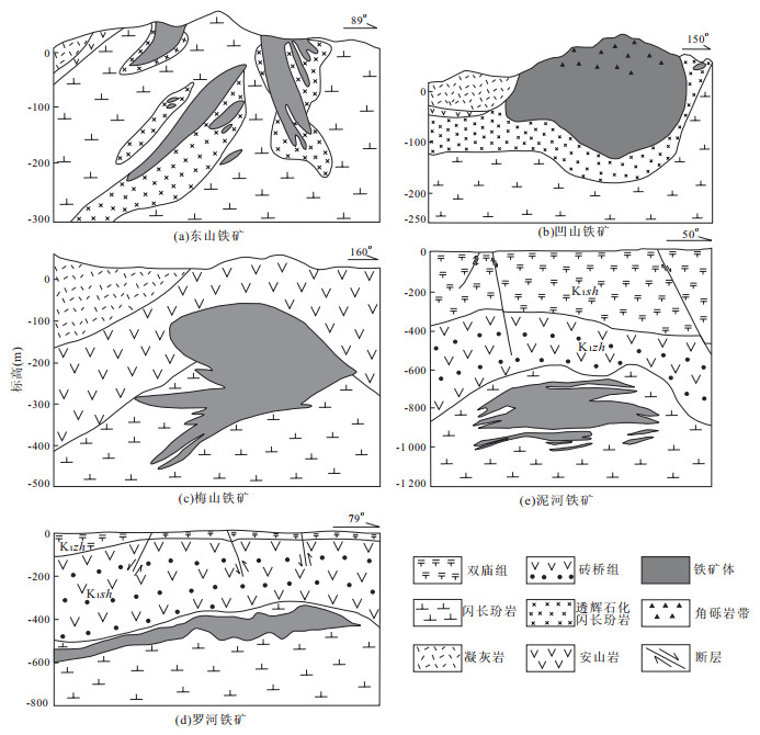
The metallogenic depth and post-mineralization uplift and denudation are the key issues in deep prospecting, which have been weak in the study of mineral deposits due to the absence of effective technology. The authors select Dongshan, Meishan porphyry-like iron deposits in Ningwu basin and Nihe, Luohe porphyry-like iron deposits in Luzong basin formed about ~130 Ma as the study subjects for the metallogenic depth and post-mineralization uplift and denudation of porphyry-like iron deposits, with the help of AFT analysis of apatites in ore mineral assemblages. The results suggest: (1) the pooled AFT ages(1σ) of the four deposits are 106.3±5.4 Ma, 94.2±4.0 Ma, 81.3±4.0 Ma and 79.1±3.3 Ma, respectively, showing the ore bodies of four deposits passed the PAZ successively. The AFT ages and confined track lengths decrease with the increase of buried depth of samples and become close to the mineralization ages and the initial confined track length, which are possibly controlled by diverse uplift and denudation after mineralization leading to the different cooling rates while the samples passed the PAZ. (2) The thermal histories of AFT modeling reflect that there are two different cooling stages, namely the rapid cooling progress caused by losing of heat source and the slow cooling progress caused by uplift. The temperature inflection points between the two stages of the four deposits are probably identical, corresponding to a depth of 1.7 to 1.8 km. (3) Since 110 Ma, the uplift and denudation rate of the Ningwu basin have been greater than those of Luzong basin, so that most ore deposits in Ningwu basin buried shallowly or even exposed to the surface. The early uplift and denudation were controlled by the regional Yellow Bridge tectonic event.
The metallogenic depth and post-mineralization uplift and denudation are the key issues in deep prospecting, which have been weak in the study of mineral deposits due to the absence of effective technology. The authors select Dongshan, Meishan porphyry-like iron deposits in Ningwu basin and Nihe, Luohe porphyry-like iron deposits in Luzong basin formed about ~130 Ma as the study subjects for the metallogenic depth and post-mineralization uplift and denudation of porphyry-like iron deposits, with the help of AFT analysis of apatites in ore mineral assemblages. The results suggest: (1) the pooled AFT ages(1σ) of the four deposits are 106.3±5.4 Ma, 94.2±4.0 Ma, 81.3±4.0 Ma and 79.1±3.3 Ma, respectively, showing the ore bodies of four deposits passed the PAZ successively. The AFT ages and confined track lengths decrease with the increase of buried depth of samples and become close to the mineralization ages and the initial confined track length, which are possibly controlled by diverse uplift and denudation after mineralization leading to the different cooling rates while the samples passed the PAZ. (2) The thermal histories of AFT modeling reflect that there are two different cooling stages, namely the rapid cooling progress caused by losing of heat source and the slow cooling progress caused by uplift. The temperature inflection points between the two stages of the four deposits are probably identical, corresponding to a depth of 1.7 to 1.8 km. (3) Since 110 Ma, the uplift and denudation rate of the Ningwu basin have been greater than those of Luzong basin, so that most ore deposits in Ningwu basin buried shallowly or even exposed to the surface. The early uplift and denudation were controlled by the regional Yellow Bridge tectonic event.


2012, 37(5): 981-988.
doi: 10.3799/dqkx.2012.106
Abstract:
Three kinds of seal stones from China, namely, Shan PaoLv (SPL) seal stone in Qingtian, Yue WeiLv (YWL) seal stone in Shoushan and newly found Xi AnLv (XAL) seal stone have been studied by X-ray diffractometer, electronic microprobe analyses, environmental scanning electron microscope, and energy dispersive spectroscopy to obtain their mineral composition, chemical composition, micro-morphology characterization, and cause of color formation. It has been found that the green parts in these three seal stones are dio-octahedral 2M1 muscovites and they belong to mica-seal stone. As to minor mineral compositions, they are dolomite, pyrite and apatite in SPL; it is kaolinite in YWL, and it is dolomite in XAL, which can provide some information for their respective places of origin. Micro-morphology characterization of the three kinds of muscovites indicate crystallization of muscovite in XAL is better than that in YWL, and the crystal shape of muscovite in SPL is not good because it has undergone hydrothermal alteration. On the other hand, chemical analyses of impurity ions in octahedral sheet have been studied in order to discuss color causing factors of green muscovite which suggests that green color in YWL and XAL are caused by Fe3+ and Ti4+ while green color in SPL is caused by Cr3+ in company with Fe3+ and Ti4+.
Three kinds of seal stones from China, namely, Shan PaoLv (SPL) seal stone in Qingtian, Yue WeiLv (YWL) seal stone in Shoushan and newly found Xi AnLv (XAL) seal stone have been studied by X-ray diffractometer, electronic microprobe analyses, environmental scanning electron microscope, and energy dispersive spectroscopy to obtain their mineral composition, chemical composition, micro-morphology characterization, and cause of color formation. It has been found that the green parts in these three seal stones are dio-octahedral 2M1 muscovites and they belong to mica-seal stone. As to minor mineral compositions, they are dolomite, pyrite and apatite in SPL; it is kaolinite in YWL, and it is dolomite in XAL, which can provide some information for their respective places of origin. Micro-morphology characterization of the three kinds of muscovites indicate crystallization of muscovite in XAL is better than that in YWL, and the crystal shape of muscovite in SPL is not good because it has undergone hydrothermal alteration. On the other hand, chemical analyses of impurity ions in octahedral sheet have been studied in order to discuss color causing factors of green muscovite which suggests that green color in YWL and XAL are caused by Fe3+ and Ti4+ while green color in SPL is caused by Cr3+ in company with Fe3+ and Ti4+.


2012, 37(5): 989-1002.
doi: 10.3799/dqkx.2012.107
Abstract:
Located in the western Qinling orogen, the Qiuling gold deposit is a typical Carlin-type gold deposit. Gold mineralization is hosted in calcareous siltstones, silty shales, and argillaceous limestones of the Upper Devonian Nanyangshan Formation and the Lower Carboniferous Yuanjiagou Formation. Pyrite and arsenopyrite dominate the metallic minerals, whereas quartz, calcite, and sericite are the main non-metallic alteration minerals. An integration of optical microscopy, scanning electron microscopy equipped with energy dispersive system, electron microprobe, and laser ablation ICP-MS was used to study the occurrence, distribution, and enrichment mechanism of gold in the Qiuling gold deposit. The results indicate that gold occurs as submicroscopic and, less significantly, microscopic species. The submicroscopic gold is present as nanoparticles of native gold (Au0) in the coarse-grained pyrite and solid solution (Au+) in the arsenian rims of zoned pyrite and arsenopyrite, with lesser amount of gold nanoparticles in the As-deficient core of zoned pyrite. The sub-microscopic gold particles in the core of zoned pyrite were likely formed during the diagenesis of the host rocks through adsorption, while the structure-bounded Au (Au0 and Au+) in fine-grained zoned pyrite and arsenopyrite may have been transported as sulfur and arsenic complexes in ore-forming fluids of the main hydrothermal stage. Microscopic gold grains are mostly less than 3 to 5 μm in size and are contained in the marginal areas fine-grained pyrite and included in hydrothermal sericite, quartz, and calcite. They formed likely due to local saturation of gold in the ore fluids or as a result of leaching of the submicroscopic gold by late-stage fluids and subsequent re-precipitation.
Located in the western Qinling orogen, the Qiuling gold deposit is a typical Carlin-type gold deposit. Gold mineralization is hosted in calcareous siltstones, silty shales, and argillaceous limestones of the Upper Devonian Nanyangshan Formation and the Lower Carboniferous Yuanjiagou Formation. Pyrite and arsenopyrite dominate the metallic minerals, whereas quartz, calcite, and sericite are the main non-metallic alteration minerals. An integration of optical microscopy, scanning electron microscopy equipped with energy dispersive system, electron microprobe, and laser ablation ICP-MS was used to study the occurrence, distribution, and enrichment mechanism of gold in the Qiuling gold deposit. The results indicate that gold occurs as submicroscopic and, less significantly, microscopic species. The submicroscopic gold is present as nanoparticles of native gold (Au0) in the coarse-grained pyrite and solid solution (Au+) in the arsenian rims of zoned pyrite and arsenopyrite, with lesser amount of gold nanoparticles in the As-deficient core of zoned pyrite. The sub-microscopic gold particles in the core of zoned pyrite were likely formed during the diagenesis of the host rocks through adsorption, while the structure-bounded Au (Au0 and Au+) in fine-grained zoned pyrite and arsenopyrite may have been transported as sulfur and arsenic complexes in ore-forming fluids of the main hydrothermal stage. Microscopic gold grains are mostly less than 3 to 5 μm in size and are contained in the marginal areas fine-grained pyrite and included in hydrothermal sericite, quartz, and calcite. They formed likely due to local saturation of gold in the ore fluids or as a result of leaching of the submicroscopic gold by late-stage fluids and subsequent re-precipitation.


2012, 37(5): 1003-1014.
doi: 10.3799/dqkx.2012.108
Abstract:
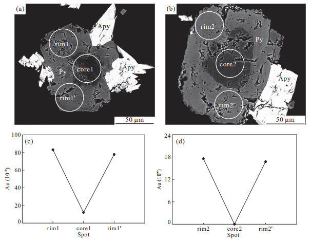
Zhaxikang antimony polymetallic ore deposit, the first super large deposit discovered in northern Himalayan metallogenic belt (NHMB) and first SEDEX discovered modified by hot spring type Mn-Fe-Sb-Pb-Zn-Ag deposit in China, is the marked prospecting breakthrough in the youngest and great southern Tibetan detachment system (STDS). Many detailed field surveys and comprehensive researches have been made to seek evidence of SEDEX and hot spring mineralization, including the ferromanganese carbonate formation, lamellar structure, dalmatianite structure, concentric rings, paleo-spout, hot water eggs, hydrothermal breccia, hot spring hole, (Pb+Zn) concentration much higher than Cu, Ga concentration much higher than In, as well as the higher concentrations of Mn, Fe, Ba and B. These indicate that Zhaxikang is the SEDEX modified by hot spring type deposit. The innovation of ore-forming prospecting theory method plays an important role in the prospecting breakthrough of Zhaxikang deposit. Based on the analysis of characteristics of ore deposit and its genetic type, the discovery process and exploration advance were introduced, which is of great significance both in the prospecting theories and practices, and in the exploration and evaluation, scientific research, and theory innovation in NHMB.
Zhaxikang antimony polymetallic ore deposit, the first super large deposit discovered in northern Himalayan metallogenic belt (NHMB) and first SEDEX discovered modified by hot spring type Mn-Fe-Sb-Pb-Zn-Ag deposit in China, is the marked prospecting breakthrough in the youngest and great southern Tibetan detachment system (STDS). Many detailed field surveys and comprehensive researches have been made to seek evidence of SEDEX and hot spring mineralization, including the ferromanganese carbonate formation, lamellar structure, dalmatianite structure, concentric rings, paleo-spout, hot water eggs, hydrothermal breccia, hot spring hole, (Pb+Zn) concentration much higher than Cu, Ga concentration much higher than In, as well as the higher concentrations of Mn, Fe, Ba and B. These indicate that Zhaxikang is the SEDEX modified by hot spring type deposit. The innovation of ore-forming prospecting theory method plays an important role in the prospecting breakthrough of Zhaxikang deposit. Based on the analysis of characteristics of ore deposit and its genetic type, the discovery process and exploration advance were introduced, which is of great significance both in the prospecting theories and practices, and in the exploration and evaluation, scientific research, and theory innovation in NHMB.


2012, 37(5): 1015-1028.
doi: 10.3799/dqkx.2012.109
Abstract:
Located in Mesozoic strata of northern Lanping basin, Northwest of Yunnan Province, Baiyangping deposit is a sediment-hosted Pb-Zn-Cu-Ag polymetallic deposit controlled by fracture. In this paper, a study is carried out on the fluid inclusions in ore-forming stage calcite, quartz, sphalerite and C, O isotope of calcite and S, Pb isotope of sulfur-bearing minerals, on basis of which the character and source of ore-forming fluids and the source of ore-forming materials are discussed. The fluid inclusions of Baiyangping deposit are generally less than 10 μm, main gas-liquid phase. The ore-forming fluid system was Ca2+-Na+-K+-Mg2+-Cl--F--NO3- brine system. The freezing temperature of fluid inclusions in mineral deposits ranges from -26.4 to -0.2 ℃, with an average of -14.6 ℃; the homogenization temperature is concentrated in 120-180 ℃, and the salinity varies from 0.35% to 24.73% (NaCleq), with an average of 16.9% (NaCleq). ore-forming fluid density is between 0.84 g/cm3 and 1.11 g/cm3, with an average of 1.04 g/cm3, mineralization pressure is between 28.0 MPa and 46.9 MPa, with an average of 37.6 MPa; the corresponding mineralization depths is between 1 058 m and 2 452 m, with an average of 1 555 m, concentrated in 1 200 m to 1 800 m; Carbon and oxygen isotope data indicate a homogeneous carbon source, and the carbon in hydrothermal calcite is derived from the dissolution of carbonate rock strata. The ore-forming fluid belongs to the basin brine fluid system, which is mixed with the precipitate water; S isotope data show that sulfur in sulfides and sulphosalts is derived from thermochemical sulfate reduction, or the thermal decomposition of sulfur-bearing organic matter; the metal mineralization material is from sedimentary strata and basement.
Located in Mesozoic strata of northern Lanping basin, Northwest of Yunnan Province, Baiyangping deposit is a sediment-hosted Pb-Zn-Cu-Ag polymetallic deposit controlled by fracture. In this paper, a study is carried out on the fluid inclusions in ore-forming stage calcite, quartz, sphalerite and C, O isotope of calcite and S, Pb isotope of sulfur-bearing minerals, on basis of which the character and source of ore-forming fluids and the source of ore-forming materials are discussed. The fluid inclusions of Baiyangping deposit are generally less than 10 μm, main gas-liquid phase. The ore-forming fluid system was Ca2+-Na+-K+-Mg2+-Cl--F--NO3- brine system. The freezing temperature of fluid inclusions in mineral deposits ranges from -26.4 to -0.2 ℃, with an average of -14.6 ℃; the homogenization temperature is concentrated in 120-180 ℃, and the salinity varies from 0.35% to 24.73% (NaCleq), with an average of 16.9% (NaCleq). ore-forming fluid density is between 0.84 g/cm3 and 1.11 g/cm3, with an average of 1.04 g/cm3, mineralization pressure is between 28.0 MPa and 46.9 MPa, with an average of 37.6 MPa; the corresponding mineralization depths is between 1 058 m and 2 452 m, with an average of 1 555 m, concentrated in 1 200 m to 1 800 m; Carbon and oxygen isotope data indicate a homogeneous carbon source, and the carbon in hydrothermal calcite is derived from the dissolution of carbonate rock strata. The ore-forming fluid belongs to the basin brine fluid system, which is mixed with the precipitate water; S isotope data show that sulfur in sulfides and sulphosalts is derived from thermochemical sulfate reduction, or the thermal decomposition of sulfur-bearing organic matter; the metal mineralization material is from sedimentary strata and basement.


2012, 37(5): 1029-1042.
doi: 10.3799/dqkx.2012.110
Abstract:
Dongying depression is a typical overpressured depression with abundant petroleum resources, and the present-day large-scale overpressured system occurs in the Eocene third and fourth members of the Shahejie Formation (Es3-Es4) in the depression as evidenced by drill stem test (DST) data, and the source rocks also exist within the overpressured system. Based on a large number of drill stem test (DST) data, the burial depths of overpressured sandstone reservoirs range from 2 200 to 4 400 m with excess pressures of about 4 to 40 MPa and pressure coefficients of 1.2 to 1.99. According to the integrated interpretation of drilling, well logging and seismic velocity data, the large-scale overpressured system is associated with significant increase in drilling mud density, as well as abnormal high sonic transit times with deviation from the normal trend and low seismic interval velocity responding. On the whole, the burial depths of the top overpressured surface range from 2 200 to 2 900 m with corresponding formation temperatures ranging from 90 to 120 ℃, and the depths of top overpressure surface increase as the burial depths of source rocks deepen. Many evidences suggest that the oil generation from the source rocks is the major cause of the present-day large-scale overpressured system in the Es3-Es4 of Dongying depression. This study indicates that the large-scale overpressured system is well developed where the cumulative thickness of mature source rocks is thick and source rocks remain in oil-generating stage of thermal evolution with vitrinite reflectance values varying from 0.5% to 1.2% of overpressured source rocks, and the fault system and sandstone transporting layers have great influence on the distribution and construction change of the large-scale overpressured system in the Es3-Es4 of Dongying depression.
Dongying depression is a typical overpressured depression with abundant petroleum resources, and the present-day large-scale overpressured system occurs in the Eocene third and fourth members of the Shahejie Formation (Es3-Es4) in the depression as evidenced by drill stem test (DST) data, and the source rocks also exist within the overpressured system. Based on a large number of drill stem test (DST) data, the burial depths of overpressured sandstone reservoirs range from 2 200 to 4 400 m with excess pressures of about 4 to 40 MPa and pressure coefficients of 1.2 to 1.99. According to the integrated interpretation of drilling, well logging and seismic velocity data, the large-scale overpressured system is associated with significant increase in drilling mud density, as well as abnormal high sonic transit times with deviation from the normal trend and low seismic interval velocity responding. On the whole, the burial depths of the top overpressured surface range from 2 200 to 2 900 m with corresponding formation temperatures ranging from 90 to 120 ℃, and the depths of top overpressure surface increase as the burial depths of source rocks deepen. Many evidences suggest that the oil generation from the source rocks is the major cause of the present-day large-scale overpressured system in the Es3-Es4 of Dongying depression. This study indicates that the large-scale overpressured system is well developed where the cumulative thickness of mature source rocks is thick and source rocks remain in oil-generating stage of thermal evolution with vitrinite reflectance values varying from 0.5% to 1.2% of overpressured source rocks, and the fault system and sandstone transporting layers have great influence on the distribution and construction change of the large-scale overpressured system in the Es3-Es4 of Dongying depression.


2012, 37(5): 1043-1050.
doi: 10.3799/dqkx.2012.111
Abstract:
In order to reveal the main control factors of natural gas adsorption capacity of clay minerals, the methane adsorption isotherm experiments of common clay minerals selected from different sources were performed. The analysis shows that differences of gas adsorption capacity are significant among different types of clay minerals, and the order of methane adsorption capacity of various clay minerals is smectite >> illite and smectite mixed-layers > kaolinite > chlorite > illite > siltstone > quartzite. The crystal structure of clay mineral determines the shape and size of pore spaces between polymer particles and interlayer spaces between crystal layers, and accordingly determines its surface area and gas adsorption capability. Methane adsorption capacities of clay minerals are highly consistent to the development degrees of micro-pores supplied by scanning electron microscopy. The study indicates that the gas adsorption capacity of clay minerals not only depends on the type of clay mineral, but also is significantly influenced by diagenesis and petrogenesis. In addition, the gas adsorption capacity of clay minerals slightly increases with the decrease of particle size due to the enlargement of pore connectivity and surface area.
In order to reveal the main control factors of natural gas adsorption capacity of clay minerals, the methane adsorption isotherm experiments of common clay minerals selected from different sources were performed. The analysis shows that differences of gas adsorption capacity are significant among different types of clay minerals, and the order of methane adsorption capacity of various clay minerals is smectite >> illite and smectite mixed-layers > kaolinite > chlorite > illite > siltstone > quartzite. The crystal structure of clay mineral determines the shape and size of pore spaces between polymer particles and interlayer spaces between crystal layers, and accordingly determines its surface area and gas adsorption capability. Methane adsorption capacities of clay minerals are highly consistent to the development degrees of micro-pores supplied by scanning electron microscopy. The study indicates that the gas adsorption capacity of clay minerals not only depends on the type of clay mineral, but also is significantly influenced by diagenesis and petrogenesis. In addition, the gas adsorption capacity of clay minerals slightly increases with the decrease of particle size due to the enlargement of pore connectivity and surface area.


2012, 37(5): 1051-1065.
doi: 10.3799/dqkx.2012.112
Abstract:
Carboniferous Karashayi Formation of Tarim basin formed in the continental shelf environment, is composed of several sedimentary assemblages of clastic rocks, carbonate rocks and gypsum rocks. It is one of the important reservoir combination in the Tarim basin. According to the research results of paleontology, the formation can be approximately correlated with the Visean and Serpukhovian Stage of the International Stratigraphic Chart, about ±27 Ma. Currently, the research of sequence stratigraphy on Karashayi Formation is relatively weak. Due to lack of obvious discontinuity surfaces, a limited number of studies have been divided the formation into 3-4 third-order sequences, which leads to a conflict as to the time limits ±27 Ma. In this paper, the cyclostratigraphy was carried on well logs GR (Natural Gamma-Ray Log), SP (Spontaneous Potential Log), U, Th, K, etc. of Karashayi Formation with spectral analysis and wavelet analysis methods. Integrated with core observation and sedimentary base level study, 9-11 third-order sequences were identified in Karashayi Formation of Well Mai6, Zhong1, Zhong17 and Shun6. The average time duration of each cycle is about 2.40 Ma. This value corresponds to the intersection astronomical period of the three Earth orbital parameters. Not only do the results reflect the application value of the method, but also reflect that the climatic cycles are the controlling factors on the development of third-order sequences.
Carboniferous Karashayi Formation of Tarim basin formed in the continental shelf environment, is composed of several sedimentary assemblages of clastic rocks, carbonate rocks and gypsum rocks. It is one of the important reservoir combination in the Tarim basin. According to the research results of paleontology, the formation can be approximately correlated with the Visean and Serpukhovian Stage of the International Stratigraphic Chart, about ±27 Ma. Currently, the research of sequence stratigraphy on Karashayi Formation is relatively weak. Due to lack of obvious discontinuity surfaces, a limited number of studies have been divided the formation into 3-4 third-order sequences, which leads to a conflict as to the time limits ±27 Ma. In this paper, the cyclostratigraphy was carried on well logs GR (Natural Gamma-Ray Log), SP (Spontaneous Potential Log), U, Th, K, etc. of Karashayi Formation with spectral analysis and wavelet analysis methods. Integrated with core observation and sedimentary base level study, 9-11 third-order sequences were identified in Karashayi Formation of Well Mai6, Zhong1, Zhong17 and Shun6. The average time duration of each cycle is about 2.40 Ma. This value corresponds to the intersection astronomical period of the three Earth orbital parameters. Not only do the results reflect the application value of the method, but also reflect that the climatic cycles are the controlling factors on the development of third-order sequences.


2012, 37(5): 1067-1074.
doi: 10.3799/dqkx.2012.113
Abstract:
The impoundments of Three Gorge Reservoir have obviously intensified the reservoir bank landslide deformation since 2003. Landslide deformation can cause not only damages, but also evokes great surge once high-speed landslide sliding into reservoir, which is a potential hazard far worse than landslide itself. Owing to the reservoir impoundment, Qianjiangping landslide in Three Gorges Reservoir Area (TGRA) occurred on July 13, 2003. The highest height of landslide-induced surge reached 39 meters which resulted in wave spreading more than 30 kilometers far away along the channel, causing casualties and property losses. In order to study the characteristics and propagation law of landslide-induced surge, based on the major scientific project in TGRA, this paper presenta comprehensive researches on landslide surge hazard in TGRA through large laboratory physical model experiments. Through the statistical analysis of geological data about the potential landslides in TGRA, adopting the orthogonal experimental design method, we formulated the experiment scheme which included landslide scale, speed entering into the water, sliding plane obliquity, water depth, and slope angle. Besides, we took the channel of Baishuihe landslide in TGRA as prototype, established the river physical model in map scale 1∶200, and thus developed landslide surge three-dimensional physical model experiment by adopting the experimental control system and measurement system. According to the careful physical model experiments, we obtained reliable experimental data of landslide surge. Based on the morphological changes of landslide surge, we confirmed the concept of head wave. Then based on the classical landslide surge formulas proposed by Noda and Pan Jiazheng, by analyzing the measured data, we deduced the landslide surge calculation formulas in TGRA. At last, taking Baishuihe landslide being in deformation as an example, these formulas were used to forecast the maximum head wave height and the decay law of landslide surge along the channel.
The impoundments of Three Gorge Reservoir have obviously intensified the reservoir bank landslide deformation since 2003. Landslide deformation can cause not only damages, but also evokes great surge once high-speed landslide sliding into reservoir, which is a potential hazard far worse than landslide itself. Owing to the reservoir impoundment, Qianjiangping landslide in Three Gorges Reservoir Area (TGRA) occurred on July 13, 2003. The highest height of landslide-induced surge reached 39 meters which resulted in wave spreading more than 30 kilometers far away along the channel, causing casualties and property losses. In order to study the characteristics and propagation law of landslide-induced surge, based on the major scientific project in TGRA, this paper presenta comprehensive researches on landslide surge hazard in TGRA through large laboratory physical model experiments. Through the statistical analysis of geological data about the potential landslides in TGRA, adopting the orthogonal experimental design method, we formulated the experiment scheme which included landslide scale, speed entering into the water, sliding plane obliquity, water depth, and slope angle. Besides, we took the channel of Baishuihe landslide in TGRA as prototype, established the river physical model in map scale 1∶200, and thus developed landslide surge three-dimensional physical model experiment by adopting the experimental control system and measurement system. According to the careful physical model experiments, we obtained reliable experimental data of landslide surge. Based on the morphological changes of landslide surge, we confirmed the concept of head wave. Then based on the classical landslide surge formulas proposed by Noda and Pan Jiazheng, by analyzing the measured data, we deduced the landslide surge calculation formulas in TGRA. At last, taking Baishuihe landslide being in deformation as an example, these formulas were used to forecast the maximum head wave height and the decay law of landslide surge along the channel.


2012, 37(5): 1075-1081.
doi: 10.3799/dqkx.2012.114
Abstract:
According to the migration of water, surfactant, DNAPLs (dense nonaqueous phase liquid), and their interaction mechanism, a three-dimensional numerical simulation model was build to simulate the process of surfactant enhanced aquifer remediation at DNAPLs contaminated aquifer. The model was applied to a heterogeneous PCE-contaminated aquifer for simulating both the contamination process and remediation process. The result show that the numerical simulation model provided the mathematical description of migration and fate of NAPLs (nonaqueous phase liquids) in surfactant enhanced aquifer remediation processes, and with limited time and parameters it can depict NAPLs migration law in aquifer realistically and simulate surfactant remediation processes effectively. Moreover, the modeling results show that, it's removal efficiency is 63.5% after 40 days remediation due to the solubilization and mobilization of surfactant which is 32% higher than that of pump and treat (removal efficiency is 31.8%).
According to the migration of water, surfactant, DNAPLs (dense nonaqueous phase liquid), and their interaction mechanism, a three-dimensional numerical simulation model was build to simulate the process of surfactant enhanced aquifer remediation at DNAPLs contaminated aquifer. The model was applied to a heterogeneous PCE-contaminated aquifer for simulating both the contamination process and remediation process. The result show that the numerical simulation model provided the mathematical description of migration and fate of NAPLs (nonaqueous phase liquids) in surfactant enhanced aquifer remediation processes, and with limited time and parameters it can depict NAPLs migration law in aquifer realistically and simulate surfactant remediation processes effectively. Moreover, the modeling results show that, it's removal efficiency is 63.5% after 40 days remediation due to the solubilization and mobilization of surfactant which is 32% higher than that of pump and treat (removal efficiency is 31.8%).


2012, 37(5): 1082-1092.
doi: 10.3799/dqkx.2012.115
Abstract:
Three atmospheric/topographic corrected Landsat images (acquired form 17/03/1977, 05/02/2001, 06/02/2010) have been used to map the glacier extents using threshold ratio images (BAND4/BAND5) and ISODATA unsupervised classification, respectively. A few of manual editing was made to correct the outline at ice-lake contacts and at debris covered glaciers. Spatial-temporal distribution and changes of glaciers are analyzed based on GIS and RS. Results show that (1) The glacier in WNR covered 571.81±16.01 km2 in 2010, located mainly at the elevation zone of 5 500-6 200 m; (2) The glacier retreat is obvious in recent three decades, especially in the last decade. The glacier area had decreased by 22.42%±2.90% between 1977 and 2010. (3) Compared to the period 1977-2001, the glacier retreat rate in the last decade is higher. (4) The annual mean reduction of glacier area slows down in the elevation zone of lower 5 700 m, while it speeds up between 5 800-7 000 m. (5) In Lhasa River basin the elevation zone that the glacier reduction fastest is 100 m higher than that in the Namco basin. The Lhasa river basin glacier reduction was affected by the climate change and anthropogenic activities, while the glacier retreat in Namco basin was mainly caused by climate change. (6) The rate of glacier retreat is higher in Namco basin on the northern slope (23.6%±2.88%) of research area than those on the southern slope (21.97%±2.90%). And the elevation zone where the highest rate of glacier retreat during 2001-2010 is 200 m higher than those between 1977 and 2001. It indicates that the glaciers tend to shrink in higher elevation.
Three atmospheric/topographic corrected Landsat images (acquired form 17/03/1977, 05/02/2001, 06/02/2010) have been used to map the glacier extents using threshold ratio images (BAND4/BAND5) and ISODATA unsupervised classification, respectively. A few of manual editing was made to correct the outline at ice-lake contacts and at debris covered glaciers. Spatial-temporal distribution and changes of glaciers are analyzed based on GIS and RS. Results show that (1) The glacier in WNR covered 571.81±16.01 km2 in 2010, located mainly at the elevation zone of 5 500-6 200 m; (2) The glacier retreat is obvious in recent three decades, especially in the last decade. The glacier area had decreased by 22.42%±2.90% between 1977 and 2010. (3) Compared to the period 1977-2001, the glacier retreat rate in the last decade is higher. (4) The annual mean reduction of glacier area slows down in the elevation zone of lower 5 700 m, while it speeds up between 5 800-7 000 m. (5) In Lhasa River basin the elevation zone that the glacier reduction fastest is 100 m higher than that in the Namco basin. The Lhasa river basin glacier reduction was affected by the climate change and anthropogenic activities, while the glacier retreat in Namco basin was mainly caused by climate change. (6) The rate of glacier retreat is higher in Namco basin on the northern slope (23.6%±2.88%) of research area than those on the southern slope (21.97%±2.90%). And the elevation zone where the highest rate of glacier retreat during 2001-2010 is 200 m higher than those between 1977 and 2001. It indicates that the glaciers tend to shrink in higher elevation.


2012, 37(5): 1093-1100.
doi: 10.3799/dqkx.2012.116
Abstract:
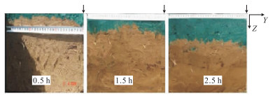
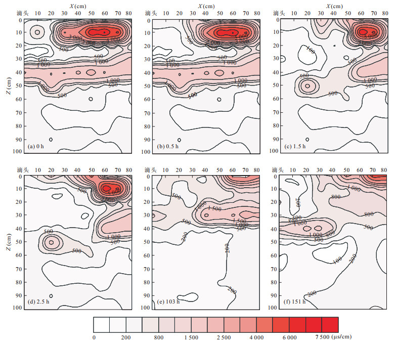
Brilliant Blue FCF was used to trace water flow in cotton field of mulched drip-irrigation using brackish water. 13 cross sections were dug before irrigation, during irrigation and after irrigation, respectively, for observation of the movement of wetting front. The soil moistures were in-situ measured at 3 120 points by using MP406 moisture probe and 1 430 soil samples were sampled to analyze soil salinity by extracting soil water with 1:5 of soil to water, while cross sections were divided as each grid 10 cm×10 cm. The meteorology data were measured by WATCHDOG. The results show that the dye tracer can trace soil water flow and salinity transport obviously. There are two infiltrating states for soil water and salinity transport characters in field under film mulched drip-irrigation: point source infiltrating in the direction vertical to drip irrigation pipe and approximate line source infiltrating along with drip irrigation pipe. The velocity of soil wetting front movement was 8cm/h under the present irrigation. The soil salinity near the dripper was leached by irrigation water; however, the salt accumulated in the surface soil without film mulch. The wetting front extended with the irrigation time, and the spreading distance was similar to that with no plants. For efficient use of soil water, the reasonable irrigation quota for the present planting pattern of one film, one irrigation pipe and four row cottons was 29.4-69.8 mm in the study area.
Brilliant Blue FCF was used to trace water flow in cotton field of mulched drip-irrigation using brackish water. 13 cross sections were dug before irrigation, during irrigation and after irrigation, respectively, for observation of the movement of wetting front. The soil moistures were in-situ measured at 3 120 points by using MP406 moisture probe and 1 430 soil samples were sampled to analyze soil salinity by extracting soil water with 1:5 of soil to water, while cross sections were divided as each grid 10 cm×10 cm. The meteorology data were measured by WATCHDOG. The results show that the dye tracer can trace soil water flow and salinity transport obviously. There are two infiltrating states for soil water and salinity transport characters in field under film mulched drip-irrigation: point source infiltrating in the direction vertical to drip irrigation pipe and approximate line source infiltrating along with drip irrigation pipe. The velocity of soil wetting front movement was 8cm/h under the present irrigation. The soil salinity near the dripper was leached by irrigation water; however, the salt accumulated in the surface soil without film mulch. The wetting front extended with the irrigation time, and the spreading distance was similar to that with no plants. For efficient use of soil water, the reasonable irrigation quota for the present planting pattern of one film, one irrigation pipe and four row cottons was 29.4-69.8 mm in the study area.


2012, 37(5): 1101-1108.
doi: 10.3799/dqkx.2012.117
Abstract:
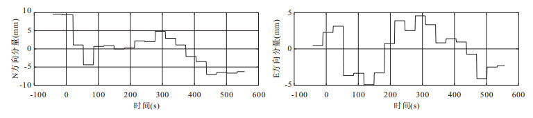
With the development of high-rate GPS receivers, precise orbit and processing technology of GPS data, it is possible to observe the high frequency, transient dynamic displacement by GPS. However, it remains a problem as how to mitigate the error such as multipath errors, and random noise aliasing in geophysical signals so as to extract seismic signals, which in turn limits the high-rate GPS and its geophysical applications. In this paper, an approach based on wavelet packets decomposition (WPD) is presented to extract seismic signals through mitigating the multipath error and random noise of dynamic displacement series from high-rate GPS. With the 1 Hz observation data from 19 stations in Southern California Integrated GPS Network (SCIGN) during the Mexico M7.2 earthquake in 2010, the ground displacement is calculated. Meanwhile, the approach based on WPD is introduced for seismic signal extraction and spectrum analysis. As is shown in results, the approach is accurate and effective in seismic signal extraction to reflect the characteristics of seismic wave propagations and it enjoys an advantage that it does not necessarily involve multiple-day observation.
With the development of high-rate GPS receivers, precise orbit and processing technology of GPS data, it is possible to observe the high frequency, transient dynamic displacement by GPS. However, it remains a problem as how to mitigate the error such as multipath errors, and random noise aliasing in geophysical signals so as to extract seismic signals, which in turn limits the high-rate GPS and its geophysical applications. In this paper, an approach based on wavelet packets decomposition (WPD) is presented to extract seismic signals through mitigating the multipath error and random noise of dynamic displacement series from high-rate GPS. With the 1 Hz observation data from 19 stations in Southern California Integrated GPS Network (SCIGN) during the Mexico M7.2 earthquake in 2010, the ground displacement is calculated. Meanwhile, the approach based on WPD is introduced for seismic signal extraction and spectrum analysis. As is shown in results, the approach is accurate and effective in seismic signal extraction to reflect the characteristics of seismic wave propagations and it enjoys an advantage that it does not necessarily involve multiple-day observation.