2013 Vol. 38, No. 2
Display Method:
 PDF 556KB
2013, 38(2): 211-217.
doi: 10.3799/dqkx.2013.022
Abstract:
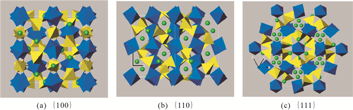
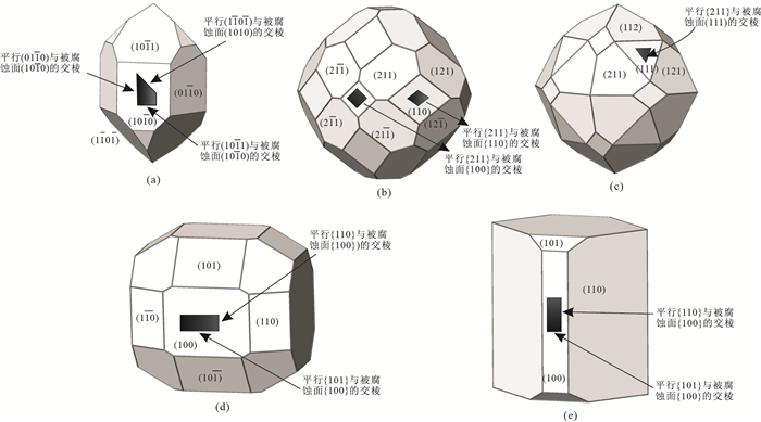
Etch figures of different crystallographic faces on quartz, garnet, olivine, zircon and andalusite have been observed and analyzed. The relationship between etch figures and crystal face symmetry as well as the characteristics of face structures is summarized. It is shown that etch figures can not only reflect the face symmetry, but also reflect the face crystallographic significance. The crystal faces with different crystallographic significance on the same crystal must have different etch figures, even though they may have the same symmetry. However, the faces with the same symmetry among different crystals maybe have the same etch figures. Etch figures are mainly related to the face symmetry, similar to the crystal morphology, but not related to the detailed arrangement of the atoms or ions on the faces. The etch figures formed by different solvents on the same face may be completely different. Some etch figures can be explained by the intersection edges between the growth faces on the crystal habit and the etching face. This research clarifies the mechanism of resolved shapes on crystals, illustrates the relationship between the resolved morphology and growth morphology and indicates the acid or alkali environment of the crystals.
Etch figures of different crystallographic faces on quartz, garnet, olivine, zircon and andalusite have been observed and analyzed. The relationship between etch figures and crystal face symmetry as well as the characteristics of face structures is summarized. It is shown that etch figures can not only reflect the face symmetry, but also reflect the face crystallographic significance. The crystal faces with different crystallographic significance on the same crystal must have different etch figures, even though they may have the same symmetry. However, the faces with the same symmetry among different crystals maybe have the same etch figures. Etch figures are mainly related to the face symmetry, similar to the crystal morphology, but not related to the detailed arrangement of the atoms or ions on the faces. The etch figures formed by different solvents on the same face may be completely different. Some etch figures can be explained by the intersection edges between the growth faces on the crystal habit and the etching face. This research clarifies the mechanism of resolved shapes on crystals, illustrates the relationship between the resolved morphology and growth morphology and indicates the acid or alkali environment of the crystals.


2013, 38(2): 218-232.
doi: 10.3799/dqkx.2013.023
Abstract:
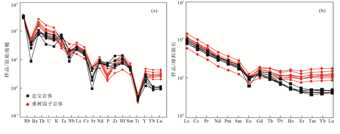
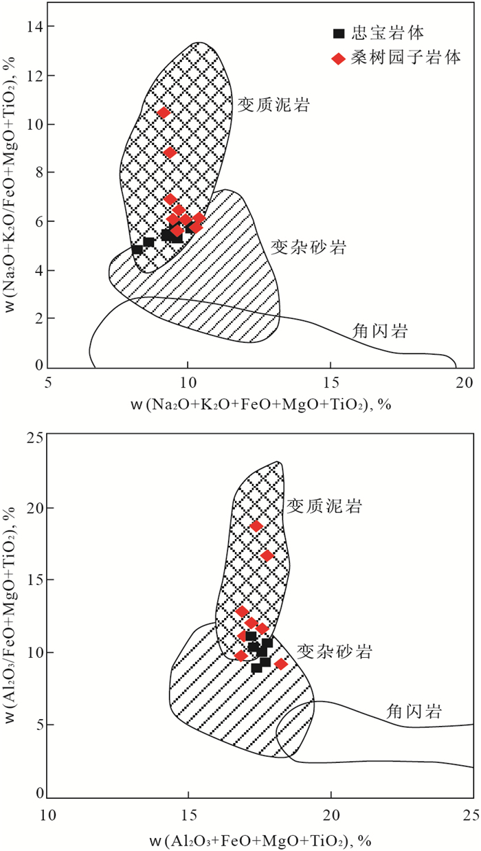
Granitoids are widely distributed in east part of south Tianshan orogen, forming a NWW orientated granite belt along Kumishi fault. Zhongbao and Sangshuyuanzi skarn-type tungsten deposits have been discovered in this region and the mineralization is closely related to two-mica granites. LA-ICP-MS U-Pb zircon dating yields the ages of Zhongbao and Sangshuyuanzi granites of 296±4 Ma and 293±3 Ma, respectively, which belong to Late Carboniferous-Early Permian. Both of the granites are peraluminous (A/CNK=1.11-1.48, 1.05-1.11) with high contents of SiO2 (72.51%-74.84%, 70.68%-74.14%) and primary muscovites, which show the characteristics of syn-collision S-type granites. The samples are characterized with enriched LILE, LREE and loss of HFSE, with HREE showing moderate negative Eu anomalies. ISr values of two granites range from 0.707 6 to 0.708 8 and 0.706 5 to 0.707 7; εNd(t) values range from -6.3 to-7.1 and -4.7 to -5.1; Nd single-stage modle ages (TDM) range from 1.59 to 1.8 Ga and 1.50 to 1.56 Ga, and the old inherited zircon ages range from 2.5 to 0.8 Ga. The above data indicate that the two granites are derived from partial melting of metapelites of Xingxingxia group and might contain mix greywacke ingredients, suggesting that there exists Precambrian basement in the eastern part of South Tianshan. Based on this research and previous studies as well, we are convinced that South Tianshan ocean finally closed in Late Carboniferous-Early Permian and the appearance of A-type granites and mafic magmatism means that the south Tianshan orogenic belt enters the post-orogenic stage.Tungsten-rich Xingxingxia Group is the possible source of regional tungsten mineralization and the conversion stage from syn-collision to post-collision is the advantageous matallotecttonic system. Xingxingxia Group that had experienced the polycycle tectonism remelted again in orogenic processes in Early Permian, resulting in the final concentration of ore-forming elements.
Granitoids are widely distributed in east part of south Tianshan orogen, forming a NWW orientated granite belt along Kumishi fault. Zhongbao and Sangshuyuanzi skarn-type tungsten deposits have been discovered in this region and the mineralization is closely related to two-mica granites. LA-ICP-MS U-Pb zircon dating yields the ages of Zhongbao and Sangshuyuanzi granites of 296±4 Ma and 293±3 Ma, respectively, which belong to Late Carboniferous-Early Permian. Both of the granites are peraluminous (A/CNK=1.11-1.48, 1.05-1.11) with high contents of SiO2 (72.51%-74.84%, 70.68%-74.14%) and primary muscovites, which show the characteristics of syn-collision S-type granites. The samples are characterized with enriched LILE, LREE and loss of HFSE, with HREE showing moderate negative Eu anomalies. ISr values of two granites range from 0.707 6 to 0.708 8 and 0.706 5 to 0.707 7; εNd(t) values range from -6.3 to-7.1 and -4.7 to -5.1; Nd single-stage modle ages (TDM) range from 1.59 to 1.8 Ga and 1.50 to 1.56 Ga, and the old inherited zircon ages range from 2.5 to 0.8 Ga. The above data indicate that the two granites are derived from partial melting of metapelites of Xingxingxia group and might contain mix greywacke ingredients, suggesting that there exists Precambrian basement in the eastern part of South Tianshan. Based on this research and previous studies as well, we are convinced that South Tianshan ocean finally closed in Late Carboniferous-Early Permian and the appearance of A-type granites and mafic magmatism means that the south Tianshan orogenic belt enters the post-orogenic stage.Tungsten-rich Xingxingxia Group is the possible source of regional tungsten mineralization and the conversion stage from syn-collision to post-collision is the advantageous matallotecttonic system. Xingxingxia Group that had experienced the polycycle tectonism remelted again in orogenic processes in Early Permian, resulting in the final concentration of ore-forming elements.


2013, 38(2): 233-240.
doi: 10.3799/dqkx.2013.024
Abstract:
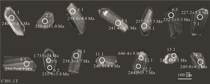
Chajian No.1 rock mass is the main ore-forming rock mass in Chajian deposit, its lithofacies include pyroxene-peridotite, olivine-pyroxene-amphibolite, Hornblende-pyroxenite, gabbro and diorite-pegmatite.The results of gabbro zircon SHRIMP U-Pb dating show that mafic-ultramafic rock masses formed in the Late Triassic and the age is 239.6±2.6 Ma. The existing age data of mafic-ultramafic rocks indicate that the formation age of the rock masses become new in turn from southwest to northeast. The formation age of Chajian No.1 rock mass is earlier than that of Hongqiling rock mass significantly, age difference between them can reach 20 Ma. Mafic-ultramafic magmatism activities in Hongqiling district began before 240 Ma and lasted for a long time. The finding of 1.7 Ga and 0.6 Ga zircon cores is direct evidence of magma mixed with crustal material. The ages of captured zircons are corresponding with those of Neoproterozoic and Mesoproterozoic tectonic heat events in the North China Platform, suggesting that their origin is North China platform basement.
Chajian No.1 rock mass is the main ore-forming rock mass in Chajian deposit, its lithofacies include pyroxene-peridotite, olivine-pyroxene-amphibolite, Hornblende-pyroxenite, gabbro and diorite-pegmatite.The results of gabbro zircon SHRIMP U-Pb dating show that mafic-ultramafic rock masses formed in the Late Triassic and the age is 239.6±2.6 Ma. The existing age data of mafic-ultramafic rocks indicate that the formation age of the rock masses become new in turn from southwest to northeast. The formation age of Chajian No.1 rock mass is earlier than that of Hongqiling rock mass significantly, age difference between them can reach 20 Ma. Mafic-ultramafic magmatism activities in Hongqiling district began before 240 Ma and lasted for a long time. The finding of 1.7 Ga and 0.6 Ga zircon cores is direct evidence of magma mixed with crustal material. The ages of captured zircons are corresponding with those of Neoproterozoic and Mesoproterozoic tectonic heat events in the North China Platform, suggesting that their origin is North China platform basement.


2013, 38(2): 241-252.
doi: 10.3799/dqkx.2013.025
Abstract:
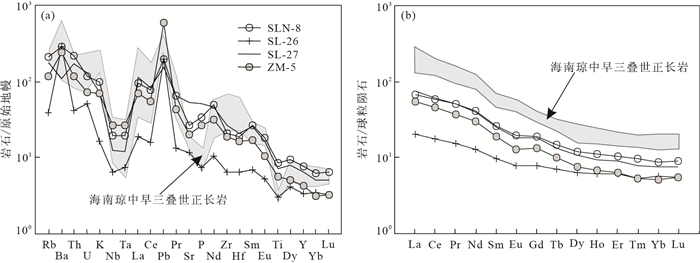
The Shilu iron deposit is located in western section of the Wuzhishan Fold Belt, Hainan island.In this region, numerous intermediate-basic dikes dominated by diorite-porphyrite occurred. The dating of zircon from diorite-porphyrite dikes determined by LA-ICP-MS yields age of 248±1 Ma (MSWD=0.4), maybe bimodal intrusion with contemporary alkali-rich granites. Diorite-porphyrite dikes are dominated by shoshonitic rocks, which have SiO2 varying from 49.18% to 55.25%, Al2O3 from 14.36% to 16.75%, FeOt from 5.98% to 10.07% and MgO ranging from 3.80% to 5.43%. These dikes are enriched in large ion lithophile elements (LILE) and low rare earth elements (LREE) but depleted in high field strength element (HFSE).The Nb/Ta values of diorite-porphyrite vary from 15.33 to 17.80, Zr/Hf and La/Nb from 36.00 to 45.23 and 2.59 to 8.62, respectively.Two samples have (206Pb/204Pb)t=18.087-18.483, (207Pb/204Pb)t=15.473-15.589 and (208Pb/204Pb)t=38.272-38.817, similar to the data of contemporary alkali-rich granites. Geochemical and Pb isotopic compositions indicate that these dikes are possibly derived from enriched mantle and slightly contaminated with crust.Hf/3-Th-Ta and Zr-Zr/Y discriminant diagrams imply these diorite-porphyrite dikes intruded in a local nextensional tectonic setting in continental arc, caused by the Indian plate northeastern subduction to the South China Block.
The Shilu iron deposit is located in western section of the Wuzhishan Fold Belt, Hainan island.In this region, numerous intermediate-basic dikes dominated by diorite-porphyrite occurred. The dating of zircon from diorite-porphyrite dikes determined by LA-ICP-MS yields age of 248±1 Ma (MSWD=0.4), maybe bimodal intrusion with contemporary alkali-rich granites. Diorite-porphyrite dikes are dominated by shoshonitic rocks, which have SiO2 varying from 49.18% to 55.25%, Al2O3 from 14.36% to 16.75%, FeOt from 5.98% to 10.07% and MgO ranging from 3.80% to 5.43%. These dikes are enriched in large ion lithophile elements (LILE) and low rare earth elements (LREE) but depleted in high field strength element (HFSE).The Nb/Ta values of diorite-porphyrite vary from 15.33 to 17.80, Zr/Hf and La/Nb from 36.00 to 45.23 and 2.59 to 8.62, respectively.Two samples have (206Pb/204Pb)t=18.087-18.483, (207Pb/204Pb)t=15.473-15.589 and (208Pb/204Pb)t=38.272-38.817, similar to the data of contemporary alkali-rich granites. Geochemical and Pb isotopic compositions indicate that these dikes are possibly derived from enriched mantle and slightly contaminated with crust.Hf/3-Th-Ta and Zr-Zr/Y discriminant diagrams imply these diorite-porphyrite dikes intruded in a local nextensional tectonic setting in continental arc, caused by the Indian plate northeastern subduction to the South China Block.


2013, 38(2): 253-265.
doi: 10.3799/dqkx.2013.026
Abstract:
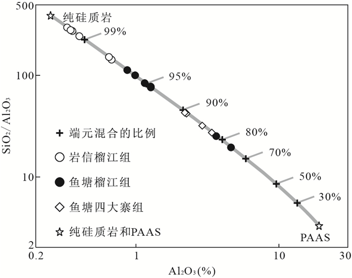
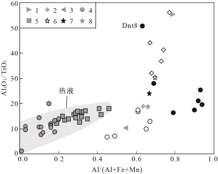
The Napo rift basin on the southern margin of the Youjiang basin was dominated by deep-water sediments including cherts, mudstones and marine basalts during the Late Paleozoic. Major and rare earth elements of the Upper Devonian Liujiang Formation and Lower-Middle Permian Sidazhai Formation cherts in Napo are analyzed in this study. The SiO2 contents of samples range from 88.55% to 99.03%, and the PAAS components are less than 20%, which indicate few terrigenous clastic components in the Upper Paleozoic cherts. The high Al/(Al+Fe+Mn) ratios (0.45 to 0.94) and no positive Eu anomalies (0.51 to 0.95) indicate non-hydrothermal origins. Considering the effect of diagenetic SiO2 dilution, their ∑REE+Y values are between twice and five times those of PAAS-like compositions, indicating that they were deposited in a basin far away from the terrigenous input environment. The Upper Devonian Liujiang Formation of Yanxin and Yutang have moderately negative Ce anomalies (0.37 to 0.72, 0.58 to 0.89, respectively) and higher Y/Ho ratios (39.05 to 83.74, 34.33 to 36.70, respectively), indicating these cherts were deposited in the open-rift basin far away from the terrigenous input. The Lower-Middle Permian Sidazhai Formation cherts of Yutang show similar geochemistry characteristics of the mature ocean basin cherts, with obviously negative Ce anomalies (Ce/Ce*=0.12 to 0.33). On the basis of our studies about cherts, we conclude that the depositional chemistry of the Upper Paleozoic cherts records the evolution process of the Youjiang basin from the rift basin during the Late Devonian into an open-ocean basin during the Early-Middle Permian.
The Napo rift basin on the southern margin of the Youjiang basin was dominated by deep-water sediments including cherts, mudstones and marine basalts during the Late Paleozoic. Major and rare earth elements of the Upper Devonian Liujiang Formation and Lower-Middle Permian Sidazhai Formation cherts in Napo are analyzed in this study. The SiO2 contents of samples range from 88.55% to 99.03%, and the PAAS components are less than 20%, which indicate few terrigenous clastic components in the Upper Paleozoic cherts. The high Al/(Al+Fe+Mn) ratios (0.45 to 0.94) and no positive Eu anomalies (0.51 to 0.95) indicate non-hydrothermal origins. Considering the effect of diagenetic SiO2 dilution, their ∑REE+Y values are between twice and five times those of PAAS-like compositions, indicating that they were deposited in a basin far away from the terrigenous input environment. The Upper Devonian Liujiang Formation of Yanxin and Yutang have moderately negative Ce anomalies (0.37 to 0.72, 0.58 to 0.89, respectively) and higher Y/Ho ratios (39.05 to 83.74, 34.33 to 36.70, respectively), indicating these cherts were deposited in the open-rift basin far away from the terrigenous input. The Lower-Middle Permian Sidazhai Formation cherts of Yutang show similar geochemistry characteristics of the mature ocean basin cherts, with obviously negative Ce anomalies (Ce/Ce*=0.12 to 0.33). On the basis of our studies about cherts, we conclude that the depositional chemistry of the Upper Paleozoic cherts records the evolution process of the Youjiang basin from the rift basin during the Late Devonian into an open-ocean basin during the Early-Middle Permian.


2013, 38(2): 266-276.
doi: 10.3799/dqkx.2013.027
Abstract:
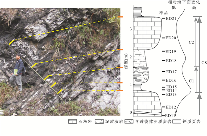
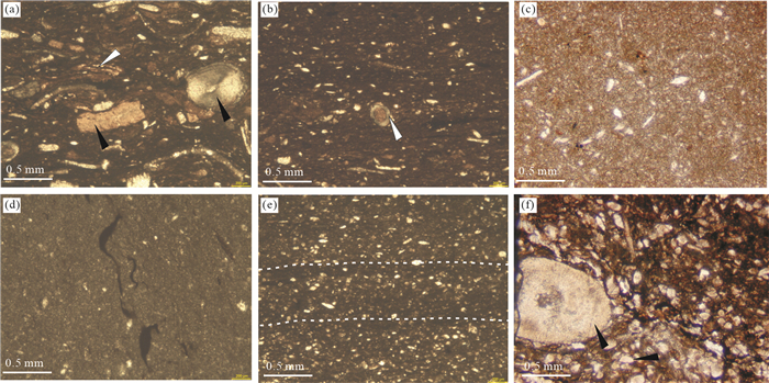
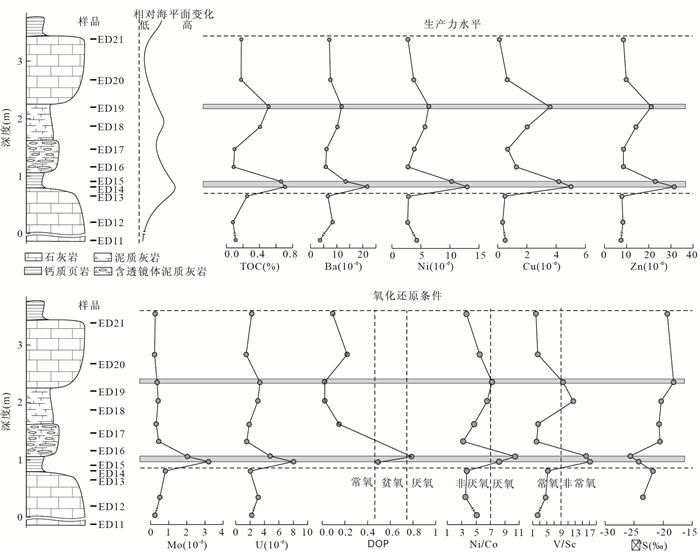
The Middle Permian Chihsian Formation in Sangzhi area in western Hunan Province shows remarkable cyclicity, where organic matter cycles also occurred. The study of origin of organic matter accumulation in the Chihsian Formation helps understand the role of sea level fluctuation on the formation of organic-carbon-rich sediments. Using a cycle as the study interval, based on the study of pyrite morphology and geochemical parameters, such as TOC, δ34S, DOP and trace elements, we find out that the variation of ocean surface water primary productivity parameters, such as Ba, Ni, Cu and Zn, are consistent with TOC contents, suggesting organic matter accumulation was controlled by primary productivity. The redox condition in bottom water is related to primary productivity. The ultimate origin for the organic matter accumulation should be the high-frequency sea level fluctuation. Rapid sea level rising brought rich nutrients, flourishing surface water biologic productivity. The decomposition of organic matter from dead body demanded more oxygen concentration, resulting in dysoxic-anoxic environment in bottom water.
The Middle Permian Chihsian Formation in Sangzhi area in western Hunan Province shows remarkable cyclicity, where organic matter cycles also occurred. The study of origin of organic matter accumulation in the Chihsian Formation helps understand the role of sea level fluctuation on the formation of organic-carbon-rich sediments. Using a cycle as the study interval, based on the study of pyrite morphology and geochemical parameters, such as TOC, δ34S, DOP and trace elements, we find out that the variation of ocean surface water primary productivity parameters, such as Ba, Ni, Cu and Zn, are consistent with TOC contents, suggesting organic matter accumulation was controlled by primary productivity. The redox condition in bottom water is related to primary productivity. The ultimate origin for the organic matter accumulation should be the high-frequency sea level fluctuation. Rapid sea level rising brought rich nutrients, flourishing surface water biologic productivity. The decomposition of organic matter from dead body demanded more oxygen concentration, resulting in dysoxic-anoxic environment in bottom water.


2013, 38(2): 277-288.
doi: 10.3799/dqkx.2013.028
Abstract:
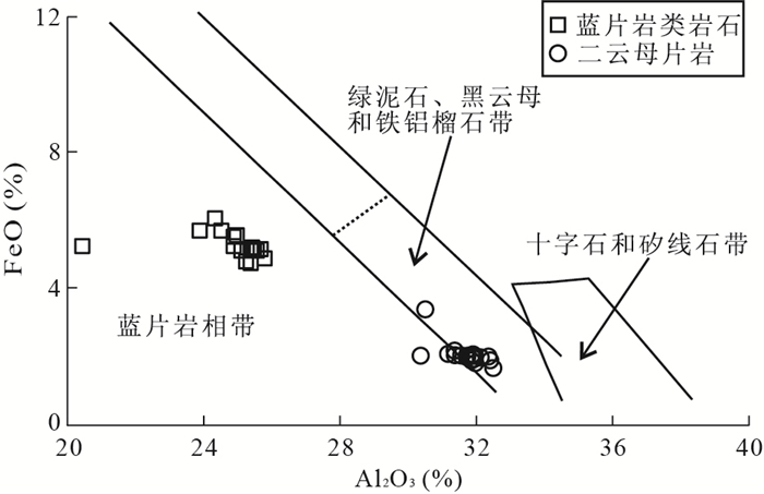
A sequence of middle-high-pressure metamorphic rocks occurs in the Heilongjiang Complex, whose representative lithology is blueschist and mica schist. Characteristic minerals of middle-high-pressure metamorphism, such as glaucophane, ferro-glaucophane and phengite (Si=3.37 to 3.46 > 3.30) are observed in the metamorphic rocks. The rock association, blueschist and mica schist, has suffered at least two stages of metamorphism. The P-T conditions are estimated to be 320 to 460 ℃ and 7.8×10⁸ to 11×108 Pa, which correspond to early stage epidote-blueschist facies. The late stage is high-greenschist facies, which is characterized by the replacement of glaucophane and phengite by magnesium-rich (XMg=0.565 to 0.646) chlorite. The metamorphic conditions constrained by garnet mica schist are 536~598 ℃ and 6.8×10⁸ to 9.5×10⁸ Pa, consistent with medium temperature and middle-high pressure metamorphism.
A sequence of middle-high-pressure metamorphic rocks occurs in the Heilongjiang Complex, whose representative lithology is blueschist and mica schist. Characteristic minerals of middle-high-pressure metamorphism, such as glaucophane, ferro-glaucophane and phengite (Si=3.37 to 3.46 > 3.30) are observed in the metamorphic rocks. The rock association, blueschist and mica schist, has suffered at least two stages of metamorphism. The P-T conditions are estimated to be 320 to 460 ℃ and 7.8×10⁸ to 11×108 Pa, which correspond to early stage epidote-blueschist facies. The late stage is high-greenschist facies, which is characterized by the replacement of glaucophane and phengite by magnesium-rich (XMg=0.565 to 0.646) chlorite. The metamorphic conditions constrained by garnet mica schist are 536~598 ℃ and 6.8×10⁸ to 9.5×10⁸ Pa, consistent with medium temperature and middle-high pressure metamorphism.


2013, 38(2): 289-304.
doi: 10.3799/dqkx.2013.029
Abstract:
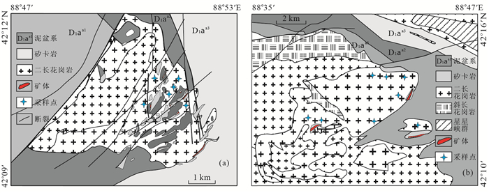
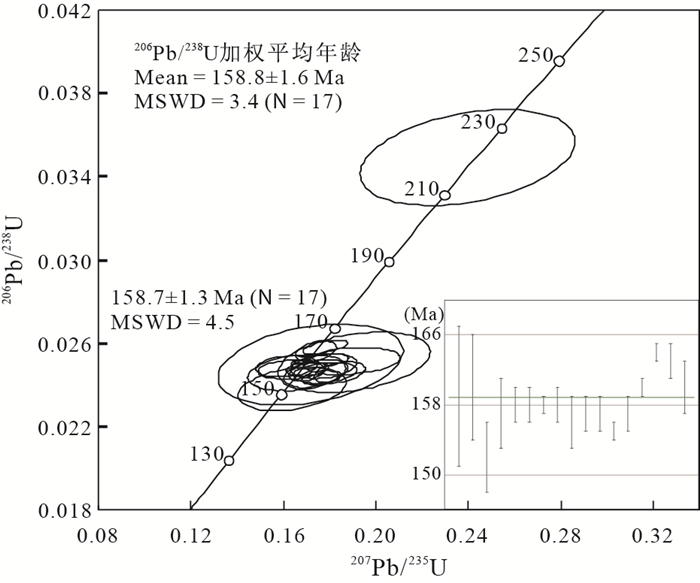
The newly discovered large-scale Shangfang tungsten deposit represents a new type of tungsten mineralization in Fujian Province, offering new pespectives for exploration of tungsten deposits in the province. The ore bodies are mostly hosted in amphibolite and biotite leptynite of the Paleoproterozoic Dajinshan Formation proximal to the Shangfang syenogranite intrusion and, less significantly, in the contact zone between the intrusion and the metamorphic rocks. Tungsten mineralization consists of quartz-scheelite veins and disseminated scheelite in alteration assemblages, with scheelite and molybdenite as the main ore minerals coexisting with minor pyrrhotite, pyrite, and chalcopyrite. Field relations and petrographic characterization indicate that the Shangfang deposit is typified by skarn mineralization. Zircons from the Shangfang syenogranite intrusion have LA-ICP-MS U-Pb age of 158.8±1.6 Ma (1σ), whereas five molybdenite separates yield model ages ranging from 159.40±0.86 to 149.92±1.39 Ma with a weighted mean of 156.5 ± 4.0 Ma, which is consistent with an isochrone age of 158.1±5.4 Ma (2σ). The geochronological data thus demonstrate that the Shangfang tungsten deposit formed in the Late Jurassic and is genetically related to the syenogranite intrusion in the mine. The data also indicate that the Shangfang deposit resulted from the pervasive Late Mesozoic tunsgten mineralization in South China. It has long been considered that the Late Jurassic tungsten metallogenic belt in South China is restricted in the middle-eastern portion of the Nanling Range covering areas of southern Hunan, northern Guangdong, and southern Jiangxi Province. The discovery of the Shangfang deposit, however, allows this metallogenic belt to extend into western and northern Fujian Province, which is an integral part of the Wuyishan metallogenic belt. As such, the South China polymetallic belt is distributed along a northeast strike, rather than an east-west extension as previously thought, and can be regarded as an important part of the giant Circle-Pacific tectono-magmtic-metallogenic domain.
The newly discovered large-scale Shangfang tungsten deposit represents a new type of tungsten mineralization in Fujian Province, offering new pespectives for exploration of tungsten deposits in the province. The ore bodies are mostly hosted in amphibolite and biotite leptynite of the Paleoproterozoic Dajinshan Formation proximal to the Shangfang syenogranite intrusion and, less significantly, in the contact zone between the intrusion and the metamorphic rocks. Tungsten mineralization consists of quartz-scheelite veins and disseminated scheelite in alteration assemblages, with scheelite and molybdenite as the main ore minerals coexisting with minor pyrrhotite, pyrite, and chalcopyrite. Field relations and petrographic characterization indicate that the Shangfang deposit is typified by skarn mineralization. Zircons from the Shangfang syenogranite intrusion have LA-ICP-MS U-Pb age of 158.8±1.6 Ma (1σ), whereas five molybdenite separates yield model ages ranging from 159.40±0.86 to 149.92±1.39 Ma with a weighted mean of 156.5 ± 4.0 Ma, which is consistent with an isochrone age of 158.1±5.4 Ma (2σ). The geochronological data thus demonstrate that the Shangfang tungsten deposit formed in the Late Jurassic and is genetically related to the syenogranite intrusion in the mine. The data also indicate that the Shangfang deposit resulted from the pervasive Late Mesozoic tunsgten mineralization in South China. It has long been considered that the Late Jurassic tungsten metallogenic belt in South China is restricted in the middle-eastern portion of the Nanling Range covering areas of southern Hunan, northern Guangdong, and southern Jiangxi Province. The discovery of the Shangfang deposit, however, allows this metallogenic belt to extend into western and northern Fujian Province, which is an integral part of the Wuyishan metallogenic belt. As such, the South China polymetallic belt is distributed along a northeast strike, rather than an east-west extension as previously thought, and can be regarded as an important part of the giant Circle-Pacific tectono-magmtic-metallogenic domain.


2013, 38(2): 305-316.
doi: 10.3799/dqkx.2013.030
Abstract:
Nanquanyan diorite, hardly well-studied, is the metallogenic intrusion of the Lanjia skarn type gold deposit. Based on the studies of geochemistry, zircon LA-ICP-MS U-Pb data, this paper mainly discusses petrogenesis, magma source, tectonics setting of the diorite. Studies show that Nanquanyan diorite belongs to calc-alkaline and metaluminous series. The trace elements of diorite show enrichment in LILE (such as K, Rb, Sr), more mobile incompatible elements (such as Th, U) and LREE, relative depletment of HFSE (such as Nb, Ta, Ti, P) and HREE, and show obvious negative Eu anomalies (δEu=0.19~0.25). The ratios of Nb/Ta, La/Nb and Th/La indicate that the diorite mainly comes from the crust. In the Al2O3+MgO+FeOt diagram, the characteristics of the diorite are similar to those of arc-type active continental margin magmatic rocks. LA-ICP-MS U-Pb zircon data of the diorite give weighted average ages of 170.21±0.73 Ma(MSWD=0.14) and concordant age of 170.21±0.39 Ma (MSWD = 0.018), which are in the middle Jurassic period. It is suggested that during the early Yanshan, subduction of Pacific plate led to extension of continental arc and lithospheric thinning, and asthenosphere mantle magma underplated subsequently and provided thermopower, finally partial melting of the immature lower crurst formed Nanquanyan diorite.
Nanquanyan diorite, hardly well-studied, is the metallogenic intrusion of the Lanjia skarn type gold deposit. Based on the studies of geochemistry, zircon LA-ICP-MS U-Pb data, this paper mainly discusses petrogenesis, magma source, tectonics setting of the diorite. Studies show that Nanquanyan diorite belongs to calc-alkaline and metaluminous series. The trace elements of diorite show enrichment in LILE (such as K, Rb, Sr), more mobile incompatible elements (such as Th, U) and LREE, relative depletment of HFSE (such as Nb, Ta, Ti, P) and HREE, and show obvious negative Eu anomalies (δEu=0.19~0.25). The ratios of Nb/Ta, La/Nb and Th/La indicate that the diorite mainly comes from the crust. In the Al2O3+MgO+FeOt diagram, the characteristics of the diorite are similar to those of arc-type active continental margin magmatic rocks. LA-ICP-MS U-Pb zircon data of the diorite give weighted average ages of 170.21±0.73 Ma(MSWD=0.14) and concordant age of 170.21±0.39 Ma (MSWD = 0.018), which are in the middle Jurassic period. It is suggested that during the early Yanshan, subduction of Pacific plate led to extension of continental arc and lithospheric thinning, and asthenosphere mantle magma underplated subsequently and provided thermopower, finally partial melting of the immature lower crurst formed Nanquanyan diorite.


2013, 38(2): 317-328.
doi: 10.3799/dqkx.2013.031
Abstract:
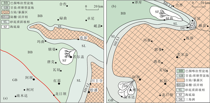
Based on analysis of the sedimentary features, fission track data, ESR dating and Ar-Ar dating, we argue that there are seven tectono-thermal events in Zoige and its periphery from the Late Triassic. The first tectono-thermal events (D1) took place at the end of the Carnian to the beginning of the Norian stage to form the tectonic framework of Zoige area; the second (D2) and the fourth (D4) tectono-thermal events took place at the early of Jurassic (200-180 Ma) and 130-110 Ma, respectively. They are the key change events in tectonic framework at each time. The seventh (D7) took place at the early of Miocene (~20 Ma), as the most important tectonic event to form the Tibet Plateau. The other three events (D3, D5, D6) took place at 160-140 Ma, 70-60 Ma, 50-40 Ma, respectively.
Based on analysis of the sedimentary features, fission track data, ESR dating and Ar-Ar dating, we argue that there are seven tectono-thermal events in Zoige and its periphery from the Late Triassic. The first tectono-thermal events (D1) took place at the end of the Carnian to the beginning of the Norian stage to form the tectonic framework of Zoige area; the second (D2) and the fourth (D4) tectono-thermal events took place at the early of Jurassic (200-180 Ma) and 130-110 Ma, respectively. They are the key change events in tectonic framework at each time. The seventh (D7) took place at the early of Miocene (~20 Ma), as the most important tectonic event to form the Tibet Plateau. The other three events (D3, D5, D6) took place at 160-140 Ma, 70-60 Ma, 50-40 Ma, respectively.


2013, 38(2): 329-338.
doi: 10.3799/dqkx.2013.032
Abstract:
Katla volcano shows an increased level of unrest recently.Therefore people are increasingly more concerned with the probability, scale and pattern of eruption from Katla volcano, and the potential influence as well. We deduce preliminarily the possible behavior pattern and the effect of the Katla volcano for its future eruption according to the speech "the past is a key to the present", based on collecting some published materials from international journals and internet. According to the eruption history of Katla volcano, a probability of volcanic eruption in 2013 is roughly 30%. The magnitude of next eruption of Katla should be VEI 4, but VEI 5 is also possible. Its eruption pattern has 3 possibilities: the first one is an explosive eruption that breaks through the thick ice cover; the second one is magmatic eruption; the third one is a "failed eruption". From the available information, it indicates that this unrest will be most likely to end up with no eruption.
Katla volcano shows an increased level of unrest recently.Therefore people are increasingly more concerned with the probability, scale and pattern of eruption from Katla volcano, and the potential influence as well. We deduce preliminarily the possible behavior pattern and the effect of the Katla volcano for its future eruption according to the speech "the past is a key to the present", based on collecting some published materials from international journals and internet. According to the eruption history of Katla volcano, a probability of volcanic eruption in 2013 is roughly 30%. The magnitude of next eruption of Katla should be VEI 4, but VEI 5 is also possible. Its eruption pattern has 3 possibilities: the first one is an explosive eruption that breaks through the thick ice cover; the second one is magmatic eruption; the third one is a "failed eruption". From the available information, it indicates that this unrest will be most likely to end up with no eruption.


2013, 38(2): 339-350.
doi: 10.3799/dqkx.2013.033
Abstract:
Lunar dust is the small particle widely distributed on the lunar surface, of which sizes range from 30 nm to 20 μm with the median diameter of 100-300 nm and more than 95% are less than 2 μm. The grains have complex shapes and usually show glass beads, vesicular texture, and angular shards. High contents of agglutinate glass and npFe0 are the remarkable properties in mineral composition. The glass content is usually more than 50 vol%, and it can reach 80% to 90% in < 2.5 μm part. Lunar dust is similar to lunar soil in elemental compositions, but it also shows different contents of SiO2 in different areas. The composition and geometrical characteristics of lunar dust lead to special electromagnetic properties and biological toxicity. These properties might cause the lunar dust adhered to spacecraft and inhaled by astronauts easily, and then damage the spacecraft and threaten the health of astronauts. So, it is necessary to study lunar dust further to facilitate lunar surface exploration, which also can better the understanding of the evolution of lunar surface materials and lunar atmosphere due to the fact that lunar dust has been formed during a long time space weathering and conserves important information of space weathering history in the composition and microstructure of lunar dust grain. Currently, the properties of lunar dust grains in micro-morphology and chemical composition, electromagnetic properties and spectral characteristics, the feature and origin of npFe0 are still not clear, which challenges the understanding of the mechanism of lunar dust's adhesion, biological toxicity and space weathering. To meet the needs of lunar science and lunar exploration, studying the properties of lunar soil grains and process of space weathering by simulated experiments using lunar dust stimulants as a candidate might be an important trend in the coming decades.
Lunar dust is the small particle widely distributed on the lunar surface, of which sizes range from 30 nm to 20 μm with the median diameter of 100-300 nm and more than 95% are less than 2 μm. The grains have complex shapes and usually show glass beads, vesicular texture, and angular shards. High contents of agglutinate glass and npFe0 are the remarkable properties in mineral composition. The glass content is usually more than 50 vol%, and it can reach 80% to 90% in < 2.5 μm part. Lunar dust is similar to lunar soil in elemental compositions, but it also shows different contents of SiO2 in different areas. The composition and geometrical characteristics of lunar dust lead to special electromagnetic properties and biological toxicity. These properties might cause the lunar dust adhered to spacecraft and inhaled by astronauts easily, and then damage the spacecraft and threaten the health of astronauts. So, it is necessary to study lunar dust further to facilitate lunar surface exploration, which also can better the understanding of the evolution of lunar surface materials and lunar atmosphere due to the fact that lunar dust has been formed during a long time space weathering and conserves important information of space weathering history in the composition and microstructure of lunar dust grain. Currently, the properties of lunar dust grains in micro-morphology and chemical composition, electromagnetic properties and spectral characteristics, the feature and origin of npFe0 are still not clear, which challenges the understanding of the mechanism of lunar dust's adhesion, biological toxicity and space weathering. To meet the needs of lunar science and lunar exploration, studying the properties of lunar soil grains and process of space weathering by simulated experiments using lunar dust stimulants as a candidate might be an important trend in the coming decades.


2013, 38(2): 351-361.
doi: 10.3799/dqkx.2013.034
Abstract:
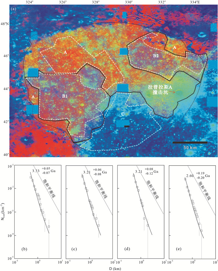
Impact cratering is an important process in planet formation and surface modification.It creats impact craters on the surface, which records and reveals the geological history of the planet. It is known that the younger a surface is, the less amount and smaller diameters the craters on that surface are. Therefore, model ages of a surface region of a solid celestial body can be estimated by measuring the crater size-frequency distribution. We summarized the principles and its application, and applied the method to the age determination of Sinus Iridum on the Moon using images obtained by Lunar Reconnaissance Orbiter Wide Angle Camera. Our results show that this region has three main geological units with model ages of 3.33 Ga, 3.21 Ga and 2.60 Ga, respectively.
Impact cratering is an important process in planet formation and surface modification.It creats impact craters on the surface, which records and reveals the geological history of the planet. It is known that the younger a surface is, the less amount and smaller diameters the craters on that surface are. Therefore, model ages of a surface region of a solid celestial body can be estimated by measuring the crater size-frequency distribution. We summarized the principles and its application, and applied the method to the age determination of Sinus Iridum on the Moon using images obtained by Lunar Reconnaissance Orbiter Wide Angle Camera. Our results show that this region has three main geological units with model ages of 3.33 Ga, 3.21 Ga and 2.60 Ga, respectively.


2013, 38(2): 362-366.
doi: 10.3799/dqkx.2013.035
Abstract:
The Raman spectroscopy of water is combined by O-H stretching vibration peaks with hydrogen bond and O-H stretching vibration peaks with no hydrogen bond in 3 100-3 700 cm-1, which all include symmetric and anti-symmetric stretching fundamentals. So the intensity of hydrogen bonding of H2O molecules in fluid can be obtained by studying on the Raman spectroscopy of water. The hydrogen bonding of water in natural fluid inclusions under the condition of freezing is studied by in-site analysis with a Renishaw MK1-1000 type laser Raman microprobe. The results show that the stretching vibration with hydrogen bond between different H2O molecules is the main movement of H2O molecules below 0 ℃, and the weak stretching vibration with no hydrogen bond in the same molecules is also found in the meantime. The hydrogen bonding of water become stronger with the descent of temperature, and the property of fluid might be discontinuous at -130 to -180 ℃.
The Raman spectroscopy of water is combined by O-H stretching vibration peaks with hydrogen bond and O-H stretching vibration peaks with no hydrogen bond in 3 100-3 700 cm-1, which all include symmetric and anti-symmetric stretching fundamentals. So the intensity of hydrogen bonding of H2O molecules in fluid can be obtained by studying on the Raman spectroscopy of water. The hydrogen bonding of water in natural fluid inclusions under the condition of freezing is studied by in-site analysis with a Renishaw MK1-1000 type laser Raman microprobe. The results show that the stretching vibration with hydrogen bond between different H2O molecules is the main movement of H2O molecules below 0 ℃, and the weak stretching vibration with no hydrogen bond in the same molecules is also found in the meantime. The hydrogen bonding of water become stronger with the descent of temperature, and the property of fluid might be discontinuous at -130 to -180 ℃.


2013, 38(2): 367-378.
doi: 10.3799/dqkx.2013.036
Abstract:
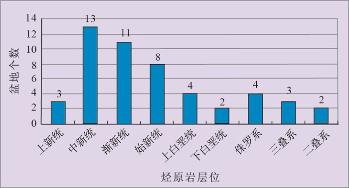
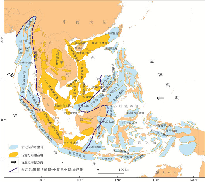
Based on the research of the sedimentary and structural features, hydrocarbon source rocks in the main sedimentary basins in Southeast Asia can be defined into multi-phases and those in Miocene, Oligocene and Eocene are the most important three sets. The pre-Cenozoic source rocks have certain potentials, but with limited distribution. The three sets are mainly fluvial facies to paralic delta with terrigenous kerogen-based coal and carbonaceous shale (mudstone), followed by lacustrine and marine depositional including mudstone and shale. The total organic carbon in these rocks has reached to intermediate to good dominated by Ⅱ-Ⅲ type of kerogen, and most of them are in the stage of mature to over-mature. The generation and distribution of the source rocks are mainly controlled by two geological factors, namely, tectonic evolution and depositional environments of the basins, and closely related to the direction and scale of regional transgression. Therefore, the fractionations in the type and the thermal evolution degree of hydrocarbon source rocks are the most important factors contributing to the various types of oil and gas reservoirs in Southeast Asia.
Based on the research of the sedimentary and structural features, hydrocarbon source rocks in the main sedimentary basins in Southeast Asia can be defined into multi-phases and those in Miocene, Oligocene and Eocene are the most important three sets. The pre-Cenozoic source rocks have certain potentials, but with limited distribution. The three sets are mainly fluvial facies to paralic delta with terrigenous kerogen-based coal and carbonaceous shale (mudstone), followed by lacustrine and marine depositional including mudstone and shale. The total organic carbon in these rocks has reached to intermediate to good dominated by Ⅱ-Ⅲ type of kerogen, and most of them are in the stage of mature to over-mature. The generation and distribution of the source rocks are mainly controlled by two geological factors, namely, tectonic evolution and depositional environments of the basins, and closely related to the direction and scale of regional transgression. Therefore, the fractionations in the type and the thermal evolution degree of hydrocarbon source rocks are the most important factors contributing to the various types of oil and gas reservoirs in Southeast Asia.


2013, 38(2): 379-390.
doi: 10.3799/dqkx.2013.037
Abstract:
Based on the newly released 3D seismic and drilling data in the Kongnan Area, Huanghua Depression, we tracked several sequence boundaries on the seismic profiles and interpreted structure styles and seismic reflection characteristics, which will help us identify an important tectonic unconformity boundary(Ek1Ⅲ) and further classify the episodic stages of tectonic evolution in Paleogene and build up structure-stratigraphic framework in rifting stages of the basin. Furthermore, we analyzed the detailed tectonic evolution processes of the basin with different tectonic episodes of rifting stages by means of backstripping and fault properties, combination types, activity analysis, that confirm that Ek1Ⅲ boundary represents the tectonic revolutionary boundary which imply a rifting initiation from upper First member of Kongdian Formation to Dongying Formation in Kongnan Area. From Third member of Kongdian Formation to lower First member of Kongdian Formation evolution of the basin was controlled by sag effect. At rifing stage, the basin underwent processes from extensional episode to dextral strike-slip and extensional episode.Both of the fault systems and subsidence center have migrated regularly and restricted the distribution of the basin depositional system.
Based on the newly released 3D seismic and drilling data in the Kongnan Area, Huanghua Depression, we tracked several sequence boundaries on the seismic profiles and interpreted structure styles and seismic reflection characteristics, which will help us identify an important tectonic unconformity boundary(Ek1Ⅲ) and further classify the episodic stages of tectonic evolution in Paleogene and build up structure-stratigraphic framework in rifting stages of the basin. Furthermore, we analyzed the detailed tectonic evolution processes of the basin with different tectonic episodes of rifting stages by means of backstripping and fault properties, combination types, activity analysis, that confirm that Ek1Ⅲ boundary represents the tectonic revolutionary boundary which imply a rifting initiation from upper First member of Kongdian Formation to Dongying Formation in Kongnan Area. From Third member of Kongdian Formation to lower First member of Kongdian Formation evolution of the basin was controlled by sag effect. At rifing stage, the basin underwent processes from extensional episode to dextral strike-slip and extensional episode.Both of the fault systems and subsidence center have migrated regularly and restricted the distribution of the basin depositional system.


2013, 38(2): 391-397.
doi: 10.3799/dqkx.2013.038
Abstract:
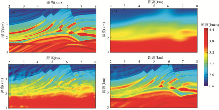
Full waveform inversion uses not only phase and amplitude information, but also waveform details, revealing precise details of the model. We use the LU factorization technique directly to solve the forward modeling, and show a preconditioned gradient method to inverse the velocity structure using the reflected wave from low-frequency to high-frequency in this study. The numerical structure of the finite difference method and back-propagation algorithm is exploited to develop an algorithm that explicitly calculates the Jacobin matrix utilizing a forward model solution. Furthermore, the diagonal elements of the false Hessian matrix are used as the preconditioned operator. Numerical tests on simple synthetic models find that a good velocity model can be obtained only by several frequency inversions, and the strategy of using low-frequency inversion result as the starting model in the high-frequency inversion can greatly reduce the non-uniqueness of their solutions. The initial model directly affects the imaging result. The smooth two-dimensional Gaussian model provides favorable low-frequency information for a better inversion result. The fast convergence can be achieved by using of the false Hessian matrix without any increase in the premise of computation.
Full waveform inversion uses not only phase and amplitude information, but also waveform details, revealing precise details of the model. We use the LU factorization technique directly to solve the forward modeling, and show a preconditioned gradient method to inverse the velocity structure using the reflected wave from low-frequency to high-frequency in this study. The numerical structure of the finite difference method and back-propagation algorithm is exploited to develop an algorithm that explicitly calculates the Jacobin matrix utilizing a forward model solution. Furthermore, the diagonal elements of the false Hessian matrix are used as the preconditioned operator. Numerical tests on simple synthetic models find that a good velocity model can be obtained only by several frequency inversions, and the strategy of using low-frequency inversion result as the starting model in the high-frequency inversion can greatly reduce the non-uniqueness of their solutions. The initial model directly affects the imaging result. The smooth two-dimensional Gaussian model provides favorable low-frequency information for a better inversion result. The fast convergence can be achieved by using of the false Hessian matrix without any increase in the premise of computation.


2013, 38(2): 398-410.
doi: 10.3799/dqkx.2013.039
Abstract:
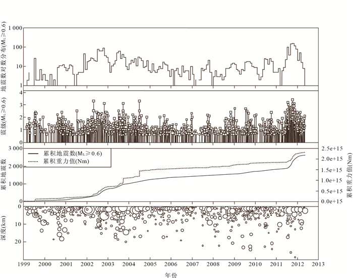
When a major earthquake occurred, it's critical to analyze the influences on the surrounding faults and the potential seismic activity. In this paper, a complex viscoelastic model of western Sichuan and eastern Tibet regions is constructed including the topography, and then we find out the Coulomb failure stressing rate on these major faults and calculate the stress change caused by the Wenchuan earthquake taking the post-seismic relaxation into consideration. Our preliminary results indicate that: (1) the Coulomb stressing rate in the Longmen Shan fault is lower with values from 0.28×10⁻³ MPa/a to 0.35×10⁻³ MPa/a, which is consistent with the previous long reccurrence interval of Wenchuan earthquake; (2) The Wenchuan earthquake not only caused the Coulomb failure stress decrease in the source region, but also the stress increase in the northeastern segment, and it's comparatively consistent with the aftershock distribution; (3) The Coulomb failure stress change caused by Wenchuan earthquake showed significant increase on five major fault segments, which were northwestern segment of Xianshui fault, eastern Kunlun fault, Longriba fault, Minjiang fault and Huya fault respectively, also the Coulomb failure stress on the fault plane of the Yushu earthquake was faintly increased; (4) The characteristic earthquake recurrence interval of the Xianshui fault is delayed by 52-104 a deduced from the Wenchuan earthquake, so it's ranked the high seismic hazard region in the future.
When a major earthquake occurred, it's critical to analyze the influences on the surrounding faults and the potential seismic activity. In this paper, a complex viscoelastic model of western Sichuan and eastern Tibet regions is constructed including the topography, and then we find out the Coulomb failure stressing rate on these major faults and calculate the stress change caused by the Wenchuan earthquake taking the post-seismic relaxation into consideration. Our preliminary results indicate that: (1) the Coulomb stressing rate in the Longmen Shan fault is lower with values from 0.28×10⁻³ MPa/a to 0.35×10⁻³ MPa/a, which is consistent with the previous long reccurrence interval of Wenchuan earthquake; (2) The Wenchuan earthquake not only caused the Coulomb failure stress decrease in the source region, but also the stress increase in the northeastern segment, and it's comparatively consistent with the aftershock distribution; (3) The Coulomb failure stress change caused by Wenchuan earthquake showed significant increase on five major fault segments, which were northwestern segment of Xianshui fault, eastern Kunlun fault, Longriba fault, Minjiang fault and Huya fault respectively, also the Coulomb failure stress on the fault plane of the Yushu earthquake was faintly increased; (4) The characteristic earthquake recurrence interval of the Xianshui fault is delayed by 52-104 a deduced from the Wenchuan earthquake, so it's ranked the high seismic hazard region in the future.


2013, 38(2): 411-416.
doi: 10.3799/dqkx.2013.040
Abstract:
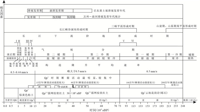
According to the regional survey for geo-hazards, thousands of landslides occurred in the Three Gorges reservoir area. Chronology studies show that these landslides mostly occurred after the Mid-Pleistocene and could be divided in 3 stages, namely, (41-37)×104 aBP, (31-27)×104 aBP and (17-5)×104 aBP. These landslides mostly occurred in the interglacial period and could be well related with the regional uplift and geological process of the formation of river landform in the Three Gorges area. Based on these, we conclude that the occurrence of the landslides can be well correlated with tectonic uplift, climate change, rapidly down-cutting and breakthrough development in the Yangtze River. It is inferred that the cut-through timing of the Three Gorges probably be Early Pleistocene mainly owing to the loss of landslides which ages older than 54×104 aBP.
According to the regional survey for geo-hazards, thousands of landslides occurred in the Three Gorges reservoir area. Chronology studies show that these landslides mostly occurred after the Mid-Pleistocene and could be divided in 3 stages, namely, (41-37)×104 aBP, (31-27)×104 aBP and (17-5)×104 aBP. These landslides mostly occurred in the interglacial period and could be well related with the regional uplift and geological process of the formation of river landform in the Three Gorges area. Based on these, we conclude that the occurrence of the landslides can be well correlated with tectonic uplift, climate change, rapidly down-cutting and breakthrough development in the Yangtze River. It is inferred that the cut-through timing of the Three Gorges probably be Early Pleistocene mainly owing to the loss of landslides which ages older than 54×104 aBP.

2013, 38(2): 417-422.
doi: 10.3799/dqkx.2013.041
Abstract:
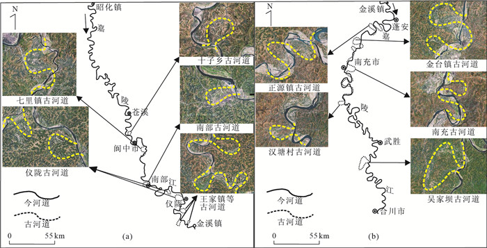
Based on data of the remote sensing and field surveys, the distribution of old channels in the Jialing River is explored. A total of 13 old channels are found and determined. They are distributed mainly in the reach of Langzhong-Nanchong of the Jialing River. Statistical meander parameters indicate that their meander ratio C values are all larger than 3.00, with an average value of 7.80. C values of 4 meander belts are larger than 2.20, and the C value of the whole middle reach of ancient Jialing River is 2.75. All these values are much larger than 1.50, the critical value of meandering rivers, suggesting that the ancient Jialing River has characteristics of meandering river pattern. In addition, it is found that the C value of the ancient river is larger than that of modern channel (It is believed that the larger C value may be associated with the lower gradient value J), indicating a lager degree of curve. It can be concluded that a process of natural cutoff of river has once occurred in the Jialing River.
Based on data of the remote sensing and field surveys, the distribution of old channels in the Jialing River is explored. A total of 13 old channels are found and determined. They are distributed mainly in the reach of Langzhong-Nanchong of the Jialing River. Statistical meander parameters indicate that their meander ratio C values are all larger than 3.00, with an average value of 7.80. C values of 4 meander belts are larger than 2.20, and the C value of the whole middle reach of ancient Jialing River is 2.75. All these values are much larger than 1.50, the critical value of meandering rivers, suggesting that the ancient Jialing River has characteristics of meandering river pattern. In addition, it is found that the C value of the ancient river is larger than that of modern channel (It is believed that the larger C value may be associated with the lower gradient value J), indicating a lager degree of curve. It can be concluded that a process of natural cutoff of river has once occurred in the Jialing River.


2013, 38(2): 423-430.
doi: 10.3799/dqkx.2013.042
Abstract:
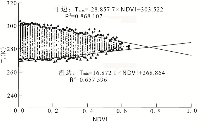
In mountainous areas with eluvium overburden, thickness, moisture and vegetation of the overburden layer may be locally increased where faults are developed in the bedrock. At such localities thermal inertia of the near-surface materials is larger than that in the surrounding areas and relatively low surface temperature due to slower diurnal heating rate may be observed in the daytime. Therefore, the temperature-vegetation-dryness index (TVDI), a combination of surface temperature and vegetation, may be used to retrieve buried faults. Using Landsat7 ETM+ data, we have identified buried faults in this study with TVDI in Yangla copper mining district, Yunnan, which is about 26 km2 in area and is covered by residual deposits for the most part. A distribution map of faults of the district is obtained with linear lows of TVDI as indicators of buried faults combined with visible image interpretation and field investigation. While essential for mining practice in Yangla, our results show a remarkable potential of thermal infrared remote sensing in ore-field geological studies in poorly outcropped regions.
In mountainous areas with eluvium overburden, thickness, moisture and vegetation of the overburden layer may be locally increased where faults are developed in the bedrock. At such localities thermal inertia of the near-surface materials is larger than that in the surrounding areas and relatively low surface temperature due to slower diurnal heating rate may be observed in the daytime. Therefore, the temperature-vegetation-dryness index (TVDI), a combination of surface temperature and vegetation, may be used to retrieve buried faults. Using Landsat7 ETM+ data, we have identified buried faults in this study with TVDI in Yangla copper mining district, Yunnan, which is about 26 km2 in area and is covered by residual deposits for the most part. A distribution map of faults of the district is obtained with linear lows of TVDI as indicators of buried faults combined with visible image interpretation and field investigation. While essential for mining practice in Yangla, our results show a remarkable potential of thermal infrared remote sensing in ore-field geological studies in poorly outcropped regions.


2013, 38(2): 431-440.
doi: 10.3799/dqkx.2013.043
Abstract:
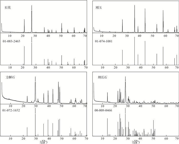
The conventional X-ray diffraction quantitative phase analysis methods are over-reliant on pure standard substances, working curve and K value. If the phases are more than 3, the fitting results are not good by Rietveld method. In addition, the versatility of quantitative methods with large calculation and fussy operation also need to be expanded. A new non-standard quantitative phase analysis method based on nonlinear model parameters estimation method of 4 modular redundant systems that consist of Levenberg-Marquardt, Particle Swarm Optimization, Genetic Algorithm and Differential Evolution is proposed. Taking the content of 4 phases in 19 mixture powder as the original data, performing the whole process of computing in the Matlab environment, the experimental results show that the Levenberg-Marquardt algorithm is an effective tool with smaller computing complexity, faster convergence speed and better global searching capability and other advantages. It is no need to add reference phase to the samples, which overcomes the problems that all the samples must be determined more than one time, and the method with no need for K value which enlarges the applications and enhances the accuracy of the X-ray diffraction method for quantitative phase analysis of the mixture samples. Replacing the conventional specific single spectrum line intensity or intensity rations by the sum of the integrated intensity of the top three peaks can improve the precision of the X-ray diffraction quantitative phase analysis. With this method, the content of Corundum in 82 samples of Zhaosu section in Ili basin and 359 samples in ELJ drilling core of ICDP in Qinghai Lake are computed. The correlation coefficient of the match ratio and the calculated value of Corundum in Zhaosu section and ELJ drilling core have reached 0.83 and 0.63. Practice has proved that it is a feasible, effective, rapid and correct technique of quantitative analysis of minerals, and the stability is satisfactory. It can be used for quantifying the phases in more than 9-phase materials.
The conventional X-ray diffraction quantitative phase analysis methods are over-reliant on pure standard substances, working curve and K value. If the phases are more than 3, the fitting results are not good by Rietveld method. In addition, the versatility of quantitative methods with large calculation and fussy operation also need to be expanded. A new non-standard quantitative phase analysis method based on nonlinear model parameters estimation method of 4 modular redundant systems that consist of Levenberg-Marquardt, Particle Swarm Optimization, Genetic Algorithm and Differential Evolution is proposed. Taking the content of 4 phases in 19 mixture powder as the original data, performing the whole process of computing in the Matlab environment, the experimental results show that the Levenberg-Marquardt algorithm is an effective tool with smaller computing complexity, faster convergence speed and better global searching capability and other advantages. It is no need to add reference phase to the samples, which overcomes the problems that all the samples must be determined more than one time, and the method with no need for K value which enlarges the applications and enhances the accuracy of the X-ray diffraction method for quantitative phase analysis of the mixture samples. Replacing the conventional specific single spectrum line intensity or intensity rations by the sum of the integrated intensity of the top three peaks can improve the precision of the X-ray diffraction quantitative phase analysis. With this method, the content of Corundum in 82 samples of Zhaosu section in Ili basin and 359 samples in ELJ drilling core of ICDP in Qinghai Lake are computed. The correlation coefficient of the match ratio and the calculated value of Corundum in Zhaosu section and ELJ drilling core have reached 0.83 and 0.63. Practice has proved that it is a feasible, effective, rapid and correct technique of quantitative analysis of minerals, and the stability is satisfactory. It can be used for quantifying the phases in more than 9-phase materials.